the geology and mineralization of the coquihalla … 1990-79.pdf · quartz-carbonate...
TRANSCRIPT

Province o f British Columbia Ministry of Energy, Mines and Petroleum Resources Hon. Jack Davis, Minister
MINERAL RESOURCES DIVISION Geological Survey Branch
THE GEOLOGY AND MINERALIZATION OF THE COQUIHALLA GOLD BELT AND HOZAMEEN FAULT SYSTEM, SOUTHWESTERN BRITISH COLUMBIA By Gerald E. Ray
BULLETIN 79
MINERAL RESOURCES DIVISION Geological Survey Branch
Canadian Cataloguing in Publication Data
Ray. G. E. (Gerald E.)
belt and Hozameen fault system, southwestern British Columbia
The geology and mineralization of the Caquihalla gold
Includes bibliographical references. (Bulletin, ISSN 0226-7497 ; 79)
ISBNO-7718-8931-3
Fraser-Cheam. 2. Gold mines and mining - British 1. Gold ores - Geology - British Columbia -
Columbia - Fraser-Cheam. 3. Geology - British Columbia - Fraser-Cheam. 4. Geology, Economic- British Columbia - Fraser-Cheam. I. British Columbia. Geological Survey Brinch. 11. British Columbia. Ministry of Energy, Mines and Petroleum Resources. 111. Title. IV. Series: Bulletin (British Columbia. Ministry of Energy, Mines and Petroleum Resources) ; 79.
TN424.C32B77 1990 553.4'1'0971137 C90-092095.5
BRITISH COLUMBIA VICTORIA
CANADA
October 1990

TABLE OF CONTENTS Page vii
1 2 2 4
5
8 5
8
16 9
17 18 19
19 20 20 22 25 26 26 28 28 29
31 31 34 34 35 3 5 ~ 41 41 41 42 45 46 46 41 41
49
52
54 54 59 60 60
61 62 62
REFERENCES ........... ~.
TABLES I . Comparison between the Petch Creek and
Coquihalla serpentine belts ......................................... 2. History of events west of the Hozameen fault .....
4. Production from the Coquihalla gold belt ..,.......... 3. History of events east of the Hozameen fault ......
5. Reported annual production from the Emancipa-
6. Reported annual production from the Aurum tlon mule . . . . . . . . . . . . . . . . . . . . . . . . . . . . . . . . . . . . . . . . . . . . . . . . . . . . . . . . . . . . . . . . . . . . . . . . . . . . .
7. Reported annual production from the Pipestem mme . . . . . . . . . . . . . . . . . . . . . . . . . . . . . . . . . . . . . . . . . . . . . . . . . . . . . . . . . . . . . . . . . . . . . . . . . . . . . . . . . . . ,
mme ............. .................... ...................... .. .... ...... .........,, ,, ...... 8. Coquihalla gold belt: data on the lithologies and
distances .from both the Hozameen fault and Ladner Group-Spider Peak Formation uncon- formity . . . . . . . . . . . . . . . . . . . . . . . . . . . . . . . . . . . . . . . . . . . . . . . . . . . . . . . . . . . . . . . . . . . . . . . . . . . . . . . .
page 62 63 63 63 63 64 64 64 64
65
65 65
66 66
66 66
66 61
61 67
67 61
68 68
69 69 70. 70 70 IO 70
70
71
14
75
32 8
32 41
43
46
61
72
... 111

TABLE OF CONTENTS - Continued Page
APPENDICES 17. Analysis of sulphide-hearing quartz vein, 1. Analyses of Hozameen Group volcanic ........................................
greenstones compared to average basalt 81 Murphy gold Occurrence
2A. Major element analyses of selected serpen- 18. Analysis of a chalcopyrite-molybdenite-
bearing quartz vein tinite samples from the Coquihalla serpentine belt . . . . . . . . . . . . . . . . . . . . . . . . . . . . . . . . . . . . . . . . . . . . . . . . . . . . . . . . . . . . . . . . . . . . . . . . . . . . . . . . . . 82
2B. Trace element analyses of selected serpen- tinite samples from the Coquihalla serpentine
PLATES 1. Carolin mine looking southwestwards up
belt . . . . . . . . . . . . . . . . . . . . . . . . . . . . . . . . . . . . . . . . . . . . . . . . . . . . . . . . . . . . . . . . . . . . . . . . . . . . . . . . . . 82 Ladner Creek. . . . . . . . . . . . . . . . . . . . . . . . . . . . . . . . . . . . . . . . . . . . . . . . . . . . . . . . . . . . .
3. Analysis of altered greenstone dyke intruding 2. Ductile deformation in the Custer-Skagit serpentinite near Carolin mine ............................ 83 gnelss . . . . . . . . . . . . . . . . . . . . . . . . . . . . . . . . . . . . . . . . . . . . . . . . . . . . . . . . . . . . . . . . . . . . . . . . . . . . .
4. Analyses of gabbro-microgabbro rocks within the Coquihalla serpentine belt com-
3. Custer-Skagit gneiss (Unit Ggs). Photomicro- graph (PPL) of biotite-garnet-sillimanite
pared to average gabbro ......................................... 83 . . . . . . . . . . . . . . . . . . . . . . . . . . . . . . . . . . . . . . . . . . . . . . . . . . . . . . . . . . . . . . . . . . . . . . . . . . . . .
5A. Major element analyses of fuchsite-bearing gnelss
4. Custer-Skagit gneiss (Unit Gm). Deformed quartz-carbonate (“listwanite”) rocks within marble containing angular clasts of leuco- the Coquihalla serpentine belt ............................. 84 granite and aplite .......................................................
5B. Trace element analyses of fuchsite-bearing 5. Hozameen Group (Unit PJHc). Ribbon cherts quartz-carbonate (“listwanite”) rocks within deformed by D, folds ..............................................
6. Analyses of the Spider Peak Formation vol- canic greenstones, compared to average
Us) containing tectonic boudin of light-
sphte and basalt ........................................................ 84 7. East Hozameen fault ................................................ coloured microgabbro
7A. Major element analyses of minor felsic intru- sions within the Ladner Group ............................ 85 . . . . . . . . . . . . . . . . . . . . . . . . . . . . . . . . . . . . . . . . . . . . . . . . . . . . . . . . . . . . . . . . . . . .
8. Coquihalla serpentine belt, “listwanite”
7B. Trace element analyses of minor felsic intru- 9. Coquihalla serpentine belt, “listwanite” (Unit Urn)
7C. Major element analyses of Spider Peak For- mation within thrust slices at Carolin mine. .. 85 turned pillowed basaltic greenstones (Unit
10. Spider Peak Formation. Structurally over-
7D. Trace element analyses of S@der PeakForma- TVp) . . . . . . . . . . . . . . . . . . . . . . . . . . . . . . . . . . . . . . . . . . . . . . . . . . . . . . . . . . . . . . . . . . . . . . . . . . . . . . .
tion within thrust slices at Carolin mine. ........ 86 8. Major element analyses of selected grab sam-
11, Spider Peak Formation. Photomicrograph
ples collected from Emancipation mine .......... 86 containing crystals of stilpnomelane ................. (PPL) of pillowed greenstone (Unit TVp)
9. Trace element analyses of selected grab sam- ples collected from Emancipation mine .......... 87 nicols) of pillowed basaltic greenstones (Unit
12. Spider Peak Formation. Photomicrograph (X
10. Carolin mine production from January 1982- . . . . . . . . . . . . . . . . . . . . . . . . . . . . . . . . . . . . . . . . . . . . . . . . . . . . . . . . . . . . . . . . . . . . . . . . . . . . . . .
September 1984 ........................................................ 87 13. Ladner Group. Thinly bedded wacke (Unit TVp)
from drillhole IU49, Carolin mine 88 JLw) with minor siltstone
14. Ladner Group - lower unit. Conglomerate (Unit JLc) containing pebbles and cobbles ....
JLs) deformed by D, folding
.......... ...................................................
the Coquihalla serpentine belt ............................. 84 6. Coquihalla serpentine belt. Serpentinite (Unit
............................................. . .
sions within the Ladner Group ............................ 85 (Unit Urn) . . . . . . . . . . . . . . . . . . . . . . . . . . . . . . . . . . . . . . . . . . . . . . . . . . . . . . . . . . . . . . . . . . . .
11A. Whole-rock analyses of samples collected ......................................
from drillhole IU53, Carolin mine .................... 88 15. Ladner Group - middle unit. Siltstone (Unit 11C. Trace element and other analytical data of ...............................
.................... 11B. Whole-rock analyses of samples collected
samples collected from drillholes IU-49 and 16. Ladner Group - upper unit. Argillite (Unit IU-53, Carolin mine ....... 1 ........................................ 89 JLa). Photomicrograph (X nicols) of cubic
Page
97
97
10 1
10
10
15
17 18
20
20
21
21
21
22
24
24
12A.
12B.
13.
Major element analyses of 72 lithogeochemi- cal samples collected from the Carolin mine area . . . . . . . . . . . . . . . . . . . . . . . . . . . . . . . . . . . . . . . . . . . . . . . . . . . . . . . . . . . . . . . . . . . . . . . . . . . . . . . . . 92 Trace element analyses of 72 lithogeochemi- cal samples collected from the Carolin mine
Univariate statistics for 72 lithogeochemical area 94
samples collected from the Carolin mine area 95
. . . . . . . . . . . . . . . . . . . . . . . . . . . . . . . . . . . . . . . . . . . . . . . . . . . . . . . . . . . . . . . . . . . . . . . . . . . . . . . . .
............................................................. 17. Dewdney Creek Group. Photomicrograph
18. Ladner Group argillite (Unit JLa) thermally
19. Ladner Group siltstone (Unit JLs) thermally
20. Faulted felsic dyke (Unit f) intruding
pyrite crystals 24
(X nicols) of bedded lapilli tuff (Unit JDI) ... 26
metamorphosed by the Needle Peak pluton ... 27
metamorphosed by the Needle Peak pluton ... 27
homfelsed Ladner Groun siltstones ................... 28 14. Correlation’matrix of lithogeochemical data,
15. Analyses of selected mineralized grab sam-
16. Analyses of mineralized grab samples col-
. . 21. Sowaqua Creek stock ?Unit h) containing Carolm mme ............................................................... 96 xenoliths of ultramafic homhlendite 29
ples collected from the Pipestem mine ............ 96 by D, folds . . . . . . . . . . . . . . . . . . . . . . . . . . . . . . . . . . . . . . . . . . . . . . . . . . . . . . . . . . . . . . . . . . 37 22. Ladner Group siltstones (Unit JLs) deformed
23. Boulder vein - Emancipation mine ................. 44 lected from the McMaster zone occurrence ... 97 24. Dyke vein - Emancipation mine ...................... 45
.................
iv

25.
26.
27.
28.
29.
30.
TABLE OF CONTENTS - Continued Page Page
Flat veins and Dyke vein - Emancipation 12. Zr-Ti-Y ternary plots: (A) Spider Peak For- mine . . . . . . . . . . . . . . . . . . . . . . . . . . . . . . . . . . . . . . . . . . . . . . . . . . . . . . . . . . . . . . . . . . . . . . . . . . . . . . . . 45 mation greenstones; (B) Hozameen Group Carolin mine. Weathered boulder of gold- volcanic rocks . . . . . . . . . . . . . . . . . . . . . . . . . . . . . . . . . . . . . . . . . . . . . . . . . . . . . . . . . . . . 14 sulphide-albite-carbonate-bearing Idaho zone 13. Plots of TiO, versus total iron: (A) Spider ore . . . . . . . . . . . . . . . . . . . . . . . . . . . . . . . . . . . . . . . . . . . . . . . . . . . . . . . . . . . . . . . . . . . . . . . . . . . . . . . . . . . 49 Carolin mine. Albite veining and multistage,
Peak Formation greenstones; (B) Hozameen
deformed quartz veining in the Idaho zone 49 Group volcanic rocks 15
Carolin mine, Photomicrograph (X nicols) of coarse-grained albite 49
A = Spider Peak Formation, B = Hozameen
Carolin mine. Photomicrograph (PPL) of Group greenstones, C&D = oceanic volcanic
fine-grained Idaho zone mineralization 50 and island arc volcanic rocks respectively 15
Pipestem mine. Quartz breccia zone within altered, sulphide-bearing Ladner Group
tion (A) and Hozameen Group (B) volcanic
tuffaceous wackes ..................................................... 61 16. A comparison between the Hozameen Group rocks 15
.............................................. .... 14. A1,0, minus Na,O/TiO, frequency plots
................................................ ....
........... 15. TiO, versus Zr plots for Spider Peak Forma-
. . . . . . . . . . . . . . . . . . . . . . . . . . . . . . . . . . . . . . . . . . . . . . . . . . . . . . . . . . . . . . . . . . . . . . . . . . . . . . .
31 and 32. McMaster Zone. Photomicrographs showing fine-grained, layered sulphide- albite-quartz-gold-bearing mineralization .......
FIGURES 1. Location and scale of geological maps
2:. Regional geology of the Hope-Boston Bar described in this bulletin
3. Geology adjacent to the Hozameen fault area.
4.. Geology adjacent to the Hozameen and Petch between Stout and the Coquihalla River
5 . Schematic stratigraphic columns: (A) Hoza- Creek faults between Boston Bar and Stout
meen Group succession east of Hells Gate; (B) Pasayten trough sedimentary rocks and underlying basement in the Coquihalla River area. . . . . . . . . . . . . . . . . . . . . . . . . . . . . . . . . . . . . . . . . . . . . . . . . . . . . . . . . . . . . . . . . . . . . . . . . . . . . . .
6 , Triaxial oxide plots: (A) Hozameen Group greenstones: (B) Spider Peak Formation greenstones; (C) gabbroic rocks within the Coquihalla serpentine belt .....................................
7. Plots of SiO, versus log ZriTiO, illustrating the subalkaline basalt composition of the Spi- der Peak Formation (A) and Hozameen Group (B) volcanic rocks ....................................................
8 ; . Plots of TiO, versus Zr/P20, illustrating the tholeiitic character of the Spider Peak Forma-
9. (A, B) Alkali-silica plots illustrating the dif- tion greenstones
ferences between greenstones in the Spider Peak Formation (A) and Hozameen Group
the different Na,O/K,O fields determined for (B); (C) Sodium-potassium plots illustrating
greenstones in the Spider Peak Formation and Hozameen Group; (D) Sodium-potassium plots of gabbroic rocks from the Coquihalla serpentine belt ............................................................
IO. Plots of Zr/Y versus Ti/Y for the Spider Peak (A) and the Hozameen Group volcanic rocks
........................................
..............................................................................
.........
...
. . . . . . . . . . . . . . . . . . . . . . . . . . . . . . . . . . . . . . . . . . . . . . . . . . . . . . . . .
(B). . . . . . . . . . . . . . . . . . . . . . . . . . . . . . . . . . . . . . . . . . . . . . . . . . . . . . . . . . . . . . . . . . . . . . . . . . . . . . . . .
11 . (A) Plots of TiO, versus Zr and (B) Plots of Ti versus Cr for the Soider Peak Formation greenstone and the Hozameen Group
65
2
3
4
6
7
12
12
12
13
13
14
Y
stratigraphy in the Boston Bar-Spuzzum area (A) and in the area southeast of Hope (B) ...... 16
17. Postulated history of the Hope-Boston Bar area . . . . . . . . . . . . . . . . . . . . . . . . . . . . . . . . . . . . . . . . . . . . . . . . . . . . . . . . . . . . . . . . . . . . . . . . . . . . . . . . . 25
18. Areas adjacent to the Hozameen fault that were subjected to structural analysis ................. 34
19. Structures in the Hozameen Group within the Sowaqua Creek (Area A) and Hells Gate
20. Structures in the Pasayten trough sedimentary Mountain (Area B) areas 35
rocks in the Anderson River-Hidden Creek (Area C), Pipestem mine (Area D), Carolin mine (Area E), northeast of Ladner Creek (Area F) and Emancipation mine-Dewdney
21. Two alternative models to explain the history Creek (Area G) 36
22. Longitudinal east-west and northeast- of faulting in the Spider Peak area 38
southwest section through the Spider Peak area . . . . . . . . . . . . . . . . . . . . . . . . . . . . . . . . . . . . . . . . . . . . . . . . . . . . . . . . . . . . . . . . . . . . . . . . . . . . . . . . . 39
23. Location of the past-producing mines and minor occurrences comprising the Coquihalla
24. Geology of the area between Spider Peak and gold belt 42
the Coquihalla River showing locations of the Emancipation, Aurum, Carolin and Pipestem mines . . . . . . . . . . . . . . . . . . . . . . . . . . . . . . . . . . . . . . . . . . . . . . . . . . . . . . . . . . . . . . . . . . . . . . . . . . . . . . 42
25. Geology of the Emancipation mine area ......... 44 26. Diagrammatic vertical cross-section through
27. Histogram showing monthly gold production the Emancipation gold mine 44
from Carolin mine between January 1982 and September 1984 . . . . . . . . . . . . . . . . . . . . . . . . . . . . . . . . . . . . . . . . . . . . . . . . . . . . . . . . . 47
28. Stratigraphy in the Carolin mine-Spider Peak area showing relative stratigraphic position of
29A. East-west geological cross-section of the Car- gold deposits 48
olin deposit at 766 North ....................................... 50 29B. East-west cross-section through the Carolin
deposit at 837 North ................................................ 50 30. Drawings of polished ore sections from the
31A. Geology, trace element geochemistry and Carolin mine 51
K,O/Na,O ratios of holes IU49 and IU53, Carohn mme ............................................................... 53
.......................................
. . . . . . . . . . . . . . . . . . . . . . . . . . . . . . . . . . . . . . . . . . . . . . . . . . . . . . . . . .
....................
. . . . . . . . . . . . . . . . . . . . . . . . . . . . . . . . . . . . . . . . . . . . . . . . . . . . . . . . . . . . . . . . . . . . . . . .
................................
. . . . . . . . . . . . . . . . . . . . . . . . . . . . . . . . . . . . . . . . . . . . . . . . . . . . . . . . . . . . . . .
. . . . . . . . . . . . . . . . . . . . . . . . . . . . . . . . . . . . . . . . . . . . . . . . . . . . . . . . . . . . . . .
. .

31B
32.
33.
34.
35A
35B
36. 37. 38A
38B
TABLE OF CONTENTS - Continued
Geology and major element geochemistry of holes IU49 and IU53, Carolin mine .................. Location of 72 lithogeochemical samples coi- lected at Carolin mine ............................................. Element zoning associated with the Carolin deposit . . . . . . . . . . . . . . . . . . . . . . . . . . . . . . . . . . . . . . . . . . . . . . . . . . . . . . . . . . . . . . . . . . . . . . . . . . . Distribution of mineral alteration zones asso- ciated with the Carolin deposit ............................ Schematic illustration of the four zones of mineral alteration associated with the Carolin
Paragenesis of the mineral alteration orebody
assemblages associated with the Carolin ore- body . . . . . . . . . . . . . . . . . . . . . . . . . . . . . . . . . . . . . . . . . . . . . . . . . . . . . . . . . . . . . . . . . . . . . . . . . . . . . . . . Geology of the McMaster Zone occurrence .. Geology of the Monument quartz vein ............
hostrock lithologies of various gold mines and Coquihalla gold belt. Relationship between
occurrences, and their distance from the East Hozameen fault .......................................................... Relationship between gold production and distance from the East Hozameen fault ...........
. . . . . . . . . . . . . . . . . . . . . . . . . . . . . . . . . . . . . . . . . . . . . . . . . . . . . . . . . . . . . . . . . . . . . . . . .
Page 39A
53
55
56
58
39B
40. 58
58
69 64
41.
42.
43. 73
1 3 44.
Coquihalla gold belt. Relationship between
Ladner Group-Spider Peak Formation gold mineralization and distance from the
unconformable contact ...........................................
Relationship between gold production from the Coqnihalla gold belt and distance from the Ladner Group-Spider Peak Formation unconformable contact ...........................................
Geology of the Coquihalla Gold Belt and Hozameen Fault (South Haln. Scale
Page
13
1 3
1:20 000 .............................................................. (in pocket)
Geology of the Coquihalla Gold Belt and Hozameen Fault (North Halo. Scale 1:200 000 . . . . . . . . . . . . . . . . . . . . . . . . . . . . . . . . . . . . . . . . . . . . . . . . . . . . . . . . . . . (in pocket)
Geology of the Carolin Mine Area .......... (in pocket)
Geology of the Pipestem Mine Area. Scale 1:lOOO . . . . . . . . . . . . . . . . . . . . . . . . . . . . . . . . . . . . . . . . . . . . . . . . . . . . . . . . . . . . . . . . . (in pocket)
Geology of Level 4 - Pipestem Mine. Scale 1:250 . . . . . . . . . . . . . . . . . . . . . . . . . . . . . . . . . . . . . . . . . . . . . . . . . . . . . . . . . . . . . . . . . . . . (in pocket)
vi

SUMMARY - occurrences adjacent to the Hozameen fault system and Coquihalla serpentine belt in southwestern
This bulletin and the accompanying maps describe the geology, gold deposits and mineral
British Columbia. The map area covers 170 square kilometres within parts of the Hope (92H/6), Spuzzum (92Hil I ) and Boston Bar (92H/14) map sheets.
Coquihalla gold belts, and separates two distinct crustal units. East of the fault are greenstones of The northerly trending Hozameen fault is associated with both the Coquihalla serpentine and
the Early Triassic(?) Spider Peak Formation which forms a basement for the Jurassic to Middle Eocene turbidite and successor basin deposits of the Methow-Pasayten trough. The Jurassic Ladner Group, the oldest sedimentary rocks in the trough, unconformably overlies the Spider Peak Formation and contains a locally developed basal coarse clastic unit that hosts many of the mineral occurrences in the Coquihalla gold belt, including the Carolin deposit. Recently discovered Late Jurassic Buchia fossils in the Ladner Group succession suggest the group extends beyond its formerly accepted age of Early to Middle Jurassic. West of the Hozameen fault, the Permian to Jurassic Hozameen Group is interpreted as a highly deformed, dismembered ophiolite suite comprising ultramafic rocks of the Petch Creek serpentine belt at the base, stratigraphically overlain in turn by volcanic greenstone and chert units. Volcanic greenstones on either side of the Hozameen fault are geochemically distinguishable. Those in the Spider Peak Formation represent sodic, ocean-floor, subalkaline basalts probably formed in a spreading-ridge environment, while the volcanic rocks in the Hozameen Group include both arc tholeiites and oceanic island- seamount subalkaline basalts.
Hozameen Group from the Custer-Skagit gneiss. This fault is associated with the lowest Farther west, the major, northerly trending and easterly dipping Petcb Creek fault separates the
recognized stratigraphic section of the Hozameen Group, the Petch Creek serpentine belt, and is believed to be a northern extension of the Ross Lake fault in Washington State.
The evolution of, and relationships between, the Hozameen Group, the Spider Peak Formation
deposited within a single long-lived basin that evolved from a multi-rifted, marine back-arc basin and the Methow-Pasayten trough are still controversial. One possibility is that they were all
signatures of the volcanics in the Spider Peak Formation and the Hozameen Group suggest they into a narrow, nonmarine trough. Alternatively, i t can be argued that the contrasting geochemical
were not closely associated prior to Middle Jurassic time. The relationship between the Hozameen Group and the Custer-Skagit gneiss to the west is also
Closure of the Methow-Pasayten trough during Cretaceous to Middle Eocene time resulted in uncertain, primarily because of transcurrent and vertical movements along the Petch Creek fault.
easterly overthrusting of the Hozameen Group onto the Methow-Pasayten strata along a westerly dipping thrust plane that was a precursor to the Hozameen fault. Upthrust ultramafic material from beneath the Spider Peak Formation now forms the Coquihalla serpentine belt. Both the thrust and ultramafic belt were later tilted into their present subvertical attitudes. Together the Coquihalla serpentine belt and Spider Peak Formation represent steeply inclined or overturned basement to the Methow-Pasayten trough.
The Petch Creek and Coquihalla serpentine belts are dissimilar and unrelated. The Petch Creek belt mainly comprises olivine-bearing serpentinite and is not associated with gold or listwanites. The much wider and extensive Coquihalla serpentine belt is an ophiolite that is spatially associated with gold mineralization; i t includes early serpentinite, later gabbroic intrusions and minor tectonic slices of listwanite. Textures suggest both serpentine belts were derived from ultramafic cumulates.
A felsic dyke swarm, possibly related to the Middle Eocene Needle Peak pluton, intrudes the rocks of the Methow-Pasayten trough, but is absent in the Hozameen Group. It is postulated that this is due to later offset by regional dextral strike-slip movement along the Hozameen fault.
assemblages to the Bridge River camp of British Columbia and the Mother Lode district of The Coquihalla gold belt shows similarities in its geological setting, mineralogy and alteration
California. It comprises five past-producing mines (Carolin, Emancipation, Aurum, Pipestem and the Ward mine) as well as at least 25 minor gold occurrences. Total production from the belt was 1473 kilograms of gold from just over 800 000 tonnes of ore mined, although over 90 per cent of this came from the Carolin mine. Three forms of epigenetic mesothermal gold-bearing mineralization are recognized
vii

(1) Fracture-related quartz-carbonate vein systems that host the majority of the minor occur- rences as well as the mineralization at the Emancipation and Pipestem mines.
( 2 ) Sulphide-rich albite-quartz-carbonate-gold mineralization within folded sedimentary rocks in the basal portion of the Ladner Group. The Carolin deposit is representative of this
(3) Native gold hosted in talcose shears adjacent to the faulted eastern margin of the Coquihalla
The source and age of the gold mineralization in the belt is unknown. The Hozameen fault probably played an important role as a conduit for ore-forming fluids; most of the occurrences are hosted by the Ladner Group and lie close to the Hozameen fault. However some gold mineraliza- tion is hosted by the Spider Peak Formation or is associated with a suite of small sodic felsic
between gold mineralization, the Hozameen fault, ultramafic rocks of the Coquihalla serpentine intrusions of uncertain age that cut the Ladner Group. Significant spatial relationships exist
belt and the basal Ladner Group unconformity. Over 99 per cent of the gold production from the belt took place to the east and within 200 metres of the Hozameen fault, the serpentinite and the unconformity.
belt were highly evolved meteoric waters that were greatly enriched in I8O during deep Limited isotopic and fluid inclusion data suggest the ore-forming fluids in the Coquihalla gold
circulation. Mineralization is believed to have occurred at temperatures of 350 to 380°C at pressures of 750 to 1250 bars, and at depths of 1 to 3 kilometres (Neshitt et a l . , 1986).
belt, particularly deposits of the Carolin type. Other mineral potential in the district includes There is potential for the discovery of more auriferous mineralization in the Coquihalla gold
volcanogenic massive sulphide mineralization in the Hozameen Group and base metal and gold- bearing systems associated with the intrusion of the Needle Peak pluton. The reported occurrence of placer platinum in Sowaqua Creek raises intriguing possibilities that the Coquihalla serpentine belt represents an exploration target for platinum-group elements.
type.
serpentine belt. The only documented example of this type is the Aurum mine.
viii

INTRODUCTION
a time when Carolin Mines Ltd. had announced production The Coquihalla mapping project was begun in June 198 I at
plans for the Idaho zone gold orehody, located approximately 20 ki.lometres northeast of Hope (Plate 1). At that time very little was known about the geological controls, type of gold mineralization or morphology of the orebodies. However, the announcement caused excitement in the exploration com- munllty and led to increased interest in the Hozameen fault system and the associated Coquihalla serpentine and Coquihalla gold belts.
and 1983) and resulted in the geological mapping of a The project extended over three field seasons (1981, 1982
55-kilometre-long, 170-square-kilometre area, adjacent to the Hozameen fault system. Mapping covered parts of NTS map sheets 92H/6, I 1 and 14 and extended from near the confluence of the Anderson and Fraser rivers, southwards to Sowaqua Creek (Figure 1) approximately 18 kilometres east of Hope. Mapping was completed at a scale of 1:20 000 (Figure 1). However, the central part of the area, between Spider Peak and the Coquihalla River, which contains the
Emancipation, Aurum, Carolin and Pipestem mines and numerous minor gold occurrences, was mapped at 1:6000 scale (Figure I ) ; these more detailed maps were published separately from this report as Open File 1986-1 (Ray, 1986a).
the Emancipation, Carolin and Pipestem mines, and the In addition, more detailed mapping was completed around
McMaster Zone gold occurrence. Numerous mineralized
throughout the Coquihalla gold belt and analysed for major and unmineralized rock samples were collected from
and trace elements. A detailed program of surface lithogeochemical sampling at Carolin mine revealed that the gold deposit is associated with various mineralogical altera- tion and geochemical enrichment and depletion envelopes.
ples from the Carolin deposit. Geochemical studies were also completed on drill-core sam-
Another study was undertaken to compare the geochemis- try of the volcanic rocks on either side of the Hozameen fault system. This, together with the structural and stratigraphic studies, enabled a comprehensive geological history of the area to be postulated.
Plate 1. Carolin mine looking southwestwards up Ladner Creek. The tailings pond lies behind the bare ridge in the upper left Photo taken in lune 1986 after the mine had closed.
1

LOCATION AND ACCESS The study area is situated approximately 130 kilometres
east and northeast of Vancouver, in the Hope-Boston Bar
of the Fraser River valley, and access is provided by area of southwestern British Columbia (Figure I). It lies east
ilumerous roads that branch eastwards off the TransCanada Highway (Highway No. I). In the south, logging roads leading from the old Hope-Merritt road along the Coquihalla valley (now replaced by the multilane Coquihalla Highway) give access to Ladner, Dewdney and Sowaqua creeks, as well as the Carolin, Emancipation and Pipestem mine properties.
Figure 1. Location and scale of geological maps described in this bulletin.
Farther north, entry to the Gilt, Hidden and Upper Siwash Creek valleys is by a logging road which joins the Trans- Canada Highway a few hundred metres north of Alexandra
subsequent to the field mapping program, this logging road Bridge, 1.5 kilometres north of Spuzzum. In 1984, and
system was extended southwards toward Spider Peak. In the northern part of the map area, access to the Anderson River valley is by a gravel road system that joins the TransCanada Highway approximately 1 kilometre north of the Anderson River bridge, 1.5 kilometres south of Boston Bar.
HISTORY OF EXPLORATION Attention was first drawn to the mineral potential of the
region in the 1850s when placer gold was discovered along the Fraser River. This resulted in a rapid population increase in the townships of Hope and Yale. In 1868, the first Crown-
this covered the Eureka and Van Bremer silver mines located granted claim in mainland British Columbia was awarded;
on Silver Peak, approximately 9 kilometres south of Hope. By the turn of the century, several gold-bearing quartz veins had been discovered adjacent to the eastern edge of what was later called the Coquihalla serpentine belt (Caimes, 1929); one property on Siwash Creek, the Ward, had minor gold production in 1905 and 1911 (Bateman, 191 I). Exploration activity increased after the opening of the Kettle Valley railway along Coquihalla River valley in 1910. About this
the Emigrant property (Minister of Mines, B.C., Annual time, a series of adits were driven at the gold occurrence on
Report, 1917) on the south fork of Siwash Creek.
2.5 kilometres southeast of Carolin mine, was originally The Emancipation property, located approximately
staked in 1913. Gold production occurred intermittently from 1916 to 1941, andprior to theopening ofCarolin mine in the 1980s, Emancipation mine was the major producer in the Coquihalla gold belt. Mineralization is hosted in quartz- carbonate veins that cut volcanic greenstones close to their faulted contact with the Coquihalla serpentine belt (Caimes, 1924; Ray et al., 1983).
In 1926-27, the Aurum deposit was discovered in the Ladner Creek valley, approximately 450 metres south of the Carolin mine orebodies. Spectacular free gold was found in a talcose shear within the East Hozameen fault zone, along the eastern margin of the Coquihalla serpentine belt (Cairnes, 1929).
The Pipestem property (also known as the Home Gold mine), situated approximately 2 kilometres east-southeast of Spider Peak (Figure 2), was first staked in 1922, but was mainly explored and worked in the middle to late 1930s. Extensive underground workings were driven on four levels and a mill was built.' Mineralization is hosted in veins of quartz breccia that cut fractured Ladner Group fossiliferous wackes and tuffs of Late Jurassic age (Ray, 1986b).
Very little exploration was done in the Coquihalla gold belt for several decades after World War 11. However, interest was revitalized in the 1970s, following a major increase in the price of gold; this activity included a re-examination of the
I Due to the initiative of1.W.T. Shearer. with a~s i s lan~e from the Hope Historical Society, the original Pipestem mill has been renovated and is on display at the Hope Mining Museum.
2
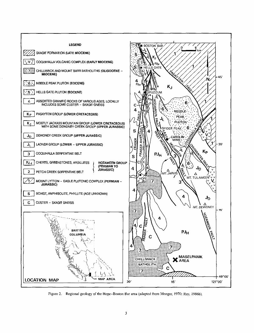
LEGEND
SKAGIT FORMATION (UTE MIOCENE)
COQUIHALLAVOLCANIC COMPLu( (EARLY MIOCENE)
E3 CHlLLlWACKAND MOUNT BARR BATHOLITHS (OLIGOCENE - MIOCENE)
bg NEEDLE PEAK PLUTON (EOCENE)
E? .. HELLS GATE PLUTON (EOCENE]
E] ASSORTED GRANITIC ROCKS OFVARIOUS AGES, LOCALLY INCLUDES SOME CUSTER - SKAGIT GNEISS
Ea PASAYTEN GROUP (LOWER CRETACEOUS)
@J MOSTLY JACKASS MOUNTAIN GROUP (LOWER CRETACEOUS) WITH SOME DEWDNEY CREEK GROUP (UPPER JURASSIC)
DNYDNEY CREEK GROUP (UPPER JURASSIC)
h z LADNER GROUP (LOWER - UPPER JURASSIC)
COQUIHALLA SERPENTINE BELT
CHERTS, GREENSTONES, ARGILLITES HOZAMEEN GROUP
PETCH CREEK SERPENTINE BELT 1 JURASSIC) (PERMIAN TO
E g MOUNT LYTTON - EAGLE PLUTONIC COMPLEX (PERMIAN - JURASSIC)
11 SCHIST, AMPHIBOLITE, PHYLLITE (AGE UNKNOWN)
El CUSTER - SKAGIT GNEISS
3 15' 12
15'
3 0
15'
69000'
IO'
Figure 2. Regional geology of the Hope-Boston Bar area (adapted from Monger, 1970; Ray, 1986b).
3

abandoned Aurum, Pipestem and Emancipation mines. One majorresult of the exploration activity was the opening of the Carolin gold mine, which operated between 1982 and 1984.
The Carolin mine claims (originally called the “Idaho claims”) were first staked in 1915 by T. De Angelis, J. O’Connell and A. McLean. The outcrops of the “Idaho zone”, the gold deposit which later became the Carolin orebody, were originally described by Cairnes (1929). In
zone; they intersected mineralization, averaging 5.4 metres 1945 and 1946, eight shallow diamond-drill holes tested the
wide, grading 5.8 grams gold per tonne. In 1966, trenching by Summit Mining Ltd. extended the surface showings for a strike length of 75 metres. In 1973, the Ladner Creek property was purchased by Carolin Mines Ltd. which con- ducted a major exploration and drilling program and, by the end of 1974, the mining potential of the Idaho zone was realized. Underground diamond drilling and bulk sampling of the zone were carried out from an exploration decline in
design capacity, was completed in 1981 (Plate 1). Milling 1977 and 1978, and the mill, with a 1360 tonne-per-day
Figure 3. The geology adjacent to the Hozameen fault between Stout and the Coquihalla River.
began in December 1981 and the first dorC bar was poured in February 1982. Mining was by open-stope blast-hole methods taking vertical slices from longhole rings placed 1 .5
and milling procedures are given by Samuels (1981). During metres apart. Further details on the initial mining methods
its three years of operation, Carolin mine produced a total of 1354 kilograms of gold from 799 119 tonnes of ore; the annual mining and gold production statistics are given in Appendix 10. Throughout the mining operation there were
cerns and poor gold recoveries. These difficulties.resulted in several periods of shutdown caused by environmental con-
the closure of the mine at the end of 1984.
PREVIOUS GEOLOGICAL WORK The first important geological description of the area was
given by Dawson (1879) who traversed the Coquihalla River
properties in the Swash Creek area (Figure 3), appmx- valley in 1877. Later, Bateman (191 I ) described some gold
imately 7 kilometres east-northeast of Yale, and Camsell (1919), working along the Coquihalla valley, examined some gold properties in the “Ladner slate belt” (now part of the Ladner Group). A major contribution to the geological knowledge of the area was made by Cairnes (1920, 1924,
serpentine belt and the Ladner and Dewdney Creek groups. 1929, 1944) who mapped and described the Coquihalla
Cairnes also described some gold properties in the area, including the Aurum, Emancipation and Pipestem mines.
(1967) described Hozameen Group rocks in the Hope region Both Oshorne (1966) and McTaggart and Thompson
adjacent to the Hozameen fault, while Haugerud (1985) dated these rocks in the Maselpanik area (Figure 2), south of Hope, as being Permian to Middle Jurassic in age on the basis of microfossil evidence.
Hope (west half) map sheet and first named the Needle Peak Monger (1970) completed a geological compilation of the
pluton. The sedimentary rocks in the Methow-Pasayten trough in the Manning Park area southeast of Hope were
tectonic and sedimentation studies on rocks of the Methow- mapped and described by Coates (1970, 1974), and regional
Pasayten trough were subsequently presented by Kleinspehn (1985), Trexler and Bourgeois (1985), and O’Brien (1986a,
tectonism or plutonism of the region include those by Greig 1986b, 1987). Other recent publications relevant to eitherthe
(1989), Whitney and McGroder (1989), Haugerud (1989), McGroder and Miller (1989), Miller et al. (1989) and Haugerud et al. (in preparation).
Following renewed interest in the Coquihalla gold belt in the 197Os, several studies of the Hozameen fault and the associated gold properties were undertaken; these included a three-year mapping project by the British ColumbiaMinistry of Energy, Mines and Petroleum Resources (Ray, 1982,
chemistry of the Carolin gold deposit were described by 1983, 1984, 1986a, 1986b, 1986~). The geology and geo-
Shearer and Niels (1983) and Ray et al. (1986). Other publications concerning either the Hozameen fault, or prop- erties in the Coquihalla gold belt, include those by Cochrane et al. (1974), Anderson (1976), Cardinal (1981, 1982) and Wright ef al. (1982).
4

GENERAL GEOLOGY
REGIONAL GEOLOGY This bulletin describes the geology, geochemistry, miner-
alization and inferred geological history of an area adjacent to the Hozameen fault between Mount Tulameen, approx- imately 20 kilometres east of Hope, and Boston Bar (Figures 2, 3., and 4). In places this structure is associated with ultramafic rocks of the Coquihalla serpentine belt (Cairnes, 1929; Ray, 1984) and with sporadic, but widespread gold mineralization (Ray, 1983) including the Carolin orebody (Shearer and Niels, 1983).
tains physiographic unit (Holland, 1976), at the southern end The Hope-Boston Bar area lies within the Cascade Moun-
of the Coast plutonic complex close to its boundary with the Intermontane Belt. The Hozameen and Pasayten faults (Fig- ure 2) mark the western and eastern boundaries of the northwest-trending Pasayten trough (Coates, 1970) which is a northerly continuation of the Methow basin in Washington State and a probable southeasterly extension of the Tyaughton trough (Monger, 1977, 1985; Kleinspehn, 1985). Turbidite and successor basin sedimentary deposits predominate in the trough; these range in age from Early Jurassic to Middle Eocene (Coates, 1974; Greig, 1989) and have an estimated maximum thickness of between 9000 and 12000 metres (Figure 5B).
plutonic complex (Figure 2) contains deformed remnants of Northeast of the Pasayten fault, the Mount Lycton-Eagle
the Triassic Nicola Group (Monger and Preto, 1972; Preto, 1979) together with both younger and older granitic rocks. Potassium-argon and zircon dates from the complex range from 250 Ma (Monger, personal communication, 1984) to 100 Ma (Monger and Preto, 1972; Monger and McMillan, 1984, Greig, 1989).
Unconformably underlying the Pasayten trough, and for-
the Spider Peak Formation of possible Early Triassic age ming the basement to it, is a volcanic greenstone sequence,
(Ray, 1986a and b). This unit is best developed in the Spider
tinuous strip that generally separates the Ladner Group to the Peak-Coquihalla River area where it forms a narrow discon-
east from the Hozameen fault and Coquihalla serpentine belt to the west (Figure 3).
in Figure 5B. Marine siltstones, argillites and wackes of the The stratigraphy in the Methow-Pasayten trough is shown
Lower to Upper Jurassic Ladner Group are the oldest sedi- mentary rocks in the trough. They rest unconformably on volcanic rocks of the Spider Peak Formation. The upper part of the Ladner Group probably passes laterally across a facies change into marine argillites, tuffs and wackes of the Upper Jurassic Dewdney Creek Group2 (Cairnes, 1924; Coates,
sequmce of coarse clastic, shallow-water marine sediments 1974); these rocks are overlain in turn by a 4000-metre-thick
”
O‘Brien (1986b. 1987) recommends lhat the Upper lurassie rocks of Coates’ Dewdn8:y Creek Group be renamed the Thunder Lake sequence and that the term Dewdmy Creek Formarion be retained for a Middle Jurassic ~ucces~ion of tuffs, Sedimem andnewly recognized volcanies. The discovery, during thin survey. ofupper lurassio foisils within the Ladner Group S U C E ~ S S ~ O ~ at Pipestem mine suggests that the group i i in pan time-equivalent lo the Upper Jurassic Thunder Bay sequence.
of the Lower Cretaceous Jackass Mountain Group. The youngest rocks in the trough include Early Cretaceous, coarse clastic, nonmarine sediments of the 3000-metre-thick Pasayten Group (Coates, 1974), as well as some Middle Eocene sediments (Greig, 1989).
West of the Hozameen fault, the Hozameen Group (Daly, 1912) represents a highly deformed oceanic assemblage of chert, greenstone, argillite, serpentinite and rare limestone (Cairnes, 1924; McTaggart and Thompson, 1967; Monger, 1970, 1975; Ray, 1984, 1986a and b) of Permian to Middle Jurassic age (Haugerud, 1985). Farther west, i t is in fault contact with para- and orthogneisses of the Custer-Skagit gneiss, and granitic rocks that range from 35 to 103 Ma in age
White, 1970; Wanless ef al., 1973; Figure 2). Work by Tabor (Baadsgaard er al. , 1961; Monger, 1970; Richards and
er al. (1989), Haugerud (1989) and Miller et al. (1989) suggests that the protolith of the Custer-Skagit gneiss is in part Triassic, and that the orthogneisses, which make up the bulk of the complex, are largely Late Cretaceous and Early Tertiary in age. Many of the potasium feldspar rich granitic intrusions, including several deformed bodies, are Middle Eocene in age. At or after45 Ma (Middle Eocene) the Custer- Skagit gneiss underwent ductile northwest-southeast exten- sion (Haugerud er a / . , in preparation).
Group and the Custer-Skagit gneiss varies along strike from a The nature of the tectonic contact between the Hozameen
single sharp fault to a wide, poorly defined fracture zone. In northern Washington the contact is represented by the Ross Lake fault (Misch, 1966). while southeast of Hope, McTag- gart and Thompson (1967) noted a “transition zone” marked by a sharp westerly increase in metamorphic grade and migmatization. This zone, which contains at least one fault within sillimanite-grade mcks (Haugerud, 1985), is crosscut and intruded by the Chilliwack batholith dated at 16 to 35 Ma (Richards and White, 1970). Northeast of Hope, easterly dipping mylonites separate the gneisses from the structurally overlying Hozameen Group (Read, 19601, while farther north, east of Hells Gate (Figure 4), the two are in fault contact (Ray, 1984). There, the low-grade Hozameen Group rocks to the east are separated from cataclastic, gar- netiferous, sillimanitebearing gneisses and younger granitic rocks to the west by the east-dipping Petch Creek fault, in which mylonite is developed locally.
The Hozameen fault, which separates the Hozameen Group from the rocks of the Methow-Pasayten trough, is a major, steeply dipping, north-northwest-trending fracture system that exceeds 100 kilometres in length in southwestern
Washington State where it appears to truncate the low-angle British Columbia (Figure 2). To the south, it extends into
Jack Mountain thrust (Taborer al., 1989), and is apparently cut and intruded by the Eocene (50 Ma) Golden Horn batholith (McGroder, 1988, McGroder and Miller, 1989). To the north of the Coquihalla River area the Hozameen fault is
Thompson, 1967; Monger and McMillan, 1984). The north- cut off by the younger Fraser faults (McTaggart and
westerly continuation of the system beyond the Fraser faults is uncertain; McTaggart and Thompson considered its poss-
5

0 UNMAPPED AREAS
NEEDLE PEAK PLUTON (EOCENE] GRANITE AN0 GRANODIORITE
JACKASS MOUNTAIN GROUP (LOWER CRETACEOUS) WITH SOME DEWDNEY CREEK GROUP (UPPER JURASSIC) WACKE AND CONGLOMERATE
SEDIMENTARY ROCKS OF UNCERTAIN AGE POSSIBLY DEWDNEY CREEK GROUP (UPPER JURASSIC ?) WACKE AND SILTSTONE
ARGILLITE. SILTSTONE, MINOR WACKE. AND CONGLOMERATE LADNER GROUP (JURASSIC)
SPIDER PEAK FORMATION (LOWER TRIASSIC ?) GREENSTONE AND GABBRO, RARE SEDIMENTARY ROCKS
MAINLY CHERT I GREENSTONE AND GABBRO
HOZAMEEN GROUP (PERMIAN TO JURASSIC)
PETCH CREEK SERPENTINE BELT
COOUIHALLA SERPENTINE BELT SERPENTINITE AND GABBRO
IAl CUSTER - SKAGlT GNEISS AND YOUNGER INTRUSIVE ROCKS GRANITIC ROCKS
SYMBOLS
GEOLOGICAL CONTACT c____
FAULT - STRIKE AND DIP OF BEDDING: TOPS KNOWN, UNKNOWN 99
OVERTURNED BEDDING " STRIKE AN0 DIP OF GNEISSIC FOLIATION Y
LIMIT OF MAPPING /--._, TYPE SECTION FOR THE SPIDER PEAK FORMATION [SEE FIGURE 3) S'S
\y BOSTON BAR
Figure 4. Simplified geology adjacent to the Hozameen and Petch Creek faults between Boston Bar and Stout
6
ible extension to follow a prominent ultramafic zone exposed approximately 20 kilometres northwest of Boston Bar, while Monger (1985) believes the 300-kilometre-long Yalakom fault.. northwest oflillooet, represents the offset continuation of the Hozameen fault.
The dip of the Hozameen fault varies along strike. In northern Washington it is represented by an original low- angle structure that was subsequently refolded into a synfor- mal feature (Misch, 1951, 1952, 1966). Near the United
farther north, in the Boston Bar-Coquihalla River area, dips States border the fault dips steeply west (Rice, 1947) while
are generally steep to the east. Both Misch, and McTaggart and 'Thompson, suggested that this regional change in atti- tude is due to later refolding of the fracture; this study supports their interpretation.
North of Mount Dewdney (Figure 2), the Hozameen fault encloses the Coquihalla serpentine belt (Cairnes, 1929),
which forms an elongate, steeply dipping ultramafic unit that exceeds 50 kilometres in discontinuous strike length and locally reaches 2 kilometres in outcrop width (Figures 2 and
fractures (Figures 2 and 24), the East and West Hozameen 3). The margins of the belt are sharply defined by two major
faults, which underwent recurrent vertical and horizontal movements (Ray, 1983). At Carolin mine (Figures 2 and 24), the Coquihalla serpentine belt separates the Hozameen Group to the west from rocks of the Spider Peak Formation and Ladner Group to the east. Both to the north and south, however, the ultramafic belt gradually thins until the Hoza- meen and Ladner groups are either in direct fault contact, or are separated by narrow lenses of fault-hounded serpentinite less than 100 metres wide (Figures 3 and 4). With gradual thinning of the serpentine belt, the eastern and western bounding fractures merge into a single tectonic feature, the Hozameen fault (Figure 2).
METRES . 14000 U I U
. 11000
. 11000
. 7000 ' 7000
4000 . 4000
.. 3000
.- 2000
.. 1000
-. 0
B PASAYTEN GROUP 1 LOWER CRETACEOUS]
I JACKASS MTN.GP. (LOWER CRETACEOUS)
NATURE OF CONTACT. UNCERTAIN -c
A
LIMESTONE
ARGILLITE CHERT SILTSTONE
GREENSTONE I c4 GREENSTONE
GREENSTONE
GABBRO
1 E /- SERPENTINITE
1-1
FOSSILIFEROUS WACKE
ARGILLITE
SILTSTONE
WACKE AND CONGLOMERATE
LUNCONFORMITY
HOZAMEEN
SERPENTINITE
DEWDNEY CR. GROUP (UPPER JURASSIC1
1 1 t
K LADNER 3
GROUP ILOWER- UPPER JURASSIC)
rocks and underlying basement in the Coquihalla River area. (Data on the Pasayten, Jackass Mountain and Dewdney Creek groups after Figure 5 . Schematic stratigraphic columns: (A) Hozameen Group succession east of Hells Gate; (B) Pasayten trough sedimentary
Ca.irnes, 1924, 1944; and Coates 1970, 1974).
7
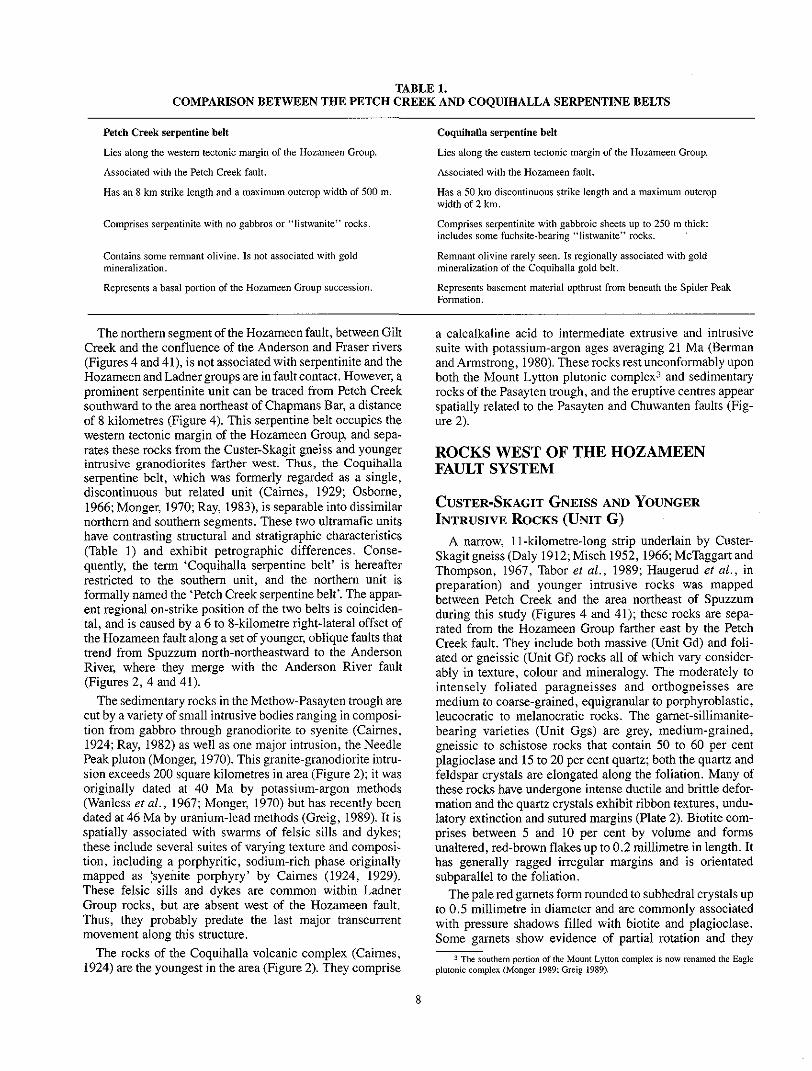
COMPARISON BETWEEN THE PETCH CREEK AND COQUIHALLA SERPENTINE BELTS TABLE 1.
Peteh Creek serpentine belt
Lies along the westem tectonic margin of the Hozameen Group.
Associated with the Petch Creek fault.
Has an 8 km strike length and a maximum outcrop width of 500 m.
Comprises serpentinite with no gabbros or “listwanitc” rocks
Contains some remnant olivine. Is not associated with gold mineralization.
Represents a basal portion of the Hozameen Group succession.
Coquihalla serpentine belt
Lies along the eastem tectonic margin of the Hozameen Group.
Associated with the Hozarneen fault.
Has a 50 krn discontinuous strike length and a maximum outcrop width of 2 km.
Comprises serpentinite with gabbroic sheets up to 250 m thick includes some fuchsite-bearing “listwanite” rocks.
Remnant olivine rarely seen. Is regionally associated with gold mineralization of the Coquihalla gold belt.
Represents basement material upthrust from beneath the Spider Peak Formation.
Creek and the confluence of the Anderson and Fraser rivers The northern segment of the Hozameen fault, between Gilt
(Figures 4 and 41), is not associated with serpentinite and the Hozameen and Ladner groups are in fault contact. However, a prominent serpentinite unit can be traced from Petch Creek southward to the area northeast of Chapmans Bar, a distance of 8 kilometres (Figure 4). This serpentine belt occupies the western tectonic margin of the Hozameen Group, and sepa- rates these rocks from the Custer-Skagit gneiss and younger intrusive granodiorites farther west. Thus, the Coquihalla serpentine belt, which was formerly regarded as a single, discontinuous but related unit (Cairnes, 1929; Osborne,
northern and southern segments. These two ultramafic units 1966; Monger, 1970; Ray, 1983), is separable into dissimilar
have contrasting structural and stratigraphic characteristics
quently, the term ‘Coquihalla serpentine belt’ i s hereafter (Table 1) and exhibit petrographic differences. Conse-
restricted to the southern unit, and the northern unit is formally named the ‘Petch Creek serpentine belt’. The appar- ent regional on-strike position of the two belts is coinciden- tal, and is caused by a 6 to X-kilometre right-lateral offset of the Hozameen fault along a set of younger, oblique faults that trend from Spuzzum north-northeastward to the Anderson River, where they merge with the Anderson River fault (Figures 2, 4 and 41).
The sedimentary rocks in the Methow-Pasayten trough are cut by a variety of small intrusive bodies ranging in composi- tion from gabbro through granodiorite to syenite (Cairnes,
Peak pluton (Monger, 1970). This granite-granodiorite intru- 1924 Ray, 1982) as well as one major intrusion, the Needle
sion exceeds 200 square kilometres in area (Figure 2); i t was originally dated at 40 Ma by potassium-argon methods (Wanless et a!., 1967; Monger, 1970) but has recently been dated at 46 Ma by uranium-lead methods (Greig, 1989). It is spatially associated with swarms of felsic sills and dykes; these include several suites of varying texture and composi- tion, including a porphyritic, sodium-rich phase originally
These felsic sills and dykes are common within Ladner mapped as :syenite porphyry’ by Caimes (1924, 1929).
Thus, they probably predate the last major transcurrent Group rocks, but are absent west of the Hozameen fault.
movement along this structure.
1924) are the youngest in the area (Figure 2). They comprise The rocks of the Coquihalla volcanic complex (Cairnes,
a calcalkaline acid to intermediate extrusive and intrusive suite with potassium-argon ages averaging 21 Ma (Berman and Armstrong, 1980). These rocks rest unconformably upon both the Mount Lyttou plutonic complex3 and sedimentary rocks of the Pasayten trough, and the eruptive centres appear
ure 2). spatially related to the Pasayten and Chuwanten faults (Fig-
ROCKS WEST OF THE HOZAMEEN FAULT SYSTEM
CUSTER-SKAGIT GNEISS AND YOUNGER INTRUSIVE ROCKS (UNIT G )
A narrow, 1 1-kilometre-long strip underlain by Custer-
Thompson, 1967, Tabor et al., 19x9; Haugerud et a l . , in Skagit gneiss (Daly 1912;Misch 1952,1966; McTaggart and
preparation) and younger intrusive rocks was mapped between Petch Creek and the area northeast of Spuzzum during this study (Figures 4 and 41); these rocks are sepa- rated from the Hozameen Group farther east by the Petch Creek fault. They include both massive (Unit Gd) and foli- ated or gneissic (Unit Gf) rocks all of which vary consider- ably in texture, colour and mineralogy. The moderately to
medium to coarse-grained, equigranular to porphyroblastic, intensely foliated paragneisses and orthogneisses are
bearing varieties (Unit Ggs) are grey, medium-grained, leucocratic to melanocratic rocks. The garuet-sillimanite-
plagioclase and 15 to 20 per cent quartz; both the quartz and gneissic to schistose rocks that contain 50 to 60 per cent
feldspar crystals are elongated along the foliation. Many of these rocks have undergone intense ductile and brittle defor- mation and the quartz crystals exhibit ribbon textures, undu- latory extinction and sutured margins (Plate 2). Biotite com- prises between 5 and 10 per cent by volume and forms unaltered, red-brown flakes up to 0.2 millimetre in length. It has generally ragged irregular margins and is orientated subparallel to the foliation.
The pale red garnets form rounded to subhedral crystals up to 0.5 millimetre in diameter and are commonly associated with pressure shadows filled with biotite and plagioclase. Some garnets show evidence of partial rotation and they ~
The southern portion ofthe Mount L y m n complex is now renamed the Eagle plutonic complex (Monger 1989: Greig 1989).
8

usually contain abundant small inclusions of quartz with lesser amounts of plagioclase, biotite and apatite (Plate 3) . The euhedral nature of the small quartz crystals within the garnets contrasts with the anhedral, irregular form of the larger quartz crystals in the rock groundmass (Plate 3). The larger garnets are cut by numerous parallel fractures orien- tated normal to the foliation.
of these rocks and occurs as bundles and sheafs oriented Sillimanite (fibrolite) generally forms less than 2 per cent
subparallel to the foliation and intergrown with the biotite, quartz and feldspar. Accessory minerals include apatite, chlorite, sericite, pyrite, ilmenite and zircon.
The orthogneisses range in composition from quartz monzonite through granodiorite to quartz diorite. The foli-
hornbl.ende andlor 5 to I O per cent biotite, although in the ated granodiorites generally contain 5 to 20 per cent
cent b y volume. The other principal minerals are plagioclase, more mafic varieties these minerals total more than 40 per
potassium feldspar and quartz, with traces of chlorite, epi- dote, apatite, sphene, zircon and opaque minerals. The orighsl porphyritic rocks are now represented by augen or flaser gneisses containing large, flattened plagioclase and potassium feldspar augen up to 1.5 centimetres in length. Many of these augen comprise an older, partially altered core containing deformed twin planes and perthitic textures, rimme:d by numerous small crystals of fresh secondary feldspar and quartz (Plate 2) . Some augen exhibit evidence of partial rotation.
The: granodiorite gneisses outcropping approximately 2.5 kilometres southeast of Hells Gate contain a thin (less than 20 metres) unit of grey, highly deformed marble (Unit Gm) which is at least 300 metres in strike length. Contacts hetwe(:n the marble and the foliated granodiorite are sharp and sheared. In its southern part the marble unit contains numerous pink, angular, deformed, matrix-supported clasts of white to pale pink leucogranite and aplite up to 20 centimetres in diameter (Plate 4).
generally grey to pale pink, massive to weakly foliated The. younger plutonic rocks that intrude the gneisses are
leucocratic rocks ranging from granodiorite to quartz
equigranular and porphyritic varieties, and locally are cut by monzonite in composition (Unit Gd). They include both
randomly oriented aplite veins and dykes.
the Petch Creek fault were subjected to early ductile and later Both the gneisses and younger plutonic rocks adjacent to
brittle movements. Ductile deformation resulted in the for- mation of thin mylonite zones as well as small-scale, rootless isoclinal folds and elongate, ribbon-textured quartz crystals. In some areas immediately adjacent to the fault, ductile movements have transformed the original feldspar- porph:yritic rocks into augen and flaser gneisses (Plate 2). The mylon.ites are well-layered rocks forming hands generally less than 2 metres thick; they consist largely of an exceed- ingly fine grained, granulated, silicified groundmass con- taining occasional larger crystals or trails of relict altered plagioclase, hornblende or epidote.
Several subsequent episodes of brittle deformation along the Petch Creek fault resulted in pervasive cataclasis and the development of mortar textures, faulting and slickensiding. In thin section, brittle deformation is evidenced by the
formation of granulated margins around the larger quartz and feldspar crystals, by the shredding and buckling of biotite, and by the development of incipient microshears around the
postcataclastic silicification and the crystallization of fresh larger hornblende and feldspar crystals. Sporadic
quartz are seen in the groundmass of some previously sheared gneisses.
HOZAMEEN GROUP (UNIT PJH) [INCLUDING THE PETCH CREEK SERPENTINE BELT]
The Hozameen Group in British Columbia is a highly deformed suite of oceanic rocks with metamorphic grades varying from prehnite-pumpellyite to amphibolite facies (Haugerud, 1985; Haugerud personal communication, 1989). It forms an elongate crustal unit more than 20 kilo- metres wide near the International Boundary, but north-
the east the Hozameen Group is bounded by the Hozameen wards, toward Boston Bar, it steadily narrows (Figure 2). To
fault system, while to the west it is faulted against the Custer- Skagit gneiss and various intrusive and schistose rocks
probably a northern continuation of the Ross Lake fault in (Figure 2); this western boundary, the Petch Creek fault, is
Washington State.
Columbia (Figure 2) and Jack Mountain area of Washington The Hozameen Group in the Maselpanik area of British
State contains cherts ranging from Permian to Middle Jurassic in age, as well as basaltic sequences probably erupted during Permian and Late Triassic time (Haugerud, 1985). Farther north, however, between Boston Bar and Mount Tnlameen (Figure 2), the ages of Hozameen Group
extract microfossils from Hozameen rocks in this area have sedimentation and volcanism are unknown; attempts to
been unsuccessful. Hozameen rocks immediately adjacent to the Hozameen fault include highly deformed cherts inter- layered with lesser amounts of greenstone and phyllitic argillite. East of Hells Gate, between Spuzzum and Boston Bar (Figure 4), the sequence attains a thickness of approx- imately 2500 metres (Figure 5A). There are three major divisions: a structurally lower ultramafic unit comprising the Petch Creek serpentine belt (Unit PJHu), a middle mafic unit composed mainly of volcanic greenstone (Unit PJHg), and an upper sedimentary unit in which cherts predominate (Unit PJHc). Despite lack of fossil control, these divisions are tentatively considered to be a tectonically attenuated strat- igraphic succession; they probably represent oceanic layers
Group is believed to be a dismembered ophiolite suite. I , 2 and 3 respectively (Cann, 1974), and the Hozameen
the oldest Hozameen rocks exposed in this area; they form a The Petch Creek serpentinites (Unit PJHu) are probably
continuous unit, 8 kilometres long, with a maximum true thickness of 450 metres (Figure 5A). The serpentinite is exposed in small outcrops along the Trans-Canada Highway just north of Petch Creek, and can he traced southward to an area 5 kilometres northeast of Chapmans Bar (Figures 4 and 41). The belt reaches its maximum thickness at its southern end, where it is truncated by younger north-northeast- trending faults. Continuation southward beyond these faults is unproven, but a narrow serpentinite layer, reportedly exposed along a Canadian National Railway cutting less than 1.6 kilometres north of Stout (Cairnes, 1929), may represent
9

Photomicrograph (X nicols) of augen gneiss with rotated, Plate 2. Ductile deformation in the Custer-Skagit gneiss.
deformed K-feldspar megacrysts within a matrix of ribbon- textured quartz crystals. Sample taken from a biotite- sillimanite-bearing gneiss (Unit Ggs) adjacent to the Petch Creek fault. 2 kilometres east of Hells Gate tunnel.
graph (PPL) of biotite-garnet-sillimanite gneiss with partially Plate 3. Custer-Skagit gneiss (Unit Ggs). Photomicro-
rotated garnet porphyroblast containing abundant inclusions of quartz. plagioclase, biotite and apatite. Sample taken 2 kilometres east of Hells Gate tunnel.
Plate 4. Custer-Skagit gneiss (Unit Gm). Thinly layered, deformed marble containing angular clasts of leucogranite and aplite 2.5 kilometres east-southeast of Hells Gate.
10

an attenuated extension of the belt. The belt generally lies along the westemmost boundary of the Hozameen Group (Figures 4 and 41); it is fault bounded and dips between 40 and 71)" eastward. Along its western margin the serpentinite is marked by intense ductile and brittle shearing; the presence of geeitly plunging mylonitic lineations suggests some major transcurrent movement. This ultramafic belt differs from the Coquihalla serpentine belt farther south (Table I ) in that it contains no gabbroic intrusions, has no regional association with gold mineralization or listwanites, and contains olivine- rich material in which primary igneous textures are recogniz- able (Oshorne, 1966). However, both the Petch Creek and Coquihalla serpentinites are believed to have been largely derive:d from ultramafic cumulates, and there is no evidence that they represent mantle tectonites.
In outcrop, the Petch Creek serpentinites are massive to highly schistose, dark-coloured rocks that locally contain
chrysotile veinlets. Majorrock-forming minerals are serpen- remnant olivine and pyroxene crystals, and are cut by narrow
tine, (olivine, enstatite and bastite with variable but lesser amounts of talc, chlorite and opaque minerals. The olivine content varies from trace amounts up to more than 50 per cent by volume and Osborne (1966) reports that it has a composi- tion of 90 t '2 mol per cent forsterite. It generally occurs as fractured, anhedral crystals, up to I centimetre long, that
tite and other opaque alteration minerals. Locally the serpen- show varying degrees of replacement by serpentine, magne-
tinites contain up to 30 per cent enstatite as anhedral to subhe,dral crystals up to 1.5 centimetres in length that are
enstatite are common, and locally the rocks are enriched in partially altered to bastite. Bastite pseudomorphs after
talc. Other minor constituents include chromite, magnetite, magnesite, chrome spinel, chalcopyrite, millerite, actinolite- tremolite and augite. The chrome spinels are partially altered and surrounded by opaque rims, while the augite occupies exsolution lamellae within the enstatite. Chromite generally forms anhedral to subhedral grains up to 2 millimetres in diameter and Osborne (1966) notes that the proportion of magnetite to chromite increases as serpentinization inten- sifies. Unlike the Coquihalla serpentine belt, no fuchsite- mariposite-hearing listwanites or gabbroic rocks were observed within the Petch Creek serpentine belt (Table I).
contact with, and structurally overlain by, a thick sequence of To the east, the Petch Creek serpentine belt is in fault
greenstone which forms the middle unit of the Hozameen Group (Figure 5A). This unit has an average thickness of 500 metres (Figure 5A), hut east of Chapmans Bar (Figure 4) it is more than 1100 metres thick. It consists largely of altered, black to light green basaltic greenstones (Unit PJHg) with 5:ome gabbro (Unit PJHG) toward the base; contacts between the greenstones and the gabbroic rocks are generally gradational. The greenstones are typically massive, but rare pillowed structures are present near the top of the unit. Locally, southwest of Hells Gate, the greenstones contain thin tmectonic slices of serpentinite generally less than 25 metres thick.
on the degree of alteration. The freshest contain between 25 The mineralogy of the greenstones is variable, depending
to 50 per cent augite which generally forms anhedral, par- tially altered crystals up to 1.0 millimetre in diameter. Ophitic textures are common and the plagioclase laths reach
0.3 millimetre in length and are highly altered to clinozoisite,
rocks is difficult to determine due to the ubiquitous altera- zoisite and chlorite. The plagioclase composition in these
tion, although oligoclase-andesine (Anz5.& and some minor secondary albite were recorded. Tremolite-actinolite, which
volume, often rims and replaces the augite crystals. is widespread and forms up to 40 per cent of the rock by
Accessory minerals include quartz, skeletal ilmenite, epi- dote, carbonate, sphene, apatite, pyrite and magnetite. Osborne (1966) reports the presence of stilpnomelane in the greenstones in the Gilt Creek area. Many of these rocks are cut by irregular veins of black, highly sheared chlorite and veinlets of weakly altered, finely twinned albite.
lies the Petch Creek serpentine belt, greenstone flows up to In addition to the major greenstone sequence which over-
200 metres thick are present higher in the Hozameen Group succession (Figure 5A); these are most common northeast and southeast of Hells Gate Mountain where they are inter- layered with cherts and argillites. Despite alteration and
amygdules. One volcanic flow outcropping 4 kilometres shearing, they exhibit remnant pillow structures and some
south-southeast of Hells Gate Mountain is unique in being dark maroon to brick-red in colour and possessing possible
This rock is characterized by altered plagioclase laths (An,,) accretionary lapilli features, suggesting a subaerial origin.
up to 0. I millimetre long, some of which are deformed and bent. The ferromagnesian minerals in the groundmass are completely replaced by chlorite and opaque minerals, and the rocks are cut by abundant calcite veins.
Whole-rock and trace element analyses on 16 greenstone samples (Unit PJHg) collected from the Hozameen Group (Appendix 1) indicate they represent a geochemically hetero- geneous, subalkaline basaltic suite (Figures 6A, 7B and 9B) with a wide variation in titanium content. Various plots were made to establish the environment of the Hozameen volca- nism (Figures IOB, IIA, I IB, 12B, 13B, 14B and 15B) which is believed to include two geochemically distinct
boundary hasalts (Figure IOB); the latter possess some arc volcanic suites represented by within-plate and plate-
affinities (Figures I IA, I IB, 12B, 13B and 14B). The within-plate suite is interpreted to be basalt developed in an oceanic island-seamount environment, while discriminatory plots for the nine samples outlined as plate-boundary rocks on Figure IOB suggest that they represent island arc tholeiites (Figures 11A and I IB).
seamount basaltic samples in the Hozameen Group were It i s noteworthy that the arc tholeiites and ocean island-
collected from two different areas. Arc tholeiite samples predominate in the area northeast of Spuzzum and along Gilt Creek, while the seamount-type basalt samples are most common along Hidden Creek (Appendix 1 ; Figure 4). Although the stratigraphic position of some Hozameen greenstones sampled in this study is uncertain, the tholeiitic arc samples (GR 316, 330, 331, 332 and 342; Appendix I ) were collected from the thick greenstone unit that imme- diately overlies the Petch Creek serpentine belt (Figure 5A), while the within-plate basalt samples (GR 338,339,340, and
higher in the sequence. This geochemical bimodalism in the 341; Figure 10B) were taken from flows within the cherts
Hozameen Group, which has also been noted by Haugerud (1985), may reflect sampling of two different stratigraphic
11

units represented by arc tholeiites in the lower part of the sequence and ocean island or seamount basalts higher in the succession. The wide-ranging titanium values in the Hoza- meen volcanic rocks resemble those determined from green- stones in the Bridge River complex, approximately 125 kilomeues northwest of Boston Bar (Potter, 1983). Monger (1977, 1985) and Haugerud (1985) correlate the Hozameen
0
0.1 0.2 0.3 0.4
Hozameen Group greenstones; (B) Spider Peak Formation Figure 6. Triaxial oxide plots (after Church, 1975): (A)
greenstones; (C) gabbroic rocks within the Coquihalla ser- pentine belt.
A 60-
56- - ? - 5 52-
48-
44 -
SPIDER PEAK FORMATION (10SAMPLESI
ANDESITE
HOZAMEEN GROUP 116 SAMPLES) I .'
Figure 7. Plots of SiO, versus log ZriTiO, (after Floyd and Winchester, 1978) illustrating the subalkaline basalt composition of the Spider Peak Formation (A) and Hozameen Group (B) volcanic rocks.
L
ALKALINE 1 I
/ THOLEIITIC
0.05 0.1 0.35 0.2
ZdP*O,
SPIDER PEAK FORMATION (10 SAMPLES). . . . . . . . . .. AVERAGE VALUE FOR PLOT. . . . . . . . . . . . . . . . . . .+
Winchester, 1973, illustrating the tholeiitic character of the Figure 8. Plots of TiO, versus ZriP,O, (after Floyd and
Spider Peak Formation greenstones.
12

4
/a*+@- IlOSAMPLESI ......
SPIDER PEAK FORMATION ......._ AVERAGE OF 10 SAMPLES ....... + HOZAMEEN GROUP .............. A AVERAGE OF 16SAMPLES ....... A
0 0.5 1 0 1.5 % K.0
X
X AVERAGE OF 13 GABBRO \ SAMPLES FROM THE
I. \\
COWJIHPUASERPENTINE a/' BELT ............................... + . . . .. . - - " ." . . "
0 X K20
lb 1:5
1968; Irvine and Baragar, 1971) illustrating the differences Figure 9. (A, B) Alkali-silica plots (after MacDonald,
between greenstones in the Spider Peak Formation (A) and
Formation fall in the alkali field as a result of spilitization. (C) Hozameen Group (B). The volcanic rocks in the Spider Peak
Sodium-potassium plots illustrating the different Na,OlK,O fields determined for greenstones in the Spider Peak Forma- tion (dots) and Hozameen Group (triangles). (D) Sodium- potassium plots of gabbroic rocks (dots) from the Coquihalla
Formation greenstone field and dissimilarity to the Hoza- serpentine belt illustrating their similarity to the Spider Peak
meen Group greenstone field. Note their enrichment in Na,O and depletion in K,O compared with "average" gabbroic rocks as determined by Le Maitre (1976).
I 1
I A SPIDER PEAK FORMATION
SPIDER PEAK FORMATION 110 SAMPLES). . . . . . . . . .e HOZAMEEN GROUP I16 SAMPLES] . . . . . . . . . . . . . .A AVERAGE VALUE FOR EACH PLOT, . . . . . . . . . . . . . .+
1975). The Spider Peak Formation (A) comprises "plate- Figure 10. Plots of ZrIY versus TiiY (after Pearce,
boundary basalts", whereas the Hozameen Group volcanic rocks (6) include both "within-plate" and "plate-boundary basalts". Numbers refer to Hozameen Group sample num- bers listed in Appendix 1.
Group and Bridge River complex on lithological grounds; the similar titanium geochemistry of the volcanic rocks in both areas lends support to this correlation.
The gabbros (Unit PJHG) associated with the greenstones (Unit PJHg) are massive, medium to coarse-grained rocks with a maximum grain size of 2.5 millimetres; most are intensely altered although ophitic textures are recognizable. They mainly comprise strongly altered plagioclase, hornblende, tremolite-actinolite and chlorite with variable amounts of clinozoisite, epidote, augite and carbonate. Accessory minerals include sphene, apatite, magnetite and pyrite and some outcrops are cut by veins of chlorite.
5A) is 1600 metres thick and is dominated by deformed The'upper part of the Hozameen Group succession (Figure
cherts (Unit PJHc) (Plate 5) interlayered with thinner bands of argillite (Unit PJHa), greenstone (Unit PJHg), strongly altered volcaniclastic rocks (Unit PJHs) and limestone or
13

B 10 000 -
- - E, a c
.34* ,
1000 I I I 100
CrlPPml ,000
SPIDER PEAK FORMATION I10 SAMPLES]. . , . . . . . . . HOZAMEEN GROUP 19 SAMPLES) , . . . , , , . . . . . , , I
Cann, 1973; Garcia, 1978); (B) Plots of Ti versus Cr (after Figure 11. (A) Plots of TiO, versus Zr (after Pearce and
Pearce, 1975) illustrating the ocean-floor basalt character of the Spider Peak Formation greenstone (dots) and the arc tholeiitic character of the Hozameen Group (trianges). Num- bers refer to the Hozameen Group “plate-boundary basalts” sample number shown in Figure 10B.
marble (Unit PJHI). Cherts are dark to very light grey to cream in colour and vary from massive to well-layered ribbon cherts; the latter comprise beds between I and 10 centimetres thick separated by thin interlayers of schistose argillite gener- ally less than 0.5 centimetre thick (Plate 5) . In thin section the cherts are seen to consist mostly of an exceedingly fine grained mosaic of quartz crystals and chalcedony, with minor amounts of sericite and chlorite. Sporadic traces of feldspar, magnetite, biotite and carbonate, pyrite and pyrrhotite, and fine-grained carbonaceous materials are also present. Crosscutting quartz veins are common.
Argillites are common in the upper part of the succession, and are often interbedded with the cherts as layers generally less than 25 metres thick. The argillites are strongly deformed and bedding is rarely seen. However, some hori- zons contain deformed; dark, argillitic clasts up to 5 cen- timetres in diametei which are presumed to represent sedi- mentary clasts. Argillites in the Hozameen Group are medium-grained, well-cleaved rocks that vary from slaty to phyllitic in appearance. They comprise mainly fine-grained quartz, chlorite and altered plagioclase, with lesser, variable amounts of sericite, biotite, calcite, prehnite, pumpellyite,
tremolite-actinolite and hornblende. Traces of epidote,
horizons contain graphite. sphene, albite and pyrite or pyrrhotite are seen and some
Marbles and limestones are extremely rare in the Hoza- meen Group in the Hope-Boston Bar area; they are mostly confined to an area approximately 5 kilometres southeast of Hells Gate, apparently within the upper part of the Hozameen
20 metres thick that are interbedded with the cherts and succession (Figure 5A). They generally form layers less than
argillites. In outcrop they are grey, massive to finely layered, intensely sheared and cleaved rocks. The well-foliated out- crops commonly exhibit a mineral lineation and locally these rocks are intensely fractured and cut by calcite veins. The veins comprise over 90 per cent carbonate which forms mostly small, fresh crystals up to 0.2 millimetre in diameter, with some coarser crystals up to I millimetre in length. Accessory minerals include quartz, chlorite, sericite, pla- gioclase and sporadic traces of graphite. The intense defor-
Ti/100
SPIDER PEAK FORMATION 10 SAMPLES
Ti/100
A HOZAMEEN GROUP
B / \ 16SAMPLES /@:I ... .
A+B=ISLANDQRCTHOLEllTES
B+C=CALCALKALINE BASALTS B=OCEAN-FLOOR BASALTS
D=WITHIN-PLATE BASALTS
(A) Spider Peak Formation greenstones; (B) Hozameen Figure 12. Zr-Ti-Y ternary plots (after Pearce, 1975);
Group volcanic rocks.
14

7 8 9 10 11 12 13 14 15 % F ~ O T
B
. 0.0 I / I / / I I
7 8 9 10 11 12 13 14 15 %FeOi
Figure 13. PlotsofTiO,versustotaliron(afterdeRosen- Spence. 1976): (A) Spider Peak Formation greenstones; (B) Hozameen Group volcanic rocks.
A
= Spider Peak Formation, B = Hozameen Group green- Figure 14. A1,0, minus Na,01Ti02 frequency plots A
stones, C&D = Oceanic volcanic and island arc volcanic rocks respectively (after Grasso, 1968).
SPIDER PEAK FORMATION I10 SAMPLES1
i ,
15000 -
- : 10000 - - .. r
5000 - ,,,(/m CALCALKALINE
A312 .212 .251
0 50 100 150 2. lPPrnl
10ZAMEEN GROUP PLATE.BOUNDARY BASALTSI9SAMPLESl. . , . . . . , . . . . , . , A WITHIN-PLATE BASALTS 16 SAMPLESIkGR341 EXCLUDED. , . . . . O
Figure 15. TiO, versus Zr plots (after Pearce and Cann,
greenstones; (B) = Horameen Group greenstones. Numbers 1971, 1973; Muller, 1980); (A) = Spider Peak Formation
refer to Sample Numbers in Appendix I .
deformed by D, folds. 200 metres northeast oftheconfluence Plate 5 . Hozameen Group (Unit PIHc). Ribbon cherts
of the Coquihalla River and Sowaqua Creek.
15

mation that affected these rocks is apparent in thin section; folded calcite twin lamellae and kinked, transposed bedding are commonly observed. Numerous samples of Hozameen limestone, marble and chert from throughout the area were collected for radiolarian dating and conodont identification hut attempts to extract microfossils were unsuccessful (M.J. Orchard, personal communications, 1983, 1984).
Group cherts are interlayered with a heterogeneous rock suite East and northeast of Hells Gate Mountain the Hozameen
(Unit PJHs) whose origin and protolith are uncertain due to the intense deformation and alteration. This unit, which is believed to include metamorphosed volcaniclastic rocks, aquagene breccias, immature siltstones and possibly thin greenstone volcanic flows, forms bands up to 200 metres thick. Some highly altered outcrops of greenstone and vol- caniclastic rock contain angular pods of marble up to 30 centimetres across; these probably represent clasts within gravity slide deposits. Most of the rocks in Unit PJHs are light to dark green, well cleaved, strongly foliated and intensely altered. Remnant bedding and layering areapparent locally and flattened lithic clasts up to 2 centimetres long are seen in some volcaniclastic rocks. In thin section these rocks are seen to comprise mainly chlorite, tremolite-actinolite, strongly altered plagioclase and lesser amounts of quartz. Accessory hornblende, sericite, epidote, carbonate and sphene are also present.
McTaggart and Thompson (1967) identified a 6000-metre stratigraphic sequence in the Hozameen Group southeast of Hope which may be partly correlative with the succession recognized further north in the Boston Bar-Spurzum area (Figure 16). The southern sequence comprises four strat- igraphic units (Figure 16B), the upper three of which, although thicker, may be stratigraphic equivalents of the upper two units distinguished in the Boston Bar-Spuzzum
that in the area southeast of Hope, Unit 1 of McTaggart and area (Figure 16A). If this correlation is correct, it suggests
Thompson (op. cir . ) may not represent the lowest member of the Hozameen Group succession, but may instead be a down- faulted slice of Unit 4 (Figure 16B).
A B
Figure 16. A comparison between the Hozameen Group stratigraphy in the Boston Bar-Spuzzum area (A) and in the area southeast of Hope (B).
MINOR INTRUSIONS IN THE HOZAMEEN GROUP Compared to rocks east of the Hozameen fault, minor
They include sills and dykes of feldspar quartz porphyry intrusions are relatively uncommon in the Hozameen Group.
(Unit F), basic to intermediate rocks (Unit d) and rare quartz veins (Unit Q).
The feldspar quartz porphyries generally form narrow sills and dykes less than 25 metres thick, although one body exposed 800 metres southwest of Spider Peak apparently exceeds 100 metres in outcrop width. They are mostly confined to Hozameen Group rocks between the Coquihalla River and Bijon Lake (approximately 5 kilometres north of Siwash Creek) and are not found east of the East Hozameen fault. Thus, they apparently predate the major transcurrent movement along this structure. Some feldspar quartz por- phyry sills have siliceous, equigranular chilled margins, but many bodies have faulted contacts and are strongly fractured and weakly cleaved.
old railway line 1.6 kilometres north-northeast of the Samples from a quartz porphyry sill outcropping on the
Coquihalla River-Sowaqua Creek confluence were collected for dating by K-Ar and U-Pb methods. However, the exten- sively chloritized mica and scarcity of zircons meant that no analyses were possible.
to medium-grained leucocratic rocks that weather to a cream, In outcrop, the feldspar quartz porphyries (Unit F) are fine
buff or very pale grey colour. Most are porphyritic and characterized by large phenocrysts of quartz and/or feldspar up to 3 millimetres in diameter. In some cases the phe- nocrysts are preferentially concentrated toward the centre of the sills. The fine-grained ophitic-textured groundmass com- prises interlocking quartz and feldspar crystals less than 0.2 millimetre in length. The large quartz phenocrysts vary from subhedral and hexagonal, to rounded, partially resorbed and heavily embayed crystals surrounded by reac- tion rims consisting of exceedingly fine grained quartz and feldspar intergrowths. The quartz phenocrysts are generally clear, strained and cracked, and may contain inclusions of fresh, radiating muscovite with some feldspar. The euhedral to subhedral feldspar phenocrysts include cloudy twinned sanidine with abundant coarse perthitic textures and minute inclusions, as well as finely twinned oligoclase (An,,) crys- tals. The groundmass contains both cloudy potassium feld- spar and lesser amounts of andesine (An34). Other trace and accessory minerals include biotite, sericite, sphene, zircon, epidote and chlorite; chlorite is largely replacing biotite.
rare in the Hozameen Group; most form thin, sheared sills, Minor intrusions of gabbroic to dioritic composition are
but one crosscutting dyke, 8 metres wide with preserved
approximately 3 kilometres south of the Coquihalla River intrusive contacts, outcrops in the Sowaqua Creek valley,
(Figure 40B). The steeply dipping dyke intrudes an east- striking faulted contact between chert and argillite units. The centre of the dyke is massive and medium grained, and contains rare, anhedral plagioclase phenocrysts up to 0.5 centimetre long. Faint layering is seen subparallel to the locally preserved chilled margins, and the adjacent argillites
weakly sheared. In thin section this late dyke is seen to show evidence of weak thermal alteration. Some margins are
16

comprise 60 to 70 per cent interlocking laths of fresh andesine-labradorite (An45.60) up to 0.5 millimetre in length which are intergrown with augite crystals that make up between 20 to 30 per cent of the rock. The augite is weakly altered to, and rimmed by, tremolite-actinotite and chlorite. The larger feldspar phenocrysts are cloudy and partially altered. Accessory and trace minerals include biotite, hornblende, pyrite, magnetite, ilmenite and sphene.
Irregular, thin, quartz-filled tension veins are fairly com-
numerous easterly striking quartz veins crosscut the ribbon mon in cherts adjacent to the East Hozameen fault, and
cherts approximately I kilometre north of Siwash Creek. However, none of the veins contain sulphides and they do not appear to be of economic interest.
exposed in an old rock trench approximately 2.5 kilometres One northerly striking quartz vein, 2 metres wide, is
north-northeast of Alexandra Bridge (Figure 41B). The vein cuts sheared, altered greenstone and gabbroic rocks of the Hozarneen Group, approximately 200 metres east of the Petch Creek fault and contains veinlets and disseminations of pyrite and minor pyrrhotite: assays of sulphide-rich grab samples show it is barren of gold.
ROCKS WITHIN THE HOZAMEEN FAULT SYSTEM (COQUIHALLA SERPENTINE BELT - Unit U)
The Coquihalla serpentine belt is enclosed by the Hoza- meen fault system over a 50-kilometre strike length extend- ing from Mount Dewdney northward to the vicinity of Spuzzum (Figure 2). At its northern and southern ends the belt comprises a discontinuous string of nanow serpentinite lenses, generally less than 100 metres wide, within the Hozameen fault zone. Between Spider Peak and the Mount Jarvis, however, the belt forms a continuous, steeply dipping unit that exceeds 2 kilometres in outcrop width in the Coquihalla River area (Figures 2, 3, 24 and 40). Dark, strongly sheared to massive serpentinites (Unit Us), of pre- sumed peridotite and dunite parentage, characterize the belt (Plate 6). However, in its widest section it also contains a substantial proportion of coarse to fine-grained intrusive rocks (Unit Ug; Figure 40) of gabbroic composition (Figure 6C) as well as minor amounts of magnesite-rich, fuchsite- bearing quartz-carbonate (listwanice) rock (Unit Um).
sharply delineated by the East Hozameen fault (Figures 2, The eastern margin of the Coquihalla serpentine belt is
Plat,: 6 . Coquihalla serpentine belt. Dark serpentinite (Unit Us) containing tectonic boudin of light-coloured microgabbro (Unit GI. Approximately 800 metres southeast of the Idaho zone, Carolin mine.
17

24,40 and 41; Plate 7) which, due to its proximity to many gold occurrences, has been mapped and studied in detail (Cairnes, 1929; Cochrane et al., 1974; Anderson, 1976;
The fault is poorly exposed and usually lacks topographic Cardinal, 1981;Ray, 1982, 1983, 1984; Wrighteral., 1982).
exhibits an undulating character (Cairnes, 1929; Cardinal, expression. It generally dips steeply eastward, but locally
1982) and may reverse attitude to a westward dip. The fault zone comprises several generations of oblique, intersecting fractures which may account for the varying degree of shearing and alteration along the system. Locally, it is sharply defined and unaltered [Plate 7), but elsewhere i t is occupied by a band of sheared talc several metres in width (Cairnes, 1929; Cardinal, 1982).
The western margin of the serpentine belt, the West
subvertical fracture that has greaterregional structural impor- Hozameen fault (Figures 2, 24, 40 and 41), is a major
lance than its eastern counterpart. Hozameen Group rocks close to the serpentine belt show signs of increased deforma- tion, slickensiding, silicification and elongate, subhorizontal
to the fault contain thin layers of talc and minor amounts of mullion structures, while serpentinites immediately adjacent
poor-quality nephrite.
SERPENTINITE (UNIT Us) These rocks, which were first described in detail by
Cairnes (19291, are best developed in the Coquihalla serpen- tine belt south of Spider Peak (Figures 2 and 3) and are particularly well exposed in the area between the Carolin mine and Serpentine Lake (Figure 40). Fresh rocks vary from light green to black in colour, but weathered surfaces are light grey, yellow or brown. Texturally they vary from massive to intensely schistose and sheared (Plate 6). Some outcrops comprise a densely packed mass of shear polyhedrons (Chidester er al., 1951) comprising irregular, spheroidal, pillow-like masses up to 2 metres in diameter, that are separated from one another by thin layers of intensely sheared serpentinite. The shear polyhedrons have highly polished surfaces that locally show irregular slickensiding.
Most serpentinites in the Coquihalla belt are massive, but locally they contain either wholly altered phenocrystic pseudomorphs after olivine and pyroxene, or are speckled with light-coloured carbonate clots up to 4 millimetres in diameter; textures suggest that most of these rocks were derived from ultramafic cumulates. Thin, irregular veinlets of chrysotile and talc cut some outcrops, particularly toward the more sheared eastern and western margins of the belt.
Plate 7. East Hozameen fault. Exposed easterly dipping faulted contact between serpentinites of Coquihalla serpentine belt (Unit Us) to the right, and Ladner Group wackes and siltstones (Units JLw and JLs) to the left. Approximately 800 metres southeast of the Idaho zone, Carolin mine.
18

lamelhr antigorite, bastite and massive lizardite with only In thin section the serpentinite is seen to consist largely of
trace amounts of chrysotile. Antigorite generally comprises
pseudomorphs after olivine up to 3 millimetres in length. between 50 and 95 per cent of the rock, forming
Many of the pseudomorphs are rimmed with fine trails of magnetite and chromite which produce a reticulate network outlining the original olivine crystals. Some sections contain rounded clots of dark brown, pleochroic carbonate which overgrow the antigorite crystal boundaries. Many bastite pseudomorphs after enstatite contain abundant elongate clus-
pyroxene cleavages. Other trace or accessory minerals ters of opaque minerals arranged parallel to the original
includ,e tremolite-actinolite, hornblende, epidote, chlorite, hematte and some skeletal ilmenite. Traces of relict enstatite are seen occasionally, but unaltered olivine remnants are extremely rare.
Major and trace element analyses of serpentinite samples collected from throughout the belt are shown in Appendices 2A and 2B. Although i t is not possible to determine the precise origin of a serpentinite from its chemical composition
nickel content in the Coquihalla serpentinites (Appendix (Pirsson and Knopf, 1966) the relatively high chromium and
2A), compared to those of metasedimentary origin, indicates they were derived from ultramafic igneous rocks.
In the Carolin mine-Coquihalla River area the serpen- tinites are locally cut by very pale green to yellow-coloured,
fine-g:rained dykes are commonly deformed and broken up strongly altered dykes up to 2 metres wide; these massive and
ophitic textures are visible, hut the original feldspar laths are into pods within the serpentinite. In thin section, remnant
completely replaced by fine-grained carbonate and minor sericite, and the mafic minerals are altered to carbonate, chlorite, epidote, clinozoisite and minor opaque minerals. An analysis of a single sample of this rock, from a dyke that intrud'es the serpentinites near Carolin mine, is shown in Appendix 3. It is not known whether these rare, pale dykes
Ug) found elsewhere in the Coquihalla serpentine belt. within, the serpentinite are related to the gabbroic rocks (Unit
green-coloured, strongly altered rocks that are locally cut by
coloured feldspar. At one location approximately 2 kilo- irregular veins of either carbonate, quartz or cream to buff-
gabbroic rocks are intruded by numerous northerly trending metres south-southeast of Spider Peak, very coarse grained
dykes of fine-grained greenstone generally less than I metre wide. Contrary to reports by Anderson (1976), no sheeted dykes were seen in the Coquihalla serpentine belt, and neither was igneous layering identified in any of the gabbros.
In thin section the gabbroic rocks are generally seen to comprise between 20 and 60 per cent plagioclase and 20 to 40 per cent amphibole, with variable amounts of chlorite, epi- dote and carbonate. AI1 show varying degrees of alteration; the finer grained intrusives are often totally altered to a mixture of chlorite, clinozoisite, actinolite, carbonate and epidote. Ophitic textures are recognizable in the coarser grained rocks and the poorly twinned, locally zoned, plagio- clase (An34.5,,) grains reach 2 millimetres in length. They are partially replaced by clusters and intergrowths of epidote, clinozoisite, carbonate and sericite. Generally the pale green hornblende is moderately altered to chlorite, tremolite,
tremolite intergrowths envelope small corroded remnants of actinolite and epidote. In some sections the hornblende-
strongly altered augite. Other trace to accessory minerals include magnetite, ilmenite, sphene, apatite and quartz. The skeletal ilmenite is rimmed with sphene and leucoxene.
Analytical results for samples collected from the mafic
data (Figure 6C) demonstrate the gabbroic composition of the intrusive rocks are presented in Appendix 4. Plots of these
rocks, while Figure 9D shows they are enriched in sodium and depleted in potassium as are the greenstones in the Spider Peak Formation (Figure 9C). As the gabbroic rocks in the belt are considered to be the feeders for the Spider Peak green- stones, i t suggests that either the volcanism was intrinsically sodic or that the spreading-ridge system that gave rise to tiie Spider Peak Formation was affected by very deep level spilitization.
FUCHSITE-BEARING OUARTZ CARBONATE
G A B B R O , MICROGABBRO A N D MINOR GREIENSTONE (UNIT UG)
ROCKS (LISTWANITE)(UNIT U M ) Although boulder float of this distinctive rock type is
widespread in the Spider Peak-McMaster Lake area, it C~OPS The Coquihalla serpentine belt between Mount Tulameen out at only a few separate localities throughout the
and Spider Peak (Figures 2 and 40) contains substantial Coauihalla sementine belt. usuallv in tectonic slices within . - amounts of mafic intrusive rock of gabbroic composition (Appmdix 4; Figure 6C). These rocks form elongate tectonic boudins, sheets, lenses and highly disrupted dykes within the ultramafics, and vary from a few metres (Plate 6) to 250 metre:$ in width and up to 750 metres in strike length. Contacts between the gabbroic and ultramafic rocks are usually faulted, and the serpentinite adjacent to the gabbro sheets is strongly schistose and sheared. However, the local presence of remnant chilled margins suggests the gabbroic rocks intrude the serpentinites. Texturally the gabbroic rocks range from coarse to fine grained, and many of the finer grained varieties are indistinguishable both in appearance
Formation. Nevertheless, all of these rocks in the Coquihalla and geochemistry from the greenstones of the Spider Peak
sive in origin. In outcrop they are massive, dark grey to serpentine belt are believed to be intrusive rather than extru-
or kunediatel; adjacent to the East Hozameen fault. The largest of these slices is situated 700 metres south-southeast of Spider Peak and is approximately 600 metres in strike length and up to 100 metres wide (Figure 40A). The other slices are much smaller; one of them lies on strike and
where it forms a sliver, 5 to 15 metres wide, within the East 100 metres southeast from the Murphy gold occurrence
Hozameen fault zone. Another thin fuchsite-bearing quartz- carbonate unit lies within the Hozameen fault, about 2 kilometres north of its intersection with Siwash Creek (Figure 40A). In addition to these outcrops, abundant large angular boulders of this rock type, presumably derived from a nearby unexposed source, are seen close to the East
McMaster Pond, and northwest of the McMaster zone gold Hozameen fault approximately 300 metres southeast of
occurrence (Figure 36).
19

to medium-grained rocks are generally pale grey or green in Fresh surfaces of these massive to weakly foliated, coarse
colour, and are characterized by sparse disseminations and rare, thin veinlets of the bright green chromium mica, fuchsite (Plate 8). Weathered surfaces are soft, rotted and characterized by a distinctive medium to dark yellow-brown hue (Plate 9). Locally, these rocks are cut by a dense, irregular network of thin white quartz veins, some of which appear to be either folded, or occupying sigmoidal tension fractures. Most of these rocks are strongly deformed and sheared, with the shear planes containing abundant talc and minor fuchsite.
70 per cent medium to coarse-grained carbonate and up to Thin sections show the matrix of the rocks comprises 30 to
50 per cent quartz, 5 per cent plagioclase and lesser amounts of chlorite ( I to 3 per cent), fuchsite (trace to 2 per cent) and opaque minerals. The carbonate is mainly magnesite with only minor amounts of calcite, and mostly forms a mosaic intergrown with the quartz crystals.
Urn). Fuchsite-bearing quartz-magnesite rock crossed by late Plate 8. Coquihalla serpentine belt. “Listwanite” (Unit
quartz veins. Boulder float, 150 metres northwest of the McMaster Zone.
Plate 9. Coquihalla serpentine belt. “Listwanite” (Unit Um). Highly weathered fuchsite-bearing quartz-magnesite rock crossed by deformed quarts veins. Approximately 600 metres south-southwest of Spider Peak.
coarser (up to 2 millimetres) crystals in the crosscutting Both the finer grained quartz crystals in the matrix and the
quartz veins show evidence of intense strain, such as undulat-
fuchsite forms small, pale green, deformed flakes that are ing extinction, deformation lamellae and tension cracks. The
partially altered to chlorite. Fuchsite occurs either as thin irregular veinlets, as flakes surrounding the opaque min- erals, or as radiating clusters within the quartz-magnesite groundmass. The opaque minerals include ilmenite and
fault slice located 2 kilometres north of Siwash Creek are magnetite. Two analyses of rocks collected from the small
shown in Appendices 5A and 5B. The relatively high magne- sium and carbon dioxide values reflect the abundance of
gest the presence of arsenopyrite, although it has not been magnesite. The elevated arsenic values (Appendix 5B) sug-
identified in the field.
ROCKS EAST OF THE HOZAMEEN FAULT SYSTEM
SPIDER PEAK FORMATION (UNIT TV) The Spider Peak Formation was first described and for-
mally named by Ray (1986b) after the prominent hill approx-
40A). The formation, which mainly comprises greenstone, is imately 5 kilometres northwest of Carolin mine (Figure
traceable for more than 15 kilometres along the eastern side of the East Hozameen fault. It generally forms a narrow discontinuous belt separating the Ladner Group from the Coquihalla serpentine belt (Figure 24) and is best developed around Spider Peak where it has an estimated maximum stratigraphic thickness of 500 metres; elsewhere, however, it is generally less than 300 metres thick. Its contact with the Coquihalla serpentine belt is invariably faulted, while an unconformable relationship exists between the formation and the stratigraphically overlying Ladner Group. In the Carolin mine area (Figure 42) the Ladner Group contains two elon- gate, fault bound units of Spider Peak Formation that are interpreted to represent thrust slices.
Emancipation mine and 1.5 kilometres east-northeast of The type section, exposed 6 kilometres south-southeast of
Serpentine Lake, is approximately 250 metres thick (Figure
east and its stratigraphic base to the west is faulted against 3, section S-S’). At this locality the formation dips steeply
The bottom of the formation consists of approximately serpentinites and gabbros of the Coquihalla serpentine belt.
50 metres of massive, medium to coarse-grained gabbro (Unit TVg). This is overlain by 200 metres of both massive
containing deformed pillows between 0.3 and 1.3 metres in (Unit TVm) and pillowed greenstone (Unit TVp), the latter
diameter. Near the top of the section, areas between individ- ual pillows contain volcaniclastic sedimentary material and sporadic angular chert fragments. Some thin beds of aqua- gene breccia (Unit TVb) and immature volcanic sandstone (Unit TVs) are also present. The stratigraphic and structural top of the section is marked by the basal conglomerate of the Ladner Group; at this locality the conglomerate is between 1 and 5 metres thick and contains deformed, elongate clasts of
timetres in length. greenstone and black to grey-banded chert up to 20 cen-
20

overlies the Ladner Group in the Carolin mine area (Fig- The Spider Peak Formation is inverted and structurally
ure 42), but north and south of the mine tectonic inversion becomes less common. North of Spider Peak, the green- stones are exposed beneath rocks of the Ladner Group within a northerly plunging anticlinal inlier, while immediately south of the peak, the formation forms a large folded and faulted mass that apparently structurally overlies the Coquihalla serpentine belt (Figures 24 and 40A). Here the formation comprises a tectonically thickened sequence approximately 650 metres wide; to the east, a major disloca- tion along the upper reaches of Siwash Creek marks the stratigraphic base of the formation which is faulted against rocks of the Coquihalla serpentine belt farther east. The stratigraphic section in this area (Figure 24, section TT') comprises a 250-metre-thick lower unit of massive green- stone and coarse-grained gabbro to the east, overlain suc- cessively westward by 100 metres of schistose greenstone, which passes stratigraphically upward into 300 metres of both massive and brecciated greenstone with rare thin beds of aquagene breccia and volcanic sandstone; no pillow basalts are seen in this area. The contact between the formation and the Ladner Group is not exposed, but farther west a faulted
metres thick, separates the Spider Peak Formation from rocks slice of westerly facing Ladner siltstones and argillites, 75
of the lloquihalla serpentine belt (Figures 22, 24 and 40A).
The Spider Peak Formation is largely made up of strongly
which .the original pyroxene is sporadically preserved. Most altered, fine to medium-grained volcanic greenstones in
of the volcanic rocks are massive, but both tectonic and aquagene breccia textures are locally present; some green- stones close to the Ladner Group unconformity display amygdules, faint layering and pillows (Plate 10) with rare
carbomte and epidote, while some are locally characterized interpillow chert breccias. Many outcrops are cut by veins of
by randomly orientated crystals of late-stage stilpnomelane up to 1.5 centimetres long (Plate 1 I).
turned pillowed basaltic greenstones (Unit TVpj; strat- Plate 10. Spider Peak Formation. Structurally over-
igraphic tops to lower right. Outcrop on ridge between Dewdney and Sowaqua creeks, 1.9 kilometres east-northeast of Scrpentine Lake.
pyroxenes in these rocks is highly variable throughout the The degree of alteration of the original feldspars and
area. In the Spider Peak-Carolin mine area, remnant augite
altered and of indeterminate composition. Farther south, east is relatively uncommon and the feldspars are almost wholly
of Serpentine Lake, remnant augite is far more abundant (Plate 12) and the feldspars are of oligoclase-andesine com-
good ophitic textures are visible in all of the Spider Peak position (An,o~3sj. Irrespective of the amount of alteration,
volcanic rocks.
cent), amphibole (5 to 25 per cent), chlorite (5 to 25 per cent) The greenstones comprise mainly plagioclase (40 to 65 per
and augite (0 to 15 per cent). Lesser but variable amounts of carbonate and epidote are also present as veins and dis- seminations, particularly in the pillowed greenstones. Rem- nant augite is present in both the massive and pillowed volcanic rocks; it generally forms small (0.2 millimetre)
(PPLj ofpillowed, brecciated basaltic greenstone (Unit TVpj Plate 11. Spider Peak Formation. Photomicrograph
containing late, randomly orientated crystals of stilpnomelane. Sample from outcrop on the Coquihalla River 200 metres northeast of confluence with Dewdney Creek.
Plate 12. Spider Peak Formation. Photomicrograph (X Nicols) of pillowed basaltic greenstones (Unit TVpj with remnant augite, long, acicular, quench-textured plagioclase crystals and abundant chlorite. Sample fromoutcropon ridge between Dewdney and Sowaqua creeks, 1.9 kilometres east- northeast of Serpentine Lake.
21

rounded, altered cores that are surrounded by hornblende, tremolite-actinolite, chlorite and opaque minerals. East of Serpentine Lake, however, fairly fresh, suhhedral augite crystals up to 1 millimetre in length are common. The weakly to intensely altered, locally zoned plagioclase laths are generally 1 to 2 millimetres long. Some of the pillow lavas contain exceedingly thin, acicular plagioclase crystals
branched. Many of these acicular feldspars contain thin cores (Plate 12) up to 3 millimetres long, that are curved and
filled with divitrified glass and opaque minerals. The groundmass in the pillowed greenstones consists largely of fine-grained feldspar, amphibole, augite and devitrified glass. The acicular, branching feldspars and devitrified glass
amygdules in the amygdaloidal lavas are rounded to elon- are interpreted to he the result of rapid quenching. The
gate, up to 4 millimetres in length, and are generally filled with either quartz, calcite, sericite or chlorite. Trace and accessory minerals in the greenstones include potassium feldspar, sericite, clinozoisite, quartz, sphene, apatite, skeletal ilmenite, leucoxene and late-stage, crosscutting, randomly orientated laths of stilpnomelane (Plate 1 I). X-ray diffraction studies suggest the presence of pumpellyite (Y.J. Kwong, written personal communication, 1982).
Some whole-rock and trace element analyses of the Spider Peak volcanic rocks are shown in Appendix 6. Various plots of these data (Figures 6 to 15) indicate that the greenstones represent sodium-rich, low-potassium, oceanic ridge sub- alkaline basalts; the high sodium content (Figure 9A and 9C) is probably due to spilitization.
At the base of the formation the volcanic rocks pass gradationally into coarse-grained gabbros (Figure 5B), while elsewhere, and higher in the sequence, they are interlayered with very rare, thin beds of ash and lapilli tuff, argillite,
900 metres northeast of Spider Peak, the formation includes a volcanic sandstone, siltstone and wacke. Approximately
thin bed of coarse tuffaceous conglomerate (Unit TVc). This contains both rounded and sharply angular clasts of varied lithologies, up to 10 centimetres in length, set in a poorly sorted matrix of coarse volcanic sandstone, tuff and siltstone. Clasts are mostly fresh augite-porphyritic apatite-bearing basalts and andesites, together with fragments of euhedral augite crystals, rounded quartz grains and altered feldspar fragments. Rare pebbles of well-layered basalt and recrystallized devitrified acid volcanic rocks are also present.
the interpillow chert breccias were sampled for microfossils The age of the Spider Peak Formation is uncertain because
without success. However, at one locality close to the type
Emancipation mine (Figure 40B), angular clasts within a section, approximately 6 kilometres south-southeast of
chert-conglomerate horizon marking the uncouformity between the Spider Peak Formation and the Ladner Group yielded conodonts of probable Early Triassic age (Geological Survey of Canada Location No. C-102363; M.J. Orchard, personal communication, 1983). The angular chert clasts may have come from a distant, unknown source, or from the interpillow chert breccias within the immediately adjacent Spider Peak Formation. If the latter interpretation is correct,
the Spider Peak volcanic rocks are of probable Early Triassic
the overlying Ladner Group. age, and a considerable time interval exists between them and
LADNER GROUP (UNIT JL)
successor basin deposits of the Methow-Pasayten trough East of the Hozameen fault system are turbidite and
which range from Early Jurassic to Middle Eocene in age (Coates, 1974; Greig, 1989) and have an estimated max- imum thickness of 9000 to 12000 metres (Figure 5B). The Ladner Group was formerly considered to be Early to Middle Jurassic on fossil evidence (Coates, 1974; O’Brieu, 1986h) but fossil discoveries at Pipestem mine (Ray, 1986b) suggest the group extends into the Upper Jurassic. It is the oldest
between Mount Tulameen and Boston Bar (Figure 2), it sedimentary sequence in the Methow-Pasayten trough and,
represents a marine succession with an estimated maximum thickness of 2000 metres (Figure 5B). It mostly comprises a sequence of fine-grained, poor to well-bedded, slaty argillites (Unit JLa) and siltstones (Unit JLs) with minor
(Unit JLwl) and conglomerate (Unit JLc). Apart from minor amounts of wacke (Unit JLw), lithic or tuffaceous wacke
tuffs, no conclusive evidence of widespread volcanism is seen in the Ladner Group in the Coquihalla River-Spider Peak area, but in the Manning Park area farther south Coates
JLw) with minor siltstone. Graded bedding and sedimentary Plate 13. Ladner Group. Thinly bedded wacke (Unit
scouring indicate the rocks young easterly (to the right) and are overturned. Outcrop on Carolin mine road 1150 metres north of Dewdney Creek-Coquihalla River junction,
22

(1974) and O’Brien (1986b) described some volcanic rocks in the group. Most outcrops show evidence of low-grade metamorphism and the imposition of a slaty cleavage. The sedimentary rocks were subjected to at least three periods of regional folding; nevertheless, a wide variety of sedimentary structures are clearly preserved and these rocks are less intensely deformed than the Hozameen Group. Graded bed- ding is, widespread in the siltstones and coarse clastic units (Plate 13). Other less common features include crossbed- ding, ripple marks, scours, flame structures, load casts, ball- and-pillow structures, chaotic slumping and rip-up clasts. Graded bedding and scour structures indicate that some sections of the Ladner Group adjacent to the Coquihalla serpentine belt, including those hosting gold mineralization at Carolin mine (Ray, 1982), are structurally inverted (Figure 42; Plate 13).
Early to Middle Jurassic fossils (Coates, 1974). Farther The Ladner Group in the Manning Park area contains
north, between Boston Bar and Mount ’Mameen (Figure 2), it is generally unfossiliferous and the only locality where megafossils are recognized is near the abandoned Pipestem mine, approximately 1.8 kilometres east-southeast of Spider Peak (Figures 40A and 43). Thin tuffaceous wacke beds
Jurassic fossils - Buchia (Anaucellu) ex. gr. Concentrica within the predominantly argillite succession contain Late
Nos. C-101209 and C-101210; H.W. Tipper and J.A. (Sowerby) sensu luto (Geological Survey of Canada Locality
Jeletzk.y, written personal communication, 1983). These fossiliferous beds lie only 500 to 650 metres above the base of the Ladner Group, although widespread faulting has probably removcd some of the succession. Nevertheless, the fossils
Jurassic, and was in part time-equivalent to the Late Jurassic suggest that the Ladner sedimentation continued into the Late
Dewdney Creek Group rocks of Cairnes 1924, 1944) and the Thund,er Lake sequence of O’Brien (1986b).
The contact between the Ladner Group and the Spider Peak Formation is commonly marked by shearing and quartz veining. However, the unconformity is recognizable at a number of widely separated localities and a basal conglom- erate i:; sporadically preserved. This is generally less than
contains angular to well-rounded clasts up to 20 centimetres 10 metres thick but can rarely reach 70 metres in thickness; it
in diameter. Most clasts were derived from the underlying
predominate locally. Other less common clast lithologies Spider Peak Formation, but grey to black chert pebbles
include granite, granodiorite, diorite, gabbro, acid volcanic rock and, rarely, limestone.
The Ladner Group rocks immediately overlying the basal unconformity are locally distinct in containing either very finely bedded, tuffaceous siltstones, or rare thin beds of impure limestone. The limestone beds outcrop at four widely separated localities in the district. Several I-metre-thick beds of impure limestone are exposed close to the Ladner Group basal conglomerate on the Carolin-Pipestem mine road, approximately 900 metres east-southeast of Spider Peak. On a drill road about 200 metres north of Emancipation mine, the basal Ladner Group includes a 3-metre bed of impure, coarse clastic limestone (Figure 25). while thin limy horizons and limestone breccias are exposed at two locations close to the contacl. with the Spider Peak Formation approximately I100
metres and 2.6 kilometres southeast of the confluence of the Coquihalla River and Dewdney Creek (Figure 40B). At these four localities the limestone beds contain dark, angular to rounded carbonate clasts. Thin sections show the limestones comprise 70 to 95 per cent carbonate and are characterized by very thin, strongly deformed bedding. The fragmental lime- stones contain abundant angular to rounded clasts of both
centimetres in diameter. Rarer fragments of chert, quartz, massive black carbonate and bedded limestone up to 3
volcanic rock were also noted, as well as a single small.clast fresh plagioclase, strongly altered basalt and devitrified acid
of altered granite. Accessory minerals include epidote, clinozoisite, chlorite and detrital zircon.
Numerous samples of the limestones in the basal part of the Ladner Group were collected for microfossils, generally without success. The limestone breccia bed exposed
Creek confluence yielded two undiagnostic fish teeth, while 1100 metres southeast of the Coquihalla River-Dewdney
limestone samples collected 200 metres north of the Eman- cipation mine (Figure 25) contained one conodont fragment which is probably of Early to Middle Triassic age (M.J. Orchard, oral personal communication, 1983). This may indicate that the basal part of the Ladner Group is Triassic. An alternative and more likely interpretation is that the conodont specimen represents a fragment derived through the pre-Ladner weathering of the immediately under- lying Spider Peak Formation.
A broad upward-fining stratigraphic sequence is recogn- ized in the Ladner Group in the Spider Peak-Coquihalla River area. It consists of a locally developed lower unit characterized by a heterogeneous assemblage of coarse clas- tic sedimentary rocks, a middle unit of largely well-bedded siltstone, and a thick upper unit dominated by poorly bedded,
42). The upper argillite unit contains the fossiliferous tuff and carbonaceous, pyritiferous and slaty argillite (Figures 5B and
coarse clastic unit is economically important because these wacke beds of Late Jurassic age at Pipestem mine. The lower
rocks host many of the mineral occurrences in the Coquihalla gold belt (Ray, 1982, 1983), including the Carolin orebody (Shearer and Niels, 1983). The unit is best developed near Carolin mine where it exceeds 200 metres in thickness
pinches out. Overturned flame structures in wackes at Car- (Figures 28 and 42); to the north and south it thins and
olin mine and near the McMaster gold showing suggest an easterly derivation for the lower unit of the Ladner Group. It
tinuous wedges of interbedded greywacke, lithic or is marked by rapid lateral facies changes and includes discon-
tuffaceous wacke, breccia, interformational conglomerate (Plate 14), and possible reworked tuff, together with interca- lated sequences of argillite and volcaniclastic siltstone.
The interformational, polymicitic conglomerate layers
thickness. They vary from densely packed, clast-supported (Unit JLc) within the lower unit seldom exceed 30 metres in
sedimentary breccias (Unit JLcb) with angular lithic frag- ments and some rip-up clasts, to conglomeratic mudstones (Unit JLcm) containing isolated, well-rounded clasts gener- ally up to 30 centimetres in diameter (Plate 14), set in a mudstone matrix; some conglomerates exhibit reverse grad- ing. The pebbles, cobbles and boulders are predominantly volcanic greenstone with lesser amounts of chert, gabbro,
23

(Unit JLc) containing pebbles and cobbles of basaltic green- Plate 14. Ladner Group - lower unit. Conglomerate
stone. McMaster Zone gold occurrence.
diorite, granite, granodiorite, porphyritic andesite, lime- stone and devitrified, flow-banded dacite. The mudstone matrix often displays evidence of soft-sediment disruption and chaotic slumping. One conglomeratic mudstone horizon at Carolin mine is traceable for more than 1.5 kilometres
cropping out approximately 4 kilometres southeast of the along strike. Another polymictic conglomeratic mudstone,
confluence of the Coquihalla River and Dewdney Creek, lies close to the basal Ladner Group unconformity; it exceeds 70 metres in thickness and contains angular limestone blocks up to 2.5 metres in diameter.
In thin section the wacke beds (Unit JLw) in the lower unit of the Ladner Group are seen to comprise largely clastic
0.2 to 0.4 millimetre in diameter. These are set in an altered, grains of plagioclase (An2& and quartz, generally between
plagioclase and sericite. The twinned plagioclase grains are fine-grained matrix of chlorite with lesser amounts of quartz,
weakly to moderately altered to carbonate, chlorite and epidote. The lithic and tuffaceous wackes (Unit JLwl) con- tain variable amounts of angular, poorly sorted, matrix- supported clasts; these average 1 to 2 millimetres in diameter
present. Generally, over 80 per cent of the clasts in the lithic although rare clasts up to 6 centimetres across are locally
chloritized basic volcanic rock. Rarer fragments of quartz, wackes in the lower part of the Ladner Group are strongly
bedded sedimentary rock are also present. Trace to accessory plagioclase, carbonate, chert, hornblende, epidote and thin-
minerals include potassium feldspar, detrital zircon and opaque minerals.
The thin beds of Late Jurassic, fossiliferous and tuffaceous wacke higher in the succession at Pipestem mine (Figures 5B
clast lithology from their counterparts in the lower unit of the and 43) have a different groundmass mineralogy and overall
Ladner Group. Locally, the groundmass in these younger rocks is carbonate rich, and in some cases over 90 per cent of the elongate deformed clasts comprise massive fine-grained calcite, as well as single carbonate crystals, broken bivalve shells and some belemnites. Elsewhere in the Pipestem mine area, the wackes are tuffaceous and contain abundant angular
broken feldspar and quartz crystals and variable amounts of fragments of altered feldspar-porphyritic acid volcanic rock,
JLs) with thin turbidite wacke interbeds deformed by D, Plate 15. Ladner Group - middle unit. Siltstone (Unit
folding. Drill-road outcrop 290 metres east-northeast of the old Idaho adit, Carolin mine.
JLa). Photomicrograph (X Nicols) of cubic pyrite crystals Plate 16. Ladner Group ~ upper unit. Argillite (Unit
enveloped by chlorite-filled pressure shadows.
basalt, andesite and chert. A high proportion of the groundmass comprises epidote, chlorite and minor carbo- nate. Some of the Late Jurassic wackes near Pipestem mine are also distinct in containing large, euhedral cubes of pyrite up to 1 centimetre across.
approximately 200 metres thick at Carolin mine (Figures 5B The middle siltstone unit of the Ladner Group (Unit JLs) is
bedded siltstones (Plate 15) with good grading and beds and 28). It consists mainly of grey to black, generally well-
varying from a few millimetres to 10 centimetres in thick- ness. Many of the individual graded beds have coarser grained, light-coloured silty bases, which pass gradationally upwards into fine-grained, dark argillaceous tops. In thin section the siltstones are seen to contain abundant fragments of quartz and altered plagioclase, up to 0.2 millimetre in diameter, set in a finer grained matrix of quartz, chlorite, epidote and plagioclase.
Ladner Group succession exceed 1000 metres in thickness The slaty argillites (Unit JLa) in the uppermost part of the
(Figures 5B and 28) and are black to grey, generally unbed-
24

ded ;sedimentary rocks that are locally pyrite and organic rich. In thin section they are seen to be composed mainly of very fine grained quartz, altered plagioclase, and chlorite with variable amounts of sericite, carbonate, pyrite and exceedingly fine grained opaque organic material. Cleavage
parallel alignment of chlorite and the elongate growth of in both the argillites and siltstones is defined by the sub-
quartz, feldspar and pyrite crystals. Some black argillites contain late, second generation pyrite cubes, up to
the elongate pyrite crystals. Complex multistage rims of 2 millimetres across, that postdate both the slaty cleavage and
quartz and chlorite crystals have grown locally within areas of pressure shadow immediately adjacent to the pyrite cubes (Plate 16).
DEPOSITIONAL ENVIRONMENT OF THE LADNER GROUP
sorted coarse material interbedded with lesser amounts of The discontinuous wedges of highly variable, poorly
Figure 17. Postulated history of the Hope-Boston Bar arf:a. (A) Permian to Early Triassic: Development of a multi- rifted, marginal back-arc basin. Permian (Haugerud, 1985) eruptionoftheHozameen Grouparctholeiites (V) adjacent to an oceanic arc. Back-arc spreading farther east resulting in the Early Triassic(?) eruption of Spider Peak Formation ba:ialts (SPF). S = serpentinite. (B) Late Triassic: Termina- tion of subduction in the west. Deposition of cherts (C) and ocean island-seamount volcanic rocks in the Hozameen Group; uplift and erosion of the Spider Peak Formation (SPF). Easterly subduction beneath the Mount Lytton-Eagle
The relationship between the Mount Lytton-Eagle plutonic plutonic complex (MLPC) and formation of the Nicola arc.
Jurassic: Unconformable deposition of the Ladner Group complex and rocks farther west is uncertain. (C) Early to Late
(LC) as an easterly derived turbidite prism on the eroded Spider Peak Formation. Coeval(?) deposition of the predomi- nantly chert sequence (C) in the upper part of the Hozameen GK,JU~ within adistal, oceanicenvironment. The relationship between the Ladner Group and the Mount Lytton-Eagle plutonic complex farther east is uncertain. (0) Early to mid- Cretaceous: Juxtaposing and uplift of Mount Lytton-Eagle plutonic complex (MLPC) against Methow-Pasayten trough
dipping precursor thrust for the Hozameen fault. Oblique sediments along Pasayten fault. Development of west-
Ladner Group. Sedimentation from west and east sources (dextral?) and east-directed uplift of Hozameen Group over
Groups (J). (E) Continuing east-directed thrusting and imbri- leading to deposition of Jackass Mountain and Pasayten
cato stacking along precursor for Hozameen fault, and development of Chuwanten fault. Sedimentation in trough continues into the Eocene (Greig, 1989). Upthrustultramafic ma1:erial ( S ) from beneath the Methow-Pasayten trough to produce Coquihalla serpentine belt. Local tectonic inversion of the Spider Peak Formation and Ladner Group. (F) Continu-
Methow-Pasayten trough sediments. Hozameen and ing compression with folding in Hozameen Group and
Chuwanten faults steepened into subvertical attitude. (G) Eocene: Extensional movement along Petch Creek fault juxtaposes Custer-Skagit gneiss (CSG) against Hozameen Group, with development of Petch Creek serpentine belt. Intrusion of Needle Peak pluton into Methow-Pasayten trough, followed by dextral transcurrent movement along Horameen fault. (H) Present day east-west section.
I,
A - PERMIAN-EARLY TRIASSIC "
HOZAMESN GROUP "
REMOVAL OF ARC I t 1 1
. , :, ,., ,., ,., . . . . . . . , . . . . . . . ... ......... .::.::. ......... s::"::::
B LATE TRIASSIC
~ EARLY-LATE JURASSIC ---_______
EARLY TO MID CRETACEOUS
G ' ' ~ ~ '' EOCENE
H PRESENT DAY SECTION
25
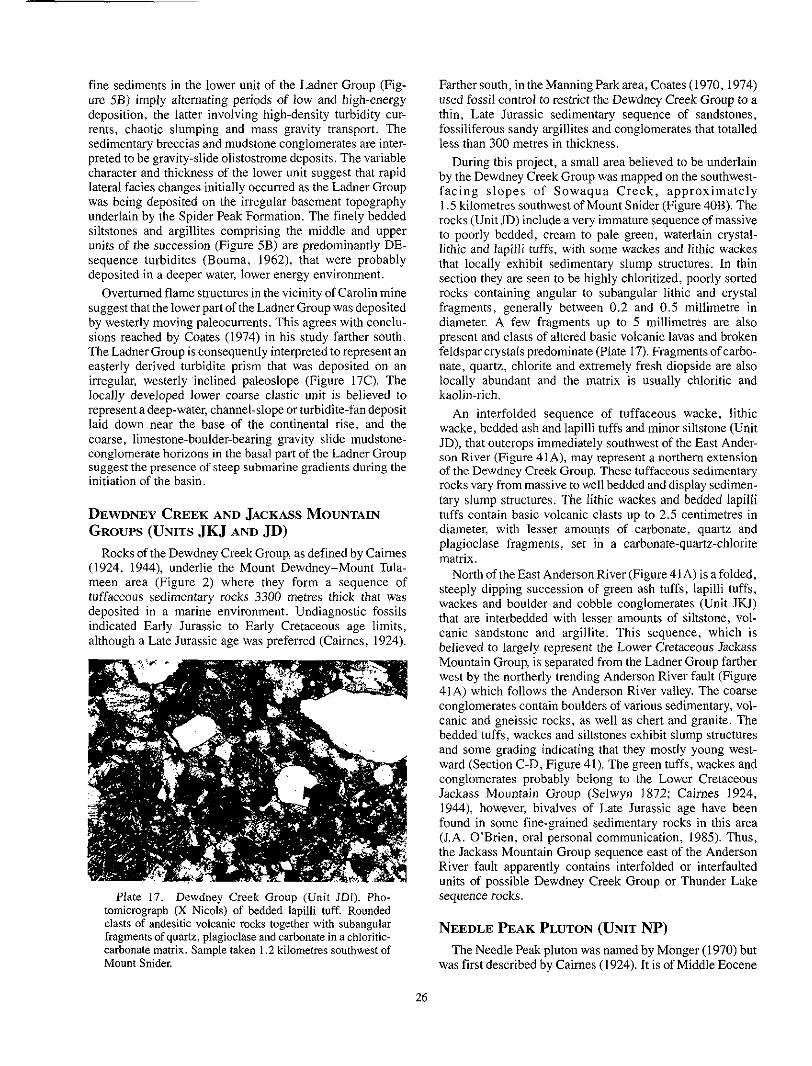
fine sediments in the lower unit of the Ladner Group (Fig-
deposition, the latter involving high-density turbidity cur- ure 5B) imply alternating periods of low and high-energy
rents, chaotic slumping and mass gravity transport. The sedimentary breccias and mudstone conglomerates are inter- preted to be gravity-slide olistostrome deposits. The variable character and thickness of the lower unit suggest that rapid lateral facies changes initially occurred as the Ladner Group was being deposited on the irregular basement topography underlain by the Spider Peak Formation. The finely bedded siltstones and argillites comprising the middle and upper
sequence turbidites (Bouma, 1962), that were probably units of the succession (Figure 5B) are predominantly DE-
deposited in a deeper water, lower energy environment.
suggest that the lower part of the Ladner Group was deposited Overturned flame structures in the vicinity of Carolin mine
by westerly moving paleocurrents. This agrees with conclu- sions reached by Coates (1974) in his study farther south. The Ladner Group is consequently interpreted to represent an easterly derived turbidite prism that was deposited on an irregular, westerly inclined paleoslope (Figure 17C). The locally developed lower coarse clastic unit is believed to represent a deep-water, channel-slope or turbidite-fan deposit laid down near the base of the continental rise, and the coarse, limestone-boulder-bearing gravity slide mudstone- conglomerate horizons in the basal part of the Ladner Group suggest the presence of steep submarine gradients during the initiation of the basin.
DEWDNEY CREEK AND JACKASS MOUNTAIN GROUPS (UNITS JKJ AND JD)
(1924, 1944), underlie the Mount Dewdney-Mount Tula- Rocks of the Dewdney Creek Group, as defined by Cairnes
meen area (Figure 2) where they form a sequence of
deposited in a marine environment. Undiagnostic fossils tuffaceous sedimentary rocks 3300 metres thick that was
indicated Early Jurassic to Early Cretaceous age limits, although a Late Jurassic age was preferred (Cairnes, 1924).
Farther south, in the Manning Park area, Coates (1970, 1974)
thin, Late Jurassic sedimentary sequence of sandstones, used fossil control to restrict the Dewdney Creek Group to a
fossiliferous Sandy argillites and conglomerates that totalled less than 300 metres in thickness.
During this project, a small area believed to be underlain by the Dewdney Creek Group was mapped on the southwest- fac ing s lopes of Sowaqua Creek , approximate ly
rocks (Unit JD) include a very immature sequence of massive 1.5 kilometres southwest of Mount Snider (Figure 40B). The
to poorly bedded, cream to pale green, waterlain crystal-
that locally exhibit sedimentary slump structures. In thin lithic and lapilli tuffs, with some wackes and lithic wackes
section they are seen to be highly chloritized, poorly sorted rocks containing angular to subangular lithic and crystal fragments, generally between 0.2 and 0.5 millimetre in diameter. A few fragments up to 5 millimetres are also
feldsparcrystalspredominate (Plate 17). Fragmentsofcarbo- present and clasts of altered basic volcanic lavas and broken
nate, quartz, chlorite and extremely fresh diopside are also
kaolin-rich. locally abundant and the matrix is usually chloritic and
wacke, bedded ash and lapilli tuffs and minor siltstone (Unit An interfolded sequence of tuffaceous wacke, lithic
JD), that outcrops immediately southwest of the East Ander- son River (Figure 41A), may represent a northern extension of the Dewdney Creek Group. These tuffaceous sedimentary rocks vary from massive to well bedded and display sedimen- tary slump structures. The lithic wackes and bedded lapilli tuffs contain basic volcanic clasts up to 2.5 centimetres in diameter, with lesser amounts of carbonate, quartz and plagioclase fragments, set in a carbonate-quartz-chlorite matrix.
North of the East Anderson River (Figure 41A) is a folded, steeply dipping succession of green ash tuffs, lapilli tuffs, wackes and boulder and cobble conglomerates (Unit JKJ) that are interbedded with lesser amounts of siltstone, vol- canic sandstone and argillite. This sequence, which is believed to largely represent the Lower Cretaceous Jackass Mountain Group, is separated from the Ladner Group farther west by the northerly trending Anderson River fault (Figure
conglomerates contain boulders of various sedimentary, vol- 41A) which follows the Anderson River valley. The coarse
canic and gneissic rocks, as well as chert and granite. The bedded tuffs, wackes and siltstones exhibit slump structures and some grading indicating that they mostly young west- ward (Section C-D, Figure 41). The green tuffs, wackes and
Jackass Mountain Group (Selwyn 1872; Cairnes 1924, conglomerates probably belong to the Lower Cretaceous
1944), however, bivalves of Late Jurassic age have been found in some fine-grained sedimentary rocks in this area
the Jackass Mountain Group sequence east of the Anderson (LA. O’Brien, oral personal communication, 1985). Thus,
River fault apparently contains interfolded or interfaulted units of possible Dewdney Creek Group or Thunder Lake
Plate 17. Dewdney Creek Group (Unit JDI). Pho- tomicrograph (X Nicols) of bedded lapilli tuff. Rounded
sequence rocks.
clasts of andesitic volcanic rocks together with subangular fragments of quartz, plagioclase and carbonate in a chloritic- carbonate matrix. Sample taken 1.2 kilometres southwest of Mount Snider. was first described by Caimes (1924). It is of Middle Eocene
The Needle Peak pluton was named by Monger (1970) but
NEEDLE PEAK PLUTON (UNIT N P )
26

age (Greig, 1989) and outcrops over an area of 200 square kilometres, intruding and crosscutting the sedimentary rocks of the Methow-Pasayten trough east of Carolin mine (Fig- ure 2). Much of its southeastern contact coincides with a fault along; the Coquihalla valley, while a portion of its north-
dextral transcurrent movement along the Anderson River western margin is possibly offset by I to 2 kilometres of
fault (Figure 2). Caimes (1924) describes the pluton as a massive, coarse-grained granite and granodiorite that con- tains biotite and hornblende.
Du.ring this study parts of the western margin of the main pluton were mapped (Figures 40A and 41B). This contact is characterized by swarms of various minor felsic and basic intrusives and a wide thermal metamorphic aureole that overprints the Ladner Group country rocks. The Needle Peak pluton comprises massive, grey to very pale pink, medium to Plate 18. Ladner Group argillite (Unit ILa) thermally coarse-grained rocks of granitic, quartz monzonitic and metamorphosed by the Needle Peak pluton. Photomicro- granodioritic composition. They include both equigranular graph (X Nicols) showing euhedral andalusite crystal (upper and porphyritic varieties that generally contain from 1 to 4 right) and anhedral cordierite crystal containing abundant per cent biotite, 15 to 25 per cent quartz, and variable inclusions (lower left). The groundmass includes biotite amounts of Dotassium feldsoar and andesine-oligoclase olae- (after chlorite), quartz and fine carbonaceous material. - . 1 ioclac:e. In thin section they are seen to be moderately fresh rocks with some biotite laths being weakly chloritized, while the feldspars are clouded and partially altered. Phenocrysts
plagioclase and potassium feldspar that are complexly zoned may exceed 1 centimetre in diameter and include both
Trace to accessory minerals include microcline, chlorite, and contain small randomly orientated flakes of muscovite.
muscovite, zircon, tremolite, sporadic hornblende and pyrite.
Southeast of Hidden Creek (Figure 41B) the pluton is locally strongly altered and contains quartz veins and small, open (cavities lined with euhedral quartz crystals. The altered granodiorite is characterized by a general absence of biotite, but contains variable amounts of muscovite, carbonate and disseminated pyrite. The muscovite forms fresh, coarse flakes and the carbonate occurs as both interstitial crystals in the groundmass and coarser aggregates up to 0.5 millimetre
some disseminated skeletal ilmenite is also present. in diameter. The pyrite forms scattered euhedral cubes, and
Tht: thermal metamorphic aureole that overprints the Ladne:r Group along the western margin of the pluton is generally 0.75 kilometre wide, but may exceed a width of
are distinguished by a siliceous, black appearance and the 1.4 kilometres. The hornfelsed slaty argillites and siltstones
presence of fine-grained biotite with variable amounts of
pluton are spotted with porphyroblasts of biotite, andalusite disseminated pyrite. Some hornfelsed outcrops closer to the
and cordierite (Plate 18).
In thin section the homfelses contain abundant very fine
for the black colour of these rocks. The groundmass largely carbonaceous and other opaque material which is responsible
comprises fine-grained biotite, quartz and plagioclase which have a. pronounced subparallel alignment and have grown along .the original S t slaty cleavage (Plate 18). Larger, dark red biotite porphyrohlasts up to 2 millimetres in length are also present mimetically overgrowing the original chloritic foliation. Locally the hornfelses are cut by thin quartz- feldspar veins containing fresh, coarse biotite crystals and
metamorphosed by the Needle Peak pluton. Photomicro- Plate 19. Ladner Group siltstone (Unit JLs) thermally
graph (PPL) of siltstone containing fine carbonaceous mate- rial and biotite cut by a vein containing quartz and coarse biotite.
sporadic sericite; the biotite in the veins, in contrast to the porphyroblasts overgrowing the hornfelsic groundmass, does not generally contain opaque inclusions (Plate 19).
The spotted hornfelsic slates generally contain numerous euhedral to subhedral rectangular crystals of chiastolitic andalusite up to 0.4 millimetre in diameter which have overgrown the biotite foliation without disturbance (Plate IS). Less commonly, the spotted slates also contain rounded, diffuse, anhedral cordierite porphyrohlasts up to 5 millimetres wide. These crystals are generally packed with opaque inclusions and occasionally exhibit lamellar and sector twinning, as well as some yellow-coloured pinite alteration. Accessory minerals in the hornfelsed metasedi- mentary rocks include pyrite, pyrrhotite, sericite and chlorite.
21
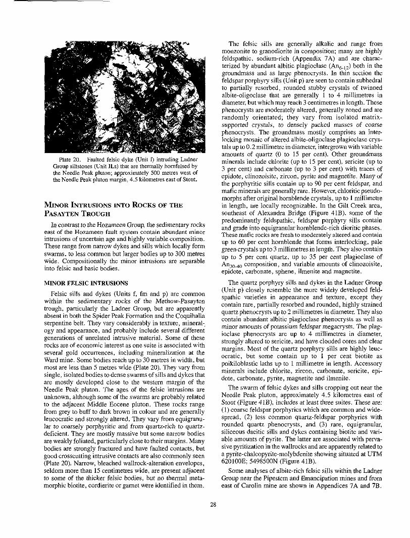
Plate 20. Faulted felsic dyke (Unit 9 intruding Ladner Group siltstones (Unit JLs) that are thermally homfelsed by
the Needle Peak pluton margin, 4.5 kilometres east of Stout. the Needle Peak pluton; approximately 500 metres west of
MINOR INTRUSIONS INTO ROCKS OF THE PASAYTEN TROUGH
east of the Hozameen fault system contain abundant minor In contrast to the Hozameen Group, the sedimentary rocks
intrusions of uncertain age and highly variable composition. These range from narrow dykes and sills which locally form swarms, to less common but larger bodies up to 300 metres wide. Compositionally the minor intrusions are separable into felsic and basic bodies.
MINOR FELSIC INTRUSIONS
Felsic sills and dykes (Units f, fm and p) are common
trough, particularly the Ladner Group, but are apparently within the sedimentary rocks of the Methow-Pasayten
absent in both the Spider Peak Formation and the Coquihalla serpentine belt. They vary considerably in texture, mineral-. ogy and appearance, and probably include several different generations of unrelated intrusive material. Some of these rocks are of economic interest as one suite is associated with several gold occurrences, including mineralization at the Ward mine. Some bodies reach up to 30 metres in width, but most are less than 5 metres wide (Plate 20). They vary from single, isolated bodies to dense swarms of sills and dykes that are mostly developed close to the western margin of the Needle Peak pluton. The ages of the felsic intrusions are unknown, although some of the swarms are probably related to the adjacent Middle Eocene pluton. These rocks range from grey to buff to dark brown in colour and are generally leucocratic and strongly altered. They vary from equigranu- lar to coarsely porphyritic and from quartz-rich to quartz- deficient. They are mostly massive hut some narrow bodies are weakly foliated, particularly close to their margins. Many bodies are strongly fractured and have faulted contacts, but good crosscutting intrusive contacts are also commonly seen (Plate 20). Narrow, bleached wallrock-alteration envelopes, seldom more than 15 centimetres wide, are present adjacent to some of the thicker felsic bodies, but no thermal meta- morphic biotite, cordierite or garnet were identified in them.
monzonite to granodiorite in composition; many are highly The felsic sills are generally alkalic and range from
feldspathic, sodium-rich (Appendix 7A) and are charac-
groundmass and as large phenocrysts. In thin section the terized by abundant albitic plagioclase (An,,,) both in the
feldspar porphyry sills (Unit p) are seen to contain subhedral to partially resorbed, rounded stuhhy crystals of twinned
diameter, but which may reach 3 centimetres in length. These albite-oligoclase that are generally I to 4 millimetres in
phenocrysts are moderately altered, generally zoned and are randomly orientated; they vary from isolated matrix-
phenocrysts. The groundmass mostly comprises an inter- supported crystals, to densely packed masses of coarse
locking mosaic of altered albite-oligoclase plagioclase crys- tals up to 0.2 millimetre in diameter, intergrown with variable amounts of quartz (0 to 15 per cent). Other groundmass minerals include chlorite (up to 15 per cent), sericite (up to
epidote, clinozoisite, zircon, pyrite and magnetite. Many of 3 per cent) and carbonate (up to 3 per cent) with traces of
the porphyritic sills contain up to 90 per cent feldspar, and mafic minerals are generally rare. However, chloritic pseudo-
in length, are locally recognizable. In the Gilt Creek area, morphs after original hornblende crystals, up to I millimetre
predominantly feldspathic, feldspar porphyry sills contain southeast of Alexandra Bridge (Figure 41B), some of the
These mafic rocks are fresh to moderately altered and contain and grade into equigranular hornblende-rich dioritic phases.
green crystals up to 3 millimetres in length. They also contain up to 60 per cent hornblende that forms interlocking, pale
up to 5 per cent quartz, up to 35 per cent plagioclase of An,,., composition, and variable amounts of clinozoisite, epidote, carbonate, sphene, ilmenite and magnetite.
(Unit p) closely resemble the more widely developed feld- The quartz porphyry sills and dykes in the Ladner Group
contain rare, partially resorbed and rounded, highly strained spathic varieties in appearance and texture, except they
quartz phenocrysts up to 2 millimetres in diameter. They also contain abundant albitic plagioclase phenocrysts as well as minor amounts of potassium feldspar megacrysts. The plag- ioclase phenocrysts are up to 4 millimetres in diameter, strongly altered to sericite, and have clouded cores and clear
ocratic, but some contain up to 1 per cent biotite as margins. Most of the quartz porphyry sills are highly leuc-
poikiloblastic laths up to 1 millimetre in length. Accessory minerals include chlorite, zircon, carbonate, sericite, epi- dote, carbonate, pyrite, magnetite and ilmenite.
Needle Peak pluton, approximately 4.5 kilometres east of The swarm of felsic dykes and sills cropping out near the
Stout (Figure 41B), includes at least three suites. These are: ( I ) coarse feldspar porphyries which are common and wide- spread, (2) less common quartz-feldspar porphyries with rounded quartz phenocrysts, and (3) rare, equigranular, siliceous dacitic sills and dykes containing biotite and vari- able amounts of pyrite. The latter are associated with perva- sive pyritization in the wallrocks and are apparently related to a pyrite-chalcopyrite-molybdenite showing situated at UTM 620100E 5498500N (Figure 41B).
Some analyses of albite-rich felsic sills within the Ladner Group near the Pipestem and Emancipation mines and from east of Carolin mine are shown in Appendices 7A and 7B.
28
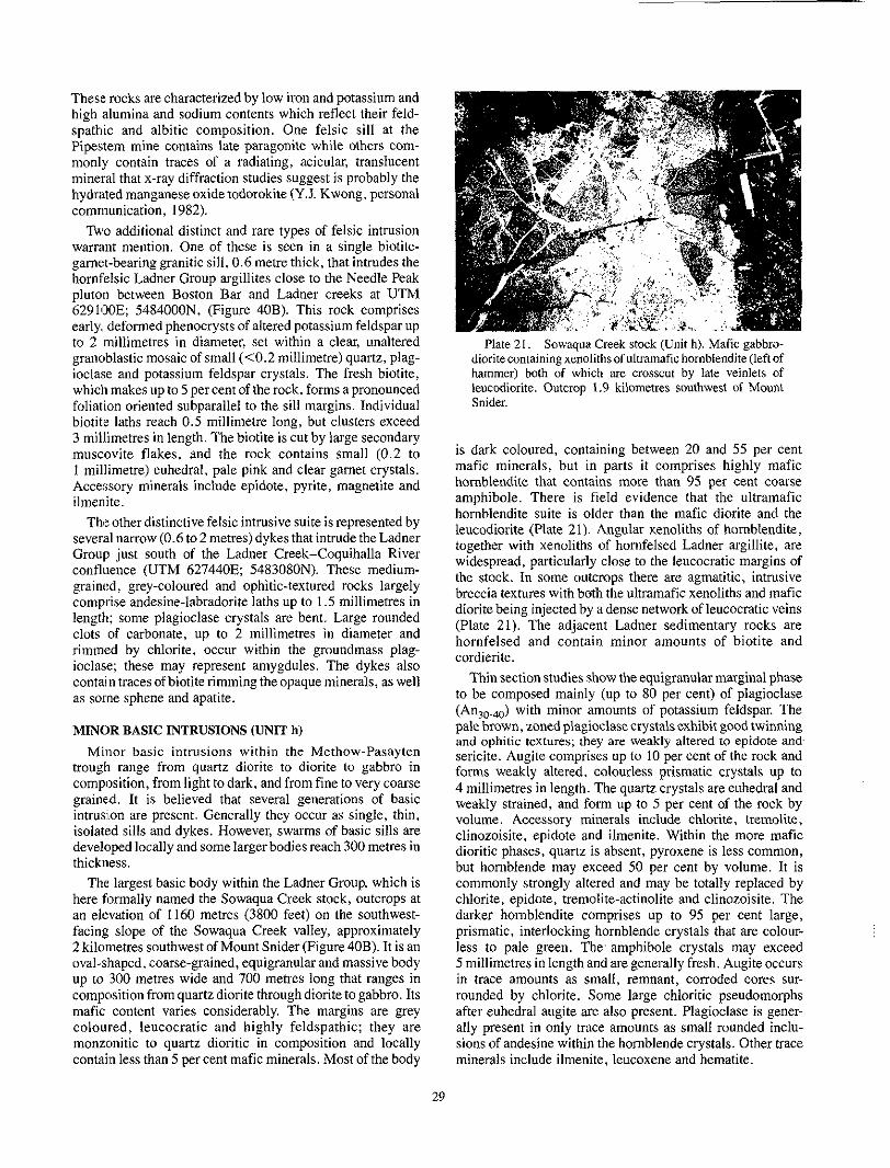
These rocks are characterized by low iron and potassium and high alumina and sodium contents which reflect their feld- spathic and albitic composition. One felsic sill at the Pipestem mine contains late paragonite while others com- monly contain traces of a radiating, acicular, translucent mineral that x-ray diffraction studies suggest is probably the hydrated manganese oxidetodorokite (Y.J. Kwong, personal communication, 1982).
warrant mention. One of these is seen in a single biotite- Two additional distinct and rare types of felsic intrusion
garnet-bearing granitic sill, 0.6 metre thick, that intrudes the hornfelsic Ladner Group argillites close to the Needle Peak pluton between Boston Bar and Ladner creeks at UTM 629113OE; 5484000N, (Figure 40B). This rock comprises early, deformed phenocrysts of altered potassium feldspar up to 2 millimetres in diameter, set within a clear, unaltered granoblastic mosaic of small (<0.2 millimetre) quartz, plag- ioclase and potassium feldspar crystals. The fresh biotite, which makes up to 5 per cent of the rock, forms apronounced foliation oriented subparallel to the sill margins. Individual biotit'e laths reach 0.5 millimetre long, but clusters exceed 3 millimetres in length. The biotite is cut by large secondary muscovite flakes, and the rock contains small (0.2 to 1 millimetre) euhedral, pale pink and clear gamet crystals. Accessory minerals include epidote, pyrite, magnetite and ilmenite.
The other distinctive felsic intrusive suite is represented by
Group just south of the Ladner Creek-Coquihalla River several narrow (0.6 to 2 metres) dykes that intrude the Ladner
confluence (UTM 627440E; 5483080N). These medium- grained, grey-coloured and ophitic-textured rocks largely comprise andesine-labradorite laths up to 1.5 millimetres in length; some plagioclase crystals are bent. Large rounded
rimmed by chlorite, occur within the groundmass plag- clots of carbonate, up to 2 millimetres in diameter and
ioclase; these may represent amygdules. The dykes also contain traces ofbiotite rimming the opaque minerals, as well as some sphene and apatite.
MINOR BASIC INTRUSIONS (UNIT h)
Minor basic intrusions within the Methow-Pasayten trough range from quartz diorite to diorite to gabbro in composition, from light to dark, and from fine to very coarse g1aine.d. It is believed that several generations of basic intrusion are present. Generally they occur as single, thin, isolated sills and dykes. However, swarms of basic sills are developed locally and some larger bodies reach 300 metres in thickness.
The largest basic body within the Ladner Group, which is here formally named the Sowaqua Creek stock, outcrops at an elevation of 1160 metres (3800 feet) on the southwest- facing slope of the Sowaqua Creek valley, approximately
oval-shaped, coarse-grained, equigranular and massive body 2 kilometres southwest of Mount Snider (Figure 40B). It is an
up to 300 metres wide and 700 metres long that ranges in composition from quartz diorite through diorite to gabbro. Its mafic content varies considerably. The margins are grey coloured, leucocratic and highly feldspathic: they are monzonitic to quartz dioritic in composition and locally contain less than 5 per cent mafic minerals. Most of the body
dioritecontaining xenolithsofullramafic hornblendite(lef1 of Plate 21. Sowaqua Creek stock (Unit h). Mafic gabbro-
hammer) both of which are crosscut by late veinlets of leucodiorite. Outcrop I .9 kilometres southwest of Mount Snider.
is dark coloured, containing between 20 and 55 per cent mafic minerals, hut in parts i t comprises highly mafic hornblendite that contains more than 95 per cent coarse amphibole. There is field evidence that the ultramafic hornblendite suite is older than the mafic diorite and the leucodiorite (Plate 21). Angular xenoliths of homblendite, together with xenoliths of hornfelsed Ladner argillite, are widespread, particularly close to the leucocratic margins of the stock. In some outnops there are agmatitic, intrusive breccia textures with both the ultramafic xenoliths and mafic diorite being injected by a dense network of leucocratic veins (Plate 21). The adjacent Ladner sedimentary rocks are hornfelsed and contain minor amounts of biotite and cordierite.
to be composed mainly (up to 80 per cent) of plagioclase Thin section studies show the equigranular marginal phase
(An,,,) with minor amounts of potassium feldspar. The pale brown, zoned plagioclase crystals exhibit good twinning and ophitic textures; they are weakly altered to epidote and-
forms weakly altered. colourless prismatic crystals up to sericite. Augite comprises up to I O per cent of the rock and
4 millimetres in length. The quartz crystals are euhedral and weakly strained, and form up to 5 per cent of the rock by volume. Accessory minerals include chlorite, tremolite, clinozoisite, epidote and ilmenite. Within the more mafic dioritic phases, quartz is absent, pyroxene is less common, but hornblende may exceed 50 per cent by volume. It is commonly strongly altered and may he totally replaced by chlorite, epidote, tremolite-actinolite and clinozoisite. The darker homblendite comprises up to 95 per cent large, prismatic, interlocking hornblende crystals that are colour- less to pale green. The' amphibole crystals may exceed 5 millimetres in length and are generally fresh. Augite occurs
rounded by chlorite. Some large chloritic pseudomorphs in trace amounts as small, remnant, corroded cores sur-
after euhedral augite are also present. Plagioclase is gener- ally present in only trace amounts as small rounded inclu- sions of andesine within the hornblende crystals. Other trace minerals include ilmenite, leucoxene and hematite.
29

Several dioritic sills and dykes, one of which is 70 metres wide and nearly 1 kilometre in length, outcrop between 0.5
These minor intrusions are believed to be coeval and related and 1.5 kilometres southwest of the Sowaqua Creek stock.
to the larger body. Some of them have faulted contacts, and
contain quartz and carbonate veining and minor pyrite. The are enveloped by narrow thermal metamorphic aureoles that
diorites are strongly altered; most of the original pyroxene and hornblende is replaced by actinolite and chlorite, although some small remnant cores of augite are preserved. The andesitic plagioclase, which forms up to 60 per cent of these rocks, is clouded, zoned and weakly altered, and contains small needle-like crystals of tremolite-actinolite. Occasional phenocrysts of altered plagioclase up to 5 milli- metres in length are present.
Farther north, east of Ladner Creek, and within or close to the thermal aureole of the Needle Peak pluton, is a northerly trending swarm of mafic sills and dykes of dioritic and gabbroic composition. They are mostly less than 20 metres thick and are probably coeval and related to the Sowaqua Creek stock. However, one oval-shaped basic intrusion out- cropping just north of the Coquihalla River (UTM 628850E; 5483700N) is 150 metres wide. This body is similar to the larger SowaqudCreek stock. It includes a central core of
diorite and quartz diorite; toward the margins, the body coarse-grained hornblendite which grades outwards to
becomes more leucocratic and feldspathic and the fine- grained chilled margins are siliceous and of granodioritic composition. The intrusion sharply crosscuts bedding in the Ladner Group and the contacts are steeply dipping. The body is weakly cleaved in places; this cleavage is subparallel to the slaty cleavage in the surrounding Ladner Group, which
regional D, episode of deformation (see Table 3). The adja- suggests this suite of mafic intrusions was affected by the
cent argillites are black, hornfelsed and spotted; they contain
honaceous material, as well as both well-aligned and ran- an abundance of exceedingly fine grained disseminated car-
domly orientated red-brown biotite laths up to 0.5 millimetre in length, and some euhedral, inclusion-filled cordierite crystals.
comprise over 90 per cent hornblende forming interlocking, In thin section the hornblendite core of this body is seen to
mostly fresh, pale green to pale brown crystals up to 1.5 centimetres in length. There is minor alteration to sericite
and chlorite, and the rock contains traces of plagioclase, carbonate, epidote, sphene and pyrite. The dioritic phases are also coarse grained butaltered. They contain up to 25 percent hornblende, forming crystals exceeding 1 centimetre in length, that are rimmed by chlorite. The amphibole crystals
of randomly orientated biotite. The altered, twinned plag- contain abundant small opaque inclusions, as well as flakes
ioclase crystals form up to 75 per cent of the rock; they also contain radiating needles of tremolite and minute biotite
tite and ilmenite. The biotite alteration in the amphibole flakes. Other trace minerals include apatite, zircon, magne-
crystals may be due to thermal overprinting by the nearby Needle Peak pluton. The quartz diorite phases of the body contain between 5 and 8 per cent quartz, but the fine-grained chilled margins contain up to 50 per cent quartz. This forms a granoblastic mosaic of minute crystals less than 0.2 milli- metre in size, intergrown with clouded, altered plagioclase. This contact phase also contains clusters of muscovite up to
euhedral pink garnet crystals. I millimetre in diameter, traces of biotite, and small, clear,
between Ladner Creek and the Needle Peak pluton contain The swarms of basic sills and dykes of this suite exposed
between 35 and 45 per cent hornblende and 40 to 65 per cent fresh andesine-labradorite plagioclase, as well as accessory chlorite, apatite, carbonate, sphene, ilmenite and magnetite. These sills and dykes, like the larger differentiated body north of the Coquihdlla River, have narrow thermal meta- morphic aureoles containing biotite and cordierite.
unrelated to the previously described suite, are found Other minor gabbroic and andesitic intrusives, apparently
throughout the Ladner Group. For example, a single east- northeasterly trending dyke of porphyritic diorite (Unit h), 2 metres wide, crops out 3 kilometres northeast of Serpentine Lake (UTM 5479600E; 629500E) at an elevation of
zoned phenocrysts of plagioclase up to 2 centimetres in 1065 metres (3500 feet). It contains euhedral, clouded and
length, set in a groundmass of andesitic plagioclase (60 to 75 per cent) and chloritized hornblende (up to 20 per cent). Accessory minerals include tremolite-actinolite, quartz and sulphides. Several minor dioritic and gabbroic bodies cut the Ladner Group north of Siwash Creek, and possible Dewdney Creek wackes and tuffs (Unit JD) southwest of the East Anderson River. These rocks contain up to 70 per cent pale brown hornblende as stubby, weakly chloritized crystals, and 25 to 50 per cent altered andesine-labradorite plagioclase.
30

STRUCTURAL GEOLOGY
GEOLOGICAL HISTORY OF THE HOPE- Group and Bridge River complex and thus represent a BOSTON BAR AREA fundamental feature of the basin volcanism.
occurred west and east of the Hozameen fault is outlined A history of the geological events believed to have
respectively in Tables 2 and 3. The Hozameen. Petch Creek and Pasayten faults separate
four (contrasting crustal units whose relationships to one anoth'zr are still poorly understood: from west to east these units ;are the Custer-Skagit gneiss, the Hozameen Group, the Methow-Pasayten trough and the Mount Lytton-Eagle plu- tonic complex. The sedimentary rocks in the trough are
from Early Jurassic to Middle Eocene. The oldest sedimen- mainly turbidite and successor basin deposits ranging in age
tary sequence, the Ladner Group, has been interpreted to reprer.ent either fore-arc sediments (Anderson, 1976) or a turbidite prism laid down along the margin of an oceanic or backmc basin (Ray, 1986b); they were unconformably deposited on a westerly inclined paleoslope underlain by the Spider Peak Formation. The Spider Peak Formation, on the basis (of tenuous microfossil evidence, may be Early Triassic in age; i t is characterized by sodic, ocean-floor subalkaline basalts that probably formed i n a spreading-ridge environment.
The Hozameen Group includes basaltic greenstones, ultra- mafic rocks and thick sequences of chert, and is interpreted to be an ophiolite suite. Its volcanic rocks include both island arc tholeiites and ocean island-seamount assemblages, but
suggested that many ophiolites formed within marginal back- mid-oceanicridge basalts(M0RB) are absent. Dewey (1974)
the island of Cyprus, show evidence of crustal extension such arc ba:sins; some, such as the classical Troodos ophiolites on
as she8:ted dyke complexes (Gass, 1967; Moores and Vine, 1971), but possess island arc geochemical characteristics (Miyajhiro, 1973; Schmincke er al. , 1983). Robinson et al. (1983:' concluded that the island arc at Troodos was immature
environment is inferred for the Hozameen Group arc volca- and formed over relatively thin oceanic crust. A similar
nism; .the scarcity of pyroclastics may reflect both its imma- turity and its initial development in deep water, although there are indications that the upper parts of the succession were deposited in a more shallow marine environment.
The Hozameen Group in the Maselpanik area of south- westem British Columbia (Figure 2) and Jack Mountain area
Jurassic (Haugerud, 1985). Thus, the upper portion of the of Washington State ranges in age from Permian to Middle
Hozameen Group is time equivalent to the lower pan of the Ladner Group. Haugerud (1985) recognized two basaltic eruptive episodes in the Hozameen Group which produced a Permian tholeiitic suite and an Upper Triassic ocean island- seamount suite. These may be stratigraphically equivalent to the two volcanic suites recognized in the Hope-Boston Bar
tenuous. The geochemical evidence (Potter, 1983; area, although the lack of fossil control makes this correlation
Haugerud, 1985; this study) suggests that these two volcanic suites are regionally developed throughout the Hozameen
meen Group and Methow-Pasayten trough are still controver- Due to sparse data, the relationships between the Hoza-
sial and two divergent views have been suggested. O'Brien
tures for the Hozameen Group and Spider Peak Formation (1987) argued that contrasting volcanic geochemical signa-
indicate they were not closely associated prior to Jurassic time. Alternatively Ray (1986b) considered the rocks on either side of the Hozameen fault to be related, rather than independently developed elements juxtaposed by later plate movement; i t was argued that the rocks of the Hozameen Group, Spider Peak Formation and Methow-Pasayten trough were deposited in a single, long-lived oceanic or marginal basin.
The early history of this basin involved development of a Permo-Triassic subduction-related volcanic arc and eruption oftheHozameen Group arc tholeiites (Figure 17A). Continu- ing subduction was accompanied farther east by back-arc
rifting in this basin resulted in Early Triassic volcanism spreading and development of a marginal basin; sea-floor
Throughout the Triassic, deposition was mainly charac- responsible for the Spider Peak Formation (Figure 17A).
terized by deep-water cherts; however, the presence of both arc tholeiite and ocean island-seamount volcanic rocks in the Hozameen Group suggests that they may have been deposited in a multi-rifted back-arc basin. Proposed models for such complexly rifted marginal basins indicate that they involve oblique spreading and subduction movements and form
Tamaki, 1985). The apparent absence of a mature volcanic above shallow-dipping subduction zones (Dewey, 1980;
arc in the Hozameen Group may reflect its removal from the region either by oblique sea-floor spreading or later transcur- rent faulting (Figure 17B).
apparently migrated eastward (Figure 17B) and the easterly During Middle to Late Triassic time the subduction zone
subduction of oceanic lithosphere then took place beneath rocks of the Mount Lytton-Eagle plutonic complex to pro- duce the Nicola arc (Monger et al. , 1972; Godwin, 1975; Monger, 1975, 1977; Anderson, 1976; Preto, 1979). However, the relationship between the plutonic complex to the east and rocks of the Methow-Pasayten trough and Hozameen Group to the west is uncertain (Figures 17B and 17C) because the timing and amount of transcurrent move-
erly derivation, the lack of tuffaceous material in most of the ment along the Pasayten fault is unknown. Despite its east-
Ladner Group (apart from the lowermost units), and the preponderance of argillites laid down in a low-energy environment, argue against deposition in an active fore-arc basin. There are indications, however, that the Late Jurassic Thunder Lake sequence of O'Brien (1987) and the Cre- taceous and younger sediments in the trough were deposited in a fore-arc environment. No convincing evidence exists that the eroded rocks of the Mount Lyttoo-Eagle plutonic complex contributed to the Methow-Pasayten trough until Cretaceous time, and the sedimentation in both the Ladner
31

HISTORY OF EVENTS WEST OF THE HOZAMEEN FAULT TABLE 2.
(Oligocene to Early 16-35 Ma
Miocene)
(Late Eocene) 40-44 Ma
?
Post Mid- Cretaceous
Post Mid- Cretaceous
Permian to Jurassic
Event
Late faulting - A southeast to south-southeast-trending set followed by a northeast to north-northeast-striking set.
Intrusion of the Chilliwack batholith.
Major dextral transcurrent displacement along the Petch Creek and Hozameen faults; this was possibly related to the right-lateral movements along the Fraser fault system.
Intrustion of the Hells Gate pluton into the Custer-Skagit gneiss (Wanless, et al., 1973).
Local kink folding and development of a strain-slip cleavage.
D, - open. upright folding with southeast-striking axial planes and subhorizontal axes.
associated with the development of the regional S , slaty cleavage. Possibly related to the easterly overriding of the D, - asymmetric, open to tight, similar folding with southeast-trending axial planes and subhorizontal axes,
Hozameen Group onto the Pasayten trough rocks along a precursor Stmcture to the Hozameen fault.
Hozameen Group volcanism and sedimentation, possibly in a multirifted marginal back-arc basin environment.
HISTORY OF EVENTS EAST OF THE HOZAMEEN FAULT TABLE 3.
Age Event
Late faulting - A southeasterly trending set followed by a northeast to east-northeasterly striking Set
21 Ma Deposition and emplacement of the Coquihalla volcanic complex. (Early Miocene)
Chuwanten fault: possibiy related to right-lateral movement along the Fraser fault system. Regional dextral strike-slip movement along the Hozameen fault and minor transcurrent displacement along the
(Late Eocene) 46 Ma Intrusion of the Needle Peak pluton and related felsic dyke swarm into the Pasayten trough rocks
? Local kink folding and development of a strain-slip cleavage with axial planes striking east-sautheast and south
Post Mid- Cretaceous
Post Mid- cretaceous
D, - major concentric to similar-type, open to tight, upright to asymmetric folding in the Ladner Group with
occurred with extensive late D, flattening and formation of the L, lineation. southeasterly striking axial planes and subhorizontal axes; development of the regional S, axial planer slaty cleavage
D, - asymmetric folding in the Ladner Creek area, but no associated metamorphic axial planer fabric was developed.
Post Mid- D, - oblique, easterly directed thrusting along the precursors to the Hozameen and Chuwanten faults, causing local Cretaceous Smctural inversion of the Ladner Group and Spider Peak Formation.
Early Cretaceous to Middle Eocene
Closure of the Pasayten trough.
Group and the upper parts of the Hozameen Group was probably unrelated to, and unaffected by, subduction that occurred farther east toward the Nicola arc (Figure 17C). The Ladner Group was apparently deposited along the eastern margin of an extensive oceanic or back-arc basin; it may
Early to Middle Jurassic oceanic sequence (Haugerud, 1985) represent a proximal facies equivalent to the more distal,
in the upper part of the Hozameen Group (Figure 17C). During Late Jurassic time, the basin began to close, and by
Early Cretaceous time a western margin to the Methow- Pasayten trough had developed (Figure 17D); this was marked by sedimentation from both western and eastern sources (Coates, 1974; Kleinspehn, 1985; Trexler and Bour- geois, 1985). Davis er al. (1978) and Trexler and Bourgeois (1985) believed that the trough was generated by dextral wrench faulting during mid-Cretaceous time and that the basin had an active, high-relief western margin with exten- sive westerly derived fan deltas, and a low, stable eastern
3L

margin. However, recent workers (Mohrig and Bourgeois, 1986; McGroder, 1988) argue that the basin was deforming during mid-Cretaceous overthrusting and believe there is little supportive evidence for syndepositional strike-slip activity. McGroder and Miller (1989) present two alternative models for the Oxfordian to Ceuomaniau evolution of the Methow-Pasayten trough in northern Washington. Their “pig@:yback model” involved the trough forming and resid- ing in a structurally high position during early and middle Albian time, while in the “foreland model” there was easterly overthrusting of the Hozameen Group, and the trough resided in a structurally low, foreland position. Struc- tural and stratigraphic data from this study support the
Group along a low-angle, westerly inclined thrust that was a foreland model with easterly overthrusting of the Hozameen
precu~:sor to the Hozameen fault (Figure 17D). Steady nar- rowing of the trough, accompanied by uplift of the Hoza-
during the Early to mid-Cretaceous led to sedimentation from meen Group and Mount Lytton-Eagle plutonic complex
Mountain and Pasayten groups (Figure 17D); episodic sedi- westem and eastern sources, and deposition of the Jackass
mentation in the trough continued into the Middle Eocene (Greig, 1989).
During the final closure of the trough, easterly directed movements continued, causing further easterly directed movement along the Hozameen fault and development of the Chuwanten fault (Figure 17E). These faults are now subverti- cal but structural inversion of the Spider Peak Formation and Ladner Group in the Carolin mine area suggests that the
thrust zone that originally dipped west (Figure 17D and E). Hozarneen fault represents an upturned, easterly directed
The same original orientation is surmised for the Chuwanten fault. The original inclination of the Pasayten fault is
ward (IGreig, 1989). The thrust movement along the Hoza- unknown although mid-Cretaceous fabrics dip steeply east-
meen fault was responsible for the emplacement and develop- ment (of the Coquihalla serpentine belt. The belt marks a major crustal boundary, a feature that is noted in many other ultramafic belts throughout the world (Shackleton, 1976). Many of these belts represent oceanic crust or upper mantle material emplaced as allochthonous slices during horizontal plate movement (Moores, 1970: Coleman, 1971). This mechanism is believed responsible for thrusting of incompe- tent oceanic ultramafic basement material along the Hoza- meen fault to produce the Coquihalla serpentine belt (Figure 17E); the belt represents ultramafic cumulate material derived from oceanic basement beneath the Spider Peak Formation. The spatial association between the Spider Peak Formation and Coquihalla serpentine belt along the Hoza- meen lfault, together with the geochemical similarity of the Coquihalla belt gabbros and Spider Peak greenstones (Fig-
being genetically and stratigraphically related. Conse- ures 91: and 9D), is supportive evidence for the two units
quently, the Spider Peak Formation and the Coquihalla serpentine belt are considered to represent oceanic layers 2 and 3 respectively (Cann, 1974): this suggests that the east- directed thrusting took place mainly along the West Hoza- meen lault, and that the East Hozameen fault is a relatively minor structure.
Following emplacement of the Coquihalla serpentine belt, and local structural inversion of the Ladner Group and Spider
Peak Formation, further compression was accommodated by
Methow-Pasayten trough, which were overprinted by a several periods of tight to open folding in rocks of the
regional slaty cleavage. The histories of the structural defor- mation west and east of the Hozameen fault are outlined in Tables 2 and 3. This later deformation reoriented the Hoza- meen fault and Coquihalla serpentine belt into their present subvertical position (Figures 17F, G and H).
Hozameen Group is uncertain, as are the ages and timing of The relationship between the Custer-Skagit gneiss and the
movements along the Petch Creek fault. The latter is a major, easterly inclined normal fault that is downthrown to the east. However, the lineations and structural styles identified in the fault suggest it has undergone both ductile and brittle defor- mations involving early transcurrent and later vertical move-
fault, like the Hozameen fault, developed as a westerly ments. Ray (1986b) originally suggested that the Petch Creek
gneiss was moved eastwards over the Hozameen group. inclined, Cretaceous thrust above which the Custer-Skagit
Subsequent studies on the Ross Lake fault farther south (Tabor ef al., 1989: Miller ef al., 1989; Haugerud, personal communcation, 1989) indicate that this hypothesis is unlikely. Instead, the recognition of Middle Eocene ductile extensional deformation in the Custer-Skagit gneiss (Haugerud etal. , in preparation) may have coincided with the vertical juxtaposing of deeper level gneisses against Hoza- meen Group. This suggests that late, normal movement along the Petch Creek fault was related to Tertiary crustal exten- sion. These extensional movements resulted in the emplace- ment of the Petch Creek serpentine belt which represents a basal part of the Hozameen Group succession (Figure 17G).
related swarm of felsic sills and dykes were intruded into During the Eocene, the Needle Peak pluton and its possibly
rocks of the Methow-Pasayten trough (Figure 17G). This was preceded and followed by large-scale dextral transcurrent displacement along the Petch Creek and Hozameen faults, similar to that described for other strike-slip faults in the Canadian Cordillera (Roddick, 1964; Tipper, 1969; Monger,
the regional offset of the felsic dyke swarms (Units p and fl 1977; Tempelman-Kluit, 1977). This movement resulted in
which are common in the Ladner Group, but absent west of the Hozameen fault. If these dykes are related to the 46 Ma Needle Peak pluton, it suggests that the strike-slip offset of the swarm was a post Middle Eocene event. This seemingly contradicts evidence from Washington State where the Hoza- meen fault is apparently cut and intruded by the 50 Ma Golden Horn batholith (McGroder, 1987). Some transcurrent movement along the Hozameen fault may have been related to dextral motion along the Fraser faults; Vance (1985)
Lake fault and younger Fraser faults took place during the suggested that the principal movements along the older Ross
Early to Middle Eocene. The major transcurrent faulting in the lower Fraser Canyon ended prior to the intrusion of the 16
and White, 1970: Richards and McTaggart, 1976; Vance, to 35 Ma Chilliwack and Mount Barr batholiths (Richards
1985), which cut across southern extensions of the Fraser and Petch Creek-Ross Lake faults (Figure 2). Consequently, intrusion of the Needle Peak pluton and Chilliwack batholith set maximum and minimum ages for regional transcurrent faulting in the Hope-Boston Bar area.
33

FAULTING IN THE DISTRICT The sequence of faulting in the Coquihalla district is not
clearly understood because of the complex, long-lived his- tory of fracturing and lack of age constraints. The two most important fractures, the Petch Creek and Hozameen faults, mark major crustal boundaries, are associated with ultra-
rent movements. The northerly trending Petch Creek fault is mafic belts, and have undergone both vertical and transcur-
believed to he a northern extension of the Ross Lake fault; i t dips steeply to moderately east, and the locally developed
Figure 18. Areas adjacent to the Hozameen fault that were subjected to structural analysis (see Figures 19 and 20).
subhorizontal mylonitic and rodding fabrics indicate it under- went ductile, possibly dextral transcurrent movement. Over- all it represents a normal fault that was downthrown to the east (Figure l7G). The Hozameen fault is mostly a steep east- dipping structure. It underwent an early, easterly directed episode of oblique thrust displacement that resulted in the upthrown Hozameen Group being moved eastwards over the
ures 17D and E). This overthrusting caused local tectonic less deformed and less metamorphosed Ladner Group (Fig-
and thrust thin, fault-bounded slices of the formation into the inversion of the Spider Peak Formation and Ladner Group,
Ladner Group succession; two thrust slices of Spider Peak Formation within the Ladner Group are seen at Carolin mine (Figure 42).
Coquihalla serpentine belt, it is separable into two fractures Where the Hozameen fault is spatially associated with the
that bound the belt, the East and West Hozameen faults. The East Hozameen fault is a brittle, normal structure that gener- ally separates the serpentine belt from either the Spider Peak Formation or the Ladner Group. Since the serpentinite and Spider Peak Formation are believed to be stratigraphically related, it suggests that the East Hozameen fault has under- gone relatively minor displacement (Figure 17H). By con- trast, the West Hozameen fault is believed to have been the main locus of both early overthrusting of the Hozameen Group, and later transcurrent, dextral displacement. Intense, subhorizontal linear structures are more prevalent in the
meen Fault, and the main transcurent movement is believed Hozameen Group immediately adjacent to the West Hoza-
to have been a post Needle Peak pluton (46 Ma) event.
River valley and trends subparallel to the Hozameen fault The Anderson River fault, which follows the Anderson
system, is not exposed. It is believed to be a steeply dipping
younger sediments of the Jackass Mounain Group from structure that was downthrown to the east, and it separates
Ladner Group rocks farther west. There is an increased development of a phyllitic foliation in argillites close to the fault, which are locally deformed by kink or strain-slip fold structures.
The Petch Creek, Hozameen and Anderson River faults are crosscut and displaced by a set of north-northeast to northeast-striking fractures. Movement along these younger faults is typically right lateral; this is best seen north of Spuzzum, where the Hozameen fault is displaced 7 to 8 kilometres. To the north these younger faults appear to merge
41B). Another group of northeast to north-northeast-striking into the north-striking Anderson River fault (Figure 41A and
faults is seen southeast of Serpentine Lake (Figure 40B),
fault with right-lateral offset. They represent a southwestern where they cut the Coquihalla serpentine belt and Hozameeu
extension of the Coquihalla fault (Monger, 1989).
STRUCTURAL ANALYSIS OF THE DISTRICT
Structural data collected during detailed geological map- ping in seven different areas throughout the district were subjected to statistical analysis; the location of these areas is shown on Figure 18 and various computer-generated con- toured stereoplots of the data are presented on Figures 19 and 20. Woof the study areas are underlain by Hozameen rocks
34

Bedding 15. 10. >201 25 poles
la)
AR€A A
N
clea"age-S,l5.10.~15~ 40 poles
lbl
Bedding-cleavage intersection Lineation-L, 110. 20. ,301 18 points
IC)
N
AREA B N N
Bedding 12, 5, X01 44 poles
Id1
Bedding-cleavage intersection healion-L,l10,>25) 14 points
If1
Figure 19. Structures in the Hozameen Group within the Sowaqua Creek (Area A) and Hells Gate Mountain (Area B) areas. lower equal-area projections. (a) and (d) = poles to bedding; (b) and (e) = S I cleavage; (c) and (f) = L, lineation. Numbers in brackets are ,:ornputer-generated contour intervals in per cent. AP = axial plane.
(Figure 18) while the five remaining cover the Ladner Group and include areas surrounding the Pipestem, Carolin and Emancipation mines. The structural history and fold styles seen iD the Hozameen and Ladner groups show some sim- ilarities. For example, in both groups the most conspicuous episode of regional minor folding was concentric to similar in style a.nd was associated with the formation of the regional axial planar slaty cleavage (Tables 2 and 3). However, i t is uncertain whether these two fold episodes that occurred
relatable events. either side of the Hozameen fault system were coeval, cor-
STRUCTURES IN THE HOZAMEEN GROUP Two major episodes of folding are recognized in the
Hozameen Group (Table 2). Following the easterly over- thrustiing along the precursor to the Hozameen fault (Figures 17D and E), the rocks were deformed by major and minor D, structures. These are best seen in the ribbon cherts where the bedding is deformed by minor asymmetric open to tight similar folds (Figure 19a and d) that have subhorizontal to gently southeast-plunging axes (Figure 19c and f) and sonth- east striking axial planes (Figure 19b and e). Most of these
East Hozameen fault, they may have moderately dipping folds are upright, but in some areas, particularly close to the
axial planes (Figure 19b) or even he recumbent. The Dl folding is associated with the formation of a regional slaty cleavage (SI); an L, lineation resulting from the intersection
of this cleavage with bedding is widely developed subparallel to the D, fold axes (Figure 19c and f). Adjacent to the East Hozameen fault the Hozameen Group is characterized by gently plunging rodding and mullion structures that overprint the rocks with an intense, linear fabric. This rodding plunges subparallel to the L, lineations, hut it developed during later strike-slip movement along the East Hozameen fault.
Locally the SI slaty cleavage in the Hozameen Group is deformed by a second generation of open, concentric, upright folds (D2) with southeasterly striking axial planes and subhorizontal axes. It is possible that this second defor- mation is related to an episode of kink folding that produced a strain-slip cleavage in the more slaty, argillaceous rocks (Table 2).
The precise ages of the D, and D, structural events are
pre-Late Eocene in age. unknown, but they are believed to he post-mid-Cretaceous to
STRUCTURES IN THE LADNER GROUP At least three major phases of deformation are recognized
in the Ladner Group (Table 3). The first (Dl) is believed to be
precursor structure of the Hozameen fault, which resulted in related to major easterly directed thrust movements along the
the easterly overriding of the Hozameen Group onto rocks of the Methow-Pasayten trough (Figure 17D and E). This caused local tectonic inversion i n both the Ladner Group and
35

N
AREA C
N N
Bedding 11, 3. 551 100 poles
la1 ibl (cl
AREA D N N N
Bedding 13. 5, >lo1 40 poles
Cleavage-SI 12, 5. 10. >I51 Bedding-deavageintenection 123 poles Lineation-Ll ( I O . 20. ,401
Id) le1 15 points
If)
N N AREA E
N N
Beddingil. 3. >61 173 poles
lgl
Cleavage-SI 15. 10, ,151 123 poles
ihl
Bedding-cleavage lnfeiheCtiOn Lineation-L> 15. 10.>201 37 points
lil
u AREA F
N N
Bedding 13. 5. ,101 57 poles
Cleavage-S1 13. >IO1 Bedding-cleavage intersection 55 poles Lineafion-LI 15. 10, ,151
ikl Ill 1 8 points
irnl
N
AREA G
N N
Bedding 13. 10, >201 67 poles
Cleavage-S, 15. 15. ,251 Bedding-cleavage intersection 62 poles Lineafion-L, 15. 10. ,201
In1 Io1 58 points
(PI
(Area D), Carolin mine (Area E), northeast of Ladner Creek (Area F) and Emancipation mine-Dewdney Creek (Area G). Lower equal- Figure 20. Structures in the Pasayten trough sedimentary rocks in the Anderson River-Hidden Creek (Area C), Pipestem mine
area projections - poles to bedding, S I cleavage and L, lineations. Numbers in brackets are computer-generated contour intervals in per cent.

Spider Peak Formation close to the fault. The inversion is documented in the Carolin mine area (Figure 42) although no Dl-related folds or structural andlor metamorphic planar fabrics are positively identified. However, abrupt changes of sedhentary facing direction in some fault-bounded sections of the Ladner Group (Figure 42) may be due to unrecognized isocliinal Dl folding and very rare, rootless isoclinal minor folds present in the Ladner Group at Carolin mine may be Dl structures.
The second deformation (D,) is the most important and widely recognized structural event affecting the rocks in the
developed in the Carolin mine area (Figure 42, Plate 22) and Methow-Pasayten trough. D, folds are particularly well
are economically important because the hinge zone of a major D, antiform is an ore control (Figure 29). The D, event folded the bedding into upright and overturned minor and major folds. Near Carolin mine it folded and overprinted the previously inverted Ladner Group rocks and produced folds havin: wavelengths of 60 to I10 metres and amplitudes of
centric to similar in style and some of the tighter folds have 25 to SO metres (Figure 42). The D, folds vary from con-
disrupted, faulted hinges andlimbs, along whichquartzveins are locally injected (Plate 22). The folding was accompanied
by I), folds. Note quartz veins injected along disrupted hinge Plate 22. Ladner Group siltstones (Unit JLs) deformed
zones. Drill-road outcrop 290 metres east-northeast of old Idaho adit, Carolin mine.
by regional development of the prominent axial planar slaty cleavage (SI) that overprints the Ladner argillites and silt- stones (Figure 20b, e, h, I and 0). The bedding-cleavage intersection lineations (L,) are oriented subparallel to the D, fold axes, but both the slaty cleavage and intersection linea- tions are generally absent in the Ladner Group wacke units. Stereoplots of the bedding and (S,) cleavage data from throughout the district (Figure 20) show that the D, folds have southeast to south-southeasterly striking axial planes that vary from steeply northeast to southwest-dipping. Bedding-cleavage intersection lineation (L,) measurements
throughout the district, plunging either gently northwest or indicate that the D, fold axes are remarkably uniform
southeast (Figure 20c, f, i, m and p).
resulted in the local warping of the S , cleavage; it produced The third phase of folding (D,) to affect the Ladner Group
gentle to open, upright to asymmetric minor folds with subhorizontal axes and southeasterly striking axial planes, but has no associated cleavage (Table 3). A major fold of this age is believed responsible for the change in attitude of the SI cleavage across the Ladner Creek valley northeast of Emancipation mine. Minor kink folds that are locally developed in the Ladner siltstones and argillites may be related to the D, episode. These kink folds are associated with a conjugate set of strain-slip cleavages.
Subsequent to the Dl overthrusting event along the Hoza- meen fault, at least three episodes of faulting affected the Ladner Group in the Carolin mine area. The first resulted in northwest-trending dislocation zones along some of the F, fold hinges and either preceded or accompanied the gold mineralization. The second generation postdates the mineral-
faults that strike northwest and cut the Carolin orebodies ization and produced both high-angle reverse and normal
(Figure 29A). A contoured stereoplot of second generation fault attitudes measured at Carolin mine is shown in Figure 20j. These faults follow the SI slaty cleavage rather than the sedimentary bedding, and tend to be preferentially concen- trated along the hinges and limbs of D, folds. The third and youngest fault set strikes east to northeast and includes the northerly dipping Richardson normal fault (Figure 42) which tmncates the Carolin deposit. This fault set is also well developed near Spider Peak and apparently offsets the Hoza- meen fault system.
undergone repeated normal, reverse and transcurrent move- The Hozameen fault is a complex fracture system that has
ment. Near Emancipation mine, the East Hozameen fault has undergone at least two episodes of movement; an early northerly trending fracture set is displaced left laterally by a
Peak area the fault system records a complex, poorly under- later southeasterly trending set (Figure 25). In the Spider
stood history of movement; two alternative models are pre- sented to explain the faulting in this area (Figure 21). In the first model an early phase of dextral transcurrent motion along the Hozameen fault was followed by sinistral displace-
displacement on the McMaster Pond fault. Alternatively, in ment on the Siwash Creek fault and finally by dextral
rent movements along the Hozameen fault were followed by a the second, more favoured model, the early dextral transcur-
Siwash Creek-McMaster Pond faults. This later high-angle single episode of high-angle fracturing along the composite
the east or easterly directed thrusts that originally dipped to fracturing may represent either normal faults downthrown to
the west and were subsequently Overturned (Figure 22).
37

C
LAONERGROUP
I::::::( V I I I s s SPIDER PEAK FORMATION
HOZ4MffNGROUP
movement along the Hozameen fault system (A) followed by sinistral faulting along the Siwash Creek fault (B) with subsequent dextral Figure 21. Two alternative models to explain the history of faulting in the Spider Peak area. (Model 1): Dextral transcument
faulting along.the.McMaster Pond fault. (Model 2): Dextral transcurrent motion along the Hozameen fault system (A) followed by movement along’the composite Siwash Creek-McMaster Pond fault, which may represent either a normal fault or an overturned thrust.
38

Younging direction in the Ladner Group. . . . . . -f
Figure 22. Longitudinal east-west and northeast-southwest section through the Spider Peak area
39

ECONOMIC GEOLOGY - mines (Carolin, Emancipation, Aurum, Pipestem and Ward),
The Coquihalla gold belt comprises five past-producing
and at least 25 minor gold Occurrences whose locations are
precise location and the geology of some occurrences plotted on Figures 23. However, it should be noted that the
reported long ago are uncertain. Nearly all the occurrences and deposits in the belt lie east of, but generally close to, the East HIozameen fault (Figure 23).
PAST PRODUCERS IN THE COQUIHALLA GOL,D BELT
gold belt was 1473 kilograms of gold from just over 800 000 Total production from the five mines in the Coquihalla
tonne!; of ore mined4 (Table 4). Over YO per cent of the gold came from one deposit (Carolin mine), and information on the early producers such as the Ward, Aurum and the Pipestem mines is poorly documented and unreliable.
Until the closure of the Emancipation mine in 1941, only
(90.1 kilograms) from Emancipation mine. During its first 119.0 kilograms of gold had been won from the belt, mostly
year of operation in 1982, Carolin mine produced approx- imately 253 kilograms of gold which is more than twice the amount won from the entire belt during its previous 80-year history.
EMANCIPATION MINE (MINFILE 092HSW034) (PAST PRODUCER No. 1, FIGURE 23)
Tha abandoned Emancipation gold mine is situated approximately 2.5 kilometres southeast of Carolin mine (Figure 24), close to Tangent Creek, a small tributary of the Coquihalla River; it is the most southerly past producer in the "
the Georgia 2 claim (MINFILE 92liNW008) of uncenain Ih-ation. These figures do not include the reponed, but uncertain. minorproduclion from
belt (Figure 23). Previous literature relevant to the mine includes that by Cairnes (1920, 1924, 1929), Bullis (1971), Cardinal (1981, 1982) and Ray (1984). The mine was orig-
Adit A) that were surveyed and geologically mapped by inally developed by at least five adits (Adit Nos. 1 to 4 and
Cairnes (1929). These workings were concentrated along a series of gold-bearing quartz carbonate veins that cut the Spider Peak Formation; these veins provided the principal ore of the deposit. However, the lower two workings (Adit Nos. 3 and 4; Cairnes, 1929) investigated a wide talc-bearing zone within the East Hozameen fault which separates the
This fault zone, which trends along Tangent Creek, was Spider Peak greenstones from the Coquihalla serpentine belt.
explored because its lithology and structural setting resemble the very rich gold-bearing talcose shear at the Aurum prop- erty (Cairnes, 1929) located approximately 2.5 kilometres to the northwest. However, the talcose zone at the Emancipation mine was apparently barren.
Ore from the quartz C carbonate veins was transported from the adits by an overhead bucket and cable system to a mill located just above the abandoned Canadian Pacific Kettle Valley railway line. The mill was powered by petroleum-fueled engine and treated approximately 5 tonnes of ore per shift (Cairnes, 1929). The mill foundations are still discernible, but the bucket and cable system has collapsed and no trace of it remains.
between 1916 and 1941 is shown in Table. 5. A total of The reported annual production from Emancipation mine
approximately 90.1 kilograms of gold and 18.8 kilograms of silver was won from 578 tonnes of ore milled, making it the second largest gold producer in the belt after Carolin mine. The extremely high gold grades determined from the data in Table 5 suggest some sorting of the ore by hand cobbing, particularly during the early period of mining.
PRODUCTION FROM THE COQUIHALLA GOLD BELT TABLE 4.
IVumber on Property Year@) of Figure 23 Production
Reported ore Reported total milled
(tonnes) (kg)**
Reference production
Au Ag
1 Emancipation 1916-1941 578 9 0 . 1 18.8 1 2 Aurum 1930-1942 494 16.5 3.0 1 3 Carolin 1982-1984 ~ 799 199* 1354.0 Not reported 2 4 Pipestem 1935-1937 I498 8.5 1.1 1 5 Ward 1905 and 1911 Not reported 4.2 Not reported 1, 3
Totals , , ~ 801 689 1473.2 22.9
11efere"ces
:!. P.W. Richardson. Cmlin Mines Ltd., penonal communication. 1986. !!. B.C. Ministry of Energy, Mines and Petroleum Resources, Mineral Inventory File.
:I. B.C. Minirlry of Energy, Mines and Petroleum Resources, Annual Report. 1917. * Reported tonne^ milled at Carolin mine (P.W. Richardson, personal communication. 1986).
'%* Recalculations of production quoted in uoy O U ~ C C S lo grams using Eonvenion factor of 31.103
41

PASTPRODUCERSISEETPiBLE 4 ) . . . . . . A FAULT . . , . . . . . . . . , , . . . . ---- REPORTED GOLD OCCURRENCE . . . . . . .e
SCALE KILOMETRES 0 2 -
"
- Figure 23. Location of the past-producing mines and minor
occurrences comprising the Coquihalla gold belt.
Figure 24. Geology of the area between Spider Peak and the CoquihallaRiver showing locations of the Emancipation, Aurum, Carolin and Pipestem mines.
was ignored, but during the early 1980s Aquarius Resources For several decades following World War I1 the mine area
Ltd. carried out an exploration and diamond-drilling pro- gram (Cardinal, 1981, 1982). The No. 2 adit, which is approximately 180 metres long, contains several crosscuts and provides access to several stopes, was reopened and sampled (Cardinal, 1981). The underground workings accessible from the No. 2 adit were also examined and sampled by the author during this survey.
GEOLOGY AND MINERALIZATION
cal section through the deposit are shown on Figures 25 and The geology of the mine area and a diagrammatic geologi-
26. The Ladner Group sedimentary rocks are separated from the Coquihalla serpentine belt to the west by a fractured, elongate slice of Spider Peak greenstone 100 to 180 metres
dipping and east facing; the unconformity between them and wide. The Ladnerrocks are generally overturned, being west
the Spider Peak Formation is poorly exposed and has been faulted and sheared. There is no evidence of a basal con-
42
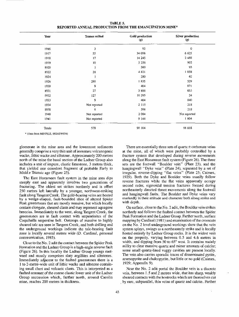
TABLE 5. REPORTED ANNUAL PRODUCTION FROM THE EMANCIPATION MINE*
Year Tomes milled Gold production Silver production (g) (g)
1916 1917 1918 1919 1920 1922 1924 1926 1930 I93 I 1932 1933 1934 1938 1940 1941
3 55 17 10
21 1
I 290
9 27
127 9
Not reported 8
Not reported Not reported
34 098 93
14 245 5 256
4 821 560
280 I 835
404 3 888
10 295 404
2 115 59 I
2 084 9 144
0 6 625 2 488
902 93
1058 62
529 87 I 653 24
840 218 218
Not reported I 804
Totals 578
* (Data from MINRLE, 092HSW034)
glomerate in the mine area and the lowermost sediments gener,ally comprise a very thin unit of immature volcanogenic wacke, lithic wackeandsiltstone. Approximately200metres north of the mine the basal section of the Ladner Group also
that yielded one conodont fragment of probable Early to includes a unit of impure, clastic limestone, 3 metres thick,
Middle Triassic age (Figure 25).
steeply east and apparently involves two generations of The East Hozameen fault system in the mine area dips
fracturing. The oldest set strikes northerly and is offset
fault along Tangent Creek. The gold-bearing veins are hosted 250 rnetres left laterally by a younger, northwest-striking
by a wedge-shaped, fault-bounded slice of altered Spider Peak ::reenstones that are mostly massive, but which locally contain elongate, sheared clasts and may represent aquagene breccias. Immediately to the west, along Tangent Creek, the greenstones are in fault contact with serpentinites of the Coqu.ihalla serpentine belt. Outcrops of massive to highly
the underground workings indicate the talc-bearing fault sheared talc are seen in Tangent Creek, and both drilling and
zone is locally several metres wide (D. Cardinal, personal communication, 1985).
Close to the No. 2 adit the contact between the Spider Peak Formation and the Ladner Group is a high-angle reverse fault (Figwe 26). In this locality the Ladner Group youngs east- ward and mostly comprises slaty argillites and siltstones. Immediately adjacent to the faulted greenstones there is a
ing small chert and volcanic clasts. This is interpreted as a 1 to 2-metre-wide unit of lithic wacke and siltstone contain-
faulted renlnant of the coarse clastic lower unit of the Ladner Grou]? succession which, farther north, around Carolin mine. reaches 200 metres in thickness.
43
90 104 18 818
at the mine, all of which were probably controlled by a There are essentially three sets of quartz t carbonate veins
fracture system that developed during reverse movements along the East Hozameen fault system (Figure 26). The three sets are the footwall “Boulder vein” (Plate 23). and the hangingwall “Dyke vein” (Plate 24), separated by a set of irregular, reverse-dipping “flat veins” (Plate 25; Cairnes, 1929). Both the Dyke and Boulder veins usually follow reverse fractures while the flat veins apparently occupy second order, sigmoidal tension fractures formed during northeasterly directed thrust movements along the footwall and hangingwall faults. The Boulder and Dyke veins vary markedly in their attitude and character both along strike and with depth.
northerly and follows the faulted contact between the Spider On surface, close to the No. 2 adit, the Boulder vein strikes
Peak Formation and the Ladner Group. Farther north, surface mapping by Cardinal ( I 98 1) and examination of the crosscuts on the No. 2 level underground workings show that the vein
hosted entirely by Ladner Group rocks. It is the widest vein system splays, swings to a northeasterly strike and is locally
on the property, varying between 0.5 and 4.6 metres in width, and dipping from 50 to 65” west. It contains mainly milky to clear massive quartz and minor amounts of calcite: some small quartz-lined vuggy cavities are present locally. The vein also carries sporadic traces of disseminated pyrite, arsenopyrite and chalcopyrite, but little or no gold (Cairnes, 1929; Appendix 9).
vein, between 1.5 and 2 metres wide, that has sharp, weakly Near the No. 2 adit portal the Boulder vein is a discrete
sheared contacts with the hostrocks which are themselves cut by rare, subparallel, thin veins of quartz and calcite. Farther

north, in the underground crosscuts, this single vein passes into a quartz stringer zone, 3 to 4.6 metres wide, consisting of a series of parallel, white quartz veins between 0.5 centimetre and I metre in width that are separated by horses of silicified Ladner Group hostrock (Plate 23). Most of
bedding in the Ladner Group. Locally the margins of the these stringer veins follow the slaty cleavage but crosscut
Boulder vein grade outwards into brecciated zones up to 3
LADNERGROUP
SILTSTONE
SILTSTONE WITH MINORARGILLITE
ARGILLITE
WACKE WITH MINORSILTSTONE
a VOLCANICGREENSTONE
SPIDER PEAK FORMATION
BRECCIATED GREENSTONE (AQUAGENE BRECCIA?]
/vsl .GABBRO
COOUIHALLASERPENTlNEBELT
LARGELY SERPENTINITE
Figure 25. Geology of the Emancipation mine area.
metres wide. These comprise angular, silicified, disorien- tated fragments of fractured Ladner country rock containing disseminated sulphides, set in a vein-quartz matrix. The
calcite, dolomite, siderite, gypsum, pyrrhotite and breccia matrix also contains minor to trace amounts of albite,
marcasite.
stones in the hangingwall of the Boulder vein are intensely Locally, particularly close to the No. 2 adit, the green-
silicified over widths of 1 to 4 metres and contain dis-
chalcopyrite, but no gold (Cardinal, 1981).. Drilling by seminated carbonate, pyrite, pyrrhotite, arsenopyrite and
\
Figure 26. Diagramatic vertical cross-section through the Emancipation gold mine (adapted after Cardinal, 1981).
dipping quartz stringer zone (centre and left) and quartz Plate 23. Emancipation mine - Boulder vein. Westerly
breccia (lower right). Crosscut on No. 2 level, Emancipation mine.
44

irregular subparallel veins and veinlets of quartz and/or calcite, 2 to 5 centimetres wide, that follow a chloritic shear 0.3 to 1 metre wide (Plate 24). These veins have sharp contacts; they dilate and split (Plate 24) and eventually pinch out entirely with increasing depth. They include both quartz-
gold (Appendix 9). The quartz-rich veins contain both turbid, rich and calcite-rich types, both of which sporadically carry
ribbon-textured quartz and some clearer vuggy quartz; small specks of visible gold were observed in the latter during this survey. The Dyke vein system also contains pink albite nodules (Cairnes, 1929) and gypsum. Disseminated pyrite and pyrrhotite are present in both the quartz veins and the sheared wallrocks, but the calcite veins are sulphide poor. The principal sulphides in the quartz veins, in decreasing order of abundance, are pyrrhotite, arsenopyrite, pyrite,
Plate 24. Emancipation mine - Dyke vein. Westerly chalcopyrite and marcasite. Caimes (1929) concluded that dipping, bifurcating quartz and quartz-carbonate veins along shear zone within basaltic greenstones of the Spider Peak
the pyrite and probably the pyrrhotite were the earliest
Formation. No. 2 level, Emancipation mine. sulphides and that they were succeeded by the gold and arsenopyrite; the Chalcopyrite may also have been contempo- raneous with the latter minerals. Cairnes also noted the local presence of enargite (Cu,AsS,) and spectacular amounts of free gold in the Dyke vein. The gold-silver ratio was repor- tedly 6: I ; recent assays on grab samples indicate gold-silver ratios varying from 2:1 to 9:1 (Appendix 9). The quartz, sulphide and gold contents decrease both down dip and along strike to the north.
quartz2 calcite veinlets, irregular lenses and stringer net- The flat veins (Plate 25) comprise numerous thin
works together with at least three more prominent quartz veins. They strike north to northwest, are from 0.5 to 20 centimetres wide and dip 20 to 45" easterly. They are
quickly pinch out with depth. Some of the veinlets exhibit splays from the overlying, gently inclined Dyke vein, but
quartz veins carry angular fragments of altered greenstone tension gash and pinch-and-swell features, while the larger
wallrock. The flat veins consist of white auartz with variable
vein. Easterly dipping flat veins (bottom and right) splaying Plate 25. Emancipation mine - flat veins and Dyke
out from the westerly dipping Dyke vein (upper left), both of which cut altered Spider Peak Formation greenstones. Note
vein. Lower stope on 3rd level, Emancipation mine. (Width - angular xenoliths of host greenstone within the lower flat
of lower flat vein is approximately 15 centimetres.)
Aquarius Resources Ltd. indicates that this hangingwall
pinches out down dip (Figure 26). alteratllon zone persists at depth, but the Boulder vein quickly
The hangingwall Dyke vein (Plate 24) was probably the most i:mportant source of ore as it was stoped for 85 metres
Bullis, 1971). Like the Boulder vein, it too strikes north but along strike and over 40 metres down dip (Cairnes, 1929;
differs in that it is narrower (generally between 1 centimetre and 60 centimetres wide) and its dip varies with depth. In the upper mine workings the Dyke vein dips 45" west, but with increasing depth the dip flattens progressively until the vein
ture. The Dyke vein system also varies in character along eventually forms a gently undulating, subhorizontal struc-
strike and down dip. On the upper levels it is represented by a single vein, up to 20 centimetres wide, within a strongly sheared, chloritic fault zone. At depth i t comprises several
amounts of calcite, plagioclase, gypsum and sulphides, together with some free gold. Both the quartz-rich and calcite-rich veins contain gold (Appendix 9) and carry some of the highest gold values encountered in the mine, par- ticularly close to where they intersect the Dyke vein (Cairnes, 1929; Bullis, 1971).
GEOCHEMISTRY OF THE MINERALIZATION
vein sets at Emancipation mine, and from the altered wall- A number of grab samples were collected from the three
rocks associated with the Boulder vein both on surface and underground. These were analysed for major and trace elements and the results are presented in Appendices 8 and 9.
alteration envelope were not auriferous while both the quartz- Samples collected from the Boulder vein and from its
rich and calcite-rich veins in the Dyke and flat vein systems are locally gold and silver bearing.
Both the flat and Dyke vein sets are sporadically enriched in arsenic and antimony, while anomalous tungsten values are recorded in all three vein sets (Appendix 9). However, an ultraviolet light survey of the underground workings revealed no evidence of scheelite in the veins. It is noteworthy that one sample of altered wallrock adjacent to the Boulder vein (sample GR 100) contains anomalous amounts of tellurium
45

(820 ppb) suggesting the possible presence of tellurides in the Emancipation hydrothermal system. Furthermore, the quartz-carbonate-sulphide alteration adjacent to the Boulder vein is enriched in sodium (up to 7.2 per cent N%O; Appendix 8) similar to the quartz-albite gold mineralization at the Carolin mine and the McMaster zone.
CONCLUSIONS ON EMANCIPATION MINE
The mineralization at the Emancipation mine includes two types that are probably genetically and temporally related. One of these is gold-sulphide-bearing quartz 2 carbonate veins in a reverse fault and complimentary tension fractures cutting Spider Peak greenstones. The second is a barren, siliceous carbonate-sulphide replacement of wallrock adja- cent to the margins of the generally barren Boulder vein. The gold is associated with erratic enrichment in arsenic, anti-
The zone of wallrock alteration is also depleted in potassium mony, tungsten and possibly tellurium, but not with mercury.
the albite-rich replacement gold mineralization at Carolin and enriched in sodium which suggests a possible link with
mine and the McMaster zone.
(Figure 25), which were not sampled during this survey, It is possible that the quartz veins near the Gypsy King adit
represent an offset southern extension of the Emancipation vein system. Consequently, the area between the Gypsy King adit and Tangent Creek warrants more detailed prospecting.
AURUM MINE (MINFILE 92HNW003) (PAST PRODUCER No. 2, FIGURE 23)
The old Aurum mine workings are situated on the north side of the Ladner Creek valley, approximately 300 to 350 metres south of the outcrop of the Carolin orebody (Figures 24 and 42). The deposit was discovered in 1927 when several shoots containing spectacular free gold were located within a talcose shear along the East Hozameen fault. Several adits were driven and sporadic production between 1930 and 1942 reportedly totalled 16.5 kilograms of gold from 494 tonnes of ore (Table 6); the gold-silver ratio was 5:l. Detailed studies of the deposit were not undertaken during this project, although the area around the workings was mapped (Figure 42) and some lithogeochemical samples were collected. Most of the following details are taken from Cairnes (1929),
who mapped the underground workings and described the geology and mineralization in some detail.
the Coquihalla serpentine belt to the west from either Ladner Near the Aurum mine, the East Hozameen fault separates
wackes or thin slices of Spider Peak greenstones to the east. In the mine area, this fault is a talcose shear that varies from “less than a foot to several feet” in thickness (Caimes, 1929). The shear is the principal host for the gold mineraliza- tion; the talc zone and its controlling fracture, the East Hozameen fault, have an undulating character dipping from northeasterly to southwesterly. Some narrow quartz veining is locally present within it.
associated with sulphides; in decreasing abundance, these Gold at the Aurum property is mostly free and is locally
copyrite and possible millerite. In places the sulphides are are pyrrhotite, pyrite and arsenopyrite, with traces of chal-
strongly oxidized to hematite and limonite, but early reports that the ore contained native mercury and cinnabar were not substantiated (Cairnes, 1929). The gold is not evenly distri- buted throughout the talc zone, but is concentrated in pockets and veinlets, often where arsenopyrite is abundant and con- spicuous amounts of quartz, carbonate and albite are present. Locally the gold and sulphides occur as polished films on
mineralizing event was followed by fault movements. The slickensided surfaces of serpentinite and talc, indicating the
free gold forms “plates, thin wedges, or irregular prongs”, as well as “small, roughly corrugated beads” (Caimes, 1929, page 154A). In some very rich ore the free gold is associated with thin arsenopyrite-rich bands interlayered with partings of calcite, quartz and foliated talc. Some gold also occurs as minute blebs distributed within the arseno- pyrite crystals, concentrated along the contacts between pyrrhotite and arsenopyrite, or between pyrrhotite and the gangue minerals. Cairnes concluded that the gold mineraliz- ation in the talcose shears is related to nearby gold-sulphide-
project revealed that zones of pronounced potassium deple- bearing quartz veins. Lithogeochemical sampling during this
tion and sodium enrichment are present on the Aurum property, similar to those overlying the Carolin deposit (Idaho zone) 300 metres farther north (Figure 33). Thus, introduction of the gold at the Aurum mine, like the Carolin
tion. This, together with the identical sulphides at both mineralization, was probably accompanied by some albitiza-
REPORTED ANNUAL PRODUCTION FROM THE AURUM MINE* TABLE 6.
Year Tonnes milled Gold production (g)
11 975 20 1 120
404 2 799
Silver production (!3)
1930 59 1931 1932 7 1939 227 1942 181 280 Not reported
Not reported
2 737 156 124
Totals 494 16 578 3 017
* (Data taken from MINFILE. 092HNWW3.)
46

properties (abundant pyrrhotite and pyrite, sporadic arseno- pyrite and trace chalcopyrite), suggests the mineralization at the Au:rum and Carolin mines is genetically and temporally related.
CAROILIN MINE (MINFILE 92HNW003 AND 007) (PAST PRODUCER NO. 3, FIGURE 23)
The Carolin gold mine is located about 20 kilometres northeast of Hope (Figure 2) on the northwest side of Ladner Creek at an approximate elevation of 1070 metres (3500 feet) above sea level. The deposit represents mesothermal epi- genetic mineralization that is characterized by the introduc- tion of gold with abundant sulphides, albite, quartz and carbonate. It is hosted by metasedimentary rocks of the Ladner Group close to both their unconformable contact with greenstones of the Spider Peak Formation and their faulted contact with ultramafic rocks of the Coquihalla ser- pentine belt (Figures 24 and 42).
staked in 1915. The surface showings of the Idaho zone, the The property (originally called the Idaho claims) was first
gold deposit which later supported the Carolin mine opera- tion, were originally described by Cairnes (1929). In 1945 and 19,$6, eight shallow diamond-drill holes were put down in the Iljaho zone; they intersected mineralization grading 5.8 grams ;gold per tonne over an average width of 5.4 metres. In 1966, trenching by Summit Mining Ltd. extended the surface showingsforastrikelengthof75metres.In1973,theLadner Creek ]property was purchased by Carolin Mines Ltd. which conduc:ted a major exploration and drilling program, and by the end of 1974 the mining potential of the Idaho zone was realized. Underground diamond drilling and bulk sampling of the Idaho zone were carried out from an exploration decline: in 1977 and 1978, and the mill, with a design capacity of 1360 tonnes per day, was completed in 1981 (Plate I.). Milling began in December 198 1, and the first dor6 bar wa:; poured in February 1982. Mining was by open-stope blast-hole methods taking vertical slices from longhole rings placed 1.5 metres apart. Further details on the initial mining methods and milling procedures are given by Samuels (1981).. At the time of initial development, reserves in the Carolin deposit were estimated at 1.5 million tonnes grading 4.4 grams per tonne gold (at a cut-off grade of 2.7 grams per tonne). However, production data (Appendix 10) indicate less than 800 000 tonnes grading 3.2 grams per tonne were mined. During its three years of operation, Carolin mine produced a total of 1354 kilograms of gold from 799 119 tonnes of ore; the annual mining and gold production statis- tics are given in Appendix 10 and Figure 27. During the life of the :mining operation there were several periods of shut-
recoveries. Gold recoveries for 1982, 1983 and 1984 aver- down resulting from environmental concerns and poor gold
other difficulties resulted in the the closure of the mine at the aged only 33,60 and 61 per cent respectively and these and
end of 1984.
GEOLOGY OF THE CAROLIN MINE AREA
The surface geology around Carolin mine is shown on Figure 42. To the east are metasedimentary rocks of the
I CAROLIN MINETOTALGOLD PRODUCTION FROM JANUARY. 1882-SEPTEMBER 1984 = 1354KlLOGRAMS
from Carolin mine between January 1982 and September Figure 27. Histogram showing monthly gold production
1984.
Ladner Group and massive to pillowed volcanic greenstones of the Spider Peak Formation. These are separated from serpentinites of the Coquihalla serpentine belt farther west by the East Hozameen fault. The gold-bearing Idaho zone, which forms the Carolin deposit, outcrops approximately 150 metres east of this structure. The contact between the older Spider Peak Formation and the Ladner Group is not exposed in the immediate mine area. Consequently the existence of a basal conglomerate in the Ladner Group at the mine is unproven, although it is exposed elsewhere in the district. The Ladner Group succession at Carolin mine con-
200 metres thick, which is overlain in turn by a middle unit of sists of a heterogeneous, coarsely clastic lower unit,
siltstone, approximately 200 metres thick, and an upper slaty argillite unit more than 1000 metres thick (Figure 28). Graded bedding is widespread in the siltstones and wackes; other less common features include crossbedding, flame structures, chaotic slumping and rip-up clasts.
coarse clastic unit of the Laduer Group succession, approx- Gold mineralization is hosted in the lower heterogeneous
imately 150 to 200 metres stratigraphically above the uncon- formable contact with the Spider Peak Formation (Figure 28). The lower unit includes discontinuous wedges of interbedded greywacke, lithic wacke, sedimentary breccia and conglom- erate, together with intercalated sequences of siltstone and minor argillite. The lithic wackes contain variable amounts of angularrockand mineral fragments averaging 1 centimetre in diameter. Basic and intermediate volcanic clasts predominate although some quartz, carbonate and feldspar fragments, and rare clasts of altered acid volcanic rock, are also present. Sedimentary breccias and polymictic conglomerates, gener- ally up to 30 metres thick, are present in the lower unit. They vary from densely packed, clast-supported sedimentary brec- cias with angular lithic fragments, to conglomeratic mudstones containing isolated, well-rounded pebbles, cob-
47

PIPESTEM MINE + WACKE-
"ARGILLITE
................ ................. ................ ................. ................ ................. ................. ................ ................. ................ .................
................
CAROUN MINE d
-SILTSTONE - CONGLOMERATE
"_
".
THICKNES: (METRES1
lOOO+
. - - - - - -
200
0-10
l0
15-20 5-10
0-50
30-50 0-10
COQUIHALLA SERPENTINE BELT
V V V V I C E M A N C I P A T I O N MINE
'~ERPENTINITE A N D GABBRO 0-2000
3 ,
>
4
>
-<
>
. -
UPPER UNIT
MIDDLE UNIT
LOWER UNIT
U_N>OflFSEMTy
LADNER GROUP (LOWER TO UPPER JURASSIC1
SPIDER PEAK FORMATION I? LOWER TRIASSICI
~~~~~~~~~ ~~~~~~~ ~~ ~~~
Figure 28. Stratigraphy in the Carolin mine-Spider Peak area showing relative stratigraphic position of the Emancipation, Aurum, Carolin and Pipestem gold deposits.
hles and boulders up to 30 centimetres in diameter. The clasts are set in a mudstone or siltstone matrix which often displays soft-sediment disruption and chaotic slumping. One con- glomeratic unit in the mine district reaches 50 metres in thickness and is traceable for 1.5 kilometres along strike. It exhibits an overall reverse grading; its lower section consists of a densely packed, green-coloured breccia which passes
containing rounded cobbles and boulders. The clasts in the stratigraphically upwards into a conglomeratic mudstone
mudstone are predominantly altered basalt with lesser amounts of chert, gabbro, diorite, granite, granodiorite, porphyritic andesite, flow-banded dacite and limestone. Conodont microfossils of Middle to Late Triassic age were extracted from one limestone boulder within a conglomeratic mudstone outcropping approximately 250 metres north of the
Idaho zone (M.J. Orchard, written communication, 1986; Geological Survey of Canada Location No. C-103719).
mainly of grey to black, generally well-hedded siltstone The middle sedimentary unit of the Ladner Group consists
(Figure 28). Beds vary from 1 to 10 centimetres in thickness (Plate 15) and are commonly graded.
The slaty argillites in the uppermost unit are black to grey, generally unbedded rocks that are locally pyrite and organic rich; they are composed mainly of very fine grained quartz, altered plagioclase and chlorite with variable amounts of sericite, carbonate and exceedingly fine grained, opaque organic material. Cleavage is defined by the subparallel alignment of chlorite and sericite, and elongate growth of the quartz and pyrite crystals.
48

to brecciated greenstone outcrop north and south of the Two elongate, fault-bounded'slices of gabbro and massive
surface exposure of the Idaho zone (Figure 42). These rocks vary fromfine grained andequigranular to coarsely porphyri- tic. During the mapping program it was uncertain whether they represented intrusions or thrust slices of Spider Peak Formation; the latter interpretation is now accepted. The
tated euhedral to subhedral phenocrysts of andesine plag- porphyritic gabbros in these slices contain randomly orien-
ioclase set in a chlorite-plagioclase (An3& matrix. The phenocrysts are zoned, corroded and strongly altered, and exhibit good albite-carlsbad twinning. The groundmass comprises strongly altered plagioclase (up to 30 per cent), together with abundant chlorite (up to 40 per cent) which occurs in disseminations, clots and veins. The groundmass also contains up to IO per cent tremolite- actinolite, as well as variable amounts of epidote, clinozoisite, carbonate, sericite and minor albite. Some greenstones in these slices contain clots of carbonate and chlorite that replace primary vesicles. Late, randomly orien- tated flakes of stilpnomelane are also present locally; this
to microfractures. Locally, the rocks in these thrust slices are mineral is usually found in chloritic alteration zones adjacent
mineralized, being overprinted with albitic and sulphide alterat.ion, crosscut by quartz veins, and sporadically auriferous (Appendix 7D). Like the Spider Peak Formation adjacent to the Coquihalla serpentine belt elsewhere, the fault-bounded slices of volcanics and gabbros at Carolin mine are en:riched in sodium (Appendix 7C).
The East Hozameen fault dips steeply northeast and sharply crosscuts the Ladner Group stratigraphy in the mine area (Section 1-2, Figure 42). Graded bedding in the Ladner Group reveals that most of the stratigraphic sequence, includ-
Consequently, the Spider Peak Formation which lies adjacent ing th,at hosting the Idaho zone, is structurally overturned.
to the East Hozameen fault now tectonically overlies the stratigraphically younger Ladner Group (Figure 42).
Mo,jt of the post-ore faults strike northwest (Figure 42), subparallel to the East Hozameen fault and the regional slaty cleavage. However, a younger set of east-northeast-striking normal faults is also present: this includes the northerly dipping Richardson fault which truncates the Idaho zone.
GEOLOGY AND MINERALOGY OF THE CAROLIN DEPOSIT
faulted and altered zone up to 40 metres in outcrop width. It is The surface expression of the Carolin deposit is a strongly
charac:terized by secondary manganese and iron oxides,
dense network of irregular, variably deformed quartz-carbon- intense albitic alteration, disseminated sulphides, and a
ate veins (Plates 26, 27 and 29). The sulphide-albite-quartz-
permeable, competent rocks such as wackes, lithic wackes, carbonate mineralization is preferentially hosted by the more
conglomerates and siltstones while the thin units of slaty argilli1:e in the mine sequence are generally unmineralized.
the gold mineralization were poorly understood. Surface During the first year of mining, the geological controls of
geological mapping over the deposit (Ray, 1982) revealed the presence of numerous upright and asymmetric, large and small-scale D, folds (Plate 22) and it was speculated that the
Plate 26. Carolin mine. Weathered boulder of gold- sulphide-albite-carbonate-bearing ore from the Idaho zone with quartz veining enveloped by disseminated carbonate alteration. Outside Idaho adit.
albite veining associated with Idaho zone mineralization. Plate 27. Carolin mine. Multistage deformed quartz and
Underground, 900 slot crosscut.
coarse-grained, third generation albite with deformed twin Plate 28. Carolin mine. Photomicrograph (X Nicols) of
planes and some late carbonate. Underground, 900 slot CIOSSCUt.
49

geometry of the deposit was influenced by these structures. Subsequent underground mapping demonstrated that the mineralization is both lithologically and structurally control- led (Shearer and Niels, 1983); mineralization is preferen-
grained Idaho zone sulphide-albite-quartz-gold-bearing Plate 29. Carolin mine. Photomicrograph (PPL) of fine-
wacke cut by late, deformed quartz veins. Underground, 900 slot crosscut. Carolin mine.
LEDEND ~~:,.::~~~~~~~."..",.. -.... ~ S I L T m M
ow.... -UT"IC WAClE a ..: PSBBLE .BO"LI)IR CoNOLOMInATE
Figure 29A. East-west geological cross-section of the Carolindepositat766North.showinglocationoftheNo. 1,2 and 3 orebodies (adapted after Shearer and Niels, 1983).
tially concentrated in the more permeable, competent sedi- mentary beds within the hinge of a complex D, antiformal fold (Figures 29A and 29B). A boulder and pebble con- glomerate marker horizon within the Ladner Group was recognized underground (Figure 29A) which may correlate with the distinctive green breccia and conglomeratic mudstone unit mapped on surface (Figure 42).
A geological cross-section across the Carolin deposit is shown on Figure 29A. The deposit plunges gently northwest, subparallel to the plunge of the D, fold axes in the area. The ore amenable to longhole open stoping is located in the thickened region of the fold hinge, while mineralization on the fold limbs tends to be too narrow for profitable mining. At least three saddle-shaped orebodies have been outlined to date, an upper No. 2, a middle No. I and a lower No. 3 orebody (Figures 29A and 29B). Deep drilling has shown several additional auriferous zones are present below the No. 3 orebody.
ferences between the No. 1 and No. 2 orebodies, and the There are significant mineralogical and geochemical dif-
deposit as a whole exhibits a vertical mineralogical zoning. Shearer (1982b) concluded that the upper No. 2 orebody is pyrite-rich, while the lower No. 1 orebody is pyrrhotite-
to that described in other gold deposits such as the Mount dominant. This vertical pyrite to pyrrhotite zoning is similar
\ \ No. 2 OREBODY I /~.\V
0 Gold-Sulphide mineralim4oo I l d a h o r o n e l
0 u"m;"emli& sedimemaly mcks
Drill hole
Figure 29B. East-west cross-section through the Carolin deposit at 837 North showing locations of drill holes lU49 and IU53, and auriferous zones A, C and D (after Ray et al . , 1986).
50

Charlotte in Western Australia (Phillips e ta l . , 1983) and the McIntyre mine in Ontario (Langford, 1938). The No. I orebody at Carolin mine is hosted mainly by greywacke and has exl:remely uniform gold grades while the No. 2 orebody has a siltstone host and is characterized by erratic gold values. This probably reflects differences in the original permeability of the hostrocks. Little is known about the deep No. 3 orebody except that it resembles the overlying No. 1 orebodyy in its mineralogy and hostrock lithology. The gold- silver ratio in the deposit as a whole averages 1: 10, but varies from I : ] to 1:22.
The Carolin deposit is cut by numerous northerly striking faults '(Figure 29A), some of which contain carbonaceous material. The deposit is also truncated on the north by the younger, easterly striking and northerly dipping "hanging- wall shear". No mining has taken place north of the shear, and the location of the postulated down-plunge extensions of the orebodies across it is unknown. The shear may be the downward continuation of the Richardson fault mapped on surface (Figure 42); the latter is probably a normal fault which suggests that the northerly extension of the deposit is downthrown to the north.
carbonate mineralization include wackes, pebble conglom- Lithologies favourable for gold-sulphide-albite-quartz-
erates and siltstones. Coarse-grained, pervasive albitization
wallrocks. However, the exceedingly fine grained chloritic is present throughout both the ore zones and the adjacent
and sericitic alteration related to the mineralizing event is generally well developed in the surrounding wallrocks, but not so abundant in the ore. The ore consists largely of quartz and albite (An3.5), with variable amounts of carbonate, chlorite, very fine sericite and opaque minerals; it is cut by numerous irregular veins of albite, quartz and carbonate. The opaques range from 1 to 15 per cent by volume and average 6 to 8 per cent; they are mainly pyrrhotite, arsenopyrite, pyrite and magnetite. Less common opaques, in decreasing abundance, include sporadic traces of chalcopyrite, bornite,
generally form coarse euhedral to subhedral crystals (Figure gold and sphalerite (Kayira, 1975). Pyrite and arsenopyrite
30). while pyrrhotite and magnetite occur as finer grained disseminations and clusters. Kayira concluded that the para-
pyrite, '(3) pyrite, (4) gold, (5) pyrrhotite, (6) sphalerite and genesis of the opaque minerals was ( I ) magnetite, (2) arseno-
(7) chalcopyrite; a partial overlap in the deposition of arseno- pyrite, pyrite and pyrrhotite was noted. However, Shearer
rich zones presented the following paragenesis: (1) magne- (1982b) in his study of both the pyrite-rich and pyrrhotite-
tile, (2) arsenopyrite and some gold, (3) contemporaneous deposition of pyrite, pyrrhotite and some gold, (4) minor magnetite and finally (5) traces of chalcopyrite and gold.
first generation material; it forms small, disseminated, rec- The majority of the magnetite in the ore represents early,
tangular grains and is probably unrelated to gold mineraliza- tion as it shows no spatial association with either gold or sulphidas. Arsenopyrite is the earliest sulphide associated with gold. Some arsenopyrite crystals are partly rimmed with small blebs of pyrite and pyrrhotite, while the euhedral pyrite
rhotite iis magnetic and often contains exsolution rods of crystals locally include small grains of pyrrhotite. The pyr-
pyrite. Shearer notes the presence of minor, second genera-
tion magnetite related to gold mineralization and associated with pyrrhotite and arsenopyrite. Gold generally forms very small grains up to 0.02 millimetre in size, commonly as inclusions within the pyrite and arsenopyrite or rims on the pyrite, pyrrhotite and chalcopyrite (Figure 30). Some gold and chalcopyrite rim pyrrhotite. Minute grains of gold also occur within or along grain boundaries of some quartz, carbonate or albite crystals. Although visible gold is uncom- mon throughout the Idaho zone, it is present as thin plates and smears on some fault surfaces. Rarer forms of visible gold include leaf-like masses, small scales and rods.
Rocks in the Idaho zone are commonly pale coloured, largely due to weak silicification and intense pervasive albitic
Field Of view 0.59 mrn X 300
the 925 Level, south slot crosscut, Carolin mine (from Figure 30. Drawings of polished ore sections taken from
Shearer, 1982b). As = arsenopyrite: Po = pyrrhotite; Mt = magnetite; Ch = chalcopyrite; Au = native gold.
51

and carbonate alteration. The auriferous zones are generally
and 29) and disseminated sulphides, although not all areas associated with albite and quartz veining (Plates 26, 27, 28
containing these features are necessarily enriched in gold. Widespread albitization produces a sodium-rich envelope that extends hundreds of metres from the deposit. There are at least three generations of albitization. The earliest is fine grained and was probably coeval with sulphide-gold-quartz mineralization; this early albite is weakly altered and dis- seminated throughout the ore, being intimately intergrown with sulphides and fine quartz crystals. It is cut by numerous thin, deformed veins of poorly twinned, second generation albite. The youngest albite forms veinlets, disseminations
coarse, fresh, well-twinned crystals (An,.,) up to 8 milli- and irregular masses throughout the ore zone, comprising
metres in length with locally deformed twin planes
rich ore are brecciated and entirely engulfed by third genera- (Plate 28). In places, small angular fhgments of sulphide-
tion albitic material. The deposit is also cut by numerous white quartz-
carbonate veins, generally less than 15 centimetres wide, which form a complex, irregular network (Plates 26 and 27). Sigmoidal gash fracturing, and the variation in vein deforma-
recurrent structural deformation, and at least three phases of tion, suggest that multistage quartz injection occurred during
quartz vein injection are recognized. Many of the early veins are folded (Plates 27 and 29); they contain strained quartz crystals elongated parallel to both the D, fold axial planes and the slaty cleavage, and are interpreted to be either older or contemporaneous with the D, deformation. Quartz crys- tals in the younger veins are generally unstrained and grauo-
bly coeval with the gold mineralization and they are com- blastic. Some of the earlierquartz-carbonate veins are proba-
manly associated with the introduction of disseminated car- bonate which may form pervasive halos around the veins
postdate the introduction of the gold, sulphides and albite; (Plate 26). However, most of the veins appear to immediately
some contain minor amounts of albite and clinozoisite, as
physical characteristics suggesting a maturation equivalent to well as minute flakes of pyrobitumen, with optical and
meta-anthracite (Y.J. Kwong, written communication, 1983). In rare instances, small amounts of finely dissemi- nated carbon are also present in the altered wallrocks imme-
tions of calcite and ankerite are also widespread in the Idaho diately adjacent to quartz veins. Late veins and dissemina-
carbonate veining is generally not folded. zone; unlike the earlier albite and quartz veining the late
Studies of fluid inclusions from various quartz veins in the Idaho zone suggest the presence of three generations of low- salinity, C0,-rich fluids with homogenization temperatures of approximately 320"C, 225" to 275°C and 150" to 190°C respectively (J.B. Murowchick, University of Alberta, writ- ten communication, 1985). Nesbitt er al. (1986) conclude from oxygen isotope studies that emplacement of quartz veins in the deposit involved deeply circulating meteoric
enriched in 6D relative to local meteoric water. Their work waters that were highly enriched in ' 8 0 and .somewhat
also suggested that the serpentinites in the Coquihalla serpen- tine belt adjacent to the mine were affected by these fluids.
Although the mineralization at Carolin mine is probably contemporaneous with the regional D2 deformation, a post-
52
Middle Cretaceous to pre-Late Eocene event (J.W.H. Monger, verbal communication, 1986), its precise age is unknown. However, in its setting, mineralogy and wallrock
Coquihalla gold belt exhibit many similarities to the Bralome alteration, the Carolin deposit and other occurrences in the
deposit in the Bridge River camp which has been dated between 91 and 43 Ma (Leitch and Godwin, 1988). More- over, the Bridge River camp is associated with the Cad- wallader fault which may form part of the Yalakom fault
of the Hozameen fault (Monger, 1985). Thus the mineraliza- system; the latter could represent a northwesterly extension
may have been coeval and originally adjacent; subsequent tion in the Bridge River camp and the Coquihalla gold belt
during early transcurrent movements along the Hozameen- separation of the two mineralized areas possibly occurred
kilometres of dextral offset followed by later offset along the Yalakom fault system that resulted in approximately 70
Fraser faults.
GEOCHEMISTRY OF THE NO. 1 AND NO. 2 OREBODIES
The geochemistry of several ore zones in the Carolin deposit was studied by analysing 50 core samples from drill holes IU49 and IU53. These inclined holes were drilled from underground and totalled 130 metres in length. Hole IU49 was 35 metres long and drilled upwards (Figure 29B); it intersected the entire pyrite-rich No. 2 orebody. Hole IU53 was drilled downwards and cut a repeated hangingwall sec- tion of the underlying pyrrhotite-rich No. 1 orebody (Fig-
determine the variations in major and trace element content ure 29B). The objectives of this geochemical study were to
observed mineralogical changes. The analytical results for throughout the holes and compare these variations to
holes IU49 and IU53 are presented in Appendices 1 lA , 11B and 11C.
Four sulphide-rich auriferous zones were intersected whicharedesignatedzonesA,B,CandD(Figures29B,31A and 31B). The 9-metre-wide Zone A represents the No. 2 orebody intersection, while zones B, C and D, which total 18 metres in thickness, are structural repetitions of hangingwall portions of the No. 1 orebody. Pervasive albitization and
holes, in both the ore zones and the surrounding hostrocks. sporadic carbonate alteration are evident throughout the drill
However, the ore zones are distinguished mineralogically by the general abundance of sulphides and quartz veining, while the adjacent wallrocks are marked by intense chloritic and sericitic alteration.
The downhole variation of selected elements is shown on Figures 31A and 31B. In addition to the elements shown, analyses were completed for Cu, Hg, Sb, Pb, CO,, P205, A1,0,, TiO,, MnO and total iron (expressed as Fe,O,)
anomalous (up to 310 ppm) in some mineralized zones. Lead (Appendices 1 IA, 1 lB, and 1 IC). Copper was very weakly
consistently showed enrichment (up to 20 ppm) in the hang- and strontium showed no anomalous values, while antimony
ingwall portions of all four gold-hearing zones.
cal results and correlation matrices indicate that the gold in Univariate statistics were determined from the raw analyti-
the ore has a positive correlation with Na,O, CaO, S, Sb, Mo, Cu, As and Ag, and a negative correlation with A1,0,, H,O and BaO. No statistically significant correlation between Au andSiO,,Fe,O,,TiO,,MnOorPbisapparent.IntheNo.2

L
Figure 31A. Geology, trace element geochemistry and K,OlNa,O ratios of holes 11149 and IU53, Carolin mine.
Figure 31B. Geology and major element geochemistry ofholes 1U49 and IU53, Carolin mine. Note auriferous zones A, B, c and D
53

orebody (Zone A, Figure 31A), the gold and silver are preferentially concentrated at the footwall and hangingwall
obvious. The hangingwall section of this orebody is also and a positive correlation between the two elements is
associated with anomalous molybdenum and arsenic (Figure 3 1A); by contrast, zones B, C and D in the No. 1 orebody do not contain silver or molybdenum, although they are charac- terized by high gold and arsenic values.
Compared to unmineralized Ladner siltstones and wackes outside the mine area, which average approximately 2.5 to 4
hole section is enriched in sodium (Figure 31Aj. Increases in percentNa,O(Rayetal.. 1986),mostofthe 130-metredrill-
sodium generally correspond with decreases in potassium, suggesting that albitization led to the breakdown and removal of the original potassium feldspar in the rocks. The close association between albitization and mineralization is illus- trated by the sharp decrease in K,O/Na,O ratios as the ore zones are approached (Figure 31A).
Auriferous zones A, B and C are surrounded by potassium and barium depletion envelopes that are generally twice as
between the two elements suggests that the barium was wide as the associated ore zones. The positive correlation
originally contained within potassium feldspar. All four auriferous sulphide-rich horizons show increases in sulphur and decreases in water (Figure 3 1B); the latter may reflect the lower chlorite and sericite content of the ore compared to the wallrocks. Higher levels of magnesium and potassium in the adjacent wallrocks mark areas of more intense chloritic and sericitic alteration. The entire wallrock section drilled between the No. 1 and 2 orebodies is intensely chloritic and generally marked by increased magnesium values (Figure 31B). This chloritic envelope is separated from the 'No. 1 orebody by athin (2 to 3 metre) zone which is chlorite- poor, but contains abundant quartz veining.
bearing zones A, B and C shows many common characteris- The distribution of elements within and adjacent to gold-
tics, hut the two samples from Zone D in the lowermost part 'of the No. 1 orebody are geochemically unusual. Mineraliza- tion in Zone D is associated with a decrease in S O , and
reflects geochemical differences in the original sedimentary increases in CaO, BaO and K,O. It is uncertain whether this
hostrock, or whether the pyrrhotite-rich No. 1 orebody contains two mineralogically and geochemically distinct zones.
GEOCHEMICAL ENVELOPES ASSOCIATED WlTH THE CAROLIN DEPOSIT
Seventy-two lithogeochemical samples of Ladner Group wacke and siltstone were systematically collected from a wide area around the Carolin deposit to determine whether
mineralization; the locations of the samples are shown on large-scale elemental zoning is associated with the gold
Figure 32. They were analysed for a number of major and trace elements; the analytical data are given in Appendices 12A and 12B and the univariate statistical results are pre- sented in Appendix 13. A correlation matrix (Appendix 14) indicates that gold has a strong positive correlation with As, CaO, Ag, Cu and Na,O, and a strong to moderate negative correlation with SiO,, K,O and Ba. Loss on ignition, which mostly represents CO, (Appendix 12A) also has a strong sympathic relationship with gold.
Mo, Cr, Hg, Sb, Bi, Cd and Sr show little or no systematic The study revealed that TiO,, MnO, Cu, Pb, Zn, Co, Ni,
change in concentration throughout the sampled area, and are not apparently influenced by the gold mineralization. Failure to detect increased values of antimony and copper above the
distribution of these elements within the ore. However, some deposit is probably due to the low concentration and sporadic
MgO and CaO, showed systematic variation patterns and other elements, notably Au, As, BaO, K,O, Na,O, S O 2 ,
form enrichment or depletion zones within or around the deposit.
The surface exposure of the Carolin deposit is outlined by a lithogeochemical gold anomaly measuring 40 by 80 metres
present in the ore, forms a weaker anomaly (500 to 18 200 (Figure 33B). while arsenic, which is only sporadically
ppm As) only 50 metres in length (Figure 33Aj. Elongate zones of calcium enrichment (Figure 33E) and barium (Fig- ure 33C), silica (Figure 33D) and magnesium depletion also correspond with the deposit. The increase in calcium values reflects the presence of carbonate veins and disseminations in the ore, while the barium depletion zone (<IO0 ppm BaO) probably results from breakdown of potassium feldspar dur- ing the mineralizing process. Despite quartz veining in the ore, the samples collected in this study show that the deposit is associated with silica depletion (38 to 53 per cent SiO,) relative to the country rocks (53 to 69 per cent SO,). However, this may reflect a sampling bias as the relatively
intensely quartz-veined hostrocks were not collected for small size of each sample meant that both quartz veins and
cent to 5 per cent MgO) is generally higher than that in the analysis. The magnesium content of the hostrocks (2.5 per
deposit (0.6 to 2.5 per cent MgO). The elevated magnesium content is believed to reflect the wide envelope of chloritic alteration that surrounds the deposit.
lous envelopes around the deposit (Figures 33F and G). Potassium and sodium display the most extensive anoma-
mine area average 1.5 to 2 per cent K,O and 2.5 to 4 per cent Siltstones and wackes from the Ladner Group outside the
Na,O (Ray et al., 1986), while similar rocks from the mineralized zones contain between 6 and 10 per cent N % 0
The Carolin gold deposit is surrounded by a zone of and generally less than 0.4 per cent K,O (Appendix 12A).
potassium depletion measuring 150 by 250 metres (Fig- ure 33F), and a sodium enrichment envelope approximately 500 metres long and 300 metres wide (Figure 33G). Unlike many other epigenetic gold deposits (Boyle, 1979), mineral- ization is associated with a sharp decrease in K,O/Na,O ratios (Figures 31A and 33H).
except sodium, are sharply truncated by the easterly striking All zones of geochemical depletion and enrichment,
Richardson fault. However, both the sodium enrichment and chloritization envelopes related to the Carolin orebodies extend north of the Richardson fault (Figures 33G and 34) which may indicate the presence of a downthrown, down- plunge, northerly extension of the deposit.
MINERAL ALTERATION AROUND THE CAROLIN DEPOSIT
collected for the lithogeochemical study revealed that the Detailed thin-section examination of the 72 rock samples
54

NEW MONTANA
SCALE METRES
THOGEOCHEMICALSAMPLE LOCATION AND SAMPLE NUMBERS. . . . . . . . . . . . . . . . 606
)AD . . . . . . . . . . . . . . . . . . . . . . . . . . . . .
EEK . . . . . . . . . . . . . . . . . . . . . . . . . . . -+
DITPORTAL. . . . . . . . . . . . . . . . . . . . . . . . . . <
POGRAPHIC CONTOUR IELEVATION IN FEETI. . . . . . . . . . . . . . "3400-
Figure 32. Location of 72 lithogeochemical samples collected at Carolin mine.
55

. sarno1e Locati"" c \ .
s \ \
.
S"\
s \\ .
lithogeochemical samples of Ladner Group rock. A = arsenic; B = gold; C = barium; D = silica; E = calcium; F = potassium; G = Figure 33. Element zoning associated with the Carolin mine deposit. Hand-generated contoured plots of 72 surface
sodium; H = potassiudsodium ratios. S = Coquihalla serpentine belt; V = Spider Peak formation; EHF = East Hozameen fault.
56

E
s "\ -

Carolin deposit is surrounded by an elongate, discontinuous envelope of mineral alteration up to 200 metres wide and 600 metres long that variably overprints the Ladner Group hostrocks. Four concentric zones of alteration are recognized (Figures 34 and 35A). These have gradational boundaries with one another and are variable in width. They are charac- terized by different mineral assemblages andlor mineral textures and are designated from outermost to innermost as zones I , 2 , 3 and 4. The two inner alteration zones (3 and 4) are intimately associated with each other and are restricted in area; the intense, coarse-grained nature of the alteration
the two outer alteration zones (1 and 2) are more extensive makes it easily identifiable in hand specimen. By contrast,
ZONES 3 and 4 : COARSE, PERVASIVE ALBITIZATION t SULPHIDES,QUARTZ VEINING,ANDGOLD(uiribleinoutcrop) a ZONE 2: MODERATE TO INTENSE CHLORITIZATION AND ALBITIC PORPHYROBLASTS*SERlClTE
ZONE 1 : WEAK TOMODERATE CHLORIlIZATIONfSERlClTE
0 WEAK CHLORITIZATION DUE TOREGIONAL GREENSCHIST
APPROXIMATE OUTER LIMIT OF ZONE 1-TYPE ALTERATlON."---"
THIN SECTION SAMPLE . NOTE: ZONES 1 AND2 ARE IDENTIFIABLE ONLY IN THIN SECTION
METAMORPHISM
ciated with the Carolin deposit (hand-generated contouring Figure 34. Distribution of mineral alteration zones asso-
from thin section modal estimates). S = Coquihalla serpen- tine belt; V = Spider Peak formation.
(Figure 34). but the alteration is finer grained and generally only recognizable in thin section. Consequently the existence of alteration zones 1 and 2 was not recognized during the initial geological mapping around the deposit (Ray, 1983; Shearer and Niels, 1983).
Zone 1, the outer and most extensive alteration envelope
outer limits cannot be precisely defined due to the variable (Figure 34), is characterized by pervasive chloritization. Its
chloritic alteration associated with the regional greenschist facies metamorphism in the district. Generally, the original clastic grains of twinned plagioclase (An25.35) are clearly recognizable in the regionally metamorphosed Ladner Group wackes and siltstones outside the mine area. Within Zone 1, however, detrital quartz is generally the only recognizable original component. The groundmass in these rocks is par- tially or completely replaced by fine-grained chlorite and the original feldspars are altered to exceedingly fine grained
Zone 1 is rimmed or replaced by leucoxene, and actinolite is sericite, kaolinite, epidote and carbonate. Ilmenite within
present in minor quantities (Figure 35A).
alteration is marked by the crystallization of fine-grained Zone 2 reaches 75 metres in width (Figure 34) and the
quartz, plagioclase, actinolite and epidote, and extensive
characteristic feature of Zone 2 is the appearance of isolated chloritization and sericitization of the groundmass. One
porphyroblasts of twinned albitic plagioclase (An3.,J up to 0.5 millimetre in length within the fine-grained chloritic and
L
"""_"""""""" / I ""_ / I
""""""".""" /I
I B llMl * I Figure 35. A: Schematic illustration of the four zones of
mineral alteration associated w i t h t h e Carolin orebody. B: Paragenesis of the mineral alteration assemblages associated with the Carolin orebody.
58

sericitic groundmass; these porphyroblasts are partially replaccd by late sericite and carbonate. Original detrital quartz grains are still recognizable but locally the rocks contain recrystallized, fresh quartz, elongate parallel to the foliation.
The transition from Zone 2 to Zone 3 is marked by a decrease in chlorite and sericite, and an increase in both the albite content and mineral grain size (Figure 35A). Zone 3 alteration extends up to I 5 metres beyond the orebodies; albitization is pervasive and also occurs as veins; it increases in intensity toward the ore contacts. Locally the rocks are cut by quartz and carbonate veins, and contain carbonate disseminations.
Zone 4 is the central and least extensive alteration type and essentially confined to the orebodies themselves. Like Zone 3, i t is marked by intense albitic alteration and quartz veining, but is distinguished by the presence of up to 15 per cent sulphides, which include pyrrhotite, pyrite and arseno- pyrite. Locally these rocks carry disseminations and veins of calcite and ankerite. Minor chlorite is widespread and sericite replacement along fractures is common locally. Although these rocks are sodium-rich, x-ray studies have not detected paragonite (Y.J. Kwong, written communication, 1986).
Figure 35B: thin-section studies suggest the following gen- The paragenesis of the alteration assemblage is shown on
era1 sequence: (1) chloritization together with some sericitiz- ation ,and weak kaolinization; ( 2 ) the introduction of quartz, albite, sulphides and gold, (3) continuing introduction of
quartzicarbonate veins with local envelopes of dissemi- albite and quartz, (4) emplacement of multiple phases of
nated carbonate followed by ( 5 ) the late emplacement of veins and disseminations of calcite and ankerite. Weak sericitization and chloritization apparently took place throughout the entire sequence (Figure 35B).
CONCLUSIONS ON CAROLIN MINE
deposits. Mineralization is marked by the introduction of The Carolin orebodies are epigenetic turbidite-hosted gold
sulphides, albite, quartz and carbonate and by sporadic trace enrichment of gold, antimony, molybdenum, zinc and cop- per. Sulphides, which average 6 to 8 per cent of the ore, are mainly pyrrhotite, arsenopyrite and pyrite. Generally, gold is intim.ately associated with the pyrite, arsenopyrite and trace quantities of chalcopyrite.
Gold mineralization is both lithologically and structurally
erates, in the basal part of the Jurassic Ladner Group, close to controlled. It is hosted in wackes, siltstones and conglom-
Triasr.ic Spider Peak Formation and their faulted contact with its unconformahle contact with spilitized greenstones of the
ultrannafic rocks of the Coquihalla serpentine belt. In the mine area, the Ladner Group and Spider Peak Formation were tectonically inverted and subsequently deformed into large-scale upright to asymmetric D, folds. Mineralization is apparently contemporaneous with the regional D, folding which is believed to be a post-Middle Cretaceous to pre-Late Eocene event (J.W.H. Monger, oral communication, 1986). The age and source of the gold mineralization are unknown although the adjacent Hozameen fault probably provided a conduit for introduction of the mineralizing fluids.
the more competent and permeable sedimentary beds along The gold and sulphides are preferentially concentrated in
the thickened hinge region of a disrupted, asymmetric anti- formal D2 fold. The three separate orebodies are saddle shaped and plunge gently northward, subparallel to the D, antiformal axis. The deposit is pyrite-rich in its upper parts and pyrrhotite-rich at depth. This zoning suggests the deposit
affected the hostrocks. is upright, and younger than the D, tectonic overturning that
The ore zones, which reach a maximum thickness of 30 metres, are characterized by sulphides, intense albitic and
phases ofquartz-carbonate veins and late carbonate veining. moderate carbonate, chlorite and seritic alteration, multiple
The general paragenesis of the sulphides is: (1) arsenopyrite and some gold, (2) pyrite, pyrrhotite and some gold, (3) rare and sporadic traces of sphalerite, and (4) traces of chal- copyrite and gold. A pre-sulphide magnetite phase in the ore is apparently unrelated to the mineralizing event. Gold usually forms grains less than 0.02 millimetre in size and visible gold is rare. The gold-silver ratio in the deposit averages 1:lO.
Both the deposit as a whole, and the individual ore zones, are enveloped by various geochemical enrichment and deple- tion halos that largely mirror zones of mineral alteration. Distinct potassium and barium depletion envelopes are related to the breakdown of potassium feldspar during albitiz- ation; they are generally twice as wide as the associated ore zones. On a mine scale, the Carolin deposit is enveloped by zones of potassium depletion and sodium enrichment that
The widespread pervasive albitization and accompanying extend up to several hundred metres into the country rocks.
destruction of potassium feldspar that occurred during miner- alization is also reflected by a sharp drop in K,0:Na20 ratios. The deposit also coincides with narrow, but distinct zones of calcium enrichment and silica depletion, but gold in the individual orebodies shows no statistical correlation with these elements.
surrounds the deposit. This comprises a chlorite? sericite A halo of mineral alteration several hundred metres wide
outer zone, and an albitic inner zone; the latter includes the sulphide-rich zones carrying the gold. The paragenesis of the
kaolinite, (2) albite, quartz, sulphides, carbonate and gold, alteration assemblages is: ( I ) chlorite, sericite and minor
multiphase quartz ? carbonate veining, silicification and dis- (3) continuing albitization and silicification, followed by (4)
seminated carbonate alteration, and finally ( 5 ) the local introduction of calcite and ankerite as disseminations and veins.
diately postdate the introduction of the gold, sulphides and Most of the quartz?carbonate veins appear to imme-
albite. Nevertheless, they are considered to be part of the
peratures obtained from studies of fluid inclusions in quartz mineralizing event. Consequently, the 150' to 320°C tem-
veins (Nesbitt et al., 1986; J.B. Murowchick, University of Alberta, written communication, 1986) are interpreted to
tion. The hydrothermal system responsible for the Carolin indicate minimum temperatures for the Carolin mineraliza-
orebodies deposited gold over an area of about 3000 square metres. However, the related geochemical and mineral altera- tion in the country rocks affected an outcrop area at least 40 times this size (approximately 130 000 square metres).
59
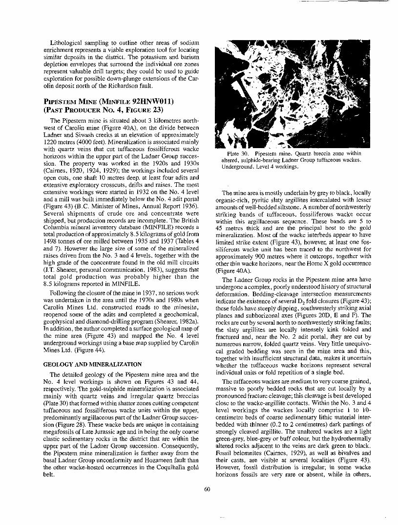
enrichment represents a viable exploration tool for locating Lithological sampling to outline other areas of sodium
similar deposits in the district. The potassium and barium depletion envelopes that surround the individual ore zones represent valuable drill targets; they could be used to guide
o h deposit north of the Richardson fault. exploration for possible down-plunge extensions of the Car-
PIPESTEM MINE (MINFILE 92HNWOll) (PAST PRODUCER NO. 4, FIGURE 23)
The Pipestem mine i s situated about 3 kilometres north- west of Carolin mine (Figure 40A), on the divide between Ladner and Siwash creeks at an elevation of approximately
with quartz veins that cut tuffaceous fossiliferous wacke 1220 metres (4000 feet). Mineralization is associated mainly
horizons within the upper part of the Ladner Group succes-
(Caimes, 1920, 1924, 1929); the workings included several sion. The property was worked in the 1920s and 1930s
extensive exploratory crosscuts, drifts and raises. The most open cuts, one shaft 10 metres deep, at least four adits and
extensive workings were started in 1932 on the No. 4 level and a mill was built immediately below the No. 4 adit portal (Figure 43) (B.C. Minister of Mines, Annual Report 1936). Several shipments of crude ore and concentrate were
Columbia mineral inventory database (MINFILE) records a shipped, but production records are incomplete. The British
total production of approximately 8.5 kilograms of gold from
and 7). However the large size of some of the mineralized 1498 tonnes of ore milled between 1935 and 1937 (Tables 4
raises driven from the No. 3 and 4 levels, together with the high grade of the concentrate found in the old mill circuits (J.T. Shearer, personal communication, 1983), suggests that total gold production was probably higher than the 8.5 kilograms reported in MINFILE.
Following the closure of the mine in 1937, no serious work was undertaken in the area until the 1970s and 1980s when Carolin Mines Ltd. constructed roads to the minesite, reopened some of the adits and completed a geochemical, geophysical and diamond-drilling program (Shearer, 1982a). In addition, the author completed a surface geological map of the mine area (Figure 43) and mapped the No. 4 level underground workings using a base map supplied by Carolin Mines Ltd. (Figure 44).
GEOLOGY AND MINERALIZATION
The detailed geology of the Pipestem mine area and the No. 4 level workings is shown on Figures 43 and 44, respectively. The gold-sulphide mineralization is associated mainly with quartz veins and irregular quartz breccias (Plate 30) that formed within shatter zones cutting competent tuffaceous and fossiliferous wacke units within the upper, predominantly argillaceous part of the Ladner Group succes- sion (Figure 28). These wacke beds are unique in containing
clastic sedimentary rocks in the district that are within the megafossils of Late Jurassic age and in being the only coarse
upper part of the Ladner Group succession. Consequently, the Pipestem mine mineralization is farther away from the basal Ladner Group unconfonnity and Hozameen fault than the other wacke-hosted occurrences in tbe Coquihalla gold belt.
Plate 30. Pipestem mine. Quartz breccia zone within
Underground, Level 4 workings. altered, sulphide-bearing Ladner Group tuffaceous wackes.
The mine area is mostly underlain by grey to black, locally organic-rich, pyritic slaty argillites intercalated with lesser amounts of well-bedded siltstone. A number of northwesterly
within this argillaceous sequence. These bands are 5 to striking bands of tuffaceous, fossiliferous wacke occur
45 metres thick and are the principal host to the gold mineralization. Most of the wacke interbeds appear to have limited strike extent (Figure 43), however, at least one fos- siliferous wacke unit has been traced to the northwest for
other thin wacke horizons, near the Home X gold occurrence approximately 900 metres where it outcrops, together with
(Figure 40A).
undergone a complex, poorly understood history of structural The Ladner Group rocks in the Pipestem mine area have
deformation. Bedding-cleavage intersection measurements
these folds have steeply dipping, southwesterly striking axial indicate the existence of several D, fold closures (Figure 43);
planes and subhorizonal axes (Figures 20D, E and F). The rocks are cut by several north to northwesterly striking faults; the slaty argillites are locally intensely kink folded and fractured and, near the No. 2 adit portal, they are cut by numerous narrow, folded quartz veins. Very little unequivo- cal graded bedding was seen in the mine area and this, together with insufficient structural data, makes it uncertain whether the tuffaceous wacke horizons represent several individual units or fold repetition of a single bed.
massive to poorly bedded rocks that are cut locally by a The tuffaceous wackes are medium to very coarse grained,
pronounced fracture cleavage; this cleavage is best developed close to the wacke-argillite contacts. Within the No. 3 and 4 level workings the wackes locally comprise 1 to 10- centimetre beds of coarse sedimentary lithic material inter- bedded with thinner (0.2 to 2 centimetres) dark partings of
green-grey, blue-grey or buff colour, but the hydrothermally strongly cleaved argillite. The unaltered wackes are a light
altered rocks adjacent to the veins are dark green to black. Fossil belemnites (Caimes, 1929), as well as bivalves and
However, fossil distribution is irregular; in some wacke their casts, are visible at several localities (Figure 43).
horizons fossils are very rare or absent, while in others,

particularly toward the presumed stratigraphic base of the unit, they are densely packed.
genera.lly quartz poor; characteristically they contain The unaltered tuffaceous wackes at Pipestem mine are
numerous broken subangular plagioclase crystals together
feldspar-porphyritic and aphanitic acid volcanic rock. Com- with abundant (up to 35 percent) angular fragments of altered
monly this tuffaceous material is mixed with variable amounts (up to 80 per cent) of broken bivalve shell fragments
clast lithologies include altered greenstone (up to 10 per cent) and rounded grains of recrystallized dolomite. Less common
with lelsser amounts of chert, argillite, feldspar and strained quartz crystals. The lime-rich rocks are commonly cut by
ding and the rock matrix is often replaced by variable veins of secondary carbonate orientated normal to the bed-
amourts of epidote, chlorite and carbonate. The north- western margins of some wacke horizons contain scattered
narrow, irregular, unmineralized quartz veins (Figure 43). barren pyrite cubes up to 1.5 centimetres across and some
and dykes up to 4 metres thick. These include a highly altered The sedimentary rocks are intruded by several narrow sills
hornblende-hearing diabase intrusion outcropping about 60 metres northeast of the No. 3 adit portal, as well as several porphyritic felsic sills (Figures 43 and 44). The latter re- semble the minor felsic intrusions spatially associated with some gold occurrences in the Swash Creek area and are generally leucocratic, moderately altered and carry large phenocrysts of quartz and/or albitic plagioclase. The margins of ona felsic sill, which intrudes wackes approximately 150 metres south-southwest of the No. 3 adit portal, contain thin quartz veins and pyrite, hut no gold. Many of the felsic sills have faulted contacts and are cut by irregular quartz veins; the quartz veins within a faulted felsic sill approx- imately 60 metres northeast of the No. 3 adit portal contain clusters of white scaly aggregates which x-ray diffraction studies indicate to he a mixture of sericite, chlorite and the sodium-rich mica, paragonite (Y.J. Kwong, personal com- munimtion, 1982).
are exposed in the surface trenches on the Pipestem property Auriferous, sulphide-hearing quartz veins and stringers
(Figure 43), but the best mineralization is exposed under- ground in the No. 3 and 4 level workings (Figure 44). Cairnes
gold. In the trenches the black, hydrothermally altered host- (1929) reports the presence of both visible and microscopic
rock wackes are cut by irregular white quartz veins up to 0.5 metre in thickness. These veins have sharp contacts and
are both crosscutting and parallel to the fracture cleavage in
rocks contain variable amounts of coarsely crystalline pyrite the hostrocks. The veins and the heavily chloritized wall-
with some cubic crystals exceeding 1.25 centimetres in size. Arsenopyrite, together with minor sericite and chlorite, occurs sporadically.
els 3 and 4 is preferentially concentrated along either the The gold-bearing quartz-sulphide mineralization on Lev-
faulted contacts between the wackes and argillites, or along fracture-related shatter zones in the main wacke units (Fig- ure 44). Discrete hut fragmented quartz veins up to 0.4 metre wide and quartz stringer swarms and quartz breccia zones up to 1.5 metres in width are present (Plate 30). These are discontinuous along strike: some quartz breccia systems pinch and swell and others are cut by late faulting.
The quartz in the veins, stringers and breccias is white and varies from massive to vuggy; the latter variety contains small cavities lined with fine-grained quartz crystals. Locally the veins also contain clots of pale, altered feldspar and traces of sericite, carbonate and chlorite. The breccia zones consist of sharply angular, silicified and sulphide-bearing fragments of chloritized Ladner Group rocks enclosed within a massive to weakly vuggy matrix of white quartz. Clasts are mostly matrix supported and are generally 0.5 to 5 centimetres in diameter, but locally exceed 15 centimetres across.
The irregular, impersistent quartz stringer zones are gener- ally barren. However, some of the thicker quartz veins and breccia zones are surrounded by wallrock alteration envel- opes that vary from a few millimetres up to 0.4 metre wide and which carry erratic gold values. This alteration, which affects both the wallrock and the sedimentary clasts in the
to 40 per cent disseminated, coarsely crystalline pyrite with breccias, is characteristically dark coloured and contains up
sporadic arsenopyrite and traces of pyrrhotite. Sulphides are generally more abundant in the alteration envelopes, and poorly developed in the quartz veins. Shearer (19%) reports that drilling on the property intersected some chloritic and sericitic wallrock alteration, together with albite-calcite veinlets.
GEOCHEMISTRY OF THE MINERALIZATION AT PIPESTEM MINE
Trace element analyses from eight sulphide-hearing sam- ples collected from both the trenches and the No. 3 and 4 level underground workings are shown in Appendix 15. They
REPORTED ANNUAL PRODUCTION FROM THE PIPESTEM MINE* TABLE 7.
Year Tonnes milled Gold production (9)
Silver production
1935 1936 1937
271 953 318
2 115
5 070 1 215
218 746 I87
Totals 1 498 8 460 1 151
* (Data taken from MINFILE, 092HNWOI 1 . )
61

include samples of quartz vein, quartz breccia and pyritic wallrock alteration. The highest gold values occur in the sulphide-rich wallrock alteration envelopes rather than in the
example, sample PS 7) contain economic gold values. quartz veins, but not all the altered wallrock samples (for
There is a positive correlation between gold and arsenic, and the mineralization is associated with the sporadic trace enrichment of mercury. The gold-silver ratio of the auriferous samples varies between 1:l and IO:]; gold-silver ratios determined on the meagre production data (Table 7) average 7: 1. Atomic absorption spectroscopy indicates that two of the most auriferous samples (PS 3 and 5 ) are anomalous in tungsten, but no quantitative values for this element are available.
CONCLUSIONS ON PIPESTEM MINE
The highest gold values at Pipestem mine are concentrated in narrow, sulphide-rich wallrock alteration envelopes that surround poorly mineralized to barren quartz veins, stringers and breccia zones. The mineralization is hosted by fos- siliferous and tuffaceous wackes of Late Jurassic age, that are interbedded with a predominantly argillite sequence in the upper portion of the Ladner Group succession.
comprises abundant coarse pyrite with variable amounts of The sulphide mineralogy is comparatively simple and
arsenopyrite and some minor pyrrhotite. Trace amounts of chalcopyrite are very rare and there are no reports of sphalerite in the ore. The quartz veins are both massive and vuggy, but unlike those at the Emancipation mine, the carbonate content is very low. Gold and arsenic have a positive sympathetic relationship, and the mineralization is associated with the trace enrichment of mercury and possibly tungsten.
Interpretation of the geology and morphology of the miner-
structure of the mine area which remains poorly understood. alized zones at Pipestem mine is inhibited by the complex
Clarification of the structural history is a prerequisite for successful exploration as the mineralization probably follows shatter zones developed where fault planes intersect folded wacke horizons. The controlling folds, like those at Carolin mine, are probably D, structures; at Pipestem mine they are upright, with southwesterly striking axial planes and sub- horizontal axes (Figure 20D, E and F). However, the precise orientation of the controlling fractures and the plunge of the ore shoots are unknown. Unfortunately, the geology mapped on No. 4 level (Figure 44) cannot be positively correlated
No. 4 level penetrate a thick, mineralized wacke unit that with the surface (Figure 43). The western extensions of the
thick unit nor the fold structure are recognized on surface. may occupy a major fold hinge (Figure 441, but neither the
WARD MINE (MINFILE 92HNW015) (PAST PRODUCER No. 5, FIGURE 23)
4.2 kilograms of gold from an unknown quantity of ore Total production from the Ward mine is reported as
milled (Table 4). There is little detailed information available on the geology, production, precise location or full extent of the mine workings. The following synthesis is based on various British Columbia Minister of Mines Annual Reports
(MMAR), a brief report by Bateman (19 11) and observations made in the course of this project.
The Ward claims (Ward and No. 2 Ward) were located on
confluence with the middle and north forks (MMAR, 1917, the east side of the south fork of Siwash Creek, close to its
page F227). The Roddick and Emigrant claims were situated west and south of the Ward property respectively (Figure 23). In 19 11, a six-stamp mill was operating on the Ward property (MMAR, 1917) and Bateman (1911) reported work being conducted on an open cut and three adits, one of which was approximately 90 metres in length. The ore was carried from the open cut to the mill in I-ton cars by a gravity-drive cableway 150 metres long. The remains of a mill and several
Forks area. small, collapsed adit portals are still discernible in the Siwash
The Ward claims are largely underlain by poorly to moder- ately bedded, dark, pyritic slaty argillites of the Ladner Group. These are intercalated with very rare, thin beds of wacke and siltstone which locally exhibit well-developed graded bedding. In the Siwash Forks area the Ladner Group rocks are deformed by upright D, folds, and are intruded by numerous light-coloured felsic sills and dykes that are mostly
width. Some of these intrusives are strongly altered and are 1 to 5 metres wide, although some exceed 150 metres in
soft and deeply weathered. The sills and dykes include both equigranular and feldspar porphyry varieties; gold is spa- tially associated with the latter which Bateman described as
resemble the felsic sills at the Pipestem mine approximately “quartz-syenite-porphyry”. These porphyritic intrusions
claims have irregular, chilled margins and narrow aureoles of 6 kilometres to the south. Many of the felsic sills on the Ward
argillites. Elsewhere the sills are fault bounded and the weak thermal alteration are developed in the adjacent
0.6 metre wide. Many sills are also cut by irregular quartz contacts marked by rust-stained veins of white quartz up to
stringers, quartz-filled tension gashes, or more regular, inter- secting sets of quartz veins generally up to 5 centimetres wide. These veins contain small vuggy cavities lined with quartz crystals and sparse amounts of disseminated pyrite. Bateman reports that fine gold occurs both in the quartz and the porphyry intrusions and is generally coated with a film of iron oxide; globules of mercury were also noted in some of the pyritic gangue. However, it should be noted that similar early reports of mercury occurring in the Aurum mine mineralization were not substantiated by later analyses (Cairnes, 1929).
GOLD OCCURRENCES IN THE COQUIHALLA GOLD BELT
Coquihalla gold belt contains at least 25 gold occurrences all In addition to the five past-producing mines, the
spatially associated with the Hozameen fault system (Figure 23). The following synopsis of each occurrence is based either on early publications, such as those by Cairnes, (1920, 1924, 1929), theBritishCoIumbiaMinisterofMinesAnnua1 Reports (MMAR), unpublished assessment reports and the
on observations made during this survey. However, pre- British Columbia mineral inventory database (MINFILE), or
viously published data concerning the claim names, geology, mineralization and location of some Occurrences are vague or contradictory.
62

BROKEN HILL (MINFILE 92HSW035) slickensided surfaces of talc or talcose sementinite. hut is
Spider Peak Formation. The largest vein is hosted by north- northeast-striking slaty argillites and is up to 3 metres wide over a strike length of 60 metres. It is irregularly mineralized with arsenopyrite, some pyrite and traces of galena. A single samplo collected from across a wider, but sulphide-poor section of the vein contained no gold or silver (Cairnes, 1924).
The argillites are intruded by two strongly altered, calcite- rich andesite dykes that are 2.5 and 4.5 metres wide respec- tively and about 50 metres apart. The wider dyke is in contact with the quartz vein and Caimes (1924) speculated that the dykes are genetically related to the mineralization.
Soum FORK GROUP (OCCURRENCE No. 7, FIGERE 23)
property and covers part of the upper basin of Fifteen Mile This group of claims was located west of the Aurum
Creek; the principal workings are along the south branch of the south fork of Laduer Creek, at elevations of 975 and 1000 metre:$ (3200 and 3300 feet). The property lies within the Coquihalla serpentine belt and is mostly underlain by serpen- tinite which is cut by irregular lenses and dykes of altered diorite up to 6 metres wide. The principal workings were two adits with portals 100 metres apart and comprising 170
talc and carbonate-bearing shear, 15 to 24 metres wide, metres of drifts and crosscuts. These workings followed a
which reportedly carried sporadic hut conspicuous amounts of fres gold. However, a sample of talcose rock collected from .the lower adit contained no economic mineralization (Cairnes, 1929).
FIFTEEN MILE GROUP (OCCURRENCE No. 8, FIGLIRE 23)
basin of Fifteen Mile Creek which is mostly underlain by This group of nine claims was located within the drainage
ultramafic rocks of the Coquihalla serpentine belt, close to
northwesterly striking talcose shears was outlined (Caimes, their contact with the Hozameen Group. A series of narrow,
1929). The uppermost shear averages 15 centimetres in width and contains crushed talcose gouge at the contact between a diorite dyke and sheared serpentinite. No significant sul- phide mineralization was noted by Caimes, although occa- sional free gold was reported.
The next underlying shear, which was known as the “main seam” is up to 15 metres wide, although gold values are reportedly confined to a 60-centimetre thickness of talcose rock. The mineralized zone lies within altered serpentinites close to their contact with a decomposed diorite dyke 60 metres wide. The gold occurs mainly as polished films on
SNOWSTORM (PITTSBURG) (MINFILE 92HNW006) (OCCURRENCE No. 9, FIGURE 23)
original Idaho claims, and was located on the northwestern The Snowstorm-Pittsburg group of claims adjoined the
slope of the west fork of Ladner Creek, covering the contact between the Spider Peak Formation and the Ladner Group. The following description is largely summarized from Cairues (1920,1924). Most of the early work was done on the Pittshurg claim, approximately 90 metres above Ladner Creek. Work completed in the early 1920s included driving a
northwesterly striking mineralized zone along the fractured 12-metre adit and making a series of open cuts to trace a
contact between greenstones of the Spider Peak Formation
driven along one of three mineralized fracture zones within and Ladner Group slaty sedimentary rocks. The adit was
the greenstones, approximately 60 metres southwest of the greenstone-slate contact. This “Contact vein” strikes north-
Idaho claims. It mostly follows the greenstone-slate contact, west, dips steeply northeast and was traced onto the adjoining
but at its highest elevation it lies entirely within slaty sedi- mentary rocks of the Ladner Group. The width of the Contact vein varies considerably, as does the amount of vein quartz present. Near the adit it averages 4 to 6 metres wide and contains abundant quartz stringers similar in composition to
contains solid vein quartz over 3 metres wide. Cairnes those at the Emancipation mine. In other places the zone
reports obtaining pannable gold from the vein, and notes the sporadic presence of pyrite, pyrrhotite and arsenopyrite.
second mineralized structure, the “West vein”, which is an Close to the adit portal the Contact vein is intersected by a
elongate, curvilinear shatter zone within the greenstones of the Spider Peak Formation. In places it is represented by a single quartz vein “several feet in width” while elsewhere it is marked by a less well defined sulphide-rich, quartz-poor zone.
A third mineralized zone, the “North vein” also intersects
contains large amounts of vein quartz and the wallrock slates the Contact vein but is hosted entirely by the Ladner slates. It
are silicified and contain pyrite and arsenopyrite.
In summary, the Snowstorm-Pittshurg property covers three sporadically mineralized fracture zones whose develop- ment was controlled by brittle faulting along the contact between the more competent Spider Peak greenstones and
vein quartz in the fracture zones, together with the wallrock less competent Ladner slates. The sporadic development of
alteration, and the tendency ofthe zones to intersect and pass horizontally and vertically from the greenstone into the slates, is strikingly similar to the vein systems at the Eman- cipation mine.
63

MONTANA (MINFILE 92HNWOOS) (OCCUR- RENCE NO. 10, FIGURE 23)
This property consisted of six claims and one fraction that
west of Pipestem mine. Cairnes (1924, 1929) reported that an extended northwest from the Idaho claims, toward the area
open cut exposed a number of 5-centimetre-wide quartz veins cutting greenstones of the Spider Peak Formation, about 20 metres southwest of their contact with Ladner Group slates. The veins yielded rich specimens of free gold and the wallrocks contain pyrite. The nearby slates were also cut by a calcareous “lead”, 1 metre thick, containing pyrite and pyrrhotite.
rence has previously been incorrectly grouped with the It should he noted that in MINFILE, the Montana occur-
Georgia 2 occurrence. However, the latter is situated farther north on the Spider Peak group of claims (Figure IO in Cairnes, 1929).
RUSH OF THE BULL (MINFILE 92HNW009) (OCCURRENCE No. 11, FIGURE 23)
This occurrence lies on the Rush of the Bull Fraction which was located north of both the Rush of the Bull No. 1 and Montana claims (Cairnes, 1920). It is situated at an elevation of approximately 1370 metres (4500 feet) close to
Pipestem mine. The Ladner Group slates are cut by two the old Pipestem trail that connected the Idaho claims to
quartz veins averaging 10 centimetres in thickness; both the veins and the adjacent wallrocks are mineralized with coarse
arsenopyrite and some free gold. Caimes (1924) notes that the slates near the showing are intruded by several felsic feldspar porphyry dykes and sills similar to those present at Pipestem mine and the Siwash Creek-Ward mine area.
MCMASTER ZONE (OCCURRENCE No. 12, FIGURE 23)
gold-sulphide-albite-quartz-carbonate mineralization, iden- The McMaster zone is characterized by wacke-hosted,
tical to that at the Carolin mine (Plates 3 1 and 32). It is located approximately 2.5 kilometres southeast of Spider Peak and 2.0 kilometres northwest of Carolin mine. It was discovered in 1975 (Griffith, 1978; Shearer, 1982a) by Precambrian ShieldResourcesLimitedfollowingcompletionofaprogram of geochemical soil sampling; subsequent work included trenching and drilling seven shallow holes. Carolin Mines Ltd. gained control of the property in 1976.
geologically mapped by pace and compass traverses (Fig- During the present survey, part of the property was
ure 36) and some sulphide-bearing outcrops were sampled and assayed (Appendix 16).
GEOLOGY AND MINERALIZATION
The geology of the McMaster zone is shown on Figure 36. The mineralization, like that at Carolin mine, is hosted by folded and faulted, coarse clastic sedimentary rocks belong- ing to the lower part of the Ladner Group succession, less than 100 metres from its unconformable contact with the
fl:::l%EkED
SILTSTONES
WACKES; WI -LITHIC WACKES
WACKESWITH CONGLOMERATE BEDS - UNCONFORMIW
SPIDER PEAK FORMATION UNDIFFERENTIATED
CHLORITIC. SCHISTOSEGREENSTONE a BRECCIATEDGREENSTONE
/vm/ MASSIVE GREENSTONE ? GABBRO
FOLIATEDGREENSTONE
COOUIHALLA SERPENnNE BELT UNDlFFERENnATEO
BEDDING;~PSKNOWN. OVERTURNED,
CLEA’VAGE ..................................
UNKNOWN . . . . . . . . . . . . . . . . . . . . . . . . +-
MASSIVEOUTCROPS. . . . . . . . . . . . . . . . . . . . . . . . . . . . + OUTCROP AREA. . . . . . . . . . . . . . . . . . . . . . . . . . . . . .;::: sULPHIOES ? QUARTZVEINS . . . . . . . . . . . . . . . . . . . . . .??& FAULT . . . . . . . . . . . . . . . . . . . . . . . . . . . . . . . -- CONTAU
SAMPLE NO.. . . . . . . . . . . . . . . . . . . . . . . . . . . . . GR 220
Figure 36. Geology of the McMaster Zone occurrence.
64

Spider Peak Formation. To the northeast the Ladner Group is
Peak Formation and ultramafic rocks of the Coquihalla in fault contact with greenstones and gabbros of the Spider
serpentine belt. These fault contacts are not exposed but underlie a valley that trends northwestward to McMaster Pond (Figure 40A). Scattered angular boulders of fuchsite- bearing quartz-carbonate rock (listwanite), up to 3 metres long, were mapped in this valley, northwest of the showings
contact between the Ladner Group and Spider Peak Forma- (Figure 36; Plate 8). To the southwest, the unconformable
tion is locally faulted and sheared. The Spider Peak rocks include both massive and strongly cleaved, schistose green- stones together with some thin beds of volcanic sandstone.
zone are predominantly an interbedded succession of locally The Ladner Group rocks in the vicinity of the McMaster
graded siltstones, wackes and coarse volcanic-lithic wackes with some thin discontinuous beds of argillite, volcanic sandstone and conglomerate (Plate 14). The conglomerates contain deformedpebbles and cobbles up to 25 centimetres in length within a fine-grained silty matrix. Clast lithologies
acid volcanics, quartzites and lesser amounts of coarse- include volcanic greenstones, altered gabbros, pale-coloured
grained granitic rocks. The siltstones and bedded wackes contain slump and flame structures that suggest deposition by
westerly directed paleocurrents. Many of the metasediments
cleavage intersections indicate that they occupy the inverted, are overturned and young northeastwards; the bedding-S,
steeply dipping southwestern limb of a D2 antiform that verges to the northeast.
Thin, elongate units of brecciated, altered and strongly cleaved greenstone occur within the Ladner Group. These are believed to represent fault-bounded slices of Spider Peak Formation (Figure 36), similar to those outcropping close to the Carolin deposit.
ritized, and form quartz-veined outcrops that weather to a The mineralized wackes are strongly albitized and chlo-
black and rust-stained colour. The alteration and gangue
hand specimen and thin section (Plates 31 and 32). Miner- mineralogy are identical to that seen at Carolin mine, both in
generally comprise pyrrhotite, pyrite and arsenopyrite, alized outcrops contain up to 10 per cent sulphides which
together with both pervasive albite and albite veins as well as at least two generations of irregular, randomly orientated quartz veins. Late quartz-carhonate veins and carbonate disseminations are also present.
GEOCHEMISTRY OF THE McMASTER ZONE MINERALIZATION
collected from sulphide-bearing quartz-veined outcrops of The analytical results obtained from two grab samples
the McMaster zone are shown in Appendix 16 (for sample location see Figure 36). The higher gold values are associated with enrichment in arsenic and depletion in barium. There is no evidence of anomalous mercury associated with the mineralization.
CONCLUSIONS ON THE McMASTER ZONE
The mineralization in the McMaster zone is similar in its mineralogy, alteration features, hostrock lithologies and overall structural and stratigraphic setting to that at Carolin mine. Consequently, future exploration on the property should be directed toward orebodies of the Carolin type that have a saddle reef morphology and are surrounded by halos of specific geochemical enrichment and depletion.
Exploration should include detailed structural mapping to outline D, fold hinges in the Ladner Group, together with
antimony, arsenic and gold enrichment. Drill core should be lithogeochemical sampling to delineate areas of sodium,
routinely analysed to detect possible ore-related zones of potassium and barium depletion.
GOLDEN CACHE (MINFILE 92HNW048) (OCCURRENCE No. 13, FIGURE 23)
This occurrence outcrops on the Golden Cache No. 1 claim, which was the southernmost of three claims forming the Gem group (Cairnes, 1920, 1924). The claims adjoined the Rush of the Bull Fraction to the north, at the head of the middle fork of Ladner Creek, and largely followed the Ladner GrouplSpider Peak Formation contact. The occur-
Plates 31 and 32. McMaster Zone. Photomicrographs rence includes six narrow west-northwesterly striking, (PPL, Plate 31; X Nicols, Plate 32) showing fine-grained, laycred sulphide-albite-quartz-gold-bearing mineralized
steeply dipping quartz veins that cut an unidentified host-
wackes crosscut by a vein of fresh, coarser grained albite. rock. Cairnes reports the veins are sparingly mineralized
Sample GR 220 (for location see Figure 36 ). with pyrite and arsenopyrite, and that they carry low gold values.
65

MURPHY (OCCURRENCE No. 14, FIGURE 23) STAR (MINFILE 92HNW014) The Murphy gold occurrence is exposed at an elevation of (OCCURRENCE No. 16, 23)
about 1460 metres in a roadcut approximately 400 metres north-northwest of McMaster Pond (Figure 40A). It was prised three claims (Star, Ladner No. 1 and Ladner No. 2)
This occurrence outcrops on the Star group, which com-
discovered in 1982 by prospector D. Murphy, while inves- located immediately north of the Pipestem mine (MMAR, tigating a gold geochemical in soils, outlined by 1933). Four trenches exposed anorthwest-striking shear zone carolin ~i~~~ Ltd. The mineralization consists of fine free 2 metres wide over a reported strike length of 200 metres. gold associated with sparse amounts of pyrite and arseno- The shear contains 1.2 metres of quartz and 80 centimetres of
pyrite in a quartz vein between 5 and 25 centimetres wide. pyritized Ladner Group slate. An assay of 1.7 grams per tonne gold (0.05 ounce per ton) was recorded and locally the
The vein can be traced discontinuously for 20 metres within soil contained gold, altered greenstones of the SDider Peak Formation, within - 2 metres of the steeply dipping East Hozameen fault which
pentinites of the Coquihalla serpentine belt. Approximately separates the greenstones from strongly sheared talcose ser-
100 metres to the southeast the fault contains a thin (5 to
(listwanite). The auriferous quartz vein strikes subparallel to 15 metres) slice of fuchsite-bearing quartz-carhonate rock
the East Hozameen fault hut dips very gently northeastwards (between 5 and 15”) into the hillside. The dark brick-red soil over the Occurrence contains appreciable quantities of pann- able gold.
The vein pinches and swells along strike and comprises white quartz containing small vugs lined with clear quartz crystals; the sulphides in the vein are visually estimated to be less than 2 per cent by volume. Gold is most commonly seen as a fine coating on chocolate-brown alteration products comprising a mixture of goethite, hematite and lepidocrocite with some remnant pyrite. Elsewhere, fine gold is associated
free in the quartz. The gold and sulphides occur at both the with both pyrite and arsenopyrite and, in rare instances, it is
vein margins and centres, but there is no noticeable wallrock alteration. Trace element analyses on a sample of sulphide- bearing vein quartz are shown in Appendix 17. Despite the anomalous arsenic content, the sample shows no enrichment in either gold, silver, mercury or antimony.
GEM (MINFILE 92HNW010) (OCCURRENCE No. 15, FIGURE 23)
three claims forming the Gem group where a decomposed The Gem gold occurrence outcrops on the northernmost of
quartz vein, 2 metres wide and containing fragments of silicified country rock, was exposed in three trenches. Pyrite
rocks, particularly the hangingwall which is a west- and arsenopyrite are present in both the vein and the wall-
northwesterly striking, steeply dipping felsic sill. The quartz vein strikes toward the Pipestem mine which lies farther north on adjoining claims. No mention of the country rocks around the Gem occurrence is made by Cairnes (1920,1924), however, the presence .of the felsic sill and the location of the occurrence in relation to the Pipestem mine, suggest that the Gem vein is hosted by the Ladner Group, rather than the Spider Peak Formation. Caimes reports that the most north- erly of the three surface showings is overlain by red soil that contains pannahle gold. This appears similar to the brick-red, gold-bearing soil present at the Murphy occurrence.
HOME X (MINFILE 92HNW013) (OCCURRENCE No. 17, FIGURE 23)
located north of the Pipestem property. Several trenches in The Home X property originally comprised eight claims
the Ladner slates exposed numerous quartz veins up to 15 centimetres wide that contain pyrite, arsenopyrite and low gold values (MMAR, 1933).
Some old workings on the Home X ground close to the Carolin-Pipestem mines road, about 600 metres northwest of Pipestem mine, were examined during this survey. There appeared to he one or possibly two collapsed adit portals, with a small dump containing large fragments of quartz- veined black slaty argillite. Black, poor to moderately bed- ded Ladner slaty argillites, cut by irregular quartz veins up to
The veins contain sparse amounts of pyrite and traces of 10 centimetres wide, are exposed close to these workings.
arsenopyrite concentrated in fractures that both cross the quartz veins and follow the vein contacts. A sample of quartz-,veined, sulphide-hearing argillite from the dump was assayed but contained no enrichment in gold, arsenic, anti- mony or mercury.
The Ladner argillites hosting Home X mineralization lie adjacent to several thin, fossiliferous tuff and wacke horizons that are probable northwesterly strike extensions of the units hosting the Pipestem mine veins.
GEORGIA No. 2 AND NORM (MINFILE 92HNW008 AND 056) (OCCURRENCE No. 18, FIGURE 23)
uncertain; early published details are not specific and The exact location of the Georgia No. 2 occurrence is
attempts by IT. Shearer (personal communication, 1982) and the author to locate the occurrence were unsuccessful. MINFILE incorrectly lists the Georgia No. 2 within the Montana group of claims, when in fact it formed part of Spider Peak claim group (Caimes, 1929). Both these claim groups are located in the Spider Peak area and originally comprised four claims and two small fractions that extended northwesterly along the divide between Hillsbar (now Qualark) Creek and the north fork of Siwash Creek. The four claims covered ultramafic rocks and listwanites of the Coquihalla serpentine belt, and greenstones of the Spider Peak Formation. The occurrence is reported to lie close to the southwestern boundary of the Georgia No. 2 claim at an elevation of 1310 metres (4300 feet) (Caimes, 1929). A trench exposed a mineralized, easterly striking and northerly
66

dipping fault cutting Spider Peak greenstones. This fault contains sparsely disseminated sulphides, but there is uncer- tainty concerning the gold values obtained on the property. Cairnej (1929) reports, that 2.5 tons of ore shipped to the Tacoma smelter assayed $9.00 in gold, while MMAR (1925) mentions that 37 ounces ( I 151 grams) of gold was won from
However, Cairnes also notes that this small operation proba- approximately 2 tons of presumably hand-sorted ore.
bly removed most of the ore. The Norm claims lie close to the Georgia No. 2 occurrence
on the southwestern slopes of Spider Peak. Unpublished reports by Cochrane (1975), Montgomery and Symonds (1976) and Dion and Cochrane (1978) indicate that the large fault slice of quartz-veined listwanite exposed approximately 500 metres southwest of Spider Peak is associated with soils containing pannable gold, and geochemical soil anomalies up to r3.3 ppm gold. However only low gold values were obtained from rock-chip samples.
EMIGRANT (MINFILE 92HNW005) (OCCURRENCE No. 19, FIGURE 23)
fraction was located south of the Ward claims along the south The Emigrant group, which consisted of six claims and one
fork of Siwash Creek (MMAR, 1917). The geology and style of mineralization are similar to that reported at the Ward mine. The area is largely underlain by Laduer argillites and the go1.d mineralization is associated with felsic porphyry sills and dykes, and occurs mostly in quartz-filled tension veins that either cut the porphyry or occupy the faulted dyke margins.
At le.ast three adits were driven on the west side of the south fork o:F Siwash Creek, at an elevation of approximately 610me:tres(2000feet)(MMAR, 1917). TheupperNo. 1 adit was driven in a northwesterly direction, and at 21 metres intersected a quartz vein 35 centimetres wide that reportedly carried gold. The No. 2 adit, driven parallel to the No. 1 and 27 metres below it, intersected the footwall of the same vein at a diistance of 125 metres from the portal but had to be abando’ned due to flooding. No. 3 adit was then driven west from t17e No. 2 portal and cut the vein at a distance of 131 metres. The vein on the No. 2 level is approximately 6 metres wide, dips 25” northwest and contains white quartz which is ribboned with bands of slate. Assays on five samples taken across a vein 3.5 metres wide ranged from 2.7 to 16.4 grams per tonne gold (MMAR, 1917).
RODD’ICK (MINFILE 92HNW004) (OCCIURRENCE No. 20, FIGURE 23)
The Roddick occurrence outcrops on Crown-granted Lot 78 situated approximately 500 metres south of the confluence of the north and south forks of Siwash Creek (MMAR, 1917). It lies between the Emigrant and Ward properties, adjacent to a small northeasterly flowing tribu- tary of the south fork of Siwash Creek. This tributary was originally called Roddick Creek, however, on the current
name “Roddick Creek” is assigned to another northeast- 150 000 topographic map (92W1 I ) it is unnamed, and the
flowing tributary approximately 1 kilometre to the southeast.
are similar to that on the Ward and Emigrant properties. The geology and gold mineralization on the Roddick claim
Ladner Group argillites, interhedded with thin wacke hori- zons, are intruded by feldspar porphyry dykes and sills that are spatially related to the gold mineralization. Bateman (1911) reports that a porphyry dyke 7.5 metres wide is associated with narrow lenses and stringers of quartz that cut both the dyke and the slate wallrocks. The quartz veins reportedly carry iron oxides and yielded some rich specimens of free gold.
GOLD QUEEN (MINFILE 92HNW016) AND DOLLY VARDEN (OCCURRENCE No. 21, FIGURE 23)
Queen occurrence, except that it is situated close to the Few details are known concerning the location of the Gold
Confluence of the middle and south forks of Siwash Creek. By 1901, approximately 150 metres of tunnelling and uuder- ground crosscuts had been driven on the property (MMAR,
containing some gold values (up to $8.00 per ton). The 1901, 1903). These reportedly cut sulphide mineralization
geology of the property is similar to that at the Emigrant and Ward, and the gold and sulphides are probably hosted in quartz stringers associated with felsic porphyry intrusions.
It is uncertain whether the Gold Queen and Dolly Varden are the same occurrence staked under different names, or
The Dolly Varden was staked in 1911 (Bateman, 1911) and whether they represent two distinct but adjacent properties.
was located between the middle and north forks of Siwash Creek, at an elevation of 520 metres. Development work included a number of trenches along a 190-metre-long porph- yry dyke that intrudes the Ladner Group. One contact of the dyke is marked by a quartz vein 30 to 60 centimetres wide. Narrow quartz stringers splaying from the vein cut both the porphyry and the adjacent Ladner slaty argillites. Pyrite, chalcopyrite and trace galena are reported in the vein
pannable gold (Bateman, 191 I) . stringers and the porphyry, and the overlying soils contain
MARVEL (MINFILE 92HNW019) (OCCURRENCE No. 22, FIGURE 23)
details on its geology are not recorded. MINFILE locates the The precise location of this occurrence is uncertain and
property on the east side of the north fork of Siwash Creek. This area is underlain by Laduer argillites intruded by felsic porphyry sills; the mineralization on the Marvel property is probably similar to that at the Ward mine. MMAR (1906) records the installation of a six-stamp Merrill mill on the Marvel ground and the driving of a tunnel into the hillside, with encouraging results.
SPUZ G (MINFILE 92HNW053) AND RODD A (OCCURRENCE No. 23, FIGURE 23)
The Spuz group of claims were staked in October 1975 for Longbar Minerals Ltd. and extended along the Hozameen fault from the Hidden Creek area, southwards toward Siwash Creek. The Rodd A claims adjoined the Spuz group to the southwest and lay north of the confluence of the north and
61

south forks of Siwash Creek. Between 1976 and 1981, when excitement over the discovery of the Carolin mine deposit was at its peak, considerable exploration work was done on the claims on behalf of Longbar Minerals Ltd. and Aquarius Resources Ltd. (Cochrane 1976, 1979; Cocbrane er al., 1978; Cardinal, 1982). This work included geological map- ping, soil sampling, trenching and some diamond drilling. Some new gold showings were found during the coune of the work including the various Spuz and Rodd A occurrences and the Monument vein. Many of these occurrences, like those farther south on the Ward, Emigrant and Roddick properties,
porphyry dykes and sills that intrude the Ladner Group. are associated with strongly altered, felsic to intermediate
The Spuz GRodd A occurrence is situated on the west side of the north fork of Siwash Creek, approximately 2 kilo- metres north-northwest of its confluence with the south fork (for precise location see Figure 43C in Cochrane et al., 1978.) The area is underlain by Ladner Group slaty argillites that are intruded by numerous sills of felsic porphyry. lsvo trenches, cut 60 metres apart to investigate a gold geochemi- cal anomaly in soils, exposed two moderately foliated and silicified sills. Pannable gold was obtained from crushed samples taken from the sills and from narrow, irregular quartz veinlets that cut the adjacent slates; these veinlets also contain scheelite. A thin fault slice of sheared fuchsite- bearing carbonate rock was also exposed in one trench (Cochrane er al . , 1978).
A minor unnamed gold-scheelite occurrence is exposed in a switchback section of drillroad approximately 400 metres south-southeast of the Spuz GIRodd A occurrence (Fig- ure 43D, Cochrane er al., 1978). A soil geochemical anom- aly in gold is underlain by two westerly dipping, north- northwesterly striking sills, 2.5 metres wide, separated from each other by 1 metre of sheared Ladner slate. The highly fractured and altered sills are medium grained, and probably of granodiorite composition (Cochrane ef al., 1978). The hangingwall argillites are cut by an irregular network of quartz veins; pannable gold was obtained from the altered sills and some narrow fractures contain quartz and scheelite.
Another gold soil anomaly lies approximately 900 metres south of the Spuz GiRodd A occurrence, but no visible gold is reported (Cardinal, 1982). The Ladner argillites are intruded by at least one, and possibly two, flat-lying, strongly fractured and altered felsic sills that include some mafic phases; locally these rocks contain abundant iron carbonate. The contact of one sill is marked by a quartz vein, and the intrusions are locally cut by numerous quartz-filled tension veinlets. These veinlets contain both massive and vuggy quartz but generally carry no sulphides. The veins vary from highly irregular to reticulate.
UNNAMED GOLD OCCURRENCE (OCCURRENCE No. 24. FIGURE 23)
carbonate rock (listwanite) 25 metres thick and 500 metres long. Three closely spaced fractures splay out from the nearby Hozameen fault system and the strongly sheared slates adjacent to the listwanites are weakly talcose and contain disseminated sulphides. Gold was panned from the fuchsite-bearing carbonate rocks (Cochrane er al., 1978) and whole-rock and trace element analyses on two fuchsite- bearing grab samples (Appendices 5A and 5B) indicate they are noticeably enriched in magnesium (due to the abundance of magnesite) and arsenic.
MONUMENT (MINFILE 92HNW054) (OCCURRENCE No. 25, FIGURE 23)
crops out about 3 kilometres southeast of Stout, close to The gold and scheelite-hearing Monument quartz vein
Bigjon Lake5 (Figure 41B). It lies approximately 175 metres east of the Hozameen fault and is hosted by Laduer Group slaty argillites interbedded with thin horizons of tuffaceous wacke and siltstone. In 1977, Longbar Minerals Ltd. con- ducted a mapping and exploratory drilling program and a total of 12 holes were drilled on the Monument vein (Cochrane et al. , 1978). The geology of the vein is shown on Figure 37, and the following description is based on the report by A.L. Littlejohn (Cochrane et a l . , 1978), together with observations by the author.
The steeply dipping Monument vein trends northerly,
meen fault, and varies from 0.3 to 3 metres wide. It generally subparallel to both the Ladner Group bedding and the Hoza-
has sharp contacts with the black argillitic and siltstone hostrocks and mainly comprises massive white quartz that locally contains small rounded to elongate vuggy cavities lined with tiny crystals of clear quartz. The elongate vugs are orientated parallel to the vein contacts and reach 2.5 cen- timetres in length and 0.5 centimetre in width. The quartz vein is strongly fractured in places, and contains minor amounts of altered pink feldspar and carbonate. It also locally
try rock up to 15 centimetres in diameter and, in its southern includes angular xenoliths of brecciated and silicified coun-
portion, encloses an elongate sliver of silicified argillite between 10 and 30 centimetres thick. A I-metre-wide, dark- coloured zone of weak silicification is locally present in the argillites and siltstones immediately adjacent to the vein.
The Monument vein has a stike length of 400 metres, but has been separated into four segments by a set of northerly trending dextral crossfaults (Figure 37) that are probably related to the nearby Hozameen fault system. Some of the slaty argillite wallrock, particularly immediately west of the vein, contains northerly trending silicified shear zones that carry minor amounts of sulphides. Strongly altered, narrow felsic sills, similar to those elsewhere on the Spuz claims, are also found in close association with the quartz vein (Figure 37). These sills, like the Monument vein, predate the eDisode ofdextral faulting. Cochraneeral. (1978) soeculated
An unnamed gold occurrence is located close to the
A occurrence (Cochrane et al., 1978; Cochrane, 1979). A Yale township and 500 metres northwest of the Spuz G/Rodd
gold geochemical anomaly in the soil overlies altered Ladner argillites and part of a fault slice of fuchsite-bearing quartz- Informal name used by Cardinal (1982).
that the vein and the nearby felsic sills are geneti'cally and temporally related, particularly as the sills are geochemically
sill, east of the vein (Figure 37), assayed 0.1 gram per tonne gold (Cochrane er al. , 1978).
Hozameen approximately kilometres northeast Of anomalons in gold, One grab sample from the
68

(Geotyi~dl mapping largely byA.L. Littlejohn) -
(adapted after Cochrane et al . , 1978, and from observations Figure 37. Geology of the Monument quartz vein
of the author).
Minor mineralization is found in both the nearby, thin tuffaceous wacke horizons and the subparallel silicified shear zones in the argillites. The silicified zones contain fine- grained pyrite and traces of chalcopyrite; crushed rock sam- ples yilelded traces of panable gold but the assay values were low. The thin tuffaceous wacke horizons contain pyrite, pyrrhotite and minor chalcopyrite.
gold, particularly near the vein margins and close to the Surface exposures of the Monument vein contain visible
major offsetting fault in the central portion of the vein. Gold
occurs both as small nuggets 0.5 to 2.0 millimetres in diameter within vugs or enclosed in the quartz, and as small thin flakes on shear surfaces along the vein contacts. Sparse amounts of pyrite and arsenopyrite are also present in the vein, generally concentrated at the contacts of argillite
euhedral crystals, while arsenopyrite forms small, elongate, xenoliths. The pyrite occurs as fine-grained aggregales and
of galena and native copper were panned from some crushed subhedral and randomly orientated crystals. Minor amounts
samples, and scheelite is present within a zone 10 cen- timetres wide along the eastern contact of the vein at one locality (Figure 37).
along the vein, from chip and grab sampling by Cochrane The highest assay values recorded at various locations
et a[. (1978), are shown in Figure 37. These show an overall
being 22.6 grams per tonne gold over a width of 1.75 metres. southerly trend of increasing gold values, the highest assay
Twelve inclined holes were drilled into the Monument vein; results demonstrate that the vein, which is vertical to steeply easterly dipping on surface, flattens with depth. Eight of the holes cut vein intercepts varying from 0.3 to 3.1 metres, but the remaining holes did not intersect the vein. Weighted gold assay values ranged from a low of 1 .O gram per tonne gold over a core length of 30 centimetres to a maximum of
minor galena and chalcopyrite are present in the vein, 15.4 gramsper tonnegold over 3 . I metres. Visible gold with
together with some possible marcasite. Fuchsite is present in thin quartz veins cutting the slates, and in one altered sill.
SPUZ AN (MINFILE 92HNW055) (OCCURRENCE No. 26, FIGURE 23)
Group slaty argillites close to the Hozameen fault, approx- The Spuz AN occurrence is hosted in altered Ladner
imately 700 metres north of the Monument vein (Cochrane et a l . , 1978). A trench was put down across four north- northwesterly striking shear zones that contain gouge mate- rial and quartz pods. Selective silicification, together with a network of thin quartz stringers, is seen in some sedimentary horizons. Very fine grained, disseminated pyrite, minor chalcopyrite and trace amounts of pannable gold are associ- ated with the silicified zones.
MAJESTIC (MINFILE 92HNW033) (OCCURRENCE No. 27, FIGURE 23)
uncertain. MINFILE shows the Majestic occurrence is The precise location and status of this occurrence are
located just north of Hidden Creek, approximately 5 kilo- metres southeast of Spuzzum, but no geological description of the mineralization is available; an adit of unknown length is reported on the property.
The occurrence is believed to be hosted by Ladner Group sediments just east of the Hozameen fault. At the point where the fault crosses Hidden Creek it contains a thin, elongate slice of serpentinite and the Ladner rocks immediately east of the fault are mainly slaty argillites interbedded with thin wacke horizons (Figure 41B). These sediments are cut by numerous felsic sills similar to those at the Ward, Spuz and Emigrant properties, however, it is uncertain whether the Majestic gold occurrence is related to these intrusions.
69
GOLD COIN (MINFILE 92HNW032) (OCCURRENCE No. 28, FIGURE 23)
The precise location of this occurrence is uncertain, and no
by a tunnel, is recorded. The occurrence is reportedly situ- geological description of the property, which was developed
metres east of the Hozameen fault; it is presumably hosted ated northeast of Hidden Creek, approximately 3 to 4 kilo-
vicinity is described in an unpublished assessment report by within the Ladner Group. Recent exploration work in this
Cardinal and Fowler (1981).
GOLD CORD (MINFILE 92HNW031) AND PRIDE OF B.C. (OCCURRENCE No. 29, FIGURE 23)
Creek, close to where it crosses the Hozameen fault. MINFILE locates the Gold Cord occurrence on Gilt
However, no geological description of the occurrence is available. The Gilt Creek area is underlain by highly deformed Ladner argillites which are faulted against altered greenstone of the Hozameen Group to the west (Figure 41B). Recent exploration in this area is described in an unpublished report by Cardinal and Fowler (1981).
Creek, approximately 500 metres (1600 feet) above the The Pride of B .C. occurrence is located farther east up Gilt
Fraser River (MMAR, 1916). Two adits, 24 and 6 metres in length, were driven and the MMAR (1918) reported “the opening up of good milling ore”. Recent mapping and exploration work were completed by Aquarius Resources Ltd. (Cardinal and Fowler, 1982). The adits are situated about 70 metres apart and lie approximately 750 metres east of the Hozameen fault. The northerly adit was driven adjacent to a northeasterly striking fault that cuts Ladner argillites and thin wacke horizons; these rocks are intruded by quartz feldspar porphyry sills. A grab sample from the adit contained only traces of gold and silver (Cardinal and Fowler, 1982).
UNNAMED PLACER GOLD OCCURRENCE (OCCURRENCE No. 30, FIGURE 23)
During this survey, old placer workings were seen in a small creek on the west side of the Anderson River valley, approximately 5 kilometres east-northeast of Hells Gate (UTM 616175E; 5517150N). The placer occurrence is at an elevation of approximately 580 metres (1900 feet) and lies close to the presumed trace of the Hozameen fault (Fig- ure 41B). There is no outcrop near the workings, but ribbon cherts of the Hozameen Group are exposed up-slope to the west, and siltstones of the Ladner Group crop out some distance down-slope to the east. The derelict remains of a portable sluice box, tools and gold pans were seen in the narrow streambed which contains float of both white quartz
gold were panned by the author from the stream sediment at vein material and Ladner siltstones. Several colours of fine
this locality.
OTHERMINERALOCCURRENCES COPPER-MOLYBDENUM
ported copper-molybdenum occurrence was discovered During this mapping program one small, previously unre-
approximately5 kilometreseastof Stout (Figure41B). In this area the homfelsic Ladner siltstones within the thermal aureole of the Needle Peak pluton are cut by swarms of felsic
dacitic sills is associated with weak pyritization which over- sills and dykes. One suite of equigranular, more siliceous,
prints the adjacent wallrocks. Locally, particularly close to the pluton margin, the siltstones are strongly mineralized with disseminated pyrite associated with weak silicification and iron carbonate alteration. Abundant boulder float of pyritized siltstone and fault-brecciated granodiorite is also seen in the area at the entrance to a linear valley (UTM 620500E; 5499300N) which follows a northeast-trending fault cutting both the Needle Peak pluton and the Ladner Group rocks. Grab samples from the sulphide-rich outcrops and float were assayed for base and precious metals without significant results. However, at one outcrop in this locality (UTM 620100E; 5498500N), less than 100 metres from the contact of the Needle Peak pluton, the homfelsic, sulphide- rich siltstones are cut by folded and sheared vuggy quartz veins up to 8 centimetres wide. These veins contain minor amounts of visible pyrite, chalcopyrite and coarse flakes of molybdenite. An analysis of one grab sample from a molybdenite-bearing quartz vein is given in Appendix 18.
The nearby Needle Peak pluton contains some dissemi- nated pyrite, and weak sericitic and carbonate alteration together with small vuggy cavities lined with quartz crystals; assays of altered granodiorite show no enrichment in gold or silver.
MINOR MINERAL OCCURRENCES SOUTHEAST OF THE COQUIHALLA RIVER (ZINC, PLACER PLATINUM, PLACER GOLD AND NEPHRITE)
of Sowaqua Creek, approximately 8 kilometres above its Placer platinum and gold are reported in the stream gravels
confluence with the Coquihalla River (MMAR, 1922). Addi- tional details on the property are provided by Cairnes (1929); the early exploration work included sinking at least three shafts into the stream bed, the deepest of which was
tedly yielded values of $4400 in gold and $600 in platinum 18 metres long and did not reach bedrock. Operations repor-
(Cairnes, 1929). Most of the platinum and gold is confined to the finer grained glacial deposits that underlie the coarser grained streambed material and Cairnes speculated that the precious metals originated from outside the Sowaqua Creek basin. However, as the creek drains areas underlain by ultramafic and gabbroic rocks of the Coquihalla serpentine belt, the platinum may be locally derived and the Coquihalla serpentine belt may warrant evaluation for platinum-group potential.
shores of Serpentine Lake, situated on the divide between the A little placer gold production has been reported along the
Coquihalla River and Sowaqua Creek (Figure 40A). A tal- cose shear zone, within serpentinite and diorite close to the northeast margin of the serpentine belt, reportedly contains small lenses of sphalerite, pyrrhotite, pyrite and chalcopyrite up to 15 centimetres wide (Caimes, 1929).
the West Hozameen fault. Poor quality nephrite and talc are found sporadically along
70

DISCUSSION AND CONCLUSIONS
belt vary considerably in their mineralogy, morphology, The gold deposits and occurrences in the Coquihalla gold
geochemistry and hostrock lithologies which makes it diffi- cult to recognize common relationships and controls. For example, the past producers are hosted by several different
the Lasher Group, Emancipation in volcanic greenstones of lithologies: Carolin and Pipestem in sedimentary wackes of
the Spider Peak Formation, Aurum in talcose shears within the Ea,st Hozameen fault adjacent to the Coquihalla serpen- tine belt, and the Ward6 in felsic sills that intrude the Ladner Group. Gfthe 25 gold occurrences listed in Table 8, only two
Coquihalla serpentine belt': the remainder are situated east (South Fork and Fifteen Mile) unequivocally lie within the
of, but mostly close to the East Hozameen fault. Of the remaining occurrences, four are hosted by the Spider Peak Formation, twelve by sedimentary rocks of the Ladner Group, and possibly five others are associated with albite- rich fe:lsic sills that intrude the Ladner Group (Table 8). The hostrock of the remaining occurrence, the Golden Cache, is unknown.
varies from discrete quartz?carbonate veins as seen at The morphology of the deposits and occurrences also
Emancipation, and irregular quartz breccias and quartz stringer zones at Pipestem, to the diffuse, quartz-albite- sulphide-carbonate-rich pervasive mineralization at the McMaster zone and Carolin mine. Most of the gold-bearing veins i:n the belt, such as those at the Murphy and Monument
extensive wallrock alteration. By contrast, the vein systems occurrmces, are sulphide-poor and show little or no sign of
at the Pipestem and Emancipation mines are sporadically associated with sulphide-rich, auriferous alteration envelopes.
The available geochemical data suggest the gold mineral-
enrichlnent in arsenic and sporadic antimony. Anomalous ization throughout the belt is commonly associated with an
mercury values are not reported at any property except the Pipestem mine, where trace enrichment (up to 800 ppb Hg) is found in some samples (Appendix IS). Most occurrences have not been analysed for tungsten, but a sporadic trace enrichment in this element is present at the Emancipation and Carolin mines, and scheelite is reported in the Monument vein. 'Trace enrichment ill molybdenum occurs at Carolin mine, and one sample (GR 100) of wallrock alteration
contained anomalous (820 ppb) tellurium (Appendix 9). adjacent to the Boulder vein at the Emancipation mine
olin mine and the McMaster zone; sporadic enrichment in Pervas1:ve albitization characterizes the mineralization at Car-
sodium is also present in the barren wallrock alteration at Emancipation mine (Appendix 8) and around the Aurum mine (Figure 33G). The Aurum mineralization is the only major ,example in the belt where gold occurs within the East Hozatneen fault; i t is hosted by a talcose shear along the eastern margin of the Coquihalla serpentine belt. ~- mineralization is hosted in felric sills is based on the geology in the Ward mine a m .
e NC geological description of the Ward ,nine exist$. The assumption that the
may also be hosted in listwanites of the Coquihalla serpentine belll. The Norm and another unnamcd occurrence (see Occurrence No. 24, Table 81
The South Fork and Fifteen Mile occurrences (Table 8) are unique in that the free, red-coloured gold is associated with chalcocite and garnet-pyroxene-bearing rocks, and they are the only two occurrences in the belt to be unequivocally hosted within the Coquihalla serpentine belt. This suggests that they may be genetically and temporally unrelated to the mineralization elsewhere in the belt.
ure 23) the mineralization is distinct in that at least five Between Hidden Creek and the Siwash Creek area (Fig-
occurrences (Table 8; Figure 38A) are intimately associated with albite-rich felsic sills within the Ladner Group. The age of the sills is unknown and it is uncertain whether these occurrences are temporally related to other prospects in the belt. These minor felsic intrusions may also have played a genetic role in the Monument, Ward and even the Pipestem
that it is located farther from the Hozameen fault system mineralization. Another feature of the sill-associated gold is
(between 450 and 1000 metres east: Table 8: Figure 38A) than most of the other occurrences.
Despite the previously described variations in mineraliza- tion throughout the Coquihalla gold belt some generaliza- tions are possible. In nearly all cases the introduction of the gold was accompanied by variable amounts of silica (gener- ally as quartz veining), and three deposit types are recognized
( I ) Fracture-controlled, gold-bearing quartz? carbonate vein systems. These are mostly narrow, irregular and discontinuous, and include the majority of the minor gold occurrences shown on Figure 23. However, the vein systems at the Emancipation and Pipestem mines and at the Monument occurrence are wider and more extensive.
(2) Sulphide-rich orebodies up to 30 metres thick, hosted within folded, coarse clastic sedimentary rocks in the basal part of the Ladner Group succession. The gold is associated with abundant pyrrhotite, pyrite and arsenopyrite, widespread albitic, chloritic and carbo- nate alteration together with thin, irregular quartz kcarbonate veining. This type of mineraliza- tion is only seen at Carolin mine and the McMaster zone.
(3) Native gold in talcose shears within the East Hoza- meen fault, immediately adjacent to the eastern mar- gin of the Coquihalla serpentine belt. The mineraliza- tion at the Aurum mine is the only reported example of this type.
rock lithologies and the distance of the mineralization from Important controlling relationships exist between the host-
both the East Hozameen fault and the basal Ladner Group unconformity. The; hostrock type and distance from the East Hozameen fault of the five producers and sixteen occurrences for which reliable data are available (Table 8) are plotted on Figure 38.4. This shows that although gold occurs over I
rences and deposits are concentrated within 400 metres of the kilometre east of the Coquihalla serpentine belt, most occur-
East Hozameen fault. Furthermore most of the gold produc-
71

tion in the Coquihalla gold belt was derived from deposits located less than 200 metres east of the fault (Fig- ure 38B).
Figure 39A shows the close spatial relationship between the basal Ladner Group unconformity and the various deposits and occurrences (Table 8). This relationship is further demonstrated on Figure 39B which shows that over 99 per cent of the gold production from the belt took place
contact. Thus the main controls to mineralization in the within 200 metres of Ladner GroupiSpider Peak Formation
Coquihalla gold helt are:
(1) The presence of competent rocks that favour the development of fracture-induced permeability. Conse- quently, the area between the Emancipation mine and Spider Peak, where the lower, wacke-rich, coarse clastic unit of the Ladner Group is both best developed
and exposed, contains most of the sediment-hosted gold occurrences, including the Carolin deposit.
(2) Close proximity (<200 metres) to the Spider Peak FormationLadner Group contact. In many places the unconformity is marked by shearing, brittle fracturing and fault-associated quartz veining, due to compe- tency differences between the greenstones and sedi- mentary rocks. This is well illustrated at Emancipation mine and the Snowstorm (Pittsburg) occurrence.
(3) Close proximity (<200 metres) to the East Hozameen fault and serpentine belt margin. As demonstrated on
production has come from deposits situated less than Figures 38B and 39B, over 99 per cent of gold
200 metres from both the fault and the basal Ladner Group unconformity. The Hozameen fault stmcture has probably played an important role as a conduit for ore-forming fluids.
COQUIHALLA GOLD UELT: DATA ON THE LITHOLOGIES AND DISTANCES FROM BOTH THE HOZAMEEN FAULT TAULE 8.
AND LADNER GROUP-SPIDER PEAK FORMATION UNCONFORMITY
Number Property Hostrocks listed in
Figures 23,
Distance from Distance from the East Hoza- the Ladner Group
meen fault unconformity Name
%*A XI %Ob
1 2
Emancipation AUllIll
3 Carolin 4 Pipestem 5 6
Ward
7 Broken Hill
8 South Fork Fifteen Mile
9 Snowstorm 10 I1
Montana Rush of the Bull
12 McMaster 13 14
Golden Cache
15 Murphy Gem
16 star 17 Home X 18 Georgia No. 2
and Norm 19 20
Emigrant
21 Roddick Gold Queen and Dolly Varden
22 Marvel 23 Spuz G and
24 Rodd A Unnamed occurrence
25 Monument 26 Spuz A-N 27 Majestic 28 29a
Gold Coin
29b Gold Cord Pride of B.C.
30 Unnamed placer occurrence
Spider Peak Formation Talc zone in East Hozameen fault Wackes in the basal Ladner Group
Felsic sills intruding the Ladner Group? Wackes in the upper pan of the Ladner Group
Ladner Group Talcose racks within the Coquihalla serpentine belt Talcose racks within the Coquihalla serpentine belt Spider Peak Formation
Ladner Group Spider Peak Formation
Wackes in the basal Ladner Group ?
Spider Peak Formation Ladner Group? Ladner Group Wackes and argillites in the upper part of the Ladner Group Spider Peak Formation (Georgia No. 2) Lisfwmites in the Coquihalla serpentine helt (Norm) Felsic sills intruding the Ladner Group? Felsic sills intruding the Ladner Group Felsic sills intruding the Ladner Group
Felsic sills intruding the Ladner Group Felsic sills intruding the Ladner Group
Listwanite within the Hozameen fault?
Ladner Group (Felsic sills nearby) Ladner Group Ladner Group close to the Hozameen fault Ladner Group? Ladner Group Ladner Group Ladner Group close to the Hozameen fault
25 m east O m
650 m east 150 m east
c. 1000 rn east c. 300 m east c. 500 m west c. 1100 m west C . 4on m east c. 300 m east
300 m east ?
? 2 m east
? ?
700 m east ?
950 m east c. 950 m east c. 900 m east
c. 950 rn east c. 450 m east
c. 10 m west
c. 100 m east 175 m east
3-4 km east ?
c. 100 m east
Om c. 750 m east
25 m west 10-25 m west
450 m east 120 m east
c. 50 m east -
-
c. 60 m west c. 20 m west
?
-
Inom east
425 m west 7
? ?
550 m east ?
- - -
- - -
- - - - - - -
72

(4) The Carolin mineralization is also partly controlled by the presence of large-scale D, antiformal folds having disrupted, fractured limbs and hinges that provided local permeability for the gold-bearing hydrothermal solutions.
Of these four controlling features, the presence of favour-
Pipest'-m mine, for example, mineralization is found within able host lithologies appears to be the most important. At
favourable tuffaceous wacke horizons even though they are situated a considerable distance east of the basal Ladner Group unconformity and the Hozameen fault.
The geology, mineralization, wallrock alteration and tec- tonic setting of the Coquihalla gold belt exhibit many sim- ilarities to the Bralorne deposit in the Bridge River camp of
Mother Lode gold belt in the Sierra Nevada of California British Columbia (Leitch and Godwin, 1988) and to the
(Clark, 1970; Schweickert, 198 I: Bohlke and Kistler, 1986).
controlled by minor discordant fault structures concentrated Gold-bearing veins in the Mother Lode district tend to be
fault forms a major suture marked by linear ultramafic belts, along .and close to segments of the Melones fault zone. This
of recurrent tectonic movements (Clark, 1970; Moores and some fuchsite-bearing listwanite rocks and a complex history
Day, 1983). Also, like the Hozameen fault system which
separates Methow trough clastic sequences from ophiolitic assemblages, the Melones fault zone separates two contrast- ing crustal units; to the east are continent-derived clastic sequences (Shoo Fly complex) and to the west are highly deformed oceanic and island arc assemblages of the Cal- averas Formation (Schweickert, 1981; Harwood, 1983; Sharp, 1984).
Sierra Nevada both include massive, vuggy and ribbon- The auriferous mesothermal veins of the Coquihalla and
textured quartz with sporadic arsenopyrite, and they are locally associated with wallrock alteration halos that include carbonate, chlorite, albite and pyrite (Lindgren, 1895; Knopf, 1929; Clark, 1970). Although the ultimate source of the gold in the two regions is uncertain, inclusion and isotopic studies suggest the fluids responsible for the Mother Lode and Coquihalla mineralization were deeply circulated (Bohlke and Kistler, 1986; Nesbitt er a/ . , 1986); in the latter
controlled by the East Hozameen fault (Murowchick e r a / . , case the fluids are believed to have moved up and been
1986).
veins, slickensliding and strong structural controls to the ore The presence of quartz breccias, ribbon-textured quartz
between host-rock lithologies of various gold mines and Fixure 38. Coquihalla gold belt. A: Relationship
occurrences, and their distance from the East Hozameen fault. Numbers listed in Table 8. B: Relationship between gold production from the Coquihalla gold belt and distance from the East Hozameen Fault.
Figure 39. Coquihalla gold belt. A: Relationship betwee$ gold mineralization and distance from the Ladner Group-Spider Peak Formation unconformable con- tact. B: Relationship between gold production from the Coquihalla gold belt and distance from the Ladner Group-
listed in Table 8. Spider Peak Formation unconformable contact. Numbers
73

suggest that mineralization in both the Coquihalla and Mother Lode districts was intimately associated with recur- rent tectonic movements. Radiometric evidence indicates the gold mineralization in the Sierra Nevada was introduced over a 30 million year interval (Bohlke and Kistler, 1986) and a
belt deposits during recurrent movements along the Hoza- similar long time span is postulated for the Coquihalla gold
meen fault system.
ACKNOWLEDGMENTS The author wishes to thank the management and former
staff of Carolin Mines Ltd. and Aquarius Resources Ltd., particularly P.W. Richardson, J.T. Shearer, D.G. Cardinal, R.J.E. Niels and B. Fowler. Thanks are also given to M.J.
Orchard, H. W. Tipper and the late J.A. Jeletzky of the Geological Survey of Canada for identification of fossil material; to the staff of the British Columbia Ministry of Energy, Mines and Petroleum Resources laboratory for ana- lytical and x-ray work; and to J. Armitage and P. Chicorelli for drafting the figures. Particular thanks are also expressed to J.W.H. Monger, W.J. McMillan, R.W. Smyth, T. Hoy, B.N. Church, A. Sutherland Brown, M. Brandon, A.F. de Rosen-Spence, R.L. Armstrong, R.A. Haugerud, C.J. Greig and J.A. O’Brien for helpful discussions in the field and office. Invaluable assistance in the field was provided by P. Desjardins, and considerable editorial improvements were made by J. M. Newell. Theconstructive suggestions by R. A. Haugerud of the U S . Geological Survey, who externally reviewed the bulletin, are also appreciated.
14

REFERENCES - Anderson, P. (1976): Oceanic Crust and Arc-trench Gap
Tectonics in Southwestern British Columbia; Geology, W u m e 4 , pages 443-446.
Baadsgaard, H., Folinshee, R.E. and Lipson, .I. (1961) Potassium-argon Dates of Biotites from Cordilleran Granites; Geological SocietyofAmerica, Bulletin, Vol- ume 72, pages 689-702.
Baternan, A.M. (1911): Geology of Fraser Canyon and Vicinity, British Columbia-Siwash Creek Area; Geological Survey of Canada, Summary Report, 19 11, pages 125-129.
Berman, R.G. and Armstrong, R.L. (1980): Geology of the Coquihalla Volcanic Complex, Southwestern British Columbia; Canadian Journal of Earth Sciences, Vol- ume 17, pages 985-995.
Bohlke, J.K. and Kistler, R.W. (1986): Rb-Sr, K-Ar, and Stable Isotope Evidence for the Ages and Sources of Fluid Components of Gold-bearing Quartz Veins in the Northern Sierra Nevada Foothills Metamorphic Belt; Economic Geology, Volume 81, pages 296-322.
Bouma, A.H. (1962): Sedimentology of Some Flysch Deposits; Elsevier Scientific Publishing Company, Amsterdam, I68 pages.
Boyle, R.W. (1979): The Geochemistry of Gold and its Deposits; Geological Survey of Canada, Bulletin 280, 5'84 pages.
Bullis, A.R. (1971): Geological Study of the Emancipation Mine; B.C. Ministry of Energy, Mines and Petroleum Resources, Assessment Report 3015.
Cairnes, C.E. (1920): Coquihalla Area, British Columbia; (;eologicalSurvey of Canada, Summary Report, 1920, Part A, pages 24-42.
GeologicdSurvey of Canada, Memoir 139, 187 pages. (1924): Coquihalla Area, British Columbia;
'Yale District, British Columbia, in Summary Report, Part A; Geological Survey of Canada, pages 144-197.
bia; Geological Survey of Canada, Map 737A.
__-
__ (1929): The Serpentine Belt of Coquihalla Region,
__ (1944): Geology of the Hope Area, British Colum-
Camsell, C. (1919): Coquihalla Map Area, B.C.; Geologi-
pages 308-358. cal Survey of Canada, Summary Report, 1919, Part B,
Cann, J.R. (1974): A Model for Oceanic Crustal Structure
Journal, Volume 39, pages 169-187. Developed; Royal Astronomical Society, Geophysics
Cardinal, D.G. (1981): Hope Group Property(Emancipation Mine), Aquarius Resources Ltd., Vancouver, B.C.; unpublished report, 34 pages.
piing Assessment Report on Portions of the Spuzzum (1982): Geological, Geochemical and Bulk Sam-
Group Properties; Aquarius Resources Ltd., Vancouver, 13.C., unpublished report, 25 pages.
~-
Cardinal, D.G. and Fowler, B.P. (1981): Geological and Geochemical Assessment Report on Portions of the Hidden Creek Group of Properties; B.C. Ministry of Energy, Mines and Petroleum Resources, Assessment Report 9767.
of the Hidden Creek Group of Properties; B.C. Ministry ~ (1982): Geological Assessment Report on a Portion
of Energ): Mines and Petroleum Resources, Assessment Report 10889.
Chidester, A.H., Billings, M.P. and Cady, W.M. (1951): Talc Investigations in Vermont; United States Geologi- cal Survey, Preliminary Report, Circular 95, 33 pages.
Church, B.N. (1975): QuantitativeClassificationandChem- ical Comparison of Common Volcanic Rocks; Geologi- cal Society of America, Bulletin, Volume 86, pages 257-263.
Clark, W.B. (1970): Gold Districts of California; California DivisiorrofMinesar?dGeolog),,Bulletin 193, page 186.
Coates, J.A. (1970): Stratigraphy and Structure of Manning Park Area, Cascade Mountains, British Columbia, in Structure of the Southern Canadian Cordillera, J.O.
Special Paper 6, pages 149.154. Wheeler, Editor; Geological Association of Canada,
Geological Surve), of Canada, Bulletin 238, 177 pages. ~ (1974): Geology of the Manning Park Area;
Cochrane, D.R. (1975): Geochemical and Geophysical Ori- entation Surveys on the NORM (1 to 4) Claims; B.C. Ministry of Energy, Mines and Petroleum Resources, Assessment Report 5617.
~ (1976): Geochemical Report on the SPUZ A, SPUZ B and MAJ Claims; B.C. Ministry of Energj: Mines and Petroleum Resources, Assessment Report 6046.
Survey of a Portion of the ROD E Mineral Claim; B.C. ~ (1979): Report on a Geochemical Soil Sampling
Ministry of Energy, Mines and Petroleum Resources, Assessment Report 7675.
Cochrane, D.R., Griffiths, D. andMontgomery, J.T. (1974):
Energy, Mines and Petroleum Resources, Assessment Aurum-Idaho-Pipestem Project; B.C. Ministry of
Report 4852. Cochrane, D.R., Littlejohn, A.L. and Giroux, G. (1978):
Geochemical, Geophysical, Geological, Trenching and Diamond-drilling Program conducted on the SPUZ A, SPUZ B and SPUZ G Claims; B.C. Ministry of Energy, Mines and Petroleum Resources, Assessment Report 6962.
Coleman, R.G. (1971): Plate Tectonic Emplacement of Upper Mantle Peridotites along Continental Edges; Journal of Geophysical Research, Volume 76, pages 1212-1222.
Crickmay, C.H. (1930): The Structural Connection between the Coast Range of British Columbia and the Cascade Range of Washington; Geological Magazine, Volume 67, pages 33-113.
75
Daly, R.A. (1912): Geology of the North American Cor- dillera at the Forty-ninth Parallel; Geological Survey of Canada, Memoir 38.
Davis, G.A., Monger, J.W.H. andBurchfield, B.C. (1978): Mesozoic Construction of the Cordilleran “Collage”, Central British Columbia to Central California; in Mesozoic Paleogeography of the Western United States, D.G. Howell and K.A. McDougall, Editors; Pacific
nomic Paleontologists and Mineralogists, Pacific Sec- Coast Paleogeography Symposium 2: Society of Eco-
tion, pages 1-32. Dawson, G.M. (1879): Preliminary Report on the Physical
and Geological Features of the Southern Portion of the Interior of British Columbia; Geological Survey of Canada, Report of Progress, 1877-1878, pages 1B-173B.
de Rosen-Spence, A.F. (1976): Stratigraphy, Development and Petrogenesis of the Central Noranda Volcanic Pile, Noranda, Quebec; unpublished Ph.D. thesis, Univer- sity of Toronto, 116 pages.
Dewey, J.F. (1974): Continental Margins and Ophiolite Obduction, in The Geology of Continental Margins, C.A. Burk and C. Drake, Editors; Springer, Berlin.
vergent Plate Boundaries, in The Continental Crust and (1980): Episodicity, Sequence and Style at Con-
its Mineral Deposits, D.W. Strangway, Editor; Geologi- cal Association of Canada, Special Paper 20, pages
Dion, R.R. and Cochrane, D.R. (1978): Geological Report on the NORM Group of Mineral Claims; B.C. Ministry of Energy, Mines and Petroleum Resources Assessment Report 6889.
Floyd, P.A. and Winchester, J.A. (1975): Magma Type and Tectonic Setting Discrimination Using Immobile Ele- ments; Earth and Planetary Science Leffers, Volume 27, pages 211-218.
(1978): Identification and Discrimination of. Altered and Metamorphosed Volcanic Rocks Using Immobile Elements; Chemical Geology, Volume 21, pages 291-306.
Garcia, M.D. (1978): Criteria for Identification of Ancient Volcanic Arcs; Earth Science Reviews, Volume 14, pages 147-165.
Gass, I.G. (1967): The Ultrabasic Volcanic Assemblage of the Troodos Massif, Cyprus, in Ultramafic and Related Rocks, P.J. Wyllie, Editor; John Wiley, New York, pages 121-134.
Godwin, C.I. (1975): Imbricate Subduction Zones and their Relationship with Upper Cretaceous to Tertiary Pot- phyry Deposits in the Canadian Cordillera: Canadian
553-574.
Journal of Earth Sciences, Volume 12, pages 1362-1376.
~~ .
Grasso, V.G. (1968): The TiO, Frequency in Volcanic Rocks; Geol. Rundschau, Volume 57, pages 930-935.
Greig, C.J. (1989): Geology and Geochronometry of the Eagle Plutonic Complex, Coquihalla Area, South- western British Columbia; unpublished M A . thesis, The University of British Columbia, 423 pages.
Griffith, D.’(1978): Geological Report on the PAC 9 Claims; B.C. Ministry of Energy, Mines and Petroleum Re- sources, Assessment Report 7608.
Hanvood, D.S. (1983): Stratigraphy of Upper Paleozoic Volcanic Rocks and Regional Unconfonnities in Part of
Society of America, Bulletin, Volume 94, pages the Western Sierra Terrane, California; Geological
413-422. Haugerud, R. (1985): The Geology of the Hozameen Group
Cascades, Southwestern British Columbia; unpub- and Ross Lake Shear Zone, Maselpanik Area, Northern
lished Ph.D. thesis, University of Washington. (1989): Geology of the Metamorphic Core of the
North Cascades, in Geological Guidebook for Wash- ington and Adjacent Areas, N.L. Joseph e ta l . , Editors; Washington Division of Geology and Earth Resources, Information Circular 86.
Haugerud, R.A., van der Heyden, P., Tabor, R.W., Stacey, J.S. and Zartman, R.E. (in preparation): Early Tertiary Deformation of the Skagit Gneiss Complex, North Cascades Range, Washington and British Columbia.
Holland, S.S. (1976): Landforms of British Columbia - a
and Petroleum Resources, Bulletin 48. Physiographic Outline; B.C. Ministry of Energy, Mines
Irvine, T.N. and Baragar, W.R.A. (1971): A Guide to the Chemical Classification of the Common Volcanic
pages 523-547. Rocks; Canadian Journal of Earth Sciences, Volume 8,
Kayira, G.K. (1975): A Mineralographic and Petrographic Study of the Gold Deposit of Upper Idaho Zone (Carolin
B.Sc. thesis, The University of British Columbia, Mines Ltd.) near Hope, British Columbia; unpublished
7 pages. Kleinspehn, K.L. (1985): Cretaceous Sedimentation and
Tectonics, Tyaughton-Methow Basin, Southwestern British Columbia; Canadian Journal of Earth Sciences, Volume 22, pages 154-174.
Knopf, A. (1929): The Mother Lode System of California; U.S. Geological Survey, Professional Paper 157, page 88.
Langford, G.B. (1938): Geology of the McIntyre Mine; American Institute of Mining and Mefallurgical Engi- neers, Znc., Technical Publication 903, 19 pages.
Le Maitre, R.W. (1976): The Chemical Variability of some Common Igneous Rocks; Journal of Petrology, Volume 17, Part 4, pages 589-637.
h i t c h , C.H.B. and Godwin, C.I. (1988): Isotopic Ages, Wallrock Chemistry and Fluid Inclusion Data from the Bralorne Gold Vein Deposit; B.C. Ministry of Energy, Mines and Petroleum Resources, Geological Fieldwork 1987, Paper 1988-1, pages 301-324.
Lindgren, W. (1895): Characteristic Features of California Gold-quartz Veins; Geological Society of America, Bulletin, Volume 6, pages 331-240.
MacDonald, G.A. (1968): Composition and Origin of
Memoir 116, pages 477-522. Hawaiian Lavas; Geological Sociefy of America,
16

McGroder, M.F. (1987): Yalakom-Foggy Dew Fault-A 500 (+) km long Late Cretaceous-Paleogene Oblique- slip Fault in Washington and British Columbia (abstract); Geological Society of America, Abstracts with Programs, Volume 19, No. 6, page 430.
McGroder, M.E (1988): Structural Evolution of Eastern Cascades Foldhelt-Implications for Late Mesozoic Accretionary Tectonics in the Pacific Northwest; unpublished Ph.D. thesis, University of Washington, 1/10 pages.
McGroder, M.F. and Miller, R.B. (1989): Geology of the Eastern North Cascades, in Geological Guidebook for
Editors; Washington Division of Geology and Earth Washington and Adjacent Areas, N.L. Joseph et al.,
Resources, Information Circular 86. McTaggart, K.C. (1970): Tectonic History of the Northern
dian Cordillera, J.O. Wheeler, Editor; Geological Asso- Cascade Mountains, in Structure of the Southern Cana-
&tion of Canada, Special Paper 6 , pages 137-148. McTaggart, K.C. and Thompson, R.M. (1967): Geology of
Part of the Northern Cascades in Southern British Columbia; Canadian Journal of Earth Sciences, Vol- ume 4, pages 1199-1228.
Miller, R.B., Bowring, S.A. and Hoppe, W.J. (1989): Pal- eocene Plutonism and its Tectonic Implications, North Cascades, Washington; Geology, Volume 17, pages 84.6-849.
Misch, P. (1951): Large Thrusts in Northern Cascades of Wsshington, Abstract; Geological Society ofAmerica, Bulletin, Volume 62, pages 1508-1509,
Washington; The Mountaineer, Volume 45, pages 3-22. (1952): Geology of the Northern Cascades of
ca,des of Washington State; Canadian Institute of Min- ingandMetallurgy, Special Volume 8, pages 101-148.
(Field Trip No. I) ; Geological Society of America, Annual Meeting, Seattle, Washington, Field Guide, pa,ges 1-62.
Miyashiro, A. (1973): The Troodos Ophiolite was Probably Formed in an Island Arc; Earth and Planetary Science Letters, Volume 19, pages 218-224.
Mohrig, D.C. and Bourgeois, J. (1986): A New Source Terrane for the Methow Basin (Washington) Sediments
Midnight Peak Formation, Southern Canadian Cor- - Evidence from the Cenomanian (?) Ventnra Member,
dillera (Abstract); Geological Society of America, Absstracts with Programs, Volume 18, No. 2, page 159.
Monger, J.W.H. (1970): Hope Map-area, West Half (92 H W U2), British Columbia; Geological Survey of Can- adu, Paper 69-47, 75 pages.
stratigraphic Belts in the North American Cordillera; Geoscience Canada, Volume 2, pages 4-10.
___ ~- (1966): Tectonic Evolution of the Northern Cas-
~- (1977): Bedrock Geology of the North Cascades
___ (1975): Correlation of Eugeosynclinal Tectono-
~- (1977): Upper Paleozoic Rocks of the Western Ca:nadian Cordillera and their Bearing on Cordilleran Evolution; Canadian Journal of Earth Sciences, Vol- ume 14, pages 1832-1859.
Intermontane Belt, Ashcroft and Hope Map Areas, __ (1985): Structural Evolution of the Southwestern
British Columbia, in Current Research, Part A; Geological Survey of Canada, Paper 851A, pages 349-358.
~ (1989): Geology, Hope, British Columbia; Geological Survey of Canada, Map 41-1989, Sheet 1, Scale 1:250 000.
Monger, J.W.H. and McMillan, W.J. (1984): Geology of
ada, Open File 980. Ashcroft (92 I) Map-area; Geological Survey of Can-
Monger, J.W.H. and Preto, V.A. (1972): TheGeology ofthe
Excursion A03-CO3; XXIV International Geological Southern Canadian Cordillera, in Field Guide for
Congress, 1972, Montreal, Quebec. Monger, J.W.H., Souther, J.G. and Gabrielse, H. (1972):
Evolution of the Canadian Cordillera: A Plate Tectonic Model; American Jonrnal of Science, Volume 272, pages 577-602.
Montgomery, J.H. and Symonds, D.F. (1976): Geochemical and Geological Report on Norm 1-4 Mineral Claims,
and Petroleum Resources, Assessment Report 6000. Siwash Creek, B.C.; B.C. Ministry of Energy, Mines
Moores, E. (1970): Ultramafics and Orogeny, with Models
Volume 228, pages 837-842. of the U S . Cordillera and the Tethys; Nature (London),
Moores, E.M. and Vine, EJ. (1971): The Troodos Massif, Cyprus, and other Ophiolites as Oceanic Crust: Evolu- tion and Implications; Philosophical Transactions of the Royal Society of London, Volume 268, pages 443-466.
Moores, E.M. and Day, H.W. (1983): The Nevadan Orogeny. An Alpine Analogy for an Arc-continent Collision (abstract); Geological Society of America, Abstracts with Programs, Volume 15, page 646.
Murowchick, J.B., Muehlenbachs, K., and Nesbitt, B.C. (1986): Nature of Ore Fluids in the Coquihalla Gold Belt, British Columbia, in Exploration in the North
tors; Geological Association of Canada, GeoExpol86 American Cordillera, I.L. Elliot and B.W. Smee, Edi-
Proceedings, pages 160-167.
Muller, J.E. (1980): Chemistry and Origin of the Eocene Metchosin Volcanics, Vancouver Island, British Columbia; Canadian Journal of Earth Sciences, Vol- ume 17, pages 199-209.
Nesbitt, B., Murowchick, J.B. and Muehlenbachs, K.
Canadian Cordillera; Geology (in press). (1986): Dual Origins of Lode Gold Deposits in the
O’Brien, J.A. (1986a): Stratigraphic and Tectonic Signifi- cance of Middle Jurassic Volcanic Rocks of the Methow Basin; Southwestern British Columbia; Geological Society of America meeting, 1986, Abstract No. 102577.
__ (1986b): Jurassic Stratigraphy of the Methow Trough, Southwestern British Columbia; in Current Research, Part B , Geological Survey ofCanada, Paper 861B, 1986, pages 749-756.
77

the Methow Trough, Southwestern British Columbia; (1987): Jurassic Biostratigraphy and Evolution of
unpublished M.Sc. thesis, University of Arizona, 150 pages.
Osborne, W.W. (1966): Geology of the Coquihalla Serpen- tine Belt between Spuzzum and Boston Bar, British Columbia; unpublished M.Sc. thesis, The University of British Columbia.
Pearce, J.A. (1975): Basalt Geochemistry Used to Investi- gate Past Tectonic Environments on Cyprus; Tec-
Pearce, J.A. and Cann, J.R. (1971): Ophiolite OriginInvesti- ronoph~lsics, Volume 25, pages 41-67.
gated by Discriminant Analysis using Ti, Zr, and Y ; Earth andPlanetary Science Letters, Volume 12, pages 339-349.
(1973): Tectonic Setting of Basic Volcanic Rocks Determined using Trace Element Analyses; Earth and Planetary Science Leffers, Volume 19, pages 230-300.
Phillips, G.N., Groves, D.I. and Clark, M.E. (1983): The Importance of Host Rock Mineralogy in the Location of Archaean Epigenetic Gold Deposits; Internafional Conference of Applied Mineralogy, Johannesburg, 1981, pages 79-86.
Pirsson, L.V. and Knopf, A. (1966): Rocks and Rock Min- erals, 3rd Edition, 13th Printing, November 1966; John Wiley and Sons, New York.
Potter, C.J. (1983): Geology of the Bridge River Complex, Southern Shulaps Range , Br i t i sh Columbia ; unpublished Ph.D. thesis, University of Washington, Seattle.
Preto, V.A. (1979): Geology of the Nicola Group between Merritt and Princeton; B.C. Ministry of Energy, Mines
Pye, E.G. (1976): Geology of the Crow River Area, District and Petroleum Resources, Bulletin 69.
of Kenora (Patricia Portion); Ontario Division of Mines, Open File Report 5152,264 pages.
Ray, G.E. (1982): Carolin Mine-Coquihalla Gold Belt; in' Geological Fieldwork 1981, B.C. Ministry of Energy, Mines and Petroleum Resources, Paper 1982-1, pages 87-101.
(1983): Carolin Mine-Coquihalla Gold Belt Ro- ject (92W6, l l ) ; in Geological Fieldwork 1982, B.C. Ministry of Energy, Mines and Petroleum Resources, Paper 1983-1, pages 62-84.
(1984): Coquihalla Gold Belt Project; in Geologi- cal Fieldwork 1983: B.C. Ministry of Energy, Mines and Petroleum Resources, Paper 1984-1, pages 54-66.
Ray, G.E. (1986a): Geology of the Hozameen Fault Between Boston Bar and the Coquihalla River; B.C. Ministry of Energy, Mines and Petroleum Resources, Open File
and 1:6000. 1986-1-A, -B, -C, -D, -E and -F, at scales of 1:20 000
Coquihalla Serpentine Belt of Southwestern British (1986h): The Hozameen Fault System and Related
Columbia; Canadian Journal of Earth Sciences, Vol- ume 23, pages 1022-1041.
British Columbia; B.C. Ministry of Energy, Mines and (1986~): Geology of Carolin Mine, Southwest
Petroleum Resources, Open File 1986-1-G.
Ray, G.E., Shearer, J.T. and Niels, R.J.E. (1983): Carolin Gold Mine; in Some Gold Deposits in the Western Canadian Cordillera, Geological Association of Can- ada, MACICGU, May 1983, Field Trip Guidebook No. 4, pages 40-64.
Carolin Gold Deposit, Southwestern British Columbia, (1986): The Geology and Geochemistry of the
posium on the Geology of Gold Deposits, Toronto, Canada; Proceedings of "Gold 86" Infernational Sym-
pages 470-487. Read, P.B. (1960): Geology of the Fraser Valley from Hope
to Emory Creek, British Columbia (Abstract); Geologi-
pages. cal Society of America, Bulletin, Volume 71, 2072
Rice, H.M.A. (1947): Geology and Mineral Deposits of the Princeton Map-area, British Columbia; Geological Sur- vey of Canada, Memoir 243.
Richards,T.A. andMcTaggart, K.C. (1976): GrauiticRocks of the Southern Coast Plutonic Complex and Northern
America, Bulletin, Volume 87, pages 935-953. Cascades of British Columbia; Geological Society of
Richards, T.A. and White, W.H. (1970): K-Ar Ages of Plutonic Rocks Between Hope, British Columbia and
Volume 7, pages 1203-1207. the 49th Parallel; Canadian Journal of Earfh Sciences,
Robinson, P.T., Melson, W.G., O'Hearn, T. and Sch- mincke, H.U. (1983): Volcanic Glass Compositions of the Troodos Ophiolite, Cyprus; Geology, Volume 11, pages 400-404.
Roddick, J.A. (1964): Tintina Trench; Journal of Geology, Volume 75, pages 23-33.
Samuels, R. (1981): The Carolin Mines Ladner Creek Gold Concentrator; Canadian Instifute of Mining and Mefal-
October 3 I , 198 I , 11 pages. lurgy, 60th Annual District 6 Meeting, Victoria, B.C.,
Schmincke, H.U., Rautenschlein, M., Robinson, P.T. and Mehegan, J.M. (1983): Troodos Extrusive Series of Cyprus: A Comparison with Oceanic Crust; Geology, Volume 11, pages 405-409.
Schweikert, R.A. (1981): Tectonic Evolution of the Sierra Nevada Range; in The Geotectonic Evolution of Cal- ifornia, W.G. Ernst, Editor; Prentice-Hall, U.S.A.
Selwyn, A.R.C. (1872): Journal and Report of Preliminary Explorations in British Columbia; Geological Survey of Canada, Progress Report 1871-1872.
Shackleton, R.M. (1976): Shallow and Deep Level Exposures of Archean C N S ~ in India and Africa; in The Early History of the Earth, B.F. Windley, Editor, John Wiley, New York, pages 317-321.
Sharp, W.D. (1984): Structure, Petrology, and Geochronol-
Metamorphic Belt, California; unpublished Ph.D. dis- ogy of a part of the Central Sierra Nevada Foothills
serration, University of California, Berkeley, 183 pages.
Shearer, J.T. (1982a): Geological, Geochemical and Geophysical Report on the Ladner Creek North Project (C1011) including the Pipestem Mine Area; Carolin Mines Lid. unpublished report, April 30, 1982.
78

___ (1982b): Preliminary Investigations on Sulphide Distribution, Idaho Orebody; Carolin Mines Ltd. unpublished report, June 30, 1982.
Shearer, J.T. and Niels, R.J.E. (1983): Carolin Mines: A Geological Update; Western Miner, November, pages 2 1-24.
Tabor, R.W., Haugernd, R.A. and Miller, R.B. (1989): Overview of the Geology of the North Cascades; Inter-
D.C., American Geophysical Union, 62 pages. national Geological Congress Trip T307, Washington,
Tamaki, K. (1985): ?no Modes of Back-arc Spreading; Geology, Volume 13, pages 475-478.
Tempelman-Kluit, D.J. (1977): Stratigraphic and Structural Relations Between the Selwyn Basin, Pelly-Cassiar Flatform, and Yukon Crystalline Terrane; in Report of Activities, Part A, Geological Survey of Canada, Paper 77-1A.
Tipper, H.W. (1969): Mesozoic and Cenozoic Geology of the Northeast Part of Mount Waddington Map-area, Coast
ada, Paper 68-73. District, British Columbia; Geological Survey of Can-
Trexler, J.H. and Bourgeois, J. (1985): Evidence for Mid- Cretaceous Wrench Faulting in the Methow Basin, Washington: Tectonostratigraphic Setting of the Virgin-
ian Ridge Formation; Tectonics, Volume 4, pages 379-394.
Vallance, T.G. (1960): Concerning Spilites; Proceedings of the Linnean Society of New South Wales, Volume 85, pages 8-52.
Vance, J.A. (1985): Early Tertiary Faulting in North Cas- cades; Geological Society of America, Vancouver, B.C., May 1985, Abstract No. 61212.
Wanless, R.K., Stevens, R.D., Lachance, G.R. and Edmonds, C.M. (1967): Age Determinations and Geological Studies, K-Ar Isotopic Ages; Geological Survey of Canada, Paper 66-17.
Wanless, R.K., Stevens, R.D. I Lachance, G.R. and Delahio, R.N. (1973): Age Determinations and Geological Studies, K-Ar Isotopic Ages, Report 11; Geological Snrvey of Canada, Paper 7-32, pages 9-13.
Whitney, D.L. and McGroder, M.F. (1989): Cretaceous Crustal Section through the Proposed Insular- Intermontane Suture, North Cascades, Washington; Geology, Volume 17, pages 555-558.
Wright, R.L., Nagel, J. andMcTaggart, K.C. (1982): Alpine Ultramafic Rocks of Southwestern British Columbia; Canadian Journal ofEarth Sciences, Volume 19, pages 1156-1173.
79

APPENDIX 1. ANALYSES OF HOZAMEEN GROUP VOLCANIC GREENSTONES (UNIT PJHg)
COMPARED TO AVERAGE BASALT'S (all values in per cent except where stated in ppm)
Sample Number
SiO,
GR 2601 .................................... 50.38 GR 2 6 7 .................................... 49.26 GR 27:!3 .................................... 48.40 GR 31(>4 .................................... 48.90 GR 33OS .................................... 52.15 GR3316 .................................... 50.96 GR 332 ' .................................... 48.23 GR 3348 .................................... 48.89 OR 33:i9 .................................... 50.24 GR 33610 .................................. 47.83 GR 33;'" .................................. 49.12 GR 338" .................................. 49.32 GR 33913 .................................. 47.99 GR 34014 .................................. 49.51 OR 341 15 .................................. 48.50 OR 34216 .................................. 47.25 Averags of above' ................... 49.18 Average basaltL8 ........................ 49.20
TiO,
0.99 0.65 0.45
0.76 1.42
0.90 0.85 2.04 1.31 0.64 1.05 1.33 1.86 2.57
0.28 3.64
I .30 I .X4
15.25 12.45 13.93 14.74 13.53 13.22 13.88
13.72 14.33
15.61 15.30 15.62 15.29 15.95 15.04 15.45 14.58 15.74
9.50
10.19 9.40
11.07
14.73 13.40
13.10 12.35 13.66 13.04 9.64
10.60 9.74
11.02 12.84
11.45 8.90
10.92
6.25 9.79 9.18 6.79 7.37
7.77 5.79
7.26 6.42 7.13 7.71 8.30 7.99 5.18 4.72
10.75
6.73 7.4
CaO
10.31 11 .44 10.47 10.90 5.69 7.94 9.40 7.06 7.83 8.96 9.68
11.27 9.41 9.08
9.18 8.48
9.19 9.47
Na,O
2.86 3.16
2.65 2.78 1.50 2.78 3.00 3.30 4.03 3.10
2.56 3.38
2.91 3.23
4.11 2.36 2.98 2.91
KZO
0.92 0.56 0.95 0.14 0.34 0.41 0.30
0.30 I .62
0.35 0.45 0.08 0.43 0.66 0.29 0.98 0.55 1.10
W"O
0.18 0.17 0.21 0.19 0. I6 0.22 0.24 0.20
0.20 0.22
0.17 0.17 0.17 0.28 0.18 0.23 0.19 0.20
41 I O
58 IO
73 67 59
120 81 44
73 80
108
223 143
29 76 -
32 13 19 29 38
21 19
22 34
10 6
17 19
25 15
21 12
-
280 61
210 170 300 89
260 330
85 18
430 213 -
Total
96.94 96.58 96.43 96.93 94.90 96.94 96.77 97.05 97.73 96.86 96.50 98.39 96.97 97.15 97.81 95.38 96.82 98.11
Maaive greenstone sampleseollectcd fromthe following localitien: 1 Ueesr shore of Bigjon Lake, 2 .8 km southeast of Stout.
3 Gilt Creek road. I .7 km southeast of Alexandra Bridge.
5-7 2.2 km nonheast of Alexandra Bridge. 8 - l ~ Gill Creek road. 2 km east of Alexandra Bridge.
Gilt Creek road, I .8 km east-southeast of Alexandra Bridge. TransCanada Highway.
3.5 km north-nonheart of Alexandra Bridge.
(;ill Creek road. 1.9 km east-southeast of Alexandra Bridge. Hidden Creek road, 2.5 km south-soufheast of Spurzum. Hidden Creek road, 3.2 km southeast of Spmzum.
l4 Hidden Creek road, 3.3 km southeast of Spunum. 'J Hidden Creek road, 3.5 km southeast of Spunurn. 16 1I.C. Hydro line, 1.8 km nonheastof Alexandra Bridge. I7 Average of 16 samples (1-16) above.
Anidytical methods used in this bulletin: Is Average of 330 basalt samples (Le Mailre, 1976).
Major elements by flame AAS. Recision for major and trace elemem averages 5-10% relative error. depending on elemeni ~on~enuation. ZL Y, Sr. Cr, P20r by XRF. C:O, and S by Leeo lnduclion furnace. volUmefriC. P.g, Co, C U , Mo. Pb. Zn. AS. Sb. Ni by flame AAS t120 by gravimetric method. t l e bu cold vawurIAAS. _ . Pa-ppm=Fire assay and gravimetric finish: ppb-Fire assay and AA finish, €.a by emission spec.
VI' by colotimeuic. Tb by hydtide generaliodAAS.
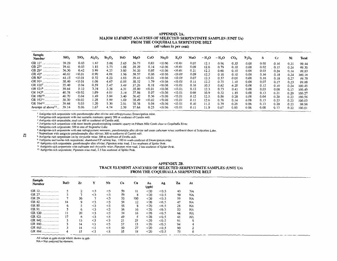
MAJOR ELEMENT ANALYSES OF SELECTED SERPENTINITE SAMPLES (UNIT Us) APPENDIX 2A.
FROM THE COQUIHALLA SERPENTINE BELT (all values in per cent)
~ , ~~~ ~~,
Sample Number
GR 121 ..................... GR 272 ..................... GR 293 .....................
GR I 6 4 l 2 .................. Average of abovve'3 ...
sio, 39.29 39.41
40.61 36.30
41.15 38.40 35.40
10.78 39.64
30.70 38.30 39.68 39.14
TiOz 0.03 0.03 0.42
<0.01 <0.01 <0.01
0.04
<0.02 0.12
<0.02 0.04
0.03 0.06
40, 1.67 1.15
0.90 5.99
0.32
0.59 I .06
3.34 I .09 1.49 1.28 1.20 1.67
Fez03
5.73 5.06
4.91 4.21
4.23 4.67 5.47 3.36 4.01 3.84 5.99
4.74 s .30
FeO 2.65
3.00 1.06
I .96 I .03 0.93 3.49 4.31 3.14 3.40 1.69 2.01 2.39
MgO 36.73 38.29 36.20
39.41 38.32 37.26 33.80 37.86 36.42 38.49
31.64
38.57
38.38
CaO
0.03 0.14 0.05
<0.01 0.06
1.79
<O.O1 0.18
0.07
c0.02 0.36
0.04 0.23
Na,O
10.06 C0.06 10.06 10.06 <0.06 <0.06
10.06 43.06 10.06 C0.06 <0.06 <0.06
10.06
G O co.01 <0.01 <0.01 <0.01 <0.01
<0.01 4 . 0 1 <0.01 <0.01 10.01 10.01 io .01
<a.o1
MnO 0.07 0.09 0.21 0.09 0.07 0.11 0.16 0.12
~~
0.09 0.12 0.11 0.10 0.11
+ H,O 12.1 12.0
12.2 12.2
12.3 12.2 10.5 12.3 10.9 12.5 12.6 11.5 11.9
- HzO 0.96 0.79 0.60 0.10 0.57 0.75 0.62 0.73
0.86 0.52
0.76 0.79 0.67
0.35
0.10 0. 10
0. I0 0.01
6.20 1.10
0.41 1.19 ~~
0.28 0.14
0.85 0.29
P A 0.08 0.08 0.08
0.08 0.08 0.08 0.08 0.08 0.08 0.08 0.08 0.08
0.08
S 0.05 0.02 0.03 0.16 0.16 0.07 0.12 0.03 0.13 0.04 0.13
0.08 0.13
Cr 0.16 0.15 0.24 0.18 0.18
0.10 0.17
0.21 0.08
0.20 0.23
0.17 0.20
NI
0.21 0.24 0.14 0.24 0.27 0.23 0.24 0.17 0.20 0.23 0.23 0.23 0.22
Total
99.44 99.30 99.63
100.16
99.88 99.78
100.45 100.49 100.27 100.56 100.03
100.01 99.96
TRACE ELEMENT ANALYSES OF SELECTED SERPENTINITE SAMPLES (UNIT Us) APPENDIX ZB.
FROM THE COQUIHALLA SERPENTINE BELT
Sample Number BaO Zr Y Nb Co Cu Au Ag Zn As
(PPb) GR12 ....................... 5 2 c3 <S 59 I I < m e n s 41 N A - .... " .. GR 27 ....................... 3 1 c3 <5 GR 29 7
59 8 120 10 .5 SO NA
GR42 14 30 1 <5 55 100 <20 10.5 59 NA 9 ....................... c 3
GR 80 ....................... 6 5 C5
<3 58 12 <20 <0.5 47 NA
GR91 5 1 5 58
6 c 3 8 1 2 0 <0.5
....................... 1 5 56 16 <20 10.5 28 NA 53 NA
.~ ~~
.......................
GR 120 ..................... 11 20 <3 GR121 17
<j 6
74 16 C20 10.5 <3
66 NA ..................... <5
GR I42 ..................... 3 13 <3 <5 49 5 c20 4 . 5 41 NA
GR160 ..................... 3 14 (3 <5 21 25 <20 10.5 91 57
8 13 <20 <0.5
GR163 ..................... 3 14 94
c3 4
GR164 4 <5 50
..................... 15 1 3 27 <20 C0.5 90
<5 2
55 18 <20 10.5 75 6

ANALYSIS OF ALTERED GREENSTONE DYKE INTRUDING SERPENTINITE APPENDIX 3.
N!MR CAR0L.IN MINE .- ............ ..
Sample Number
~
SiO, TiO, AI,O, Fe,O, FeO MgO CaO Na,O K 2 0 MnO +H,O -H,O s co* Au Total
GR183 ........................ 39.11 1.12 7.49 10.76 0.95 4.78 33.71 0.05 0.01 0.20 1.57 0.12 0.41 (eem)
_ _ ~ 0.08 <0.02 100.36
._ ...
All d u e s (erccpt Aul in per cent.
~~~ ~-
ANALYSES OF GABBRO-MICROGABBRO ROCKS (Ug) WITHIN THE COQUIHALLA APPENDIX 4.
SERPENTINE BELT COMPARED TO AVERAGE GABBROL5
Sample Number SiO,
?,? GR 43' ....................... 50.19 GR812 ........................ 48.73 GR903 ....................... 49.07 GR 1434 .................... 49.77 GR 144' ................... 46.64 GR145" ...................... 48.64 GR 146 ' ..................... 43.59 GR 1558 ....................... 51.36 GR 1569 .................... 49.85 GR 156A' O . . . . . . ........... 49.18 GR 161" ..................... 51.24 GR 16212 .................. 50.06 GR 16513 .................... 52.69 Averageof abovcI4 ....... 49.31
......... 50. 14
TiO, AI,O,
1.66 13.15 1.37 14.44 1.53 14.57 1.93 14.12 1.66 14.31
1.32 13.11 1.88 14.63
1.64 13.92 1.48 14.07 1.56 14.56 1.56 13.57
1.24 14.06 1.94 13.85
1.60 14.03 1.12 15.48
. ~ . ~
Fe,O, FeO MgO
(all values in per cent) ~~
1.31 9.03 7.16 1.21 8.25 6.92 1.06 9.33 6.91 2.54 9.61 5.63 2.10 8.65 6.12 1.33 9.84 6.77 2.23 8.32 7.25 2.16 9.48 4.86 3.59 7.83 6.06 2.25 8.87 6.03 1.41 9.9s 5.72 1.64 10.70 5.13 1.59 8.39 5.47
3.01 7.62 7.59 1.88 9.09 6.16
CaO Na,O K,O
9.66 4.09 0.06 11.09 3.60 0.12 10.36 4.02 0.13
14.08 3.13 0.24 9.19 4.27 0.17
19.27 2.20 0.18 9.24 4.12 0.23
10.1 I 8.93 4.93 0.23
10.37 3.7? 0.10 3.82 0.13
8.54 4.40 0.19 7.77 4.56 0.18 7.58 5.79 0.19
10.47 4.05 0.16 9.58 2.39 0.93
MnO 0.19 0.18 0.20 0.20 0.19 0.20 0.19 0.20 0.19 0.19 0.20 0.21 0.19 0.19 0.12
COz +H,O - H 2 0
0.10 2.24 0.18 0.14 0.16 0.12 0.13 0.27
2.10 0.13
0.47 1.99 0.06
0.20 2.16 0.10 1.32 0.14
0.67 1.57 0.23 0.40 1.27 0.07 0.31 1.82 0.10 0.27 1.66 0.07 0.14 4.1 I 0.11 0.07 2.77 0.16 0.17 1.75 0.09 0.26 1.92 0.12 0.07
__
P*O5 0.08 0.08
0.37 0.08
0.20 0.08 0.08 0.23 0.21 0.23 0.18 0.08 0.08 0.15
__
s 0.15 0.03 0.01 0.01 0.01 0.02 0.01 0.01 0.01 0.01
0.01 0.01
0.01 0.02
-
Total
99.25 96.44 99.60
100.13 99.27
100.23 99.43
99.69 99.60
101.37 99.08
99.14 99.30 99.42
~

APPENDIX 5A. MAJOR ELEMENT ANALYSES OF FUCHSITE-BEARING QUARTZ CARBONATE (LISTWANITE)
ROCKS (UNIT Urn) WITHIN THE COOUIHALLA SERPENTINE BELT - (all values in per cent)
Sample Number SiO, TiO, Al,03 Fe20, FeO MgO CaO Na,O K 2 0 MnO +H20 -H,O CO, P,O, S Cr Ni Total
................... GR 154' 39.44 0.08 2.71 0.26 4.41 21.47 2.02 1.28 0.11 0.08 0.27 0.16 27.8 0.08 0.05 0.09 0.12 100.43 GR I531 38.68 0.19 3.51 0.77 4.44 22.38 0.85 0.31 0.67 0.74 0.79 0.16 26.5 0.08 0.02 0.14 0.13 100.36
...................
APPENDIX 5B. TRACE ELEMENT ANALYSES OF FUCHSITE BEARING QUARTZ CARBONATE (LISTWANITE)
ROCKS WITHIN THE COQUIHALLA SERPENTINE BELT
Sample Number BaO Zr Y Nb Co Cu Au Ag Zn As Hg
(ppb) GR153 ..................... 69 13 GR154 ..................... 42 70 976 <20
<2 <IO 35 5
22 <0.3 0.8 <2 <IO 37
69 7 <0.3 0.5
700 <20
All values in ppm except Hg in ppb.
m P
ANALYSES OF THE SPIDER PEAK FORMATION VOLCANIC GREENSTONES (UNIT TV) APPENDIX 6.
COMPARED WITH AVERAGE SPILITE' AND BASALTZ
Sample Number SiO,
GR533 .................... 48.01 G R W .................... 50.77 GR I l l s .................. 53.53 GR 11Z6 .................. 50.86 GR 130 .................. 48.58 GR 1398 .................. 51.12
GR 148l0 49.08 1409 46.26 ..................
................ GR
GR 148A" ............. 48.65 GR 14912 ................ 50.29 Average of abovet3 49.71 Average spilitel ....... 49.65 Average basalt2 ....... 49.20
TiO,
1.63 1.53 1.17 1.16 1.79 1.22 1.81 1.87 1.86 I .67 1.57 1.57 1.84
A L A 16.19 14.48 16.05 13.93 14.81 16.64 13.27 14.38 13.90 14.73 14.84 16.00 15.74
F e Z 4 0.85
0.88 I .69
0.74 1.78
0.64 1.22
1.72 1.53 0.92 1.19 3.85 3.79
~
FeO
9.67 7.31 8.05
10.10 8.67
8.44
9.01 8.84
9.11 9.03 8.82 6.08 7.13 -
WJ 7.97 6.24 6.25 5.66 7.33 6.59 6.60 7.36 7.41 7.85 6.93 5.10 6.73 -
CaO
4.28 6.97 3.35 6.91 6.86 3.57 7.40 8.87 8.75 5.76 6.27 6.62 9.47
-
Average of 330 basalt samples (Le Maitre, 1976). Vesicular. pillowed greenstone: Carolin mine vicinity. Augite-bearing greenstone: 1.5 km east of Serpentine Lake.
6 Massive greenstone: 1300 m northwest of Emancipation mini Massive greenstone: 1300 m northwest of Emancipation mine
I Average oi92spilite samples (Vallance, 1960).
Na,O K,O MnO
4.66 0.78 0.18
5.93 0.08 0.15 5.70 0.08 0.18 4.58 0.06 0.19 6.01 0.15 0.16
4.09 0.08 0.19 3.51 0.69 0.17
4.74 0.17 0.19 4.87 0.26 0.18
2.91 1.10 0.20
5.46 0.43 0.19
3.98 0.09 0.20
4.29 1.28 0.15
+H,O -H,O CO, P205 S Zr Y Cr Total
4.21 0.20 0.57 0.08 0.01 107 41 251 99.29 37 228 99.47
3.09 1.24 0.35 0.08 0.02 62 27 215 100.21 2.47 0.99 0.87 0.08 0.01 92
2.47 0.99 2.40 0.08 0.30 63 31 125 100.13 3.34 0.20 0.01 0.08 0.11 96 39 3.59 0.26 0.70 0.08 0.22 74
69 99.84 23
4.14 0.25 4.90 0.08 0.04 107 77 99.97
45 165 98.61
2.23 0.22 0.41 0.23 0.49 102 43 182 100.31 39 182 99.09
3.10 0.46 1.15 0.11 0.17 90 3.49 NA 1.63 0.26 NA
35 161 99.65
0.95 0.43 0.11 0.35 NA
2.38 0.18 0.38 0.20 0.51 122
3.13 0.14 0.87 0.08 0.01 80 31 119 99.58
Greenstone with tectonic brecciation: from drill core 900 m South of Pipestem mine. Augite-bearing greenstone with aquagene brecciation: Camlin mine vicinity.
Masaive greenstone: from drill core 900 m south of Pipcsrcm mine. lo Ma~sive greenstone: 604 m SOUth-southeasI of Emancipation mine. I I Massive greensrone: 650 m SOUth-soulheasI of Emancipation mine. 12 Weakly layered and pillowed greenstone: 600 m southeast of Emancipation mine.
Average of 10 sampler (3-12) above.

MAJOR ELEMENT ANALYSES OF MINOR FELSIC INTRUSIONS (UNIT p) APPENDIX 7A.
WITHIN THE LADNER GROUP (all values in per cent)
~~ ~~~ ~ ..........
Sample Numbex SiO, TiO, AI,O, Fe,O, FeO MgO CaO Na,O K,O MnO + H 2 0 CO, PzOs S Total
GR231 .......................... 57.87 GR952 53.52
1 .w 18.50 0.50 3.64 2.53 2.85 6.80 0.69 1.12 19.66 1.22
0.04 .......................... 5.38 3.89 I .07
1.87 2.61 0.23 0.46 99.59
GR1363 ........................ 57.59 0.83 17.37 0.55 4.87 3.93 2.39 7.07 0.25 0.03 6.40
3.15 0.16
1.78 0.23 0.07
0.68 0.67
99.05 1.65 0.18 0.11 96.77
GR 329' ......................... 64.51 0.86 GR3134 60.56 0.52
17.75 16.24 0.64
2.28 2.55 1.95 I .43 0.10 N A 0.41
I .83 8.61
3.53 0.34
6.17 0.07
I .21 NA
0.05 NA NA
4.31 N A N A 97.61 98.31
....................... ~
2 Feldspar-porphyritic, quanz-deficient sill: Emancipation mine road. 1 . 1 km norih~northea~f of Emancipation mine. I Feldspar porphyry sill wilh minor pyrite: Carolin mine road. I . I km northeast of Carolin mine.
3 Feldspar porphyry with race q u a m phenocrysts: Coquihrlla valley, 350 m Swlh-soulhwes of confluence of Ladner Creek and Coquihalla River. 4 Feldspar porphyry sill: 4 km northeast of confluence of Gill Creek and Frasei River.
TRACE ELEMENT ANALYSES OF MINOR FELSIC INTRUSIONS (UNIT P) APPENDIX 7B.
WITHIN THE LADNER GROUP
Sample Number All Ag As CO Cr CU MO Ni Pb Zn
(wb) Hg
GR23 .......................... <20 GR95 <20
0.5 0.5
87 11 18 165
30 ............................ 18
<3 18 13 95 39
<IO
GR136 ........................... <20 <0.5 30 13 56 <3 14 89
31 51
9 <3 29 IO 76 16 13
(mb)
AU and Hg in ppb, all other elements in ppm. For localion of sampler see Appendix 7A.
MAJOR ELEMENT ANALYSES OF SPIDER PEAK FORMATION WITHIN THRUST SLICES AT CAROLlN MINE APPENDIX 7C.
(values in per cent)
Sample Number SiO, TiO, AI,O, Fe,O,T MgO CaO Na,O K,O MnO CO, S Lo1 Total
GR660 .................... 53.66 1.52 15.53 12.63 4.02 1.95 6.16 0.54 0.17 0.64 0.02 4.02 100.86 GR674 .................... 50.12 1.65 15.24 14.23 4.42 4.16 4.83 0.49 0.22 1.68 0.10 4.83 101.97 GR675 .................... 54.13 1.47 15.20 13.00 3.38 3.47 5.08 1.00 0.19 0.49 0.02 3.64 101.07
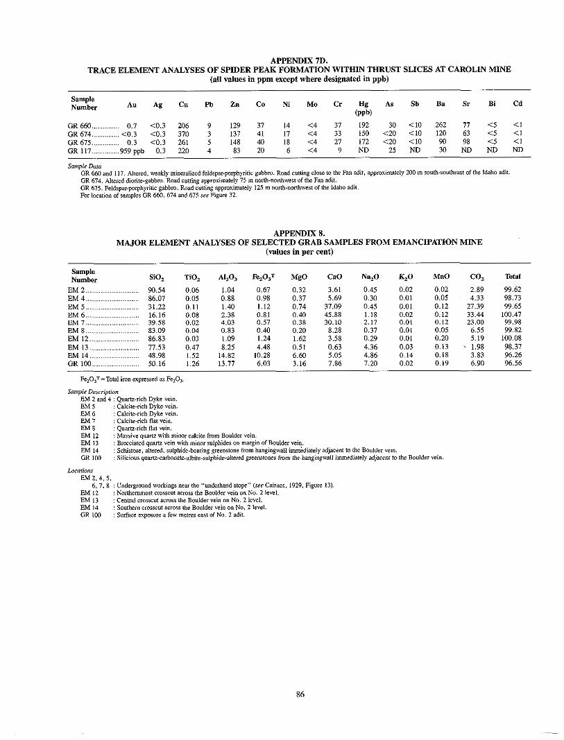
TRACE ELEMENT ANALYSES OF SPIDER PEAK FORMATION WITHIN THRUST SLICES AT CAROLIN MINE APPENDIX 7D.
(all values in ppm except where designated in ppb)
Sample Number Au Ag Cu Pb Zn Co Ni M o Cr Hg As Sb Ba Sr Bi Cd
(wb) GR660 ............... 0.7 <0.3 206 9 129 37 14 <4 37 192 30 <10 262 77 <5 <1 OR674 ............... <0.3 <0.3 370 3 137 41 17 <4 33 150 <20 <IO 120 63 <5 <1 OR675 ............... 0.3 <0.3 261 5 148 40 18 <4 27 172 <20 <IO 90 98 <5 <1 GR 117 ............... 959oob 0.3 220 4 83 20 6 <4 9 ND 25 ND 30 ND ND ND
Sompie Dora GR 660 and 117. Altered, weakly mineralized fcldspar-porphyritic gabbro. Road curling close to the Fan adit. approximately 200 m South-SOUlheaSt of thc Idaho adit. GR 674. Altered diorite-gabbro. Road cutting approximately 75 m north-northwest ofthe Fan adit. GR 675. Feldspar-porphyritic gabbro. Road cutling approximately 125 m norlh-nonhwesr of lhe Idaho adil. For localion of sampler GR 660, 674 and 675 see Figure 32.
APPENDIX 8. MAJOR ELEMENT ANALYSES OF SELECTED GRAB SAMPLES FROM EMANCIPATION MINE
(values in per cent)
Sample Number SiO, TiO, AI,O, Fe,OST MgO CaO Na,O K 2 0 MnO CO, Tafal
EM2 ............................. 90.54 0.06 EM4 86.07 0.05
1.04 0.88
0.67 0.32 3.61 0.98
0.45 ............................. 0.37 5.69 0.30
0.02 0.01
0.02 0.05
2.89 99.62
EM5 ............................. 31.22 0.11 1.40 1.12 0.74 37.09 0.45 0.01 4.33 98.73
EM6 ............................. 16.16 0.08 2.38 0.81 0.12 27.39 99.65
E M 7 ............................. 39.58 0.02 4.03 0.57 0.40 45.88 1.18 0.02 0.12 33.44 100.47
EM8 83.09 0.04 0.83 0.38 30.10
0.40 2.17
0.20 0.01 0.12 23.00 99.98
............................. 8.28 EM12 ........................... 86.83 0.03 I .09 I .24 1.62 3.58 0.29 0.01
0.37 0.01 0.05 6.55 99.82 0.20 5.19 100.08
EM13 ........................... 77.53 0.47 8.25 EM14 48.98 1.52 14.82 10.28
4.48 0.51 0.63 4.36 0.03 0.13 . 1.98 98.37 ........................... 6.60
GR 100 .......................... 50.16 1.26 13.77 6.03 7.86 7.20 5.05
3.16 4.86 0.14
0.02 0.18 0.19
3.83 96.26 6.90 96.56
Fe,O,T=Total iron expressed as Fe,O,.
Sampie Description EM 2 and 4 : Quartz-rich Dyke vein. EM 5 : Calcile-rich Dvke vein. EM 6 : Calcite-rich Dyke vein. EM 7 : Calcite-rich flat vein. EM 8 : Quarrz-rich flat vein. EM I2 : Massive quartz with minor calcile h m Boulder vein. EM 13 : Brecciated quartz vein with minor sulphiden on m q i n of Boulder vein. EM 14 : Schistose, altered. sulphide-bearing greenstone from hangingwall immediately adjacent to the Boulder vein. GR IO0 : Silicious quariz-carbonate-albit~-~~lphid~-~l~~d greenstones from the hangingwall immediately adjacent to lhe Bouldpr vein.
Locarions EM 2.4,s.
6, 7. 8 : Underground workings near the "underhand slop'' (we Cairnes, 1929. Figure 13). EM I2 : Northemmost CTOSSCL across rhe Boulder vein on No. 2 level. EM 13 : Central E~OSSCUI across the Boulder vein on No. 2 level. EM 14 : Southem C ~ O S E C U ~ BETOSS lhe Boulder vein on No. 2 level. GR I00 : Surface w~osure a few metres east of No. 2 adit.
86

TRACE ELEMENT ANALYSES OF SELECTED GRAB SAMPLES FROM EMANCIPATION MINE APPENDIX 9.
(all values in ppm unless otherwise stated)
EM2 .................... 2.7 1 . 1 E M 4 .................... 17.1 1.8
EM6 .................... 8.9 4.5
EM8 ................... * 14.3 EM12 ................. <0.3 0.5 EM13 .................. <0.3 0.3
EM^ .................... xn.3 0.6
EM^ .................... 3.4 0.5 40 94 22
6
14 5
I I 6 5
63 3
<2 <2 <2 <2 <2 <2 <2 <2
3 3 6
4
7
10 S
16 I 1 4 5
53
750 600 170 115
1200 loo
1200 750
0.37% 650
51 21 I
0.14%
51 68
406
108 75 15
72 12
93 75
10
I44 176
<20 <20
I 60
<20 56
<20
NA NA NA NA NA NA NA NA I .73
10 10
28 13
26 13
41 16
I I7
1071 231
1349 652 284 167 90
EM14 .................. <0.3 <0.3 61 35 <2 5 80 <3 <35 39 <20 NA 0.25 28 140 G R N I ~ ................ <0.3 1.2 <20 25 <2 12 x3 ND 54 6 ND 820 4.39 40 NA
* Sainple partially lost in furnace - circa 60 ppm Au. Te armlyses by hydride method. NA=~rample not analysed forelemenL.
CAROLIN MINE PRODUCTION FROM JANUARY 1982 TO SEPTEMBER 19841 APPENDIX 10.
Tonnes' Milled
82 968 19 985 20 045 19 521 27 861
33 377 31 042
~
234 799 ~
~
35 309
16 243 Nil 27 722 35 869 33 512 38 739 31 810 35 645 32 27 I 24 704
35 050
~
346 874 ~ __
30 591 19 212
33 463 30 014 34 212 29 362 25 71 I
7 733 7 148
~
217 446
799 I19 ~ ___ ~
~
2.88 2.36 2.26
253.21 ~
~
69.73 63.94 40.55
- 2.81 2.84
28.92
2.95 44.29
3.15 50.07 3.02 60.80 2.91 59.50 3.59 81.64 3.70 a 9 9
615.51
67.96 76.38 79.46 75.14 73.30 40.37
21.92 10.63
-
55.08
~
~
~
4.04 3.98 3.46 4.01
3.70 2.91 3.01 3.32
3.70
40.12
~
485.28
1354.00 ~
~
__ ~
87

APPENDIX 11A . WHOLE-ROCK ANALYSES* OF SAMPLES COLLECTED FROM DRILLHOLE IU491. CAROLIN MINE
Sample Number SiV. A1.V. Fe. V3T MgV CaV Na. V K2V TiV. MnV N ~ . 0 ~ ~ l ~ ( ~ )
K. O/ Distance up
IU49-1 .......................... 56.14 16.22 8.43 3.70 2.33 5.27 I . 46 1.03 0.07 0.28 0.5 IU49-2 .......................... IU49-3 .......................... 1 ~ 4 9 - 4 .......................... IU49-5 .......................... IU49-6 ..........................
IU49-8 IU49-7
IU49-9 ..........................
..........................
..........................
54.17 53.56 50.86
48.26 50.36
55.67 50.56 55.21
17.7 15.67 15.07 16.66 15.41 14.12 14.18 15.50
9.84 6.93 6.42 9.34 8.34 5.21 6.56 5.75
4.28 2.56
2.35 1.93
1.73 1.75 1.50
2.03
5.82 1.94
7.78 4.71 5.68
7.06 5.49
3.95
5.08 6.12 7.17 6.92 6.83 7.72 7.39 8.03
0.59 1.71
0.37 0.52 0.93 0.13
0.28 0.35
0.81 1.09
0.85 0.96 0.86 0.68 0.74 0.89
0.08 0.15 0.22 0.14 0.17 11.14 0.12 0.12
0.34
0.05 0.07 0.13 0.01
0.09
0.05 0.03
2.5 5.0 7.0 8.0 9.5
12.0 13.5
10.5
IU49-IO ........................ 65.67 14.35 3.73 0.60 1.76 7.77 0.11 0.43 0.04 0.01 14.5 IU49-I1 ........................ 69.94 IU49-12 ........................ 71.12 IU49-13 ........................ 46.24 IU49-14 ........................ 63.81 IU49-15 ........................ 55.20 IU49-I6 ........................ 56.99 IU49-17 ........................ 58.89
11.86 9.41
10.33 14.29 15.32 14.57 15.72
4.89 2.55 6.16 6.5 7.48 5.42 5.35
1.49 1.16 3.03 1.93
1.22 0.89
1.90
3.02
13.21 2.59
2.33 5.71 6.98 4.98
4.02 6.22 4.91 6.56 6.04 5.51 6.49
0.11 0.09 0.13 0.11 0.54
1.29 1.02
0.62 0.31 0.57
0.79 0.73
0.73 0.89
0.05 0.06 0.19 0.05 0.15 0.14 0.13
0.02
0.03 0.01
0.02 0.09 0.18 0.19
16.5 17.5
22.0 18.5
24.0 25.5 27.0
IU49-18 ........................ 65.02 13.68 6.29 0.88 2.65 5.60 0.70 0.68 IU49-19 58.15 15.31 5.57 0.70 5.83 5.40 1.68 0.94 0.11 11149-20 ........................ 43.22 12.06 4.03 0.72 18.53 4.14 1.71 0.79 0.35
0.10 0.12 0.31 0.24 34.0
29.0 30.5 ........................
I Hole IU49 is an inclined upward hole (ret Figure 298) .
Fe,O, T=Tolal imnenpressed as Fe20 ,. * Analytical m u h s in per cent .
WHOLE-ROCK ANALYSES* OF SAMPLES FROM DRILLHOLE IU.531, CAROLIN MINE APPENDIX l l B .
Sample Number SiV.
IU53-I .......................... 60.08 lU53-2 .......................... 57.52 IU53-3 .......................... 58.59 IU53-4 .......................... 59.62 IU53-5 .......................... 47.43 IU53-6 .......................... 56.06 IU53-7 .......................... 55.34 IU53-8 .......................... 59.77 IU53-9 .......................... 57.47 IU53-IO ........................ 52.00 IU53-I 1 ........................ 69.80 IU53-12 ........................ 54.20 IU53-13 ........................ 51.20 IU53-14 ........................ 60.83 IU53-15 ........................ 60.11 1U53-16 ........................ 60.98 1U53-17 ........................ 60.94 1U53-18 ........................ 59.91
1U53-20 ........................ 49.08 11153-21 ........................ 58.33 11153-22 ........................ 57.45 IU53-23 ........................ 64.16
1~53.19 ........................ 60.97
IU53-24 ........................ 56.94 1U53-25 ........................ 55.15 11153-26 ........................ 57.68 IU53-27 ........................ 51.51 IU53-28 ........................ 58.51 IU53-29 ........................ 54.73 IU53-30 ........................ 54.03
A I A 12.78 17.34 16.5 13.43 14.95 17.30 17.36 16.38 17.55 12.70 10.76 17.22 16.51 13.20 14.58 15.57 13.39 14.78 16.21 14.37 16.24 15.86 17.37 17.18 17.53 15.77 16.12 16.01 16.71 17.77
Fe@. . 5.58 8.34
7.55 7.67 8.91
8.04 8.40
9.07 10.56 3.11
10.71 9.97
6.85 8.76 7.68 7.05 6.70 8.30
10.01 8.27 7.75
9.90 9.49
10.50 9.26 8.69 7.80
9.96 5.02
7.60
MgO 2.17 3.50 3.13 3.77 3.44 3.76 3.55 3.35 3.96 3.19 1.16 2.48 2.87 2.63 3.25 2.85 2.94 2.95 3.52 2.72 3.54 3.11 3.44 3.27 3.32 2.82 2.39 2.18 1.29 3.01
CaO
3.91
1.97 9.32 9.39 1.51 2.33 0.91 0.44 5.31 3.37 1.95 3.67 4.05 I . 90
3.80 1.16
3.01 I . 60 4.79 2.37 2.14
I . 20 1.35
1.57 2.58 6.59 2.01 6.40 2.52
0.93
Na20
6.64 7.84 6.32 3.70 4.67 6.48 7.07 6.97 7.31 6.13 6.25 8.12 7.31 5.61 5.94 6.46 4.37 4.75 6.07 4.75 5.89 6.21 5.51 5.81 6.12 5.71 5.76 6.78 5.93 6.71
KzO 0.38 0.26 1.17 1.73 1.72
0.62 1.42
0.33 0.28 0.11 0.17
0.17 0.12
0.60 1.13
0.52 1.49
2.46 0.80 0.78 1.39 I . 20
1.01
0.20
0.12
I . no 1.06 0.60 2.08 0.55
TlV.
0.71 0.66 0.74 0.68 0.75 0.78 0.70 0.80 0.94 0.35 0.75 0.75 0.55 0.74 0.66
0.62
0.73 0.71 0.70 0.74 0.73 0.66 0.59 0.74 0.72 0.82 0.86
0.60
0.58
0.70
MnV
0.09 0.07 0.09 0.13 0.35 0.08 0.12 0.13 0.10 0.13 0.06 0.11 0.14 0.10 0.10 0.06
0.10 0.10 0.09
0.10
0.11 0.10
0.11 0.10
0.13 0.12
0.11 0.18
0.13 0.10
Na. V Hole (m) K. VI Distance down
0.06 0.5
0.18 7.0 1.9
0.47 0.37
8.5 125
0.22 14.5
0.113
0.09 0.05 21.5
16.5
0.04 26.0 0.02 27.7 0.03 11.0 0.02 31.9 0.02 35.0 0.02 39.5 0.02 42.0 0.09 46.0 0.26 49.5 0.31 53.7
51.5 60.3
0.12 63.0 0.25 66.2 0.22 73.0 0.16 78.0 0.17 80.0 0.18 84.0 0.08 90.3 0.35 87.0
0.08 57.6 11.52 0.13
0.08 95.0
* Analytical reSultS in per cent . 1 Hole IU53 is an inclined downward hole (see Figure 298) . Fe,O, ==Total iron expressed as FhO. .
88

Sample Number
APPENDIX 11C . TRACE ELEMENT AND OTHER ANALYTICAL DATA OF SAMPLES COLLECTED
FROM DRILLHOLE IU49. CAROLIN MINE - ...... ..... - ..
AI3 Ag AS CU
IU49-I ..................... 0.24 <0.3 3 IU49-2 ........................ 0.29 <0.3 lU49-3 ................... 0.20 0.8
2
IU49-4 11.99 8
1U49-5 1.42 4.6 0.11%
11149-6 4.24 1 . 0 590
........................ 1.2 0.43% IU49-7~ .................... 1.70 1.1 0.87%
.......................
.....................
IU49-8 ...................... 2.40 1.8 10.2%
89 93 63 67 92
43 71
99 IU49-9 ...................... 1.29 1.1 2.11% 108 IU49-IO ................... 1~49-11 .................. IU49-I2 ................. Iu49- 13 .................. 11149-14 ................... IU49-15 ..................... 11149-16 ..................... lU49-17 ...................... IU49-18 .....................
11.75 0.10 0.02 0.07
<0.02 0.03
<0.02 0.12 0.16
<0.3 2.6
<0.3 0.8
<0.3 0.4
<0.3 0.5 0.5
2.67% 0.16%
959 36
24 25
13 14 16
79 13
36 55 61 53 52 61 60
IU49-19 ................... <0.02 <0.3 IU49-20 <0.02 <0.3
26 55 ..................... 18 66
Values in ppm encepr where noted in ppb or % .
< I 5 < I 5 <I5
35 <I5 <I5 <I5
23 <I5 <I5
<I5 88
< I 5 15
<I5 17
32 17
<IS 15
105 93
95 90
103 97 68 78 78 51 76 32 87
108 81 78 78 90 72 69
M O
<2 <2 < 2 <2
2 <2 15
25 16
80 8 6
<2 2
< 2 <2 <2
2 2
<2
Sh
2 1 1 3 3 7
13.6 12.3 16.7 18.5 4.0
< I I
< I 1
<1 < I <I I
Ph
3 2 4
<2 4
4 4 4 4 4 4 3 7
BaO
681 580
93 70 80 93 40 63 70 45 60 38 56 37
240 513 670 357 815 770
Sr
221
204 173
250 202 190 I90 225 168 I12 I42 I44 398 206 I 94 176 142 I 24
218 190
Ni
7 5
15 5
1 1 6
21 12 8 5
10 7 4
~
co
17 15 15 18 18 18 15 15 15 IO 15
10 7
13 19 13 12 18 13 13
4.9 6.5 5.0 7.5 7.0 7.6 3 . I
4.2 2.2
13.4 4 .I
2.6 4.5 5.5 3.8 2.4 4.5
13.5
(%I (%I (%I S H. O + P205
0.75 2.8 0.20 0.74 0.37
3.3 0.20
1.17 2.5 0.30
1.07 1 . 3 0.44 1.9 0.20
2.39 1.98
1 . 1 0.20
3.00 0.3 0.16 0.6 0.10
2.02 0.4 0.17 I . 27 I . 49
0.3 0.28
0.55 1.1 0.04
0.76 0.3 0.01 1.0 0.26
0.97 0.4 0.10
0 . I6 0.18 2.3 0.21
1.9 0.13 0.20 1.5 0.16 0.64 1.6 0.12 0.52 1.4 0.20 0.08 1 . 3 0.25
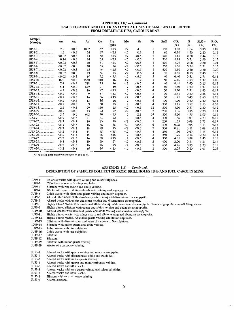
TRACE ELEMENT AND OTHER ANALYTICAL DATA OF SAMPLES COLLECTED APPENDIX 11C - Continued.
FROM DRILLHOLE IU53, CAROLIN MlNE
Sample Nllmhsr Au Ag AS Cu Hg
............. IU53-4 0.14 X0.3
<0.02 <0.3 14 68 <IS <2 < O S ...................... 14 65 C I S <2 < O S
7 500 1.65 0.30 2.44 0.16 8 700 6.93 0.71 2.90 0.17
IU53-5 ...................... <0.02 <0.3 IU83-6 <0.02 <0.3
I O I O
81 <I8 <2 < o s 4 500 7.22 0.08 2.80 0.21 ...................... 68 16 <2 <0.8 2 500 1.36 0.74 2.71 0.15
IU53-7 ......................
IU83-9 IU53-8
1u53-10 .................... IU83-ll .................... IU53-12 ....................
......................
......................
<0.02
<0.02 <0.02
16.0 7.4 8.4
<0.3 ...
co.3 <0.3 <0.3 <0.3
15 13 IA
1550 718 649
..
49 66
310 92
38 91
<I5 15
CIS 16 16 19
<2 a . 5
<2 < o s <2 0.6
<2 <2 <0.8
1.7
2 <0.8
2 4
600 70 40 50 40
~~~
60
0.95 I .90
0.40 6.16 4.41 I .80
0.40 0.15 0.33 2.80 1 .XI 1.90
~~ ~
2.70 2.45 2.71
0.15 1.32
1.97
0.20 0.16 0. I6 0.06 0.13 0.17
~ ~~
11183-13 .................... 4.2 <0.3 16 IU53-I4 4 . 2 <0.3
97 <I8 2 a . 5 4 9
50 3.70 1.31 1.63 0.17 .................... 57 < I 8 <2 <0.8
IU53-18 .................... <0.2 <0.3 14 3 30 3.41 0.50 2.28 0.11
66 < I 5 <2 <0.8 4 30 1.91 0.48 2.60 0.20 IU83-16 .................... <0.2 IU83-17 .................... <0.2 IU53-18 .................... 2.5
IU53-20 2.8 IU83-19 4 . 2
IU83-21 .................... <0.2
....................
....................
<0.3 <0.3 <0.3 <0.3
<0.3 0.4
13 9
29
642 13
21
86 60
130 74 90 83
2 <0.8 <2 <0.8 <2 <0.8
2 2.1 2 <0.5
4 6
12 2
34 4
1 on 300 800
800 200
300
." 3.15 I .90
3.30 1.36 6.30 1.68
0.80 0.52 0.37 0.05 4.58 0.03
~ ~~
2.40 2.13 2.30 2.70 1.05 2.70
0.11 0.53 0.12 0.14 0.14 0.15
IU83-22 .................... <0.2 <0.3 16 IU53-23 <0.2 <0.3
83 16 <2 <0.8 18
8 200 1.38 0.09 2.73 0.17 .................... 88 35 <2 < o s
IU53-24 .................... <0.2 <0.3 18 79 18 <2 <0.8 7 300 0.81 0.11 3.08 0.12 6 400 0.95 0.06 3.13 0.13
IU53-25 .................... <0.2 <0.3 14 65 < I 5 <2 <0.8 IU53-26 .................... <0.2 <0.3 18
4 280 1.10 0.09 3.15 0.11
1U53-27 <0.2 4 . 3 66 <I5 2 <0.5 2 250 1.25 0.14 2.70 0.11
................ 14 68 < I 8 2 <0.5 4 3no 4.91 0.08 2.48 0.19 IU53-28 .................... 0.8 <0.3 79 27 <2 <0.5 19 2 400 2.00 0.31 1.81 0.14 IU53-29 .................... <0.2 C0.3 16 IUS3-30 .................... <0.2 4 . 3 16
76 28 <2 < O S 86 <15 <2 <0.5
5 600 4.76 0.08 1.73 0.18 2 300 2.08 0.20 3.01 0.25
~~ ~~~ ~~ ~ ~~
DESCRIPTION OF SAMPLES COLLECTED FROM DRILLHOLES IU49 AND IU53, CAROLIN MINE APPENDIX 11C - Continued.
IU49-I IU49-2 IU49-3
IU49-5 IU49-4
IU49-6 IU49-7 11149-8 11149-9 IU49-IO IU49- I I IU49.12 IU49.13 IU49.14 IU49-15 IU49-16 IU49-17 IU49-18 IU49.19 IU49-20
IU83-I
IU53-3 lU53-2
IU53-4 IU53-5 IU53-6 IU53-7 IU53.8 IU53-9
Chloritic wacke with quartz veining and minor sulphides. Chloritic siltstone with minor sulphides. Siltstone with rare quartz and albite veining.
Lithic wacke with albite and quartz veining and minor sulphides. Wacke with quartz, albite and carbonate veining and arsenopyrite.
Altered lithic wacke with abundant quartz veining and disseminated arsenopyrite. Altered wacke with quartz and albite veining and disseminated arsenopyrite. Highly altered wacke with quam and albite veining, and disseminated arsenopyrite. Traces of graphitic material along shears Highly altered siltstone with quartz and albitic veining and abundant arsenopyrite. Altered wackes with abundant quartz and albite veining and abundant arsenopyrite. Highly altered wacke with minor quartz and albite veining and abundant arsenopyrite. Highly altered wacke. Abundant quartz veining and minor sulphides. Siltstone with dissemination and veins of carbonate. No sulphides. Siltstone with minor quartz and albite veining. Lithic wacke with rare sulphides. Lithic wacke with rare sulphides. Siltstone, Siltstone. Siltstone with minor quartz veining. Wacke with carbonate veining.
Altered wacke with quartz veining and minor arsenopyrite. Altered wacke with disseminated albite and sulphides. Altered wacke with minor quartz veining. Altered wacke with quartz and minor carbonate veining. Altered wacke and lithic wacke.
Altered wacke and lithic wacke. Altered wacke with rare quartz veining and minor sulphides
Siltstone with rare carbonate veining. Altered Siltstone.
90

11153-10 11153-1 1 11153-12
11153-14 11153.13
11153-15 11153-16 11153-17 IU53-IS
11153-20 IU53-I9
11153-21 11153-22 11153-23 11153-24 11153-25 11153-26 11153-27 IU53-28 IU53-29 IU53-30
Altered wacke with disseminated sulphides, albite and quartz veining. Minor arsenopyrite. Intensely altered wacke with abundant sulphides and quartz veining. Altered wacke and lithic wacke. Disseminated sulphides, dbite veining and some graphitic material along shears
Thinly bedded siltstone, minor albitic alteration. Siltstone and minor wacke with some quartz veining and sulphides.
Thinly bedded siltstone, minor albitic alteration. Highly cleaved argillite with pyrite. Bedded siltstone. Poorly bedded siltstone, minor sulphides. Poorly bedded siltstone. Highly altered siltstone with abundant sulphides, quartz and carbonate veining. Altered siltstone. Bedded siltstone. Bedded siltstone. Altered wacke. Altered wacke with disseminated albite. Altered wacke. Lithic wacke. Altered siltstone. minor albite veining. Lithic wacke, minor albite veining. Lithic wacke with minor albite and carbonate veining.
All samples contain varying amount^ of albitic alteration.
91

MAJOR ELEMENT ANALYSES OF 72 LITHOGEOCHEMICAL SAMPLES COLLECTED APPENDIX 12A .
FROM THE CAROLIN MINE AREA (See Figure 32 for sample locations.)
(all values in per cent)
Sample Number SO.
GR604 .................... 55.25 GR605 .................... 53.82 GR606 .................... 53.13 GR607 .................... 57.94 GR608 .................... 60.68 GR609 .................... 54.89 GR610 .................... 60.50 GR611 .................... 59.18 GR612 .................... 59.59 GR613 .................... 52.50 GR614 .................... 56.84 GR615 .................... 59.38 GR616 .................... 57.01 GR617 .................... 56.94 GR618 .................... 60.46 GR619 .................... 58.79 GR620 .................... 61.25 GR621 .................... 59.05 OR622 .................... 58.74 GR623 .................... 57.33 GR624 .................... 58.83 GR625 .................... 59.47 GR626 .................... 59.00 OR627 .................... 61.68 GR628 .................... 61.90 GR629 .................... 54.59 GR630 .................... 60.84 GR631 .................... 64.24 GR 632 .................... 60.33 GR633 .................... 40.66 GR634 .................... 56.47 GR635 .................... 48.82 GR636 .................... 48.55 GR637 .................... 37.99 GR638 .................... 49.94 GR639 .................... 52.40 GR640 .................... 56.92 GR641 .................... 61.15 GR642 .................... 62.04 GR643 .................... 69.49 GR644 .................... 59.22 GR645 .................... 57.03 GR646 .................... 57.45 GR 647 .................... 55.18 GR648 .................... 54.88 GR649 .................... 61.21 GR650 .................... 59.86 GR651 .................... 56.55 GR652 .................... 54.56 GR653 .................... 51.64 GR654 .................... 55.96 GR655 .................... 55.92 GR656 .................... 66.11 GR657 .................... 56.82 GR658 .................... 57.46 GR659 .................... 50.65 GR660 .................... 53.66 GR661 .................... 53.91 GR662 .................... 63.25 GR663 .................... 57.58 GR664 .................... 54.83
TiO.
0.51 1.03 1.02 0.92 0.77 0.88 0.77
0.87 1.01
0.83 0.86 0.90 0.96 0.96 0.80
0.99 1.03
1.03 1.03
0.71 1.16
0.88 I . 00
0.74 0.79 0.93 0.90 0.87 0.85 1.41 1.01 1.22 I . 20
0.95 1.47
1 .11 1.04
0.85 1 . 00
0.58 1.07 0.99 1.11 1.50 1.05 0.98 0.89 1.16 1.19 1.56 1.14
0.58 1.19
0.84 0.83 1.19 1.52
0.89 1.20
1.08 1.06
* W 3
19.21 14.83
15.76 17.08
15.93 18.62 15.80 17.13 15.46 16.18 15.30 14.95 16.59 17.07 15.60 17.52 17.29 17.28 17.09 17.55 17.16 16.64 17.59 14.89 15.24 16.65 15.86 15.51 16.92 12.92 17.36 14.08 15.26 11.78 15.27 15.42 16.71 14.98 15.57 13.64 17.21 17.43 18.29 18.25 17.69 17.29 15.90 16.98 17.43 16.58
15.97 15.12
11.56 18.15 17.71 16.04 15.53 17.94 15.87 16.73 16.83
Fe. OZ1
3.80 10.44 9.61 8.57 8.01
10.28 8.12 8.15 8.16 6.55 8.30 8.44 8.82 8.65 6.40 8.56 6.82 8.64 8.16 8.51
7.91 8.77
7.49
7.48 8.19
8.69 7.94 6.24
11.51 5.70
9.11 13.34 7.84
11.01 9.88
9.63 8.23 7.41 7.44 3.83 7.65 8.95 8.42
10.16 9.37 7.19 8.07 8.93 9.27
11.90 8.96
10.56 3.60 7.28 8.32
10.05 12.63 9.30 6.87 8.30 8.27
WJ
3.23 1.46
4.34 3.95 3.24 3.61 4.60 3.18 4.85 2.88 3.21 3.40 3.54 3.56 2.08 3.56 I . 77 3.60 3.25 3.92 4.64 3.33 4.12 4.02 4.53 3.22 3.27
0.60 I . 22
3.80 3.48 3.12 3.20 6.35 1.36
3.18 1.70
2.90 3.11
3.10 1.35
2.94 3.69 3.74 4.30 2.81 3.52 3.62 3.92 3.75 3.00 3.46 1.84 4.18 4.98 3.61 4.02 4.03 2.76 3.58 4.10
CaO
8.53
3.06 1.60
2.08
1.42 I . 46
1.13 1.44 1.61 6.50 3.21
2.97 1.94
2.17
0.66 2.88
0.17 0.40 0.60 0.10 2.50
0.58 1.19
0.95 0.94
0.53 3.21
1.09
10.59 1.23
0.25 5.15 7.49
10.02 3.18 3.46 2.38 I . 36 1.20 0.29 1.67 I . 64 1.38
2.02 1.16
0.99 2.52 2.58 3.13 0.72 3.12 2.73 5.40 3.18 I . 69 5.11 1.95 3.35 0.67 2.45 3.03
Na20
5.96 6.24 4.16 4.94 6.03 5.51 4.47 6.33 3.67 5.41 6.07 5.22 5.12 5.40 7.04 7.45 9.13 6.63
7.53 3.71
2.97 5.77 4.07 4.92 4.33 6.86 6.10 7.77
5.74 9.96
6.20 6.11 7.22 4.65 8.11 7.48 7.16 7.11 5.89
6.15 1.59
6.39 6.23 5.54 6.11 7.59 5.97 6.05 6.09 6.91 6.23 6.14 4.14 3.28 2.43 6.34 6.16 5.63 7.04 6.09 7.05
%O 1.19 1.54 1.87
0.94 1.20
1.58 1.18 1.35 1.42 1.69 1.11 1.21 1.57
0.77 1.85
0.49 0.10
4.11 1.23
0.47 1.59 1.92 1.98 0.58 1.03 1.08 1.19 0.48
0.13 0.06
0.13 2.21
0.10 0.88 0.82 0.68 0.79 0.36 1.08 4.52 I . 71 1.96 1.35 2.21 1.57 0.57 I . 29
0.73 1.16
0.12 0.98 0.64 0.99
2.20 1.91
0.37 0.53
0.87 1.58
0.40 1.39
. ~
MnO 0.070 0.157 0.157 0.108 0.084 0.107 0.099 0.120 0.105 0.128 0.133 0.142 0.150 0.113 0.118 0.147 0.039 0.123 0.114 0.071 0.920 0.144 0.093 0.100 0.091 0.168 0.101 0.074
0.194 0.042
0. 101 0.203 0.207 0.179 0.122 0.170 0.139 0.091 0.111 0.040 0.107 0.127 0.123 0.108
0.100 0.138
0.193 0.154
0.131 0.107 0.168 0.161 0.081 0.076 0.079 0.177 0.174 0.224 0.125 0.147 0.153
. .
Lo1
7.92 3.01 4.34 3.00 2.93 3.41 3.52 2.85 3.94 6.46 4.78 3.04 2.58 2.90 3.60 2.58 2.80 2.33 2.54 3.54 4.71 2.45 3.82 3.17 3.59 3.73 2.26 2.14
10.27 2.06
2.63
7.72 8.31
15.52 7.70 6.45 3.29 3.62 2.49 3.87 2.23 2.76 2.88 2.71 3.38 2.39 2.13 2.99 4.01 6.76 5.53 3.72 5.33 4.95 4.83 5.40 4.20 3.46 I . 66 2.40 3.94
~
Total
99.5 100.3 98.8
100.1 98.5
100.3 100.2 100.7 99.7 99.1 99.8 98.6 99.3 99.6 99.7
100.8 100.3 100.3 99.3
100.2 102.8 99.8 99.6 99.2 99.9 99.1 99.0 99.6 97.8 97.2
100.5 98.8
98.7 98.7 98.5 98.5
99.9 99.8
99.2 99.8
100.1 100.2 100.9 100.5 100.5 101.1 100.3 100.2 100.4 100.0 100.2 100.4 99.6
100.6 100.5
100.3 98.9
100.6 100.0 99.7 99.6
. ~
co. *
0.91 7.24
1.55 0.70 0.84 0.80 1.06 0.91 I . 27 4.78 3.02
0.70 1.13
0.56 2.46 0.70 0.42 0.63 0.28 0.42 4.89 0.63 1.41 0.84 1.27 2.11 0.28
1.32 1 . a0
8.81 0.36 7.19 6.97
14.75 4.74 4.05 1.95
0.80 I . 59
2.31 0.36 0.71
0.14 0.36
1.14 0.78 0.43 1.06
0.71 1.70
2.55 1.13 4.33 2.55
4.32 1.63
0.64
<0.07 1.06
0.50 2.13
. __ S*
0.06 a . 0 1
0.11 0.05 0.02 0.24 0.10 0.07 0.07 0.34 0.10 0.18 0.04 0.09 0.44 0.01 0.65
<0.01 0.02
0.05 0.86
a . 0 1 0.01 0.01 0.04 0.09 0.01 0.80 1.85
0.28 2.87
0.02
0.70 1.21
3.98
0.20 3.37
0.06 2.08
:0.01 0.89
0.20 0.01 0.37 0.17 0.02 0.09 0.11 0.11 2.29
0.14 2.24
0.04 0.07 0.11 0.72 0.02 0.06 0.08 0.12 0.11
Fe.0. T=Tolal iron upressed as Fe.0. .
* Not included in total . WI =Loss on ignition .
92

MAJOR ELEMENT ANALYSES OF 72 LITHOGEOCHEMICAL SAMPLES COLLECTED APPENDIX 12A - Continued
FROM THE CAROLIN MINE AREA (See Figure 32 for sample locations.)
(all values in per cent)
Sample Number SiO, TiO, AI,O, Fe2OST MgO CaO Na,O K,O MnO LO1 Total CO,* S*
GR665 ................... 58.99 0.85 15.32 6.76 3.08 3.13 7.49 0.10 0.117 4.50 100.3 2.84 1.31 GR666 ................. 64.40 0.90 15.61 7.23 2.97 0.64 4.04 1.77 0.066 2.93 100.5 1.21 0.13 GR667 .................... 59.95 0.78 16.90 8.17 3.89 0.98 4.42 1.48 0.091 3.19 99.8 0.78 0.03 GR668 ................. 55.43 0.94 18.66 8.91 4.76 2.59 3.03 1.67 0.088 4.10 100.1 1.63 0.08 GR669 .................... 56.47 0.85 17.64 8.31 5.16 2.32 2.28 2.08 0.089 5.22 100.4 2.27 0.10 GR670 .................... 57.17 0.76 17.43 8.82 5.15 1.95 2.38 1.63 0.080 4.93 100.3 1.70 0.11 GR671 .................... 58.99 1.03 16.83 8.23 3.14 3.20 6.26 1.09 0.148 2.39 101.3 0.71 0.07 GR672 .................... 60.94 0.94 15.16 7.01 2.87 2.81 5.48 1.08 0.124 3.54 99.9 2.12 0.09 GR673 .................... 56.11 1.13 18.61 7.80 4.11 0.24 7.89 0.59 0.076 4.00 100.5 0.49 1.21 GR674 .................... 50.12 1.65 15.24 14.23 4.42 4.16 4.83 0.49 0.220 4.83 100.1 1.68 0.10 GR675 .................... 54.13 1.47 15.20 13.00 3.38 3.47 5.08 1.00 0.190 3.64 100.5 0.49 0.02
Fe,O,T=Toial iron expressed as Fe,03.
* NOI inlcuded in total. LOI=~Lossonignitio”.
93

TRACE ELEMENT ANALYSES OF 12 LITHOGEOCHEMICAL SAMPLES APPENDIX 12B .
COLLECTED FROM THE CAROLIN MINE AREA (See Figure 32 for sample locations) -
OR604 14 OR605 ....................... 128
.. .......................
GR 606 ....................... 9 GR607 ....................... I000 GR608 ....................... 16 GR 609 ..................... 52 ~~~
GR 610 11 OR 611 ....................... 12 OR612 ....................... 25 GR613 ....................... II
.. .......................
GR614 ....................... 8 GR615 ....................... 9 GR616 ....................... <5 GR617 ....................... 7 GR618 ....................... <5
Ag
<0.3 <0.3
<0.3 <0.3
<0.3 C0.3
<0.3 <0.3
<0.3 <0.3 <0.3 <0.3 C0.3 <0.3 4 . 3 <0.3 <0.3 <0.3 <0.3 <0.3 a . 3 <0.3 <0.3 t0.3 <0.3 4 . 3 <0.3 <0.3
0.3
<0.3 1.9
4 . 3 0.7
<0.3 2.1
<0.3 0.7
C0.3 <0.3 4 . 3 <0.3 <0.3 <0.3 <0.3 <0.3 <0.3 C0.3 (0.3 <0.3
0.3 7.0
<0.3 0.6
<0.3 <0.3 <0.3 <0.3 -3.3 <0.3 <0.3 <0.3 <0.3 <0.3
C"
31 58 66 53 79 85 56 50 71 57 55 71
100 72 65
112 64 75 81 54 81 91 34 M)
69 68 68
108 75
197 84
152 95
102 36
113 54 65 82 45 73 88 w 69 56 78 83 66 61
290 78 99 34 58 68
206 95
64 53 58 61 71 59
Pb
10 8
8 7
9 8 6 8 9 8
9 9
8 9 9
10 16 8 6
6 7
7 5 5
30 6
5 7 6
14 8
10 4
14 5
11 5 6
9 7
I I 7 8
10 10 10 8 8 5
I1 5
4 4 6 3
9 7
4 8 9 8
10 7
Zn
117 70
103 107 88
105 131
142 97
85 87
102
101 103
123 99 14
102 92
57 99
100 105
118 128 100 91
116 78
I10 79
101 75 98 52
122 91
102 93 94 94
104 92
108 98 86 85
108 107 110 104 109 69 94
106
129 110
106 92
107 92
109 73
co
24 16
22 22 22 25 24
24 19
25 19
23 23 26 24 20 23 22 20
24
12
20 15
25 18 30
28 32 27
29 29 35
23 35
22 25 19
24 12
25 20 29 24 20
23 25
23 34
27 24
23 26 23 28 31 24
21 24
26 28 20
25 12
Ni
4 26
9 9
21
45 I 1
45 5
6 8
10 19 11 9
25 13 13 3 3 7
10
31 19
38 10 16 20 9
11 12 9
I 1 51 7 3 6
8 6
12 14 12 6
10 26 6 7
5 5 9 7
24 7
40 46
14 6
I1 9
5 3
34 9
Cr
27 <25
25 <25 138
<25 138
<25 120 52 37
70 29
35
121 29
88
<25 29
29 29
123 37
117 90
25 33 40
29 30
<25 25 30
<25 246
<25 33
<25 35
27 76 43 25
<25 31
27 31
<25 29
<25 86
<25 88
113 127
37 25
30 30
<25 31
113 31
( w b ) Hg
302 68
112 198
228 88
I82 130 235 38
200 240
<25 44
1 2 5 <25
74 40 34
62 54
67 30
50
78 34
74 34
108 81
57 64 93 71 82 68 36
238 205
25 162 250 108 170 78 45
107 92 15
155 30
<25 I10
30 30 72
192 23
40 30
112 35
68
GR 624 ....................... 24
GR626 10 GR625 15
OR627 ....................... IO GR628 ....................... <5 GR629 ....................... 8
.......................
.......................
GR 630 ....................... 8 GR631 ....................... 19 GR632 ....................... 1000 GR 633 ....................... 11600 OR634 ....................... 13 GR635 ....................... 8 GR636 ....................... 5800 GR637 ....................... 2700 GR 638 ....................... 15000 GR639 ....................... 5800 GR 640 ....................... 6
GR642 19 GR641 37
GR643 ....................... 15 GR644 ....................... 11 GR645 ....................... 300 GR646 ....................... 134 GR647 ....................... 300
.......................
.......................
GR648 10 GR649 ....................... 1000 GR650 ....................... 1700 GR651 ....................... 19 GR652 ....................... 23 OR653 ....................... 2400 GR654 ....................... 2400
~~
....................... GR648 In ~~
.................... ~~
GR649 1000
GR651 19 GR650 1700
GR652 ....................... 23 OR653 ....................... 2400 GR654 ....................... 2400
.. ....................... ....................... .......................
GR655 ....................... 6 GR656 ....................... 600 GR657 300 GR 658 ....................... 9
GR 660 700 GR659 1000
GR661 ....................... 6 GR662 ....................... 12 OR663 ....................... 300
~~
.......................
.......................
.......................
GR664 ....................... 13 GR 665 ....................... 300 GR666 ....................... 102 ~.
~~
All samples recorded ( 4 ppm Mo. <IO ppm Sb. <5 ppm Bi. <SO ppm Rb and < I ppm Cd . Values in ppm. U O I ~ S E indicated otherwise .
As
<20 <20 1 2 0 <20 <20 <20 <20 1 2 0 <20 <20
<20 <20
<20 a 0 <20 <20 <20 <20 <20 <20
26 <20 1 2 0 c 2 0 <20 <20 <20 <20
0.97% 1.04%
<20
0.90% <20
0.27% 1.82% 1.10% <20
<20 <20
<20 <20 e 2 0 e 2 0 e 2 0 c20 e20
<20 <20
<20 <20 293 e20
<20 <20
c20 290 30
e 2 0 20
<20 20
e 2 0 czo
.
Ba
185 I60
236 159 159 100 249 107 210
236 236
223 197 133 90 80
172 442
80 80
236 172 LOO 90
146 172 90 80 60
365 339 70 80 60
108 623 120 90
867 90
300 146 635 223 133 80
313 249 339 197 146 90
274 120 520 262 417 146 288
1216 80 90
210
Sr
190 114 172 193 90
136 73
125 62
142
67 94
208 109 125 53 38 46 58 48
127 87 38 69 43 69 48 46 45
269 46 73
146 283 120 95 29
133 99
138 195 65 71 94 76
130 62
145 61
144 88
62
230 100
74 195 77
129 63 86 92
140 32
94
...

APPENDIX 12B - Confinned TRACE ELEMENT ANALYSES OF 72 LITHOGEOCHEMICAL SAMPLES
COLLECTED FROM THE CAROLIN MINE AREA (See Figure 32 for sample locations)
~ ~ 6 6 7 ....................... 10 a . 3 114
~ ~ 6 6 9 <5 4 . 3 ~ ~ 6 7 0 ....................... 7 a . 3 72 ~ ~ 6 7 1 ....................... 9 ~ 0 . 3 75 14
GR668 28 <0.3 6
53 8 ....................... 96 7
4
.......................
GR672 ....................... 6 C0.3 76 8
3 5
~ ~ 6 7 3 ....................... 76 a . 3 65 7 0 ~ 6 7 4 ....................... 13 c0.3 370 ~ ~ 6 7 5 ....................... 300 a 3 261
Zn
I14
114 112 118 94 93
137 148
1114
~
co
21
23 25 28
20
41 22 30
40
Ni
46 35
44 47 6
11 12 17 18
Cr
143 88
123
<25 136
31 30 33 27
(ppb) Hg
70 50
138 65
92 75 58
172 150
AS
<20 <20 <20 x20 <20 <20 25
<20 ~ 2 0
Ba
1 20 236
80 184 172 197 120 120 90
SF
92 258
85 96 89 66 63 98
90
Values in ppm. ~nless indicated otherwise. All srtmples recorded t4 ppm Mo, <IO ppm Sb, t 5 ppm Bi, <5O ppm Rb and < I ppm Cd.
APPENDIX 13. UNIVARIATE STATISTICS FOR 72 LITHOGEOLOGICAL SAMPLES
COLLECTED FROM THE CAROLIN MINE AREA (See Figure 32)
Mean Deviation Standard
SiO, .................................................................................................... 57.09 A1,0,
5.01
Fe,O, 1.48
MgO ................................................................................................... 3.43 1.91
CaO . . . . . . . . . . . . . . . . . . . . . . . . . . . . . . . . . . . . . . . . . . . . . . . . . . . . . . . . . . . . . . . . . . . . . . . . . . . . . . . . . . . . . . . . . . . . . . . . . . . . 2.45 N%O K,O
5.78 1.55 1.18
Ti0 , MnO . . . . . . . . . . . . . . . . . . . . . . . . . . . . . . . . . . . . . . . . . . . . . . . . . . . . . . . . . . . . . . . . . . . . . . . . . . . . . . . . . . . . . . . . . . . . . . . . . . . 0.12 Lo1 Au 0.82 ppm
2.20
Ag ....................................................................................................... 0.45 ppm 0.83 ppm 2.4 ppm
As . . . . . . . . . . . . . . . . . . . . . . . . . . . . . . . . . . . . . . . . . . . . . . . . . . . . . . . . . . . . . . . . . . . . . . . . . . . . . . . . . . . . . . . . . . . . . . . . . . . . . . . 860ppm Ba 212ppm
3092 ppm 188 ppm
. . . . . . . . . . . . . . . . . . . . . . . . . . . . . . . . . . . . . . . . . . . . . . . . . . . . . . . . . . . . . . . . . . . . . . . . . . . . . . . . . . . . . . . . . . . . . . . . . 16.30 8.511 . . . . . . . . . . . . . . . . . . . . . . . . . . . . . . . . . . . . . . . . . . . . . . . . . . . . . . . . . . . . . . . . . . . . . . . . . . . . . . . . . . . . . . . . . . . . . . . . .
0.97 2.10
0.78 1.01 0.22
0.04 4.00
. . . . . . . . . . . . . . . . . . . . . . . . . . . . . . . . . . . . . . . . . . . . . . . . . . . . . . . . . . . . . . . . . . . . . . . . . . . . . . . . . . . . . . . . . . . . . . . . . .
. . . . . . . . . . . . . . . . . . . . . . . . . . . . . . . . . . . . . . . . . . . . . . . . . . . . . . . . . . . . . . . . . . . . . . . . . . . . . . . . . . . . . . . . . . . . . . . . . . . .
. . . . . . . . . . . . . . . . . . . . . . . . . . . . . . . . . . . . . . . . . . . . . . . . . . . . . . . . . . . . . . . . . . . . . . . . . . . . . . . . . . . . . . . . . . . . . . . .
. . . . . . . . . . . . . . . . . . . . . . . . . . . . . . . . . . . . . . . . . . . . . . . . . . . . . . . . . . . . . . . . . . . . . . . . . . . . . . . . . . . . . . . . . . . . . . . . . . . . .
. . . . . . . . . . . . . . . . . . . . . . . . . . . . . . . . . . . . . . . . . . . . . . . . . . . . . . . . . . . . . . . . . . . . . . . . . . . . . . . . . . . . . . . . . . . . . . . . . . . . . . .
. . . . . . . . . . . . . . . . . . . . . . . . . . . . . . . . . . . . . . . . . . . . . . . . . . . . . . . . . . . . . . . . . . . . . . . . . . . . . . . . . . . . . . . . . . . . . . . . . . . . . . .
All values in per cenl except where shown in ppm or ppb.
Maximum Minimum
~~
69.49 19.21 14.23 6.35
10.59
4.52 9.96
1.65
37.99 11.56
0.60
1.59
3.60
0. 10
0.06
0.22 0.51 0.03
15 P P ~ 7 PPm
<5 ppb a . 3 ppm
182nn ppm 1216 ppm
20 ppm 60 Durn
15.52 1.66
95

CORRELATION MATRIX OF LITHOGEOCHEMICAL DATA, CAROLIN MINE APPENDIX 14.
(72 samples)
A1,03 Fe,O,T MgO CaO Na,O K,O TiO,
0.6781 0.0261 0.0986 -0.3031 0.2735 0.3107 0.0341
0.4219 0.4154 -0.2183 0.3607 0.2758 0.3903
0.5242 0.1833 0.2103 -0.1226 0.8406
0.1097 -0.2905 0.1589 0.4294
0.0146 -0.2355 0.2540
-0.5385 0.3796
-0.1861
MnO Au Ag AS Ba C" Lo1
-0.0941 -0.2631 -0.0870 -0.2077 0.0023 -0.2162 -0.2639
0.1632 -0.1574 -0.0951 -0.1179 0.2191 -0.0743 -0.1471
0.6958 0.2450 0.1136 0.1323 0.1410 0.5833 0.3129
0.3328 -0,1732 -0.0977 -0.3112 0.1304 0.0676 0.2718
0.5151 0.4163 0,1684 0.3349 -0.0178 0.1436 0.8093
0.2375 0.2294 0.0939 0.3187 -0.0877 0.0794 -0.0159
-0.1832 -0.2221 -0.0898 -0.2486 0.1208 -0.2913 -0.1799
0.6820 0.2208 0.1163 0.1133 0.2381 0.5754 0.3470
0.2187 0.1830 0.1343 0.1950 0.3943 0.3490
0 .40~5 0.8824 -0.1748 0 .2~28 0.5166
0.2643 -0.0664 0.0626 0.2247
-0.1994 0.1932 0.4096
-0.0807 -0.1071
0.1620
ANALYSIS OF SELECTED MINERALIZED GRAB SAMPLES APPENDIX 15.
COLLECTED FROM THE PIPESTEM MINE (unless otherwise stated - all values in ppm)
Sample Number Au Ag Hg Cu MO Pb Zn As Co Sb s
(ppb) Ba F
(%I GR I96 (2732lM) 5.6 6.4 90 220 <2 GR 197 (27322M) ................. 0.1 0.3 69 36 <2 PSl(27305M) 1.0 0.3 800
15 330 0.02 IO < I O 0.40 384 175 ...................... 4 <2 10 24 0.68 31 <IO NA <SO <60
PS 2 (27306M) ...................... <0.3 <0.3 500 3 <2 PS3(27307M) ...................... 5.5 1.3 176 21 <2
5 17 0.18 69 < I O NA <so 100
PS 4 (27308M) <0.3 0.3 160 23 97 1.38 25 < I O NA 77 <60
...................... 6 <2 11 PSS(27309M) ...................... 33.0 3.3 166 55 <2 13 400 8.91
15 NA <SO 75
PS7(27310M) ...................... 0.3 0.5 100 172 <2 17 306 0.16 20 <I0 NA 560 440
(%I ................. 12 207 0.19 24 < I n 8.75 <so 22s
92 0.18 40 36 < I O NA 800 17s
NA=Sample not analysed forelement.
Sample Dercripiion GR 196 (27321M) Pyritic wallrock alteration (wackei) adjacent to mineralized quam vein. GR 197 (27322M) Quartz vein with minor pyrite.
GR 196 (27321Ml Sample from surface trenches. Pipestem mine.
PS I (27305M) Vuggy quartz breccia wirh pyrite and arsenopyrite. GR 197 (27322M) Sample from surface trenches. Pipestem mine.
PS 2 (27306M) Sulphide-bearing quam breccia with minor feldspar. PS 1 (27305M) Underground workings. NO. 4 level.
PS 3 (27307M) Pyritic wallrock aitemlion (wackcs) adjacent to q u a m veins. PS 2 (27306M) Underground workings. No. 4 level.
PS 4 (27308M) Quartz breccia with coarse sulphides. PS 3 (27307M) Underground workings. No. 4 level.
PS 5 (27309M) Sulphide-rich wallrock alteration (wackes) adjacent 10 quartz veins. PS 4 (27308M) Underground workings. No. 4 level.
PS 7 (27310M) Sulphide-rich wackes with quartz stringen. PS 5 (27309M) Stope. No. 3 level. PS 7 (27310M) Stope, NO. 4 level.
Sample Locarion
96

ANALYSES OF MINERALIZED GRAB SAMPLES COLLECTED APPENDIX 16.
FROM THE McMASTER ZONE
Sample Number An Ag Hg Cu Mo Pb Zn As Co Bi Sb Ba
bob) 1%) F
1%) S
.... GRZZO .................. 3.6 1.9 43 113 3 28 29 1.65 43 GR221 .................. 0.1 0.7 38 82 2 5
4 <IO <50 110 6.6 19 0.01 37 ND <IO 186 140 0 .4
. , , ,
ANALYSIS OF GRAB SAMPLE SULPHIDE-BEARING QUARTZ VEIN, MURPHY GOLD OCCURRENCE APPENDIX 17.
Sample Number
GR320 128706) ........................... <0.3 <0.3 40 IO 7 4 16 <3 60 0.14 <20 ..
All values encepr Hg and As in ppm.
APPENDIX IS. ANALYSIS OF CHALCOPYRITE-MOLYBDENITE-BEARING QUARTZ VEIN
(all values in ppm except as otherwise stated)
Sample Number Au Ag Cu Pb Zn Co Ni Mo Cr AS Sb Bi
GR296 ..................................... <0.3 3.9 0.13 2 32 I 1 9 4 312 <2 5 17 <2 (9%)
97
Queen's Printer for British Columbia0 Victoria. 1990