the geology and geochemistry of the gunung pani
TRANSCRIPT

THE GEOLOGY AND GEOCHEMISTRY OF THE
GUNUNG PANI GOLD PROSPECT, NORTH SULAWESI,
INDONESIA
by
Imants Kavalieris
A thesis submitted as the requirement for admission to the
Degree of Master of Science at the Australian National University
October 1984

-1-
I. INTRODUCTION
1.1 General
The Gunung Pani gold prospect in North Sula\vesi,
Indonesia is a volcanic-related low grade, large tonnage
gold resource; a class of gold deposit currently actively
being sought worldwide, due to high gold prices, advances
in bulk mining and extractive metallurgy, and due to the
virtual exhaustion of classical high-grade gold deposits.
A study of exploration prospects, such as Gunung
Pani, provides an opportunity to gain new insights into
low grade gold mineralisation, to develop new conceptual
models as new types of deposits are discovered, and to
provide a better scientific basis for future exploration.
1.2 Location
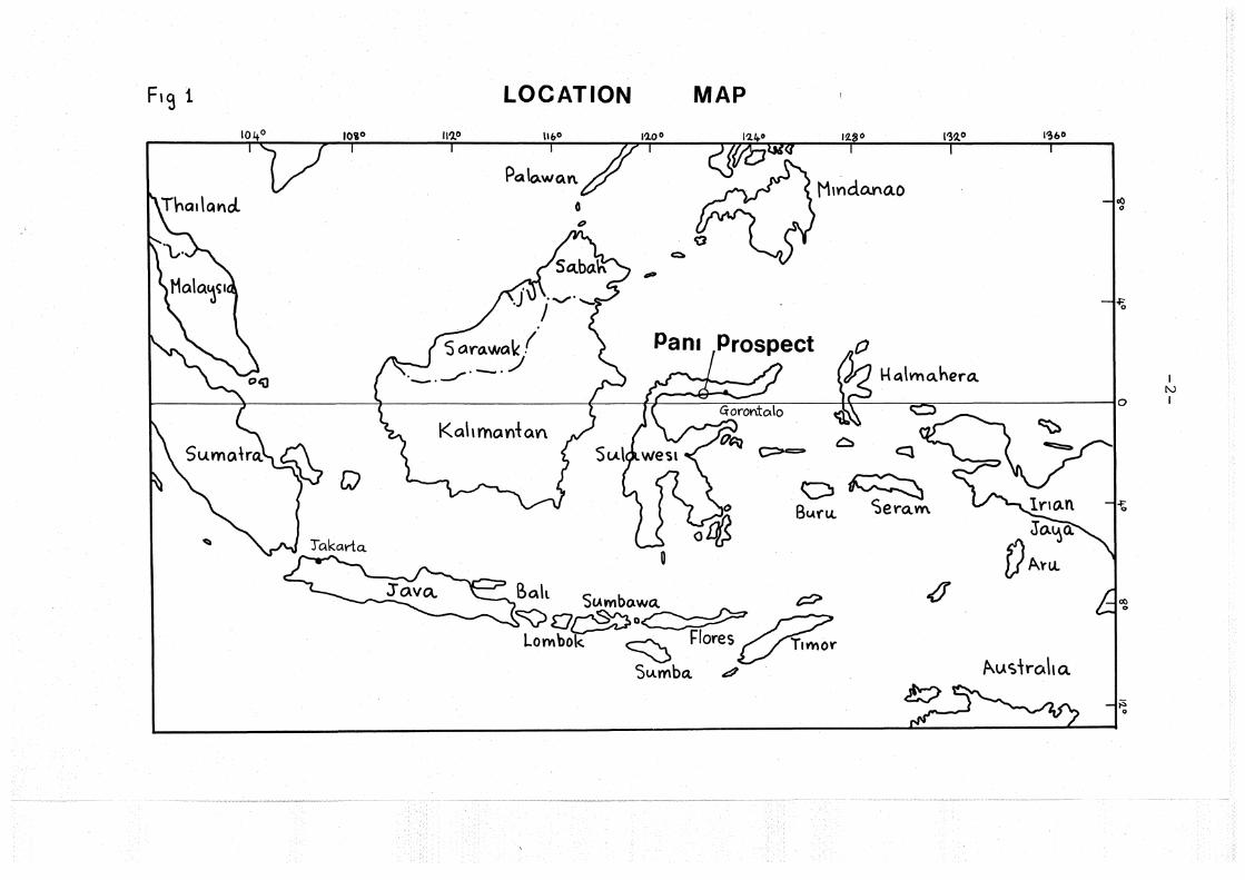
The Gunung Pani gold prospect (Fig. 1) (Photo la,b)
is located at longitude 122°E and latitude 0°33'N, 15km
directly inland from the coastal village of Marisa in the
north arm of the island bf Sulawesi (formerly Celebes).
The nearest large town is Gorontalo, 120km to the east
with airport and harbour facilities. Indonesian internal
air services have flights from Jakarta to Gorontalo daily.
A 160km dry weather road connects Gorontalo to Marisa.
Partly cleared land and villages extend from the coast in
low country to within a few kilometres of the prospect
which is in rugged rainforested topography at an elevation
between 450m and 780m. From the Transit Staging Camp
access is gained by an old track, winding llkm to the
site of the exploration camp at Pani ridge.
F19 1
~
LOCATION
11'10
'5aro.wak ( - . ./
Kah ma.Ylt a.V\
MAP
I .............
0::::.
till»
Pant
~~~0
c:::o~ - <l
0~ Bl..\rt.l Sero..m
<I ~ Q~o Flores T1vr~or Lombok. ~
1~60
c=;> B<>lt S«mbo.~~
Su.mba. .? Z
~
,b-.us'\roha
I l\.)
I


-3-
Photoplate 1 Gunung Pani prospect.
la View of Pani ridge (elevation 600m) from the
northern side of Gunung Baganite (arrow 2b).
Drill site 3 (GPD3) in centre of photo,
drill site 1 (GPDl) on left hand side. The
camp (elevation 425m) is in the deep valley
(Sungai Masina) beyond the ridge.
Valley in immediate foreground is Sungai Pani.
lb View of Gunung Baganite (elevation 780m) ~rom
drillsite 1 on Pani ridge. Contour trenches
at 600, 650 and 700m elevation are faintly seen.
Valley in foreground is Sungai Pani.
i I
I
I I I -I

-4-
In this part of North Sulawesi yearly rainfall
is not particularly high, averaging about 1200mm (Trail
et al., 1974), the wet season being between October and
March.
i The central part of the north arm of Sulawesi
is known as Exploration Block 2 by the Indonesian Mines
Department.
block E.
The Gunung Pani prospect is within sub-
1.3 Scope and aims of this study
From October 1981 to December 1982 the author
was employed by P.T. Tropic Endeavour, Indonesia [wholly
owned by Utah International Inc.] as senior geologist to
geologically investigate and evaluate the Gunung Pani
gold prospect. During the exploration period the
prospect was geologically mapped, extensively channel
sampled and drilled by seven wide spaced exploration
drillholes, totalling 1739m. The deepest hole was
424.20m. In addition, reconnaissance mapping and stream
geochemistry was undertaken for the entire Block E.
The present study, undertaken at the Australian
National University, is a logical extension of the field
programme, and aims to develop an understanding of
genesis of the Gunung Pani mineralisation through
integration of geological, petrographical and geochemical
data.
An underlying theme or broader philosophical
approach pursued during the field investigation and

-5-
recurrent to this work is to consider mineralisation
in terms of the broader geological environment.
Therefore attention is given to description,
petrography and geochemistry of volcanic rocks,
elucidation of the volcanic environment on local and
regional scale, and interpretation of acid volcanic
processes. Hydrothermal alteration and mineralisation
is presented within this framework, followed by ideas
towards a genetic hypothesis of gold mineralisation.
With respect to mineralisation one major
objective was to study the primary occurrence and nature
of the gold.
The research primarily utilised samples from
the diamond core, as well as a selection of rock chips
collected by the author during field mapping.
1.4 Previous work
Gold has been exploited from alluvial deposits
in North Sulawesi at least since the 14th century, at
which time Portuguese built fortifications at coastal
villages and traded in gold (de Neve, 1984). Dutch
mining engineers began to investigate economic mineral
occurrences towards the end of the 19th century.
Fennema commenced work in 1896 but died the following
year (de Neve, 1984). The work was continued by
Koperberg between 1900-1904. Koperberg's work was
published in 1929 in a condensed form after his death
-6-
(Koperberg, 1929). Koperberg's original manuscript,
referred to in old Dutch records, included detailed
geological traverses and up to 3000 mineral occurrences
from North Sulawesi but can no longer be located
(de Neve, 1984). Van Bernrnelen (1949) summarises much
of the geology and mineral occurrences from the earlier
work.
An attempt to exploit the Gunung Pani gold
prospect was made by the Dutch at about the turn of the
century.
The Dutch miners drove a number of adits (up
to 30m) into Pani ridge and extensively pitted the area.
Remains of machinery suggest a limited amount of crushing
and smelting was done, but production is not known.
At around 1910 a dredge operated in the broad river
alluvials at Taluduyunu, and remains of machinery occur
in the river near Transit Camp. Details of this
operation are available in old Dutch records in Bandung,
but have not been referred to by the author.
Tyrwhitt (1969) reported on mineral occurrences
in the north arm of Sulawesi, including the Gunung Pani
Prospect, for Newmont Pty Ltd.
Between 1971-1980, P.T. Tropic Endeavour,
Indonesia, owned and operated by Endeavour Minerals,
explored the Pani prospect area and associated alluvials
by an extensive programme, including geological mapping,
topographical survey and soil and rock chip geochemistry

-7-
on ridge crests and along drainage courses. Gold
mineralisation on Pani ridge and Gunung Baganite was
defined by contour trenching, channel sampling and
re-examination of the old Dutch adits. The alluvial
deposits were tested by several Bangka drilling
programmes and finally by sinking of lm diameter costeans
to bedrock. Despite a lengthy period of investigation,
little progress was made in understanding the geology
and gold mineralisation. The Pani Volcanics (informal
name) were regarded as widely distributed in the Marisa
hinterland, mainly as ridge top cappings. In Sungai
Batudulanga it was recognised that Pani-type igneous
rocks intruded an older basement (Bumbulan Complex of
Trail et al., 1974). Circular structures noted from
side looking radar (SLAR) imagery suggested a volcano-
tectonic control, but this was undefined in terms of
known distribution of the volcanics. At the prospect
itself the imposing summit of Gunung Baganite was
recognised as a possible volcanic neck. The gold
mineralisation was linked strongly to silicification
and argillic alteration, and to quartz veining, the
latter especially at cliff lines around Gunung Baganite.
1.5 Terminology, including use of Indonesian words and names
Usage of geological terminology follows the
AGI Glossary of Geology, and where possible usage is
self explanatory. Certain Indonesian words are used

-8-
referring to place names, including the name of the
prospect, since these names are already entrenched in
previous literature on the area and prospect including
the Indonesian Mines Department records.
Indonesian words in text:
1. gunung - mountain
e.g. Gunung Baganite - Mt. Baganite
2. sungai - stream
e.g. Sungai Pani - Pani stream
The stratigraphic nomenclature for Exploration Block 2
is based on work by Trail et al. (1974). Drillholes
at the Gunung Pani prospect are named GPDl to GPD7
(GP : Gunung Pani; D : drillhole).

-9-
II. REGIONAL GEOLOGY
2.1 Introduction
The north arm of Sulawesi is characterised
by typical island arc volcanic, plutonic and sedimentary
rock assemblages. In a broad sense successive
components become younger to the east along the north
arm of Sulawesi; from pre-Tertiary metamorphic basement
near Palu to Quaternary volcanics and active volcanicity
near Manado, and to the north in the Sangihe Island
Arc chain. It is likely the north arm represents a
Tertiary island arc system analogous to the present
Sangihe Arc (Hamilton, 1979); and in terms of
metallogenesis it can be compared to the Philippine
porphyry copper and gold provinces.
2.2 General
The Tertiary arc system can be described by
three main components (Fig. 2 and Plate 1) : (1) an
early arc submarine basaltic volcanic assemblage;
(2) sub-aerial island arc andesitic volcanics and
granitoids; and (3) the syn-volcanic volcaniclastic
assemblage.
There is evidence of a pre-Tertiary basement
near Palu and at Moutong, composed of amphibolite,
micaschist, gneiss, metamorphosed limestone and granitoids
(Sukamto, 1973; Ratman, 1976).

Fig-. 2
I.K. D
-10-
Main tectonic elements and igneous rock assemblag-es of Sulawesi
1'22.0
CELEBES
11.1,.• % San91h.e~ Is.
t.
$ ,
Palaeozoic continental fragment
LEGEND
Gl] Bas1c- andec;,t,c volca"IC
Bas~t- oe~cl volcatucs ~ qra.n1i:ouis.
~ Opl'uol•tes
Basement
G. G.u.aterno.r~ T Terbo.r'i l"l Pre- Te~t•ar~ or N~o1.o1c
Volca.no (a.c:tiVe\ * X Volca.no
Q. ~mer~&"-\ COA\+ llt~e (.for c:emra\ of N. cn·WW\)

-11-
The Tinornbo Fm (Sukamto, 1973; Ratman, 1976;
Trail et al., 1974) represents an early arc volcanic
assemblage of probable Eocene age and is composed of
phyllite, slate, red chert overlying basic lavas and
agglomerates, including pillow lavas. The Tinornbo Fm
is overlain by the Bilungala Volcanics (the sub-aerial
andesitic arc) and a wide apron of volcaniclastics
derived from the growing Bilungala Arc (Plate 1).
The Miocene Bilungala Volcanics (Trail et al.,
1974) are composed mainly of andesitic volcanics, minor
basalt and rhyolite and are interbedded or grade
laterally into sequences of graywacke with minor limestone.
The volcaniclastics belong to the Dolokapa Fm (Trail et al.,
1974) which were deposited synchronously with the emergent
volcanic arc. The Bilungala Volcanics are intruded by
granodiorites and quartz diorites with associated gold
rich porphyry copper mineralisation east of Gorontalo,
in the Tornbulilato district.
The Miocene Bilungala Arc is considerably
eroded, as is evident from the large area of exposed
granitoids. A great deal of the detritus has been
deposited in the Gulf of Gorontalo, which is 2000 metres
deep, but contains in addition 5000 metres of Quaternary
sediment, and in the Sulawesi Sea, into the North
Sulawesi Trench, where 2000 metres of sediment occurs
in water depth up to 5000 metres (Hamilton, 1979, Plate 1).
Coarse fanglomerates of Bilungala Volcanic detritus
(Quaternary and possibly Recent) with interbedded coral

-12-
reef lenses fringe parts of the coastline.
At least in the central part of the north arm,
renewed volcanic activity occurred during Plio
Pleistocene time, producing widespread acid and
intermediate pyroclastics (Wobudo Breccia) along the
northern part, and basic to acid pyroclastics along
parallel rifts (Pinogu Volcanics) . Descriptions by
Trail et al. (1974) and Tropic Endeavour geologists
(pers. comm.) suggest the Pinogu Volcanics may be a
bimodal acid-basic volcanic suite.
In North Sulawesi the Miocene Bilungala
Vo.lcanics or their equivalents are overlain by Quaternary
and active andesitic stratovolcanoes that form the
southern extension of the Sangihe Arc (Morrice et al.,
19 83) .
2.3 Marisa area
2.3.1 General
The Marisa hinterland is dominated regionally
by basaltic rocks belonging to the Tinombo Fm (Plate 1) .
Along the coast and in the area of the Gunung
Pani prospect metadolerites and amphibolites intruded
by granitoids are found. It is not clear how these
rocks are related to the Tinombo Fm, but it is possible
that at least the amphibolites represent older basement.
Based on Trail's et al. (1974) mapped distribution of
amphibolite an area of older basement is tentatively
shown on Plate 1.

-13-
The granitoid-amphibolite basement is extensively
intruded by dolerite dykes that may belong to the Tinombo
Frn basaltic volcanism.
The Gunung Pani gold prospect occurs in younger
acid volcanic rocks (Plio-Pleistocene?) , referred to as
the Pani Volcanic Complex. Distinctive lithology and
large scale circular structure of the Pani Complex
relates it to several other similar volcano-tectonic
structures, which are unexplored or only cursorily
examined. The Tabulo structure (Photo 2) , 18km to the
SE, is a ring-dyke complex, 3km in diameter, intruded
into the metabasic and granitoid basement, where erosion
has entirely removed the volcanic superstructure.
Unlike the Pani Complex, no gold is associated with the
Tabulo structure. The Molango structure (Plate 1)
35km NW of the Pani Complex, is poorly known, but is a
circular feature shown by Trail et al. (1974) to be
partly composed of Pani volcanic rocks, and of similar
size. An old gold working is shown located near or
in this structure.
As well as major volcano-tectonic structures,
there are many smaller circular structures, some
superimposed and nested in larger features (Photo 2) ,
widely distributed along the coast from Tilamuta to west
of Marisa, but due to only poor SLAR imagery available
to the author these features have not been interpreted
in detail. They are the remnants of an extensive
intermediate-acid volcanic field, generally eroded to

Photoplate 2
-14-
SLAR imagery of the Tabulo r~ng-dyke Complex and interpretation
INTERPRETATION
0
C 1rcu lar strL\dure / Road
L1nea ments Samples

-15-
subvolcanic levels. This volcanic field is referred
to as the Pani Volcanics.
From the sparse data it is suggested that the
volcano-tectonic structures occur in a linear ESE to
E-W trend, comparable with major tectonic elements of
this part of North Sulawesi.
In the Pani Volcanic Complex the youngest
intrusives and pyroclastics are distinctive, due to
lack of hydrothermal alteration and resemble lithologies
mapped elsewhere as Pinogu Volcanics. They also bear
remarkable similarity to a single specimen collected
from Una-Una, which is an active volcanic island 60km
SW of Marisa (Fig. 2). The Una-Una volcanics are
mineralogically unusual, due to the conspicuous presence
of biotite (Neumann van Padang, 1951; Katili et al.,
196 3) .
2.3.2 Granitoids
2.3.2.1 Medium-grained hornblende-biotite granodiorite
Basement granodiorites occur from Marisa east
to Tilamuta and in the vicinity of the Gunung Pani
prospect, but their size, distribution and field
relationships are poorly known. The granodiorites
are medium-grained, equigranular or coarsely foliated
and appear to have complex interfingering relationships
with amphibolites. These textures are typical of a
high-grade metamorphic, and in part migmatite terrain.
-16-
Outcrops of these granitoids near the Gunung Pani
prospect consist of up to 50% quartz; 40% sodic
plagioclase and 8% ferromagnesian minerals, mainly
hornblende, and 2% opaques. The ferromagnesian
minerals are highly altered, replaced by chlorite
and epidote; epidote entirely pseudomorphing hornblende.
K-feldspar content is very low and commonly not detected
by sodium-cobaltinitrite staining. It is possible
that in highly altered specimens quartz has replaced
primary mineralogy. Relatively unaltered, texturally
similar hornblende-biotite granodiorites occur in the
left hand branch of Sungai Batudulanga (e.g. 8397) and
consist of approximately 30% quartz, 15% hornblende and
biotite and 50% sodic plagioclase. K-feldspar content,
as revealed by sodium-cobaltinitrite staining, is a
few percent or less. A chemical analysis of sample
IKS2J_,collected near the prospect, supports a very low
K20 content.
The petrography, chemistry (Table 1) and
geological setting is consistent with an interpretation
that these are low K-granitoids and may have formed in
an oceanic crustal environment but better data is
required to test this tentative hypothesis.
2.3.2.2 Foliated microgranodiorite
Associated with the low K-granitoid-amphibolite
terrain is a large area of fine-grained foliated
biotite-hornblende granodiorite. The Pani Volcanic

-17-
Table 1 Geochemistry of the basement granitoids
IKS 8 IKS 21
Sio2 66.50 73.10 Ti02 0.44 0.32 Al203 16.25 13.10 Fe2o 3 2.12 1.19 FeO o. 98 0.90 MnO 0.04. 0.04 MgO 1.40 0.85 cao 3.98 2.27 Na20 3.77 4. 72 K20 2.88 0.86 P205 0.08 0.01 s 0.09 H2o+ 0.92 1.17 H20- · 0.20 0. 27 C02 0.22 0.75 Total 99.97 99.72
Ba 750 130 Rb 82 31 Sr 462 216 Pb 29 20 Zr 111 116 Nb 6.5 1.0 y 12 35 La 21 7 Ce 44 17 v 27 27 Cr 6 Ni 3 Cu 3 5 Zn 43 29
K/Rb 292 230 Rb/Sr 0.17 0.14 K/Ba 32 55 Sr/Ba 0.62 1.66
IKS 8 Foliated microgranodiorite Location : Sungai Batudu1anga
IKS 21 Low K-grani toid Location: Transit Camp

-18-
Complex intrudes mainly the foliated microgranodiorite
on its N side, while to the SW the adjacent basement
is composed of low K-granitoid. The low K-granitoid
basement is intensively intruded by dolerite dykes
(Tinornbo Fm age?) , while in the foliated microgranodiorite
dolerite dykes are rare or absent. Amphibolite
xenoliths which are spatially and perhaps temporally
related to the low K-granitoid are common in the foliated
microgranodiorite. These relationships suggest the
foliated microgranodiorite is younger than the low
K-granitoid-amphibolite basement and possibly postdates
the Tinornbo Fm. Chemically the foliated microgranodiorite
is typical of continental calc-alkaline igneous rocks
(Table 1) , and not unlike the Pani Volcanics (refer
to section 4.5.1).
The foliated microgranodiorite is composed
of 60% plagioclase, 25% quartz and 5-10% biotite and
hornblende in varying proportion, and 2% opaques (magnetite).
Plagioclase is strongly zoned, euhedral and occasional
larger crystals give a porphyritic appearance. • The
enclosing fabic is strongly oriented and envelops the
plagioclase crystals (Photo 3a) . Quartz is strained,
interlocking and forms a metamorphic foliation with
oriented crystals and clots of ferromangesian minerals.
K-feldspar is mainly anhedral and interstitial.
The foliated granodiorite is texturally
incompatible with high level intrusion, but consistent
with deep level granitoid emplacement and high pressures.

-19-
2.3.3 Amphibolites
Amphibolites are typically medium-grained,
equigranular or coarsely foliated and composed of;
50% hornblende, 35% plagioclase, 10% interstitial
quartz and 5% disseminated opaques. A few specimens
are composed almost entirely of coarse intragranular
aggregates of hornblende.
Apart from an association with low K-granitoids,
structural and field relationships are poorly known.
2.3.4 Tinornbo Fm basalts
From the work by Trail et al. (1974) much of
the Marisa hinterland is composed of basalts, including
pillow lavas, dykes and minor pelagic sediments. The
Tinornbo Fm is thought to be of Eocene age (Trail et al.,
1974) and unmetamorphosed or metamorphosed to lower
greenschist facies grade (Photo 3b) .
The higher ranges inland from Marisa around
Gunung Paal Dua are composed of a thick sequence (>500m)
of shallow dipping (S to SE) basaltic lavas and minor ,
basic pyroclastics, intruded by dolerite dykes.
Dolerite and basalt dykes are common everywhere. Near
the summit of Gunung Paal Dua (elevation 1500m) the
basaltic sequence is overlain by thin beds of red
pelagic siltstones containing planktonic foraminifera
(K.A.W. Campbell, pers. cornrn.), followed by a sequence
of acid volcanics.

-20-
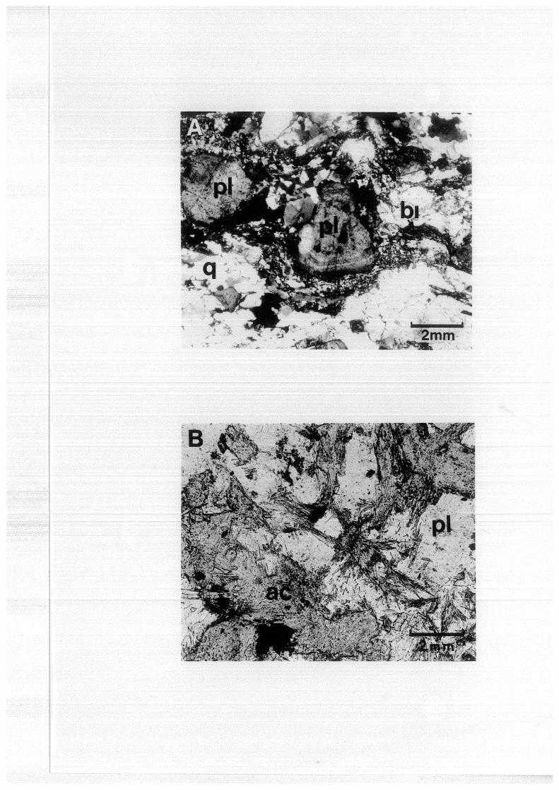
Photoplate 3 Foliated microgranodiorite and metadolerite
3a Foliated microgranodiorite.
Zoned plagioclase phenocrysts in a foliated matrix
of interlocking quartz and biotite. Coarser
aggregates of quartz with interlocking boundaries
enclose the mafic-rich layers. Quartz crystals
are mechanically strained (top right) .
X-nicols.
3b Metadolerite.
Acicular actinolite replacing former ferromagnesian
minerals, 50%; plagioclase and minor quartz (not
shown) .
x-nicols.
Symbols
q : quartz; pl plagioclase; bi biotite;
ac : actinolite.

-21-
2.3.5 Pinogu Volcanics
At Marisa and to the west outcrop fresh
unaltered porphyritic basalts and basaltic breccias
of unknown distribution. SLAR imagery suggests
volcanic morphologies such as small volcanic cones and
craters are preserved. These rocks are correlated to
the Pinogu Volcanics which are best known in the Lirnboto
Depression, and east of Gorontalo in the S. Bone valley.
2.3.6 Una-Una Volcano
A single specimen from an unknown locality
from the Una-Una volcanic island consists of 40%
plagioclase, 7% biotite and 5% hornblende phenocrysts
(l-2mm), in a dark microcrystalline opaque-rich
siliceous matrix. The plagioclase is strongly zoned,
and commonly contains inclusions of biotite and apatite
needles. Phenocrysts are moderately flow oriented
and the specimen evidently represents an andesitic lava
flow.
2.4 Plate tectonic interpretations
It is well recognised in the literature that
the Island of Sulawesi (Fig. 2) comprises structurally
two different igneous assemblages and perhaps tectonic
terrains(l); the eastern arc of Tertiary mafic and
ultra-mafic rocks, including amphibolite, greenschist
(1) in the sense of 'suspect terrains', Coney et al. (1980).

-22-
and glaucophane-lawsonite metamorphics; and the
western arc of (?)pre-Cretaceous metasedimentary
basement and largely unmetamorphosed, Neogene basic to
acid volcanics and granitoids (Brouwer, 1947;
Sukamto, 1975; Katili, 1978; Hamilton, 1979). Katili
(1978) has drawn an analogy to the paired metamorphic
belt concept of Myashiro (1961).
The tectonic evolution of Sulawesi is subject
to considerable debate.
Katili (1978) envisaged a north-south trending
and east facing Tertiary arc-trench system originating
well east of present day Kalimantan and the Asian
continental margin, and colliding, first with the
Australian-New Guinea continental margin in early Pliocene,
producing severe deformation and obduction of ophiolite
(the eastern arc), followed by movement westward and
final collision with Kalimantan (Asian continental
margin). The latter event resulted in emplacement
of ophiolite in the Meratus Mountains of Kalimantan.
Finally Sulawesi rifted from the Asian continent during
a Quaternary opening of the Makassar Strait.
Other scenarios (Hamilton, 1979; Otofuji et al.,
1981), and perhaps more realistic in the author's view,
envisage that the western arc developed in the vicinity
of the Asian continental margin and was perhaps similar
to the present day Sangihe Arc, and by Early Tertiary
time had become part of Kalimantan, but then was
separated by rifting (Makassar Strait) during the Pliocene.

-23-
Hamilton (1979) interprets the geology of
both the west and east arcs to record eastward migration
of a west dipping subduction system during Cenozoic
time and tectonic accretion of material, culminating
with imbricated tectonic complexes and emplacement of
the Sulawesi Ophiolite Belt in Eastern Sulawesi due to
Miocene collision with westward drifting continental
fragments (Buton and Sula). (See also Silver et al.,
1983a). Otofuji et al. (1981) consider the eastern
arc has affinities with Mesozoic sedimentary successions
in the Banda Arc, Timor, Ceram and with parts of
Australia, and with westward drift and collision it
became part of western Sulawesi during Miocene time.
They, as well as Silver et al. (1983b), postulate the
Miocene collision and obduction may have resulted in
the oroclinal folding of the northern arm of the western
arc. Hamilton (1979) regards the oroclinal bending of
the north arm to be mainly of Quaternary age related to
sinistral movement on the Palu Fault coupled with active
subduction in the North Sulawesi and Sangihe Trench
systems.
A Miocene to Recent tectonic evolution of
Sulawesi, based mainly on the work by Hamilton, is
shown in Fig. 3.

-24-
M1ocene - Recent tedomc evolubon of SulawesL
A
a.rc D AUSTRA.LIANNEW ~UINtA. \ PLA.TE /
(A) Westward cArttt1nq Cont~nental tragment detached {rom the Australtan -New Gutneo.. Plofethe Sula spur.
(C) North Sulawesi subcludton lnltH:ded.. Oeformahon conttnues- clockwtse rofahon of tl-1e N. E.. orm.
N1ocene -Phoce.ne bounc:Aa.r'1 S" m11 ~qo
c
Obducted Oceontc
* crust
t] Contme.ntal ~ ' - m 1cro-conhrte.nt.
I 1\dtve subdudton ij1 z.one
I Thrt.~si fault
(B) The Su\o.. spur collides wtfh +he west Su\awes1 arc. Obduchon o{ Oceqntc crusti deformatton of forme.r N-5 arc.
(o) Extenstonal rtHtn'3. Sdtclc 4 bac;;tc vo\camc ad 1vd l1 (Pant Vokontc s).
Present
VolcClnlc cham
bdenstonal r1 f+tY"Ig
Plate mohon.
Not to scale IK A.pr1\ S'3.

-25-
2. 5 Dis cuss ion
The occurrence of red pelagic siltstones with
planktonic foraminifera at Gunung Paal Dua is evidence
for a deep water environment, and suggests that at
least till the (?) Miocene emergence of the Bilungala
Arc the area was submerged and comprised ocean floor
with water depths in excess of 200m. The Tinombo Fm
is interpreted to represent an early-arc assemblage,
possibly with geochemical affinity to island arc
tholeiites (Jakes and White, 1972).
The basic volcanic and clastic assemblage of
the Tinombo Fm would be analogous to the present day
submarine facies of the Sangihe Arc. This interpret
ation of the Tinombo Fm differs slightly from that by
Trail et al. (1974) who consider it to be an ocean
basalt assemblage, rather than specifically the base
of an island arc.
The acid volcanics on Gunung Paal Dua may be
related to the Bilungala Volcanics, outcropping lOOkm
to the east.
The relationship between the Tinombo Fm and
the metadolerites and amphibolites is uncertain as
apart from metamorphic grade they differ little. One
possibility is that the amphibolites are simply meta
morphosed Tinombo Fm basalts, due to granitoid intrusion
in which case basement of a pre-Tinombo Fm age does not
necessarily occur in the area. Alternatively the
association of low K-granitoids and amphibolites may
be interpreted as the root zone of a former Oceanic
Island Arc.

-26-
Disposition of the major geological units,
major faults and morphology define a structural grain
parallel with the E-W trend of the north arm and
discordant ESE. The Limboto Depression, near
Gorontalo, one of a number of such features, is the
expression of extensional rifting with associated
basaltic volcanicity (Plio-Pleistocene Pinogu Volcanics).
This volcanic activity may be due to back arc
rifting related to the active North Sulawesi Trench
system. This interpretation would be consistent with
the suggestion that the Pinogu Volcanics are a bimodal
acid-basic volcanic suite.
The Pani Volcanics can similarly be expected
to be controlled by extensional tectonics, but the
control is not obvious.
Recognition of the broad island arc character
of the north arm with progressive younging to the NE
raises the question how extensive the underlying older
pre-Tertiary cratonised basement is, which probably
occurs near Palu. A compilation of the distribution
of pre-Tertiary continental crust in Indonesia by
Hamilton (1979) is shown in Fig. 4, and suggests at
least the western part of the north arm may be underlain
by older basement, but probably not extending as far
as the Bilungala Arc andesite volcanic pile.

F,9 1+
DISTRIBUTION IN
1100
-27-
OF PRE TERTIARY CONTINENTAL CRUST SOUTH EAST INDONESIA
115° 130°
Q
~o~
0
Adapted. from Homdton ( 1q1q)
.Pre Tert1ary Continental Crust

-28-
The broad pattern of the north arm and
relationships to the Western Sulawesi Arc, and north
to the Sangihe Arc, suggests that crustal evolution
along island arc chains, as well as parallel, may be
a sequential and long lived process, currently poorly
understood.