the geology - resources.bgs.ac.uk
TRANSCRIPT

~A ~
SOUTH WEST AFRICA!-___ _
DEPARTMENT OF MINES
Memoir No. I --.~-.---~
THE GEOLOGY OF THE
WESTERN REHOBOTH , .. ~-.
Published by authority of His Honour the Administrator
Price 10/6 (including Map) (Copyright)
PRINTED BY JOHN ME/NERT LTD" WINDHOEK 1931

CONTENTS.
CHAPTER.
1. Introductory
n. Physical Geography. 1) Morphological features 2) Roads 3) General 4) H ydrograI'Jiy 5) Rainfall 6) Springs 7) Vegetation 8) Soils
Ill, List of Geological Formations,
IV., General Geology and Structure,
PAGE.
5
6 7 8 9
10 11 11 12
13
Historical . 14 General Geology 14 Tectonics . 15
1. PoslPNama Faults .. . 15 n. Faults of Doutful Age - Probably Pr.-Nama 16
Ill, F,1ults of Undoubted Pr.-Nama Age 17 Sket,1,. of the Geological History . 17
V, l're·Damara Beds, A. Marknhof Series 20
The Phyllites . 21 The Quartzites 21
B. Th" Duruchaus Series. . . .. 22 (,1) The Blot!t<>, Musoovite and Sericite Scrusts
wlih Impure Llmesbone Bands, ete.. 26 (b) Th" Crysl,11lIn" and Taloose Marbles. 31 (c) The Mic.1COOUS Quartzites . 33
VI. The D,1mara System. A. The Quartzite Series. B. The Marble Series C. 111,e Tillite D. The Khomas Series
VII, The Nama System. A. Basal Beds . B, Th'e Schwarzkalk Series C. The Schwarzrand Series
(a) Lower SJia!es . (b) Quartzites . (c) Upper SJiales .
- 1
37 41 44 45
52 59 64 64 65 65
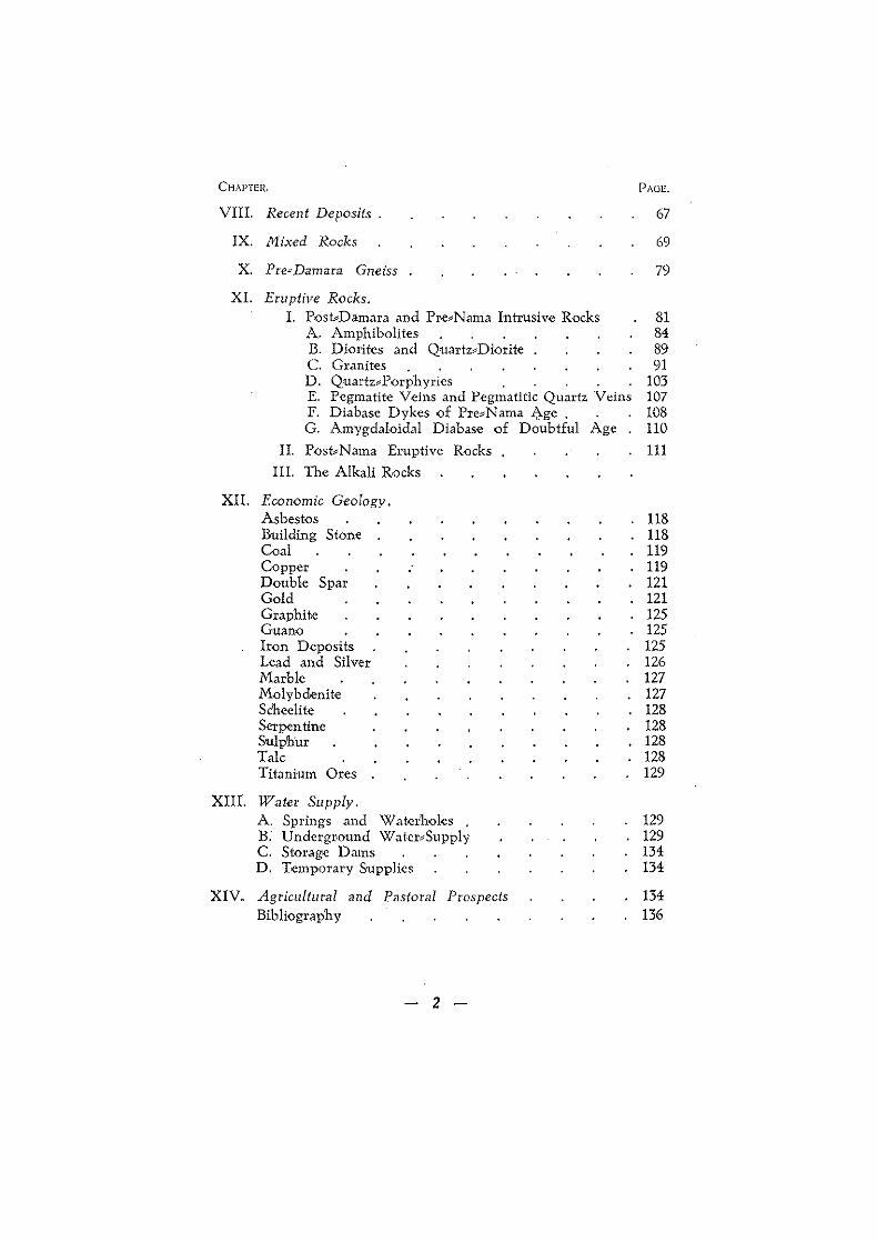
CHAPTEH.
VIII. Recent Deposits.
IX. Mixed Rocks
X. Pre=Damara Gneiss
Xl. Eruptive Rocks.
PAGE.
67
69
79
I. Post.Damara and Pre,Nama Intrusive Rocks 81 A. Amphibolites 84 B. Diorites and Quartz,Diorite 89 C. Granites 91 D. QuartuPorphyrics 103 E. Pegmatite Veins and Pegmatitic Quartz Veins 107 F. Diabase Dykes of Pre,Nama J:>.ge . 108 G. Amygdaloidal Diabase of Doubtful Age 110
II. Post,Nama Eruptive Rocks 111 Ill. The Alkali Rocks
XII. Economic Geology. Asbestos Building Stone Coal Copper Double Spar Gold Graphite Guano Iron Deposits Lead and Silver Marble Molybdenite Scheelite Serpentine Sulphur Talc Titanium Ores
XIIt. WaleI' Supply. A. Springs and Wa!crholes B. Undergr.ound Watcr"Supply C. Storage Dams D. Temporary Supplies
XIV. Agricultural and Pastoral Prospects Bibliography
- 2 -
118 118 119 119 121 121 125 125 125 126 127 127 128 128 128 128 129
129 129 134 134
134 136

CHAPTER 1.
INTRODUCTORY. Ar~u.
The sheet undcr description is bounded on the south and north hy the 21' al1d 23" p,1l'allcls of S. latitude respectively while the 16" And IT' meridians .of E, longitude form its western and eastern IIm118, It IhllOooml'riSl" ,111 entire degree sheet with an area of (,130,9JJ 1I~cli\I'''8 (1.166.5 .q,mlles). Except for a small portion 41f III~ IHJI'lh'W<l81<l"11 ,~))'I\er which falls in the Windhoek district tllo ~1It11'\! ~l'<lA lie! In the Reho[,oth district and roughly one half 1I n,l~t"r Cl@bl.,t wllkh Is a semi,reserve occupied by the Basters (oololtl'\!lb) llrl()r to the German settlement of 1885.
l"1lu.I lU'cn except in the extreme western desert portion is, for Soutll West, well populated by pastoral farmers. The grazing is p;oou ,111d climatic conditions favourable, while stock disease, apart from horse,sickness, is practically unknown.
The smvcy was dOl1e on field sheets provided by the Surveyor G-ctl(!r.il's offioc and these were compiled from the available tope:::: IIrnp'h1c.1I d.ll. such as farm surveys, the geological map of E. Rh1ll1llll. etc. Por Ih. llorthl>eastern arca two 20' field slleets of the O('!I'IllM\ t,opoA'J'ilphlcal survey were available. These two sheets are Alm<l!! perfect III every t{)pograp'hical detail, and are on the scale of 1: 100,000. AllhOugh this seems " largc scale for gwlogical work, .Ilt! i, III fact too I.ll'ge for fh~ simpler areas, it is by ~) mCJ\t\M ll\l'iIC cno\lglh fot' the VC1'Y complicated north::eastern corner Alld AI.o the middle e.l.t, where the oomplex folding and faulting jlUnbl~d A 1I111hly .Ikl'"d .,semblagc {)f rocks of different ages tK,~t1I~r,
l'rcl'/<lIlS W' ork. 1'h" first known reference to the geology of this area is by
Stnpff (1)', Gurkh (2), Dr. E. Stmmer VOn Reichenbach (3). In 1904 Volt and Stollreither mention the area of tile lower Kuiscb valley and the Gansberg (4).
In 1910 and 1911 Dr. E. Rimann made a geological survey of the Baster Gcbiet f{)r the Hanseatische Minell_Gesellschaft (D.K.G). His map together witH an explanation was published hi 1915 (5). A short paper by the same author ancnt the alkali rocks {)f the Baster Gebiet appeared in 1914 (6) .
• Numbers in brackets refer to the list of literature references given at the back.
- 5 -

In 1916 Wagner's memoir on the Geology and Mineral Industry of S.W.A. was published, in which are references to this area (7).
Reuning in 1923 published his. geological map of the middle South West, accompanied by a short paper (8).
In 1925 Reuning's description of the Natas mine <1ccompanied by a geological map of the surrounding area, comprising just over one 20' field sheet, was published (9).
These, with the exception of Rimann's work, are all very brief and not very helpful for the purpose of detailed mapping and study. Rimann's work on the Baster Gebiet was very hurriedly done, and in consequence suffers in accuracy. This is especially true of his tectonic interpretations which in many places cannot be reconciled with the evidence of more detailed mapping.
The author has freely used the above works wherever possible~ but the survey and oonc1usions arc entirely his own.
The survey took two field seasons, 1930-31, of approximately 41/2 and 5 months respectively.
The work was prolonged by the complex nature of the north" eastern section, and the inaccessibility of the western desert section lying below fhe escarpment, which in places is an arid desert for hundreds of sq.miles where neither man nor beast can live for long. This inaccessibilty was further accentuated by the prevalence of horse_sickness in the low veld and desert during the rain months, making animal transport impossible when water and grass can be obtained.
CH APT E R 11.
PHYSICAL GEOGRAPHY. The area under desCTiption is one of geological, structural,
topographical and scenical contrasts. Some of the finest desert and mountain scenery can be witnessed from the heights of the Imposing Gansberg, while the endless rolling chain of undulating hills that can be seen from the escarpment at Us westward along the Kuiseb valley reminds one of the "Valley of a Thousand Hills" in Natal, in a different setting.
(1) MORPHOLOGICAL FEATURES. The area as a whole presents marked topographical features,
for whereas the greater part belongs to the highveld and lies above the 1500 m. (4920 ft.) contour the western strip below the escarp_ ment already falls within the scope of the coastal plains or Namib desert. The escarpment is' very marked, so much: so that in the whole area under description there is only one descent at ,Us that can be undertaken with a vehicle, and that is partly out of the sheet. Bridle paths arC few and far between, and even descent on foot is not always possible.
6

The most marked physical feature of this area is the Gr. Gans, \l!'l'1I (Gans - Nama, meaning high plateau), 2332 m., the Table Mmll'ltain of South West. For sheer flatness it is even more like a IlIble than Table Mountain. On the western side there is a fall of 1332 m. (4,370 ft.) in 22 km. (l31/z miles) to the valley of the Gau\) !'lWI', 1000 m.
"lnselberge" are common on the plateau or highveld, the most prominent -of these being the quartzite mountains of Charlotten.<' bCl'g and Marienhof, (Plate I, 1 and 2) and the phonolite,capped Duruchas hill, Plate XIII. The tors of typical' woolsacbweathering granite are grouped together, while the massive quartuporphyries ()f the Nuckkopf range weather in steps and bastions, forming im, posing mountain chains.
Table of Altitudes. These arc taken from our maps and German diagrams; aneroid
checking was attempted wherever possible, but this was not success", ful owing to the poor class of instrument available:-
Great Gansberg . Alberta Mt.
Charlottenberg Kristallgestein Zwischenpunkt A. Steinfeld Nuckkop£ Swartfontein, near
fountain Biedersfarmberg Tsebriseb Mt. Ninais beacon Luderitzberg Tantusspitze Arnamberg Marierihof Mt.
(Chilkopf) Meilenrucken Rote Kuppe Schafweidcn Nebenpunkt B. GUrumanas berg Hohe Kante
(2) ROADS.
Metres. 2332 2221 2144 2090 2059 2049 2028
2006 1994 1974 1963 1958 1939 1931
1892 1885 1882 1871 1834 1826 1804
Noasfelsen Nukurus N auchas police stn. Garis trig. beacon Duruchaus Sp i tzkop Kosspitzc Aroams homestead Kobus homestead Doppelkopf Achaub trig. beacon Komasis homestead N auzerus homestead Narebis homestead AbendrDth trig. beacon Natas mine Us berg Eisgaubib homestead Chausib wed Ubib waterhole Chaibis spring Lower Kuisib Valley Lower Gaub Valley
Metres. 1784 1775 1750 1720 1715 1634 1630 1612 1602 1583 1562 1551 1526 1452 1402 1362 1142 1090 1084 1042 989 980
The main roads are marked on the map. These are mostly bad and communication in and over the area is in consequence much hnmpered. Th'c sandy valleys and flats have the best roads, while the schists, especially of the Khornas Series, are on account of the irregular wear and abundance ()f quartz rubble the worst. The
7

Basters have numerous roads radiating from each "werf", and it is often impossible to travel from place to place without a reliable guide. As already stated the low veld or Namib section is without any road whatsoever, except the Us-Donkersan road which is hardly traversable by car beyond Eisgaubib.
(3) GENERAL. To the north lies the Khomas highland, an almost endless
stretch of schist hills which slope to the north, the dip side, and are more or less sharply terminated to the south. In the stretch north· and east of the Hakos mountains where the Gomab river has serrated the schists in sharp ridges with deep rugged kloofs the local farmers call it "Gramadulas", a collective name for difficult coUlltry. This name also applies to the section between the Gans> berg and the Hakos mountains and to the valley of the Gaub.
The Khomas highland is terminated by the steep and rugged moun.t~1il1S which are formed of a pitching anticline of qua.rtzites
. standing up from underneath the schists. To the east there is the range of quarhi1cs ano marbles forming the Ninais mountain, Char>'" lottenberg and Arnam berg range, while further east on the bound~ ary of the map ar~ the typical ' inselberge' of phonolite with the Duruchaus Spitz.kop the most prominent.
The TSf,briseb mountains rise some 400 m. above the surroun~ ing flat country, due mainly to a very str·ong fault line since utilised by the western tributary of the Twee river. The country around Niarienhof is flat, with in places 'inselberge', such as the white Maricnh"f quartzite mountain and some of the more prominent black amphibolite 'koppies'. (Plate II, 1 and 2.)
Irom Marienhof to Hoornkranz and Gamsberg the country is flat and grass~coV<'reJ with only occasional low hills breaking the monotony. On Gamsberg (or Groendoorn) is situated the Gans~ berg referred to above, the most prominent of th'c eminences of this 'rea. Immediately to the north of Gansberg lies the deeply incised valley of the Djab a tributary of the Kuiseb river. To the south and west lie the valley of the Gaub, and where the latter leaves the map the lowest altitud~ is recorded. South of Hoornkranz and the Gaub lies the massive block of red granite stretching beyond Kobus and Morgenrot'h:, tors and ramparts of solid rock tailing off into round hillocks and 'koppies' to the north. On Areb and Alberta lie the massive brown~black ridges of amphibolite and diabase rising to 2221 m. in the Alberta mountains, the \second highest point 011 the map. U~shaped valleys lie between the various ridges.
The oountry round Nauchas, Borodino, Namibgrens, Swart"" fontein and Namakorabis is largely highveld flats with granite ridges, tors and hillocks as far as the escarpment. In the im~ mediate neighbourhood of the escarpment there is an abundance of narrow dykes of diabase, which stand out from the light coloured granites of this area as so many black ridges weath<ring in piles of round boulders. (Plate X.)
8 -

Below the escarpment at Swartfontein lie the endless stretches of Namib sand and deflation residue, usually covered with waving white grass and teeming with game. These sand £lats sweep round with the escarpment to Koire:b and Ababis and cover about 800 square miles of waterless desert country.
The country south of Marienhof shows typical granite scenery, round smooth~faced krantzes and occasional tors with typical wool~ M.\ck"wcathcring in places. This granite massif extends to Groen'" drani on the eastern boundary and from there through Grundorn And Homcib to Noatis wher·e its place is taken by the quartz~ pOl'l'hyl'ics of th<: Nuckkopf range. To the south of this granit~ the youngcl' scdim-cnt.lrics of the Nama extend in vast rolling grass,," \X)vel'cd IlIain. fl'<lIll which wcll".,arked flat dark ridges of Schwarz~ kAlk Ihlle.IOlwN And Schwar"'AI"! qua,'ltites stand out with shelving VAl1~y" of mlldIIOIl"' In hetween.
WeslwAk'U ft'l\m RUK,kttu,' t'lux>ugh Garis, Nauzerus and Noab th@ Si!llwM,.kAlk 11IAtMu I. A 1",)["lnent feature terminated in the 811\llb AIIAI1I81 th~ MAllahohc plains by the strong faulting of the 11111181)1)1)1'1 lill", '1'" the west the plateau ends in outliners of lime; .101\0 And grit, on the Steinfeld range and the mountains round AbAhl. where it forms the escarpment from the highveld to the NAllllb.
(1) IiY DROGRAPHY.
There are no perennial streams in this area, and for the greater pal'! IllOS! of them flow for only a few hours, or at most a few d"ys after heavy showers.
The river courses drain into two large rivers; (l) the Kuiseb;. Which eventually reaches the Atlantic Ocean at. Walvis Bay, and (2) the Orange via the Fish river. Then there is the Tsondap which must once have reached the Atlantic somewhere near the present Conception Bay, but is now entirely dammed by the dune belt of fhe west wast and forms a large drowned vley.
The western or Kuiseb drainage system consists of the follow",: ing rivers;- The Gomab draining the area immediately north and east of the Hakos mountains and flowing into the Kuiseb at Eisgaubib. The Djab draining the area between the Hakos and the Gansberg with the Obus and the Natas rivers draining the western slopes of the Hakos anticline, all three separately joining the Kuiseb. The Chauchab rising on the western and north~western slopes .,f Gansberg passes through Chausib and flows into the Kuiseb. Further to the south the country from Isabis, Areb, Alberta and Weener is drained by numerous tributaries of the Gaub which in its upper reaches has a steep gradient. The numerous amphibolite dykes and the harder quartzite bands which it traverses form numbers of good waterholes.
Th'e country round Swartfontein and Namibgrens is drained by the numerous rivulets which eventually j-oin the Ubib river, another tributary of the Kuiseh.
9 -

The Tsondap river mentioned above has its origin in the mountains between Noab and Nauzerus and is joined at Ab,1bis by tributaries from Zais in the south and Namakorabis to the north. It flows through a bed of Iime.cemented boulders and sand, cover<:d schists leaving the area north of Swartkop.
The sO'uth::,eastern or Fish river system rises on the water::' shed which runs roughly diagonally across the sheet from the north::<east corner to somewhere south of Nauzerus near the south::: west corner of the sheet.
In the extreme north:::east corner the rivers of Krumneck and Gurumanas which oombine at Quaggas drain the country, to' be joined soutbeast of the Charlottenberg by the combined rivers from Nws and Choaberib to form the Twee river which leaves the sheet a little below the farm Tweerivier to become the Rehoboth river. This system incidentally has not a clear run to the Fish river, but after passing Rehoboth it meanders to a certain extent in the vleys of Heide and Oas and is partly blocked by the Kalahari sand coming from the cast. It is, however, certain that part of its water at any rate, reaches the Schaf river and via that the Fish: River. In {he flat granite country south of Marienhof the drainage system consists of shallow watercourses which eventUally drain into the Tsumis river via Kamkam.
Further south the larger courses of the Augagams or Homeib, Schlip river and the combined Kam rivers drain the flat country •. of the lower Nama beds and the footh;]]s of the Nuckkopf range, respectively.
In the extreme south there is the Achaub river flowing due south and draining the Achaub hills and flats.
(5) RAINFALL. This on the. whole is very good for South West, but not
very regular. There is a belt below the escarpment and especially in the $OUtll, with a rainfall of under 200 m.m. (7.9 inches). The flat country round Marienhof and from ther<: southward to Tsumis averages 200-250 m.m. (8 to 9.8 inches). The mountainous country p£ the north:::east corner and the tract round Nauzcl'us average from 300-350 m.m. (12 to 14 inches). Then there is a central area comprising the farms Gollschau, Hohenheim, Isabis, etc., with the high average of from 450 to 620 m.m. (17.5 to 24.4 inches).
List of Rainfall Normals Ababis 200 m.m. Marienhof 200 m.m. Rehoboth 240 m.m. Nauchas 248 m.m. Nauzerus 300 m.m. Naos 300 m.m. Isabis 430 m.m. HQhenhdm GoJlschau
500 n1.1n. 620 m.m.
- 10 -
for this Area. 7.9 inches. 7.9 9.5 9.8
11.8 11.8 17.0 19.7 24.4
" "
" " "

(11) SI'NINe;S, Tlll~Sl~ iWC not very numerous in the area UL ~,,,,,. descr.iption,
hilt some of them. arc of some impoH3~ ~ frn 0:, i ~",,,I('\:);tr;)J 1)()Jllt of view. The row of springs _which is,>"~, on the 1'-...1.151..-:--
fl"OIll Elsg.1Ubib to DrOlUunab are important in that they are copious IIlId 'highly mineralised, H ydrogm sulphide, free sulphur, magnesium Hulph<ltc, c{>mmon salt and lime are the chief solids in solution. SOllle -oJ thcsc springs, e,g., Tantus and Swartmodder are so highly d"\I'lled with sulphur that free sulphur is deposited at the outlet. 'J'lw spl'ings rise on a definite geological horizon. The massive I Iilkos 'lll,1rtzites (Damara System) arc overlain by a varying thick< ness .of grap'hitic schist and phyllites which in turn are overlain by the ll),assive Khomas schists. It is on ,the junction of the pOl'OUS quartzites and the impervious graphite schists that the line of spl'inA's have their origin, There are more than 20 of these '1'1'i1l~S, betw""n the two points mentioned, of which Chaibis, '1'AIl(II' ,1IId Sw.rtmodder are the most important.
0" the farm Naos (Florida) there are some typical solution_ Cilv,','nH In the Marble Series of the Damar. System, The entrance is only A few metres in diam. and the windings can be followed for ove,' 100 In. with beautiful stalactites and stalagmites in most of the chambers, At the end of the cave there is a plentiful supply of crystab'Clear water.
The transverse fault -on Tscbris is the cause of the very strong spring iss·uing ·on the side of the river. In the Gaub river on Weenet there are several strong springs issuing on master;:<joints in the highly fuld-cd schists; these may be partly caused by the compact 'lnphlbollte dykes which penetrate the schists at short intervals In this vicinity, The Auros spring is the most important of these.
The Swartfontein spring on the farm of that name is one of the best known springs, has a copious flow and has never. been known to cease. The springs in the upper reaches of the Tsondap river on Noab issue from the Schwarzkalk on joints and solution fissures. Those lower down on Stolzenfe1s rise on hard barriers of diorite in the granite,
In th~ Basal Beds of the Nama there are also a number of springs, especially on the coarser, more porous conglomerates and pebbly beds. The most important is· that on Campbells Aubl Klein Aub and N auzerus,
There are also springs well· known 10 or 20 years ago that have sin~ ccased entirely. The Natas spring is one of these: .During the field season 1930, and again 1931, there was not even a seepage, notwithstanding the very good rains during the latter year,
(7) VEGETATION, The scant growth of this area varies between that of the West
Coast Desert" and the Desert_Grassland Transition· belt, with a
·"South Africa and Science". Chapter X, by Dr. 1. B, Pole Evans, 1929,
- 11 -

small portion of Karroo Semkdesert in the south,viz: the Maltahohe plains. The middle granite country with its rich growth of forage grasses can be classed as S.A. Savannah popularly known as Western Savannah. The Coast Desert belt represented on the map is roughly that portion below the escarpment, with a low rainfall and scant vegetation. The sand dunes are often barren of any growth what, soever. After good rain years, however, the sand flats arc covered with an abundance of Silvergras and Blinkaargras with occasional bushman candle (Saroocaulon Burmanni). Twaa gras (Aristida brevifolia) and Voe/struisgras (Eragrostis spinosa) are not un, common and sometimes abundant. The river courses support' a fair growth of Kameeldorn (Acacia Giraffae) which seldom grows into big trees. On the bare rock outcrops in places Kokerboom (Aloe Dichotoma) and an occasional Gifboom (Euphorbia Virosa) are to be found. Tsamma (Citrullus vulgaris) is not uncommon in some of the sandy places and is especially abundant in the plains of the Ubib river. In the courses of the Tsondap and especially the Gaub and Kuiseb beautiful specimens of the Wilde Vyeboom are to be found. In the valley of the Obus and all over the Hakos mountains and its surroundings and also on the slopes of the Noab river and surroundings there grows on the practically barren rock ledges an abundance of the veld tea or Resurrection Plant.
The Desert<Grassland Transition belt is marked by more grass and larger trees, and merges almost imperceptibly into the Savannah. The grasses represented are: Bushman grass (Aristida Obtusa); Steekgras (Aristida congesta) and (Aristida ciliata); also Kalkgras (Fingerhuthia africana) with (Penisetum cenchroides) and a few other rare kinds. The other vegetation is divided into shrub with Haakdoorn (Acacia detinens); Sikkeldoorn (Dichrostachys nutans); Soetdoorn (Acacia horrida); and trees proper such as Kamee!doorn (A. Giraffae) and Annaboom (A. albida), these frequenting the river courses and omurambas. Besides these several other plants such as Witgatboom (Boscia pechuelli) and the common Vaalbos (Tar. chonanthus camphoratus) are found throughout the highveld. The Karroo semkdesert, as already remarked, covers only a small area of the sheet, viz: the Maltahohe flats. Except for the river courses the oountry is covered by typical shrublets and wh'at is commonly known as "bossies weiveld". The shrubs are represen"t:t:l' ed by Brosdoorn (Phaeoptilum spinosum), Klapperbos (Nymania capensis), Kraalbos (Galenia africana), Ganna (Salsola aphylla), and various species of Mesemh'rianthemum (Vyebos). The corn, mon-est trees are Doornboom (Acacia Karroo) and \X1itgat (Boscia albitrunca).
(8) SOILS. Owing to the comparatively low rainfall and the great pre
ponderance of granite and arenaceous sedimentary ,rocks the soils of this area are shallow, sparsely distributed and lean. Really good humus soils are not represented. The hest soil and incidentally the only soil on which' agriculture is .practised is the river soil. When
12 -

jll@.. rlvel'~ arc locally in spate they overflow their banks in the wld~r valleys and deposit a heavy silt, usually fertile, but inclined to h. ".no< and easily caked. The granite soils, owing to lack of "hoHph.,tc and their great porosity, do not lend themselves to horticulture with any success. The schists of the Khomas high;. lAnd arc heavily strewn with quartz rubble, the valleys have a V.l'y scant deposit of highly micaceous loams in which hardly Anything can be grown without an inordinate amount of water. The soils of the marble and graphite schist areas like that round 'l'Ncbrls arc usually so highly mineralised with lime and other salts IIl.,t their undoubted good properties tend to become obscured.
C H APT E R Ill.
LIST OF GEOLOGICAL FORMATIONS. The geological formations represented on the map
descending order:-are, in
Recent
Nama System
Damara System
PrcJll' Damara Beds
{Surface deposits, sand, surface lime, N amib deflation residua. and River Gravels eR)
Schwarzrand Series
Schwarzkalk Series
Basal Beds
Khomas Series
Tillite
Marble Series
Quartzite Series
Duruchaus Series
Marienhof Series
Mixed rocks
{
Upper shales Quartzites Lower shales Impure limestones, marls,
etc. Pebbly grits, sandstones,
quartzites
N5 N4 N3
N2
Ni
j Biotite, chlorite and amphi,
bole schists with micaceous quartzites and the Red band and Auas quartzites K
f Chuous tillite, pebbly lime, ) stones, grits, etc. T
{Crystalline limestones,
graphitic phyllites, etc. Ma f Quartzites and basal call' 1 glomerates Q
Biotite, muscovite and} sericite schists with impure S limestone bands
Crystalline and Taloose marbles
Micaceous quartzites
{ Phyllites Quartzites
Na Mg ph. qt.
{ Ortho" Para', - Lit,pad!t }
gneiss M. Metamorphic rocks
13 -

Inhusiv,e Igneous r()cks
Phonolite, Limburgite and Trachyte Diabase dykes Quartz,porphyry dykes Massive Quartuporphyry Pegmatite dykes Older granites Diorites, quartudiorites Amphibolite and Hornblendite Serpentine Amphibolite dykes Pre",Damara gneiss
CH APT E R IV.
pPo, pL, pTo. d p P Pe
Di A Se A gn.
GENERAL GEOLOGY AND STRUCTURE. Tile geology of this area, owing to its highly complex nature,
its ahundance 'of ancient and eruptive rocks and its promise of mineral deposits, is a subject of absorbing interest.
HISTORICAL. There is evidence at the Natasand Jan Jonker mines that
the Jan Jonker Hottentots some 70 to 80 years ago exploited the surface copper deposits and the serpentine mouth«piece of an old bellows used in the smelting of the ore was found at Natas by the miners of the Deutsche Kolonial Gesellschaft in 1911. Further, more it is possible that the discovery of copper ore and the hot spring at which the expedition under Willem van Reenen in 1792" camped, refers to this area. There is a legend among the Namaquas of the area, about a ;white man with ox waggons who long, long ago passed through' there, that might also refer to this expedition. Some 50 years ago an Englishman by the name of Donkin led a prospecting expedition through the area. On the farms Areh and Alberta there is still evidence of their activities.
The Hanseatische Minen,Gesellschaft had part of the area geologically surveyed and prospected in 1910-11, without however locating any important mineral deposits.
GENERAL GEOLOGY. The greater part of tills area is covered by pre,Nama beds,
collectively known as t'he Fundamental Complex and composed of schists, marbles and quartzites with vast bodies of granite and gneiss intrusive into them. There are moreover large tracts covered by rocks which are neither entirely instrusive nor sedimentary in
*G-:M. Thea!. "History ofS.A. before 1795" page 257.
- 14 -

a ligh't<green colour and pitted surface. It is mostly foliated, but locally, as to the west -of Gurumanas, massive bodies occur. It is this' material that the Hottentots use for making their bellow heads and occasionally pipe bowls.
Titanium Ores. 1'hIe deposits of copper o~e at the Duruchaus' Spitzkoppies and
near Gelkopf contain small admixtures of rutile, while the de_ posits at Kabiras and Auchas contain small quantities of titanile intermixed with' the gang-ue minerals.
-On the farm Eisgaubib some 3 km. from the homestead on the south bank of the Kuiseb, Mr. G. Schurz has opened up a deposit '9£ titanium ore. The ore is of pegmatitic origin and occurs together with quartz, felspar and caldte in a number of highly anastomosing veinlets, in which quartz predominates. The oountry rock is mica schist with local developments of amphibole schists. The- ores consist of rutile in prisms and knee:<sh'aped twins, and as idiomol'phic crystals embedded in the pegmatitc and some;::! times in the country rock. A feature of this deposit is the development of massive titanite (sphene) of a yellowish'green colour. A lump of this massive titanitc contains idiomorphic crystals of felspar, scales of biotite, grains of quartz and needles of mtile. Occasionally idiomorphic crystals, of this green titanite can be picked out of the pegmatite.
A sample of titani!e analysed in the Government Chem. Laboratory, Windhoek, returned 28% of no,.
The deposit has been opened up by means of shallow pits and trenches. The ores pinch out and make within a metre from surface and are most sporadically distributed. They will possibly pinch' out altogether within 5 metres of the surface. From what has been done a few tons of titanium ores can be extracted but Iland sorting and cleaning to any degree of purity will be a oostly business. Everything considered, there is little hope of this deposit ever being worked.
C H APT E R XIII.
WATER SUPPLY. 2
A. SPRINGS AND WATERHOLES. The better known springs and waterhole~ have already been
referred to in Chapter II.
B. UNDERGROUND WATER-SUPPLY. Owing to the irregular rainfall and the prevalence of re'
eurring droughts the question of underground water_supplies be' oomes all,[mportant for the successful settlement of the area.
An endeavour will be made· to point out the chances of, and the difficulties which confront the successful boring and digging for water.
- 129 -
Scheelite. Th<' Schedite of the Natas mine has been so well and broadly
described by Reuning (9) that no detailed description will be attempted here. The scheelite 'Occurs in pcgmatitc veins and lenses through which it is more 'or less evenly distributed to form 2-3 0/0 of fhe mass and occasionally as much as 100/0 and in some lenses 300/0, The scheelite in rich pockets is scarce and irregularly distributed, but was found to be payable at the high pre;:::war arid war prices. To:O"day, however, this deposit is not worth working:. .'
From a cursory examination of the mine in 1930 and 1931, the writer has come to the conclusion that the main b~dy of sCheelitc, containing pegmatite, has been taken out, leaving only fhe poorer ore, and pillars of rich ore, If anything comes of fhe gold mining proposition at present being floated it is possible that some scheelite might be extracted as a by,product, but alone, there is very little likelihood of its being mined, for .inaddition to reasons set out above, the ore has to be transported over partly impossible r·oads -or tracks for 100 miles t'O railhead at Windhoek, 'Or 90 miles to Karibib over even worse tracks. Reuning also reports scheelite from the Jan Jonker mine, but a prolonged search by the author failed to reveal any scheelite in this vicinity,
Set~?ntine.
In fhe highly metamorphosed limestones on Samaubes there OCCllrs a dull wh'itis1v::gr.een body of massi~e serpentine which. has been used by Mr, Schultz of Nauz,ems for the manufacture of small ornaments suCh: as sugar basins, ash trays, ink stands, etc. The finished producis are of pleasing appearance.
The serpentine on Madenhof is an altered pyroxenite, It was examined for .possible veins of chrysotile with negative results.
Su/phut. Crystalline sulphur is fouD."d in the graphitic schists at Gurw
manas in c-onjunction with the numerous pyrite crystals. The springs of Tantus and Swartmodder, especially the former,
have deposited beds of sulphur in the ash-like rock powder and fine muds at and round fh·eir orifices. The sulphur is golde"" yellow in colour, and locally 'handfuls of pure sulphur can be scraped together.
Talc. The marbles of the Natas" area, and the Duruchaus Series
in general are often highly altered, so much so that locally they become talc with some calcite crystals embedded therein, In the Natas river near the new well sunk by 1111', Bassingthwaighte the entire fhickness of marble of about 40 to 50 m, contains talc scales of a beautiful silver colour, and of a quality that could be used for fhe most delicate preparations such as face powder, etc, The Khomas Series contain many beds and lenses of talc schist of
128 -
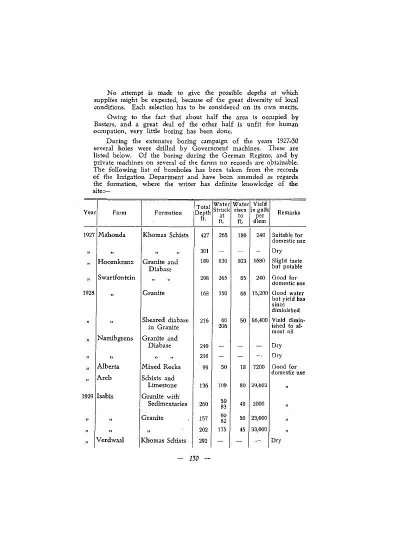
No attempt is made to give the possible depths at which supplies might be expected, because of the great diversity of local conditions. Each selection has to be considered on its own merits.
Owing to the fact that about half the area is occupied by Basters, and a great deal of the other half is unfit for human occupation, very little boring has been done.
During the extensive boring campaign of the years 1927_30 several holes were drilled by Government machines. These are listed below. Of the boring during the German Regime, and by private machines on several of the farms no records are o.btainable. The following list of boreholes has been taken from the records of the Irrigation Department and have been amended as regards the formation, where the writer has definite knowledge of the site:-
_ .. _ ... --- .- .- ....... - -Water T~;alj~:~~k Yield r
Year Farm Formation rises in galls Remarks Depth at to ft. ft. ft.
per diem
1927 Mahonda Khomas Schists 427 265 180 240 Suitable for domestic use
" " " " 301 - - - Dry
" Hoornkranz Granite and 189 130 103 1680 Slight taste Diabase but potable
" Swartfontcin
" " 298 265 85 240 Good for
domestic use
1928 " Granite 168 150 66 15,200 Good water
but yield has since diminished
" " Sheared diabase 216 60 50 86,400 Yield diminw
in Granite 206 ished to al-most nil
" Namibgrens Granite and Diabase 240 - - - Dry
" " " " 210 - - -. Dry
" Alberta Mixed Rocks 99 50 18 7200 Good for
domestic use
" Areb Schists and
Limestone 136 109 80 29,602 "
1 929 Isabis Granite with Sedimentaries 260 50 48 2000 83 "
Granite 157 6U 50 23,000 " " 82 " " " " 202 175 45 33,000
" "
Verdwaal Khomas Schists 292 - - - Dry
- 130 -

The above list could be supplemented by the record of wells dug on the v?rious farms. but these are even more unsatisfactory than one would expect, especially in the nature of the formation and the appmximate yield. It must be noted that the yield given in the table above is based on pumping or bailer tests of at most 9 hours, This time is too short, and the method too primitive for good results .. It has· happened, for instance in the case of one of the holes drilled on the farm Swartfontdn, that the yield per diem has fallen to almost nil, although the test showed 86,400 gallons per diem.
A brief resume of the various formations and their under"" ground water possibilities follows:':"'"
The Marienhof Series. The extent of these beds is really too small to be considered
in this connection, and besides their compact nat-ure is 'against the possibility of strong water supplies.
The DUl'uchaus Series. Thl<! schists of this Series are bad water carriers and the mh
caceous quartzites little more favourable, but the thicker marble bands have been proved to be fairly good sources of water. The £our wells sunk to the south and south"east of Natas prove this, also the well on Swartmodder to the north of N atas.
The Khomas Series. This on the wh'ole is oue of the worst water cauiers of th'e
whole area, and since some good pastoral farms are localed on th\!se schists it is a great drawback. The boreholes on Mahonda and Verdwaal cited above prove this. Boreholes have also been sunk on Hartdust, Naos, Friedental, Hefner, Hohenhdm and Choaberib with varying degrees of success. Where the boreholes have been successful as on Naos .and Chbaberib there is always a oontributary cause, such' as the presence of a band of sandstone or marble in ihe compact schists. The same applies to wells sunk in this formatLon. The very productive wells on the upper reaches of the Djab river sunk by the Bassingthwaighte brothers m 1930 are located on a porous sandstone band in the schists. The porosity is increased by the fact that a certain percentage of calcite and pyrite \tas been leached out of the sandstone. Nowhere
'to the knowledge of the writer has a decent supply of water been tapped in the compact schists of this Series. If water is found, however, it can be reckoned on to be of good quality.
The Marble Series. This is the best formation for sources of underground water1
and Where a moderately thick band of this formation crosses a strip of land it is practically certam that water can be obtained by means of a well or borehole. The wells on Hakskeen, Gurw manas, Vaalgr.as, the boreholes on Naos, the caves on Naos, the
-131

wells to the west of Tsebris, some wells and boreholes on Choaberib, the well on Doornboom, and the borehole on W cisscnfels arc all on this band of marble. So are the borehole and wells on Portsmrut, and the twenty or more Kuiseb sprit'll,gs mentioned in the opening chapters of this report all originate on this horizon or its equivalent, the graphite scbists.
The quality of ·water from this Series suffers in comparison witl, that obtained from the schists. It is usually hard, and con_ tains quantities .of MgSO" and where the site is located in the graphitic schists, or when these arc encountered in the borchole or well, the water usually smells of H 2S and rarely of SO, which: makes it quite unpotable . The supplies from these marbles' arc usually c-opious, and in several cases, for instance at the Naos homestead, the water level has never been known to fall apprecL:o ably even after th~ severest droughts, and with day and night pumping.
The Quartzite Series. Wherever this Series is dev,el.oped to any thickness it is almost
always overlain by the Marble Series, and has on this account seldom been tapped for its underground water,"upply. It is not an unfavourable formation, in fact the extensive d!!vclopmen:t of the basal conglomerates north of Aroams, and the fault lines of Tsebris with its thick tillitic grits should form very favourable sources of underground water.
Where the quartzites have been subJected t·o intense mechanic.'!i stress and oonsequent partial recrystallisation, the mass becomes too compact to be a reservoir for underground water.
The Nama Formation. (1) T;he Basal Beds. These Beds must be classed with the
best as far as water finding possibilities are concerned. In the .first place they were deposited on an uneven surface, and secondly they consist for the greater part of coarse sandstones, pebbly
. grits and conglomerates, and in the lower layers of ground agglo, merale. The occasional bands of mudstone and shale are bene. ficial rather than detrimental to the conservation of water. Un:::= fortunately no boring has been done on these beds, and the few wells in existence are too sl1allow to be any criterion of the above theoretical views.
(2) Th~ Schwarzkalk is another favourable formation for water finding. The intercalcated sandstone and shale beds act relatively as porous and impervious layers for the ground water while the shales of the Schwarzrand Series act as an impermeable layer for the limestones themselves. Again, the lack of boring and the very few wells chosen at suitable places prevents us from testing these observations. The fault lines of Rokskeur-Bullspoort, and the lesser faults north of Rokskeur can all be exploited to advantage.
- 132 -

The water obtained from these beds is usually hard and slightly brackish, but once used to it is not unpotable, ana locally believed to be very healthy. The best supplies obtained by wells in this formation are on Uikans, Garis, Nauzerus and Noab and the springs of Kanbis, Noab and Garis.
(3) The Schwarzrand Series. The shales are too impervious to be good water carriers, and the quartzites are very compact and hence not very favourable. Supplies of good water h'ave been tapped in these 'Iuartzi!es on Achaub and also to the west of Achaub. At both localities the water issues from master joints and fractures in th'e quartzite on the axes of local folds.
The Mixed Rocks. These rocks have been proved to carry supplies of underground
water where the schistose sedimentary mixture, or the gneiss, approaching granitic composition, is not too much in evidence. These mixed rocks usually contain crus~zones, and these are favourable. Strong supplies of good water have been obtained from these rocks -qu Arch, Alberta, Namibgrens, Na-uams and Morgenrothl
, and also on Kabiras and Auchas. The shelving debris~covered valleys, underlain by these mixed rocks, would with' judicial selection yield good supplies of water.
Granite. The massive granite should always be avoided, and even the
decomposed granite, although it might yield an enormous supply on opening uP. is net a permanent source, for instance the one borehole on Swartfontein. The valleys filled by granite debris usually yield good and lasting supplies, provided the subsoil is deep enough', and replenishment takes place from time to time. The borehole near the homestead on Morgenroth is an example of this sort. The granite. even in its most compact zones usually contains lines of crush or fracture, dykes of sheared diabasc or lenses of incorporated sedimentary rock on which small supplies of water can be obtained. The boreholes on Nauchas, Swartfontein and Isabis and the numerous wells on Namakorabis and throughout the Baster Gebiet, testify to the correctness of this. The supplies are of excellent quality, but dependent on the rainfall to such: an extent that in the winter of 1930 the majority of them dried up.
Recent Deposits. The water holes of the Namib are storage rather than under>
ground supplies, and are all of a temporary nature. The wells on Ababis in the Iime,cemented Namib detritus yield good and fairly constant supplies, but are undoubtedly being fed by a subflow in the Tsondap river.
C. STORAGE DAMS. Projects suitable for small farm darns abound in this area,
and many dams hav,e been constucted under the Government~
- 133 -

aided schemes. The dams built in schist areas are usually of cheap construction owing to sharp V _shaped valleys, but they have been found liable to silting_up. The dams in the large granite areas have been more expensive but more successful on the whole. As the result of dam construction, wells and bore_ holes in the immediate vicinity have in many cases been made to yield permanent supplies where formerly they dried up after the rainy season. Shallow barrages across stream beds and spruits thrown up at little cost, can in this way do much to relieve th~ acute distress often caused by water shortage.
D. TEMPORARY SUPPLIES.
The sandy bottoms of the rivers· and the occasional pans yield temporary supplies of drinking water after the rainy season and occasionally, as for instance, at Gurumanas, permanent supplies.
C H APT E R XlV.
AGRICULTURAL AND PASTORAL PROSPECTS.
The agricultural prospects of this area are almost nil, for apart from local horticulture and the growtng of maize and pumpkins along the larger rivers, there is no agriculture being practised, neither is the soil or rainfall favourable.
The farmers are all pastoral, and the area is eminently suitable for the raising of various kinds of stock.
Horse breeding was once a profitable and flourishing occupation botll in the Baster Gebiet and outside. Nauchas and Areb were the stud farms of the Imperial German Government, while Ababis was famous once for its thorougbbreds, and is today the only farm in this area where horse breeding is. still practised on a small scale. The coming of the motor car has practically ended this industry.
Cattle raising with its subsidiary cream"'production, has been the mainstay of the greater number of inhabitants. Lately some of the more progressive farmers have introduced full_blood stock· to improve their herds both as regards the milking and beef qualities. Swiss, Shorthorn, Aberdeen Angus, Simmenthalers and a few Frieslands have been noticed. What is needed for this area of rough veld and long distances to water is a type combining the milking qualities of the Swiss with the hardiness and beef qualities of the Afrikander.
Mrikander sheep and goats thrive exceedingly well in this area, and bothl Basters and white settlers produce an excellent quality of mutton and lamb.
134 -

Karakul breeding has become popular in the last few years" and the quality Qf pelt produced is second to none in South West Africa. Moreover. it is found that the cross between the Afrikander and Karakul produces a type well suited to the exacting climatic oonditions and in quality of mutton equal to the pure,bred Afrikander.
The pasture on the Khomas highlands is of a very good quality for cattle and sheep. but the abundance of quartz rubble and consequent "sharp" veld coupled with the sparsity of watering places results in part of the farms not being used. and the other part overstocked. This overstocking also applies to the other areas. and has the detrimental effect of destroying the good forage grasses followed by a spurious growth of "steekgras" and other hard grasses of little feed value.
The grazing on the granite veld is the best in this area. and were it not for the scarcity of water and the difficulty of "making" water most of these farms could carry far more stock than at present.
On the whole this area represents one of the best and heav West farming districts in South West Africa.;md it is a great pity that the best portion of it should belong to a people witl> such a lack 'Of enterprise as the Rehoboth Basters.
- 135 -