the freycinet map of 1811 - the first complete map of...
TRANSCRIPT

The Freycinet map of 1811 - The first complete map of Australia?
Peter Reynders and Rupert Gerritsen
The Freycinet map of Nouvelle Hollande is generally recognised as the first full map of
Australia to be published. But was it the first and was it published in 1811 making this year,
2011, the bicentenary of its publication.
In historical context the map is the culmination of a long chain of events in Australian
maritime contact history, both fictitious and real, and a product of hostilities between France
and Britain. It also provides a vicarious link between Australia and the towering historical
figure of Napoléon Bonaparte. Napoléon's name actually features on the map as Terre
Napoléon, perhaps less peculiar than the Latin word “Australia” as a geographical name on
our continent, even though we are used to it now.
Classical Greek philosophers had developed the idea of a spherical earth, confirmed by the
first circumnavigation of the globe by Magellan, who died along the way, and his second in
command Elcano, from 1519 to 1522. In the first century Claudius Ptolemy suggested there
ought to be a large continent surrounding and including the South Pole: a southland.
Renaissance cartographers resurrected his theory on their world maps and presented many
Latin names for it, including Terra Australis Incognita and Australia.
Figure 1 The Guerard Map: Carte Universelle Hydrographique (1634) State Library of New South Wales, Map M M2 100/1634/1
For example, this world map of 1634, by Frenchman Jean Guerard, shows this theoretical
southland. It was invariably presented in similar form throughout the 16th
century: to include
the South Pole and placed south of all other continents. This example illustrates that the 17th
century French map makers, like the better known Thévenot, were not particularly up-to-date
or accurate in their cartography as it was often a sideline. That would change in the 18th
century.

After Tasman sailed south of Tasmania in 1642, widely circumnavigating our continent on
that voyage, the world's cartographers rejected the notion that the continent was the
theoretical Southland. If it existed at all, they concluded, it would be around the South Pole.
Figure 2 Hondius’ Polus Antarcticus (1657) National Library of Australia, Map T 730
Hondius' modified map of the southern parts of the continents incorporates Tasman’s
information, with Australia now the third furthest south. Our emerging island continent had
already been excluded from the theoretical land mass of Terra Australis Incognita.
After Cook's voyages a consensus developed that there was no great Southland, or if there
was it was hidden under the ice of the South Pole Region. At a time that using Latin still
confirmed one's intellectual status, Matthew Flinders placed the Latin notions of Terra
Australis and Australia on his 1804 manuscript map of the continent. Suddenly it seemed the
name was back in favour because it was now unused for any landmass and therefore
available. This Latin translation for Southland was, therefore, no longer available when a
continent around the South Pole was indeed discovered deeper into the 19th
century, being
given the somewhat clumsy name of Antarctica.
The Freycinet map ''incorporates'' charting and reports by many other earlier mariners, such
as:
1. Janszoon, who had charted some of the west coast of Cape York in 1606,
2. Hartog, who had encountered and charted parts of Australia's west coast in 1616,
3. Nuyts and Thijssen, who had sailed along much of the south coast in the Gulden
Zeepaert in 1627,
4. Tasman touching Tasmania in 1642 and along the north coast in 1644
5. Vlamingh, who voyaged up the west coast in 1696-97,

6. Cook, who charted the east coast in 1770,
7. d’Entrecasteaux, Bass and Flinders, in refining the knowledge of the south coast and
of Van Diemen’s Land, establishing it as an island, and
8. Other cartographers on the Baudin expedition, Boullanger, Faure and Baudin.
French representation in the timeline of European maritime exploration of Australia is
considerable.
It begins with the fictitious encounter with our continent by Binot Paulmier de Gonneville, a
French navigator who claimed to have paid a visit to the great Austral land on his return
voyage to South America between 1503 and 1505.1
The first Frenchmen to actually visit Australia were eight French soldiers aboard the VOC
East Indiaman Batavia, wrecked on Morning Reef in the Wallabi Group of the Abrolhos
Islands off the coast of WA on 4 June 1629, and we know their names. In the subsequent
mutiny two of these Frenchmen were murdered by the Mutineers, but the others joined the
group who held out against them, the Defenders.2
Figure 3. Imaginary scene from the Batavia Mutiny Pelsaert 1647 Inside Frontispiece
The first recorded contact of a French vessel with Australia took place on 4 August 1687,
when Captain, later Admiral, Duquesne-Guitton, in l'Oiseau, sighted and sailed up the
Western Australian coast in the vicinity of the Swan River en route to Siam with Claude
Céberet du Boullay, to be the new French Ambassador there, and his staff.3
Over 80 Years later two close encounters followed: In 1768 Louis Antoine de Bougainville,
on the first French voyage around the world (with the first woman to circumnavigate the
globe on board: Jeane Barré) in La Boudeuse and l'Étoile, came within a few hundred
kilometres of the east coast of Australia, as did Jean de Surville in 1769.4
It was not until 1772 that another French ship actually visited Australia. Louis-François de St.
Allouarn left Mauritius in January 1772 and coming upon the coast of Western Australia

sailed north from Cape Leeuwin to Shark Bay. Here he landed on Dirk Hartog Island and
claimed the western part of Nouvelle Hollande for France. The bottle in which the document
claiming possession may have been sealed was actually found in 1998, although there was no
sign of the document.5
At the same time as St. Allouarn was claiming the west coast, Marc-Joseph Marion Dufresne,
en route to Tahiti, arrived in Van Diemen’s Land before sailing on to New Zealand where he
and some of his crew suffered a culinary catastrophe, being killed and eaten by Maoris.6
Following that was the better known voyage of Rear Admiral Jean François Galaup, Count of
LaPérouse, who sailed into Botany Bay in January 1788. Following a long and arduous
voyage through the Pacific he had received orders at Kamchatka to sail for Nouvelle Hollande
where he arrived in the Boussole and the Astrolabe at Botany Bay the day the First Fleet was
moving to Port Jackson. After his visit he sailed into the Pacific, and was not heard of again.
He is thought to have perished at Vanikoro, part of the Santa Cruz Islands.7
During 1792 and 1793 Rear Admiral Antoine de Bruni d’Entrecasteaux, circumnavigated
Nouvelle Hollande in the Recherche and the Espérance in search of LaPérouse. He visited
Tasmania twice, the charting of part of it being undertaken by his young, and now famous
hydrographer and cartographer Charles-François Beautemps-Beaupré.8
The Freycinet map can also be considered an outcome of an extended period of Anglo/Gallic-
French/English rivalry. The expansionist policies of the rulers of France resulted in repeated
war with England over a period of about eight centuries. Early French rulers, such as the first
Christian Franconian King Chlodovech (Clovis), taking his cue from the Romans, then
Charlemagne
Figure 4 King Chlodovech [Clovis]
and even Guillaume le Bâtard (also known as William de Conqueror) established an
aggressive tradition of territorial expansion, reciprocated by the English. This escalated
centuries later under Louis XIV into a string of wars against Britain and its allies. Louis XIV
failed largely because of the better quality of the British Navy. The terms of the Treaty of
Utrecht and of Ranstatt at the end of the war of Spanish Succession in 1713, saw him
humiliated and he died in 1715, 100 years before the Battle of Waterloo, where a similar fate
would await France.

The Anglo-French hostilities of the Seven Years War, where Bougainville and Cook both
fought in North America, but on opposite sides, ended in a humiliating defeat in 1763. France
lost its North American and Indian colonies. The urge to compensate for this was an
important French sentiment for the rest of the 18th
century.
Towards the end of that century came the French Revolution. Britain had already had its civil
war. It had beheaded the king and had its Republic from the late 1640's achieving a
constitutional monarchy after its “Glorious Revolution” in 1688. There was no longer any
need to conquer feudalism through violent revolution. France, however, was still suffering a
badly managed feudal system in the 18th
century. Influential writers like Montesquieu,
Voltaire and Rousseau represented feudalism as a complete anachronism. This stimulated the
arrival of a violent and chaotic revolution, where the power initially landed with mob leaders,
such as Robespierre, Danton and the bloodthirsty Marat, some of whom ended up on the
guillotine themselves. Out of its revolutionary melee emerged army officer Napoléon
Bonaparte, rising quickly through the ranks, thanks to his military successes in continental
Europe. He became First Consul, heading an all powerful troika, as a result of his Coup d'État
de Brumaire in 1799.
Figure 5 Napoléon Bonaparte
There was a concerted French effort at this time to try and match the British Navy and its
navigational standards, and hopefully its successes. From this milieu emerged the idea of the
Baudin Expedition to Nouvelle Hollande. It was approved by First Consul Napoléon, partly in
response to the British settlement at Sydney Cove. A year after Baudin's ships came back
from Nouvelle Hollande in 1804, without him as he has died in Mauritius, the French fleet
was defeated at Trafalgar. The then Emperor Napoléon agreed in 1806 that scientist Péron and
hydrographer de Freycinet would have access to the records of Baudin's voyage and prepare a
glorious narrative of the latest French voyage to Nouvelle Hollande, and publish it along with
the first full map of this island continent.

Figure 6 Matthew Flinders
The Englishman Matthew Flinders meanwhile, was under house arrest in Mauritius,
compliments of its Governor and confidant of Napoléon, General Charles Decaen.
Consequently, Flinders was not in a position to publish his narrative and map of Terra
Australis until 1814, following his returned to England after being detained in Mauritius for
six years. And so it would seem the first full continental map of the continent was published
in Paris in 1811.
The Baudin expedition was intended to be a voyage of discovery that would further scientific
knowledge and perhaps eclipse the achievements of James Cook. Napoléon Bonaparte, as
First Consul, formally approved the expedition ‘to the coasts of New Holland’,9 after
receiving a delegation of Baudin and eminent members of the Institut National des Sciences et
Arts on 25 March 1800. The explicit purpose of the voyage was to be ‘observation and
research relating to Geography and Natural History.’10
Among those joining the Baudin expedition’s ships, the Géographe and Naturaliste, were
Sub-Lieutenants Louis-Claude [Louis] de Saulses de Freycinet and his older brother Henri-
Louis [Henri]. Ironically, Louis did not initially sail as a ‘geographer’. Both were eventually
promoted to Lieutenant, and Louis was later given command of the schooner Casuarina,
purchased in Sydney to enable improved inshore surveying. Another member of the
expedition, someone who was ultimately to have a highly significant influence on its
outcomes, was of course the 25 year old Assistant Zoologist François Péron.
So, with ‘600 leagues’ of unexplored south coast in New Holland, and the prospect of new
discoveries beckoning, the expedition departed Le Havre on 19 October 1800. In this context
much has been made of the claim that Baudin and his rival Matthew Flinders were also
engaged in a race to find a fabled north-south strait, ‘Williamson’s Strait’, running from the
south coast through the middle of Australia to the Gulf of Carpentaria.11
However, to what
extent Baudin and Flinders were aware of, or seriously entertained the possibility that such a
strait existed, is an open question. Although some researchers have claimed in more recent
times that ‘it was rumoured,’ there was ‘speculation,’ it was ‘a long-held mystery,’ or that it
was ‘general opinion’ at the time that such a strait existed,12
no evidence for these claims
prior to September 1800.13
Flinders, while acknowledged that ‘geographers were disposed to
give the appellation of Continent’ to Australia, nevertheless claimed ‘doubts still existed’ that

Australia was a continent and not a number of large islands.14
But we believe the real intent
was to eliminate all possible doubt that continental Australia was a single landmass,
principally because of its implications for British territorial claims in New Holland, as well as
to find a route into inland Australia. Flinders alludes to this, noting that the establishment of
the colony in New South Wales, ‘has added a degree of interest to the question of
continuity.’15
Consequently, his instructions for the exploration of the south coast directed
that:
in case you should discover any creek or opening likely to lead to an inland sea or strait
[original emphasis], you are at liberty, either to examine it or not, as you shall judge it most
expedient, until a more favourable opportunity shall enable you so to do.16
Baudin’s instructions however, prepared for him by the likes of Jussieu, Bougainville, Comte
de Fleurieu and the mathematician Laplace, make no mention of this hypothetical strait, nor
give any specific direction to search for it. Moreover, neither Baudin nor Flinders, following
their famous meeting at Encounter Bay on 8-9 April 1802, mention it all in their journal
entries, and it would seem that it was not even discussed.17
From a scientific viewpoint the Baudin expedition was an outstanding success. In geographic
terms much of Australia’s coastline had been explored, though they had been gazumped by
Flinders in the Investigator and Lt. Grant in HMS Lady Nelson in charting the previously
unknown part of the south coast. Just about all the expedition could lay claim to discovering
was a small stretch of the coast of South Australia, from Mt. Schanck to Encounter Bay.
Publication of the volumes giving the official account of the expedition, Voyage de
Découvertes aux Terres Australes, and the associated atlases, was authorised by Napoléon on
4 August 1806. Péron, along with naturalist Lesueur, was given responsibility, with Louis de
Freycinet, who had already been working on the charts, to undertake the cartography.
Figure 7 The Freycinet map de Freycinet 1811a, National Library of Australia, Map RaA 1 Plate 1

But a range of difficulties and delays arose, and it took ten years for the project to be
completed, resulting in some confusion in the order of publication.18
The first volume,
Historique, was published in 1807, but the second volume, also Historique, was not published
until 1816, although volume 3, Navigation et Geographie, had already been published in
1815. This was partly due to the death of Péron in 1810, from tuberculosis, when de Freycinet
took over responsibility for the final volumes, and partly strained government finances.
A number of controversies arose with the publication of the volumes and maps. Included in
these was the almost complete elimination of any reference to Baudin and, it seems at Péron’s
behest, the application of French names to many geographic features and coasts already
explored and named by other navigators, particularly Flinders.19
In discussing the Freycinet map as the first map of Australia care needs to be taken in
qualifying what one means. Flinders prepared a map of Australia in 1804,20
while detained in
Mauritius, courtesy of one of Napoléon’s confidants, General Decaen. But this was a ‘fair
drawing’, a manuscript map, which was not published until 1814, and then in modified form.
Use of the term ‘complete’ map of Australia is not strictly correct either, in relation to both
the Freycinet and the Flinders maps. Both have numerous small gaps where inlets were
missed or it was too dangerous to undertake close surveying. Hence the term ‘full’ is used, as
the full outline of Australia is finally discernable. Thus, the Freycinet map is generally
regarded as the first full map of Australia to be published. But is this really the case? Are
there are other maps which could be considered as possible candidates as full maps of
Australia published prior to 1811.
Addressing this question, the first reference to the publication of a full map of Australia is in
part 1 of the Atlas Historique of 1807,21
accompanying the first volume of Voyage de
Découvertes. In the table of contents is listed ‘Carte Générale de la Nouvelle Hollande’
[General Map of New Holland].
Figure 8 Table of Contents of Atlas Historique Peron 1807
But when one looks, it does not appear to be there. For his 1910 book on the Baudin
expedition, Terre Napoléon, Professor Scott examined four original editions but was unable
to locate any such map in that publication.22
One of us (Gerritsen) examined a further nine
original editions, with the same result. However, the explanation was actually already evident
in 1816, with a note indicating the map intended for part 1 of Atlas Historique had been
‘presents avec plus de details et dans un autre ordre dans l’atlas historique, 2e partie.’
[‘presented with more detail and in another order in Atlas Historique, part 2.’].23
In other
words the map was in the second part of Atlas Historique, published in 1811, largely because
the engraver had not been paid.
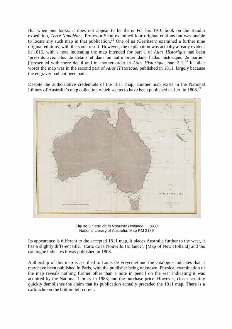
Despite the authoritative credentials of the 1811 map, another map exists in the National
Library of Australia’s map collection which seems to have been published earlier, in 1808.24
Figure 9 Carte de la Nouvelle Hollande ... 1808 National Library of Australia, Map RM 2189
Its appearance is different to the accepted 1811 map, it places Australia further to the west, it
has a slightly different title, ‘Carte de la Nouvelle Hollande’, [Map of New Holland] and the
catalogue indicates it was published in 1808.
Authorship of this map is ascribed to Louis de Freycinet and the catalogue indicates that it
may have been published in Paris, with the publisher being unknown. Physical examination of
the map reveals nothing further other than a note in pencil on the rear indicating it was
acquired by the National Library in 1983, and the purchase price. However, closer scrutiny
quickly demolishes the claim that its publication actually preceded the 1811 map. There is a
cartouche on the bottom left corner:

Figure 10 Cartouche of Carte de la Nouvelle Hollande ... 1808
which when translated indicates, ‘This map is an exact reproduction of that contained in the
first edition of Voyage aux Terres Australes’ Thus it is simply a copy of the map contained in
the first edition of Voyage de Découvertes, and so must have been published after 1811.
Further examination shows that much of the nomenclature has been changed to reflect the
precedence ascribed to Flinders, following publication of his map in 1814.
Professor Scott refers to a map of this form, claiming it was published in a revised Atlas in
1817.25
But no trace of any such atlas can be found.26
An antiquarian bookseller, offering a
copy of this map, claims it comes from a revised atlas published in 1815.27
Again, no trace of
any revised atlas from this period can be found. However, if one examines the second edition
of Voyage de Découvertes, published in 1824, the explanation of this conundrum becomes
clearer. There, in the Atlas of this publication, is a map identical to the ‘1808’ map.28
The
‘1808’ on the map simply reflects the state of cartographic knowledge at the time of the map’s
preparation, not the date of publication. ‘1808’ in fact also appears on the cartouche of the
1811 map. Thus we can conclude the ‘1808’ map was published after 1814 and is probably a
single sheet reproduction of the ‘Carte de Nouvelle Hollande’ contained in the 1824 Atlas.
The penultimate example of a map that could lay claim to being an earlier map than the 1811
Freycinet map is one showing Australia as ‘Nouvelle Hollande’, with ‘Océanique Centrale’
inscribed on a cartouche formed by an illustration of a Tasmanian bark-bundle canoe.

Figure 11 Océanique Centrale, 1809 Tooley, Plate 67
According to one of the most respected authorities on Australian cartographic history, Ronald
Tooley, this map was prepared by Pierre Lapie and published in 1809.29
As Lapie was at the
time Chief of the Topographic Section of the War Office in France,30
and possibly privy to the
cartographic work of the Baudin expedition, such a claim must be taken seriously. However,
internal evidence in terms of the nomenclature on the map suggests this date may be wrong.
In 1810 a review of the English translation of the first volume of Péron’s Voyage de
Découvertes was published.31
The anonymous reviewer, thought to be John Barrow, Secretary
to the Admiralty, indicated he had seen copies of some of Flinders charts and papers,32
and
took issue with the application of French names to Flinders’ and others’ prior discoveries,
citing some examples, including Kangaroo Island and North West Cape.33
And there on ‘Océanique Centrale’ one finds a number of instances where dual names were
applied.

Figure 12 Portion of Océanique Centrale, 1809
Kangaroo Island for example, the French ‘Île Decrès’, has adjacent to it in brackets ‘I. des
Kangourous selon Flinders.’ This dual naming would seem to place the publication of
‘Océanique Centrale’ after 1810. In fact, it appears in an atlas of Lapie’s maps, Atlas Complet
du Précis de la Géographie Universelle, published in 1812.34
In this publication we find a statement that Lapie had in fact been denied access to Louis de
Freycinet’s cartographic information.
Pour donner à plusiers parties de cette Carte un plus grand degree d’exactitude, nous
aurions desire pouvoir consult la grande and Carte de la Nouvelle-Hollande, que M.
Freycinet, captaine de marine, addressée pour l’Atlas du Voyage aux Terres Australes;
mais un devoir rigoureux defendoit à M. Freycinet de nous la communiquer: nous n’en
avons pas pu profiter.35
[To provide all the parts of this map with a greater degree accuracy we would have
preferred to be able to consult the map of New Holland, by M. Freycinet, sea captain,
author of the Atlas of Voyage to the Southern Lands. But strict adherence to duty
prevented M. Freycinet from communicating with us: we have not benefitted.]
It seems he did indeed rely upon other sources, such as the 1810 review written by Barrow,
and a memoire and a small manuscript map sent by Flinders to Annales des Voyages, edited
by geographer Conrad Malte-Brun. From this conjunction of evidence it is believed Tooley
was in error, and ‘Océanique Centrale’ is now ascribed a publication date of 1812.

The last example is a map from an atlas in the Bibliothèque Nationale de France, Précis de la
Géographie Universelle, published in 1810 by Malte-Brun,36
recently brought to our attention
by Dr Bronwen Douglas of the Australian National University.
Figure 13 Océanique 1810 Précis de la Géographie Universelle, Map 22
Online Digital Sources and Annotation System
As can be seen it is a regional map of Oceania, not specifically of Australia, but one that does
show a full outline of Australia. The author of the map is Pierre Lapie, who, according to the
cartouche, prepared it in 1809. A close examination reveals an accurate and detailed coastline,
and some names appear such as ‘Gulphe Bonaparte’, ‘Île Decrès’ and ‘Terre Napoléon’.
Figure 14 Portion of Océanique, 1810

This is from a version held by the National Library of Australia.37
This copy has been given a
possible publication date of 1812, but it would appear that this in fact it is a single sheet
reproduction of the 1810 ‘Océanique Centrale’ map.
It is worth noting that in the 1810 Précis de la Géographie Universelle there is also a mappe-
monde showing, perhaps for the first time, a map of the world with a full outline of Australia.
Figure 15 Précis de la Géographie Universelle, Mappe-monde, 1810 Malte-Brun 1810
Online Digital Sources and Annotation System
In view of Lapie’s statement in the 1812 atlas that he did not have direct access to de
Freycinet’s charting, it is a mystery how he was able to map the blank part of the south coast
by 1809. He stated that he had drawn from the first volume of Voyage de Découvertes from
1807,38
but there is insufficient detail in that, and none of the other sources he used for the
1812 atlas appear to have been available in 1809. This mystery may well be a matter for
future research.
Having thus considered and eliminated known contenders to the Freycinet map of 1811, we
are therefore able to conclude with some confidence that it was indeed the first full map
explicitly of Australia as such to be published.
Acknowledgements
We would like to acknowledge the work of Thomas Perry and Dorothy Prescott who laid the
foundations for this paper, and thank Dr Bronwen Douglas for drawing our attention to Malte-
Brun’s Précis de la Géographie Universelle.

Notes
1 Perrone-Moisés 1995; Sankey 2006.
2 Pelsaert 1629, pp.148-9,240.
3 Godard 2000.
4 Horner 1987, pp.46-7.
5 Cramer, 1999, 295-314.
6 Duyker 1994, pp.126-163.
7 King 1999.
8 Duyker and Duyker 2001.
9 Horner, 1986, p.40.
10 ‘Plan of Itinerary for Citizen Baudin’ in Baudin, 2004, p.1.
11 See for example Toft, 2002.
‘Williamson’s Strait’ was named after a reputed voyage by American Captain Williamson through
central Australia (Toft 2002, pp.11,75,91). 12
See Toft, pp.11,75,91; Tiley, p.108; Horner, p.219; Scott, p.25-26n1. 13
Flinders first claimed there was a conjecture that a strait that ‘dismembers New Holland’ could exist
in a note appended to his report on the voyage of the Norfolk in 1799 (Historical Records of New South
Wales, volume 3, p.817). The earliest specific reference to a strait from the south coast to the Gulf of
Carpentaria is ‘Letter: Matthew Flinders to Joseph Banks, 6 September 1800’, (Banks Papers, Section
13:Series 65.01CY 3009/181). 14
Flinders, vol. 1, p.i. 15
Flinders, vol. 1p.,i.
Fuller discussion of this issue is beyond the scope of this paper, but we hope to address it in a
forthcoming paper. 16
Flinders, vol. 1, p.8. 17
Péron 1807, pp.324-5; Brown, 2001, pp.177-79 18
Péron 1807; Petit and Lesueur 1807; de Freycinet 1811b; de Freycinet 1812; de Freycinet 1815;
Péron and de Freycinet 1816. 19
The causes of this are still being debated. See for example Fornasiero, Monteath and West-Sooby
2006. 20
Flinders 1804. 21
Petit and Lesueur 1807. 22
Scott, p.73. 23
Péron and de Freycinet 1816, p.467. 24
L. Freycinet, Carte de la Nouvelle Hollande/dressée par M. L. Freycinet, Commandant la Goëlette le
Casuarina 1808 (NLA Map RM 2189) 25
Scott, p.89. It can be ascertained Scott is referring to this map as he quotes from cartouche. 26
Despite searching the National Library catalogue, Libraries Australia catalogue, consulting rare book
catalogues (Wantrup 1987, Horden House 2010), and searching the internet. 27
Personal communication – D. Lilburne, Antipodean Booksellers, 12/1/2011. 28
Péron 1824 Atlas, No. 1. Verified in Perry and Prescott, p.188. 29
Tooley 1987, p.112, Plate 67. 30
Tooley, p.111. 31
Anon. 1810. 32
Anon., p.52. 33
Anon., p.53. 34
Malte-Brun 1812, Plate LXII. 35
Lapie in Atlas complet 1812, p.9. 36
Malte-Brun 1810. 37
Map T 841. 38
Lapie in Atlas Complet 1812, p.9.

References
Anonymous [John Barrow], 1810 “Review of Voyages de Découvertes aux Terres
Australes”, Quarterly Review, 4(7): 42-60.
Baudin, Nicolas, 2004 The Journal of Post Captain Nicolas Baudin, Commander-in-
Chief of the Corvettes Géographe and Naturaliste, C. Cornell (trans.), Friends
of the State Library of South Australia, Adelaide.
Brown, Robert, 2001 Nature’s Investigator: The Diary of Robert Brown in Australia,
1801-1805, T. G. Vallance, D. T. Moore and E. W. Groves (comps),
Australian Biological Resources Study, Canberra.
Cramer, Max, 1999 Treasure, Tragedies and Triumphs of the Batavia Coast, Scott
Four Colour Print, Perth.
de Freycinet, Louis, 1811a “Carte Générale de la Nouvelle Hollande, dressée par M.
L. Freycinet, Commandant la Goëlette le Casuarina, an 1808”, Imprimerie par
Langlois, Paris. [National Library of Australia: Map RaA1. Plate 1, Part 5.
http://nla.gov.au/nla.map-raa1-s5].
1811b Voyage de Découvertes aux Terres Australes ... (Atlas Historique) –
Part 2, De l'Imprimerie Imperiale, Paris.
1812 Voyage de Découvertes aux Terres Australes ... (Atlas, Partie
Navigation et Geographie), De l'Imprimerie Imperiale, Paris.
1815 Voyage de Découvertes aux Terres Sustrales ... (Navigation and
Geographie), De l'Imprimerie Imperiale, Paris, tome 3.
Duyker, Edward, 1994 An Officer of the Blue: Marc-Joseph Marion Dufresne, South
Sea Explorer,1724 – 1772, Melbourne University Press, Melbourne.
Duyker, Edward and Duyker, Maryse 2001 Bruny d’Entrecasteaux: Voyage to
Australia and the Pacific, 1791 - 1793, Miegunyah/Melbourne University
Press, Melbourne,
Flinders, Matthew, 1804 “Australia or Terra Australis: chart shewing such parts of
Terra Australis and its vicinity, as were discovered or examined by the
following vessels: Schooner Francis of 60 tons burthen, in 1798; Sloop
Norfolk of 25 tons, in the years 1798 and 9; Schooner Cumberland of 29 tons
burthen, in 1803; and by His Majesty's Ship Investigator in 1801, 2 and 3 by
Matthew Flinders”, United Kingdom Hydrographic Office, Y461.
1814 A Voyage to Terra Australis ..., 2 vols, G. & W. Nicol, London.
Fornasiero, Jean, Monteath, Peter and West-Sooby, John 2006 “Hydrographic
reputations: Matthew Flinders, Nicolas Baudin and Australia’s unknown
coast”, The Hydrographic Journal, 121:17-23.
Godard, Phillipe, 2000. “French maritime history in WA”, Quarterly Newsletter of the
Australian Association for Maritime History, 79:3-4.
Horden House Rare Books 2010 Captain Louis de Freycinet and his Voyage to Terres
Australes, Horden House, Potts Point.
Horner, Frank, 1987 The French Reconnaissance: Baudin in Australia 1801-1803,
Melbourne University Press, Carlton.
King, Robert 1999 “What brought Lapérouse to Botany Bay?”, Journal of the Royal
Australia Historical Society, 85(2):140-147.
Malte-Brun, Conrad 1810. Précis de la Géographie Universelle, ou Description de
Toute les Partie du Monde, sur un Plan Nouveau, d’Après les Grandes
Divisions Naturelles du Globe ... Collection de Cartes Géographiques

Dirigées par Malte-Brun, Dressées par MM. Lapie et Poirson, et Gravées par
MM Tardieu aîné, Chamouin et Tardieu Cadet, François Buisson, Paris.
1812 Atlas Complet du Precis de la Geographie Universelle de M. Malte
Brun: Dressée Conformement au Texte de Cet Ouvrage et Sous les Yeux de
l'Auteur, par M. Lapie, Chez François Buisson, Paris.
Pelsaert, Francisco, 1629. “The Journals of Francisco Pelsaert”, in Henrietta Drake
Brockman, Voyage to Disaster, Angus & Robertson, London, 1982. pp.122-
254.
1647. Ongeluckige Voyagie van ‘t Schip Batavia, Naer de Oost-Indien:
Gebeleven op de Abrolhos van Frederick Houtman, Jan Jansz, Amsterdam.
Péron, François, 1807 Voyage de Découvertes aux Terres Australes ... (Historique),
De l'Imprimerie Imperiale, Paris, tome 1.
Péron, François and de Freycinet, Louis 1816. Voyage de Découvertes aux Terres
Australes ... (Historique), De l'Imprimerie Imperiale, Paris, tome 2.
Péron, François, (continué par M. Louis de Freycinet) 1824. Voyage de Découvertes
aux Terres Australes ... (Historique). Atlas, Arthus Betrand, Paris, 2nd
edition.
Perrone-Moisés, L., 1995 Le voyage de Gonneville (1503-1505) et la Découverte de
la Normandie par les Indiens du Brésil, Ariane Witkowski (trans.), Edition
Chandeigne, Paris.
Perry, Thomas and Prescott, Dorothy, 1996 A Guide to Maps of Australia in Books
Published 1780-1830, National Library of Australia, Canberra.
Petit, Nicolas-Martin & Lesueur, Charles-Alexandre, 1807. Voyage de Découvertes
aux Terres Australes ... (Atlas historique) - Part 1, De l'Imprimerie Imperiale,
Paris.
Sankey, Margaret, 2006 Mémoires Touchant l’Establissement d’une Mission
Chrestienne dans les Troisième Monde: Autrement Appelé la Terres
Australes, Méridional, Antarctique et Inconnuë by the Abbé Jean Paulmier
(1663), Champion, Paris.
Scott, Ernest, 1910 Terre Napoléon: A History of French Explorations and Projects in
Australia, Methuen, London.
Tiley, Robert, 2002 Australian Navigators: Picking up the Shells and Catching
Butterflies in an Age of Revolution, Kangaroo Press, East Roseville.
Toft, Klaus, 2002 The Navigators: The Great Race Between Matthew Flinders and
Nicolas Baudin for the North-South Passage Through Australia, Duffy and
Snellgrove, Sydney.
Tooley, Ronald Vere, 1985 The Mapping of Australia and Antarctica, Holland Press,
London.
Wantrup, J., 1987 Australian Rare Books, Hordern House, Sydney.