the findlay industrial partnership … in the rusty ridge area between middle findlay creek and the...
TRANSCRIPT
THE FINDLAY INDUSTRIAL PARTNERSHIP PROJECT: GEOLOGY AND MINERAL OCCURRENCES OF THE FINDLAY - DOCTOR
CREEK AREAS, SOUTHEASTERN BRITISH COLUMBIA (parts of 82F/16,82Wl)
By D. A. Brown, B.C. Geological Survey Branch, and Tim Termuende, Eagle Plains and Miner River Resources Ltd.
KEYWORDS: Proterozoic, Purcell Supergroup, Aldridge Formation, Greenland Creek stock, White Creek batholith, Sedex deposits, fragment&.
INTRODUCTION Previous Work
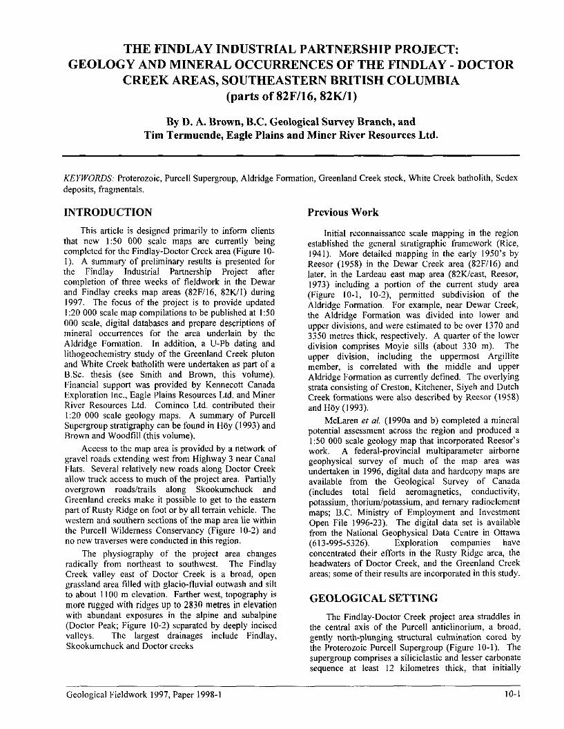
This article is designed primarily to inform clients that new 1:50 000 scale maps are currently being completed for the Findlay-Doctor Creek area (Figure IO- 1). A summary of preliminary results is presented for the Findlay Industrial Partnership Project after completion of three weeks of fieldwork in the Dewar and Findlay creeks map areas (82F/16, 82Wl) during 1997. The focus of the project is to provide updated I:20 000 scale map compilations to be published at I:50 000 scale, digital databases and prepare descriptions of mineral occurrences for the area underlain by the Aldridge Fommtion. In addition, a IJ-Pb dating and lithogeochemistry study of the Greenland Creek pluton and White Creek batholith were undertaken as part of a B.Sc. thesis (see Smith and Brown, this volume). Financial support was provided by Kennecott Canada Exploration Inc., Eagle Plains Resources Ltd. and Miner River Resources Ltd. Cominco Ltd. contributed their I:20 000 scale geology maps. A summary of Purcell Supergroup stratigraphy can be found in H6y (1993) and Brown and Woodtill (this volume).
Initial reconnaissance scale mapping in the region established the general stratigraphic framework (Rice, 1941). More detailed mapping in the early 1950’s by Reesor (1958) in the Dewar Creek area (82F/l6) and later, in the Lardeau east map area (82Weast, Reesor, 1973) including a portion of the current study area (Figure IO-l, IO-2), permitted subdivision of the Aldridge Formation. For example, near Dewar Creek, the Aldridge Formation was divided into lower and upper divisions, and were estimated to be over 1370 and 3350 m&-es thick, respectively. A quarter of the lower division comprises Moyie sills (about 330 m). The upper division, including the uppermost Argillite member, is correlated with the middle and upper Aldridge Formation as currently defined. The overlying strata consisting of Creston, Kitchener, Siyeh and Dutch Creek formations were also described by Reesor (1958) and Hiiy (I 993).
Access to the map area is provided by a network of gravel roads extending west from Highway 3 near Canal Flats. Several relatively new roads along Doctor Creek allow truck access to much of the project area. Partially overgrown roads/trails along Skookumchuck and Greenland creeks make it possible to get to the eastern part of Rusty Ridge on foot or by all terrain vehicle. The western and southern sections of the map area lie within the Purcell Wilderness Conservancy (Figure 10-2) and no new traverses were conducted in this region.
The physiography of the project area changes radically from northeast to southwest. The Findlay Creek valley east of Doctor Creek is a broad, open grassland area filled with glacio-fluvial outwash and silt to about II00 m elevation. Farther west, topography is more rugged with ridges up to 2830 metres in elevation with abundant exposures in the alpine and subalpine (Doctor Peak; Figure I O-2) separated by deeply incised valleys. The largest drainages include Findlay, Skookumchuck and Doctor creeks
McLaren et al. (1990a and b) completed a mineral potential assessment across the region and produced a 1:50 000 scale geology map that incorporated Reesor’s work. A federal-provincial multiparameter airborne geophysical survey of much of the map area was undertaken in 1996, digital data and hardcopy maps are available from the Geological Survey of Canada (includes total field aeromagnetics, conductivity, potassium, thorium/potassium, and ternary radioelement maps; B.C. Ministry of Employment and Investment Open File 1996-23). The digital data set is available from the National Geophysical Data Centre in Ottawa (613-995-5326). Exploration companies have concentrated their efforts in the Rusty Ridge area, the headwaters of Doctor Creek, and the Greenland Creek areas; some of their results are incorporated in this study.
GEOLOGICAL SETTING
The Findlay-Doctor Creek project area straddles in the central axis of the Purcell anticlinorium, a broad, gently north-plunging structural culmination cored by the Proterozoic Purcell Supergroup (Figure 10-I). The supergroup comprises a siliciclastic and lesser carbonate sequence at least 12 kilometres thick, that initially
Geological Fieldwork 1997, Paper 1998-l IO-I

accumulated in an intracratonic rift basin. The strata are preserved in an area 750 kilometres long and 550 kilometres wide, extending from southeastern British Columbia to eastern Washington, Idaho and western Montana. The original extent and geometry of the basin is poorly known in part because the western and northwestern margins are poorly exposed and in part due to Laramide contractional deformation.
Stratigraphy
Most of the project area is underlain by the Aldridge Formation, the lowermost Purcell Supergroup strata, although the base is not exposed. Excellent examples of the lower and middle parts of the Aldridge Formation occw in the Rusty Ridge area between Middle Findlay Creek and the headwaters of Greenland Creek (Figure 10-2). The lower Aldridge is thin bedded to laminated and rusty brown weathering, in contrast to the medium to thick bedded, grey weathering turbidites of the middle Aldridge Formation. Middle Aldridge tirbidite beds display normal grading, flame structures, load casts and rare ripples.
The contact behveen lower and middle Aldridge rocks is gradational and includes an extensive fragmental unit, here called the LMC fragmental (see
below). An important change from the more evenly bedded lower energy units of the lower Aldridge to rapidly deposited turbiditic sedimentation characteristic of the middle Aldridge suggests a fundamental change of the Purcell Basin sedimentation/tectonics at this time.
Much of the lower Aldridge succession exposed in the area is muscovite-biotite schist (meta-wacke) adjacent to the White Creek Batholith, in the vicinity of the Silver Key occurrence (Mint& 082KSE053; Figure 10-2). Minor quartz pods and lenses with black tourrnaline crystals occur within the most schistose zones of this area.
The upper Aldridge comprises less than 250 m of dark grey argillaceous phyllite that weathers dark rusty brown. Tight southeast-verging minor folds and coarse crenulations are evident in outcrops along the access trail to the Alpine occurrence (Mintile 082KSE081).
The Creston Formation consists of pale grey to green argillite with interlaminated greenish siltstone, and minor pale grey quartz arenite. Lenticular and wavy bedforms, argillaceous rip-up clasts, and tectonically flattened mudcracks distinguish the Creston from the Aldridge Formation. The medium to thin bedded quartz wacke and argillite commonly displays a sericitic phyllitic foliation. The formation was only examined around the Alpine showing and west of the Dot
Figure 10-1. Simplified geology for the bulk of the Purcell Anticlinorium (modified from H6y ef al., 19951, and an illustration of the geological framework for the Findlay-Doctor Creek project area. HE = Hellroaring Creek pluton, HLF = Hall Lake fault, KF = Kimberley fault, CR = Greenland Creek pluton, MF = Moyie fault, OBF = Old Baldy fault, PF = Purcell fault, SMF = St. Mary fault, SRMT = Southern Rocky Mountain Trench.
IO-2 British Columbia Geological Survey Branch
occurrence (Mint& 082KSE060). In these areas discrete schistose shear zones and southeast-verging minor folds are common. Narrow (<IO m thick), dark green matic sills and dikes locally intrude the Creston Formation.
Intrusive Rocks
Two contrasting Middle Proterozoic magmatic suites intrude the lower and middle Aldridge Formation: the laterally extensive gabbroic Moyie sills and small bodies of leucocratic pegmatite, and quartz monzonite that comprise the Greenland Creek stock. The middle Cretaceous White Creek Batholith dominates the southeastern quarter of the map area.
Middle Proterozoic Moyie Intrusives
Middle Proterozoic Moyie Intrusives are the oldest magmatic rocks in the area (cf Brown and Woodtill, this volume). They are massive to locally well foliated meta- diorite and amphibolitic gabbro forming dark green to brown weathering sills. Amphibole has largely replaced primary pyroxene phenocrysts (Mackenzie, 1971). The sills provide good local markers that have been clearly offset in excellent exposures along Rusty Ridge. The majority of the sills in the study area are about IO to 100 m thick and cumulatively comprise up to 25% of the lower Aldridge section. They rarely cut up or down section to form dikes. Albite alteration along sill contacts is well developed, especially at the headwaters of Greenland Creek. U-Pb isotopic dating of the Moyie sills have returned zircon ages of 1468 Ma (Anderson and Davis, 1995; see Brown and Woodtill, this volume).
Middle Proterozoic Greenland Creek intrusions
The Greenland Creek intrusions are a series of small, discordant irregularly-shaped stocks that cut Moyie sills and lower Aldridge Formation rocks (Figure 10-2; see Smith and Brown, this volume). The westernmost body displays a zoned contact; coarse- grained pegmatite grades sharply outward through a 3 m wide zone of tourmaline-quartz-rich material to aplite to a muscovite-rich s&age at the gabbro contact. Coarse- grained pegmatite contains sheets of muscovite and rare tourmaline crystals. Phyllitic to schistose fabrics developed in thin-bedded meta-wacke adjacent to the intrusive bodies suggest a narrow zone of contact metamorphism developed during emplacement of the bodies.
The geometry of scattered, isolated bodies of pegmatite and quartz monzonite hosted in Moyie sills and lower Aldridge rocks is analogous to that of the Hellroaring Creek stock and a series of smaller pegmatite bodies in the Matthew Creek area southwest of the Sullivan Mine (Figure 10-l). Compositionally, the Greenland Creek and Hellroaring Creek stocks are similar (Reesor, 1996). They also produce a similar airborne radiometric signature -- a very low ThiK ratio (see Lowe et al., 1996). Therefore, they are considered part of the same Hellroaring Creek plutonic suite and are
presumed an equivalent in age, about 1370 Ma (see Smith and Brown, this volume).
Middle Cretaceous White Creek batltolitk
The Middle Cretaceous White Creek batholith is divided into four broadly concentric phases by Reesor (1958): biotite granodiorite, hornblende-biotite granodiorite, porphyritic quartz monzonite and leuco- quartz monzonite. A fifth phase, equigranular quartz monzonite, intrudes the western two phases of the batholith. The K-feldspar megacrystic (porphyritic) quartz monzonite phase underlying the Doctor Creek area produces a strong aeromagnetic anomaly (see B.C. Ministry of Employment and Investment Open File 1996-23).
A biotite lamprophyre (minette) dike cuts the Creston Formation and probably represents the youngest intrusive rocks in the study area. The recessive weathering, dark green dike is exposed along the access road to the Alpine showing.
STRUCTURE
The study area is dominated by broad, open folds in strata of the Aldridge and Creston formation. They plunge moderately to the west and north. However, adjacent to schistose shear zones bedding dips steepen, and tight to isoclinal minor folds with rare overturned limbs (Anderson, 1988) are present. Southeast- to east- verging minor folds we common in the Creston Formation near the Alpine showing. Local isoclinal minor folds occur near the MC showing (Mintile 82FNEl07), however, it is unclear whether they are related to a discrete fault zone or a larger structural culmination. Early penetrative phyllosilicate foliation is overprinted locally by coarse crenulations or kink folds. The phyllitic to schistose shear zones locally host quartz veins and pods.
The Hall Lake fault is one of several right-lateral, reverse faults that cut obliquely across the northerly- trending structural grain of the Purcell anticlinorium (Figures IO-I and 2). It puts Creston on Kitchener Formation and is truncated by the White Creek Batholith, in the Buhl Creek area (Reesor, 1996). Its northern continuation projects to where middle Aldridge Formation lies on Creston Formation (Reesor, 1973).
A reverse fault that parallels the Hall Lake fault and underlies the area near the intersection of Findlay and Doctor creeks has been mapped by Cominco Ltd., and is here called the Doctor Creek fault (Figure 10-2). It results in an apparent 6 kilometres of lateral offset of the upper Aldridge Formation. The western continuation of the fault is obscure.
A series of north-trending faults are evident between Middle Findlay and Doctor creeks, where they locally displace Moyie sills. These faults also displace the quartz vein at the Alpine showing as discussed above.
Geological Fieldwork 1997, Paper 1998-I 1 o-3

> _ I ”
” I 1 . BATHOLITH I
Figure 10-2. Simplified geology ofthe Findlay Project area modified from Recsor (1958, 1973) and Cominco Ltd. Minfilc mineral OCCU~~C~ locations are shown with numbers that are prefixed with 082KSE, north oC50” latitude and 082FNE to the south. DCF = Doctor Creek fault, HLF = Hall Lake fault; Purcell Wilderness Conservancy indicated as Purcell Park on this figure.
IO-4 British Columbia Geological Survey Branch
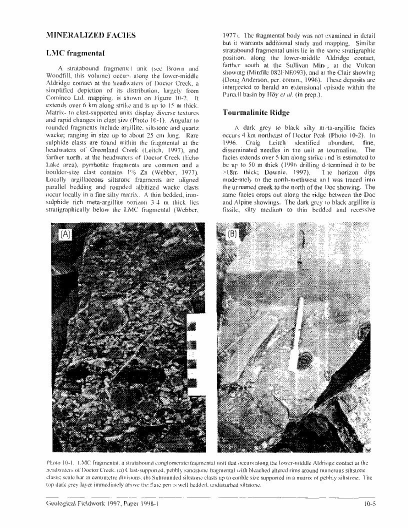
MINERALIZED FACII~:S 1977 a. The liagmen~al body was not ::samined in detail but it warlants addilional study and mapping. Similar stratahound fragmental units lie in the same stratiyraphic position, along the lower-middle 4ldridgc contact, farther south at lhc Sullivx Minx, at the Vulcan showng (Miniile 082l~NEO93), and ai the Clair showing (Dou< Anderson. per. comm., 1996). I’hesc deposits are interpreted to herald an e.\Lensional <episode within the Purcell basin by Htiy CI ul. (in prep,).
Tourmalinite Ridge
A dark grey to black silty m’.,ta-argillite facicr occurs 4 km northea,t of IIoctor Peak (Photo 10-2). In 1996. Craig Lcitch Idcntitied abundant, fine,, disscmmated needles in the unit as tourmaline. The facie eslends over 5 km along slrikc and is eslimated to bc ~117 to SO m thick (I 990 drilling ds~termined it to be :) I Xn; thick; Downic, 1997). ‘I !IC horizon dips Inwderatelq to the north-mrthwcst an.1 was traced inlo the unnamed creek to the n,xth of the I )oc showing. The same facie crops out alon% the ridge between the Dot and Alpine showing. The dark grcy IU black argillite is (issilc; silty medium to thin bedded and ~cessive
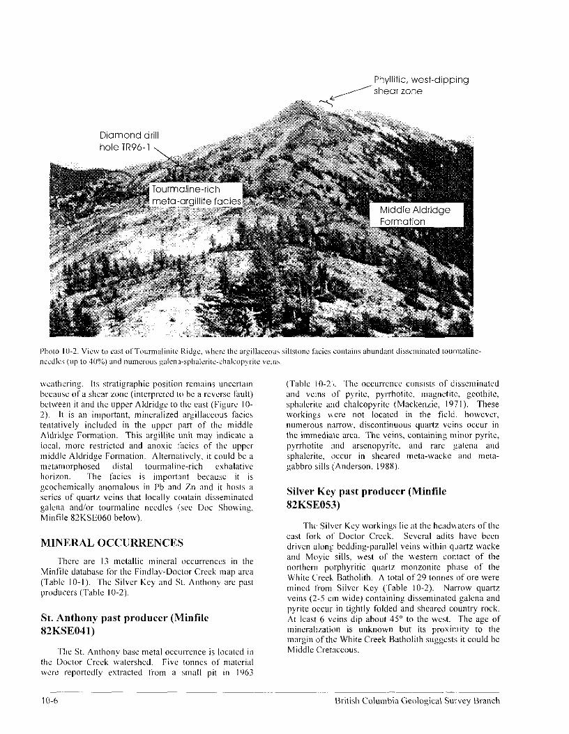
Phyllitic, west-dipping /shear zone
wcathwing. 11s stratigraphic position remains unccr&tn becnusc of a shear zone (interprctcd to be a rcvcrse fault) betwern it and the upper Aldridxe to the east (Figure IO- 2). It is an important, mineralized argillaceous facics tentatively included in the upper part of the middle Aldrid~c Formation. This nrgillire unit may indialc a local, more restricted and anoxic fxics oi the upper Iniddli: AIdridge Formation. Alternatively, it could bc a mstamorphosed distal tourmaline-rich erhalativc horizon. The iacics is important because it is ~cochemically anomalous in i’b and Zn and it ha& a series of quartr wins that locally contain disseminated ~alena and/or toummaline needles (we Dot Showing. Minfile 82KSEO60 below).
MlNERAL OCCURRENCES
.I’hcrc are I3 mclallic mineral ~~ccurr~nccs in the Minfile database for the Findlay-Dw:lor Cresk map area (T~ablc IO-I). ‘The Silver Key and 3. Anthony are par producers (Table 10.2).
St. Anthony past producer (Minfilc 82KSEO41 j
The St. Anthony base lmetal occ~rrcnce is Ioca~cd in the Doctor Creek watershed. Five tonnes 01 lmafcrial we’re reportedly extracted from a small pit in 1963
I O-6
(Table IO-2j. ‘She occur~‘cncc consists of disseminated and veins of pyrite, pyrrhotitc. magnetite, geothile, sphalcrite alld chalcopyritc (Mackenrie, 1971). These workings were not locawd in the tisld. howcvcr, ~numerous n;~rrow discontinuous quartz veins occur in the irmnediate area. The veins, containin: minor pyrite, pyrrhotite :md arsenopyrite. and rare ~alena and sphalcrite, occur in sheared meta-wacke and meta- gabbro sills i:Anderson, 1988).
Silver Key past producer (Minfile 82KSE05.3)
The Silver Ksy workings lie at the hcaduaters ofthe east fork 01’ Doctor Creek. Several adits lhavc been driven along bedding-parallel veins within quartz wacke and Moyie sills, west of the western contact of the norlhern porphyritic quarlz molzonirc phase of the White Creeh Batholith. A total of 29 tonnes of ore were mined from Silver Key (Table 10-2). Narrow quartz veins (2-S cm wide) containing disseminated galena and pyrite occur in tightly folded and sheared country rock. At lcast 6 veins dip about 48” to the west. The age of mineralization is unknown but its proximity to the margin ofthz Whire Creek Batholith suggests it could bc Middle Cretaceous.
British Columbia Geological Survsy Branch
Dot Showing (Minfile 82KSE060)
The Dot showing comprises a series of white, galena-bearing quartz veins cutting the dark grey tourmalinite needle-rich meta-argillite facies of the middle Aldridge Formation, on a ridge 7 km north of Doctor Peak (Figure 10-Z). It was originally explored by Kerr Addison Mines Ltd. in the 1970’s when they outlined a large Pb soil geochemistry anomaly (Kerr Addison, 1972). Angular blocks of vein material occur within the argillite felsenmeer along the ridge. The northwest-and lesser northeast-trending veins are up to 100 cm wide (average IO to 20 cm wide) and have been traced for about 100 m. Veins contain galena, lesser sphalerite and traces of chalcopyrite. Disseminated sulphides also occur in the host meta-argillite (Pautler, 1991).
Alpine/Rocky Top Property (Minfile 82KSEOSl)
The Alpine, also known as the Rocky Top property is hosted in rocks correlated with the Creston Formation, based on wavy bedforms, local abundant mudcracks, interbeds of argillite and faint green colour. It has been explored by Cominco Ltd. (Mawer, 1986) and Tech Exploration Ltd. (Pautler, 1991). A moderately, northwest-dipping sericitic phyllite shear zone hosts a shallow-dipping stratabound to slightly discordant zone of alteration comprising silicified, albitized and clay- altered rocks with disseminated pyrite and lesser sphalerite and galena. A semi-concordant boudinaged quartz-ankerite vein in the shear zone with disseminated pyrite and irregular blebs of sphalerite and minor galena ranges from 20 cm to 2 m thick.
The vein is cut by a series of younger, north- trending normal faults that offset portions of it by up to about 5 m. The zone is exposed in a bulldozer trench about 6 m high and 80 m long that has been mapped in
detail by Mawer (1986). The grade of the zone is 0.5% Pb and 0.6% Zn across a 3.5 m width and over the length, with a higher grade band containing 16 g&T Ag, 2.2% Pb and 3.7% Zn (Mawer, 1986).
MC showing (Minfile 82FNE107)
Two old hand trenches at the MC showing have recently been reinvestigated by Eagle Plains/Miner River Resources Ltd. A stratabound zone of banded and brecciated sulphides, locally with over 0.5 m of sphalerite, galena and pyrrhotite, is hosted in thin- bedded siltstone of the lower Aldridge Formation. Part of the occurrence displays “durchbewegung fexfure”, where pyrrhotite-rich sulphide contains rounded quartz fragments. Samples of typical sulphide material returned up 130.0 g/t Ag, 9.17% Pb and 6.27% Zn over 25 cm (Miner River Resources data). Rare colourless vuggy quartz veins cut the zone and are interpreted to be younger, Mesozoic features.
The showing was drilled in late 1997 by Miner River/Eagle Plains Resources. Seven short drill holes totaling 580 mares intersected several stratabound massive sulphide intervals of variable thickness (less than I cm). Assay results were not available during preparation of this report.
Streams draining the showing area are in the 99” percentile for the Nelson RGS survey for the 82F map sheet (Matysek ef a/., 1991) for the elements cesium, cobalt, copper, molybdenum, tin, tungsten, and zinc. The highest finite conductors detected for the entire Findlay Creek Area (Area 3; B.C. Ministry of Employment and Investment Open File 1996-23; lo-20 siemens; 7200 Hz, coplanar), interpreted to be narrow bedrock conductors, lie adjacent to the MC showing.
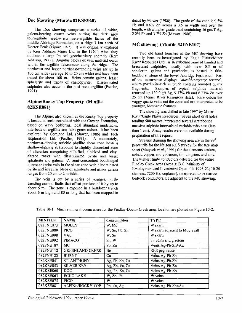
Table 10-l. Minfile mineral occurrences for the Findlay-Doctor Creek area, location at-e plotted on Figure 10-2.
MINFILE NAME Commodities 082FNE073 MOLLY W, MO 082FNE089 PICO W, Sn, Pb, Zn 082FNE090 VAL w. Sn
TYPE W skam W skam adjacent to Moyie sill W skam
92 1 PIMACO 1 Sn veins and g&ens ns Ag-Pb-Zn&Au
-2 pegmatite &,. yuly.l -” ‘:,;ns Ag-Pb-Zn
.--..---I1 1 ST.ANTHONY Ag, Pb, Zn, Cu Veins Ag-Pb-Zn n”rrr’nrnin ’ SILVERKEY Ag, Zn, Pb, Cu Veins Ag-Pb-Zn “LLKSb”b” DOC Ag, Pb, Zn, Cu Veins Ag-Pb-Zn 082KSE063 ECHO LAKE W, Zn, Pb W veins 082KSE075 PICO W W veins 082KSEOXl ALPINE/ROCKY TOP Ph. Zn. Ae Veins Ae-Ph-Zn+Au
Geological Fieldwork 1997, Paper 1998-l IO-7
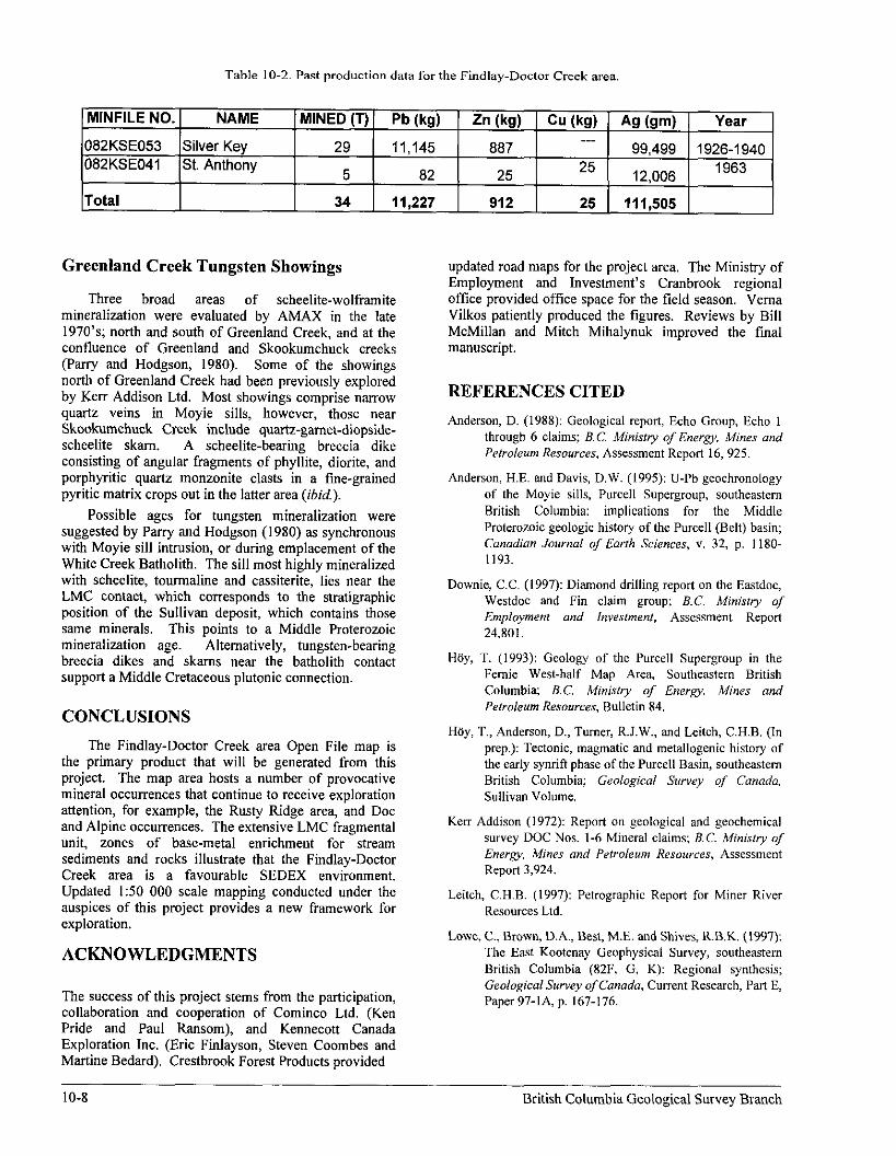
Table 1 O-2. Past Production data for the Findlay-Doctor Creek area.
MINFILE NO. NAME MINED (T) Pb (kg) Zn (kg) Cu (kg) Ag km) Year 082KSE053 Silver Key 29 11,145 ___ 887
99,499 1926-l 940 082KSE041 St. Anthony 5 82 25 25 12,006 1963
Total 34 11,227 912 25 111,505
Greenland Creek Tungsten Showings
Three broad areas of scheelite-wolframite mineralization were evaluated by AMAX in the late 1970’s; north and south of Greenland Creek, and at the confluence of Greenland and Skookumchuck creeks (Parry and Hodgson, 1980). Some of the showings north of Greenland Creek had been previously explored by Kerr Addison Ltd. Most showings comprise narrow quartz veins in Moyie sills, however, those near Skookumchuck Creek include quartz-gamet-diopside- scheelite skam. A scheelite-bearing breccia dike consisting of angular fragments of phyllite, diorite, and porphyritic quartz monzonite clasts in a tine-grained pyritic matrix crops out in the latter area (ibid.).
Possible ages for tungsten mineralization were suggested by Parry and Hodgson (1980) as synchronous with Moyie sill intrusion, or during emplacement of the White Creek Batholith. The sill most highly mineralized with scheelite, tourmaline and cassiterite, lies near the LMC contact, which corresponds to the stratigraphic position of the Sullivan deposit, which contains those same minerals. This points to a Middle Proterozoic mineralization age. Alternatively, tungsten-bearing breecia dikes and skams near the batholith contact support a Middle Cretaceous plutonic connection.
CONCLUSIONS The Findlay-Doctor Creek area Open File map is
the primary product that will be generated from this project. The map area hosts a number of provocative mineral occurrences that continue to receive exploration attention, for example, the Rusty Ridge area, and Dot and Alpine occurrences. The extensive LMC fragmental unit, zones of base-metal enrichment for stream sediments and rocks illustrate that the Findlay-Doctor Creek area is a favourable SEDEX environment. Updated I:50 000 scale mapping conducted under the auspices of this project provides a new framework for exploration.
ACKNOWLEDGMENTS
The success of this project stems from the participation, collaboration and cooperation of Cominco Ltd. (Ken Pride and Paul Ransom), and Kennecott Canada Exploration Inc. (Eric Finlayson, Steven Coombes and Martine Bedard). Crestbrook Forest Products provided
updated road maps for the project area. The Ministry of Employment and Investment’s Cranbrook regional office provided office space for the field season. Vema Vilkos patiently produced the figures. Reviews by Bill McMillan and Mitch Mihalynuk improved the foal manuscript.
REFERENCES CITED
Anderson, D. (1988): Geological report, Echo Group, Echo 1 through 6 claims; B.C. A4inislry of Energy. Mines and Petroleum Resources. Assessment Report 16, 925.
Anderson, H.E. and Davis, D.W. (1995): U-Pb geochronology of the Moyie sills, Purcell Supergroup, southeastern British Columbia: implications for the Middle Proterozoic geologic history of the Purcell (Belt) basin; Canadian Journal of Earrh Sciences, v. 32, p. 1180. 1193.
Downie, C.C. (1997): Diamond drilling report on the Eastdoc, Westdoc and Fin claim group; B.C. Ministry of Employment and Investment, Assessment Report 24,801.
HBy, T. (1993): Geology of the Purcell Supergroup in the Femie West-half Map Are& Southeastern British Columbia; B.C. Minisoy of Ener~, Mines and Peholeum Resources, Bulletin 84.
Hay, T., Anderson, D., Turner, R.J.W., and L&h, C.H.B. (In prep.): Tectonic, magmatic and metallogenic history of the early synritl phase of the Purcell Basin, southeastern British Columbia; Geological Survey of Canada, Sullivan Volume.
Kerr Addison (1972): Report on geological and geochemical survey DOC Nos. l-6 Mineral claims; B.C. Ministry of Energy, Mines and Petroleum Resources, Assessment Report 3,924.
Leitch, C.H.B. (1997): Petrographic Report for Miner River Resources Ltd.
Lowe, C., Brown, D.A., Best, ME. and Shives, R.B.K. (1997): The East Kootenay Geophysical Survey, southeastern British Columbia (82F. G, K): Regional synthesis; Geological Survey of Canada, Current Research, Part E, Paper 97-IA, p. 167-176.
10-S British Columbia Geological Survey Branch

Mackenzie, D.E. (1971): Geological survey, Ace claim group; B.C. Ministry of Enera, Mines and Peboleum Resources, Assessment Report 3,287.
Matysek, P.F., Jackamen, W., Gravel, J.L., Sibbick, S.J. and Feulgen, S. (1991): British Columbia Regional Geochemical Survey, Nelson (NTS 82F); B.C. Ministry of Eneqy, Mines and Petroleum Resources, BC RGS 30.
Mawr, A.B. (1986): Geological - soil geochemical report, Alpine Group; B.C. Ministry of Energy Mines and Petroleum Resources, Assessment Report 15,195.
McLaren, G.P., Stewart, G.G. and Lane, R.A. (1990a): Geology and Mineral Potential of the Purcell Wilderness Conservancy; B.C. Ministry of Energv. Mines and Petroleum Resources, Geological Fieldwork 1989, Paper 1990-1, p. 29-37.
McLaren, G.P., Stewart, G.G. and Lane, R.A. (1990b): Geology and Mineral Occurrences of the Purcell Wilderness Study Area; B.C. Minisfry ofEnergy, Mines and Petroleum Resources, Open File 1990-20.
Parry, S.E. and Hodgson, C.J. (1980): Greenland Creek Property; Internal Company Report, AMAX.
Pautler, J. (1991): Geological and Geochemical Assessment Report on the Dot Property; B.C. Ministry of Energy, Mines and Petroleum Resources, Assessment Report 21,275, 12~.
Reesor, J. E. (1996): Geology of Kootenay Lake, B. C.; Geological Survey of Canada, Map 1864-A
Reesor, 1. E. (1973): Geology of the Lardeau Map-area, east- half, British Columbia; Geological Survey OJ’ Canada, Memoir 369, 129 pages.
Reesor, 1. E. (1958): Dewar Creek Map-ares with special emphasis on the White Creek Batholith, British Columbia; Geological Survey of Canada, Memoir 292, 78 pages.
Rice, H.M.A. (1941): Nelson Map Area, East Half; Geologico[ Suwey of Canada, Memoir 228,86 p.
Smith, M. and Brown, D.A. (1998): Preliminary repot? on a Proterozoic (?) stock in the Purcell Supergroup and comparison to the Cretaceous White Creek Batholith, Southeastern British Columbia (82F116, 82WOl); in Geological Fieldwork 1997, B.C. Ministry of Employment and Invedment, Paper 1998s 1.
Webber, G.L. (1977): Geological report, Echo Group of I, 2,3 and 4 claims; B.C. Ministry of Energv. Mines and Petroleum Resources, Assessment Report 6,413.
Geological Fieldwork 1997, Paper 1998-l 10-9

10-10 British Columbia Geological Survey Branch