the evolutionary processes of border town development
TRANSCRIPT

International Journal of Developing Societies Vol. 4, No. 2, 2015, 26-47 DOI: 10.11634/216817831504666
ISSN 2168-1783 Print/ ISSN 2168-1791Online │© 2015 The Author(s) World Scholars, http://www.worldscholars.org
The Evolutionary Processes of Border Town Development: Case of Mwami Border Town in Zambia
Thomas Kweku Taylor1*, Chikondi Banda-Thole2, Siyamibila Mukuwa3
1,2Department of Urban and Regional Planning, School of Built Environment, Copperbelt University, Kitwe Zambia 3Department of Physical Planning and Housing, Chipata, Zambia
The growth of settlements at national boundaries in most developing economies in Africa has been perceived to be unplanned and uncontrolled. However, there is a school of thought that postulates that, such unique settle-ments evolve as a result of deliberate government actions or planned interventions as directed by land use plan-ners. History of settlement evolution and development indicate that, settlement evolution is dependent on many factors based on strategic geographical positions as well as other social, cultural, economic and political factors. The general assumption of most planners and geographers is that, border towns evolve and develop because of the movements that humans engage in cross border trading and the ease with which individuals create places of habitation. This study analyzed the growth of settlements at Mwami border. The study had three objectives which included: to identify the major factors affecting the growth of settlements at the border; to identify the de-terminants of growth of settlements at the border, and to examine the possible economic linkages of settlements growth at the border and District Capital of Chipata. The research utilized physical surveys, focus group discus-sions, interviews and questionnaires to gather the data. The conceptual proposition of the study was that there is no government intervention in settlement development processes at the border, hence the exhibition of manifes-tation of the “science of muddling through”. The factors that lead to settlement growth at the border are easy ac-cessibility to land (i.e., customary land), cross-border trade, farming and money changing. The determinants were the presence of different institutions, socio-economic infrastructure, i.e., schools, clinic, bank and easy procedure of approval of development plans. Lastly, the research revealed that, the growth of settlements at the border promoted and enhanced local economic development at the District capital of Chipata. Key Words: Border Town development, Evolutionary Processes, Mwami Border, Zambia
Introduction In today’s world geographies, settlement evolution-ary trends are fostered by a number of deliberate government economic and security reasons. Some of the reasons include decentralization by governments to reduce regional economic disparities in countries of the south (Maneepong, 2003); promotion of re-gional economic and social-cultural integration and cooperation and peripheral growth centres (See Wang, Cheng & Mo, 2014; Kudo, 2007; Perkmann & Sum, 2002a). Perkmann & Sum (2002a), stressed that the construction of cross-border regions have become a more or less explicit strategic objective planned by various social forces within and beyond border re-gions. In Thailand and Malaysia, it has been docu-mented that, “the concept of sponsored towns” evolved because of deliberate governments’ industri-al strategic development policies (Maneepong, 2003; Maneepong and Wu, 2004). There are other concepts of settlement evolution processes that have been em-
barked upon by governments, i.e., the growth pole theory which was first propounded by Francois Per-roux and later transformed into a regional planning concept (Perroux, 1950; Parr, 1973; Monsted, 1974) and the Agropolitan development concept (Fiedmann & Douglass, 1978; Friedmann, 1979; Ertur, 1984) have been seriously applied to deliberately create settlements that have grown and flourished to become cities of unimaginable dimensions. Corresponding author. Thomas Kweku Taylor, PhD, Department of Urban and Regional Planning, School of Built Environment, Copperbelt University, P. O. Box 21692, Kitwe Zambia. Email: [email protected]
This article is distributed under the terms of the Crea-tive Commons Attribution License, which permits unre-stricted use and redistribution provided that the original author and source are credited.

International Journal of Developing Societies 27
Other historical, social and economic and security factors that are perceived to assist in promoting set-tlement development in strategically selected loca-tions are the establishment of border posts by gov-ernments to provide security checks on cross-border movements between countries; establishment of mili-tary and police posts for security reasons; the creation of a farmstead emanating from agricultural activities; the pressure of a strategic position due to the pressure of a natural resource for man’s exploitation for socio-economic development.
The factors highlighted above have in many ways contributed towards the evolution of settle-ments throughout the world. Border towns’ develop-ment based on strategic government development policy implementation has become an emerging trend in most developed and developing countries (Perk-mann, 2002a; Paasi, 2005). Paasi (2005) postulated that, border areas have posed a significant issue in the academic discussions mainly after the collapse of the East-West “Iron Curtain” era. As such, there has been a methodological shift in research practice trend theorising border (Kallioras et al, 2010). In Europe, there are empirical cases of evidence indicating gov-ernments deliberate strategic decisions to promote regional integration through borderland industrial development and cooperation (Pongsawat, 2007, p.5). However, the concepts and principles seem to be well embraced and practised amongst the East Asian countries, i.e., Thailand, Myanmar, Laos, Singapore and China. In Africa, it appears the philosophy and principles have not been seriously reflected upon by economic development and policy makers even though regional institutional bodies like Economic Community of West African States (ECOWAS) Southern African Development Community (SADC) and Common Market for Eastern and Southern Africa (COMESA) (TradeMark Southern Africa, 2010) have signed communiqués to that effect. Nonetheless, there are some attempts by some academics to study borderland and border region integration and cooper-ation in Africa. Bonchuk (2012, p.295), also reiterat-ed that, though in Africa, the potential African re-gions or “Afregios” exist and can sustain African integration, inspite of persistent appeals and pressures from some segment of the academic community to imbibe this new thinking, the effort has not met with much success. Similarly, Aborne (2015), highlighted that although border studies constitute a well estab
lished cross-disciplinary sub-field in North America and Europe, Africa has thus far been marginal to the debate (See also Asiwaju & Adeniyi (1990). Iliasu (2014), researched on the role of cross-border trade and regional integration along Nigeria-Niger border along the Katsina-Marabi crossing. This study was an exploratory one to identify the main factors that pro-mote cross-border trading between the two countries and hence the subsequent realization of regional co-operation and integration. Similar studies have been done by Asiwaju (2011).
The article focused on the evolutionary processes of settlement development and growth at Mwami border in the Eastern Province of Zambia. The pa-per’s conceptual proposition is that the process of
settlement evolution is characterised by spatial de-velopment process depicting the Lindblom’s (1996)
“Science of Muddling Through” (see also Pena, 2007; Campbell and Feinstein, 1996) unlike the inte-grative process by nation states in Europe with Euro-pean Union (EU) spearheading the process and the North America Free Trade Agreement (NAFTA) with America and her neighbouring countries of Can-ada instituting committees to facilitate joint infra-structure development and implementation mecha-nisms to ensure that their strategic goals and vision are achieved. In the same vein, in South East Asia, bi-national co operations in border regional develop-ment projects are pursued.
Study Area The study focused on the growth of Mwami border region in Zambia. The main concern was on the evo-lution of the settlements, growth and sustainability and their inter-linkages, economically and socially. The main thrust of the research was on physical, so-cial, political and economic factors that contribute towards the evolution and growth of settlements at Mwami border region. Zambia with an estimated total area of 750,000 square kilometres and a popula-tion of 13,046,508 (CSO, 2010) is a landlocked coun-try in Southern Africa sharing common borders with 8 other countries, i.e., Angola, Botswana, Democratic Republic of Congo, Namibia, Malawi, Mozambique, Tanzania, and Zimbabwe (Kwesiga, et al., 2010).

28 T. K. Taylor, C. Banda-Thole and S. Mukuwa
Figure 1: Location of Study Area. Source: Generated by Mukuwa, 2013).
Zambia is connected to Malawi in the Eastern and Muchinga Provinces and shares its territorial bounda-ries with two Zambian rural towns namely, Lundazi and Chama and the Provincial Town of Eastern Prov-ince, Chipata. The two countries are linked by road network via Lundazi border, Mwami border in Chipata and railway network in Chipata (Njungu, 1998).
Mwami border is located between Zambia and Malawi in the East of Chipata (see Figure 1). It is located 12 kilometres away from Chipata town. Chipata is located between 32.5o and 33o East and 13.5o and 14o South and is one of the eight districts in the Eastern Province of Zambia. It is the provincial headquarters and shares an international boundary with Malawi in the east.
Chipata covers a land area of about 6,692 square kilometres and is about 600 kilometres away from Lusaka, the capital city of Zambia while it is only 110 kilometres from Lilongwe, the capital city of Malawi. The district, therefore, enjoys buoyant trade
and cultural ties with Malawi (Chipata Municipal Council, DSA, 2011). The population of Mwami border zone lives in villages and small communities (Chipata Municipal Council, DSA, 2011). There are twelve communities constituted by Mwami Trading, Dingaani, Mgabi, Ngocho, Lopo, Shabati, Mtheleza, Chimalo, Kachingwe, Mashanga, Simon Jere and Mwanabosauka. The whole border zone is character-ized by farming communities except the centre of Mwami where there are numerous economic activi-ties that are isolated from the business centre (Obidzinki, et al., 2007).
M’chinji is the first Malawian town from the
Zambian border and is 12 kilometres away from the Zambian border (Minde & Nakhumwa, 1998, p.7). The people of both sides share a similar language and culture. The informal trade involves the sale of Ma-lawian agricultural produce such as maize and pota-toes as well as soft drinks which is done in Malawian Kwacha, and are supported by effective informal money markets (ibid).

International Journal of Developing Societies 29
In 2010, Chipata-M’chinji railway line was launched (Ministry of Commerce Trade and Industry, 2011). This was evident of Zambia’s diversification of the
economy to boost the rural economy through enhanced transportation infrastructure (Kwesiga, et al., 2010). The railway line launched between Malawi and Zambia had mulitiple benefits at the border and in the long term was envisioned to improve the rural livelihoods and improve the rural settlements and communities at the border. This was to enhance the economies of District Capitals of Chipata in Zambia and M’chinji in Malawi and
overall contribute to the physical and socio-economic development of the two countries through an improved and easy means of transportation. The improved means of transportation of goods and services between the two countries was perceived to be a positive drive for people to be engaged in cross-border trade and the impact of trade to generate an economic value at the border and surrounding communities.
The regional disparities in endowments between Zambia and Malawi have resulted in people to be engaged in cross-border trade at the border. Pong-sawat (2007, p.57), made a similar statement when he reiterated that, locational differences are the root of many cross border cooperation initiatives such as United States of America and Mexico border or the Singapore - Johor Riau initiatives. It has also been observed that, as long as there is trade between the two countries, structural change will be inevitable on the physical environment and will affect the physical and economic growth of the settlements (Chipata Municipal Council, DSA, 2011). Cross-border trade at Mwami border region is carried out by business-men in the province and families, who produce agri-cultural products such as tobacco, maize and cotton.
The cross-border trading activities provide op-portunities for traders to gain new markets, source of supply, capital and labour although the opportunities are influenced by the level of economic development of both borders (Abd, et al., 2013). The emerging economic opportunities for traders to open new mar-kets prompt people to settle at the border and start building to serve the needs of the people and to fully operationalize their businesses.
Unlike strategic initiatives taken by various gov-ernments to develop the borderland regions to pro-mote economic development and regional integration and cooperation, the study area is under the absolute jurisdiction of the traditional authority of the leader-ship of Chief Mpezeni of the Ngoni people in Chipata District. The Planning Authority under the Chipata District Council has no statutory planning powers to undertake and enforce physical development control at the border. The traditional Authority’s absolute
control over land delivery and tenure system makes it very intriguing in terms of promoting and realizing the “transfrontier metropolis” or “urban system” as
postulated by Herzog & Sohn (2014). The cross-border economic activities influence
people to settle at the border because of a number of reasons that include a market that will command the economic environment of Mwami border region and will have the multiplier effects at the border and the District Capital. The opportunity of capital (funds) derived from the economic activities is perceived to attract a lot of people who are within and outside the surrounding communities to do business at the border region and subsequently settle. Settlement develop-ment at the border region is envisaged by the gov-ernment and the community around the area to grow as new economic prospects in trade are exploited by the people engaged in it. Therefore, there will be need to analyze the growth of settlements at the bor-der region based on the questions: What are the de-terminants of growth for the settlements at Mwami border? What are the possible economic linkages of settlement growth at the border?
Literature Review The term ‘border’ is often used synonymously with the terms boundary and frontier (New Thinking about Regional Planning, 2008, p.3). Afolayun (2013), de-fined borderlands as, land extending beyond the de-limited borders covering an area that marks a nation’s
sphere of influence. Settlement, on the other hand, can be differentiated as planned and unplanned, for-mal and informal, and comprising a range of housing types (South Africa Environment Outlook, 2006, p.239). A planned settlement is one that has a legal land tenure framework, and is characterised by the planned provision of services and infrastructure. On the other hand, unplanned settlements are settlements evolved as people settled in areas that were closer to employment opportunities. They occur in various locations (i.e., within planned settlements, an open land within an urban area, or in peri-urban areas). The peri-urban squatter settlements typically develop on the farms or smallholdings situated on the out-skirts of cities or towns (ibid). Informal settlements are defined as residential areas of the urban poor more often in cities of the developing world. They are found on public, private or customary land ac-cessed by invasion or developed against planning, building and ownership regulations (Abbort & Douglass, 2001, p.8). They lack basic social and in-frastructure services.
Rural settlements are areas characterized by farms, and lots of vegetation with sparse buildings.
30 T. K. Taylor, C. Banda-Thole and S. Mukuwa
This is the situation with most borderland areas in Africa. They exhibit features of ruralism in all as-pects, i.e., economy, physical environment and the sociological developments. In view of the disparity between the rural and urban settings, border town development tends to be influenced by numerous factors for its spatial, economic and social growth with Government policy approach perceived to be the main anchor (Perkmann & Sum, 2002a). Therefore, regional integration by countries to support cross-border trade among countries at the border is one major factor that contributes to the explanation of how the border develops and settlements around evolve. As a landlocked country, Zambia’s economic
development potential is closely linked to the fate and development of its eight bordering countries and other countries in the region (The World Bank Group, 2010, p.24).
The economic reforms and activities planned at the border region through regional cooperation have an impact on the development of border towns and may lead to settlement development at the border. A typical case is the Kasumbalesa border town in Zam-bia. This town has a one stop facility that was devel-oped between the Governments of Zambia and The Democratic Republic of Congo. Thus, regional inte-gration becomes important for Zambia to develop border regions and not considerably be trapped in a closed state but open with other states to improve on cross border trade and in the long run shape the phys-ical environment of the border. Zambia, through its membership in the Common Market for Eastern and Southern Africa (COMESA) and Southern Africa Development Community (SADC), recognizes the importance of regional integration to the develop-ment of the country’s economic infrastructure and to
boosting intra-regional trade and global competitive-ness (TradeMark Southern Africa, 2010). Regional integration by countries improves on regional infra-structure such as roads, and well coordinated institu-tional cooperation for economic integration to in-crease trade and private sector investment (The World Bank Group, 2010, p.24). The economic activ-ities spur development at the border which leads to the growth of border town development.
Cross-border developments can be observed in a variety of situations (van Den Broek & Smulders, 2013; Lundquist & Trippl, 2011; Maneepong & Wu, 2004). Lundquist & Trippl (2011, p.3) identified three stylized stages in the evolution of cross-border innovation systems, i.e., the weakly integrated sys-tems, semi-integrated system and strongly integrated. Collaborative innovations in a cross-border setting represent the last and most advanced stage of cross-border cooperation. It must be emphasized herein that, a significant number of studies have been made
to understand the philosophy and ideologies of gov-ernments in promoting border regions economic de-velopment and growth centres (Herzog, 1991; Perk-mann & Sum, 2007; Wang, Cheng & Mo, 2014; Her-zog & Sohn, 2014). Herzog (1991, 2014), studied and published some insights on the US and Mexico bor-derland region development. In Asia, numerous re-searchers have of late focused their attention on cross border developments to assess the success of inter government policies in promoting border region co-operation and integration. Some of the studies fo-cused on the Singapore-Johor Riau Growth Triangle, the Hong Kong and Shenzhen border region coopera-tion and integration, and the Tumen River Develop-ment Zone (See Thant, 1998; Wu, 1998; and Maneepong & Wu, 2004).
Maneepong & Wu (2004) indicated that, Thai-land like many other industrializing countries is con-cerned with over concentration of development in and around its capital city. It has been documented that, since 1970s, the Thai government has developed and implemented a number of policies at decentrali-zation of industries and urban growth away from Bangkok to regional centres and peripheral areas of the country (see also Perkmann & Sum, 2002a; Pong-sawat, 2007 and Lin, 2012). Thailand’s decentraliza-tion policy and sponsorship of border cities provides some intriguing insights into some of the innovative-ness on border creation and development. The towns of Mukdahan (in the northeast, bordering Laos) and Mae Sot (in the north, bordering Myanmar) are iden-tified as “sponsored towns” that have received con-siderable support and encouragement from the central government. Thailand’s government policies for en-couraging the economic development of border towns were driven by two main issues, i.e., the re-gional disparities within Thailand and the interna-tional context of the Southeast Asia sub-regional co-operation programmes. Similarly, in the process of sub-regional co-operation, border towns were recog-nized for their potential role and function as centres of economic activity (Maneepong, 2003; Lin, 2012).
The decentralization ideology seems to have been endorsed by the Chinese government when it initiated and implemented the border ports develop-ments in strategic regions in the country (Wang, Cheng & Mo, 2014). The Chinese Central govern-ment initiated a number of policies to increase the development of border port systems since the eco-nomic reforms were instituted in the late 1970s. Wang, Cheng & Mo stressed that, the systematic de-velopment by the Chinese government has promoted the further opening and sustainable development of border ports.
Another case of relevance is the Sarawak (Ma-laysia)-Kalimantan (Indonesia) border towns. Fol-

International Journal of Developing Societies 31
lowing the 1967 Basic Agreement between Malaysia and Indonesia, it was decided that the communities living in the immediate border areas on either side were to be allowed to cross the border for short, non-work related visits. To this effect, Serikin started as a small town in the early 1980s but it has now become an open-space hyper-supermarket and offers a variety of goods with relatively cheap prices (Thomas & William, 2010).
The growth of settlements is also closely tied to the political will by the governments to enter into bilateral agreements in joint infrastructure develop-ment projects. Some settlements have evolved due to the political will and power in the area which are called “political settlements” (Thomas & William, 2010). The expression, “political settlement” as it is used in recent development literature emphasizes the importance of powerful actors and informal institu-tions, which are often outside the scope of most de-velopment assistance models. The key elements of political settlements are powerful actors, operating in pursuits of their interests, leading to the establish-ment or reshaping of institutions to sustain the politi-cal settlement, including formal state institutions and informal arrangements (Thomas & William, 2010; Khan, 2009; see also Khan, et al., 1995).
.Similarly, Europe has experienced a tremendous transformation of borderland spatial and economic developments. There are more than over 70 cross-border regions operating under names such as, “Eu-roregions”, ‘Eurogios’ or working communities (Perkmann, 2002). The Eurogios started in the 1950s. The first Euroregion, the Eurogio was established in 1958 on the Dutch German border in the area of En-schede in the Netherlands and Gronau in Germany (ibid). However, it was in the 1990s that the continent experienced a large increase in the regionalization process which has been attributed to the Europeaniza-tion concept through the European Integration Policy (Prokkola, 2007; Perkmann & Sum, 2002b). The Eu-ropean cross-border regionalization process is mutual because it is both internally driven by regional au-thors and policy and externally driven by integration policy. In this respect, Brakman, Garretsen, van Marrewijk & Oumer (2010, 2011), highlighted on the abolition of the international borders which became internal European Union borders. The assumed trend is that almost the whole of Europe is experiencing transfrontier spatial planning and development. Typi-cal examples of such borderland regional develop-ment as a result of the European Union integration policy are the twin cities development programme on the Italy-Slovenia cross-border cooperation and inte-gration (Lipott, 2013); the transformation of cross-border regions in Scandinavia (Logfren, 2008); the cross-border communities development process be-
tween Austria and Slovakia (Haselsburger & Berne-worth, 2011).
In Africa, concerted efforts and coordination by regional integration and cooperation bodies such as Economic Community of West African States (ECOWAS), COMESA, and SADC have not taken serious initiatives by way of engaging in borderland regional spatial planning and development policies to motivate governments to break down the barriers and to facilitate infrastructure and investment develop-ment opportunities. Bonchuk (2014) reiterated this point when he stated that, “Though attempts at eco-nomic cooperation have been made at regional and sub-regional levels, results have not been encourag-ing. It has become imperative the African countries to adopt new models of economic cooperation and inte-gration”. However, Asiwaju (2011) highlighted the failure of African states to seriously cooperate to bridge the borders as potential for economic invest-ments and integration. Asiwaju stressed that, “In many cases in history, border relations between states have made a transition between two stages. In the first stage, there has been a conflictual relationship between the states, the borders may have been con-tested and the boundaries have acted as barriers. In the second stage, the relationship have changed and the boundaries have become used as bridges serving many positive functions as part of a mutually agreed process of regional cooperation and integration”
Asiwaju (2011, p.1). The second stage is where Afri-can governments have not been very vibrant in ensur-ing that political rhetorics are transformed into prag-matic realities.
Zambia with her eight (8) neighbours could go into serious border regions development agreements to promote trade and regional integration and cooper-ation hence, realizing the goal of small town develop-ing into transfrontier metropolises. The development of border towns become a risky and security concerns for governments hence the rigid and strict adherence to the regulatory measures handed down to her by her former colonial administrators. Zambia and Zimba-bwe have the opportunity to develop their borderland region using the common natural resources the Victo-ria Falls which is a significant tourism resource. Nonetheless, that opportunity has not been exploited. However, there are some examples that could be cit-ed as making strides to promote borderland spatial planning and development, i.e., South Africa and Mozambique corridor (Bowland & Otto, 2012; Mitchell, 2008; and Roodt, 2007). The Maputo De-velopment Corridor is the largest and most successful development initiative in the Southern African De-velopment Community (SADC) region. Interestingly, few years after the launch of the corridor, researcher made efforts to research on the impact on the devel-

32 T. K. Taylor, C. Banda-Thole and S. Mukuwa
opment of some of the towns at the borders. One sig-nificant study closely related to the topical issue of the article was the study by De Beer et al. in year 2001. De Beer et al. (2001) from a research on the impact of the Maputo Development Corridor (MDC) on the border towns of Ressano Garcia in Mozam-bique and Komatipoort (now Lebombo) in South Africa revealed that, though the populations of the towns were relatively small, i.e., 8,500 for Ressano and 12,500 for Komatipoort (now Lebombo), the population of the latter started growing faster. De Beer et al. reported that, Komatipoort’s population
growth rate was 5% per annum substantially higher than the national and provincial average, whilst that of Ressano Garcia was declining to show a town in depression (see also Roodt, 2007). The higher popu-lation growth was as a result of perceived economic growth and employment opportunities in the area (De Beer et al., 2001). In addition, the demand for com-mercial and residential land increased by 50% few years after the MDC was launched. It would have been expected that Ressano Garcia would have expe-rienced similar socio economic and infrastructure development dynamics. This was not the case. Ra-ther, Ressano Garcia started experiencing depression with unemployment estimated at 80%. The problem was that there was no localized stakeholder involve-ment in the strategic spatial development projects to attract investors in to the border region.
Conceptual Framework A schematic conceptual framework was evolved as possible explanation of the growth of settlements at the Mwami border region (see Figures 2, 3, 4 and 5). The conceptual postulations stem from the traditional location theory that supports the view that border regions are weakly developed within a closed econ-omy (Kallioras, et al., 2010). It is assumed that, gov-ernment forces such as trade policy, industrial policy, settlement policy etc., are considered as significant instruments which can facilitate or hinder the growth of settlement at the border. Pena (2007) postulated that, cross-border planning is approached as an insti-tution building process whose primary emphasis should be on the facilitation of collective action with regards to the shared natural, built and human re-sources. The conceptual framework constitutes four stages to show the stages of spatial growth of settle-ments based on some assumptions. The conceptual perceptions created seem to be in consonance with the thrust of a similar framework developed by Wang, Cheng & Mo (2014) (see Figure 6). The gov-ernment policy instruments in this study are per-ceived as exogenous influence that will determine the
extent of growth and development of settlements at the border region. The foundation of the schematic framework evolved from E. A. J. Johnson’s Market
Towns as Rural Growth Centres whereby he argued that, developing countries need to bridge the void between the ubiquitous villages and parasitic great cities by building a proper Loschian hierarchy of ur-ban centres which ranges from small towns to inter-mediate cities and national metropolis was consid-ered (Johnson, 1970).
The study applied the suggestions made by John-son on the town building elements, i.e., the creation of institutions such as the properly supervise markets, schools, banks, clinics, health centres and credit un-ions; coordination of public capital investments in public projects such as rice mills or storage facilities; infrastructure investments in electricity, road and railway construction that strengthens the locational advantages of small towns to promote entrepreneurs: and the creation of industrial estates and provision of incentives to encourage small scale modern manufac-turing activities in the rural areas to curb the urbani-zation process which tend to affect the delivery of services in the urban areas. In hindsight, the frame-work is seen to support the ideologies upheld on the decentralization philosophy by the governments of China, Thailand, Myanmar, Laos and Singapore in spreading out human settlements.
Stage One: Establishment of the Border Post The border was established in 1965 to facilitate cross-border trade between Zambia and Malawi. Mwami border evolved due to cross-border trade that occurred between Zambia and Malawi hence, gov-ernment thought of providing security by introducing Immigration and Custom officers as a measure of effecting control and security at the border. To that effect, government provided housing to the officers that were attached at the border. The assumptions underlying this schematic phase were: Cross-border activities between two countries; Road infrastructure not well developed; Indigenous Rural communities dotted around the border post; Mainly agricultural activities around the border region; Shops are created by the indigenous people at the border to provide needs in terms of groceries; Economic activities not intensified in the region apart from the agricultural activities (See Figure 2). Stage Two: Security Provision to enhance free movement of people promote trade
The main aim of the government at the border is to offer security so as to enhance the cross border trade and make sure that it maximizes revenue collection.

International Journal of Developing Societies 33
To successfully achieve this objective, there is need for government to improve the infrastructure at the border. The assumptions underlying this schematic phase were: The development of road infrastructure; the comparative and price differential between the two countries will prompt people to be engaged in cross-border trade; Cross-border social networks be-tween different members of communities at the bor-der; the bi-lateral cooperation between two countries intensified (see Figure 3).
Stage Three: Intensification of housing development and other institutional establishment
With the border security well developed and im-proved road infrastructure network between the two countries, cross-border trade is enhanced and pro-moted. It is assumed, at this stage that, people will be drawn from different parts of the province to be en-gaged in Cross-border trade using Mwami border. The spatial conditions of Mwami border region will determine whether people will stay at the border or not. The schematic conceptual framework shows a lot of yellow dots representing the individual households
acquiring land and building their individual house-holds at the border region (see Figure 3).
When cross-border trade is in operation, the con-cept assumes that, people will settle at the border. The institutions located at the border will also deter-mine the stay of people at the border. The assump-tions underlying this schematic phase were: the de-velopment of housing structures at the border will take effect by people engaged in cross-border trade; a school will be built to enhance the education stand-ards of the children at the border; a health post estab-lished to improve the health standards of people who will settle at the border; acquisition of land from the relevant authorities by the residents and people who are engaged in cross-border trade to build houses; the increase of economic activities at the border (agricul-tural activities and trading activities) as population grows; the increased economic activities are per-ceived as centripetal force that will draw a lot of peo-ple to be engaged in cross-border (the yellow dots in Figure 3 represent the individual houses built by peo-ple at the border).
Figure 6: Excerpt of the Evolutionary Process of Border Towns development by Wang, et al (2014)
Stage Four: Settlements growth and development The final stage assumes the growth of settlements at the border. This assumes that all the basic needs and the services have been provided at the border and this
sets the pace for development and growth of settle-ments at the border. The assumptions underlying this schematic phase were: Increase improved housing facilities; Increase of residents due to social net-works; Increase security; Health facilities available; Market size increase.
Policies
Geopolitical Environment demand for socio economic exchanges
Border Ports or towns open-ing up
Infrastructure Exports processes zone border Economic cooperation zone
Logistics for Manufacturing

34 T. K. Taylor, C. Banda-Thole and S. Mukuwa
Housing
Area
Housing area for
Customs and Immi-
gration officers
M’chinji Mwami
Border
Border lines
Road Infrastructure not well devel-oped
Bilateral co-operation not intensified
M’chinji Border Post B Mwami Border Post
Zambia Malawi
Figure 2: Conceptual Perception of initial Spatial Development. Source: Developed by Authors

International Journal of Developing Societies 35
Housing area for Cus-toms and Immigration officers
Housing Area
Small scale market devel-oped to carter for needs of border personnel
Road Infrastruc-
ture improved
and developed
Mwami border Post M’chinji
Small informal Market de-veloped to carter the needs of border post personnel M’chinji Border Post
Mwami Border Post
Zambia
Malawi
Figure 3: Conceptual Perception of Spatial Development (Increase in activities at the Border), Source: Developed by Authors

36 T. K. Taylor, C. Banda-Thole and S. Mukuwa
Housing Area Housing
Area
Market
Market
Mwami Border Post
M’chinji School
School
Mwami Border Post M’chinji Border Post
House improvement and development takes root
Clinic Police post
Institutions
Figure 4: Conceptual Perception of Spatial Development (Expansion of Border housing and institutional development activities). Source: Developed by Authors

International Journal of Developing Societies 37
Housing Area
Housing Area
Market
Market
School
School
Housing Area
Housing Area
Zambia
Malawi
Institutions
Police post
Clinic
Improved Road connecting Zambia and Malawi
Figure 5: Conceptual Perception of Spatial Development (Increase in spatial development activities settlement growth experienced)Source: Developed by Authors

38 T. K. Taylor, C. Banda-Thole and S. Mukuwa
Settlement growth starts with the construction of so-cio-economic infrastructure at the border, i.e., clinics, schools, etc. This acts as centripetal force and draws a lot of people who are engaged in cross-border trade. With time, the traders will begin to put up structures as their permanent residential houses which in the long run will lead to the emergence of settlements.
Therefore, government’s intervention at the bor-der region development in this concept is realized to be of great importance in the explanation of growth of settlements. There are only few studies that men-tion the spatial effect of integration, especially at the border. According to Niebuhr and Stiller (2002), the spatial closeness of border regions opens the doors to foreign markets and thus affecting the resource allo-cation of those regions. Despite the lack of founda-tion, spatial effect is widely understood in the context of trade liberalization, as the increase of production factor mobility and reallocation, facilitated with the opening of the cross-border markets, changes in poli-cy and improvements of technology (Brulhart, 2011, 2010). However, spatial effects only occur with a certain number of preconditions for a favourable en-vironment, such as a sufficient factor endowment in terms of labour, communication and transportation infrastructure as well as a high degree of mutual co-operation between the two neighbouring nations. From the conceptual framework, it could be suggest-ed that, the economic activities generated at border region will lead to improved transportation infra-structure, agricultural development, housing devel-opment and cross-border infrastructure that will spur the growth of settlements around the border region. This will call for strategic land use planning and so-cio-economic planning at the border region to ensure development control.
Research Methodology This was an exploratory and qualitative study to gain insights on the growth of settlements at the border region of Mwami. The observation of the pattern of physical growth, obtaining of the historical data of its evolution, focus group discussions, survey data col-lection which comprised administering of question-naires and interviews were used. Lastly, grounded theory method was used to capture data on the growth of settlements at the border using the sche-matic conceptual framework. The total population of Mwami Border region at the time of the research was 24,718. The figure constitut-ed 12,248 males and 12,470 females with an estimat-ed number of 4,270 households (Chipata DSA, 2011). The sample of 89 households was selected using stratified simple method because of the varia-
tions in economic occupations of people at the border (i.e., farming, cross-border trade and money chang-ing). The data collection procedure was the admin-istration of questionnaires to institutions at the bor-der, Management of Chipata Local Authority and individual households at Mwami Border. The other methods used for this study were interviews, focus group discussions and direct observations, particular-ly, on the physical growth and projects that are taking place at the border. The secondary data was the in-formation gathered from published institutional doc-uments on the spatial context of the border or the growth of settlements at the border.
The questionnaires administered focused on the factors of growth of settlements, determinants of growth of settlements, and the possible economic linkages and population structure at the border. The institutional questionnaire was used to generate in-formation on the historical evolution of the settle-ments at the border, their role at the border and their contribution towards the growth of settlements at the border. The household questionnaire for respondents at the border was to ascertain information on how physical development projects are carried out, who is in-charge of land acquisition, who approves develop-ment plans and to establish the diversity of economic activities the people at the border are engaged in.
Results and Discussions Historical background on the evolution of Mwami Border Town The border was established in 1965 to facilitate cross border trade between Zambia and Malawi. Mwami border evolved due to constant trade that occurred between Zambia and Malawi hence, government thought of providing security by introducing Immi-gration and Custom officers for revenue collection (Customs and Immigrations, 1968). Government pro-vided housing to the officers that were attached at the border to collect revenues on behalf of government. Mwami border is within the bounds of the Paramount Chief Mpezeni Area and Authority, hence, any de-velopment in the area is under his authority. The Par-amount Chief is in-charge of approval of every de-velopment in the area. Permits for building develop-ment are issued at the secretariat of the chieftaincy. With the regular trade between Zambia and Malawi, settlements began to spring up around the border re-gion due to easy accessibility to land for housing development. The poor prefer to live in the informal settlements where they build their houses with no titles to land or official permission and depend on informal economy (Hall & Pfeiffer, 2000, p.6). It was
International Journal of Developing Societies 39
realised from the survey that, the historical growth of the settlement was due to informal economic activi-ties at the border which comprised of money chang-ing, street vending of agricultural goods, and public transport from Mwami border to Chipata’s Central
Business District (taxi drivers, who ferry passengers who come from Malawi with goods). The informal economic activities supported the people to start building their houses with no reference to the obser-vation of town and country planning standards. The easy access to land has greatly contributed to the rap-id expansion and growth of the settlement. Thus, the pattern of growth of housing development from 1965 to 2010 indicated that, housing development has in-creased tremendously, since 1965. Between 1965 and 1995, there was an increase of 93.93%. However, between 1995 and 2000, it was 102.73% increase. Significantly, between 2000 and 2010, the increase was 105.68%. The trend indicates that, there are more people being attracted to the border region. The pos-sible implications are that, the area is growing at a fast pace.
The schematic conceptual framework was evalu-ated to ascertain the linkage of the historical devel-opment of Mwami borderland and how the settle-ments have evolved from the time it was established. The conceptual postulations of Figure 4, shows a lot of open spaces with few houses for the border offic-
ers at the time the border was established in 1965. The border was surrounded by agricultural land with sparse settlements around it. Farming was the only source of income for the residents at the border. Sub-sistence farming was dominant since there were no commercial farmers who had settled, at the time the border was established (Chipata Municipal Council, DSA, 2006). There were no economic activities or any planned infrastructure apart from the houses which the government built for her officers managing the border post.
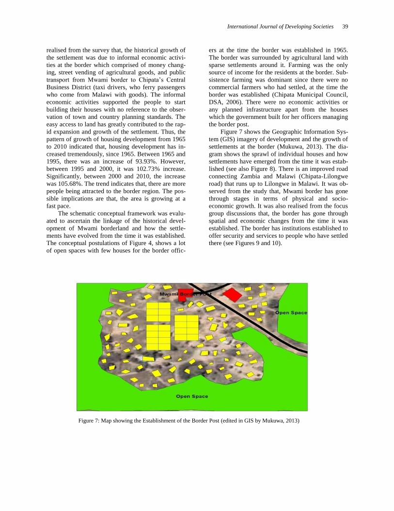
Figure 7 shows the Geographic Information Sys-tem (GIS) imagery of development and the growth of settlements at the border (Mukuwa, 2013). The dia-gram shows the sprawl of individual houses and how settlements have emerged from the time it was estab-lished (see also Figure 8). There is an improved road connecting Zambia and Malawi (Chipata-Lilongwe road) that runs up to Lilongwe in Malawi. It was ob-served from the study that, Mwami border has gone through stages in terms of physical and socio-economic growth. It was also realised from the focus group discussions that, the border has gone through spatial and economic changes from the time it was established. The border has institutions established to offer security and services to people who have settled there (see Figures 9 and 10).
Figure 7: Map showing the Establishment of the Border Post (edited in GIS by Mukuwa, 2013)

40 T. K. Taylor, C. Banda-Thole and S. Mukuwa
Figure 8: Some Housing development at Mwami Border Source: Photo taken by Mukuwa (2015)
Ethnicity of Mwami Border From the focus group discussion, it was revealed that, people who settled at the border were the Ngonis, Chewas, Nsengas and Tumbukas. The most dominant tribe at the border is Ngoni of Chipata. The discus-sion further revealed that, a lot of Ngonis settled at the border because it was easier for them to acquire land from the chief being the main subjects under his Chiefdom. The occupation of people at the border region was predominantly farming which was prac-tised by the indigenous Ngonis. The other economic activities generated at the border started emanating as cross border trade was recognized to be an important activity to support the border residents. Hence, peo-ple became involved in cross-border trade. It was revealed that, it is cross-border trade that pulled peo-ple from different parts of the province to settle at the border to exploit the opportunities. This implies that the Nsengas, Chewas and Tumbukas who have set-tled at the border migrated into the area for improve-ment in social mobility.
Institutions Established at the Border There are 8 institutions that actively play an effective roles at the border, i.e., Zambia Police Service that offers security and protection to the residents (see Figure 9) Drug Enforcement Commission (DEC) whose role is to ensure that no illegal drugs are im-ported into or exported out of the country, Customs and Immigrations whose responsibility is to oversee to the collection of revenues through duties from cross border trading activities (see Figure 10), Road Transport and Safety Agency whose responsibility is to check on the safety of vehicles imported into Zam-bia, Invest Trust Bank provides the quality banking services to the people of the border region, Common Market for Eastern and Southern Africa (COMESA) is to facilitate easy movement of people and vehicles at the border and ensure food security through Sim-plified Trade Regime Policy and Police Service whose role is to ensure maximum security and pro-tection for the inhabitants of the border region. The existence of the institutions at the border provides confidence and trust in people to settle at the border.

International Journal of Developing Societies 41
Figure 9: Police Post established at the Mwami Border by the Government of the Republic of Zambia . Source: Photo taken by Mukuwa (2015)
Figure 10: Customs and Immigration Office at the Border Source: Photo taken by Mukuwa (2015)
The presence of the institutions provides the security that makes residents very comfortable to invest in the area. Once a prospective developer has the money to pay for the plot of land, the Secretariat of the Tradi-tional Chiefdom is willing to provide the land. Land acquisition and housing development From the survey, it was further ascertained that, there are external and internal factors that lead to settle-
ment development at the border. The internal factors leading to settlement growth at the border was per-ceived to be the ease of accessibility to land by the sole custodians of it. The survey further revealed that, the only requirement to obtain a plot at the border for residential building was money. The external factors leading to settlement growth at the border are eco-nomic activities which draw a number of people from different parts of the Province to engage in business at the border.

42 T. K. Taylor, C. Banda-Thole and S. Mukuwa
Figure 11: Chalets being constructed by Private Investor Source: Photo taken by Mukuwa (2015)
Socio-Economic Infrastructure The socio-economic infrastructure found at the bor-der includes two (2) primary schools, i.e., a govern-ment and a community school, one (1) clinic and one (1) bank. The provision of infrastructure at the border induced a lot of people to settle as they are assured of good health and improved education to their children. Nsanjera Primary School was built in the year 2000 and has a capacity to accommodate people from grade 1 to grade 9. It has 10 teachers and has 456 pupils with 294 boys and 162 girls. The Community School was built in the year 2009 by the communities of Mwami Border region and can only accommodate pupils up to grade seven. The community school is managed by 3 community volunteers of Mwami Bor-
der Community. The number of pupils at Mwami Border Community School is not permanent as the figure keeps on changing daily due to inconsistency of pupils. The survey revealed that, pupils do not regularly attend classes at the school. It was also not-ed from the survey, that due to poor conditions of the physical infrastructure of the Community School, the community teachers are not motivated enough to provide the quality service to pupils in the school. Nevertheless, the Ministry of Education through the District Education Board of Chipata work hand in hand with the Mwami Border Community School and supplies them with all the curricula materials. Thus, this has made people to settle at the border because of the assured basic education service delivered to their children.
Figure 12: Premises of Investrust Bank at the Border Source: Photo taken by Mukuwa (2015) .

International Journal of Developing Societies 43
The Investrust Bank was established in 2006 with an objective to serve as a financial safety and security at the border. Being the only bank established at the border, all the institutions doing business at the bor-der, bank with it. The survey also revealed that there are indigenous businessmen at the border who have opened accounts with the bank. Although, the branch is small, it has met the targets set for its establishment
in the area. Plans are underway for expansion in terms of service provisions and activities done at the border. Sources of Employment The sources of employment at the border are farming, cross-border trade and money changing.
Figure 13: Showing Part of Adamson Lodge at the Border Source: Photo taken by Mukuwa (2015).
Figure: 14: Part of Adamson Lodge at the Mwami Border Source: Photo taken by Mukuwa (2015)

44 T. K. Taylor, C. Banda-Thole and S. Mukuwa
The most prevalent source of employment at the bor-der is cross border trade. Though farming is done, it is basically at subsistence level. This implies that, at least at the end of the season, with good rainfall pat-terns, farmers are able to realise some income to sus-tain their family needs. From the survey, only 5 farmers were engaged in commercial farming with the rest engaged in subsistence farming. The sizes of the farms for the subsistence farmers range between 2 hectares and half acre, while the commercial farmers are able to access farm areas ranging between 8 hec-tares and 20 hectares. Conclusion The emerging trend of dynamism of settlement de-velopment propagated by governments in some de-veloped and developing economies seem to be lack-ing in the case study area of Mwambi-M’chinji bor-der crossing between Zambia and Malawi. One would have expected that with the two governments being members of the SADC and COMESA, they would have deliberately initiated economic and phys-ical development strategies to develop their border regions to realise the regional integration and cooper-ation agenda. Rather, cross border trading activities though on the increase, no efforts have been made to promote physical planning and development that could streamline land use planning to direct and shape the forms and images of the towns of Mwami and M’chinji within the framework of a harmonised
borderland region. The usual ubiquitous villages con-tinue to spring up and expand without any town plan-ning guidelines to control development.
The fact that the area falls under the jurisdiction of the leadership of Chief Mpezeni of the Ngoni peo-ple of Chipata reiterates the point that, the rate of expectation of economic and physical transformation of the regional borderland areas will be slowed down. Unlike the other developing economies in the South Eastern Asia, i.e., Thailand, Myanmar, Laos, Singa-pore, as well as Europe’s Eurogios where there is
political will and determination of governments and private economic institutions including Small and Medium enterprises to initiate regional integration and cooperation strategies to develop industries and manufacturing in line with governmental policies to create growth centres that are to grow into big me-tropolis.
Mwami-M’chinji border towns have the poten-tial to develop into a border region whereby efforts of the Governments of Zambia and Malawi could trig-ger the physical and economic development process. The concepts propagated on the basis of Rural Mar-ket Centres seem to have been the common place phenomenon whereby few institutions have been
established including banks, clinics, police post, im-migration centre to control the movements and activi-ties of cross border traders.
The literature reviewed highlighted some serious governmental protocols and agreements between na-tion states to ensure that trans-frontier metropolitan communities are achieved over time. The developed economies are seriously doing everything possible to transform their economies through the process of revolutionizing and subsequently transforming their nation states. In Europe, it speculated that over 70 cross border regions have been developed. The com-mon trend is that, countries are encouraged by the European Union to facilitate and promote cross-border cooperation and integration in line with the concept of globalization, digitization and economic integration. Contrary, in Africa and in particular Zambia and Malawi, it appears the governments have not embraced the concept and ideology of borderland regional development and spatial planning. This un-certainty in decision making and firmness in the be-lief of the regional cooperation and integration con-cepts and principles slows down the globalization process through the borderland development agenda. In order for the two countries to realize their goal of borderland regional cooperation and integration through joint spatial planning and development of projects it is envisaged that there should be political will on the part of the two governments of Malawi and Zambia to invest in the borderland regional infra-structural development programme. This will require that institutional structures for physical planning and development are put in place.
Secondly, the two countries’ cross-border com-missions should be seriously activated to redefine common goals, objectives and strategies on spatial planning and development to promote and facilitate both economic and socio-cultural cooperation and integration. The issue of socio-cultural and land ten-ure and land delivery systems require that the tradi-tional chiefs are engaged in the consultations and participatory processes. The role of the traditional chiefs is very paramount in the vision of the border-land regional development process because of them being the custodians of the land of the area.
Finally, it must be stated that, the potential for both countries to realize a borderland regional com-munity based on cooperation from the two govern-ments is a reality that will require both governments through their appropriate ministerial institutions to seriously work together on common goals and strate-gies especially on the spatial planning and develop-ment of appropriate projects such as roads, electrici-ty, water and other social infrastructure facilities such as schools and hospitals. Reflecting on the govern-ments’ role in the provision of the infrastructure fa-

International Journal of Developing Societies 45
cilities will require the creation of economic condi-tions that will attract entrepreneurs to invest in indus-trial and real estate projects that will make the area become attractive to people from both sides of the border region to migrate. This in effect will ease pressure on the main cities of Lusaka, Ndola, Kitwe and Livingstone which are experiencing serious ur-banization problems. The border region development issue discussed on the case study reiterates the point that the government of Zambia should seriously re-flect on the decentralization policy and its effective implementation strategies.
References Abbort, J., & Douglass, D. (2001): A methodological
approach to upgrading of Informal Settlements in South Africa, Pretoria: Water Research Commission. Pretoria.
Abd, H. A., Junaenah, S., Noor, R. A., Mohd, Y. A., and Ong, P. L. (2013): Informal Cross-Border Trade Sarawak (Malaysia)-Kalimantan (Indonesia): A Catalyst for Border Community's Development. Asian Social Science, 9 (4), 167-171.
ABORNE (2015): African Borderlands Research Network Brochure Publication, www.aborne.org aborne-publication.html. Accessed and retrieved 10th May 2015
Adams, N., Cotella, G., & Nunes, R. (eds.) (2011): Territo-rial Development, Cohesion and Spatial Planning: Building on EU Enlargement. Taylor and Francis Group.
Afolayun, A. A. (2013): Trans-Border Movement and Trading: A Case Study of a Borderland in Southwest-ern Nigeria.
Asiwaju, A. I. (2011): Overarching Inter- Governmental Frameworks: Comparative Reflections on Nigeria's Tested Mechanisms, Concordis Briefing 1, June 2011.
Asiwaju, A. I. & Adeniyi, P.O. (1990): Borderlands in Africa: A Multidisciplinary and Comparative Focus on Nigeria and West Africa. Lagos: University of Lagos Press
Bonchuk, M.O. (2014): Nigeria-Cameroon Borderland: Prospects of Economic Cooperation and Integration, American Journal of Social Issues and Humanities, vol. 4, Issue 2, March 2014, pp.29-111, ISSN: 2276-6928
Bonchuk, M.O. (2012): Academic Research in Borderlands Studies: The Challenge of the Trans-national Para-digm, American Journal of Social Issues and Humani-ties, vol. 2(5), September 2012, pp.294-306, ISSN: 2276-6928.
Bowland, C. & Otto, L. (2002): Implementing Develop-ment Corridors: Lesson from the Maputo Corridor,
South African Foreign Policy and African Drivers Programmes August, 2012.
Brakman, S., Garretsen, H., van Marrewijk, C. & Oumer, A. (2010): The Border Effect of EU Integration Evi-dence for European Cities and Regions
Brulhart, M. (2011): The Spatial Effects of Trade Open-ness. DG Regional Policy Seminar, Brussesls, 22 March 2011.
Brulhart, M. (2010): The Spatial Effects of Trade Open-ness: Survey. Research Paper Series (Research Paper 2010 10, Globalization, Productivity and Technology, The University of Nottingham
Brakman, S., Garretsen, H., van Marrewijk, C. & Oumer, A. (2011): The Posaitive Effect of EU Integration, CESifo Working Papers No. 3335, Category 8: Trade Policy, January, www.cesifo.org/wp
Campbell, S. & Fainstein, S. (eds.) (1996): Readings in Planning Theory. Malden, MA: Blackwell Publishers
Central Statistical Office (2011): 2010 Census of Population and Housing. Lusaka: Republic of Zambia.
Chipata Municipal Local Authority (2006): Chipata District Situational Analysis. Chipata: Chipata Municipal Local Authority.
Chipata Municipal Local Authority (2011): Chipata District Situational Analysis. Chipata: Chipata Minicipal Local Authority.
De Beer, G., Mmtali, R., & Arkwright, D. (2001): Spatial Development Initiatives: Some Lessons of Experience for the Common Market for Eastern and Southern Af-rica, COMESA, Lusaka.
Ertur, O. S. (1984): A growth Centre Approach tp Agropol-itan Development, HABITAT INTL., vol.8, No. 2. pp. 61-72.
Friedmann, J. (1979): Basic needs, Agropolitan Develop-ment and Planning from Below, World Development, June, vol. 7(6), 607-613.
Friedmann, J. & Douglass, M. (1978): Agropolitan Devel-opment: Towards a New Strategy for Regional plan-ning in Asia, in Lo, F.C. & Salih, K. (eds.) (1978): Growth Pole Strategy and Regional Development Pol-icy: Asian Experience and Alternative Approaches. Oxford England: Pergamon.
Hall, P., & Pfeiffer, U. (2000): Urban Future 21: A Global Agenda for Twenty-First Century Cities. London: Taylor and Francis Group, ISSN 0 415 24075 1.
Haselsberger, B. & Benneworth, P. (2011): Cross-border Communities or Cross-border Proximity? Perspectives from the Austrian Slovakian Border Region. In N. Adams, G., Cotella and R. Nunes (eds.) Territorial Development, Cohesion and Spatial Planning: Build-ing on EU Enlargement (pp. 229 254. Taylor and Francis Group.
Herzog, L. A. (1991): Cross-Border National Urban Struc-ture in the Era of Global Cities: The US Mexico Transfrontier Metropolis, Urban Studies, vol. 28, No.4, pp.519-533.

46 T. K. Taylor, C. Banda-Thole and S. Mukuwa
Herzog, L. A. & Sohn, C. (2014): The Cross Border Me-tropolis in a Global Age: A conceptual Model and Empirical Evidence from US Mexico and European Border Regions, Global Society, September.
Iliasu, W (2014): Toward a regional integration along Ni-geria-Niger border: A Case Study of Katsina-Maradi Crossing, The Business and Management Review, vol., 4, No. 3, pp.134-143.
Kallioras, D. Petrakos, G., Topaloglou, L., & Tsispa, M (2010).: The Determinants of Growth in EU Border regions, 50th ERSA Congress, 17th-23rd August 2010.
Khan, M. (2009): Political Settlements and the Governance of Growth-Enhancing Institutions. London: Routledge.
Khan, M., Harriss, J., Hunter, J., & Lewis, C. (1995): State Failure in Weak States: A Critique of New Institutionalist Explanations. New Institutional Economics and Third World Development, 10-55.
Kudo, T. (2007): Border Industry in Myanmar: Turning the Periphery into Centre of growth. (Institute of Develop-ing Economies: IDE Discussion Paper No. 122.
Kwesiga, F., Bhebhe, T., Mukungu, A., Gisela, G., Matila, M., Arcelina, Y., (2010): African Development Bank Group. 2011-2015 Country Strategic Paper.
Lo, F.C. & Salih, K. (eds.) (1978): Growth Pole Strategy and Regional Development Policy: Asian Experience and Alternative Approaches. Oxford England: Per-gamon.
Lofgren, O. (2008): Regionauts: The Transformation of Cross-border Regions in Scandinavia, European Urban Regional Studies, 15(3), 195 209.
Lindblom, C. E. (1996): The Science of "Muddling Through" in Readings in Planning Theory (eds.) Scott Campbell and Susan Fainstein. Malden, MA: Black-well Publishers.
Lin, S. (2012): Dynamics of Cross border industrial Devel-opment in Mekong Su region: Case of Study of Thai-land, Singapore Journal of Tropical Geography, 33, (2), pp. 273 274.
Lipott, S. (2013): Twin Cities: Cooperation beyond Walls. The Case of Cross Border Cooperation between Italy and Slovenia.
Lundquist, K J., & Trippl, M. (2011): Distance, Proximity and Types of Cross Border Innovation Systems: A Conceptual Analysis, Regional Studies, 1-11. doi:10. 1080/00343404.2011.560933
Maneepong, C. and Wu, C. T. (2004): Comparative Bor-derland Developments in Thailand, Journal of South-east Asian Economies, vol., 21, No. 2, August
Maneepong, C. (2003): Policy Thinking and Impact of Economic Promotion in Border Towns, Thailand. Tin-jauan (2002-2003) 5.
Minde, I. O. & Nakhumwa, T. O. (1998): Unrecorded Cross-Border Between Malawi and Neighbouring Countries. Blantyre: AMEX International Inc. vol. 90.
Ministry of Commerce Trade and Industry, M. (2011): Strategic Plan 2011-2015. Strategic Planning.
Mitchell, J., (2008): The Maputo Development Corridor: A case study of the SDI Process of Mpumalanga, Taylor and Francis Online, 27th February 2008)
Monsted, M. (1974): Francois Perroux's Theory of Growth Pole and Development Pole: A critique, Antipode, vol.,6 issue 2, pp.106-113 July 1974.
Mukuwa, S. (2013): Analysis on the growth of Settlements at the border: Case of Mwami Border in Zambia. Un-published Dissertation for the award of B.Sc. Urban and Regional Planning, Department of Urban and Re-gional Planning, School of Built Environment, Cop-perbelt University, Kitwe Zambia.
New Thinking about Regional Planning, 2008: Regions: The Voice of the Membership. Regional Studies Asso-ciations The International Forum for Regional Devel-opment Policy and Research. ISSN: 1367–3882.
Niebuhr, A. & Stiller, S. (2002): Integration Effects in Bor-der Regions: A survey of Economic Theory and Em-pirical Studies, discussion paper, No. 179, HWNA Hamburg: Hamburg Institute of International Econom-ics.
Njungu, J. (1998): Tackling HIV/AIDS in rural Zamba from a developmental perspective. 12th International Aids Conference.
Obidzinki, K., Anrianto, A., & Wijaya, C. (2007): Cross-border timber trade in Indonesia, International Forestry Review, 9 (1), 7.
Paasi, A. (2005): Generations and the Development of Border Studies, Geopolitics, 10(4), 663-671.
Parr, J. B. (1973): Growth Polees, regional development and central place theory, Papers of regional science Association, vo., 31, Issue 1, pp.173-212.
Pena, S. (2007): Cross-Border Planning at the US- Mexico Border: An Institutional Approach, Journal of Border-land Studies, vol., 22 No. 1 Spring
Perkmann, M. & Sum, N-ling (2002): Globalization, re-gionalisation and Cross-Border Regions: Scales Dis-course and Governanace. In Globalization, regionali-zation and Cross-Border Regions, edited by M. Perk-mann and S. Ngai-Ling. Houndmills: Palgrave Mac-millan
Perkmann, M. & Sum, N-ling (eds.)(2002): Globalization, Regionalization and Cross- Border Regions. Houndmills: Palgrave Macmillan.
Perkmann, M. & Sum, N Ling (2002b): Cross-Border Re-gions in Europe: Significance and Drivers of Regional Cross-Border Cooperation, European Urban and Re-gional Studies 10(2): 153-171.
Perkmann, M. & Sum, N Ling (2002c): The Rise of the Euroregion: A Birds Eye Perspective on European Cross-Border Cooperation. http: //comp.lancs.ac.uk sociology soc 103mp. html
Perroux, F. (1950): Economic Space: Theory and Applica-tions, Quarterly Journal of Economics, vol., 64: 90-97.
Pongsawat, P. (2007): Border Partial Citizenship, Border Towns, and Thai-Myanmar Cross-Border Develop-ment: Case Studies at Thai Border Towns. PhD Dis-

International Journal of Developing Societies 47
sertation in Urban and Regional Planning, University of California, Berkerly, USA.
Prokkola, E. K. (2007): Cross-Border Regionalization and the Finnish Swedish Border, Nordia Geographical Publications, 36:4, 15 22.
Roodt, M. J. (2007): Borderlands The Impact of Regional Integration Initiatives in the Southern African Cross Border Region: The Maputo Development Corridor. Inaugural Conference IESE, September 2007 Maputo Mozambique.
South Africa Environmental Outlook, (2006); Human Settlements. Pretoria: South Africa Environment Outlook Publishers.
Thomas, P., & William, C. (2010); Political Settlement: Implications for International Development Policy and practise (Vol. 2). The Asia Foundation.
Trade Mark Southern Africa, P. M. (2010): Chirundu One Stop Border Post Progress Report and Lessons Learned.
van Den Broek, J. & Smulders, H. (2013): The Evolution of a Cross-border regional Innovation System: An Insti-tutional Perspective, Paper Submitted to the Regional Studies Association European Conference, Tampere, 2013.
World Bank (2010); Accelerating and Sharing Growth through Improved. Lusaka: Joint Assistance Strategy for Zambia.
Wang, J., Cheng, Y. & Mo, H. (2014): The Spatio-Temporal Distribution and Development Modes of Border Ports in China, Sustainability, 6. 7089-7106, ISSN 2071-105.