the evolution of geospatial intelligence and the national ... gary evolution of geoint and... ·...
TRANSCRIPT
Page 53Intelligencer: Journal of U.S. Intelligence StudiesFall/Winter 2015
Guide to Study of Intelligence
The Evolution of Geospatial Intelligence and the National
Geospatial-Intelligence Agency
by Dr. Gary E. Weir
Something Happened in Dayton
On 1 November 1995, President Clinton called on the warring factions in Bosnia to end the conflict that had cost over 300,000 Serb,
Croat, and Muslim lives since 1991. He invited their representatives to come to Wright-Patterson Air Force Base in Dayton, Ohio, to negotiate an end to the ethnic discord.
At Dayton the US delegation relied on a technical team led by the Defense Mapping Agency (DMA) and the US Army Topographic Engineer Center. These agencies drew together a support team of over fifty individuals who digitally mapped the disputed Balkan areas in near real-time to assist the diplomats in their deliberations. The digital renderings included up-to-date terrain visualizations with overlaid cultural and economic data relating to potential boundaries.
Using automated cartography, computer-assisted map tailoring, and spatial statistical analysis, the team regularly furnished fresh maps reflecting territorial dispositions negotiated less than thirty minutes earlier. The digital technique guaranteed accuracy, consistency, and reliability.
The power and flexibility of the technology and the technicians gave the political decision-makers the confidence needed to reach agreement. Three-dimen-sional visual imagery of the disputed areas permitted cartographers to walk negotiators through disputed terrain, giving them a vivid and virtual experience of the space. In at least one instance, this three-di-mensional experience proved crucial in persuading
Yugoslav President Slobodan Milosevic to compromise on a disputed area.
These hard-working cartographers and analysts collectively contributed to the Dayton Peace Accords, leading to a temporary, but significant, suspension of regional violence. In this case, the professional lesson did not go unlearned. Combining people and talent from eight agencies and offices the following year into the National Imagery and Mapping Agency (NIMA) reflected initiatives underway, but also spoke to the wisdom of asking those involved in defense imagery and mapping, including DMA, to emulate the Dayton success on a more permanent basis.
Of course, the agency’s enabling legislation simply brought people together and initially could do nothing more. For many months after the creation of NIMA, imagery analysis and geospatial informa-tion services within the agency remained in separate and culturally distinct worlds. Seeing the potential in integration, a number of senior leaders recom-mended strongly that the agency integrate the talents assembled under the NIMA umbrella. Strong cultural identities on all sides at times made the idea of car-tographers and other geospatial specialists regularly emulating the Dayton experience a very difficult and almost unlikely prospect.
Recognizing possibilities in the combination, several people stepped forward to bridge the gap. In one case, a DMA veteran and senior cartographer felt that she might help. Having worked for a time in private industry on one of the first automobile navi-gation system studies, the need to integrate skills and personnel to achieve a goal seemed natural. Working with the NIMA Production Cell at the Washington Navy Yard, she gained approval for a plan to blend the analytical skills applied to imagery with those of the geospatial arts and sciences. In 1999, she began to hire cartographers, geographers, and other geospa-tial professionals for placement in some of NIMA’s imagery analysis offices.
In the process, all concerned began to appreciate more fully the cultural divide between the world of maps and imagery. Speaking with some old hands at the imagery effort, this former DMA veteran received responses to her plan that ranged from “What am I going to do with one of them?” to “We would not recruit from that university.” In an exchange with one imagery analyst, she asked, “Where do you get your requirements from?” To that point in time cartographers lived by the routine of a production schedule, discrete well-defined projects each with a neat beginning, middle, and end. Instead of an answer
From AFIO's Intelligencer Journal, Vol. 21, No. 3, Fall/Winter 2015. www.afio.com ©2015
Page 54 Intelligencer: Journal of U.S. Intelligence Studies Fall/Winter 2015
characteristic of her professional world, she learned that the imagery people just knew what to do. In short, they “owned” their areas of specialty, their tasks, their analysis, and the process of reporting. They thought out loud, collaborated regularly, and directed their own work to serve the mission at hand. The DMA veteran recently recalled, “I was immediately jealous.” She wanted that ownership, the freedom and respon-sibility it offered, and the same flexibility for people in her own field in collaboration with the imagery world.
The bloody conflict in Chechnya presented the perfect opportunity. Driven for a time by this civil war, NIMA’s Eurasian Branch turned potential into practice. In 2000, those leading the integration initia-tive asked a Bethesda-based cartographer to join the Eurasia group to merge his talent with their imagery analysis. The newcomer to the Eurasia Branch had only recently joined NIMA via Rand McNally and a senior colleague felt that he had “a sense for cartography. He had a sense for displaying information in a thematic context, and wove it into a story.”
Once augmented by a geospatial professional, the Eurasia group managed to set cultural barriers aside, listened, shared, and proceeded to issue intelligence products that had their customers immediately clam-oring for more, frequently describing the output as “phenomenal.” As one senior NIMA manager remem-bered it, Eurasia’s new cartographer “was a rock star:” he provided the magic ingredient that brought the effort and the output to another level. Intellectual insight into a crisis situation expressed in a tight, complementary symphony of image and idea quickly set a new standard for professional achievement. This pioneering group, one among many, arrayed their early products on a display surface at the Navy Yard that quickly became known as the “Wall of Fame.” In a visit to NIMA during this period, Director of Central Intelligence George Tenet lingered for a considerable time over the intelligence on the Wall of Fame, viewing this imagery enhanced by geospatial context with the distinct feeling that the future lay before him. Starting with eight embedded geospatial specialists, within six months those leading the integration initiative had little trouble placing eighteen more in various imagery offices in NIMA.
The success of the Navy Yard Eurasia Branch eroded cultural barriers and promoted professional integration. Coming together as NIMA certainly cre-ated the critical mass of talent and insight, but people willing to trust, collaborate, and experiment provided the catalyst. NIMA’s customers understood the crisis in Chechnya as never before, through a new lens called
geospatial intelligence or GEOINT. Intelligence had entered a new era.
G E O I N T E V O L U T I O N A R Y B E N C H M A R K S
The Vietnam WarLong before the United States became engaged
in the Vietnam conflict, the Army Map Service (AMS), the St. Louis Aeronautical Chart and Information Center (ACIC), the National Photo Interpretation Center (NPIC), and the Navy Hydrographic Office, all NGA predecessors, collected data and prepared aeronautical and maritime charts, maps, and analyses for that region.
During a tense summer in 1954, for a moment the United States seriously considered intervention to help the French after their defeat at Dien Bien Phu. The Army Map Service provided analyses of the ter-rain around the cities of Hanoi and Saigon to provide American policymakers with critical intelligence on the challenges of intervention. Division of the country followed the French defeat in 1954. However, in the late 1950s and into the 1960s, contractors and survey parties provided the Army Map Service with aerial photographs permitting the first complete and accu-rate maps of Vietnam.
In 1959, President Eisenhower requested U-2 mis-sions over Vietnam and the surrounding region, and tasked NPIC with an evaluation of the results. NPIC analysts also visited the region to estimate the needs generated by the growing conflict between North and South Vietnam. By 1962, NPIC analysts had already begun conducting bomb-damage assessments, iden-tifying possible targets, and producing intelligence products.
As demands for targeting information grew, along with American involvement on the side of South Vietnam, the Aeronautical Chart and Information Center deployed a new database targeting system, which enabled American and allied pilots to evade Communist air defenses more effectively and to place their ordnance on target more accurately. Exploiting photography from the new SR-71 Blackbird, analysts could identify the exact coordinates of newly-found targets and send that information to allied forces for action.
With the beginning of American ground combat in Vietnam, experiences during 1965 and 1966 quickly demonstrated the inadequacy of coastal charts based
Page 55Intelligencer: Journal of U.S. Intelligence StudiesFall/Winter 2015
largely upon World War II data. In particular, the Army’s appreciation of the river deltas fell far short. Consequently, over the next three years the Naval Oceanographic Off ice completed comprehensive geodetic, coastal, and harbor surveys of that complex coastline using a series of survey vessels. In addition, during December 1966, the Naval Oceanographic Office established a branch in Saigon to provide updated maritime charts and publications for use by local fleet and Marine Corps units in their blockade, interdiction, and naval air support actions.
Increasing American military involvement required accurate information about the names of natural and cultural features in Vietnam and adjoining countries, for application to maps and charts and for operational purposes. The US Board on Geographic N a m e s , part of the I n t e r i o r D e p a r t -ment’s US G e o l o g i -cal Survey, p r o v i d e d guidelines f o r s t a n -d a rd i zi ng names. The AMS survey p a r t i e s c o l l e c t e d name data in the field f o r t o p o -g r a p h i c m a p s o f V i e t n a m a nd ot her count ries, and similar staffs at the Naval Oceanographic Office and ACIC provided names for maritime and aeronautical charts, respectively.
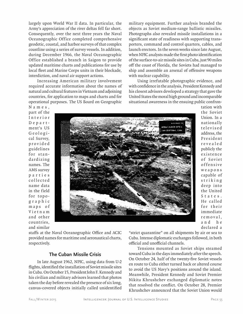
The Cuban Missile CrisisIn late August 1962, NPIC, using data from U-2
flights, identified the installation of Soviet missile sites in Cuba. On October 15, President John F. Kennedy and his civilian and military advisors learned that photos taken the day before revealed the presence of six long, canvas-covered objects initially called unidentified
military equipment. Further analysis branded the objects as Soviet medium-range ballistic missiles. Photographs also revealed missile installations in a significant state of readiness with supporting trans-porters, command and control quarters, cables, and launch erectors. In the seven weeks since late August, when NPIC analysts made the first photo identification of the surface-to-air missile sites in Cuba, just 90 miles off the coast of Florida, the Soviets had managed to ship and assemble an arsenal of offensive weapons with nuclear capability.
Using irrefutable photographic evidence, and with confidence in the analysis, President Kennedy and his closest advisors developed a strategy that gave the United States the moral high ground and incomparable situational awareness in the ensuing public confron-
tation with t he Soviet Union. In a nat ionally t e l e v i s e d address, the P r e s i d e n t r e v e a l e d publicly the e x i s t e n c e o f S o v i e t o f f e n s i v e w e a p o n s capable of s t r i k i n g deep i nt o the United S t a t e s . He c a l led f o r t h e i r immediate r e m o v a l , a n d h e declared a
“strict quarantine” on all shipments by air or sea to Cuba. Intense diplomatic exchanges followed, in both official and unofficial channels.
Tensions mounted as Soviet ships steamed toward Cuba in the days immediately after the speech. On October 24, half of the twenty-five Soviet vessels en route to Cuba either turned back or altered course to avoid the US Navy’s positions around the island. Meanwhile, President Kennedy and Soviet Premier Nikita Khrushchev exchanged diplomatic notes that resolved the conflict. On October 28, Premier Khrushchev announced that the Soviet Union would
Page 56 Intelligencer: Journal of U.S. Intelligence Studies Fall/Winter 2015
withdraw all missiles and related equipment from Cuba in exchange for a pledge from the United States not to invade the island. Only in the 1990s, with the opening of documents related to Soviet policy, did the world learn that the Soviet military in Cuba actually did have nuclear warheads at their disposal on the island and that the commanders in the area had the authority to use them.1 Not publicized at the time was President Kennedy’s agreement to remove similar missiles from Turkey, situated geographically as close to the Soviet Union as Cuba was to the United States.
Aerial surveillance photography had not only revealed the initial build-up of Soviet missiles in Cuba; it also revealed the missiles’ state of readiness and, during the quarantine, the nature of cargo carried by Soviet ships. Photographic interpreters once again clearly established the critical value of their craft.
September 11, 2001On September 11, radical Islamic terrorists
hijacked four commercial airliners and flew one of them into the Pentagon and two others into the twin towers of the World Trade Center in lower Manhattan. The fourth crashed in Pennsylvania when the passen-gers resisted and fought their hijackers. In all, some 3,000 innocent individuals lost their lives. President George W. Bush declared a global war on terrorism.
Two days later, NIMA welcomed retired Air Force Lieutenant General James R. Clapper Jr. as its second (and first civilian) director, succeeding geo-spatial pioneer Army Lieutenant General James C. King. Soon after his arrival, the new director began to promote products that emerged from a variety of new initiatives, like NIMA’s work on Chechnya in 2000. This ambitious synthesis of source and image emerged during General King’s tenure and became known simply as geospatial intelligence, or GEOINT. Among his newly created list of offices was the Office of Geospatial-Intelligence Management. Its mission was to provide the director, in his role as the geospatial intelligence functional manager for the Intelligence Community, with the plans and policies to manage geospatial intelligence resources and a new system to be known as the National System for Geospatial Intelligence (NSG). The first task of the new office was to develop and publish a series of formal com-munications that would comprise the doctrine of GEOINT. The first of these, Geospatial Intelligence
1. Dino Brugioni, Eyeball to Eyeball: The Inside Story of the Cuban Missile Crisis. (New York: Random House, 1991); Gary E. Weir, Rising Tide (New York: Basic Books), 2003.
Basic Doctrine, appeared in July 2004.2
The global war on terrorism dramatically changed the nature of NIMA’s priorities and prod-ucts. Recognizing that new threats could occur at any time or place, Director Clapper decided both to make regional analytic overviews more robust, and to embed NIMA analysts throughout the Defense Department’s military commands and the Intelligence Community. His concept of a unifying discipline and doctrine evolved into a new agency name — the National Geo-spatial-Intelligence Agency (NGA). The new name represented the maturation of a new discipline and the increased unification of NIMA’s parts.
The report by the House-Senate Intelligence Com-mittee investigating the September 11, 2001, attacks recommended creating a new Director of National Intelligence as the principal intelligence adviser to the president and the statutory intelligence advisor to the National Security Council. This cabinet-level official would coordinate all fifteen components of the Intelligence Community, a task that previously fell to the director of the CIA. On February 17, 2005, President George W. Bush named John Negroponte, former UN Ambassador and US Ambassador to Iraq, to the post. By April, Congress confirmed the Director of National Intelligence, and within months a new National Intelligence Strategy drove NGA operations.
NIMA becomes NGAThe National Imagery and Mapping Agency
(NIMA) officially became the National Geospatial-In-telligence Agency (NGA) with the November 24, 2003, signing of the fiscal 2004 Defense Authorization Bill.
The passage of the Homeland Security Act a year earlier clarified the agency’s role in supporting its national customers and helped strengthen NIMA’s relationship with other domestic agencies. After September 11, 2001, the agency quickly began to utilize tactics, techniques, procedures, and solutions it had long used overseas, only now applying them to domestic situations with congressional approval. Some of these new tasks included surveying the World Trade Center site as an aid to reconstruction efforts, and supporting the counterterrorism activities of the CIA. NGA also played a significant role in site exam-ination and response planning for major national and international events, working with domestic and overseas authorities to provide maps and geospatial intelligence for training and security at the Winter
2. James R. Clapper Jr., Geospatial Intelligence (GEOINT) Basic Doc-trine No.1, (Washington, DC: NGA, 2004).
Page 57Intelligencer: Journal of U.S. Intelligence StudiesFall/Winter 2015
Olympics in Salt Lake City (2002) and Turin (2006), and the summer games in Athens (2004). The same period saw more involvement in newly intensified efforts to protect the president of the United States, the vice president, and other high-ranking officials, and to provide better security for US military and other government facilities.
Operation Enduring FreedomThe swift military response to the 2001 terrorist
attacks on New York City and Washington, DC, chris-tened Operation Enduring Freedom (OEF), began on 7 October, and NIMA’s new product, GEOINT, followed American forces. OEF’s objectives, as articulated by President George W. Bush, included the destruction of terrorist training camps and infrastructure within Afghanistan, the capture of al Qaeda leaders, and the cessation of in-country terrorist activities. In addition to American participation, the coalition included more than sixty-eight nations, with twenty-seven nations having representatives at the headquarters of the US Central Command in Tampa, Florida.
As OEF began, the Taliban controlled more than eighty percent of Afghanistan and seemed poised to overwhelm their domestic opponents. By mid-March 2002, the coalition removed the Taliban from power in Afghanistan. Assisted by special maps, aeronautical navigation data, and geospatial intelligence products supplied by NIMA, US Transportation Command addressed all force positioning and most logistical needs in theater by air.
With a combination of overwhelming firepower, delivery systems, and ever more accurate targeting information from NIMA, the ratio of sorties to suc-cessful strikes improved dramatically, from an average of ten-aircraft-per-target during Desert Storm in 1991 to two-targets-per-aircraft during OEF. US airmen and aircraft, some operating from western Missouri and assisted by both NIMA navigational aids and on-site support, flew the longest combat missions in US his-tory, some taking more than fifteen hours, and broke another duration record for surveillance missions at twenty-six hours. The agency also supported extensive use of unmanned aerial vehicles, which permitted around-the-clock surveillance of critical sites, facili-ties, and troop concentrations.
Directed from Tampa by US Central Command, which provided real-time connectivity to forces oper-ating 7,000 miles away, the OEF effort drew support from 267 bases. The coalition operated from thirty locations in fifteen countries and regularly overflew
forty-six nations. In every case, NIMA’s ability to represent the battlefield literally and virtually at each location provided unprecedented insight into each mission.
Operation Iraqi FreedomOn March 19, 2003, the United States, United
Kingdom, and other coalition forces began conduct-ing military operations designed to depose Saddam Hussein and deprive the state of Iraq of any weapons of mass destruction it might possess. During Oper-ation Iraqi Freedom (OIF), imagery from reliable commercial satellites supplemented NGA’s own assets to supply the necessary imagery in support of diplomatic initiatives, humanitarian relief, and reconstruction efforts. Commercial imagery aided in defining deployment locations for Patriot missile and air defense batteries, assisted in mission planning for the seizure of Kirkuk in northern Iraq, and helped locate and characterize minefields along the border between Iraq and Iran. It demonstrated that coalition forces did not ignite the Baghdad oil fires, and pro-vided context for decisions to strike or pass on select Iraqi industrial targets.
The military and humanitarian efforts in Afghan-istan and Iraq occasioned the largest overseas deploy-ment of NGA and NIMA personnel in the history of the agency. To facilitate arrangements for their overseas tours and ensure efficiency, NIMA established the Office of Global Support, initially called the Office of Deployed and Externally Assigned Personnel, in August 2003.
Page 58 Intelligencer: Journal of U.S. Intelligence Studies Fall/Winter 2015
Beyond a NameWell before the tragedy of September 11, 2001,
intelligence that depended upon the Earth’s physical attributes, as well as the art and science of interpreting that information, changed quietly but fundamentally. Combining most of the nation’s capable imagery and geospatial intelligence assets within NIMA in 1996 went beyond simply addressing problems of efficiency and economy. Rather, NIMA suddenly provided a critical mass of skills and technologies under a single mission umbrella that soon enabled the Intelligence Community to realize a significant step in the evolu-tion of its craft and product. Creating NGA acknowl-edged, in name and in practice, the confluence of every possible sort of imagery with geospatial, human, signals, electronic, and open source intelligence. This confluence created the innovative, sophisticated, and powerful product NGA Director James Clapper for-mally christened GEOINT. The change of name from NIMA to NGA had little to do with semantics. The nature of intelligence had changed forever.
GEOINT demonstrated its unique ability to illuminate critical situations in ways that permitted both intelligent policy decisions and timely action. GEOINT confirmed ethnic cleansing atrocities in Kosovo through the latest in imaging and geospatial technology enhanced by an incomparable knowledge of culture and context. From the cities hosting the Olympics to the disaster of Hurricane Katrina in New Orleans, NGA provided timely GEOINT products that allowed American authorities at every level to improve the quality and the timing of their security and emer-gency response. Even the 2006 White House report, in reviewing the Katrina disaster response and offering recommendations for improvement, applauded NGA timeliness during the crisis. GEOINT offered a prelim-inary version of the same total picture for responders that the administration proceeded to recommend for the entire nation as a part of a standard plan to address major disasters.
While firmly rooted in a past that extends back to surveyors like the young George Washington and President Thomas Jefferson’s explorers Lewis and Clark, GEOINT has only recently emerged as a new synthesis of extraordinary technologies and valuable personal skills. The National Geospatial Intelligence Agency has the dual responsibility to learn daily from past GEOINT achievements and to practice, for the greater good, the powerful combination of technology and art it has created.
R e a d i n g s f o r I n s t r u c t o r s
Books and Monographs:Allyn, Bruce J., James G. Blight, and David A. Welch, eds.
Back to the Brink: Proceedings of the Moscow Conference on the Cuban Missile Crisis, January 27–28, 1989. Cambridge, MA: Center for Science and International Affairs, Harvard University; Lanham, MD: University Press of America, 1991.
Babington-Smith, Constance. Air Spy: The Story of Photo Intel-ligence in World War II. New York: Harper, 1957. Reprint, Falls Church, Virginia: American Society for Photogram-metry and Remote Sensing, 1985.
Brugioni, Dino. Eyeball to Eyeball: The Inside Story of the Cuban Missile Crisis. New York: Random House, 1991.
Buisseret, David, ed. From Sea Charts to Satellite Images: Inter-preting North American History Through Maps. Chicago: University of Chicago Press, 1990.
Crouch, Tom D. The Eagle Aloft: Two Centuries of the Balloon in America. Washington, DC: Smithsonian Institution Press, 1983.
Finnegan, Terrence J. Shooting the Front: Allied Aerial Recon-naissance and Photographic Interpretation on the Western Front—World War I. Washington, DC: National Defense Intelligence College, 2006.
Fischer, Irene K. Geodesy? What’s That?: My Personal Involve-ment in the Age-Old Quest for the Size and Shape of the Earth. New York: iUniverse, 2005.
Goss, John. The Mapmaker’s Art: An Illustrated History of Car-tography. London: Studio Editions, 1993.
Haydon, Frederick Stansbury. Military Ballooning During the Early Civil War. Baltimore, M.D.: John Hopkins University Press, 2000.
Kahn, David. The Codebreakers: The Story of Secret Writing. New York: MacMillan Publishing Company, Inc., 1967.
Keegan, John. Intelligence in War: Knowledge of the Enemy from Napoleon to Al-Qaeda. New York: Random House, 2003.
Maury, Matthew Fontaine. Physical Geography of the Sea and Its Meteorology, ed. John Leighly. Cambridge: Harvard University Press, 1963.
McAuliffe, Mary S., ed. CIA Documents on the Cuban Missile Crisis, 1962. Washington, DC: History Staff, Central Intelligence Agency, 1992.
McDonald, Robert A. Corona—Between the Earth and the Sun: The First NRO Reconnaissance Eye in Space. Bethesda, MD: American Society for Photogrammetry and Remote Sensing, 1997.
Pedlow, Gregory W. and Donald E. Welzenbach. The CIA and the U-2 Program, 1954–1974. Washington, DC: Central Intelligence Agency, 1998. [https://www.cia.gov/csi/books/U2/]
Pinsel, Marc I. 150 Years of Service on the Seas: A Pictorial History of the U.S. Naval Oceanographic Office from 1830 to 1980. Vol. 1, 1830–1946. Washington, DC: GPO, 1982.
Richelson, Jeffrey T. America’s Secret Eyes in Space: The U.S. Key-hole Spy Satellite Program. New York: Harper Collins, 1990.
Page 59Intelligencer: Journal of U.S. Intelligence StudiesFall/Winter 2015
Robarge, David. Intelligence in the War for Independence. Wash-ington, DC: Center for the Study of Intelligence, 1997.
Ruffner, Kevin C., ed. CORONA: America’s First Satellite Pro-gram. Washington, DC: Central Intelligence Agency, 1995.
Stanton, William. The Great United States Exploring Expedition of 1838–1842. Berkeley: University of California Press, 1975.
Weber, Gustavus A. The Hydrographic Office: Its History, Activ-ities, and Organization. Baltimore: Johns Hopkins Press, 1926. Reprint, Washington, DC: AMS Press, 1974.
Wilford, John Noble. The Mapmakers: The Story of the Great Pioneers in Cartography—from Antiquity to the Space Age, 2d ed. New York: Knopf, 2000.
Periodicals:Brugioni, Dino. “Aerial Photography: Reading the Past,
Revealing the Future.” Smithsonian 14, no. 12 (December 1984): 150–161.
Brugioni, Dino, and Robert Poirier. “The Holocaust Revis-ited: A Retrospective Analysis of the Auschwitz-Birkenau Extermination Complex.” Studies in Intelligence 22, no. 4 (Winter 1978): 11–29.
Doll, John G. “Cloth Maps of World War II.” Western Associ-ation of Map Libraries 20, no. 1 (November 1988): 24–35.
Hall, R. Cargill. “From Concept to National Policy: Strategic Reconnaissance in the Cold War.” Prologue 28, no. 2 (Summer 1996): 113.
Hall, R. Cargill. “Origins and Development of the Vanguard and Explorer Satellite Programs.” Air Power Historian 9 (October 1964): 102–108.
Hall, R. Cargill, and Donald E. Hillman. “Overflight: Strategic Reconnaissance of the USSR.” Air Power Historian 43, no. 1 (Spring 1996): 28–39.
Hudson, Alice, and Mary McMichael Ritzlin. “Introduction to the Preliminary Checklist of Pre-Twentieth-Century Women in Cartography.” Cartographica 37, no. 3 (Fall 2000).
Luvaas, Jay. “The Role of Intelligence in the Chancellorsville Campaign, April–May 1963.” Intelligence and National Security 5, no. 2 (April 1990): 99-115.
Richelson, Jeffrey T. “The Keyhole Satellite Program.” Journal of Strategic Studies 7, no. 2 (1984): 121–153.
Sayle, Edward F. “George Washington, Manager of Intelli-gence.” Studies in Intelligence 27, no. 4 (Winter 1983): 1–10.
Schultz, Mark E. “The Power of Geospatial Intelligence.” Defense Intelligence Journal 14, no. 1 (2005):79–87.
Tyner, Judith. “The Hidden Cartographers: Women in Map-making,” Mercator’s World 2, no. 6 (November – Decem-ber 1997): 46–51.
Dr. Gary E. Weir is Chief Historian at the National Geospatial-Intelligence Agency, a guest investigator with the Woods Hole Oceanographic Institution, and teaches for the University of Maryland. His works include “Fish, Family, and Profit: Piracy and the Horn of Africa,” part of Piracy and Maritime Crime,
the Naval War College’s Newport Paper Number 35 (2010). Sponsored by a lessons-learned grant from the Director of National Intelligence, Dr. Weir also examined the development of hyperspectral science as an intelligence tool (2011) and then for NGA explored the evolution of Activity-Based Intelligence (2013). His present work focuses on the history of geo-positioning at NGA.