the effects of sedimentation from unpaved roads on coral ... · areas where local people work...
TRANSCRIPT
The effects of sedimentation from unpaved roads on coral reefs: an analysis of
St. John, USVI and Koh Tao, Thailand
D.V. University of Richmond, Class of 2012 Environmental Studies Senior Seminar
Adviser: Dr. David S. Salisbury April 2012
Abstract: Land-based sediments pose one of the greatest threats to the destruction of coral reefs. On St. John, USVI, sedimentation from unpaved roads has been identified as the dominant source and greatest threat to its coral reefs. Local and national organizations are now using the research to develop best management practices for minimizing sedimentation rates on St. John. However, many other islands surrounded by coral reefs are unaware of the threats from unpaved roads, and use solely a marine-based approach to reef conservation. This paper analyzes and compares the geography, coral reef characteristics, and road networks of St. John and Koh Tao, Thailand to see if sedimentation from unpaved roads can be considered a threat to Koh Tao’s reef. The results find road-based sedimentation a threat and argue for Koh Tao to take a land and marine-based approach to conserving its reefs, attacking the threat of sedimentation at its source. Keywords: coral reefs, sedimentation, St.John, Thailand, roads, conservation

The effects of sedimentation from unpaved roads on coral reefs: an analysis of St.
John, USVI and Koh Tao, Thailand
Introduction
As the tourism industry drastically expanded on St. John, US Virgin Islands,
developers constructed hundreds of unpaved dirt roads to facilitate the fast-paced
population growth on the island. During rain storms, the unpaved roads created runoff
from the mountainous terrain of St. John, and sedimentation smothered the coral reefs
surrounding the island. Due to the geography of the island, coral reef characteristics, and
dirt road network, the biggest threats to coral reefs around the island was considered
sedimentation from unpaved roads. Sedimentation drastically threatens the ability for
reefs to survive. This study uses existing research on the sedimentation from unpaved
roads on St. John to apply to the interaction between other island infrastructure systems
and coral reefs around the world. For decades, individuals and organizations conducted
studies in St. John on the amounts of sedimentation reaching coral reefs from unpaved
road segments, and discovered what road variables contribute to highest sedimentation
rates. The local St. John community and larger conservation organizations now use the
research findings to develop different strategies and techniques to minimize
sedimentation rates from unpaved roads. Interestingly, there remains minimal research on
sedimentation from unpaved roads and runoff into the ocean besides the existing
exploration on St. John. The process of conducting similar studies in new locations
requires large amounts of time, money, and effort. However, a faster and less costly
approach would be to use the research and findings on St. John and apply this knowledge
to help other coral reef communities minimize sedimentation. However, these alternate
reef communities must show consistent similarities to St. John in their geography, road
structures, and coral reef systems. Without constant parallels, sedimentation from
unpaved roads in other regions may not be a major threat to their coral reefs, and the
mitigation techniques used in St. John may prove unsuccessful. In this paper, I want to
evaluate the coral reefs, geography, and road system on the island of Koh Tao, Thailand,
and determine if the findings and mitigation strategies used in St. John can be applied to
the island. If many similarities exist between the development, terrain, coral reef
dynamics, soils, and weather patterns of St. John and Koh Tao, the same strategies could
be used on Koh Tao to help minimize the negative effects of unpaved roads. The research
can help Koh Tao and other similar islands find the best management practices to reduce
sedimentation from unpaved roads and save their coral reef ecosystems.
Literature Review
Many people living near coral reefs depend on reef resources for survival. Local
coastal communities use the reef for the backbone of their local economy (VI CB&D,
2010). Reefs remain vulnerable environmental resources, providing necessary food,
security, and safety to millions of people across the globe. Coral reefs provide ecosystem
goods and services including tourism, fisheries, coastal protection, biodiversity, and
carbon sequestration. According to one estimate, the yearly net benefit of the world’s
coral reefs is $29.8 billion (Cesar et al., 2003). However, coral reefs may be the most
globally endangered of all ecosystems (Mumby and Steneck, 2008). Threats to coral
reefs include ocean acidification, ocean warming, increased levels of carbon dioxide in
the air, water pollution, sedimentation, coastal development, destructive fishing practices,
coral mining, careless tourism, and ozone depletion (Coral Reef Alliance, 2010). One
study discovered over half of the world’s coral reefs disappeared since 1980 (Mongabay,
2008).
Marine Protected Areas (MPA) represent one of the major ways to combat coral
reef decline globally. Currently, over 6,800 MPA’s exist across the world’s oceans, many
of which protect coral reef ecosystems (IUCN, 2010). The regulations for each MPA
greatly differ, but every MPA claims to help conserve the natural aquatic environment in
some way. Restrictions for each MPA may include fishing practices, development, catch
limits, removing marine life, mooring in certain locations, and many others. Many
Marine Protected Areas continually face opposition due to their lack of enforcement and
inability to preserve the reef. Many national authorities regulate Marine Protected Areas,
but studies show keys to coral reef protection focus on local management and knowledge
(Mumby and Steneck, 2008). Other problems with MPA’s include solely focusing on the
protection of the underwater reef without connecting the threats from land-based sources
of pollution (Keller et al., 2009.) Understanding and attacking each threat remains an

essential part to protecting the world’s coral reef systems. Successful MPA’s exist in
areas where local people work together to control and manage all water and land-based
threats to coral reefs. Without a collaborative approach, incorporating and understanding
both land and ocean-based threats, the future for coral reefs remains daunting.
A recent study found land-based sediment onto coral reefs the biggest threat to
their depletion in future years (Burke et al., 2011). Some estimates indicate erosion and
sedimentation represent a high threat to over 22% of the earth’s coral reef ecosystems. At
local scales, sedimentation and runoff can be the biggest pressure on inshore reefs and
cause the most harm to their ecological balance (ISRS, 2004). Land based sources of
sediment can negatively affect coral reefs in several ways. Sedimentation effects can
include “1) smothering of coral colonies by excess sedimentation; 2) reducing light
availability due to high turbidity of the water column potentially inducing bleaching
stress responses 3) physical abrasion that cause tissue damage or loss; 4) changes in pH
and salinity that may trigger bleaching stress responses; 5) eutrophication from increased
nutrient loads and proliferation of undesirable species such as algae, weedy corals, etc.
and 6) loss of biodiversity and ecosystem services which can affect wider interactions
including fish populations” (VI CB&D, 2010). These effects kill off coral sections,
reduce biodiversity in the reef, and require living organisms to expend more energy to
shed the sediment, thus making the total ecosystem more vulnerable to disease and less
resilient to natural resources (Rogers, 1990).
A study on St. John, USVI determined the unpaved road network as the dominant
source of sedimentation onto its coral reefs. During rain storms, the unpaved roads act as
pathways for dirt, clays, and pollutants to travel down the mountainous terrain of St. John
and onto the reefs surrounding the island (Anderson and MacDonald, 1998). Although
other islands contain similar geographic features and road networks as St. John, minimal
research exists on sedimentation rates in other areas. Studies on sedimentation usually
take at least one year because they evaluate each seasons unique precipitation rates
(Ramos-Scharron & MacDonald, 2005). The studies also require large amounts of
funding, expertise, and effort from many individuals. This research paper provides a
collaboration of existing knowledge about sedimentation from unpaved roads and its
effects on coral reefs. With serious declines in coral reefs from sedimentation,
communities must find fast and effective ways to manage their essential reef ecosystems
and reduce sedimentation rates. Rather than conducting new research, individual islands,
including Koh Tao, can use this paper and the studies of St. John to determine the best
methods to help prevent sedimentation from unpaved roads. If other coastal regions
contain similarities to St. John in geographic characteristics, reef structures, and unpaved
road networks, they can use the information in efforts to minimize sedimentation rates on
current and future development of unpaved roads.
The state of existing knowledge on coral reef sedimentation rates from unpaved
roads on St. John Island remains abundant. However, very few other coastal regions have
directly studied unpaved roads and their relation to sedimentation on coral reefs. In the
Caribbean, many studies focus on mass wasting (Larsen and Parks, 1997; Jibson, 1989),
while others relate towards surface erosion studies in general (Gumbs and Lindsay, 1982;
Tirado and Lugo-Lopez, 1984) but lack the connection of unpaved roads and sediment
being delivered to the ocean. Other studies across the world focused on sediment data for
unpaved roads, but did not include rates entering coral reef ecosystems. Some examples
include Australia (Bren and Leitch, 1985), New Zealand (Fahey and Coker, 1992) and
Thailand (Ziegler et al., 2001).
A 1998 study on St. John linked the connection of unpaved road sedimentation
and its delivery to different bays containing coral reef ecosystems (Anderson and
MacDonald, 1998). Using an empirical road erosion model (ROADMOD), the authors
found the unpaved road network to be the dominant source of sediment, causing
sedimentation yields to the reefs four times higher compared to areas without roads
(Anderson and MacDonald, 1998). The ROADMOD system contained limited data and
lacked important factors controlling road erosion rates, like precipitation or frequency of
grading. While the study presented initial estimates of sediment delivery rates from
unpaved roads, the research contained no field data measurements to determine the
primary factors controlling runoff and sediment delivery during individual storms. The
deficiencies in the research made assessing the larger-scale impacts of current and
proposed roadways in St. John impossible.
A later study aimed to collect field data and measure the exact amounts of
runoff and sediment production from vegetated plots and unpaved roads on St. John
(MacDonald et al., 2001). The study used three different areas across the island to test
sedimentation rates in relation to precipitation and slope of terrain. The findings showed
road surface runoff could best be predicted by storm precipitation and road size, as
sedimentation rates were significantly correlated with runoff, intensity, and precipitation.
Unlike unpaved roads, the undisturbed vegetated hill slopes only generated runoff during
the largest storms, with minimal sedimentation. However, unpaved roads in the study
generated runoff when rainfall exceeded anything more than 6 mm. The research also
documented several basic mitigation strategies, including paving the roads and creating
inslopes, but still needed additional information to determine key factors of sedimentation
from unpaved roads (mitigation techniques described in detail in analysis). Ramos-
Scharron and MacDonald (2005) found minimizing the frequency of grading and
improving road drainage as the best means to reduce erosion. Their study aimed to not
only measure sediment production at different unpaved sites and evaluate precipitation,
but also looked into evaluating sedimentation effects determined by the traffic and
grading of each road. By evaluating 21 road segments on St. John, the study found
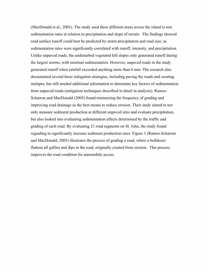
regrading to significantly increase sediment production rates. Figure 1 (Ramos-Scharron
and MacDonald, 2005) illustrates the process of grading a road, where a bulldozer
flattens all gullies and dips in the road, originally created from erosion. This process
improves the road condition for automobile access.
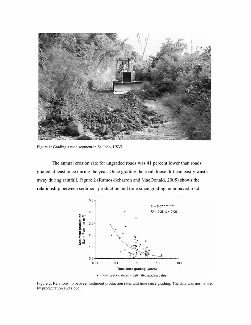
Figure 1: Grading a road segment in St. John, USVI.
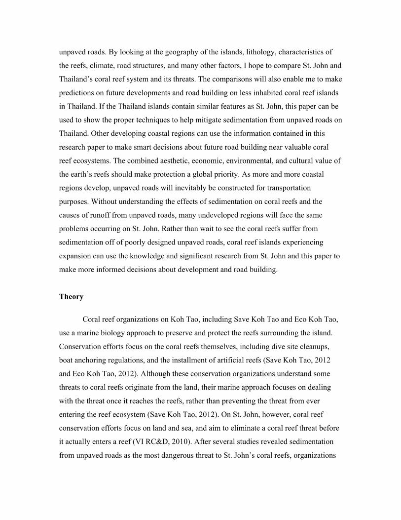
The annual erosion rate for ungraded roads was 41 percent lower than roads
graded at least once during the year. Once grading the road, loose dirt can easily waste
away during rainfall. Figure 2 (Ramos-Scharron and MacDonald, 2005) shows the
relationship between sediment production and time since grading an unpaved road.
Figure 2: Relationship between sediment production rates and time since grading. The data was normalized by precipitation and slope.

Several studies also looked into the differences of slopes for unpaved roads and
its effects on sedimentation rates. Measured sediment production rates for unpaved roads
“ranged from 5.7 Mg ha/yr for a road with a slope of 2% to 580 Mg ha/yr for a road with
a slope of 21%” (Ramos-Scharron and MacDonald, 2007). An earlier study found road
segment slope as an important control on sediment production, and argued sedimentation
from unpaved roads drastically increases with the slope of the terrain (Ramos-Scharron
and MacDonald, 2005).
The research performed on St. John provides vital information on sedimentation
from unpaved roads and its effects on coral reefs, and the research can be used by
organizations to develop ways to reduce sedimentation. Sedimentation from unpaved
roads on St. John results in rates four orders of magnitude higher than undisturbed
hillslopes (Ramos-Scharron and Macdonald, 2007). Aside from St. John, only a few
studies look at the delivery of sediment from unpaved roads to the ocean. One study in
Puerto Rico aimed to measure the sediment rates from abandoned unpaved roads and
evaluate the effects from precipitation, slope, plot size, and vegetation cover. Similar to
research on St. John, the study found larger runoff rates for roads with steeper slopes and
larger areas (Ramos-Scharron, 2010). The study also revealed vegetation as an important
role in sedimentation rates. During the two-year study period, sedimentation rates for
each of the nine abandoned roads became smaller, and these differences can be attributed
partially to re-grown vegetation on the abandoned roads. Communities in St. John and
Puerto Rico currently use this vital information to develop strategies fighting against
sedimentation from unpaved roads. These different techniques will be discussed later in
the paper.
While existing studies show unpaved roads as the leading cause of sedimentation
onto coral reefs in St. John, no similar studies exist for other coral reef regions in the
world. Several studies look at sedimentation rates on coral reefs in Thailand, but none
focus on the major impacts from unpaved roads. Examples of such studies in Thailand
include the effect of sedimentation from coastal mining in Phuket (Chansang et al., 1981)
and the effects of sedimentation and climatic patterns on coral reef biodiversity in Phuket
(Brown et al., 2002). Using the studies conducted on St. John, I will see if islands with
coral reefs in Thailand appear vulnerable to large amounts of sedimentation from
unpaved roads. By looking at the geography of the islands, lithology, characteristics of
the reefs, climate, road structures, and many other factors, I hope to compare St. John and
Thailand’s coral reef system and its threats. The comparisons will also enable me to make
predictions on future developments and road building on less inhabited coral reef islands
in Thailand. If the Thailand islands contain similar features as St. John, this paper can be
used to show the proper techniques to help mitigate sedimentation from unpaved roads on
Thailand. Other developing coastal regions can use the information contained in this
research paper to make smart decisions about future road building near valuable coral
reef ecosystems. The combined aesthetic, economic, environmental, and cultural value of
the earth’s reefs should make protection a global priority. As more and more coastal
regions develop, unpaved roads will inevitably be constructed for transportation
purposes. Without understanding the effects of sedimentation on coral reefs and the
causes of runoff from unpaved roads, many undeveloped regions will face the same
problems occurring on St. John. Rather than wait to see the coral reefs suffer from
sedimentation off of poorly designed unpaved roads, coral reef islands experiencing
expansion can use the knowledge and significant research from St. John and this paper to
make more informed decisions about development and road building.
Theory
Coral reef organizations on Koh Tao, including Save Koh Tao and Eco Koh Tao,
use a marine biology approach to preserve and protect the reefs surrounding the island.
Conservation efforts focus on the coral reefs themselves, including dive site cleanups,
boat anchoring regulations, and the installment of artificial reefs (Save Koh Tao, 2012
and Eco Koh Tao, 2012). Although these conservation organizations understand some
threats to coral reefs originate from the land, their marine approach focuses on dealing
with the threat once it reaches the reefs, rather than preventing the threat from ever
entering the reef ecosystem (Save Koh Tao, 2012). On St. John, however, coral reef
conservation efforts focus on land and sea, and aim to eliminate a coral reef threat before
it actually enters a reef (VI RC&D, 2010). After several studies revealed sedimentation
from unpaved roads as the most dangerous threat to St. John’s coral reefs, organizations
including Coral Reef Alliance and the US Coral Reef Task Force quickly developed and
implemented erosion control strategies on the island (Division of Environmental
Protection, 2010). In this paper, I use a geographic and historical framework to compare
the two islands, their road system, and its coral reefs. If the islands possess many
similarities, I will argue Koh Tao can use the same erosion control plans as St. John to
reduce the threat of sedimentation on its coral reefs. I will be taking Thailand’s marine-
based conservation efforts and incorporating land-based conservation strategies related to
unpaved roads to help better protect the valuable reefs surrounding Koh Tao.
Different countries, cities, and communities surrounded by coral reefs create their
own regulations and guidelines to protect the future of their valuable coral reef
ecosystem. Each coral reef remains unique, and a serious threat to one reef could be
minimally damaging towards another. For example, several off-shore reefs face a serious
threat from overfishing, yet seem unaffected from careless tourism practices. However,
reefs located near heavily populated tourist areas can be constantly destroyed from
careless boating, diving, and snorkeling (Coral Reef Alliance, 2010). A 2011 study
(Burke et al., 2011) found local threats to coral reefs the most severe in Southeast Asia
and least severe in Australia, and further emphasized the different threats for each coral
reef location.
Although many communities seem aware of the decline in coral reefs, their efforts
to protect their reefs prove unsuccessful. Reasons for failure can range anywhere from
poor management and regulation to incorrect conservation planning. Only fifteen percent
of the world’s Marine Protected Areas (MPA) qualify as being “effective” (Burke et al.,
2011). The MPA approach to protect coral reefs continues to be unsuccessful and full of
flaws, and other techniques must be used in order to provide a future for coral reef
ecosystems (Burke et al., 2011).
On the island of Koh Tao, Thailand, several local, national, and global
organizations continue to work together to help preserve the coral reefs around the island.
Two of the largest conservation programs include Save Koh Tao and Eco Koh Tao.
Established in 2000, Save Koh Tao’s goal involves strengthening the community,
improving the usage of the coral reefs, being a leader of sustainable and eco-friendly
development, and helping to provide a sustainable living island for future generations

(Save Koh Tao, 2012). Save Koh Tao works with tourism agencies, dive companies,
business owners, and local people to find the best ways at protecting the rich coral reef
ecosystems surrounding the island. Eco Koh Tao’s “aim is for the preservation and
conservation of marine environments through education, awareness, and action” (Eco
Koh Tao, 2012). Eco Koh Tao works with several international partners, including
United Nations Environment Program and Coral Reef Alliance, to protect the reefs.
Through education, action, and research, Eco Koh Tao hopes to provide a positive
influence on the future for Koh Tao and its coral reefs.
To date, NGO’s in Koh Tao have used a marine conservation approach to
minimize the threats on coral reefs. However, this may prove insufficient because many
land-based threats can be devastating once entering the reef ecosystems. Both Save Koh
Tao and Eco Koh Tao have several ongoing marine conservation projects, yet lack
projects based on the land. Current projects from Eco Koh Tao include a reef check and
ecological monitoring program, Buoyancy World, artificial reefs, BioRock, beach and
dive site clean ups, mooring buoy projects, coral nurseries, a giant clam nursery, and
whale shark and turtle sighting databases (Eco Koh Tao, 2012). These projects focus
around a marine biology framework consisting of direct reef rebuilding and cleanup, thus
minimizing reef threats. For example, Buoyancy World, Save Koh Tao’s major project
for 2009, created an artificial underwater playground for novice divers to practice
buoyancy before heading off to actual reefs. Rather than divers touching and destroying
actual sections of a coral reef, Buoyancy World provides an alternate area for divers to
become comfortable with being underwater before accessing reef ecosystems. Save Koh
Tao also set up artificial reefs around the island from household appliances and furniture,
and the reefs now welcome many species of fish. The artificial reefs also help spread out
the number of divers at each site on a daily basis and reduce the risk of over-diving on
authentic coral reef sites. The Mooring Buoy Project created several proper boat mooring
systems around the island, and significantly reduced reef damage from anchoring and
improper mooring installation (Eco Koh Tao, 2012).
Save Koh Tao uses similar marine biology based projects to protect the coral reef
systems around the island. BioRock remains one of their biggest accomplishments over
the previous years. BioRock, an artificial reef structure placed near living reef systems,

uses low voltage electrical current to improve the growing conditions for corals and reef
organisms (Save Koh Tao, 2012). BioRock establishments around Koh Tao increase
coral health, biodiversity, and fish abundance dramatically (Marine Conservation Koh
Tao, 2012). Save Koh Tao also works with local dive schools to organize underwater and
beach clean ups from rubbish on the island. Between 2008 and 2010, Save Koh Tao
organized 29 clean-ups which helped protect the reefs from structural damage and
improved the appearance of beaches and dive sites. Save Koh Tao’s Ecological
Monitoring Program collects detailed information on the biodiversity and abundance of
fish and coral species on the reefs. Combining this information with water quality tests,
Save Koh Tao can follow the trends in the health of reefs around the island (Marine
Conservation Koh Tao, 2012).
Although conservation organizations on Koh Tao understand and acknowledge
coral reef threats from wastewater and runoff, their approaches to minimizing reef
destruction around the island rely on working and studying the reef itself, rather than
solving proximate causes and drivers of destruction. In this paper, I want to use an
alternative framework in solving problems related with coral reef decline on Koh Tao.
Both organizations make note on their respective websites about the negative impacts
development and deforestation have on the coral reefs on Koh Tao, and also note the
negative impacts from sedimentation. However, their efforts to solve the problem involve
working directly in the water and on the reef, rather than on the land itself. By waiting for
the problem to reach the reefs, the ability to solve the problem remains impossible.
Although efforts like BioRock, Buoyancy World, ecological monitoring programs, and
artificial reefs help preserve the existence of reefs around Koh Tao, they do not directly
solve the threats from coral reef decline or eliminate any of the sedimentation. A reef
conservation framework for Koh Tao must include attacking land-based threats at its root
before reaching the reefs.
As mentioned earlier in this paper, a study found sedimentation on St. John the
major threat to its coral reef ecosystems and the main reason for the reefs deterioration.
The study further explained unpaved road networks to be the dominant source of
sedimentation (Anderson and MacDonald, 1998). Reef conservation efforts now use a
marine and land based approach to mitigate reef threats. Conservation strategies include
marine-based efforts like those found in Koh Tao, but also emphasize an importance on
developing and implementing erosion control plans. Several organizations have already
used these different strategies to greatly reduce the sedimentation threat to coral reefs on
St. John (UVI, 2010).
One study found sedimentation and wastewater pollution associated with rapid
coastal development to be a major threat to coral reefs in the gulf of Thailand, including
the island of Koh Tao (Yeemin et al., 2006). However, no studies exist in Thailand
explaining the dominant sources of sedimentation onto the coral reefs. Although
conservation organizations understand sedimentation kills the reefs and leads to major
declines in biodiversity and reef health, they have no ability to stop the problem before it
reaches the reefs simply because there remains no available information about
sedimentation sources on Koh Tao. Instead, the organizations work in the water with a
marine biology approach and help preserve the reefs once sedimentation has already
settled onto the reefs.
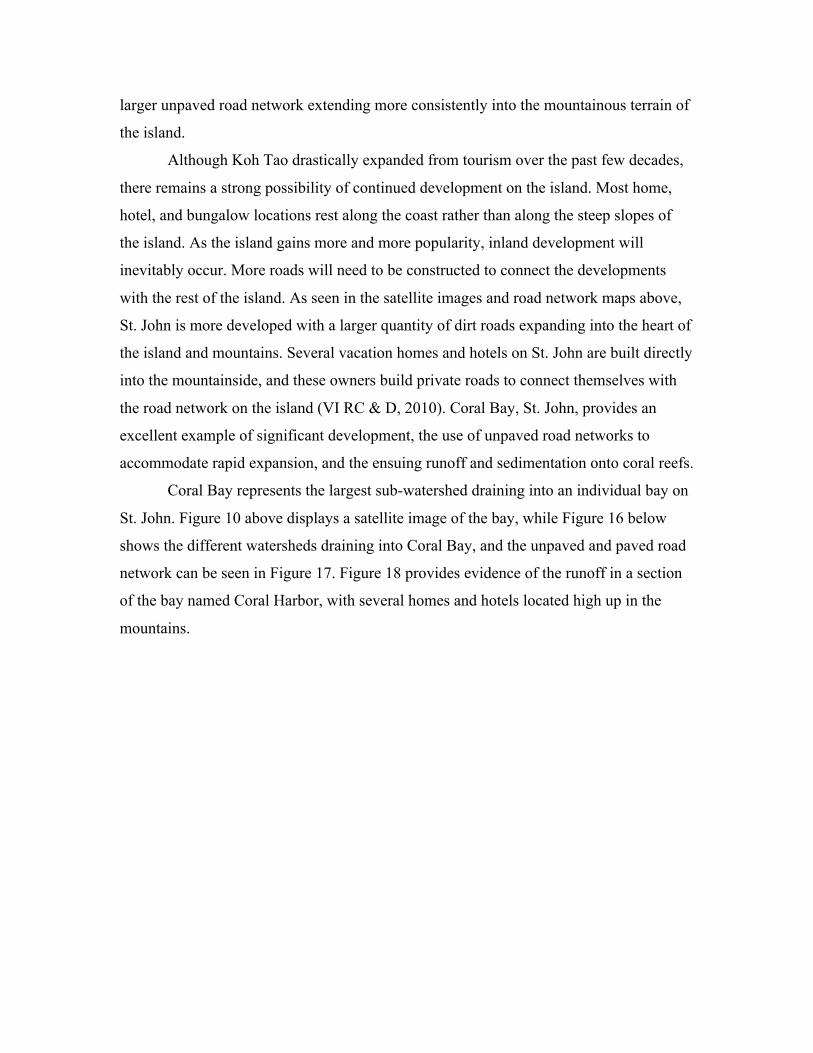
From personal experiences on Koh Tao and St. John, I have seen several
similarities in the landscape of the islands and the formation of the coral reefs around the
island. I spent over a week on Koh Tao, earning my PADI scuba-diving license and
diving at several dive sights around the island. I used a Buoyancy World site on my first
dive, saw coral reef destruction at other sites, and witnessed the impacts on reefs from
large diving group lessons. I rented a motorbike for several days and traveled around the
island’s dirt roads and up into the mountains, and could see the impacts from rain on the
fallout of road sections. Figure 15 provides an example of a road section after heavy
precipitation. I have also spent time scuba diving on the reefs around St. John and hiking
on sections of the island. Although I saw several similarities in the roads and reefs of Koh
Tao and St. John, these were only personal observations with no rigorous fieldwork or
substantive geographic information or analysis.
In this study, I use geographic information on the landscape of both islands to see
if similarities truly exist. This includes information on rock type, precipitation patterns,
climate, and road design. I also want to look into details of reef sites, including size,
depth, and distance to shoreline and unpaved roads. By using a geographic approach to
understand similarities and differences in Koh Tao and St. John, I will be able to predict

if runoff from unpaved roads can be considered a serious threat to the coral reefs in Koh
Tao. Methods will include comparing quantitative and qualitative data on the geography
of the islands, analyzing pictures and images from Google earth, and comparing coral
reef data for Koh Tao and St. John. The paper will also include a historical framework for
both islands, looking at development and future growth.
This paper does not solve the issue of coral reef decline on Koh Tao or St. John.
Unpaved roads can only be considered one of several sources of sedimentation on coral
reefs, and sedimentation can be considered only one of the several threats to coral reef
ecosystems. However, the ability to preserve the coral reef systems on Koh Tao for future
generations may not be possible without finding solutions to prevent unpaved road
runoff. The numerous studies on St. John provide experts vital information on
sedimentation sources, and several implementation plans are now used in St. John to
minimize runoff (UVI, 2010). If enough similarities exist between the geography, road
networks, and reefs of both islands, conservation organizations on Koh Tao may find the
same strategies useful to help prevent runoff. Additionally, if the analysis proves the
islands to be very similar, sedimentation from unpaved roads can also be considered a
high threat to Koh Tao’s reefs.
The preservation of coral reef ecosystems requires a collaboration of efforts from
multiple sources. Save Koh Tao and Eco Koh Tao already use several important marine
biology approaches to protect the reefs around the island. However, their efforts must
also focus on preventing land-based pollution sources from reaching the reefs. This paper
uses an environmental impact assessment approach, analyzing both terrestrial and marine
components and road networks over space and time to compare the islands and determine
if Koh Tao can use the same runoff mitigation strategies as St. John for unpaved roads.
Other management practices remain necessary to provide the best conservation to coral
reefs, but if results show constant similarities, sedimentation from unpaved roads may be
the biggest threat to coral reefs in Koh Tao. The paper will then provide the best
strategies to alter Koh Tao’s marine- based approach to preserving its coral reefs and
include emphasis on mitigating runoff from unpaved roads before it reaches and harms
the valuable reefs.
Methodology Increased sedimentation from unpaved roads and the associated decline of coral
reefs remains a critical environmental issue for St. John, USVI and other tropical coral
reef areas. The studies on St. John provide excellent information on the causes of
increased sedimentation, and give detail on unpaved roads and its effects (Macdonald et
al., 2001, Ramos-Scharron, 2010, Ramos-Scharron and MacDonald, 2005). As stated
earlier, the studies reveal unpaved roads to be the biggest reason for large sedimentation
inputs onto the coral reefs surrounding the island (Anderson and Macdonald, 1998).
Further, the studies identified what forms of roads (slope, grade, location) produce the
most sediment and runoff into the reef ecosystems. Today, NGO’s, local organizations
and communities, and individuals use this information to implement sediment and
erosion control techniques on the island. The information proves to be useful for future
development and road planning on the island as well.
To transfer this knowledge and valuable information to the island of Koh Tao,
Thailand, the geographic characteristics, road networks, and coral reef features of both
islands must be similar. If the islands do not take after one another, the sedimentation
control techniques on St. John may not be useful for the island of Koh Tao. Several
methodologies and sources will be used to identify similarities and differences between
the islands and their coral reef ecosystems.
The first step of analysis in this paper will compare the geography and landforms
for both islands with qualitative and quantitative information. Using maps, statistical
information, and images of both islands, I will compare information on island size,
location, slope, soil, precipitation, and climate. A comparison between the coral reefs for
both islands will include information on bays, coral reef depths, dive site locations, water
fluidity, and distance from land. The effects of sedimentation on coral reefs depend on
individual reef characteristics including depth, distance to shore, and location (VI RC &
D, 2010). Road networks and development will also be compared between the islands
using historical data, satellite imagery, personal descriptions from locals and tourism
websites, and images of road segments. The geographic characteristics of the islands and
their road systems play a vital role in the amount of sedimentation reaching a reef. A case
study in Coral Bay, St. John will then be used to evaluate the above information and
determine whether or not Koh Tao can use similar techniques to minimize sedimentation
onto its reefs.
Due to the significant and chronic impacts sediments have on coral reefs, the
USVI Department of Planning and Natural Resources Division of Coastal Zone
Management developed a watershed management plan for the bay and its surrounding
area. The report presents a framework for managing the Coral Bay watershed in St. John,
and puts emphasis on developing strategies to reduce sedimentation from unpaved roads.
The report acknowledges major reductions in sedimentation can be achieved through
local applications of watershed-based management and use of Best Management
Practices (BMP’s) (VI RC &D, 2010). If the methodologies used in this paper show
similarities between the two islands, then the control techniques and BMP’s for unpaved
road sedimentation can be applied towards the island of Koh Tao. The case study will
also help determine what areas and bays on Koh Tao face the highest risk of
sedimentation onto its coral reefs.
The paper contains no numerical data on actual sedimentation rates for Koh Tao.
Although the lack of data may be seen as a drawback in the analysis, such studies require
substantial amounts of time, effort, and money. Rather than investing energy into
individual studies on Koh Tao, money and efforts could be used to construct sediment
and erosion control sites on the island. The paper also lacks detailed scientific
information on individual road slope and size for Koh Tao. An analysis using GIS would
provide statistical numbers for Koh Tao and should be considered for future studies on
the island. However, the methodologies used in this paper should provide enough
information to determine whether Koh Tao faces great risks from sedimentation on
current and future developments, and discuss the best methods to prevent high
sedimentation rates from unpaved roads on coral reefs. This paper provides a simple and
cost-effective approach to guide Koh Tao in developing strategies to reduce land-based
threats to coral reefs. Rather than using only marine approaches to protect their valuable
reef ecosystem, the paper offers information to reduce one of the many land-based reef
threats of Koh Tao before reaching the ocean.
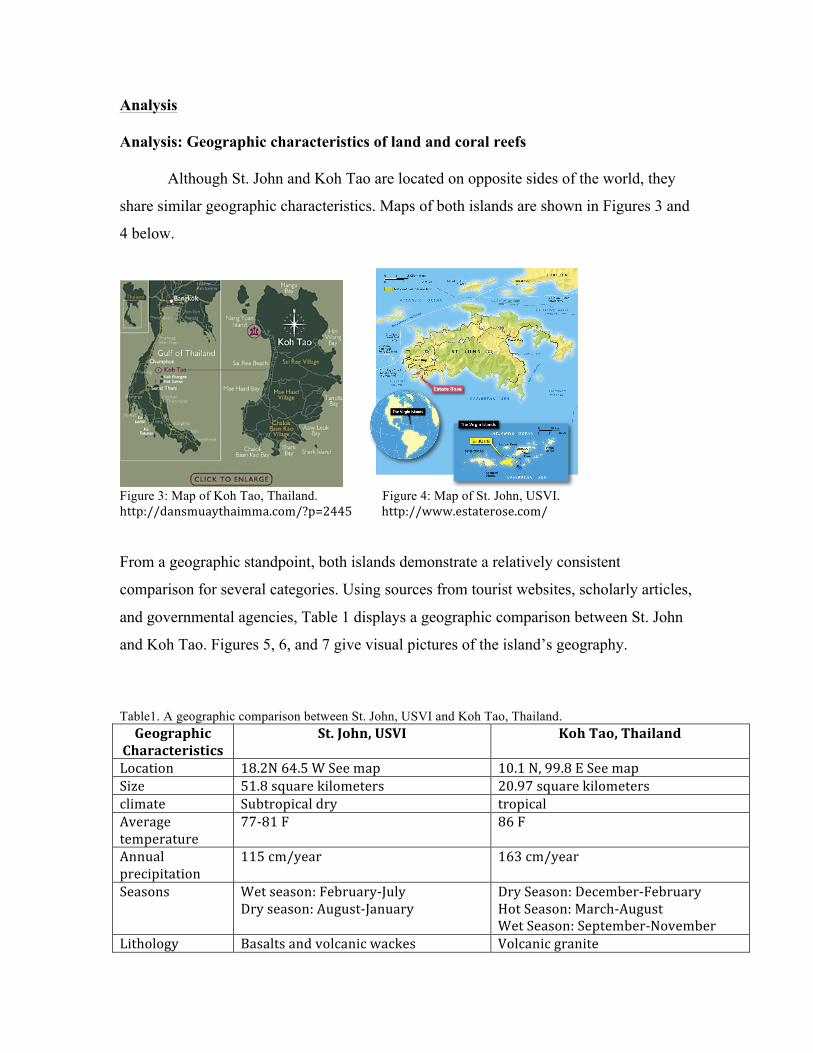
Analysis Analysis: Geographic characteristics of land and coral reefs Although St. John and Koh Tao are located on opposite sides of the world, they
share similar geographic characteristics. Maps of both islands are shown in Figures 3 and
4 below.
Figure 3: Map of Koh Tao, Thailand. Figure 4: Map of St. John, USVI. http://dansmuaythaimma.com/?p=2445 http://www.estaterose.com/ From a geographic standpoint, both islands demonstrate a relatively consistent
comparison for several categories. Using sources from tourist websites, scholarly articles,
and governmental agencies, Table 1 displays a geographic comparison between St. John
and Koh Tao. Figures 5, 6, and 7 give visual pictures of the island’s geography. Table1. A geographic comparison between St. John, USVI and Koh Tao, Thailand. Geographic
Characteristics St. John, USVI Koh Tao, Thailand
Location 18.2N 64.5 W See map 10.1 N, 99.8 E See map Size 51.8 square kilometers 20.97 square kilometers climate Subtropical dry tropical Average temperature
77-‐81 F 86 F
Annual precipitation
115 cm/year 163 cm/year
Seasons Wet season: February-‐July Dry season: August-‐January
Dry Season: December-‐February Hot Season: March-‐August Wet Season: September-‐November
Lithology Basalts and volcanic wackes Volcanic granite
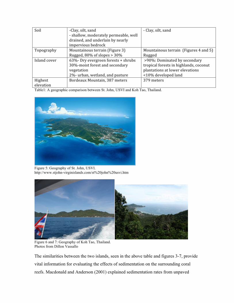
Soil -‐Clay, silt, sand -‐ shallow, moderately permeable, well drained, and underlain by nearly impervious bedrock
-‐ Clay, silt, sand
Topography Mountainous terrain (Figure 3) Rugged, 80% of slopes > 30%
Mountainous terrain (Figures 4 and 5) Rugged
Island cover 63%-‐ Dry evergreen forests + shrubs 30%-‐moist forest and secondary vegetation 2%-‐ urban, wetland, and pasture
>90%: Dominated by secondary tropical forests in highlands, coconut plantations at lower elevations <10% developed land
Highest elevation
Bordeaux Mountain, 387 meters 379 meters
Table1: A geographic comparison between St. John, USVI and Koh Tao, Thailand.
Figure 5: Geography of St. John, USVI. http://www.stjohn-virginislands.com/st%20john%20usvi.htm
Figure 6 and 7: Geography of Koh Tao, Thailand. Photos from Dillon Vassallo The similarities between the two islands, seen in the above table and figures 3-7, provide
vital information for evaluating the effects of sedimentation on the surrounding coral
reefs. Macdonald and Anderson (2001) explained sedimentation rates from unpaved
roads on St. John depend greatly on the slope of the terrain, precipitation, and storm
intensity. Parallels exist between the volcanic mountainous terrains on both islands. Both
islands feature a maximum elevation point just below 400 meters, and similarities in their
topography can be seen in images of the islands. (Haad Tien, 2012). Koh Tao gets about
50 more centimeters of rain on average per year, and both islands have a dry and wet
season and are characterized as a tropical climate (Thai Meteorological Department,
2006). On Koh Tao, the wet season consists of torrential downpours and tropical storms
from the northeast monsoon winds. The precipitation usually comes in fast, heavy
showers with large amounts of rainfall. The precipitation in November averages more
than twice any other month, with October being the second highest precipitation month
(Holiday Weather, 2012). Many roads on Koh Tao wash out completely, and parts of the
island can only be accessed by boat during the wet season (Visit Thailand, 2007). As
noted, storm intensity plays a vital role in the sedimentation rate from unpaved roads
(Ramos-Scharron and MacDonald, 2005). The geographic parallels on both islands offers
evidence to the possibility of Koh Tao having major sedimentation flows from unpaved
road segments.
Similarly, the coral reefs on Koh Tao hold many similar characteristics of the
reefs around St. John. As seen in Figure 3, a high number of bays surround the coastline
of Koh Tao. All bays contain coral reef ecosystems, and over 25 dive sites exist around
the island. Most coral reef dive sites are located within 50 meters from shore,
demonstrating the reef locations exist right off of the coastal land (See Figure 12).
Average depth of dive site reefs equal 14 meters, yet many coral ecosystems around Koh
Tao begin right along the coastline at much shallower depths (Koh Tao Info, 2002).
Similar to Koh Tao, St. John also has several shallow bay areas, with large reef patches
surrounding the island. Rogers (1990) explains an individual reef threat from
sedimentation can be based on “the amount of sediment which will be introduced into the
reef environment, the coral community composition, the depth of the reef, the percent
coral cover, and the current patterns”. Additionally, “reefs in poorly flushed semi-
enclosed bays or lagoons, and reefs surrounded by a shallow sea floor, are at greatest risk
of degradation, probably because materials are retained for prolonged periods of time,
extending the period of exposure to more ‘chronic’ conditions” (ISRS, 2004). Both St.

John and Koh Tao’s reef ecosystems possess the characteristics to make them highly
threatened from sedimentation (Save Koh Tao, 2012, Ramos-Scharron and MacDonald,
2005). Koh Tao and other southern islands in Thailand recently lost over a third of their
coral reefs from sediment (Sarnsamak, 2012). Similarly, the largest threat to coral reefs
on St. John is sedimentation (Ramos-Scharron and Macdonald, 2007). Sedimentation
poses as a major threat to the coral reefs of both islands because of their mountainous
terrain, heavy rainfall, and volcanic properties. However, where does the sediment come
from? In Thailand, studies found land development and coastal expansion to be the main
cause of sedimentation onto the reefs, but no research looked further into the analysis to
determine what parts of the expansion contributed the most (Sarnsamak, 2012). However,
on St. John, studies show the unpaved road network to be the main source of
sedimentation onto the reefs (Ramos-Scharron and Macdonald, 2005). While the
geography of both islands prove very similar, their road networks must be compared to
determine whether or not unpaved roads play a vital role in the destruction of coral reefs
from sedimentation on Koh Tao.
Analysis: Historical development and unpaved roads
Roads alter the natural processes of water storage and distribution on a landscape.
Roads increase the frequency and magnitude of surface runoff because they create a
compacted, low-permeability surface (Bren and Leitch, 1985), and also affect runoff
because they intercept subsurface flows and disrupt natural drainage patterns (Dutton et
al., 2005). Unpaved roads greatly increase the rate of sedimentation, where materials
transport down the dirt road network during precipitation. Surface erosion rates are
generally many times higher than erosion rates from undisturbed hillslopes, especially on
steep mountainous terrains, like St. John and Koh Tao (Ramos-Scharron and Macdonald,
2005).
Due to a tourism boom and rapid expansion on St. John, the density of roads
greatly increased over the past 30 years. For example, from 1971 to 2000, the road
network expanded around Fish Bay basin from 6.0 square kilometers to 23.2 square
kilometers (Ramos-Scharron and Macdonald, 2007). In 1980, the annual visitor rate to
the USVI was only 530,000, yet by 2009 the number of annual visitors reached almost
2.25 million (USVI Annual Tourism Indicators, 2010). In 2010, an estimated 110,000
people lived on the US Virgin Islands of St. Thomas, St. Croix, and St. John, and the
island welcomed an additional 2.6 million annual visitors. On St. John, the population
expanded by 171% from 2000 to 2008. Many private owners built homes high up in the
mountainous terrain, requiring long dirt road segments to be built for access (Crosset et
al., 2008). The rapid pace of expansion called for quick development schemes, and
minimal planning went into road and building construction on the steep slopes and highly
erosive soils of St. John. Further, a majority of developments on St. John “lack properly
designed and implemented storm water drainage plans, and most access is still provided
by a network of unpaved roads. These unpaved road systems have become both primary
sources of sediment and primary drainage conveyances, effectively transporting
sediment-laden runoff into sensitive coastal habitats” (VI RC&D, 2010). Many of the
steep unpaved road segments develop deep rills because of their poor drainage structures
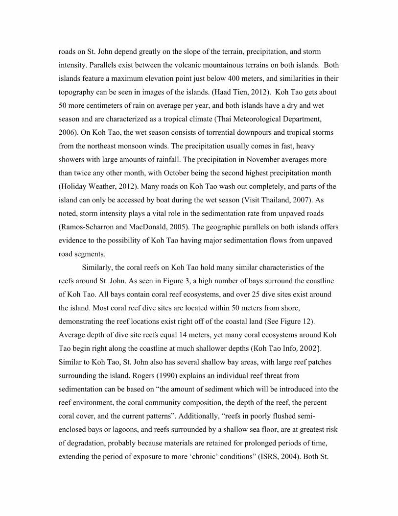
(Ramos-Scharron and MacDonald, 2007). Figure 8 displays the road segments of St.
John and their vulnerability to erosion based on slope, precipitation, and soil erodibility.
Figures 9-11 show satellite images of the road network and a visual photograph of a deep
rill and the poor unpaved road conditions on St. John.
Figure 8: Road vulnerability on St. John. (VI RC&D, 2010)
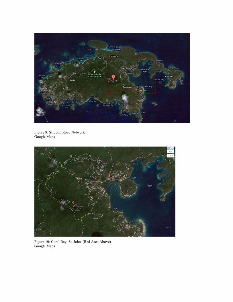
Figure 9: St. John Road Network. Google Maps
Figure 10: Coral Bay, St. John. (Red Area Above) Google Maps
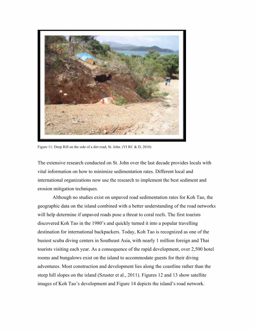
Figure 11: Deep Rill on the side of a dirt road, St. John. (VI RC & D, 2010)
The extensive research conducted on St. John over the last decade provides locals with
vital information on how to minimize sedimentation rates. Different local and
international organizations now use the research to implement the best sediment and
erosion mitigation techniques.
Although no studies exist on unpaved road sedimentation rates for Koh Tao, the
geographic data on the island combined with a better understanding of the road networks
will help determine if unpaved roads pose a threat to coral reefs. The first tourists
discovered Koh Tao in the 1980’s and quickly turned it into a popular travelling
destination for international backpackers. Today, Koh Tao is recognized as one of the
busiest scuba diving centers in Southeast Asia, with nearly 1 million foreign and Thai
tourists visiting each year. As a consequence of the rapid development, over 2,500 hotel
rooms and bungalows exist on the island to accommodate guests for their diving
adventures. Most construction and development lies along the coastline rather than the
steep hill slopes on the island (Szuster et al., 2011). Figures 12 and 13 show satellite
images of Koh Tao’s development and Figure 14 depicts the island’s road network.
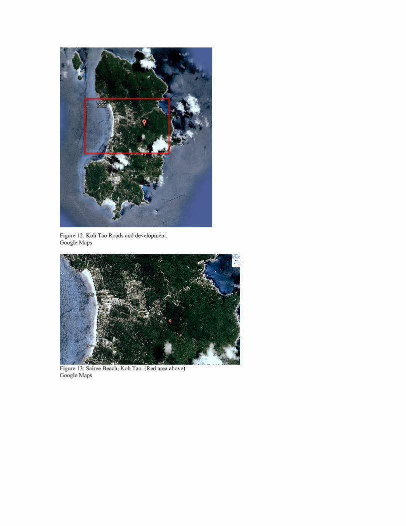
Figure 12: Koh Tao Roads and development. Google Maps
Figure 13: Sairee Beach, Koh Tao. (Red area above) Google Maps

Figure 14: The road network of Koh Tao. http://en.kohtaozone.com/images/koh-tao-roadmap-big.png A main paved road extends across the west coast, linking the north end of Sairee with
Chalok Baan Kao in the south. This major road passes through the main tourist village
and transportation hub, Mae Haad (seen in figure 13). The main road is the spinal column
for roads in Koh Tao, with all other roads extending off either down to Sairee Beach and
its resorts or up and over the mountains towards other bays. Almost all roads splitting off
the main road remain unpaved, except for a recent paved section towards Thian Ok Bay
(Koh Toa Zone, 2012). A Koh Tao tourist information site describes the unpaved dirt
roads as steep, consisting of sand and grit, and containing several fast curves, potholes,
and washed out tracks (Sawadee, 2012). Figure 15 shows an image of a section of
unpaved road in Koh Tao, and the effects from precipitation and runoff.
Main Roads (paved) Recommended routes (unpaved) Secondary roads (unpaved, poor) Paths/ difficult routes (no car access)
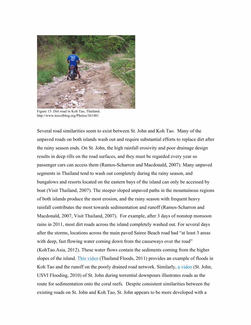
Figure 15: Dirt road in Koh Tao, Thailand. http://www.travelblog.org/Photos/361481 Several road similarities seem to exist between St. John and Koh Tao. Many of the
unpaved roads on both islands wash out and require substantial efforts to replace dirt after
the rainy season ends. On St. John, the high rainfall erosivity and poor drainage design
results in deep rills on the road surfaces, and they must be regarded every year so
passenger cars can access them (Ramos-Scharron and Macdonald, 2007). Many unpaved
segments in Thailand tend to wash out completely during the rainy season, and
bungalows and resorts located on the eastern bays of the island can only be accessed by
boat (Visit Thailand, 2007). The steeper sloped unpaved paths in the mountainous regions
of both islands produce the most erosion, and the rainy season with frequent heavy
rainfall contributes the most towards sedimentation and runoff (Ramos-Scharron and
Macdonald, 2007, Visit Thailand, 2007). For example, after 3 days of nonstop monsoon
rains in 2011, most dirt roads across the island completely washed out. For several days
after the storms, locations across the main paved Sairee Beach road had “at least 3 areas
with deep, fast flowing water coming down from the causeways over the road”
(KohTao.Asia, 2012). These water flows contain the sediments coming from the higher
slopes of the island. This video (Thailand Floods, 2011) provides an example of floods in
Koh Tao and the runoff on the poorly drained road network. Similarly, a video (St. John,
USVI Flooding, 2010) of St. John during torrential downpours illustrates roads as the
route for sedimentation onto the coral reefs. Despite consistent similarities between the
existing roads on St. John and Koh Tao, St. John appears to be more developed with a
larger unpaved road network extending more consistently into the mountainous terrain of
the island.
Although Koh Tao drastically expanded from tourism over the past few decades,
there remains a strong possibility of continued development on the island. Most home,
hotel, and bungalow locations rest along the coast rather than along the steep slopes of
the island. As the island gains more and more popularity, inland development will
inevitably occur. More roads will need to be constructed to connect the developments
with the rest of the island. As seen in the satellite images and road network maps above,
St. John is more developed with a larger quantity of dirt roads expanding into the heart of
the island and mountains. Several vacation homes and hotels on St. John are built directly
into the mountainside, and these owners build private roads to connect themselves with
the road network on the island (VI RC & D, 2010). Coral Bay, St. John, provides an
excellent example of significant development, the use of unpaved road networks to
accommodate rapid expansion, and the ensuing runoff and sedimentation onto coral reefs.
Coral Bay represents the largest sub-watershed draining into an individual bay on
St. John. Figure 10 above displays a satellite image of the bay, while Figure 16 below
shows the different watersheds draining into Coral Bay, and the unpaved and paved road
network can be seen in Figure 17. Figure 18 provides evidence of the runoff in a section
of the bay named Coral Harbor, with several homes and hotels located high up in the
mountains.
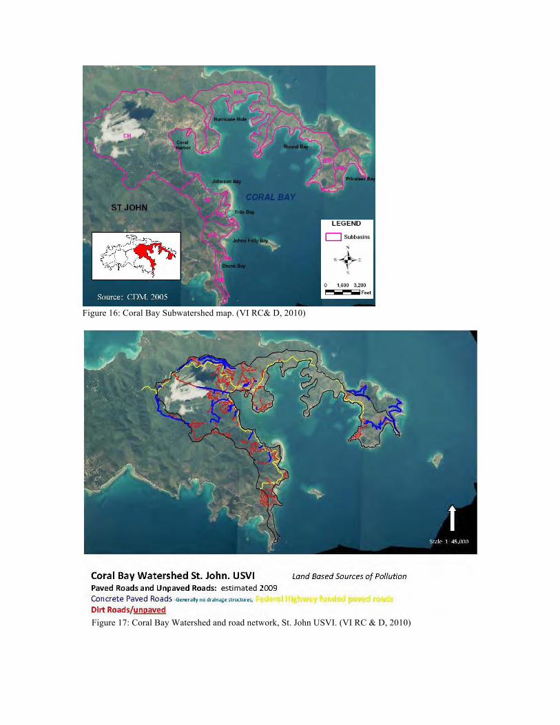
Figure 16: Coral Bay Subwatershed map. (VI RC& D, 2010)
Figure 17: Coral Bay Watershed and road network, St. John USVI. (VI RC & D, 2010)
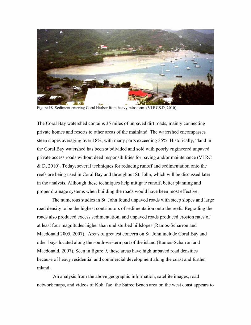
Figure 18. Sediment entering Coral Harbor from heavy rainstorm. (VI RC&D, 2010) The Coral Bay watershed contains 35 miles of unpaved dirt roads, mainly connecting
private homes and resorts to other areas of the mainland. The watershed encompasses
steep slopes averaging over 18%, with many parts exceeding 35%. Historically, “land in
the Coral Bay watershed has been subdivided and sold with poorly engineered unpaved
private access roads without deed responsibilities for paving and/or maintenance (VI RC
& D, 2010). Today, several techniques for reducing runoff and sedimentation onto the
reefs are being used in Coral Bay and throughout St. John, which will be discussed later
in the analysis. Although these techniques help mitigate runoff, better planning and
proper drainage systems when building the roads would have been most effective.
The numerous studies in St. John found unpaved roads with steep slopes and large
road density to be the highest contributors of sedimentation onto the reefs. Regrading the
roads also produced excess sedimentation, and unpaved roads produced erosion rates of
at least four magnitudes higher than undisturbed hillslopes (Ramos-Scharron and
Macdonald 2005, 2007). Areas of greatest concern on St. John include Coral Bay and
other bays located along the south-western part of the island (Ramos-Scharron and
Macdonald, 2007). Seen in figure 9, these areas have high unpaved road densities
because of heavy residential and commercial development along the coast and further
inland.
An analysis from the above geographic information, satellite images, road
network maps, and videos of Koh Tao, the Sairee Beach area on the west coast appears to
be the most populated area, with development and unpaved roads pushing further into the
island (seen in figures 12 and 13). Drawing from the information found in St. John
studies, the reefs off of Sairee Beach and its bay can be considered at great risk from
sedimentation. Another area for concern appears to be the bays located on the southeast
part of Koh Tao. These two areas display steep slopes, high road density, shallow reef
systems, and the most developed areas on the island. Paired with heavy rainfall, an
annual precipitation rate higher than St. John, and a majority of dirt roads, the analysis
provides evidence of sedimentation being a major threat to the reefs in these two areas.
Other areas of the island, especially inland, remain fairly untouched with minimal roads
and development, and sedimentation appears to pose less of a threat to coral reefs in these
areas. However, as the population and annual visitor numbers increase, these areas may
be subject to future development with denser unpaved road networks.
Several organizations in St. John (including the Virgin Islands Department of
Planning & Natural Resources, Virgin Islands Resources Conservation and Development
Council, Coral Reef Alliance, and International Society For Reef Studies) developed Best
Management Practices for controlling runoff related to roads, and these strategies now
exist throughout the island. The techniques, developed on land, help prevent
sedimentation from ever reaching the reefs, and should be used in Koh Tao for better reef
conservation. With a collaborative effort at a local scale, sedimentation rates on
individual reefs can be significantly reduced.
The most effective way to reduce runoff from roads relates to preserving existing
vegetation and replanting unused roads (VI RC&D, 2010). However, roads will
inevitably exist, and the best way to prevent runoff is paving roads. This action requires
substantial amounts of money (over $2 million per mile in St. John (VI RC& D, 2010)),
and may not be economically feasible for all roads. The Virgin Islands Department of
Planning & Natural Resources developed a guide on sediment and erosion control for the
island with emphasis on techniques to mitigate sedimentation from unpaved roads. Some
of the best practices included cross drains, broad-based dips, water turn-outs, and pipe
culverts (Division of Environmental Protection, 2010). These techniques divert runoff
from the surface of a dirt road to a more stable and vegetated area, preventing travel
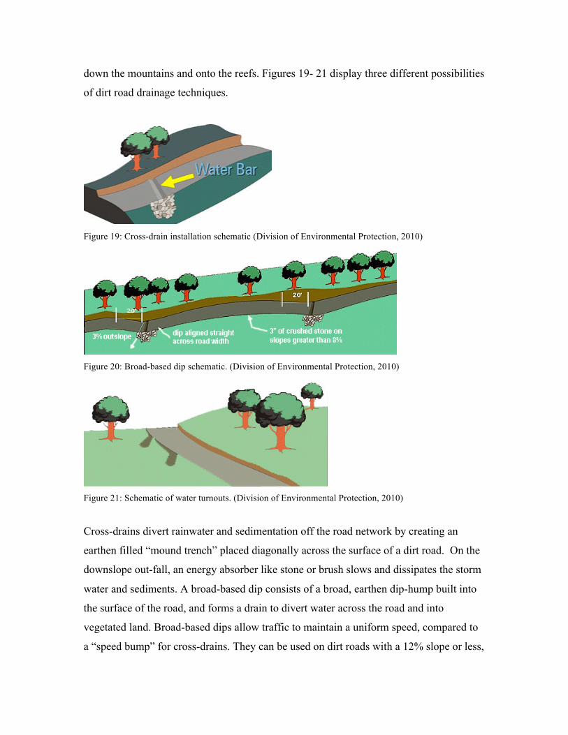
down the mountains and onto the reefs. Figures 19- 21 display three different possibilities
of dirt road drainage techniques.
Figure 19: Cross-drain installation schematic (Division of Environmental Protection, 2010)
Figure 20: Broad-based dip schematic. (Division of Environmental Protection, 2010)
Figure 21: Schematic of water turnouts. (Division of Environmental Protection, 2010)
Cross-drains divert rainwater and sedimentation off the road network by creating an
earthen filled “mound trench” placed diagonally across the surface of a dirt road. On the
downslope out-fall, an energy absorber like stone or brush slows and dissipates the storm
water and sediments. A broad-based dip consists of a broad, earthen dip-hump built into
the surface of the road, and forms a drain to divert water across the road and into
vegetated land. Broad-based dips allow traffic to maintain a uniform speed, compared to
a “speed bump” for cross-drains. They can be used on dirt roads with a 12% slope or less,
while cross-drains work best for heavier sloped road segments. Water turnouts divert
storm water away from a road surface with ditches, trenches, and swales. The turnouts
dissipate the water and sediments into the forest or stabilized grass area.
Cross-drains, broad-based dips, and water turnouts provide basic
recommendations for Koh Tao in developing a land-based approach to reduce
sedimentation onto its reefs. While other techniques exist, these three approaches are
cost-effective and fairly easy to maintain, and may be a good option for Koh Tao’s
current road system. In future years, Koh Tao should implement strategies like these
when developing new road segments on the islands.
Conclusion
This study provides evidence of the similarities between the islands of St. John
and Koh Tao. The geographic characteristics, reef dynamics, and unpaved road networks
of the two islands show consistent parallels. As mentioned, sedimentation from unpaved
roads can be considered the largest threat to St. John’s coral reefs. The above analysis
proves sedimentation from unpaved roads a very high threat around the reefs of Koh Tao
as well. Although St. John now uses existing studies to implement the best management
strategies to reduce runoff before reaching the reefs, Koh Tao’s approach to coral reef
conservation involves only working in the water, without minimizing sedimentation rates
on land. The paper suggests Koh Tao should use the information provided from St. John
to develop a reef conservation effort, attacking both sea and land-based sources of
pollution. As Koh Tao continues to develop in future years, the sedimentation from
unpaved roads will become more and more of a threat to its reefs. By following the
approaches from St. John, and understanding the mistakes the island made in
development, Koh Tao can work at finding a solution to its current runoff problems, and
use strategies to properly construct future roads to minimize sediment threats to its coral
reefs. Rather than waiting for coral reef threats to reach the reef, Koh Tao might instead
take a proactive approach on land, use the same strategies of St. John, and reduce the
sedimentation from unpaved roads before the sediment damages the coral reefs.
References Anderson, D. and L. Macdonald. 1998. Modeling road surface sediment production using a vector geographic information system. Earth Surface Processes and Landforms 23: pages 95-107. Ban, N., Adams, V., Almany, G., Ban, S., Cinner, J., McCook, L., Mills, M., Pressey, R., and A. White. 2011. Designing, implementing and managing marine protected areas: Emerging trends and opportunities for coral reef nations. Journal of Experimental Marine Biology and Ecology 1: pages 21-31. Bren, L. and C. Leitch. 1985. Hydrologic effects of a stretch of forest road. Australian Forest Research 15: pages 183-194. Burke, L., Reytar, K., Spalding, M., and A. Perry. 2011. Reefs at Risk Revisited. World Resources Institute, Washington DC. Available at http://pdf.wri.org/reefs_at_risk_revisited_executive_summary.pdf. Viewed on March 16, 2012.
Brown, B, Clark, K., and R. Warwick. Serial patterns of biodiversity change in corals across shallow reef flats in Ko Phuket, Thailand, due to the effects of local (sedimentation) and regional (climatic) perturbations. Marine Biology 1: pages 21-29.
Cesar, H., Burke, L., and L. Pet-Soede, 2003. The Economics of Worldwide Coral Reef Degradation. Cesar Environmental Economics Consulting, Arnhem, and WWF-Netherlands, Zeist, The Netherlands: pages 1-23.
Crossett, K.M., C.G. Clement, S.O. Rohmann. 2008. Demographic Baseline Report of U.S. Territories and Counties Adjacent to Coral Reef Habitats. Silver Spring, MD: NOAA, National Ocean Service, Special Projects: Pages 46-51.Available at http://coris.noaa.gov/activities/coral_demographics/coral_demographics_lo_res.pdf. Viewed on March 30, 2012. Coral Reef Alliance. 2010. Threats to Coral Reefs. Available at http://www.coral.org/resources/about_coral_reefs/threats_to_coral_reefs. Viewed on February 28, 2012.
Chansang, H., Boonyanate,P., and M. Charuchinda. 1981. Effect of sedimentation from coastal mining on coral reefs on the northwester coast of Phuket Island, Thailand. International coral Reef Symposium. Available at http://beta.searca.org/searca/. Viewed on February 28, 2012. Dutton, A., Loague, K., and B. Wemple. 2005. Simulated effects of a forest road on near-surface hydrologic response and slope stability. Earth Surface Processes and Landforms 30: pages 325-338.
Eco Koh Tao Conservation Group. 2012. Available at http://www.ecokohtao.com/. Viewed on March 16, 2012. Fahey, B. and R. Coker. 1992. Sediment production from forest roads in Queen Charlotte Forest and potential impact on marine water quality, Marlborough Sounds New Zealand. New Zealand Journal of Marine and Freshwater Research 26: pages 187-195. Gumbs, F., and J. Lindsay. 1982. Runoff and soil in Trinidad under different crops and soil management. Soil Science Society of America 46: pages 1264-1266. Haad Tien. 2012. The haad tien beach resort, Koh Tao. Other island activities. Available at http://www.haadtien.com/landpage/activity_other.html. Viewed on March 24, 2012. Hence, J. 2008. Human activity is killing coral reefs in the Caribbean. Mongabay. Available at http://news.mongabay.com/2008/0108-hance_coral.html. Viewed on February 29, 2012. Holiday Weather. 2012. Koh Tao Weather. Available at http://www.holiday-weather.com/koh_tao/. Viewed on March 30, 2012. ISRS. 2004. The effects of terrestrial runoff of sediments, nutrients and other pollutants on coral reefs., International Society for Reef Studies. Briefing Paper 3: pages 18-36. Available at http://www.coralreefs.org/documents/ISRS%20Briefing%20Paper%203%20-%20Water%20Quality.pdf. Viewed on February 28, 2012. IUCN. 2010. Global ocean protection: present status and future possibilities. Available at http://www.iucn.org/knowledge/publications_doc/publications/?6500/Global-ocean-protection--present-status-and-future-possibilities/. Viewed on February 28, 2012. Jibson, R.W. 1989. Debris flows in southern Puerto Rico. Geological Society of America, Special Paper 236: pages 29-55. Keller, B., Gleason, D., McLeod, E., Woodley, C., Airame, S. Causey, B. Friedlander, A. Dunsmore, R., Johnson, J., Miller, S., and R. Steneck. 2009. Climate change, coral reef ecosystems, and management options for marine protected areas. Environmental Management 44: pages 1069-1088. KohTao.Asia. 2012. Floods in Koh Tao,Koh Samui and Souther Thailand after torrential rains. Available at http://www.kohtao.asia/news/thailand-news/floods-in-koh-tao,-koh-samui-and-southern-thailand-after-torrential-rains..html. Viewed on March 30, 2012. Koh Tao Info. 2002. Exploring dive sites. Available at http://www.kohtaoonline.com/divesites.htm. Viewed on March 30, 2012.
Koh Tao Zone. 2012. Koh Tao Identity Card. Available at http://en.kohtaozone.com/dec/guide.php. Viewed on March 30, 2012. Larsen, M. and J. Parks. 1997. How wide is a road? The association of roads and mass- wasting in a forested montane environment. Earth Surface Processes and Landforms 22: pages 835-848. Marine Conservation Koh Tao. 2012. Save Koh Tao marine Branch. Available at http://www.marineconservationkohtao.com/. Viewed on March 16, 2012. Macdonald, L., Sampson, R., and D. Anderson. 2001. Runoff and road erosion at the plot and road segment scales, St. John, US Virgin Islands. Earth Surface Processes and Landforms 26: pages 251-272. McClanahan, T., Marnane, M., Cinner, J., and W. Kiene. 2006. A comparison of Marine Protected Areas and alternative approaches to coral-reef management. Current Biology 16: pages 1408-1413. Mongabay. 2007. Coral cover declines by 50% since 1980: Coral reefs declining faster than rainforests. Available at http://news.mongabay.com/2007/0808-coral.html. Viewed on April 9, 2012. Mumby, P., and Robert Steneck. 2008. Coral reef management and conservation in light of rapidly evolving ecological paradigms. Trends in Ecology & Evolution 10: pages 555-563. Ramos-Scharron, C. 2010. Sediment production from unpaved roads in a sub-tropical dry setting- Southwestern Puerto Rico. Catena 82: pages 146-158. Ramos-Scharron, C. and Lee MacDonald. 2007. Measurement and prediction of natural and anthropogenic sediment sources, St. John, U.S. Virgin Islands. ScienceDirect 71: pages 250-266. Ramos-Scharron, C., and L. MacDonald. 2006. Runoff and suspended sediment yields from an unpaved road segment, St John, US Virgin Islands. Hydrological Processes 21: pages 35-50. Ramos-Scharron, C. and L. MacDonald. 2005. Measurement and prediction of sediment production from unpaved roads, St John, US Virgin Islands. Earth Surface Processes and Landforms 30: pages 1283-1304. Rogers, C. 1990. Responses of coral reefs and reef organisms to sedimentation. Marine Ecology Progress Series 62: Pages 185-202. Sale, P. 2008. Management of coral reefs: Where we have gone wrong and what we can do about it. Marine Pollution Bulletin 5: pages 805-809.
Sarnsamak, P. 2012. A third of coastal reefs destroyed by sediment. The Nation. Available at http://www.nationmultimedia.com/national/A-third-of-coastal-reefs-destroyed-by-sediment-30178295.html. Viewed on March 30, 2012. Sawadee Koh Tao. 2012. Koh Tao & Koh Nant Yuan hotels and travel guide, Thailand.Transportation. Available at http://kohtao.sawadee.com/kohtao_transfer.html. Viewed on March 30, 2012. Save Koh Tao Conservation group. 2012. Available at http://www.savekohtao.com/. Viewed on March 16, 2012. St. John, USVI Flooding, 21 July 2010. 2010. Available at http://www.youtube.com/watch?v=XPLctpAU5MA. Viewed on April 9, 2012. Szuster, B., Chen, Q., and M. Borger. 2011. A comparison of classification techniques to support land cover and land use analysis in tropical coastal zones. Applied Geography 31: pages 525-532. Thai Meteorological Department. 2006. 30 year temperature and rainfall average, Surat Thani. Available at http://www.tmd.go.th/en/province_stat.php?StationNumber=48551. Viewed on March 30, 2012. Thailand floods! A walk around Koh Tao. 2011. Available at http://www.youtube.com/watch?v=2Z-rhmcHCIc. Viewed on April 9, 2012. Tirado, G., M. Lugo-Lopez. 984. Erosion on the hillsides of the Dominican Republic. University of Puerto Rico Journal of Agriculture 68: 117-119. Division of Environmental Protection. 2010. Sediment and erosion control on construction sites field guide. University of the Virgin Islands Cooperative Extension Service. Available at http://www.coralreef.gov/transportation/sederosuvi.pdf. Viewed on February 28, 2012. USVI Annual Tourism Indicators. 2010. USVI bureau of economic research, Office of the Governor. Available at http://www.usviber.org/pdfs/TOUR09.pdf. Viewed on March 30, 2012. VI CB&D.Virgin Island Coral Bay Community Council. 2010. Coral Bay Watershed Stabilization Workplan Summary Update. Available at http://www.coralbaycommunitycouncil.org/CB%20WorkPlan-Summary-NOAA-Recovery-Act-Jan-2010.pdf. Viewed on February 28, 2012. Virgin Island Coral Bay Community Council. 2010. VI RC & D. Coral Bay Watershed Stabilization Workplan Summary Update. Available at

http://www.coralbaycommunitycouncil.org/CB%20WorkPlan-Summary-NOAA-Recovery-Act-Jan-2010.pdf. Viewed on February 28, 2012. Visit Thailand. 2007. Koh Tao. Available at http://www.visit-thailand.net/Home.aspx. Viewed on March 30, 2012. Yeemin, T., Sutthacheep, M., and R. Pettongma. 2006. Coral reef restoration projects in Thailand. Ocean & Coastal Management 49: pages 562-575. Ziegler, A., Sutherland, R. and T. Giambelluca. 2001. Interstorm surface preparation and sediment detachment by vehicle traffic on unpaved mountain roads. Earth Surface Processes and landforms pages 26: 235-250.WF-