the distribution, classification and conservation of … no.19_rainforests e... · distribution,...
TRANSCRIPT

2006
THE DISTRIBUTION, CLASSIFICATION AND CONSERVATION OF RAINFORESTS IN
EASTERN ZIMBABWE
Tom Müller
Occasional Publications in Biodiversity No.19

THEDISTRIBUTION, CLASSIFICATION AND
CONSERVATION OF RAINFORESTSIN EASTERN ZIMBABWE
Tom Müller2006
Originally prepared as a consultancy report forthe Zimbabwe Forestry Commission in June 1994
Occasional Publications in Biodiversity No. 19
Biodiversity Foundation for AfricaP.O. Box FM 730, Famona, Bulawayo, Zimbabwe
Distribution and Classification of Rainforest in Eastern Zimbabwe — T. Müller page 1
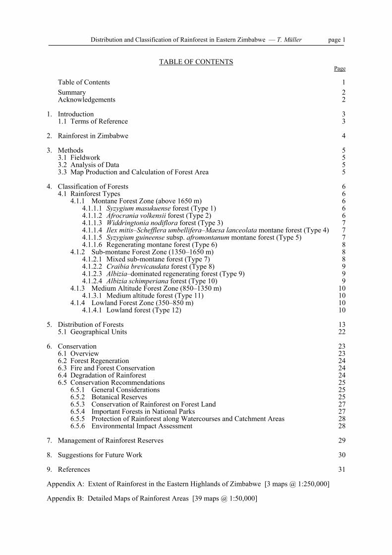
TABLE OF CONTENTSPage
Table of Contents 1Summary 2Acknowledgements 2
1. Introduction 31.1 Terms of Reference 3
2. Rainforest in Zimbabwe 4
3. Methods 53.1 Fieldwork 53.2 Analysis of Data 53.3 Map Production and Calculation of Forest Area 5
4. Classification of Forests 64.1 Rainforest Types 6
4.1.1 Montane Forest Zone (above 1650 m) 64.1.1.1 Syzygium masukuense forest (Type 1) 64.1.1.2 Afrocrania volkensii forest (Type 2) 64.1.1.3 Widdringtonia nodiflora forest (Type 3) 74.1.1.4 Ilex mitis–Schefflera umbellifera–Maesa lanceolata montane forest (Type 4) 74.1.1.5 Syzygium guineense subsp. afromontanum montane forest (Type 5) 74.1.1.6 Regenerating montane forest (Type 6) 8
4.1.2 Sub-montane Forest Zone (1350–1650 m) 84.1.2.1 Mixed sub-montane forest (Type 7) 84.1.2.2 Craibia brevicaudata forest (Type 8) 94.1.2.3 Albizia–dominated regenerating forest (Type 9) 94.1.2.4 Albizia schimperiana forest (Type 10) 9
4.1.3 Medium Altitude Forest Zone (850–1350 m) 104.1.3.1 Medium altitude forest (Type 11) 10
4.1.4 Lowland Forest Zone (350–850 m) 104.1.4.1 Lowland forest (Type 12) 10
5. Distribution of Forests 135.1 Geographical Units 22
6. Conservation 236.1 Overview 236.2 Forest Regeneration 246.3 Fire and Forest Conservation 246.4 Degradation of Rainforest 246.5 Conservation Recommendations 25
6.5.1 General Considerations 256.5.2 Botanical Reserves 256.5.3 Conservation of Rainforest on Forest Land 27
6.5.4 Important Forests in National Parks 276.5.5 Protection of Rainforest along Watercourses and Catchment Areas 286.5.6 Environmental Impact Assessment 28
7. Management of Rainforest Reserves 29
8. Suggestions for Future Work 30
9. References 31
Appendix A: Extent of Rainforest in the Eastern Highlands of Zimbabwe [3 maps @ 1:250,000]
Appendix B: Detailed Maps of Rainforest Areas [39 maps @ 1:50,000]

Distribution and Classification of Rainforest in Eastern Zimbabwe — T. Müller page 2
SUMMARY
The distribution and a classification of the rainforest patches in Eastern Zimbabweis presented, based on air photo interpretation and extensive field work. Twelveforest types are described based on their woody species composition. Altitude wasfound to be the major gradient.
The outlines of the forest patches are shown on 1:50,000 maps, and each patch orgroup of patches is numbered and described. Total forest area was found to be 107km2, the majority of this being in the Nyanga area.
Areas of particular interest for conservation are pointed out and conservationpriorities outlined. Brief management recommendations are also given.
ACKNOWLEDGEMENTS
This report was originally done as a consultancy for the Research and Development Division ofthe Zimbabwe Forestry Commission in June 1994. It is the summary of two years of fieldwork,mostly carried out by the author in the 1970s as part of a wider study into rainforest distributionand composition in Eastern Zimbabwe carried out under the National Herbarium and BotanicGarden of Zimbabwe, Harare. The author wishes to acknowledge support given during thatinitial study by the Department of Research and Specialist Services of the Ministry ofAgriculture. He also wishes to thank Jonathan Timberlake for help with the maps andpreparation for publication.
The Biodiversity Foundation for Africa wishes to thank the Divisional Manager of the ForestryCommission Research Division for permission to publish this valuable report as part of its seriesof papers documenting the biodiversity of south-central Africa.

Distribution and Classification of Rainforest in Eastern Zimbabwe — T. Müller page 3
1. INTRODUCTION
The distribution of rainforest in the Eastern Districts of Zimbabwe is not fully known. There isalso no classification available of the different rainforest types which can be recognised inaccordance with environmental gradients. The Forestry Commission of Zimbabwe has thereforerequested a consultancy which utilises existing unpublished information and personal fieldknowledge to classify and map the forests and also to make recommendations on conservationpriorities. The resulting report is intended to serve as an initial base for biodiversity conservationof the rainforest biomes, and also to avoid the danger of removing forests without clearknowledge of their importance.
1.1 Terms of Reference
a) Using existing annotated air photos, transfer interpreted extents of all indigenous moistforest patches in the Eastern Highlands of Zimbabwe onto 1:50,000 and 1:250,000 scalemaps, and determine areas. Describe each area.
b) Prepare a classification of the above forests based on species composition using existingfield data, and allocate all forest patches shown to a forest type. Mention should also bemade of those forests known to be excessively disturbed.
c) Indicate which forest types and areas are of national or international priority forbiodiversity conservation, after suitably excluding those known to be excessivelydisturbed.
d) Describe in general terms what management practices should be employed or avoided inorder to enhance conservation value of the various forest types.

Distribution and Classification of Rainforest in Eastern Zimbabwe — T. Müller page 4
2. RAINFOREST IN ZIMBABWE
Rainforest is extremely localised in Zimbabwe, and is found mainly on the windward slopes ofmountains along the eastern border with Mozambique. It occurs between an altitude of 350 and2100 m with a disjunct distribution, and consists of over 350 fragments stretching in a north-south direction for approximately 250 km. The individual forests range in size from less than onehectare to a few square kilometres. There are three main centres of rainforest development, whichare (from north to south), the Nyanga mountains, the Vumba mountains and the mountains of theChimanimani District. Smaller forests occur between the main centres and also in ChipingeDistrict. Chirinda Forest makes up the southern end of the distribution. The total area coveredby rainforest is approximately 107 km2 (less than 0.028% of the country). If the steepness andundulating nature of the terrain on which forest is generally found is considered, the total areacould be regarded as in the region of 120-150 km2.
Where rainforest occurs, annual average rainfall is at least 1200 mm, with significantprecipitation (mist and rain, or rain only) during the dry season. The main environmentalvariables which control the species distribution and determine the species composition of thevarious forest types are altitude, amount of available water (especially during the dry season),disturbance by man and, to a lesser extent, soil type, aspect and topography.

Distribution and Classification of Rainforest in Eastern Zimbabwe — T. Müller page 5
3. METHODS
3.1 Fieldwork
The information on which much of this report is based was gathered during field work which wascarried out between 1976 and 1984. The work comprised a detailed investigation of 202 quarterhectare forest plots which were spread over the whole area where forest occurs. The positions ofthe plots was predetermined on air photos. In each sampling plot all the woody species with adiameter-at-breast height (dbh) of 8 cm and above were recorded. The species of the sapling andshrub layers and the ground cover were recorded using a Braun-Blanquet cover abundance rating.Epiphytes and bryophytes were also recorded. Soil samples were collected and all relevantenvironmental data were noted. The access routes to the sites often went through forest and thesewere used as transects along which the validity of newly developed hypotheses concerningspecies distribution in relation to environment was tested.
3.2 Analysis of Data
Analysis of the data was carried out with the aid of the computer programmes DECORANA(Detrended Correspondence Analysis; Ter Braak 1988) and TWINSPAN (Two-Way IndicatorSpecies Analysis; Hill 1979). However, no satisfactory analysis could be achieved by computeralone. The classification arrived at is essentially derived directly from the field sheets aided bycomputer-produced results and the experience gained from working in the forests.
3.3 Map Production and Calculation of Forest Area
All rainforest has been marked on air photos dating from 1965 and 1975, using field knowledgewhere appropriate. The outlines have been checked against the 1986 air photos and no significantchanges have been noted, except for some small forests mainly in communal lands which arediscussed later.
The forest distribution maps have been produced by transferring the forest outlines from the airphotos on to 1:50,000 maps. The map which shows, schematically, the extent of rainforest in theeastern Districts has been produced by transferring the forest outlines by eye from the 1:50,000maps on to the three relevant portions of 1:250,000 maps.
The extent of the area covered by rainforest was calculated from 1:50,000 maps by dot planimeterafter transferring the forest outlines from 1:25,000 aerial photographs dating from 1965 to 1975.A rough estimate of the extent of each forest type has been made. Since forest type boundariesdo not show up on aerial photographs it is impossible to make accurate estimates in cases wheretwo or more types occur in one forest patch. Where the forest type changes with altitude, contourlines have been used as type boundaries for the purpose of the estimate. Where two or more typesoccur in the same altitudinal zone, the estimate is based on notes made on site visits during fieldwork.

Distribution and Classification of Rainforest in Eastern Zimbabwe — T. Müller page 6
4. FOREST CLASSIFICATION
Altitude is the most important factor affecting the species composition of rainforest in Zimbabwe,and four major forest zones can be recognised based on it. Montane forest (above 1650 m), sub-montane forest (1350 to 1650 m), medium altitude forest (850 to 1350 m) and lowland forest (350to 850 m). The altitudinal limits are approximate and vary considerably in accordance with aspectand relief. For instance, on warmer western and northern slopes species generally confined tolower altitudes are found higher up, and on slopes which allow for easy downward movement ofcold air (long steep slopes) high altitude species are found further down the slopes than normal.
Using tree species composition as a criterion, the two upper zones can be divided into 10 foresttypes and the two lower zones are best considered as one type each. The majority of the forests,or portions of forests, can be classified with relative ease into recognisable and fairlyhomogeneous types. These, in turn, can be reconciled with the environment and repeatthemselves in similar environmental situations. However, some forests do no fit well into thegenerally observed pattern and there seems to be no obvious environmental reason for theseanomalies. There is evidence that many forests have been severely disturbed by man over severalcenturies which may be the reason for the difficulties in classification. The anomalies aredescribed either as variants of the type which they most resemble or as intermediates betweentypes where this seems appropriate.
4.1 Rainforest Types
The approximate extent of each forest type and its occurrence is summarised in Table 1.
4.1.1 MONTANE FOREST ZONE (above 1650 m)
Six montane forest types can be readily recognised.
4.1.1.1 Syzygium masukuense montane forest (Type 1, approximately 655 ha)
This is only found on the Nyangani massif, where it covers much of the area where forest canoccur between 1700 to 2050 m. Where the forest is least disturbed, Syzygium masukuenseaccounts for up to two thirds or more of the total tree cover. Other common canopy trees areAphloia theiformis, Cassipourea malosana, Ilex mitis, Podocarpus latifolius, Prunus africana,Rapanea melanophloeos and Schefflera umbellifera. No sub-canopy can be distinguished, butCanthium oligocarpum, Diospyros whyteana, Dovyalis lucida, Erythrococca polyandra, Pavettaumtalensis, Peddiea africana and Psychotria zombamontana are found as scattered small treesin the sapling layer. The shrub layer is dense and dominated by Justicia betonica, Peddieaafricana and Psychotria zombamontana. Towards drier sites, Syzygium masukuense is lessdominant and Aphloia theiformis, Curtisia dentata, llex mitis, Macaranga mellifera, Maesalanceolata, Rapanea melanophloeos and Schefflera umbellifera more prominent. Lower downthe slope the canopy is more mixed and species like Cryptocarya transvaalensis, Faurearacemosa, Olea hochstetteri, Pterocelastrus echinatus and Tabernaemontana stapfiana are morecommon. The canopy is 10 to 12 m in height with a few emergents up to 15 m, increasing toabout 15 m in height with emergents up to 20 m towards the lower boundary.
4.1.1.2 Afrocrania volkensii montane forest (Type 2, approximately 375 ha)
This is a distinct forest type with a limited distribution on Nyangani mountain, where it isconfined to wet boulder screes and the central portion of the high valleys, but is more extensiveon mountains in the south-west of Chimanimani District where it occurs on gentle upper slopesor broad high valleys. A few small patches are found in the highest part of the Banti ForestReserve. In the canopy Afrocrania volkensii can be dominant (Nyangani mountain) or co-dominant with Ilex mitis and Olea hochstetteri (Chimanimani District). Other common tree
Distribution and Classification of Rainforest in Eastern Zimbabwe — T. Müller page 7
species are Ekebergia capensis, Kiggelaria africana, and Prunus africana and Calpurnia aurea,Canthium pauciflorum subsp. angustifolium, Diospyros whyteana, Halleria lucida and Trimeriagrandiflora are typical of the ill-defined second layer. Peddiea africana, Psychotriazombamontana and Sclerochiton harveyanus (Chimanimani District only) dominate the shrublayer. Canopy height is up to 30 m and the forests are relatively undisturbed.
4.1.1.3 Widdringtonia nodiflora forest (Type 3, approximately 40 ha)
This type of forest is limited in extent and distribution, occurring on the Nyanga mountains andon some mountains in the Chimanimani District, mainly between 1 700 and 2 100 m. It isprincipally confined to fringing streams in rainshadow areas where it is often affected by fire.This forest consists almost exclusively of Widdringtonia nodiflora or contains occasionalspecimens of Curtisia dentata, Ilex mitis, Maesa lanceolata, Macaranga mellifera, Nuxiacongesta, Rapanea melanophloeos and Schefflera umbellifera. The height of the canopy rarelyexceeds 10 m and stratification is poorly developed. At the end of its development this forest ismore of a thicket consisting of scattered Widdringtonia nodiflora mixed with forest edge speciessuch as Buddleja salviifolia, Hypericum revolutum, Myrica pilulifera, Passerina montana, Ericahexandra, Stoebe vulgaris and others. Widdringtonia nodiflora forest can hardly be consideredrainforest proper in Zimbabwe and has only been mapped where it forms large stands andcontains some other rainforest species.
4.1.1.4 Ilex mitis - Schefflera umbellifera - Maesa lanceolata montane forest (Type 4,approximately 695 ha)
This is a forest type confined to areas where conditions are probably too dry for either of the twoSyzygium species to grow in abundance. It occurs mainly in small, often concave, patches or onridges within and above the upper end of Syzygium dominated forest from about 1700 m to2100 m (the upper end of rainforest development). Dominant canopy species are Aphloiatheiformis, Curtisia dentata, Faurea racemosa, Ilex mitis, Maesa lanceolata, Podocarpuslatifolius, Rapanea melanophloeos and Schefflera umbellifera. The forest type is extremelyvariable and could be considered an aggregate of sub-types. In different forests various of theabove species are dominant or some may be absent. Other typical or occasional trees areCassipourea malosana, Ekebergia capensis, Halleria lucida, Kiggelaria africana, Macarangamellifera, Syzygium guineense subsp. afromontanum and Tabernaemontana stapfiana. Diospyroswhyteana, Dovyalis lucida, Erythroxylum emarginatum, Pittosporum viridiflorum and Trimeriagrandifolia are common smaller trees. The shrub layer is, on the whole, similar to that ofSyzygium-dominated montane forest. Canopy height is variable, normally between 12 and 15 m,but can be up to 20 m with emergent specimens of 25 m. An interesting variant is the Podocarpuslatifolius forest which occurs in the upper portion of the Banti Forest Reserve.
4.1.1.5 Syzygium guineense subsp. afromontanum montane forest (Type 5,approximately 2420 ha)
On the Nyangani massif this forest type is found at slightly lower altitudes than the Syzygiummasukuense montane forest in the lower portion of the montane belt. Elsewhere it is the mainmontane forest type in areas where forest is relatively undisturbed and occurs up to about 1900 m. On some slopes it can reach into the sub-montane belt as low down as 1 500 m.
Normally the dominant canopy tree species is Syzygium guineense subsp. afromontanum. Aphloiatheiformis, Cassipourea malosana, Cryptocarya transvaalensis, Olea hochstetteri, Pterocelastrusechinatus and Rapanea melanophloeos are important associate species which can become co-dominant or even dominant in some areas. Other widespread trees are Apodytes dimidiata,Bersama swynnertonii, Croton sylvaticus, Ekebergia capensis, Ilex mitis, Kiggelaria africana andNuxia congesta. Curtisia dentata, Macaranga mellifera, Maesa lanceolata and Podocarpuslatifolius are often present and, together with Aphloia theiformis and Rapanea melanophloeos,increase towards drier sites and with increasing disturbance. The sub-canopy is well-developedand dominated by Tabernaemontana stapfiana, Dovyalis lucida, Erythroxylum emarginatum,Eugenia nyassensis, Oxyanthus speciosus, Pavetta umtalensis, Rawsonia lucida, Xymalos
Distribution and Classification of Rainforest in Eastern Zimbabwe — T. Müller page 8
monospora, Chionanthus foveolatus subsp. major, Ochna holstii and Oricia bachmannii. Thelatter three species can sometimes reach the canopy. Justicia betonica, Peddiea africana,Psychotria zombamontana and Sclerochiton harveyanus normally dominate the well-developedshrub layer. Canopy height increases with decreasing altitude from about 12 to 20 m, or even25 m, with emergent trees up to 30 m.
4.1.1.6 Regenerating montane forest (Type 6, approximately 1935 ha)
This forest type is particularly common in the Nyanga and Vumba mountains where large areasof rainforest are in different stages of recovery from having been cleared during past times. Allstages in between, from near- pristine Syzygium forest to forest which has been cleared asrecently as 100 years ago, can be found. The dominant tree species is normally Macarangamellifera, with Aphloia theiformis, Maesa lanceolata and Schefflera umbellifera often co-dominant. Polyscias fulva and Allophylus abyssinica can sometimes be fairly common, especiallyin the lower part of the montane belt. Aphloia theiformis dominates the sub-canopy, oftentogether with Xymalos monospora. Most of the tree species which occur in the montane belt canbe found in small numbers in regenerating forest. The shrub layer is generally similar to that inmature montane forest. The presence of Cassinopsis tinifolia, Hypericum revolutum and Myricapilulifera indicate young regenerating forest. The canopy consists of even-aged stands of treesand can be between 15 and 20 m in height with emergent specimens up to 25 m.
4.1.2 SUB-MONTANE FOREST ZONE (1350 to 1650 m).
This can be considered an ecotonal belt of forest consisting of a mixture of montane and mediumaltitude tree species, with the proportion of medium altitude species increasing with decreasingaltitude to about 50% or more in the lower parts. Four forest types can be distinguished in thiszone, but intermediates occur.
4.1.2.1 Mixed sub-montane forest (Type 7, approximately 2130 ha)
This is the most mesic forest type in this zone, and can reach as high as 1750 m on theChimanimani mountains, but more often the upper limit is between 1600 and 1650 m. On theVumba mountains mixed sub-montane forest is found immediately beneath the Syzygiumguineense subsp. afromontanum montane forest, but S. g. subsp. afromontanum is practicallyabsent. Elsewhere it is an important component of the canopy cover right down to the lower parts.Generally the canopy is fairly mixed. Common species are Cassipourea malosana, Nuxiacongesta, Oricia bachmannii, Podocarpus latifolius, Rapanea melanophloeos and Syzygiumguineense subsp. afromontanum from the montane zone, Cassipourea gummiflua, Chrysophyllumgorungosanum, Craibia brevicaudata subsp. baptistarum, Ficus chirindensis, F. craterostoma,F. scassellatii and Strombosia scheffleri from the medium altitude zone. A tree found in all fourzones, Croton sylvaticus is often prominent, and Ekebergia capensis, also found at all levels, issometimes present. Bersama swynnertonii and Margaritaria discoidea var. nitida are occasionaltree species which are mainly confined to this forest type. The sub-canopy is also composed ofmontane and medium altitude species. Aphloia theiformis, Diospyros whyteana, Erythroxylumemarginatum, Ochna holstii, Oricia bachmannii, Oxyanthus speciosus, Tabernaemontanastapfiana and Xymalos monospora are montane species, and Cola greenwayi, Englerodendronmagalismontanum, Garcinia kingaensis, Heinsenia diervilleoides, Myrianthus holstii, Rawsonialucida, Rothmannia urcelliformis and Vangueria esculenta are typical of medium altitude. Thecomposition of the sub-canopy varies considerably, and up to four or five of any of the abovespecies can be co-dominant. The most common species in the well developed shrub layer areJusticia betonica, Psychotria zombamontana, Peddiea africana and Sclerochiton harveyanus.Often there is a great variety of species in the shrub layer and up to 50 species have beenrecorded in the shrub layer of a 0.25 ha stand. Canopy height is from 25 to 35 m and emergentscan reach 40 m. In a mature forest of this type species richness for trees reaches its peak forZimbabwe. In a 0.25 ha stand 41 species with more than 8 cm dbh were recorded.

Distribution and Classification of Rainforest in Eastern Zimbabwe — T. Müller page 9
4.1.2.2 Craibia brevicaudata forest (Type 8, approximately 35 ha)
This forest type is fairly rare and is only found between 1400 and 1600 m and confined to graniteboulder screes. The canopy consists almost entirely of Craibia brevicaudata susbsp. baptistarum,with Ficus chirindensis and F. scassellatii as typical associates. Cassipourea malosana, C.gummiflua, Croton sylvaticus and the pioneer trees Albizia schimperiana, Macaranga melliferaand Polyscias fulva are occasionally present. Craibia brevicaudata subsp. baptistarum is alsodominant in the sub-canopy, with Dracaena steudneri, Rothmannia urcelliformis, Teclea nobiliscommon and Ritchiea albersii, Tabernaemontana stapfiana and Xymalos monosporaoccasionally present. The shrub layer is patchy and irregular and is mainly developed where thereare pockets of soil between boulders. The species composition is varied with Dracaena fragrans,Metarungia pubinervia, Peddiea africana sometimes common, but often a variety of young treesand climbers make up a substantial part of the shrub cover. Canopy height is 20 to 25 m,sometimes up to 30 m, with emergent fig trees up to 35 m.
4.1.2.3 Albizia-dominated regenerating forest (Type 9, approximately 380 ha)
Regenerating forest changes physiognomically below 1 600 m due to the appearance of Albiziagummifera and A. schimperiana as dominant canopy trees. A. schimperiana is common on driersites and A. gummifera common where there is more moisture. Sometimes these two species aremixed in various proportions. Other typical canopy trees are Celtis africana, Croton sylvaticus,Polyscias fulva, Rauvolfia caffra and Sapium ellipticum. Macaranga mellifera is still verycommon, either in the canopy or, more often, forming a high subcanopy immediately beneath theAlbizia crowns. Common smaller trees are Teclea nobilis and Xymalos monospora. In the upperparts of the zone Aphloia theiformis can still be common, and lower down Tarenna pavettoidessubsp. affinis is sometimes plentiful. In the early stages of regeneration Trema orientalis is oftenpresent. The shrub layer is well developed and similar to mixed sub-montane forest. The canopyheight of an Albizia-dominated forest can be up to 40 m high with emergent Albizias up to nearly50 m. This type of regenerating forest also occurs right through the medium altitude zone, downto about 1000 m.
4.1.2.4 Albizia schimperiana forest (Type 10, approximately 110 ha)
This is the driest type of rainforest before miombo woodland takes over. The transition tomiombo is sudden and sharp. The dominant canopy species is usually Albizia schimperiana. Asmoisture increases, A. gummifera becomes more common, sometimes even dominant. Othercharacteristic trees are Allophylus abyssinicus, Celtis africana, Ekebergia capensis, Ficus sur,Prunus africana and, occasionally, Croton sylvaticus. Curtisia dentata, Maesa lanceolata andSchefflera umbellifera can be common in the upper part of the zone. Typical lower story trees areDracaena steudneri, Kiggelaria africana, Ochna holstii, Pittosporum viridiflorum, Tecleanobilis, Trimeria grandifolia and Xymalos monospora. Towards the drier end of this forest type,forest-edge species such as Calodendrum capense, Erythrina lysistemon, Fagaropsis angolensis,Ficus thonningii, Olinia vanguerioides, Scolopia zeyheri, Schrebera alata and Terminaliagazensis become increasingly common and can reach the canopy. Here the canopy can be quitemixed with Albizia schimperiana less prominent. Smaller trees typical of the dry end of forestdevelopment are Bridelia micrantha, Canthium inerme, Cussonia spicata, Dais cotinifolia andRhus lucida. The shrub layer can be similar to that in mixed sub-montane forest at the wetter end,and rather patchy and diverse at the drier end, where it consists of a mixture of young trees,forest-edge shrubs, twiners, young climbers and typical forest shrubs.
Canopy height is similar to the Albizia-dominated regenerating forest, but can be as low as 20 or25 m where the Albizias are absent, and then the odd Albizia schimperiana emergesconspicuously.

Distribution and Classification of Rainforest in Eastern Zimbabwe — T. Müller page 10
4.1.3 MEDIUM ALTITUDE FOREST ZONE (850 to 1350 m).
In this zone there is a continuum from the wetter to drier stands, but they are sufficiently relatedto describe them as one unit. As already mentioned the regenerating forest is similar to that foundin the zone above, except that Cordia africana and Harungana madagascariensis are additionalspecies.
4.1.3.1 Medium altitude forest (Type 11, approximately 1370 ha)
By far the best example of medium altitude forest in Zimbabwe is Chirinda Forest in ChipingeDistrict. Just over 600 ha in extent, it is a magnificent forest in a near pristine state, and containsthe full array of species typical of medium altitude in Zimbabwe. Elsewhere, the speciesassemblage is reduced and medium altitude forest consists of relatively few small patches whichare remnants of larger forests, mainly on the slopes of the Nyanga mountains. Apart from this,there are some naturally small fragments which correspond to moist environments of limitedextent and are relatively inaccessible. In Chirinda Forest the dominant canopy species areChrysophyllum gorungosanum, Craibia brevicaudata subsp. baptistarum and Trichilia dregeana.Elsewhere, in addition to these, Newtonia buchananii can be the dominant species, sometimestogether with Maranthes goetzeniana. Other common canopy species are Celtis gomphophylla,Croton sylvaticus, Diospyros abyssinica, Drypetes gerrardii, Ficus chirindensis, F. scassellatii,Khaya anthotheca (K. nyasica), Lovoa swynnertonii (only at Chirinda) and Strombosia scheffleri.
The sub-canopy consists essentially of Cassipourea malosana, Cola greenwayi, Celtismildbraedii (only Chirinda Forest), Diospyros ferrea, Drypetes gerrardii, Englerodendronmagalismontanum, Heinsenia diervilleoides, Myrianthus holstii, Oricia bachmanii, Pleiocarpapycnantha, Rawsonia lucida, Rothmannia urcelliformis, Strychnos mellodora (only in ChirindaForest and satellites), Strychnos usambarensis, Suregada procera, Trilepisium madagascarienseand Vangueria esculenta. Tabernaemontana ventricosa is a common small tree or shrub typicalof medium altitude and lowland forest. Chrysophyllum viridifolium is occasionally present,sometimes even reaching the canopy. In the Nyanga area, Englerodendron magalismontanum isoften the dominant sub-canopy tree. The shrub layer is dense and varied but often dominated byDracaena fragrans. Canopy height is 50 to 55 m in Chirinda Forest with emergent trees to nearly60 m. Elsewhere it is 40 to 45 m with emergent trees up to 50 m.
4.1.4 LOWLAND FOREST ZONE (350 to 850 m).
Very little rainforest remains in this zone and what there is is sufficiently similar to describe asone type.
4.1.4.1 Lowland forest (Type 12, approximately 490 ha)
Extremely small fragments of lowland forest exist in the Pungwe Valley and a little more than2 km2 in the Rusitu Valley. The dominant tree species in the canopy is Newtonia buchananii,while the other common trees are Maranthes goetzeniana and Xylopia aethiopica, withErythrophleum suaveolens and Khaya anthotheca (K. nyasica) locally frequent. Occasional rarespecies are Ficus bubu, F. exasperata, F. vallis-choudae and Milicia excelsa. Funtumia africanaoften forms a high sub-canopy immediately beneath the Newtonia crowns. Other common sub-canopy trees are Aporrhiza nitida, Blighia unijugata, Millettia stuhlmannii, Pachystela brevipesand Trilepisium madagascariense. Uapaca lissopyrena, an unusual tree with stilt roots, iscommon in wet places and along small streams. The sapling layer contains a number of smalltrees, the most common ones are Aidia micrantha, Englerodendron magalismontanum,Craterispermum schweinfurthii, Dracaena mannii and Tarenna pavettoides subsp. affinis. Theshrub layer is well developed and varied, dominated by young lianes and the offspring of treespecies, especially Funtumia. The bamboo-like Olyra latifolia and the sub-shrubPseuderanthemum subviscosum are common throughout. Locally abundant shrubs includeAfrosersalisia kassneri, Drypetes arguta, Rinorea convallarioides, R. ferruginea,Tabernaemontana ventricosa, Tricalysia pallens and Vepris drummondii. Where rivers or large

Distribution and Classification of Rainforest in Eastern Zimbabwe — T. Müller page 11
streams run through the forest, Breonadia salicina, Cleistanthus apelatus, Khaya anthotheca (K.nyasica), Mascarenhasia arborescens, Rauvolfia caffra and Uapaca lissopyrena commonlyoccur. An occasional member of this habitat is Syzygium owariense. Canopy height is in theregion of 50 m.
Table 1. Extent of moist forest (hectares) in the Eastern Highlands.
Map sheet Forest Total 1 2 3 4 5 6 7 8 9 10 11 12
Troutbeck1832 B2 & 1833 A1
Nyangui 10 10
Kwaraguza 55 55
Memba 170 135 35
E Nyanga 55 55
TOTAL 290 10 55 135 35 55
Nyanga1833 A3 & 1832 B4
Nyazengu 1365 205 400 350 400 10
Nyanga Block 2850 400 150 150 900 430 700 120
Nyanga Grassland 80 10 70
Pungwe Gorge N 620 50 280 220 50 10 10
Pungwe Gorge S 385 15 80 270 10 10
Pungwe Gorge E 725 100 565 60
Lower Pungwe valley 35 35
Mtarazi Falls 255 10 30 150 5 30 30
TOTAL 6315 655 150 10 245 1790 1420 1720 20 30 240 35
Stapleford 1832 D2 Mtarazi Falls 5 5
Hope 15 15
John Meikle Res. Stn. 185 55 25 80 10 15
TOTAL 205 55 40 80 10 5 15
Mutare 1832 D3 Imbeza 25 15 10
Sheba 1832 D4 Lambton 50 10 30 5 5
Zimunya 1932 B1 Cloudlands 235 20 50 75 10 80
Castle Beacon 135 40 50 20 5 15 5
TOTAL 370 20 90 125 20 15 95 5
Vumba 1932 B2 Excelsior 195 70 80 20 20 5
Castleburn 150 60 35 40 15
Witchwood 180 5 125 50
Nyabanda 80 80
TOTAL 605 130 115 60 5 160 5 130
Banti 1932 B4 Banti 200 15 70 40 40 35
Engwa/Chetora 105 10 95
Tambara 25 25
Grass Fell West 120 40 40 40
TOTAL 450 25 230 80 80 35
Cashel 1932 D2 Steyns Stroom 120 40 70 10
Summervale 35 20 15
Martin Forest Res. 70 30 20 20
TOTAL 225 20 45 60 90 10
Mukambiru 1932 D3 Gwendingwe 290 200 50 40
Mutema C.L. 40 5 35
TOTAL 330 200 50 5 40 35
Chimanimani1932 D4 & 1933C1/C3
Greenmount 25 25
N Chimanimani 90 20 20 40 10
Central Chimanimani 75 5 70

Distribution and Classification of Rainforest in Eastern Zimbabwe — T. Müller page 12
Map sheet Forest Total 1 2 3 4 5 6 7 8 9 10 11 12
S Chimanimani 20 20
Hayfield/Haroni 35 35
Glencoe + MermaidsGrotto N 140 25 50 25 15 25
TOTAL 385 50 70 135 10 15 25 25 55
Chipinge 2032 B1 Glendalough 5 5
Moodies Rest 60 60
Dordrecht 25 20 5
TOTAL 90 85 5
Junction Gate2032 B2 & 2033 A1
Roslyn 10 10
Mermaids Grotto S 60 60
mid-Rusitu valley 20 10 10
Haroni/Rusitu 385 385
TOTAL 475 60 20 395
Mount Selinda2032 B3
Chako 15 15
Chirinda/Chipete 800 800
TOTAL 815 815
Tamandayi 2032 B4 Rattleshoek 5 5
GRAND TOTAL 10,635 655 375 40 695 2420 1935 2130 35 380 110 1370 490
Regenerating forest at this altitude consists of Albizia adianthifolia, Anthocleista grandiflora,Harungana madagascariensis, Macaranga capensis, Trema orientalis and, sometimes, Cordiaafricana and Sapium ellipticum. However, regenerating forest does not often grow up to canopyheight as in the higher zones. Some of the hardwoods like Newtonia and Xylopia aethiopica growthrough the Harungana and Trema when these are 10 m or less in height. There are a number ofisolated small forest patches below 900 m altitude in the Rusitu Valley which differ somewhatfrom the main forest block. Some of them are dominated by Newtonia buchananii but otherscontain a mixture of low-altitude trees, forest-edge species and sometimes trees that are normallymore common at medium altitudes. Trees which often occur in these forests, but by no means inall of them, are Albizia gummifera, Bersama abyssinica, Blighia unijugata, Celtis africana, Ficusexasperata, Filicium decipiens, Glenniea africana, Sapium ellipticum, Trichilia dregeana,Xylopia parviflora and Zanha golungensis.

Distribution and Classification of Rainforest in Eastern Zimbabwe — T. Müller page 13
5. DISTRIBUTION OF FORESTS
The extent of rainforest in eastern Zimbabwe is shown schematically on a map which consistsof stuck together portions of the Mutare, Chimanimani and Chipinge 1:250,000 maps (seeAppendix A). The outlines of the forests as transferred from the air photos are shown on over 40sections of 1:50,000 maps and are contained in Appendix B.
The forests or group of forests have been numbered consecutively on the relevant 1:50 000 mapswith the numbers running from north to south and east to west. The following text refers to thenumbers on the maps giving a brief account on the forest types, state of degradation (onlyapplicable in a few cases of Type 11 and 12 forests), points of special interest and conservationpriorities if the forest are on private or Communal Land.
Troutbeck Sheet (1832 B2 & 1833 A1)
1. Most likely Type 3, but has not been investigated. One of the forests is on Forest Land, theother just outside on Rukotso on State Land.
2. Mature and well developed Type 4 especially in the eastern most portion. Some Type 6 isalso present.
3. This should be mainly Type 5 and possibly Type 6. It has not been investigated, but Oleahochstetteri and Syzygium guineense subsp. afromontanum are clearly visible from the air.
4. From the altitude it can be assumed that most of these forests are Type 7, with thepossibilities that Types 8 and 9 are also present. It has so far not been investigated. Theseforests occur on private land and are probably worthy of legal protection.
Inyanga Sheet (1832 B4 & 1833 A3)
5. This is Type 3 with some Type 4 species also present.
6. Consists of Types 1 and 6, above 1700 m, Type 5 below, and Type 7 in the lowest parts(mainly below 1550 m).
7. The smaller patches above the escarpment are mainly Types 4 and 6. The forest whichstretches from the top to the Pungwe River consists of Types 1 and 6 on top, Type 5 on themid-slopes and Type 7 below, with a mixture of Types 9 and 11 close to the Pungwe River.
8. Nine small patches of Type 10 or 11. These have not been investigated.
9. This is mainly Type 6 with some Type 5 in the less disturbed parts.
10. Mainly Type 6 with some Type 7 in the lower parts.
11. This is a well preserved and relatively pristine medium altitude forest (Type 11) situatedbelow Mutarazi Falls. Over much of it Aningeria adolfi-friedericii is the dominant canopytree, a species which, within Zimbabwe, is found only in this area.
12. These are Type 10 forests which also contain some, smaller, specimens of Aningeria adolfi-friedericii.
13. Mainly Type 4 forests with some Type 6 and 1 also present.

Distribution and Classification of Rainforest in Eastern Zimbabwe — T. Müller page 14
14. This is the largest block of rainforest in Zimbabwe. The upper portion consists mainly ofType 1 interspersed with Type 6, and Type 2 on boulder screes between the twoescarpments on the south-eastern slope of Nyangani. Below this, there are extensive Type5 and then Type 7 forests, and where the forest reaches below 1350 m there are smallerpockets of Type 11.
15. These are remnants of the large medium altitude forests (Type 11) which were cleared tomake room for the tea plantations. Much of it is regenerating forest and contains elementsof the lower form of Type 9.
16. Another larger block of rainforest which shows similar catenas down the slopes as number15, but only down to Type 7. It also contains extensive Type 6 nodules. In the uppermostforest, SSW of Tuckers Gap is a very good example of Type 2 on a boulder scree.
17. These are most probably Type 9 forests, but have not been investigated.
18. These are the extensive forests which cover the southern end of the Nyazengu ridge. Thereis Type 5 on top, grading into some very good examples of Type 7, with some Type 11 atthe very bottom.
19. A cluster of small Type 11 forests dominated by Newtonia buchananii.
20. Most likely Type 9 with some Type 11, but have not been properly investigated.
21. Although the altitude is relatively high, this is one of the last few Type 12 forests in thePungwe Valley.
22. The Rumbisi Hill forest, consists only of Newtonia buchananii and Aidia micrantha, thelatter forming a relatively low sub-canopy.
23. Mainly regenerating Type 11 with some smaller more mature patches in the upper centralpart of the forest.
24. A small relatively mature Type 11 forest which is on private land and merits protection asa Botanical Reserve.
25. Two very small Type 12 forests surrounded by tea plantations. At present protected by theTea Estate, but worth gazetting a Botanical Reserve.
26. Regenerating Type 12 forest, consisting mainly of Albizia adianthifolia, Macarangacapensis and young Newtonia buchananii.
27. The Pungwe Bridge forest was degazetted as a Botanical Reserve in the early 1980s.Although severely degraded it is by no means beyond recovery and merits to be gazettedagain as Reserve since it is one of the very few remaining Type 12 forests in the Pungwevalley.
Stapleford Sheet (1832 D2)
28. This is a low altitude form of Type 10 with some Aningeria adolfi-friedericii present,mainly in the sub-canopy.
29. Consists essentially of Type 6.
30. The upper region of this fairly large forest consists mainly of Type 6 interspersed withType 5. Further down the slope there is mainly Type 7, some of which contains numerousPodocarpus latifolius, especially in the sub-canopy, and Type 8 on a boulder scree. One

Distribution and Classification of Rainforest in Eastern Zimbabwe — T. Müller page 15
of the best examples of Type 9 is found about halfway down the slope, consisting mainlyof very large specimens of Albizia gummifera. Towards the bottom end of the slope Type7 forest grades into a small patch of Type 11. This is a very interesting forest situatedmainly on the south-eastern slope of a steep-sided valley beneath Mt. Rupere next to JohnMeikle Forest Research Station. It contains six different forest types and many interestingspecies. In the Type 7 forest of the middle slope there are numerous specimens of Bersamaswynnertonii, an otherwise rare tree. From the Type 6 forest of the upper slopes comes theonly record of Tricalysia acocantheroides for Zimbabwe.
31. This is one of the best developed and preserved Type 5 forests seen in Zimbabwe. It coversthe top and the upper eastern slopes of Mt. Chinyamariro and belongs to a private forestestate. This forest merits gazetting as a Botanical Reserve.
32. A Type 11 forest situated at the foot of a cliff. At the forest edge are numerous specimensof the endangered Encephalartos manikensis.
33. This is most likely Type 7 grading into Type 11 towards the lower end, but has not beeninvestigated.
Except for No. 31, all forests marked on this sheet are on Forest Land.
Mutare Sheet (1832 D3)
34. A mixture of Types 7 and 9 due to disturbance. This is on private land, and if it is stillthere, should be gazetted a Botanical Reserve.
Sheba Sheet (1832 D4)
35. Consists mainly of Type 6 with some Type 5 interspersed, and Type 9 below 1500 m.
36. Mainly Type 9 mixed with small patches of Type 8.
Zimunya Sheet (1932 B1)
37. The north-eastern side of the mountain is covered with Type 9. The original forest wascleared before 1940. There is some Type 8 on a boulder scree beneath the steepest part ofthe slope. On top and on the south-eastern slopes there is a mixture of Types 5 and 6.
38. There is Type 4 on top of the ridge, especially along the forest edges and in the smallerpatches. On the main slope there are mainly Types 5 and 6.
39. Type 5 forest along a valley with some patches of Type 6.
40. Patches of Type 6.
41. A Type 10 forest in the lower portion, with Type 8 above.
42. Relatively well preserved Type 5 with small holdings and settlement in-between.
43. Types 5 and 6 in the upper parts and essentially Type 9 lower down with pockets of Type7 in the less disturbed areas. Nos. 41 and 43 contain unusual vegetation, they are on privateland and worthy of legal protection.

Distribution and Classification of Rainforest in Eastern Zimbabwe — T. Müller page 16
Vumba Sheet (1932 B2)
44. A mixture of Types 9 and 10.
45. Essentially Types 5 and 6 with transition into Type 7 in the lowest parts.
46. A mixture of Types 5 and 6 with some Types 7 and 9 in the lower portion of the valley.
47. Small patches of Type 9, probably the regenerating remnants of a large Type 11 forestwhich once covered a good portion of the area.
48. This is the well known Bunga Forest. The hilltop and the upper slopes are covered withType 5, interspersed with some pockets of Type 6. The lower slopes at the southern end arevery good examples of Type 7 with a high number of different woody species. Most ofBunga Forest is protected in a National Park. The best portion of Type 7 is however onprivate land and should be gazetted a Botanical Reserve.
49. A very interesting Type 11 forest surrounded by Brachystegia spiciformis woodland. It ison private land and should, together with some of the surrounding woodland, be gazettedas a Botanical Reserve.
50. These are two Type 9 forests, with small groups of trees from the original Type 7 left.Because of the Type 7 elements the eastern one contains, it is worthy of legal protection.
51. A very good example of Type 8, which merits legal protection.
52. These are fairly extensive Type 9 forests. The original forest was cleared earlier thiscentury.
53. A very small Type 11 forest surrounded by fields. The last remnant of a much larger forestwhich had to give way to agricultural development.
54. Newtonia buchananii and Trilepisium madagascariense-dominated Type 11 forest.
55. Type 11 forest which has not been investigated.
56. Mixed species Type 11 forest with similarities to Chirinda Forest.
57. Type 11 forest which has not been investigated.
58. Newtonia buchananii and Trilepisium madagascariense-dominated Type 11. The onlyknown locality for Monanthotaxis buchananii in Zimbabwe.
59. Mixed species type 11. The only known locality for Pancovia golungensis in Zimbabwe.
The few medium altitude forest patches found on the slope down to the Burma Valley are all onprivate land and without exception worthy of being declared Botanical Reserves (Nos. 53 to 59).
Banti Sheet (1932 B4)
60. Mainly Type 4 with patches of Type 2 on concave slopes.
61. Type 4 on the upper slopes with Podocarpus latifolius the dominant canopy species overmuch of the area. Schefflera umbellifera is dominant on ridges and towards the upper edgeof the forest where there is less moisture available. There is Type 5 interspersed with Type6 on the mid-slopes, and some well developed Type 7 and small patches of Type 8 in the

Distribution and Classification of Rainforest in Eastern Zimbabwe — T. Müller page 17
lowest portion. Afrocrania volkensii is found along the streams almost to the end of theforest.
62. This could be Type 7, but has not been investigated.
63. Probably Type 4 forest with Type 2 along the streams, but has not been properlyinvestigated.
64. Most likely Type 4 or possibly Type 3, but has not been investigated.
65. Could be Type 6 with some Type 4 or 5. Visited by the author 20 years ago without athorough investigation being made.
Except for No. 63 and the two northernmost forest of 64, all forests on this sheet are on ForestLand.
Cashel Sheet (1932 D2)
66. Could be Types 5, 6, or 7. Has not been investigated.
67. Most likely Type 3, otherwise Type 4. Has not been investigated.
68. Could be Type 4, 5 or 6. Has not been investigated.
Nos. 66 and 67 are on Forest Land, No. 68 is on private land.
Makambiru Sheet (1932 D3)
69. These two patches have not been investigated, but could be similar to No. 71 or a form ofType 9.
70. This is essentially a Type 11 forest, although its altitude is between 1300 and 1480 m,which is rather high. It has, however, some species typical of Type 7 and Newtonia, oftenpresent in Type 11 outliers, is practically absent (one small shrub recorded). TheChrysophyllum gorungosanum-dominated forest is usually rich in species, but badlydegraded in places. Much of the understory has been removed, probably to use as poles. Itis the only place in Zimbabwe, apart from one seedling found on a fire break on Mt. Penein a pine plantation, where Ocotea kenyensis has been recorded (two specimens in the shrublayer).
71. A Type 11 forest dominated by Newtonia buchananii. Most of it was already cleared byadvancing settlements in 1984 and it is not known how much exists to day.
It is hoped that it is not too late to protect what still remains of these very interesting forests inMutema Communal Land (Nos. 69, 70 and 71).
72. A small patch of Type 10.
73. Type 2 forest, the only locality in Zimbabwe where large specimens of Scolopia mundiihave been recorded.
74. Along the margins of the valley there is Type 4, the inner portion is covered with Type 2.There are many large specimens of Afrocrania volkensii, Ekebergia capensis, Ilex mitis andOlea hochstetteri.

Distribution and Classification of Rainforest in Eastern Zimbabwe — T. Müller page 18
75. These forests are like No. 74 in their upper parts, in the middle and lower portions there isa rather mixed Type 10 (below 1550 m) consisting of some Albizia schimperiana with avariety of forest-margin species, among which are some very large specimens of Scolopiazeyheri.
76. These have not been investigated, but are probably similar to No. 75. The forests markedon this sheet are very unusual and different from other forests in Zimbabwe. All except theones marked No. 76 are on Forest Land and it is assumed that they will receive adequateprotection. The No. 76 forests are on private land (Rookwood and Cecilton) and should beinvestigated with view to gazetting them Botanical Reserves.
Chimanimani Sheet (1932 D4 & 1933 C1/C3)
77. This is a Type 10 forest, and Albizia gummifera is the most common canopy tree. It is onprivate land and should be legally protected.
78. Most of the valley consists of Type 9 which is about 45 years old. There were settlementsalong the valley which were removed during the late 1940s. The northern upper portion ofthe forest consists of relatively untouched Type 11.
79. This is Type 5 merging into Type 7 downwards.
80. This relatively large forest covers the south eastern slopes of Mt. Pene. On the uppermostslopes there is Type 4 grading soon into well developed and mature Type 5, generallydominated by Syzygium guineense subsp. afromontanum. In some areas Olea hochstetteriis co-dominant or even dominant. Lower down the slopes Type 5 gives way to wellpreserved Type 7. Schefflera umbellifera is the dominant tree as far down as 1450 m on along ridge near the eastern margin of the forest. Near the main streams on the mid-slopesare large stands of the otherwise rare Cyathea capensis tree fern.
Nos. 78 to 80 are on Forest Land.
81. A species-rich forest which is a mixture of Types 5 and 7, with some small patches of Type8.
82. Several small Type 4 forests but containing some species typical of Types 5 and 7.
83. A very well developed and undisturbed Type 7 forest on the steep slopes of a hidden valleyand dominated by large specimens of Chrysophyllum gorungosanum.
84. Probably similar to No. 82, but has not been investigated.
85. This is most likely a form of Type 12 or otherwise similar to No. 87, but has not beeninvestigated. The westernmost of these two forest patches is on Forest Land.
86. A Type 12 forest with some riverine forest species close to the stream. Looks like aremnant of a larger forest which probably covered much of the bottom part and some of theless steep slopes of the lower Haroni valley. There are many disjunct patches ofregenerating forest scattered around the area.
87. Looks physiognomically much like rainforest but contains many forest-margin species. Noparticular tree is dominant in the canopy and the forest does not resemble the normal Type12. Probably represents the dry end of the lowland rainforest spectrum.
88. A Type 12 forest on a steep and dissected slope above the Rusitu River. There are someriverine forest species present and Brachystegia spiciformis was recorded about 50 m insidethe forest edge.

Distribution and Classification of Rainforest in Eastern Zimbabwe — T. Müller page 19
Chipinge Sheet (2032 B1)
89. Probably similar to No. 71 but has not been investigated. It could be an interesting forest.
90. Probably Type 11, but has not been investigated.
91. This is a partly degraded Type 11 forest consisting of patches of regenerating forest andareas of well-preserved mature forest.
92. A rather disjunct Type 11 forest which has been reduced to a few patches of closed canopy.There are indications that this was once a dry form of Type 11 containing a fair proportionof marginal forest species.
93. A mixed Type 11 forest in a well preserved state with a high density of Cleistanthusapetalus and Englerodendron magalismontanum in the sub-canopy. C. apetalus is normallyfound in Type 12 forest mainly near rivers and streams.
94. A small Type 12 forest on a steep slope with scattered boulders, dominated by Khayaanthotheca and Craibia brevicaudata. The otherwise rare Glenniea africana is the mostcommon sub-canopy tree.
95. A small atypical Type 12 forest on a dolerite outcrop which protrudes from the main slopeto the Rusitu river. The dominant canopy tree is Trichilia dregeana, with Zanhagolungensis and Ficus thonningii also common. The main sub-canopy species isTrilepisium madagascariense, followed by Blighia unijugata and Teclea nobilis.
96. A very small regenerating Type 12 forest dominated by marginal forest species such asCeltis africana, Xylopia parviflora, Zanha golungensis and the pioneer species Albiziaadianthifolia. Dracaena mannii and Bersama abyssinica subsp. nyassae are the mostcommon smaller trees.
Forests Nos. 89 and 90 are on Communal Land, Nos. 91 and 92 on private land and Nos. 92 to95 are on a ARDA Estate. All of them are worth gazetting as Botanical Reserves.
Junction Gate Sheet (2032 B2 & 2033 A1)
97. Essentially a regenerating Type 11 forest with a very patchy canopy. Craibia brevicaudataand Croton sylvaticus are the main large trees and C. brevicaudata, Englerodendronmagalismontaum, Myrianthus holstii and Trilepisium madagascariense the most commonsmaller trees.
98. Small Type 11 forest consisting mainly of Newtonia buchananii with Trilepisiummadagascariense beneath. There are only small patches of continuous canopy and most ofthe forest is fairly degraded. Grades into woodland above and on either side.
99. Two small Type 11 forests on a flattish shelf above the last slope to the Rusitu riverconsisting mainly of large specimens of Trichilia dregeana with pioneer and marginalforest species.
100. This is a most interesting and species-rich ecotonal forest with features of Types 11 and 12.The flattish western portion has only a few canopy trees left, mainly Newtonia buchananii.The steeper slopes to a stream beneath have patches of relatively well preserved originalforest species. From here comes the only record of Acridocarpus natalitius and Combretumumbricola for Zimbabwe.
101. Four small, probably marginal, Type 12 forests which have not been investigated. The twowesterns one are on private land, the others on Communal Land.

Distribution and Classification of Rainforest in Eastern Zimbabwe — T. Müller page 20
102. A mosaic of Type 12 with some riverine forest species and regenerating forest. People weremoved out of this area after it was declared part of Chimanimani National Park. Most ofthe disturbed forest is regenerating extremely well. The western-most portion is on privateland.
103. This is the Rusitu Botanical Reserve, a remnant of a much larger forest, and is threatenedby agricultural development. However efforts are being made at present to mark out thereserve clearly and to give it better protection. It is the only locality for Rinorea arboreain Zimbabwe and also contains the very rare Coffea salvatrix and Ficus vallis-choudae. Upthe slope the forest grades into Brachystegia woodland.
104. Mainly regenerating Type 12 forest with only a few groups of the original trees left.
105. This is the Haroni/Makurupini Forest, the largest and best preserved Type 12 forest left inZimbabwe. Uphill into the Chimanimani mountains it borders on Brachystegia microphyllawoodland. The hills to the east in Mozambique are covered with Brachystegia spiciformiswoodland. Most of the forest is well developed and shows a mature age structure. Thereare, however, areas with younger forest as well as two patches of regenerating forest whichwere cleared in the 1970s. This is the only locality in Zimbabwe for Afrosersalisia kassneri,Combretum coriifolium, Dichapetalum madagascariense, Eugenia woodii, Ficus bubu,Memecylon sansibaricum var. buchananii, Rinorea ilicifolia, Rourea minor Sclerochitoncaerulea, Trichoscypha ulugurensis, Voacanga africana and V. thouarsii - all woodyspecies. It is also one of only two localities for Milicia excelsa, a well-known timber tree.Beside this, it contains several fern, orchid and herbaceous species found nowhere else inZimbabwe.
106. This is the Haroni Botanical Reserve, which has been very much reduced over the last 10years, and although legally protected is in danger of total extinction.
The forests numbered 97, 98, 99 and 100 are either on private land (100) or on an ARDA estate.All should be given legal protection. The four small forests numbered 101 are on CommunalLand and need to be investigated before a decision on their protection can be made.
Mt. Selinda Sheet (2032 B2)
107. Chirinda Forest, in every respect the best medium altitude forest found in Zimbabwe (Type11). It is in a nearly pristine state and shows a mature age structure with regards to itswoody species. The Forestry Commission, who is responsible for it, have recognised this.Their efforts to enhance the conservation status of the forest are timely and will make animportant contribution to genetic resources conservation. Woody species for whichChirinda is the only locality in Zimbabwe are: Allophylus chirindensis, Argomuelleramacrophylla, Celtis mildbraedii, Didymosalpinx norae, Excoecaria madagascariensis,Gardenia posoquerioides, Lovoa swynnertonii, Necepsia castaneifolia var. chirindica(endemic), Strychnos mellodora, Swynnertonia cardinea (endemic) and Zanthoxylumgilletii. Apart from one tree found in the Mutarazi forest, it is also the only locality forAlangium chinense.
108. Chipete Forest, a small satellite of Chirinda. Some time ago there were settlements in thisforest, much of it is therefore degraded and the canopy exists only in patches. Regenerationis hampered by an abundance of lianas which cover much of the ground. This has not beennoticed elsewhere and is difficult to explain.
109. A very small Chirinda outlier dominated by Ekebergia capensis. This is the last of severalsimilar small forests on private land and should be legally protected.
Distribution and Classification of Rainforest in Eastern Zimbabwe — T. Müller page 21
110. A small forest in the Chinyaduma Small Scale Commercial Farming Area which has beensuccessively decimated over the last 25 years and is now practically obliterated. This wasonce a drier version of Chirinda and if protected could still regenerate into a potentiallyinteresting forest. It is the only locality for Mallotus oppositifolius in Zimbabwe. Despitethe advanced degradation, gazetting the area as a Botanical Reserve is consideredworthwhile.
Tamandayi Sheet (2032 B4)
111. A small forest which is transitional between Types 11 and 12. It is dominated by Newtoniabuchananii and contains a good number of marginal forest species. Large trees are onlyfound in the upper portion, the rest is severely degraded.
Table 2. Extent of rainforest in <natural' geographical units.
Area Extent (ha) % total forest
Nyangui 10 0.09
Kwaraguza 55 0.52
Nyafaru 165 1.55
Nyanga Block/Gleneagles 2900 27.27
Nyazengu/Pungwe Gorge 3180 29.90
Lower Pungwe Valley 35 0.33
Mtarazi Falls 260 2.44
Stapleford/Sheba 255 2.40
Mutare 25 0.24
Vumba North 430 4.04
Vumba South & East 545 5.12
Banti, Engwa, Chetora 305 2.87
Mudima, Nyambena, Tandai Forests 300 2.82
Chikukwa C.L. 70 0.66
Gwendingwe 290 2.73
Mutema C.L. 40 0.38
Mermaids Grotto/Glencoe 200 1.88
Chimanimani Nat. Park 190 1.79
Chimanimani Town 25 0.24
Haroni/Rusitu/Chisengu rivers 425 4.00
Upper Rusitu Valley 35 0.33
Waterfalls 60 0.56
Chipinge Tea Estates 20 0.19
Mount Selinda area 815 7.66
TOTAL 10,635 100.01

Distribution and Classification of Rainforest in Eastern Zimbabwe — T. Müller page 22
5.1 Geographical Units of Rainforest
Table 2 shows the extent of rain forest groups in "natural" geographical units as determined fromthe 1:50,000 map sheets. Almost 60% of the total forest area is associated with the Nyangamassif, nearly all of it is within National Parks. Approximately 9% occurs on the VumbaMountains, Chirinda forest comprises 7.5% and the Haroni / Rusitu / Chisengu forest make upapproximately 4%.

Distribution and Classification of Rainforest in Eastern Zimbabwe — T. Müller page 23
6. CONSERVATION
6.1 Overview
Out of nearly 6000 vascular plants recorded in Zimbabwe, about 740 occur in rainforest. Theycomprise 125 Pteridophytes, 3 Gymnosperms, 90 Monocotyledons (of which 46 are Orchidaceaeand 17 Poaceae) and 520 Dicotyledons. Only one endemic (Swynnertonia cardinea) and fewendangered species occur, and specie richness is low compared with the forests of the equatorregion. Most of the species rare in Zimbabwe are common elsewhere. Nevertheless, conservationof rainforest is considered to be of utmost importance. Approximately 430 (almost 40%) of the1180 woody species recorded for this country are confined to rainforest, 265 of which are treeswith a diameter of at least 8 cm. Furthermore, the forests occur at the dry end of rainforestdistribution and it can be assumed that unusual ecotypes and genotypes are contained in them.Apart from this the forests are of great aesthetic value and part of our national heritage. Becauseof this alone, efforts should be made to ensure their survival. The protection of rainforest is alsoin line with the National Conservation Strategy (1978) which states that examples of all naturalecosystems and vegetation types should be protected.
Practically all montane forest is at present well protected, with much of it falling under theDepartment of National Parks and Wildlife Management, some of it is on Forest Land. Therelatively small remainder is either on private land, mainly forest estates, or on Communal Land.Much of it is protected by its inaccessibility and the extent of montane forest has probably notbeen significantly reduced by man.
Sub-montane forest is naturally less widespread than montane forest, and since some of theenvironment on which it occurs is suitable for agriculture a significant portion of it has beendestroyed, especially on the lower slopes of the Vumba and Nyanga mountains. Today smallpatches of sub-montane forest are found in Banti, Stapleford and Tarka Forest Land and onprivate land on the Vumba mountains. More extensive sub-montane forest occurs on the Nyangamountains, the majority of which is within National Parks.
At medium altitudes, since such forests are out of the main mist belt and receives less orographicrain than the higher regions, rainforest is confined to unusual environments where specialmechanisms operate which ensure that sufficient water is provided during the dry season forrainforest to establish and maintain itself. This forest zone falls within an altitude range wherethe land flattens and the climate is more equable. Rainforest, therefore, is in conflict withagriculture. It is estimated that in the South-East (Chimanimani and Chipinge Districts) mediumaltitude forest may have once covered up to 120 km2, and in the Vumba and Nyanga mountainscombined may have been as much as 70 to 100 km2. Since the beginning of this century this hasbeen reduced to less than 10 km2. Today Chirinda Forest on Mt. Selinda is the best developed andpreserved example of medium altitude forest. It is on Forest Land and protected by the ForestryCommission. Some smaller patches are found on the lower slopes of the Nyanga mountainswithin Nyanga National Park, on Forest Land in Chimanimani District (Mermaids Grotto), onprivate land on the lower slopes of the Vumba mountains and on the ARDA estate in the RusituValley and in Mutema Communal Land (Chipinge District).
There are only two valleys in this country at sufficiently low altitude and with sufficiently highrainfall to support lowland rainforest. These are the Pungwe valley at the eastern foot of theNyangani massif and the Rusitu valley south-east of the Chimanimani mountains. In the Pungwevalley, practically all of the 30-40 km2 of lowland rainforest which possibly existed in the earlypart of this century has been cleared, with most of the last few hectares having been destroyedsince 1980. Apart from pure Newtonia buchananii forest on an isolated hill (Rumbisi forest), anda few patches on Aberfoyle Tea Estate, all that remains are occasional groups of trees and somesmall fragments of regenerating forest which indicates where rainforest could occur. Onecontinuous block of lowland forest, approximately 2 km2 in extent and protected by NationalParks, and a few very small and threatened forest patches in the adjacent Communal Land is all

Distribution and Classification of Rainforest in Eastern Zimbabwe — T. Müller page 24
that is left in the Rusitu Valley. These are the remnants of what must have been once the largestcontinuous lowland forest in Zimbabwe, stretching for 30-40 km2 in a strip along the flat-bottomed Rusitu Valley.
A major breakthrough for rainforest conservation occurred when National Parks acquired 136km2 of land in the Nyanga mountains, including the rugged eastern portion of the Nyanganimassif which contains on its lowest slopes some of the last remaining medium altitude forest inthe area. The acquisition also includes several slopes with continuous forest catenas, coveringan altitudinal range from 1150 to 2100 m.
6.2 Forest Regeneration
There are some good examples which illustrate that if available moisture, especially during thedry season, is sufficient to support rainforest, rainforest will re-establish itself even if it has beencleared for settlement. Canopy height in a regenerating forest can be attained within 25 to 30years. However, it might take several hundred years until the species composition and agestructure of climax forest is reached. These observations suggest that there is merit in protectingdegraded forest, even more so if some of the original trees are still in place
There are also examples where cleared forest has not come back after removing settlements, andthere are cases where cutting lines are still visible after 25 years. However these are exceptionsand they are difficult to explain. It could be that the areas are particularly prone to fire or that theenvironment is marginal for forest development. In the latter case it could be that the shift inmicroclimate after clearing is such that it renders the environment too dry for re-establishment.
6.3 Forest Conservation and Fire
It is often believed that fire is a danger to forest and that the extent of the forest is graduallyreduced by it. Observations over the last 30 years do not confirm this for Zimbabwe. The naturalboundary line of a forest is normally related to the amount of available moisture and not to fire.There is also always a dense belt of forest edge vegetation which protects the forest inside. Theedge often gets badly burned but recovers during the following rains. However, there are caseswhere narrow strips of forest along streams or very small patches of forest are totally burneddown, especially if there is an exceptional fuel load due to accumulation of litter over severalyears. This, however, seems to be a periodic event and the forest always comes back.
6.4 Degradation of Rainforest
There is little up-to-date information available on degradation of rainforest in Zimbabwe, andwithout revisiting the majority of the sites no firm statement on the status of the forests withregards to degeneration can be made. From occasional visits to some of the forests it is assumedthat the majority of them are still in the same sound state they were 10 to 15 years ago when fieldwork was carried out and that, on the whole, very little degeneration is taking place. Theexceptions are the lower Rusitu Valley (Ngorima Communal Lands), the Mount Selinda area(Chinyaduma Purchase Land) (Timberlake, pers. comm.), the lower Pungwe Valley (HoldenbyCommunal Lands) (Timberlake, 1994) and the Mutema Communal Land where some small butmost interesting patches of medium altitude and lowland forest were found to be partially toseverely degraded 12 years ago. Some of them have been further cleared or eliminated since then.There are also some small medium and lowland forests in the Chipinge area and one mediumaltitude forest in the Vumba area which were significantly degraded 12 years ago, but theirpresent status is not known. Degradation, in a few cases where it is applicable, is also mentionedin the account on individual forests.

Distribution and Classification of Rainforest in Eastern Zimbabwe — T. Müller page 25
6.5 Conservation Recommendations
6.5.1 General Considerations
It is of importance both to national and international conservation that representative examplesof each forest type which exists in Zimbabwe are protected. Afrocrania volkensii montane forest(Type 2), Widdringtonia nodiflora forest (Type 3), Craibia brevicaudata forest (Type 8) andAlbizia schimperiana forest (Type 10) are naturally of limited distribution that all that occurs ofthese types should be protected. Sub-montane forest (Type 7), medium altitude forest (Type 11)and lowland forest (Type 12) have been so drastically reduced that all that still exists, even ifpartly degraded, should be considered of national and international importance and a topconservation priority.
6.5.2 Botanical Reserves
Fortunately most of the rainforest is either in National Parks or on Forestry Land. It is part of themandate of National Parks to protect what it is on their land and it is assumed that the ForestryCommission will make it their policy to do the same.
There are, however, some interesting forests of national or international importance outsideNational Parks and Forest Land which merit protection. The established procedure to do this isto give them legal protection by gazetting them as Botanical Reserves. However, without thecooperation of the people who live in the vicinity, it is extremely difficult to maintain a BotanicalReserve and ways have to be found to get the local people interested.
When preparing a case for a Reserve it will be necessary to investigate or reinvestigate the siteto obtain up-to-date information on the state of the forest and also to work out proposals for theboundary.
6.5.2.1 Reserve BoundariesWhen determining the boundary of a rainforest reserve it is desirable to include, if possible, abuffer zone consisting of the surrounding woodland or grassland within the protected area.
6.5.2.2 Botanical Reserves on Communal LandThe most urgent conservation priority is the protection of the few remnants of medium and lowaltitude forest on Communal Land all of which are of national and international importance. Theyare in acute danger of elimination and efforts to conserve them should start immediately. The firststep is probably to commence negotiations with the Conservation Committees of the relevantRural Councils. The following are map and grid square references for the proposed reserves:
Inyangani sheet (1832 B4) Grid Square Ref. 9467, No.27; Pungwe Bridge Forest
Stapleford Forest (1832 D) Grid Square Ref. 7654, No. 28; about half is in Mtarazi Falls NationalPark.
Makambiru Sheet (1932 D3) Grid Square Ref. 5789, 5889, 5788, 5789, No. 69, 70 and 71; inMutema Communal Land.
Chipinge Sheet (2032 B1) Grid Square Ref. 5788, 5888, No. 70 and 71; 5685, No. 89; 5987, No.90; in Mutema Communal Land.
Junction Gate (2032 B2) Grid Square Ref. 8480, 8580, No. 101; two small patches in theNgorima Communal Land.
Mt. Silinda (2032 B3) Grid Square Ref. 6440, No. 110; a very small forest in the ChinyadumaPurchase Land.

Distribution and Classification of Rainforest in Eastern Zimbabwe — T. Müller page 26
6.5.2.3 Botanical Reserves on Private LandThere are a number of forests of national and international on private land. The majority of themare reasonably well protected by the land owners or by the ruggedness of their terrain. But in thelong term efforts should be made to give their protection legal status.
Some of them, mostly below an altitude of 1500 m are of particular interest or particularlythreatened and legal protection should be given to them as a matter of urgency. Their map andgrid square references are as follows:
Troutbeck Sheet (1833 A1) Grid Square Ref. 9583, 9685, 9684, 9683, 9784, No. 4.
Inyangani Sheet (1832 B4) Grid Square Ref. 9680, 9679, No. 24; 9475, No. 25.
Stapleford Forest Sheet (1832 D2) Grid Square Ref. 8327, No. 31.
Mutare Sheet (1832 D3) Grid Square Ref. 7207, No. 34.
Zimunya Sheet (1832 B1) Grid Square Ref. 7187, 7186, No. 41; 7186, 7185, 7285, No. 43.
Vumba Sheet (1932 B2) Grid Square Ref. 7585, southern portion of No. 48 Bunga forest whichhas good sub-montane forest; 8285, 8385, No. 49; 7585, 7685, No. 50; 7785, No. 51; 7883,No. 53; 8084, No. 54; 8184, 8284, No. 55; 7881, 7880, 7980, No. 56; 8180; No. 57 and partof 58; 8282, 8281, No. 59 and part of 58.
Chimanimani Sheet (1932 D4) Grid Square Ref. 8806, No. 77; 9789, No. 87; 9889, 9888, No.88.
Chipinge Sheet (2032 B1) Grid Square Ref. 6181, 6180, 6281, 6280, No. 91; 5262, No. 92.
Junction gate Sheet (2032 B2) Grid Square Ref. 7580, No. 98; 7761, No. 100; 8480, 8478, No.101.
Mt. Silinda 92032 B3) Grid Square Ref. 6541, No. 109.
Tamandayi (2032 B4) Grid Square Ref. 7960, No. 111.
The following are map and grid square references of rainforest sites proposed for BotanicalReserves which are of national importance but not in immediate danger:
Troutbeck Sheet (1833 A1) Grid Square Ref. 9186, 9185, 9184, 9286, 9285, 9284, 9386, 9385,9488, 9487, 9486, No.3.
Zimunya Sheet (1932 B1) Grid Square Ref. 7091, 7192, 7191, 7292, 7291, 7393, 7392, 7391,No. 37, 38 and 39.
Vumba Sheet (1932 B2) Grid Square Ref. 7495, 7494, 7493, 7492, 7491, 7596, 7595, 7594, No.45 and 46; 7797, 7796, 7897, 7896, No.44; 7793, 7792, 8193, 8192, 8293, No. 47; 7885,7884, 7985, 7984, No. 52.
Banti Sheet (1932 B4) Grid Square Ref. 7660, 7659, 7658, 7758, No. 63.
Cashel Sheet (1932 D2) Grid Square Ref. 9124, 9224, 9223, 9323, No.68.
Makambiru Sheet (1932 D3) Grid Square Ref. 6393, 6494, 6493, 6594, 6593, 6693, 6692, No.76.
Distribution and Classification of Rainforest in Eastern Zimbabwe — T. Müller page 27
6.5.2.4 Botanical Reserves on the ARDA Estate in the Rusitu ValleyThere are some forests in the Rusitu Valley which fall within an ARDA estate and are of nationalimportance and therefore worth protecting. Negotiation with ARDA should commence as soonas possible on how this can be done most effectively. The map and grid square references are asfollows:
Chipinge Sheet (2032 B1) Grid Square Ref. 7283, 7384, 7383 and 7382, No. 93, 94, 95, 96, andpart of 97.
Junction Gate Sheet (2032 B2) Grid Square Ref. 7484, 7485 and 7884, part of 97 and 99.
6.5.3 Conservation of Rainforest on Forest Land
Approximately 1850 ha of rainforest occurs on Forest Land. As mentioned above it is assumedthat the Forestry Commission will protect all rain forests on Forest Land. Among these are somevery special forests of national and international importance which should be given conservationpriority. They are listed below in order of importance, their map and grid square references areas follows:
Mt. Selinda Sheet (2032 B2) Grid Square Ref. 6743, 6742, 6741, 6740, 6843, 6842,6841, 6840, 6839, 6943, 6942, 6941, 6940, 6939, Chirinda Forest.
Banti Sheet (1932 B4) Grid Square Ref. 7763, 7762, 7761, 7760, 7863, 7862, 7861, 7860, 7962,7961, 8063, 8062, Banti Forest Reserve.
Chimanimani Sheet (1932 D4) Grid Square Ref. 8890, 8990, 9090, 9989, Mt. Pene Forest; 8689,8688, 8790, 8789, 8788, 8787, 8888, 8887, Mermaids Grotto.
Stapleford Forest Sheet (1832 D2) Grid Square Ref. 8129, 8128, 8229, 8228, 8329, RupereForest near John Meikle Forest Research Station; 9534, 9533, Forest on Gorongo.
6.5.4 Important Forests in National Parks
As mentioned before, a significant portion of Zimbabwe's rainforests are protected by theDepartment of National Parks and Wildlife Management. Those of particular interest which arerated of national and international importance are listed below:
Nyanga National Park (1832 B2), the Syzygium masukuense montane forests (Type 1) on theuppermost south-eastern and eastern slopes of Nyangani and Little Nyangani Mountains(uppermost portion of No. 6, 14 and 16); the two continuous forest catenas covering analtitudinal range of nearly 1 000m down from the Little Nyangani Mountain to theNyamingura Valley (Types 1, 5, 6, 7, and 11, No. 14) and down from Nyangani Mountainto the Chitana Valley (Types 1, 5, 6, 7, and 14, No. 16); the forest covering the easternridge above and both sides of the Nyasengu Valley (No. 6 and 16).
Mutarazi Falls National Park (1932 B2), the forest beneath Mutarazi Falls (Type 11, No. 10).
Vumba National Park (1932 B2), Bunga forest (Types 5, 6 and 7, No. 48).
Chimanimani National Park (1932 B4), two forests on the western slopes of the westernmostridge of the Chimanimani Mountains (Type 7, No. 81 and 83).
Chimanimani National Park (2033 A1), the Haroni/Makurupini forest at the foot of the southernend of the Chimanimani Mountains (Type 12, No. 105).
Distribution and Classification of Rainforest in Eastern Zimbabwe — T. Müller page 28
6.5.5 Protection of Rainforest Along Watercourses and Catchment Areas
Rainforest where it occurs along streams and rivers is of great importance in stabilising the banks,thus preventing excessive erosion. The law which prohibits the cutting of vegetation alongwatercourses should be strictly enforced. In planted forests, rainforest in gulleys forms aneffective fire break and should be kept or re-established wherever possible. In many areasrainforest serves as catchment protection and should be protected for this reason alone.
6.5.6 Environmental Impact Assessment
An environmental impact assessment should be mandatory for all developments whichnecessitates the clearing of rainforest.

Distribution and Classification of Rainforest in Eastern Zimbabwe — T. Müller page 29
7. MANAGEMENT OF RAINFOREST RESERVES
Rainforest is able to maintain itself and regenerate as long as the available moisture is adequate.However, clear felling or drastic removal of undergrowth can cause drying up of the microclimatebeyond the critical point and regeneration of forest species might not be possible.
Mainly because of the small size of the forests it is considered that management for resourceutilisation will be detrimental and gradually destroy the forests. Only non-consumptive utilisationshould therefore be tolerated. The total area of rainforest in Zimbabwe is very small and it issuggested that all of it should be maintained as biodiversity reserves.
The forests which are still well preserved today are in this state because they have been relativelyuntouched by humans. Management requirements for biodiversity are therefore minimal andprincipally involve protection from disturbance by human activities.
This is, of course, a most difficult task and regular patrolling as well as good relations with thelocal people are essential.
Cattle adversely affect the regeneration of rainforest and should be kept out of the reserves.
Fire guards are only necessary in exceptional circumstances, but care should be taken that thereis no accumulation of exceptional quantities of litter on the land outside the forest.
Most montane forest is well protected by its inaccessibility and practically no management isneeded. The exceptions are the Widdringtonia nodiflora forests. These are rare and prone todamage by fire. Often they are very narrow following water courses like ribbons. They are toosmall to be mapped and their periodic destruction by fire is a natural event which cannot beavoided and they are best left alone. There are, however, a few Widdringtonia nodiflora forests,mainly on the rainshadow side of Nyangani Mountain and in the Chimanimani District, whichhave a broader outline and where the need for fire protection needs to be investigated.
Some of the submontane and all of the medium altitude and lowland forest falls into highlypopulated areas. Here the main management task is to keep people from damaging and destroyingthe forest. In the few instances where forests are being destroyed in Communal and PurchaseLands (Ngorima, Mutema, Chinyaduma and Holdenby) great efforts have to be made to get thecooperation of the local people and especially the local conservation committees. It is necessaryto explain to them how rare the forest habitat is and that genetic resources conservation is of greatimportance to the long-term survival of mankind.
It should be recognised that, contrary to popular belief, optimal biological conservation isgenerally not compatible with management for resource utilisation. There are, of course,exceptions as for instance when a forest can be used for tourism. However, the main function ofa rainforest reserve should be simply to conserve species, natural ecosystems and ecologicalprocesses, and in addition it should provide genetic material for breeding and plants forhorticulture and research. Limited, controlled and sustainable collecting of plants for medicinecan also be tolerated.
If local people support a Forest Reserve on Communal Lands, they should derive some indirectbenefit, e.g. by receiving donor support for projects which benefit the community.

Distribution and Classification of Rainforest in Eastern Zimbabwe — T. Müller page 30
8. SUGGESTIONS FOR FUTURE WORK
1. There is a need to have a research project to scientifically determine why rainforest endswhere it does. This can produce guidelines for management.
2. A checklist should be prepared of all plants which have been recorded in rainforest inZimbabwe with an indication of where they occur.
3. Botanical investigation should be carried out in forests which have so far not been lookedat. Priorities are the forests marked on the following map sheets:
Troutbeck Sheet 91833 B2), No. 3 and 4Vumba Sheet (1932 B4), north end of No. 45 and 55Banti sheet (1932 B4), No. 63 and 65Cashel Sheet (1932 D2), No. 66 to 68Makambiru Sheet (1932 D3), No. 85Chipinge Sheet (2032 B1), No. 89 and 90Junction Gate Sheet (2032 B2), No. 101.
4. The state of degradation of all important forests should be reassessed.
5. Work should commence as soon as possible on preparing a case for the Botanical Reserveswhich are suggested in this report, starting with the top priorities.
Distribution and Classification of Rainforest in Eastern Zimbabwe — T. Müller page 31
9. REFERENCES
Hill, M.O. (1979). TWINSPAN: A Fortran program for arranging multivariate data in an orderedtwo-way table by classification of the individuals and attributes. Cornell University, Ithaca, NewYork.
Ministry of Environment & Tourism (1987). The National Conservation Strategy. Departmentof Information, Harare.
Ter Braak, C.J.F. (1988). CANOCO: An extension of DECORANA to analyze species-environment relationships. Vegetatio 75: 159-160.
Timberlake, J.R. (1994). Changes in the extent of moist forest patches in the Eastern Highlands:Case studies based on aerial photographs. Zimbabwe Forestry Commission Research Paper No.7, Harare.

Distribution and Classification of Rainforest in Eastern Zimbabwe — T. Müller page 32
APPENDIX A: Overview of Rainforest Extent in the Eastern Highlands of Zimbabwe
[3 maps @ 1: 250,000 scale].

Distribution and Classification of Rainforest in Eastern Zimbabwe — T. Müller page 33
APPENDIX B: Detailed Maps of Rainforest Areas in the Eastern Highlands of Zimbabwe.
[39 maps @ 1: 50,000 scale]