the depth distribution of seismicity at the northern ...€¦ · the depth distribution of...
TRANSCRIPT

November 2008 ARGeo -conference
The Depth Distribution of seismicity at the northern Rwenzori Mountains: Implications for heat flow
in the Western rift, Uganda
Fred Alex Tugume 1,2
Andrew Nyblade 1
1. Department of Geosciences, Penn State University, USA
2. Department of Geological Survey and Mines, Entebbe, Uganda

November 2008 ARGeo -conference
Road map
§ Motivation§ Geology and Tectonics§ Data collection§ Methodology§ Results§ Discussion§ Summary§ Way forward§ Acknowledgement
November 2008 ARGeo -conference
§ Motivation or why do carry out this study?
§ To utilize the already collected seismological data under the geothermal project.
§ Understand the seismo-tectonics of the study area.
§ Get a rough estimate of the heat flow using the depth extent of seismicity
November 2008 ARGeo -conference
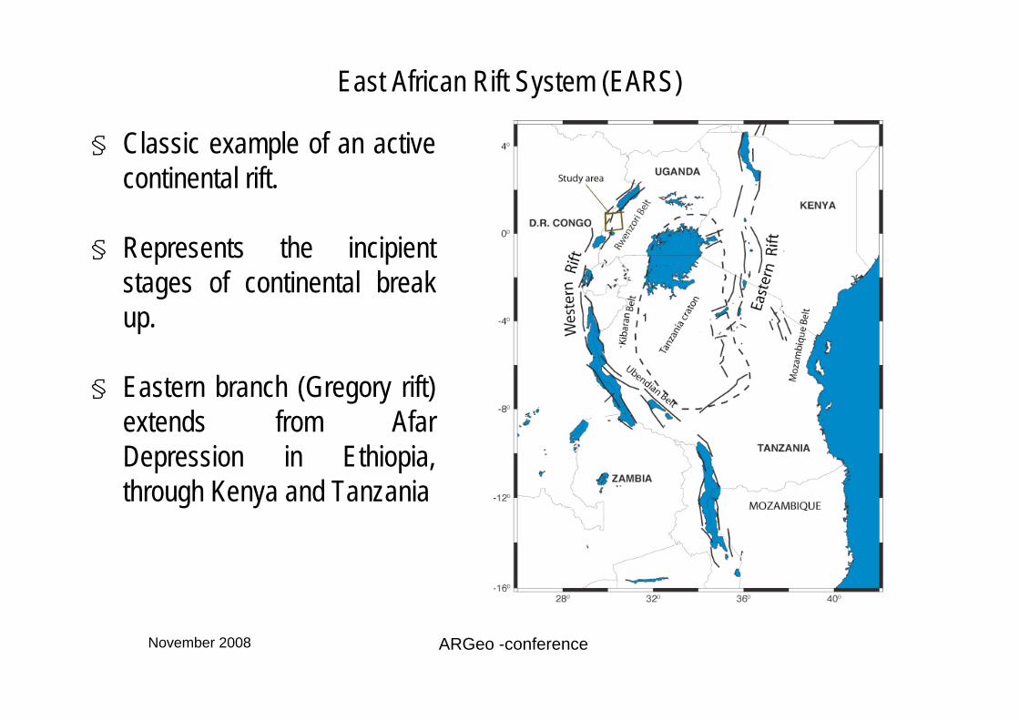
East African Rift System (EARS)
§ Classic example of an active continental rift.
§ Represents the incipient stages of continental break up.
§ Eastern branch (Gregory rift) extends from Afar Depression in Ethiopia, through Kenya and Tanzania

November 2008 ARGeo -conference
East African Rift System (EARS)
§ Western arm-----southern Sudan through western Uganda, Rwanda, Burundi and Tanzania along the boundary with the (D.R) of Congo
§ Formed within, Precambrian basement consists of the Archean Tanzania craton in the center, surrounded by a number of Proterozoic mobile belts.
November 2008 ARGeo -conference
Geology of the study area
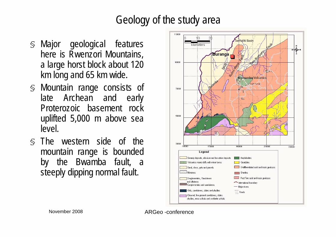
§ Major geological features here is Rwenzori Mountains, a large horst block about 120 km long and 65 km wide.
§ Mountain range consists of late Archean and early Proterozoic basement rock uplifted 5,000 m above sea level.
§ The western side of the mountain range is bounded by the Bwamba fault, a steeply dipping normal fault.

November 2008 ARGeo -conference
Geology of the study area
§ The eastern side there are the Ruimi-Wasa and Toro-Bunyoro faults.
§ The Pleistocene – Holocene Kicwamba volcanic field lies just east of the Ruimi – Wasa fault.
§ Pleistocene – Holocene sediments, locally known as Kaiso-Kisegi beds occupy the lower rift valley floor in the Semuliki basin, with a thickness of 4000-6000m

November 2008 ARGeo -conference
Data Acquisition
§ The DGSM Uganda, in collaboration (BGR), Germany, conducted a passive seismic survey around the Buranga geothermal area, first part of 2006
§ The purpose of the seismic survey was to collect micro earthquake data to aid in geothermal prospecting.
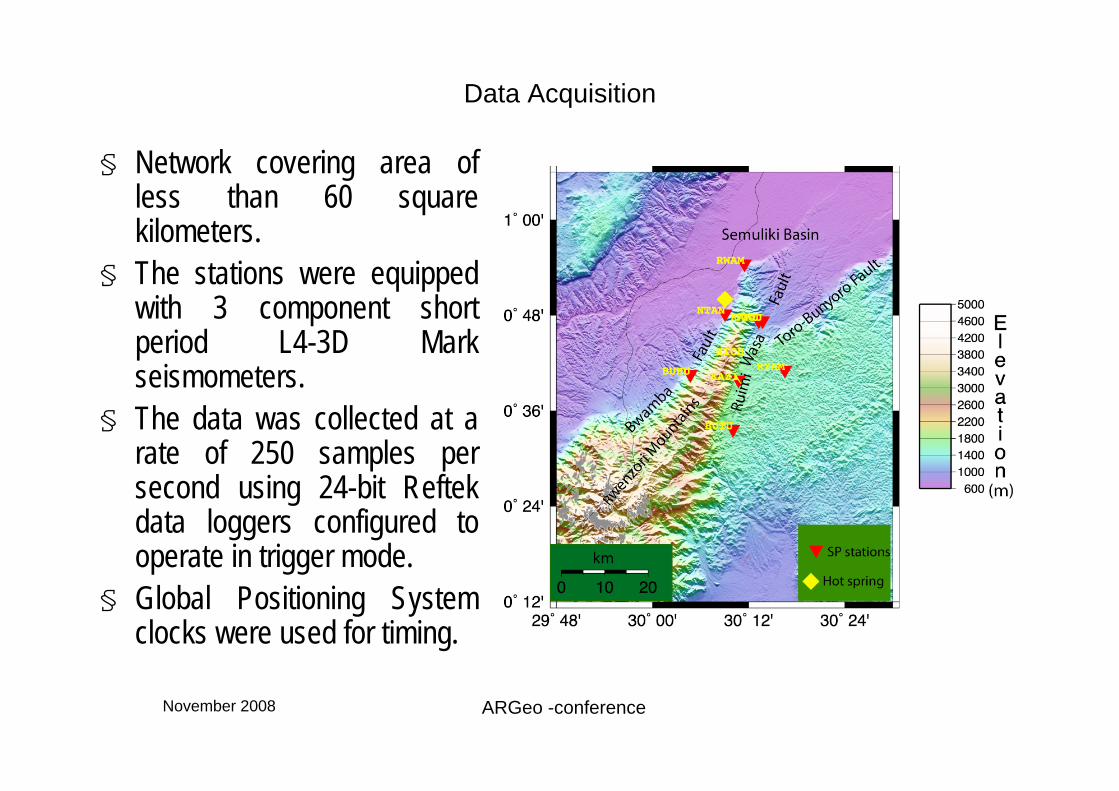
§ Location of the seismic stations in red triangles, Hot spring in yellow.
November 2008 ARGeo -conference
Data Acquisition
§ Network covering area of less than 60 square kilometers.
§ The stations were equipped with 3 component short period L4-3D Mark seismometers.
§ The data was collected at a rate of 250 samples per second using 24-bit Reftek data loggers configured to operate in trigger mode.
§ Global Positioning System clocks were used for timing.

November 2008 ARGeo -conference
Sample of data collected

November 2008 ARGeo -conference
§ Methodology§ Initial locations§ Initial hypocentral locations were obtained using with the
HYPOELLIPSE program§ Relative event location§ Relative event locations were obtained by taking the initial
hypocenter locations and using them with the double-difference algorithm (HYPODD)
§ Focal mechanisms§ P motion polarities for 69 events were used and the FOCMEC
program
November 2008 ARGeo -conference
Results-Hypoellipse
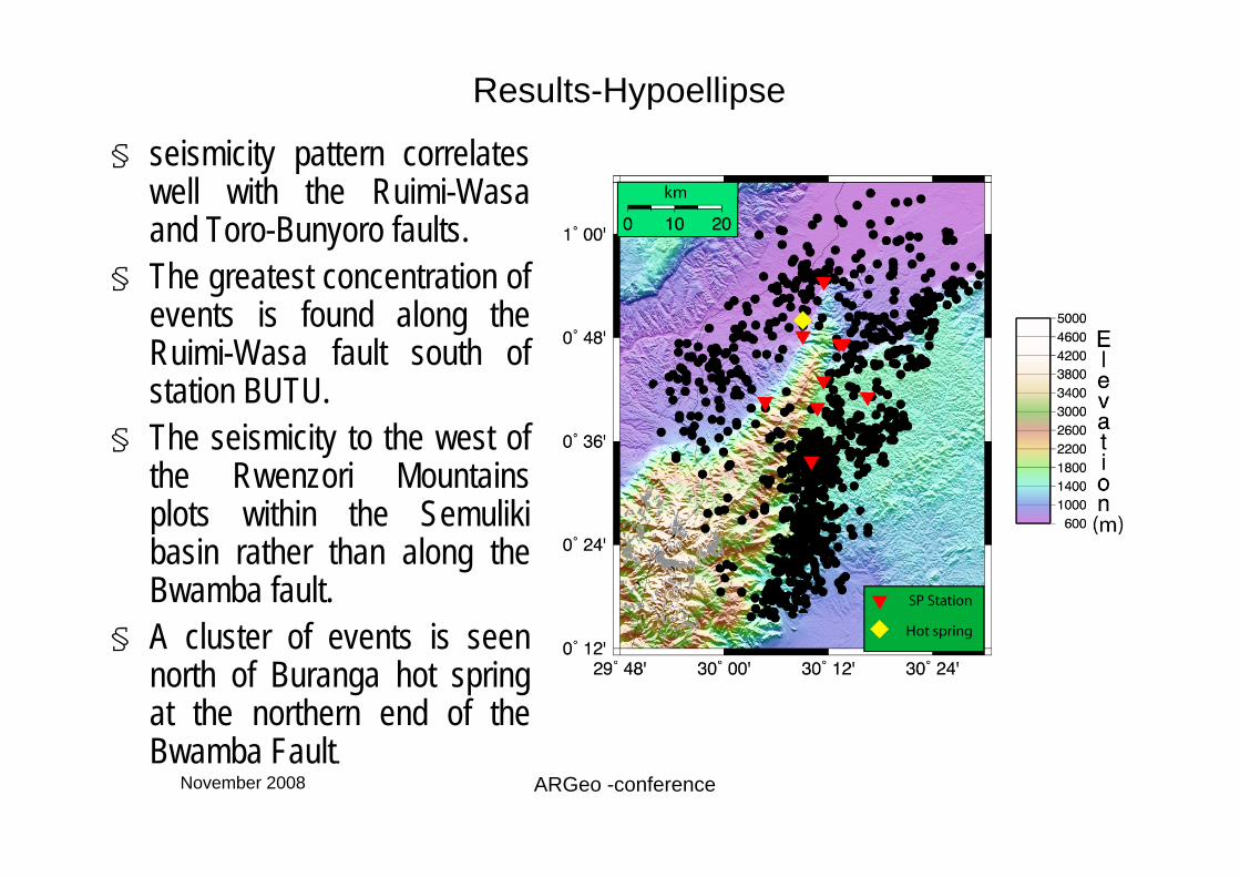
§ seismicity pattern correlates well with the Ruimi-Wasa and Toro-Bunyoro faults.
§ The greatest concentration of events is found along the Ruimi-Wasa fault south of station BUTU.
§ The seismicity to the west of the Rwenzori Mountains plots within the Semuliki basin rather than along the Bwamba fault.
§ A cluster of events is seen north of Buranga hot spring at the northern end of the Bwamba Fault.

November 2008 ARGeo -conference

November 2008 ARGeo -conference
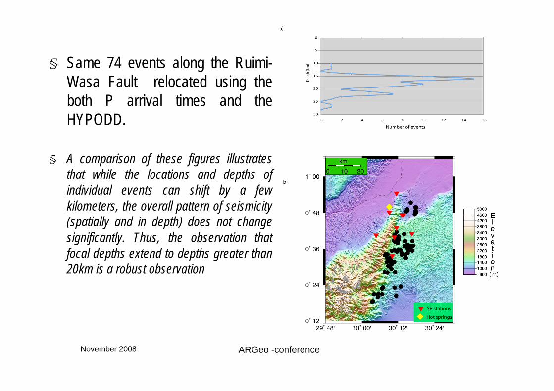
§ 74 events along the Ruimi-Wasa Fault with good quality waveforms on which S arrivals could be easily picked were relocated using the both P arrival times and the HYPOELLIPSE.

November 2008 ARGeo -conference
§ 74 events along the Ruimi-Wasa Fault with good quality waveforms on which S arrivals could be easily picked were relocated using the both P and S arrival times and the HYPOELLIPSE
November 2008 ARGeo -conference
§ Same 74 events along the Ruimi-Wasa Fault relocated using the both P arrival times and the HYPODD.
§ A comparison of these figures illustrates that while the locations and depths of individual events can shift by a few kilometers, the overall pattern of seismicity (spatially and in depth) does not change significantly. Thus, the observation that focal depths extend to depths greater than 20km is a robust observation

November 2008 ARGeo -conference
§ Epicenter locations after relocating events using HYPODD.
§ The seismicity now clusters more tightly along the Ruimi-Wasa and Toro-Bunyoro faults.
§ Most of the events in the Semuliki basin were rejected, except for a swarm of events just north of the Buranga hot springs.

November 2008 ARGeo -conference
§ Cross-sections through the southern part of the Ruimi-Wasa Fault hypocenters shift to the east with depth, suggesting an eastward dip to the fault.

November 2008 ARGeo -conference
§ Cross-sections through the northern part of the Ruimi-Wasa Fault a similar eastward shift of hypocenters is found for the northern segment of the fault.

November 2008 ARGeo -conference
§ 9 well-constrained focal mechanisms.
§ Mechanisms 1 and 2 are on the very northern end of Bwamba Fault, and mechanisms 6, 7, 8 and 9 are on the Ruimi-Wasa Fault. They all show normal faulting with extension in the general East-West direction.
§ Along the Toro-Bunyoro, mechanism 3 indicates extension in the NE-SW direction.
§ Mechanisms 4 and 5 show strike-slip motion, which might be associated with faults linking the Toro-Bunyoro and Ruimi-Wasa Faults.

November 2008 ARGeo -conference
Discussion
§ I used the depth extent of seismicity in the study area to place an upward bound on heat flow by using strength envelope calculations to estimate the depth of the brittle-ductile transition.
§ At shallow crustal depths, the deformational behavior of rock is dominated by brittle failure and depends on pore pressure.
§ At greater crustal depth, ductile deformation occurs and is dependent on rock type, strain rate and temperature.
§ In general, earthquakes are believed to occur in the brittle frictional zone, while in the ductile zone, deformation occurs by aseismic creep.

November 2008 ARGeo -conference
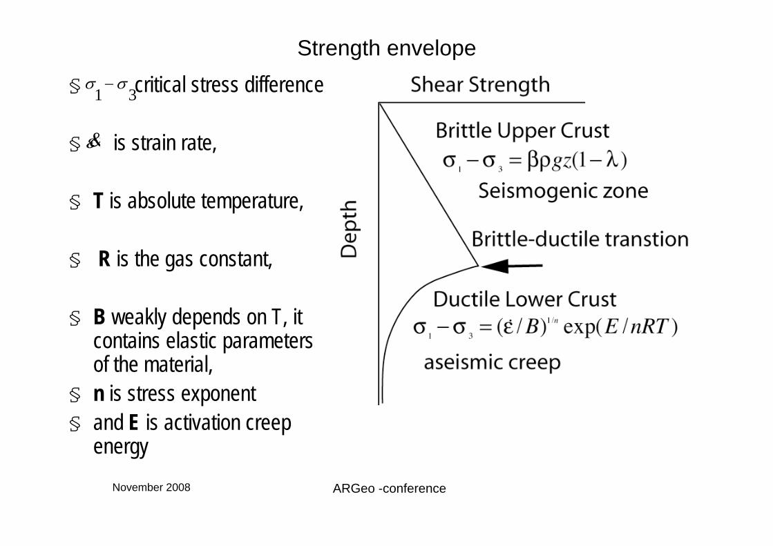
Strength envelope§ is critical stress
difference,
§ is a fault parameter,
§ is density, z is depth,
§ g is the acceleration due to gravity
§ is the ratio of the pore fluid pressure to the overburden pressure.
σ1−σ
3
β
ρ
λ
November 2008 ARGeo -conference
Strength envelope§ critical stress difference
§ is strain rate,
§ T is absolute temperature,
§ R is the gas constant,
§ B weakly depends on T, it contains elastic parameters of the material,
§ n is stress exponent§ and E is activation creep
energy
σ1−σ
3
ε&

November 2008 ARGeo -conference
§ I used a quartz diorite lithology for the crust and use the rheological parameters as follows:
§ B (MPa-ns-1) = 1.3 x 10⁻³,§ n = 2.4 § and E(kJmol-1) = 219 (Hansen and Carter (1982) and Shelton and Tullis
(1981).§ Other parameters are strain rate of 10-15s-1 is constrained by estimates of
crustal extension in the East African rift valleys (Nyblade and Langston 1995)
§ a crustal density of 2800 kgm-3, § a value of 0.75, which is appropriate for normal faulting,§ and = 0.36 (i.e, pore pressure equals to hydrostatic pressure).
βλ

November 2008 ARGeo -conference
§ Strength envelopes for a range of different geothermal gradients that place the brittle-ductile transition at depths of 16 to 22 km,
§ Roughly consistent with the depth at which seismicity in the study area decreases dramatically.

November 2008 ARGeo -conference
§ If we assume the thermal conductivity of 3 W/mK, for upper crustal rock, which is a reasonable average value for felsic rocks typically found in the upper crust
§ Using Fourier’s law of heat conductivity where is the heat flow and is the geothermal gradient, heat flow can be estimated.
Q = kdT /dz QdT /dz

November 2008 ARGeo -conference
§ A range of heat flow between about 54 and 66 mWm-2 is indicated by a depth of the brittle ductile transition that corresponds to depth at which seismicity falls off.
§ In comparison, the strength envelope for high heat flow 100 mWm-2 as found in the Kenya Rift, gives a brittle-ductile transition that is very shallow (~10km depth), and is not consistent with observed depth extent of seismicity.
November 2008 ARGeo -conference
Summary§ Is heat flow between 54 and 66 mWm-2 elevated, as one might expect for
the rift valley??
§ Nyblade and Langston (1995) report a mean heat flow of 63mWm-2 for all Proterozoic mobile belts in East Africa away from the main rift valleys.
§ The heat flow estimated here for the study areas is thus similar to heat flow from other Proterozoic mobile belts and does not appear to be anomaly high.
§ The finding that heat flow in the western rift valley around northern nose of the Rwenzori Mountains is not elevated does not preclude the possibility of the deep seated (Mantle) thermal anomaly beneath the rift.

November 2008 ARGeo -conference
Way forward
§ Deep depth geophysical prospecting methods should be given a higher consideration for further exploration.
November 2008 ARGeo -conference
Acknowledgements
§ Government of Uganda; Providing the data used in the studyStudy leave
§ Penn State University; Geophysical Computational Laboratory.