the dalles, john day & us army corps willow creek dams
TRANSCRIPT

The Dalles, John Day & Willow Creek Dams
Public Information:U.S. Army Corps of EngineersPortland DistrictP.O. Box 2946Portland, OR 97208-2946
The Dalles-John Day-Willow Creek ProjectsU.S. Army Corps of EngineersP.O. Box 564The Dalles, OR 97058-9998
US Army Corpsof Engineers Portland District
R
The Dalles Lock and Dam
John Day Lock and Dam
Willow Creek Dam
For More Information:The Dalles Lock and Dam
P.O. Box 564The Dalles, OR 97058
(541) 296-1181 https://www.nwp.usace.army.mil
http://watersafety.usace.army.mil
For Campground opportunities:http://www.reserveusa.com
http://www.wwta.org/trails/northwest_discovery/

About The CorpsThe U.S. Army Corps of Engineers is the federal government’s largest water resources development and management agency. The variety and challenge of water projects under its civil works program also serve to maintain a broad range of engineering skills critical to the Corps’ capabilities and performance during national emergencies.
The Corps’ water resource program began in 1824 when the U.S. Congress first appropriated money for improving river navigation. Since then, the Corps’ has been involved in improving the environment for fish and wildlife, navigation, reducing flood damage and ecosystem restoration. Along with these missions, the Corps generates hydropower, supplies water to cities and industry, regulates development in navigable waters and wetlands, and operates an extensive recreation program. Today, the Corps manages nearly 2,000 water resources projects nationwide.
Along with developing our nation’s water resources, the Corps is equally committed to providing a balance to conserve, protect and restore our natural environment.
The Corps of Engineers environmental operating principals may be referenced at: http://www.usace.army.mil
Federal rules and regulations concerning public use of this area are set forth in Title 36, Chapter III, of the Code of Federal Regulations and are on display in the areas of the projects most frequently used by the public. All other federal, state and local laws also apply in Corps areas.Under the Archeological Resources Act of 1979, it is illegal to excavate or remove artifacts from federal land. Violators are subject to a fine of not more than $100,000, imprisonment of not more than five years, and forfeiture of all equipment (including vehicles) used in connection with a violation.If violators are observed, report the violation immediately to the local authorities or to Corps of Engineers personnel.

THE DALLES LOCK AND DAM
The Dalles Lock and Dam is 192 miles upstream from the mouth of the Columbia River, two miles east of the city of The Dalles, Oregon. The dam extends 1.5 miles from the Oregon shore to the navigation lock on the Washington shore. Because the boundary between the two states follows the old river channel, The Dalles Dam is almost entirely in the state of Washington.
The project consists of a navigation lock, spillway, powerhouse, and fish passage facilities on both shores. Various recreational facilities are provided along Lake Celilo, the 24-mile-long impoundment behind the dam.
Although power production now greatly overshadows other purposes, an important reason for constructing The Dalles Dam was to provide safe navigation through the turbulent reaches between The Dalles and Celilo Falls in the Columbia River.
Completed in 1957, the 650 ft x 86 ft Dalles Lock enables large ships and barges to safely navigate the Columbia River. The lock has an average of 8 million tons of cargo, mostly grain and petroleum products, passing through each year.
The first 14 generators were completed in October 1960. By November 1973 an additional 8 generators were completed and are now operational.
At peak production the 22-generator powerhouse is capable of producing 2.1 million kilowatts. The half-mile-long powerhouse provides enough electricity to power 800,000 homes.
THE JOHN DAY LOCK AND DAM
John Day Lock and Dam is located at the head of Lake Celilo, 216 miles upstream from the mouth of the Columbia River. The dam crosses the river near Rufus, Oregon, about 25 miles upstream from The Dalles, just below the mouth of the John Day River. To get to John Day Dam take exit 109 from Interstate 84.
The project consists of a navigation lock, spillway, powerhouse, and fish-passage facilities on both shores. Various recreational facilities are provided along the shores of Lake Umatilla and on the John Day River.
Construction for the John Day Dam began in 1958. The first of the 16 main generators began operating in 1968; the last in 1971. Completion of John Day Dam marked the final step in harnessing the waters of the lower Columbia River. Total construction cost for the project was $511 million.
At peak production, the powerhouse is capable of producing 2.2 million kilowatts; enough to meet the electrical needs of two cities the size of Seattle. Lake Umatilla, impounded by the dam, extends upstream about 76 miles to the foot of McNary Dam.
The powerhouse is 1,975 feet long. When completed in 1971, the dam contained the second largest powerhouse in the world. Skeleton units to accommodate four additional generators have been constructed in the powerhouse, providing for an eventual capacity of 2.7 million kilowatts.

WILLOW CREEK DAM
Willow Creek Dam is located in the town of Heppner, Oregon. The Willow Creek Dam is the first major dam constructed in the U.S. using the roller compacted concrete (RCC) technique. The project was built to prevent disastrous flooding to the town of Heppner, storage and irrigation.
The dam is a concrete gravity structure, 169 feet high from the lowest point in the foundation, and 1,780 feet long at the crest. The dam has a volume of 403,000 cubic yards of concrete. Willow Creek Dam uses its own weight to withstand the forces of the impounded water and does not have to transfer these forces to the abutments.
The dam was placed closer to the town of Heppner than first planned in order to collect more water drainage from Willow Creek and Balm Fork Creek to better prevent downstream flooding. The reservoir behind the dam is a collection of 96 miles of drainage,
Construction began in September 1980 and was completed July 1983. An estimated total cost of the project was $37 million.
PROJECT DATA
THE DALLES DAM22-Generator Powerhouse
Length 2,089 ft 1636.7 m Total generating capacity 2,099,000 kwNavigation Lock
Chamber length 650 ft 198.1 m Chamber width 86 ft 26.2 m Maximum lift 90 ft 27.1 mLake Celilo
Length 23.6 mi 38 km
JOHN DAY DAM16-Generator Powerhouse
Length 1,975 ft 606 m Total generating capacity 2,480,000 kwNavigation Lock
Chamber length 650 ft 198.1 m Chamber width 86 ft 26.7 m Maximum lift 113 ft 34.4 mLake Umatilla Length 76.4 mi 123 km
WILLOW CREEK DAMDam
Top elevation 2,129 ft Length 1,780 ft Height 160 ft Width 16 ftLake
Drainage area above dam site 96 sqmi Max. controlled elevation (NGVD*) 2,113 ft Average min. elevation (NGVD*) 2,063 ft Lake surface area, acres: Max. controlled (spillway crest) 268 Average min. lake elevation 88
* NGVD - National Geodetic Vertical Datum (Mean sea level)

HYDROPOWER GENERATION
Water stored at the upstream side of the dams falls through a giant intake draft tube to strike the turbine blades. The force of the falling water rotates the turbine. The steel shaft spins the rotor in the generator and the changing magnetic field penetrates the wire coils of the stator, producing electricity.
POWER TRANSMISSION
The dams are connected by power transmission lines supplying low cost power to the people and industries of the Northwest.
The Bonneville Power Administration (BPA), federal power marketing agency for the U.S. Department of Energy, sells power produced at The Dalles, John Day and other Northwest dams. Revenues from the sale of hydropower repay the U.S. Treasury the costs of construction and operation of federal power generating facilities. Revenues also cover BPA’s cost of marketing and distributing the power to its customers.
1. Water enters powerhouse through intake scroll case2. Pressure from falling water turns turbine3. Turbine shaft turns generator’s rotor4. Electricity generated to transmission lines5. Water continues flow downstream through the draft tube
Control room at John Day Dam.
Turbine generator room at The Dalles Dam.

NAVIGATION LOCKThe Dalles Lock and Dam
A navigation lock, completed in 1957, replaced The Dalles-Celilo Canal, which was small, outmoded and inadequate and hampered barge transportation. The modern navigation lock at The Dalles Dam handles the increased size of tows with minimum delays. The slack water pool behind the dam flooded the numerous rock obstructions in the old open river channel.
John Day Lock and Dam
Lake Umatilla provides slack water for navigation, with a minimum 15-foot depth in the main channel. The navigation lock, located on the Washington shore, is 86 feet wide, 650 feet long, and provides 15 feet of water depth over the sills. With a 113-foot maximum lift, it is the highest single-lift lock in the free world.
1. With a tow going downstream, the lower lock gates (A) are closed and the filling valve (B) is opened, allowing the lock chamber to fill. The upper lock gates (C) open and allow the tow to enter the filled chamber.
LOCK OPERATION
In the Columbia River system, the level of the water behind the dam is usually about 100 feet higher than that of the water below. The navigation lock permits vessels to pass from one level to the other. Lockage is available 24 hours a day.
Locking instructions are posted on signs visible to boats approaching the upper and lower gates. A pull cord is located at each end of the lock for use by small craft operators. The lockmaster answers on an intercom. Red and green signal lights give visual directions. Radio operators should use Marine Channel 14 in contacting the lockmaster for instructions.
2. The filling valve and upper gates are closed. Water drains out through the drain valve (D) until it is level with water beyond the lower gates.
In an upstream lockage, the upstream gate is closed, the downstream gate opens and the vessel enters the locks. The downstream gate closes, the lock fills, the upstream gate opens and the vessel leaves the lock. A lockage takes about 20 minutes.
3. The lower gates open and the tow leaves the lock chamber and navigates downstream. This procedure is reversed if the tow is going upstream.

RECREATION
Recreation facilities have been developed in a number of areas, in the immediate vicinity of the dams and upstream along the river.
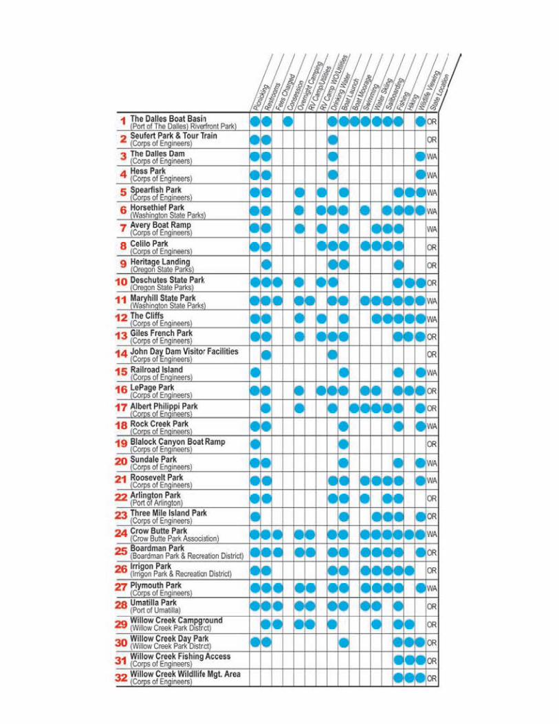
Recreation is available in a number of areas along Lake Celilo and Lake Umatilla in addition to the Seufert Visitor Center. Twenty-eight recreation areas have been developed by the Corps of Engineers, including parks at Arrlington, Boardman, Irrigon, and Umatilla in Oregon, which are operated by local entities. Horsethief and Maryhill parks in Washington are operated by Washington State Parks. Heritage Landing and Deschutes Park in Oregon are operated by Oregon State Parks. Plymouth Park in Washington and LePage Park in Oregon, Corps of Engineers campgrounds and day-use parks, have swimming, picnicking and camping facilities. Philippi Park further up the John Day River, is a Corps-operated campground accessible only by boat.
In recent years, the Columbia River has become world famous for sail boarding. Favorable water and wind combine to provide the conditions required for the sport.
Albert Philippi Park
UNDERWATER HAZARDS: Submerged stumps, logs, and rocks are present in the lakes. Be especially watchful for obstructions near the shoreline.
SMALL CRAFT WARNINGS: Dangerous waves can build up suddenly. Stay out of open waters when winds become threatening. Boaters should be aware of sudden pool fluctuations.
FIRE PREVENTION: The fire potential is generally high during the recreation season. Help prevent fires by putting out campfires. Campfires are permitted only in designated areas.
BOATING: When boating, observe all posted buoys and navigational markers. When anchoring, extreme precautions should be taken, as currents can be treacherous. Use seven to ten times as much anchor line as the depth of the river below the boat. Always wear an approved PFD (personal floatation device). For additional boating and water safety information/requirements visit the Oregon State Marine Board web site: http://www.boatoregon.com
or the Washington State boating program web site: http://www.parks.wa.gov
FISHING: Stay clear of boat channels and swimming areas. While trolling, watch the water ahead for boats, swimmers or underwater obstacles.
SWIMMING: Use the buddy system, never swim alone. Swim only in designated swimming areas away from docks and boating areas.
SAILBOARDING: Never sailboard alone. Wind and wave condition in the main channel are stronger and rougher than they appear. Sailboards are considered to be vessels and must follow the rules of the road. Barges in the channel are moving faster than they appear to be and they cannot make sudden turns or stops. Use short reaches to test your equipment and skill. Look before jibbing and jumping. Maintain proper lookout and distance. Please follow posted sail boarding information. In case of emergency, contact local authorities.
TO ENJOY A SAFE OUTING - OBSERVE THESE SAFETY TIPS
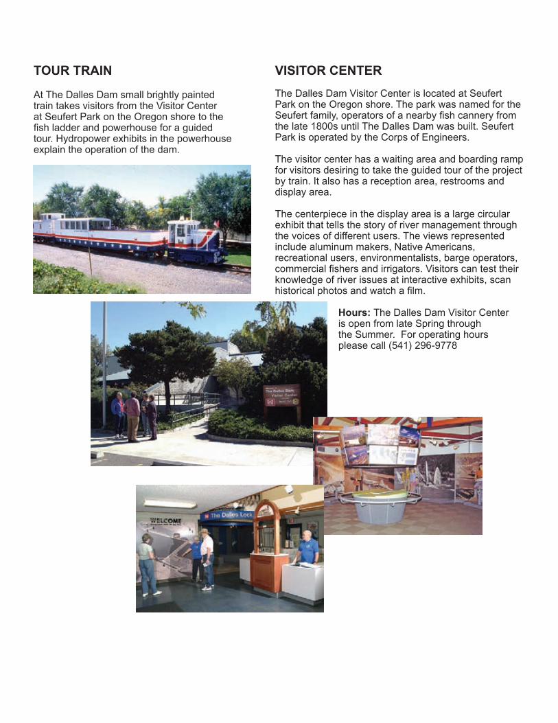
TOUR TRAIN
At The Dalles Dam small brightly painted train takes visitors from the Visitor Center at Seufert Park on the Oregon shore to the fish ladder and powerhouse for a guided tour. Hydropower exhibits in the powerhouse explain the operation of the dam.
VISITOR CENTER
The Dalles Dam Visitor Center is located at Seufert Park on the Oregon shore. The park was named for the Seufert family, operators of a nearby fish cannery from the late 1800s until The Dalles Dam was built. Seufert Park is operated by the Corps of Engineers.
The visitor center has a waiting area and boarding ramp for visitors desiring to take the guided tour of the project by train. It also has a reception area, restrooms and display area.
The centerpiece in the display area is a large circular exhibit that tells the story of river management through the voices of different users. The views represented include aluminum makers, Native Americans, recreational users, environmentalists, barge operators, commercial fishers and irrigators. Visitors can test their knowledge of river issues at interactive exhibits, scan historical photos and watch a film.
Hours: The Dalles Dam Visitor Center is open from late Spring through the Summer. For operating hours please call (541) 296-9778
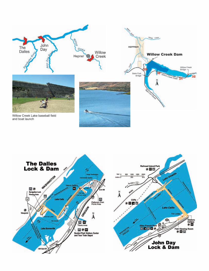
Willow Creek Lake baseball field and boat launch
FISH COUNTERS
At each fishway, a person tabulates the various species of salmon, steelhead and shad moving up the fish ladder. This important information, that helps management make decisions to sustain fish runs, has been recorded at The Dalles Dam since 1957 and John Day Dam since 1968.
Fish are counted as they pass underwater viewing windows on both sides of the project. The daily count of fish is posted at the dam and on the Internet at: http://www.nwp.usace.army.mil
In an average year, up to one million adult salmon and steelhead migrate upstream, and from 30 to 50 million fingerlings move downstream past The Dalles and John Day dams. Shad, lamprey and other species also are observed.
FISH
The federal dams on the Columbia River were designed for balanced use of the basin’s water resources. Fish ladders planned by Corps engineers, environmental specialists and fisheries experts simulate the waterfalls and pools found in natural streams.
Pools in the fish ladders are formed by cross barriers (weirs) set in a ramp leading over the dam. The weirs have openings along the bottom to allow the fish to swim easily from one stair step pool to the next. Chinook (king), coho (silver) and sockeye (blueback) salmon, steelhead trout, shad and other fish use the ladders in their upstream migration.
Fish passage facilities at each project divert ocean-bound juvenile fish around the dams. This is supplemented by millions of fingerlings being transported downstream by the Corps’ fish barging program. Raising fingerlings at hatcheries also helps to mitigate for the spawning areas lost when lakes filled behind the dams.
Spring Creek Hatchery, on the Washington shore of the Bonneville Dam pool, operated by the U.S. Fish and Wildlife Service, provides partial mitigation for loss of fall chinook caused by construction of John Day Dam. The Bonneville Fish Hatchery, operated by Oregon Department of Fish and Wildlife, provides the balance of mitigation.
FISH BYPASS SYSTEM
A juvenile fish bypass system was installed at John Day Dam to increase survival rates of downstream migrant fish. The system is designed to collect fish before they enter turbine intake areas and to transport them around the dam to reduce injury or disorientation. The system was completed in February 1997 at a cost of $23 million and was operational in time for the spring downstream fingerling migration.

FISH VIEWING
At The Dalles Dam, visitors can observe migrating fish at the east fish ladder. A closed circuit video projector provides visitors with a life-size view of the fish passing.
The best times of the year for fish viewing are:
steelhead - July through October
spring chinook - Mid-April through mid-June
summer chinook - Mid-June through mid-August
fall chinook - Mid-August through October
shad - Mid-May through July
Port of Th& OalleS RiY9front Pall<
2 Seufert Park & Tour Train Cor of E ineers
1 The Dalles Boat Basin
WA
WA
WA
WA