the chicago shoreline originally consisted of a … chicago shoreline originally consisted of a...
TRANSCRIPT
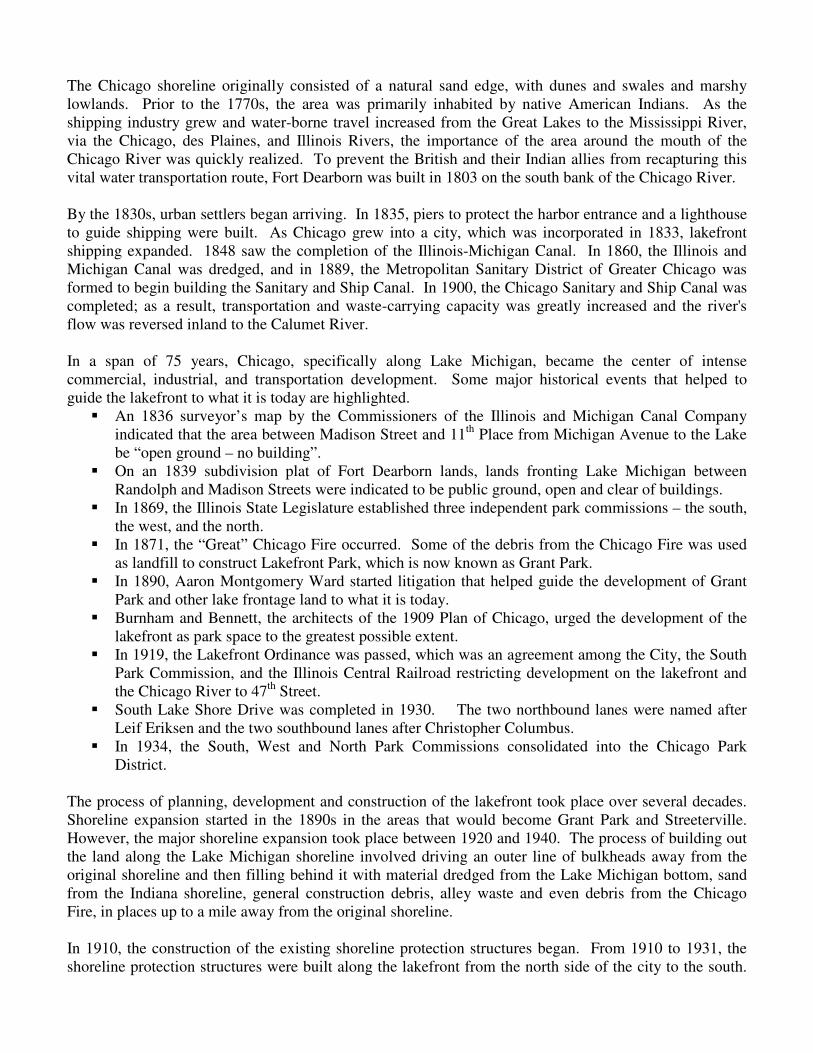
The Chicago shoreline originally consisted of a natural sand edge, with dunes and swales and marshy
lowlands. Prior to the 1770s, the area was primarily inhabited by native American Indians. As the
shipping industry grew and water-borne travel increased from the Great Lakes to the Mississippi River,
via the Chicago, des Plaines, and Illinois Rivers, the importance of the area around the mouth of the
Chicago River was quickly realized. To prevent the British and their Indian allies from recapturing this
vital water transportation route, Fort Dearborn was built in 1803 on the south bank of the Chicago River.
By the 1830s, urban settlers began arriving. In 1835, piers to protect the harbor entrance and a lighthouse
to guide shipping were built. As Chicago grew into a city, which was incorporated in 1833, lakefront
shipping expanded. 1848 saw the completion of the Illinois-Michigan Canal. In 1860, the Illinois and
Michigan Canal was dredged, and in 1889, the Metropolitan Sanitary District of Greater Chicago was
formed to begin building the Sanitary and Ship Canal. In 1900, the Chicago Sanitary and Ship Canal was
completed; as a result, transportation and waste-carrying capacity was greatly increased and the river's
flow was reversed inland to the Calumet River.
In a span of 75 years, Chicago, specifically along Lake Michigan, became the center of intense
commercial, industrial, and transportation development. Some major historical events that helped to
guide the lakefront to what it is today are highlighted.
� An 1836 surveyor’s map by the Commissioners of the Illinois and Michigan Canal Company
indicated that the area between Madison Street and 11th
Place from Michigan Avenue to the Lake
be “open ground – no building”.
� On an 1839 subdivision plat of Fort Dearborn lands, lands fronting Lake Michigan between
Randolph and Madison Streets were indicated to be public ground, open and clear of buildings.
� In 1869, the Illinois State Legislature established three independent park commissions – the south,
the west, and the north.
� In 1871, the “Great” Chicago Fire occurred. Some of the debris from the Chicago Fire was used
as landfill to construct Lakefront Park, which is now known as Grant Park.
� In 1890, Aaron Montgomery Ward started litigation that helped guide the development of Grant
Park and other lake frontage land to what it is today.
� Burnham and Bennett, the architects of the 1909 Plan of Chicago, urged the development of the
lakefront as park space to the greatest possible extent.
� In 1919, the Lakefront Ordinance was passed, which was an agreement among the City, the South
Park Commission, and the Illinois Central Railroad restricting development on the lakefront and
the Chicago River to 47th
Street.
� South Lake Shore Drive was completed in 1930. The two northbound lanes were named after
Leif Eriksen and the two southbound lanes after Christopher Columbus.
� In 1934, the South, West and North Park Commissions consolidated into the Chicago Park
District.
The process of planning, development and construction of the lakefront took place over several decades.
Shoreline expansion started in the 1890s in the areas that would become Grant Park and Streeterville.
However, the major shoreline expansion took place between 1920 and 1940. The process of building out
the land along the Lake Michigan shoreline involved driving an outer line of bulkheads away from the
original shoreline and then filling behind it with material dredged from the Lake Michigan bottom, sand
from the Indiana shoreline, general construction debris, alley waste and even debris from the Chicago
Fire, in places up to a mile away from the original shoreline.
In 1910, the construction of the existing shoreline protection structures began. From 1910 to 1931, the
shoreline protection structures were built along the lakefront from the north side of the city to the south.

The additional land created was developed to have a wide variety of uses (e.g., parkland, beaches,
harbors, lagoons, golf courses, etc.). Most of the land along the lake is open to the public. The
protection structures generally consisted of limestone blocks, wooden piles, tiebacks, and wakefield
sheeting, but in some instances were paved beaches or perched sand beaches. In many areas, the
limestone was grouted to help keep them in place. The following cross-sections show examples of some
of the types of structures that were built as erosion control and shoreline protection measures.
Example of the revetment between
Diversey Parkway and Fullerton
Parkway.
Example of the revetment between
Belmont Avenue and Diversey
Parkway.
Example of the revetment between
• Melrose Street and Belmont
Avenue; and
• Montrose Avenue Peninsula.
Example of the revetment between
• Belmont Avenue and Diversey
Parkway;
• Buena Avenue to the Belmont
Harbor; and
• Fullerton Avenue to North
Avenue.

The following photographs highlight the construction and infilling of the water to create the land along
Lake Michigan.
Example of the revetment between
• Outer perimeter of Northerly
Island;
• Burnham Park Harbor to
Pershing Road; and
• 39th
Street to 56th
Street.
Railroad sheds and rolling stock were familiar
objects along the lakefront in 1892.
Installation of the bulkhead between Randolph Street
and 12th Street, 1923. Cutting piles and sheeting.
Installation of the bulkhead between Randolph Street
and 12th Street. Shows limestone blocks to be placed.
1922 Bulkhead extending the shoreline completed.

References:
Chrzastowski, Michael J., Department of Natural Resources, Illinois State Geological Survey, Geology of the Chicago
Lakeshore: The Chicago River Mouth (poster), 1998.
Chrzastowski, Michael J., Department of Natural Resources, Illinois State Geological Survey, Geology of the Chicago
Lakeshore: Shaping the Chicago Lakeshore (poster), 1999.
City of Chicago, Richard J. Daley, Mayor, The Lakefront Plan of Chicago, December 1972.
U.S. Army Corps of Engineers, Illinois Shoreline Erosion, Interim III - Wilmette to Illinois/Indiana State Line, Storm Damage
Reduction. Final Feasibility Report and Environmental Assessment. July 1993.
1923 aerial, showing the outer bulkhead of Northerly
Island.
1925 aerial, showing filling operations.
1928 aerial, showing filling operations in what is now
Burnham Park.
1929 aerial, showing construction of Adler
planetarium, the filling operations at 12th Street Beach.
Shoreline early 2000s. From the south,
looking north.
Shoreline early 2000s. From the
northern end of the City, looking south.
Shoreline early 2000s. From Belmont
Harbor, looking south.