the chaparral environment - fs.fed.usthe chaparral environment chaparral is a plant community in...
TRANSCRIPT
I n recent years, urban development has extended intorural areas around many of our larger cities. Where the
topography is relatively flat and open, this encroachmentpresents no great difficulty, but where the cities are sur-rounded by steep, brush-covered slopes, development hasresulted in all-too-frequent loss of life and property.Although intense efforts have been made to deal with thisproblem, one pressing need is clear: greater coordination inplanning for fire control and for the prevention of flooding,landslides, and erosion.
The brushland fire-flood-erosion sequence is particu-larly well known in chaparral areas of southern California.Urban encroachment accelerates the cycle and adds thepotential for tragedy. Unless adequate measures are takenin new developments, fire protection and flood controlagencies are hard pressed to safeguard life and property.
When hazardous conditions come about through im-proper land use or lack of planning, they are extremelydifficult to correct by either private or public action.Government agencies should therefore work together toadopt comprehensive protection plans before permission isgranted for wildland development. These plans mustresolve the problem presented by new construction in eco-logically sensitive areas, so that added services for safe-guarding such developments are not paid fur by society as awhole.
Living in the urban-wildland interface creates biologicaland social problems which cannot be readily resolved.Logically, zoning ordinances should exclude developmenton steep chaparral wildlands and in areas where flooding isa common occurrence. But these are also the areas mostdesirable to potential home buyers because they offer aview or serve as secluded, wooded hideaways. Most of thepioneer homeowners who initially settled in these areaswere aware of the danger of fire and flood and were able tolive in closer harmony with natural conditions. Most mod-ern homeowners, however, are ill equipped to live in thewildlands and have come to depend on private and publicorganizations for support and safety. Today’s homeownerswant to live in natural surroundings, but often do not knowhow. To live more safely in the mountains, they mustregain the pioneering spirit of self-help, neighborhood
teamwork, and an understanding of nature’s ways. Toooften, home buyers fail to realize that fire protection agen-cies may not be able to save the “home” from fire, and thatbuilding and safety and flood control agencies may bepowerless to save them from floods and rnudshdes.
This report is intended to bring about greater under-standing of a fragile ecosystem chaparral. It describespreventive maintenance measures that should help reducethe damage from fire and flood. The information providedhere is addressed to homeowners, home buyers, develop-ers, landscape architects, land use planners, wildland man-agers, zoning agencies, city and county boards of supervi-sors, and other interested persons.
Although the report sometimes deals with them separ-ately, protection from fire and prevention of erosion gohand in hand. Fire protection that weakens slopes andcauses slides, or slope protection that increases fire hazard,can give us only a dangerous illusion of safety. From arealistic view, the price we must pay to live in the chaparralis high; it can be lowered only through wise planning andmanagement.
THE CHAPARRAL ENVIRONMENT
Chaparral is a plant community in California that hasadapted over millions of years to summer drought andfrequent fires. Similar vegetation is found in regions ofMediterranean climate throughout the world. These re-gions lie along the western edges of the continents, roughlybetween 28° and 37° latitude in the Southern Hemisphereand between 30° and 43° latitude in the Northern Hemi-sphere. Except in the Mediterranean Sea, the ocean waterin these regions is comparatively cool; cold currents flowtoward the equator, and local upwelling brings cold waterto the surface. In summer, high-pressure systems bring dryair to these regions, but in winter, rain-producing frontsmove in.
Mediterranean regions are found in the countries ofEurope, Africa, and Asia that border the Mediterranean
Sea; in southwest Australia and South Africa; and in Cen-tral Chile, Mexico, and the State of California. The climateis characterized by hot, dry summers and wet, moderatewinters. Rainfall ranges from about 10inches (250 mm) toabove 32 inches (800 mm). The mixtures of plant specieswithin these areas are determined by such factors as aspectand steepness of slope, soils, elevation, fire frequency, andlocal climate.
Chaparral Vegetation
Two distinct subformations of chaparral called “hardchaparral” and “soft chaparral” are clearly distinguished inrecent ecological literature and are commonly referred toas chaparral and coastal sage scrub communities, res-pectively (Paysen and others 1980, Westman 1982). Thisdistinction is important for both fire and slope manage-ment.
The coastal sage scrub community or “soft” chaparral israpidly becoming an “endangered” habitat because it iscommonly found in California’s coastal zone, where mosturban expansion is taking place. It is generally restricted tothe more xeric sites at lower elevations, because of orogra-phic effects, and at higher elevations because of shallowsoils (Miller 1981).The dominant species that compose thecoastal sage scrub community are of smaller stature thanthose in the chaparral community and provide a moreopen habitat that encourages more herbaceous speciesincluding the sages, California sagebrush, and deerweed. IThe chaparral community as a whole is drought-tolerant.In comparison with hard chaparral species, which tend tostart growth in winter, coastal sage species tend to startgrowth soon after the first significant autumn rains. Addi-tionally, both annual plant productivity and wildfires inthis community tend to be related to the amount of rain-fall, whereas hard chaparral species are more independentof rainfall in these respects (Minnich 1983).
Generally, plant adaptations to drought include thickleathery leaves, reduced leaf size, and summer dormancy, acondition which enables the plant to reduce its metabolicfunctions and drop leaves under prolonged drought. Twoadaptations to fire are sprouting and fire-stimulated ger-mination of seeds. Sprouting produces new shoots fromthe roots or root crown after the top has been injured byfire, browsing, pruning, or other means (Sampson 1944).Itmay begin soon after a fire if soil moisture is available tothe deep root system. After an early summer fire, sproutsmay grow more than a foot tall before the first rains comein the fall.
Both sprouting and nonsprouting plant species germi-nate prolifically after fires. The seeds of many chaparral
ICommonpublication.Mentioned,
2
names of plants and animals are used throughout thisFor scientific names, see Appendix: List of Species
species remain viable for a long time; often a thick seedcoat protects the endosperm from drying out. Fire ofteninjures this seed coat so that seeds germinate under properconditions of moisture and temperature. In the air-driedstate, many seeds can tolerate temperatures higher than302° F (150° C) for 5 minutes within the seed zone (tophalf-inch of soil layer), but tolerance to high temperaturesis sharply reduced when seed moisture content is high(Sweeney 1956). Seeds of some plant species may germi-nate readily with or without fire, whereas other specieswith a hard seed coat, such as certain Ceanothus speciesand many legumes, often require very hot fires to germi-nate. Nature has developed a set of survival mechanismsfor the varying fire and environmental conditions in thechaparral region.
Besides the sprouts and seedlings of the perennial chap-arral species, seedlings of herbaceous species are abundantin the first few seasons after fire. Seeds of many of thesespecies lie in the soil for years awaiting stimulation by firefor germination. Fire-dependent annuals and perennialsare responsible for the beautiful array of wildflowers thatcan be seen everywhere the first few seasons after a fire.They provide a natural vegetative cover that helps tempor-arily to reduce the heavy erosion that can be expected fromsteep mountain slopes once existing protective cover hasburned off. These short lived, fire-adapted species convertmineral nutrients to organic form, thus conserving nut-rients that could be lost by leaching and erosion. Somespecies, such as deerweed, are able to obtain mineralizedsoil nitrogen from symbiotic bacteria and nlay be animportant means of returning it to the soil in an availableform for other plants. Nitrogen is the plant nutrient mosteasily lost during a fire.
Many chaparral plants exude chemical inhibitors, com-monly called allelopathic agents. These volatile or water-soluble antagonistic chemicals are carried by the heat ofthe day or by water to the soil and other plants, where theymay effectively stunt growth and reduce or eliminate seedgermination (Muller 1966, Muller and others 1968, Rice1974). Allelopathy is widespread in nature and the chemi-cal agents probably accumulate in the soil from one year tothe next. Allelopathy may function as a plant defensivemechanism that assures availability of the limited moistureand nutrients to the dominant plants on the site. By remov-ing litter and burning the soil surface, fire acts to reduce theeffects of these chemical inhibitors in the soil.
Plant species diversity peaks in the first few seasons aftera fire, but is reduced when, in the years after a fire, thefire-dependent annuals and short-lived perennials fail toreproduce. In hard chaparral, shrub species such as bushpoppy and Ceanothusmay decline in vigor after 10and 20years, respectively, and provide dry, dead fuel for futurefires. Chaparral fires aid in the continued survival of thesespecies. The oldest stands of hard chaparral generally havethe lowest species diversity and tend to be even-aged. Incontrast, most mature coastal sage stands are uneven-agedand have greater species diversity because of seedling
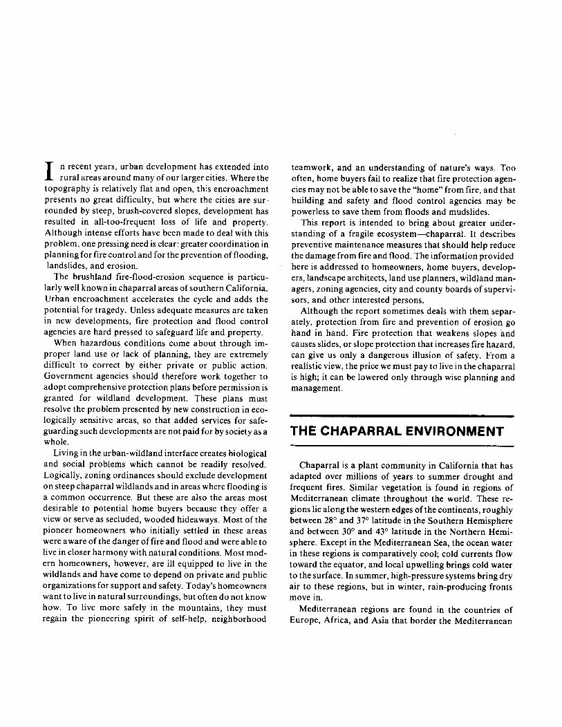
Figure l—The 1923 Berkeley Fire-considered themost devastating in California’s history+roke out inWildcat Ridge (A), reaching the city (B) before finallycoming undercontrol (C).Wind velocityon September
‘1
/\,
— Humidity (pet)----- Temperature (“F)
,/,/’-’-. \. ./
\.L/./
Fire weather
AB
T“
‘“\...-
8 12 4 8 12 4 8 12 4 8 12 4 8 12 4 8 12MT MT Ml
Saturday Sunday Monday17 was 40 mph (64.4 kph). (Source: Emanuel Fritz, Sept. 15 Sept. 16 Sept. 17University of California, Berkeley).
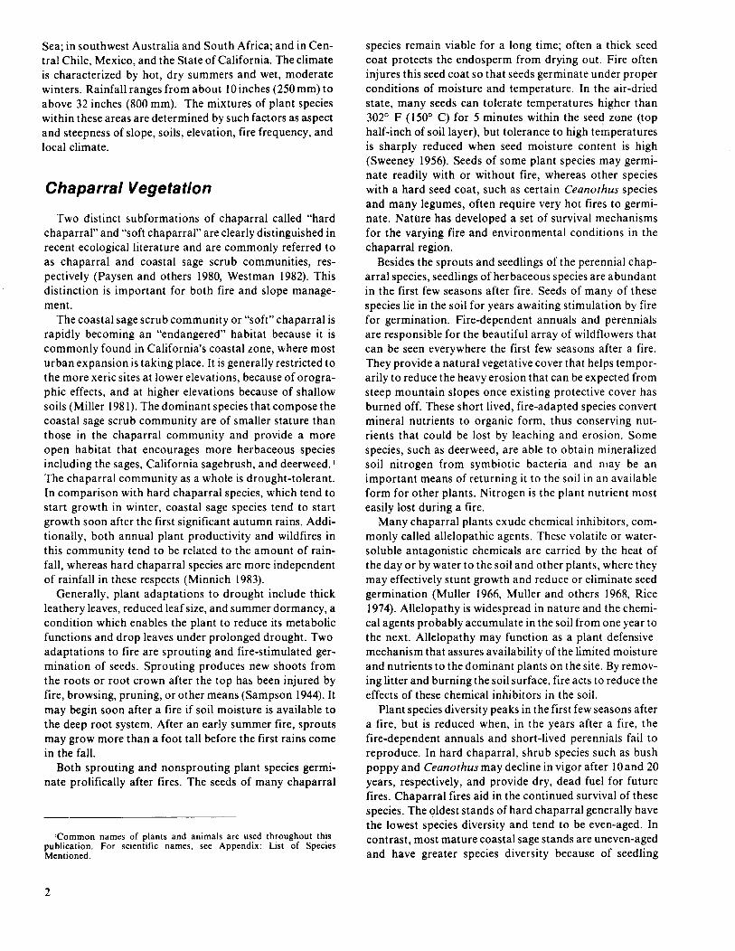
Figure 2—The Oat Fire in Los Angeles County,whichstarted on October 31, 1981 (A) and burned 15,500acres,was contained during the night (B)despite dan-gerous fire weather conditions characterized by lowrelative humidity. Young age classes (average: 11years) of woody chaparral species offered relativelyhigh resistance to fire spread.
------ Temperature (“F)— Relative humidity (pet) ~.-.,
i “\.,, _,,,/”.-.....~.-...
./”’ -,-. J/
Fire weather
12 4 8 12 4 8 12 4 8 12 4 8 12 4 8 12 4 8 12 4 8 12 4 8 1:MT Thursday ‘T Friday ‘T Saturday MT Sunday ‘“
Oct. 29 Oct. 30 Oct. 31 Nov. 1
establishment in the absence of fire and also greater herbdiversity and cover.
Fire and Chaparral
Wildfires in California can occur at almost any time ofyear but are most prevalent during the dry season. Extremefire conditions normally exist from September throughDecember or until the winter rains end the dry season.Fires are more likely to occur during strong Santa Anawinds; these winds, also known as Santana, foehn, devil, orfire winds, blow from the north to northeast out of theGreat Basin of Utah, Colorado, and surrounding northernStates. As the airis compressed and forced southwestwardto lower elevations, it becomes hot, dry, and gusty. WhenSanta Ana winds meet the local mountain winds, unpre-dictable weather patterns are often set up, making erraticfire fronts and spotting ahead of fires a commonoccurrence.
The rapid changes in temperature and humidity before,during, ~nd after- the 1923 Berkeley Fire illustrate theeffects of fire winds on local climate wig. 1).Itwas the mostdevastating fire in California history, with 624 housesburned in a single conflagration. High winds and woodshingles were the major factors in the heavy structurallosses. Within 1hour of the onset of the Santa Ana windsat 8:30 p.m., humidity had dropped from 92 to 25 percent.By midnight, temperature had increased from 63° F (17.2°C) to 82° F (27.8° C).
In southern California, humidity mayapproach 10per-cent, as it did in the 1981Oat Fire in Los Angeles County(iig.2). Most major fires in the chaparral areas of southernCalifornia occur during this extreme fire weather. UnderSanta Ana conditions, wildfires are extremely difficult tocontrol unless the fuel supply is exhausted or the windsubsides. Studies of fire problems in Los Angeles County,particularly the coastal Santa Monica Mountains, pointthis out (Radtke 1978, 1982; Weide 1968). A study offrequency of fires burning more than IOOacresin the Santa
3

Monica Mountains from 1919 to 1982 indicates that thegreater portion of wildland areas have burned at least oncein the last 60years; some have burned more than four times@g. 3).
In the interior mountain ranges of Los Angeles County,fire frequency and number of acres burned are high in thesummer months because of high summer temperatures andoccasional lightning strikes. In the coastal ranges, firefrequency is lower in the summer, and lightning strikes arealmost unknown as causes of fire. The number of acresburned is lower than in the interior ranges because theCatalina eddy, a marine breeze characterized by cool,moist air, penetrates the coastal mountains, primarily dur-ing June and July. This cool air is also responsible for theabnormal air circulation pattern of upslope instead ofdownslope winds during the evenings and into the night. Inboth the inland and coastal regions, the great toll ofacreage burned from late September through December isthe result of the Santa Ana wind, which has its highestfrequency from September to February and is almostabsent in July and August.
The pressure for urbanization of wildlands and openspace is significant in the Santa Monica Mountain range.Before intensive settlement began, the north-facing slopes(those facing the San Fernando Valley) were relatively freefrom fire, but in the last 35 years large fires have greatlyincreased here. Presently the estimated fire-start probabil-ity in coastal sage scrub is about once in 14years and in
chamise chaparral once in 16years (McBride and Jacobs1980). This large increase in fire starts is the result of thepopulation influx: almost every fire is started accidentallyor deliberately by man.
The areas of highest fire frequency are at the fire perime-ters, where fires burn together. In such a high-fire-frequency area, only the first fire burns hot because thequantity of fuel remaining for subsequent fires is reduced.The fire boundaries are determined by fire suppressionactivities, fuel types and their age classes, topography, fuelmodification attempts (firebreaks, roads, and subdivi-sions), and wind conditions. Once a fire perimeter is estab-lished, it normally defines a portion of the boundaries forfires that burn as much as 20 to 30 years later wig. 3). Thisbecomes clear when we realize that chaparral fire intensitydepends on the mixture and age of the individual chaparralspecies. The ratio of dead to live fuel is much greater in oldthan in young chaparral and varies from species to species.Past fire frequencies suggest that under natural conditionschaparral does not become highly fire-prone for about 15to 20 years, or until some of the shorter-lived chaparralcomponents die and increase the dead fuel (Philpot 1977).Coastal sage scrub, because of its shorter lived species andgreater mixture of herbaceous species, can become highlyfire-prone after 5 to 8 years.
The major flammable vegetation types found in theSanta Monica Mountains, namely chaparral, coastal sagescrub, and grassland, also have a direct bearing on fire
‘aci’cm’an=;
\o 5 10
I 1KlloMyl:Jers
ih \
II 1
0 3 6
Figure 3-Frequency of fires exceeding 100 acres (40 hectares), in theSantaMonicaMountains(VenturaCounty linetothe San DiegoFreeway),southern California, 1919to 1982.The outline on the leftshowsthe extentof the Da~on Canyon Fire, October 1982.
4

frequency and fire intensity because of their different fuelloads and ease of ignition. For example, the flashy annualgrassland fuel seldom exceeds 5 tons per acre (1 1.2 t/ha)whereas mature chaparral can exceed 30 tons per acre (67t/ha). Grassland fires may be more frequent but are alsomore easily extinguished; however, they often carry the fireinto the coastal sage scrub and chaparral. In any event, thefuels dictate the ease of fire starts and spread rates and thishas a direct bearing on fire frequency. When the grasslandswere grazed, reducing fuel loads, the highest fire frequencywas found in coastal sage. With reduction in sheep grazing,fires in annual grassland, especially along roads and rightsof way, have become the major source of fire starts. Never-theless, fire starts have been historically concentrated inthe coastal sage areas, where development has beengreatest.
The predictable direction of fire spread in the SantaMonica Mountains during Santa Ana winds is south tosouthwest. This spread pattern is primarily influenced byfire winds and secondarily by topography. Because canyonsin the eastern part of the Santa Monica Mountain rangerun in a south to south-westerly direction or parallel withthe fire winds, fire is channeled up the canyons, spreads outas it reaches the ridges, contracts again as it is funneleddownhill through the canyons, and may fan out in eitherdirection as it reaches the beaches. The western portion ofthe Santa Monica Mountains does not have this pro-nounced linearity of canyons and fire winds, however.Fires therefore are more influenced by the direction of thewinds and are more irregular in shape (Weide 1968).
PROBLEMS INWATERSHED MANAGEMENT
A watershed is generally understood to be all the landand water within the confines of a drainage area. Verti-cally, it extends from the top of the vegetation to theunderlying rock layers that confine water movement. Ahomeowner’s watershed is the area of land whose drainagedirectly affects the safety of that person’s property. Fre-quently this area includes adjacent properties over whichthe homeowner has little control. The drainage conditionsmay vary widely. Some homeowners have a well-mani-cured property adjacent to a street where all runoff ischanneled into rain gutters. Others are in a watershed thatincludes steep slopes where most runoff finds its way even-tually into intermittent stream beds. Sometimes the steepslopes are undercut by either natural stream channel ero-sion or development activities. To know how to safeguardtheir properties, homeowners shGtild understand the ero-sional processes affecting a watershed, and the changesbrought about by wildfire and their own actions.
Dry-Creep, Wet-Erosion Cycle
In chaparral, preserving the stability of the slopes is amajor problem. Most chaparral in southern Californiagrows on geologically young mountains where the steepslopes range from 25° to more than 70°. About 25 percentof the chaparral watershed exceeds the angle of repose,that is, the angle between the horizontal and the maximumslope that a particular soil or other material assumesthrough natural processes. On slopes that exceed the angleof repose, gravitational forces are likely to cause soil androcks to slide or fall downhill unless anchored by plants.The angle of repose increases with the compaction of thematerial, with the average size of fragments, with thesurface roughness and cohesion of soil particles, and, insand, with an increase in moisture content up to the satura-tion point. For loosely heaped soil particles the standardangle of repose is approximately 9° for wet clay, 11°to 20°for dry sand and mixed earth, 21° to 25° for gravel, and23° for moist clay (Van Burkalow 1945). Under naturalconditions and where soil is anchored by deep-rootedplants, the angles of repose are much steeper than thosegiven. Occurrence of landslides in chaparral is stronglyrelated to the angle of repose for different soils, oncecover, root depth, and root strength are taken intoconsideration.
On steep, harsh southern exposures, plant cover issparse, and dry creep and dry ravel (downhill soil anddebris movement during the dry season) become majorerosional forces, especially where slopes beyond the angleof repose have been undercut. During low rainfall years,this dry creep and dry ravel often exceed wet erosion ratesduring the winter months. The debris settles at the foot ofthe slopes, where it is flushed out by the rainstorms ofhigher-than-usual intensity, which occur about every 5years. Dry creep and dry ravel can also be greatly acceler-ated by animals, such as deer, rodents, and birds.
The dry-wet cycle on these slopes begins when summerdrought encourages dry creep and dry ravel. The onset ofthe first light winter rains gives the soil cohesion andgreatly reduces dry erosion. If further rains do not followbefore the soil dries out, dry creep and dry ravel againaccelerate. With heavier rains, dry erosion finally stopscompletely, so that erosion is at a minimum during the firstpart of the rainy season. As the rainy season continues,however, the soil mantle becomes saturated and rill andgully (overland) erosion accelerates. Toward the end of therainy season and until the soil surface dries out and loses itscohesiveness, erosion is again low (Anderson and others1959).
The erosion cycle is influenced by topography and vege-tation. A north-facing slope is less exposed to the sun thana south-facing slope, and is therefore more moist for thegreater part of the year. On north exposures, deeper soilsand more dense plant cover of different species have deve-loped over time, and these greatly reduce dry creep andoverland erosion. Dry ravel occurs sporadically but may
5
4
Slope (degrees)
h . ; ‘:’ ‘:s
,* 3“ 33 ‘83
;h
2:1 50 26
2
“k
1:5:1 67 34
1.5
L
1:1 100 45
1 Run
Run (horizontal)
L,kel,hood of SOIISIIPS
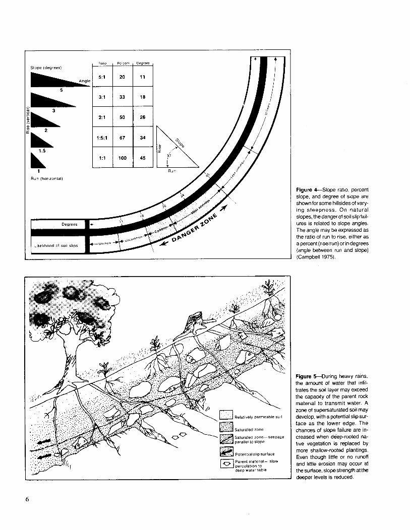
Figure 4-Slope ratio, percentslope, and degree of slope areshownfor somehillsidesof vary-ing steepness. On naturalslopes,thedangerof soilslipfail-ures is related to slope angles.The angle may be expressedasthe ratio of run to rise, either asa percent(rise/run)or indegrees(angle between run and slope)(Campbell 1975).
Figure 5-During heavy rains,the amount of water that infil-trates the soil layer may exceedthe capacity of the parent rockmaterial to transmit water. Azone of supersaturatedsoil maydevelop,with a potentialslipsur-face as the lower edge. Thechances of slope failure are in-creased when de’ep-rooted na-tive vegetation is replaced bymore shallow-rwted plantings.Even though little or no runoffand little erosion may occur atthe surface,slopestrengthat thedeeper levels is reduced.
6

be high during or immediately after a fire; plants that wereanchoring the debris on their uphill side are burned off,and gravitational forces are again influential.
Dry creep is more continuous and at times almostimperceptible, but soil slips and slumps (landslides)—themajor wet erosional processes on mature chaparral water-sheds—are readily visible. A soil slip is a miniature lands-lide caused by downslope movement of soil under wet orsaturated conditions. Slips and slumps account for almost50 percent of the total erosional processes on a watershed(Rice 1974).
Soil failures are most common on slopes that range from25° to 45° ~ig. 4). As the slopes become steeper, thethickness of the soil mantle decreases and rockslidesbecome more common. The minimum angle of soil failureis steeper for chaparral vegetation than for grasses. Slidesoccur primarily during rainfall of high intensity, after thesoil has been saturated from a single major storm or fromseveral medium- to high-intensity storms in close succes-sion. In such cases, the rate of water infiltration into thesoil mantle exceeds the rate of percolation into the underly-ing bedrock. This results in supersaturated soils @g. 5).
Slips and landslides occur more readily when the inter-face of the soil and the parent material is low in shearstrength (resistance to separation), but this is not easy topredict for a particular region. Slides may not add much tothe immediate amount of downstream sediment erodedfrom a particular watershed because the eroded materialmay accumulate at the base of the slope. The sedimenteffect of slides is magnified after a fire because even mod-erately heavy storms can create high-velocity overlandflow of water over bare hillsides, carrying away the accum-ulated sediment. Because flow velocity is further increasedin the streambeds, the water can transport greater amountsof debris.
F iC
The amount of erosion after a fire depends on the stormintensity and the time elapsed since the fire (ruble 1).Postfire erosion may be more than 50 to 100times greaterthan on a well-vegetated watershed. Understanding of thefire-flood cycle is vital to watershed management becausethe peak flows created by fire-denuded hillsides areresponsible for accelerated erosion and flood damage.
Table 1—Amouni of erosion related 10 age of chaparral and maximum24-hour precipitation
Years Erosion at maximum 24-hour precipitation of.sincefire 2 inches 5 inches 1I inches
Yd3/acre1 5 20 1804 1 12 140
17 0 1 285~+ o 0 3
Source: Kittredge 1973
— Runoff: bare ground (fire denuded)
-------- Runoff: forested (chaparral)
I i I i i I‘ Rainfall
Figure 6-Water runoff from a watershed denuded by fire reaches ahigher peak than that from a forested watershed
Peak flow is the point of maximum streamflow, the resultof precipitation that is added to the base streamflow afterimmediate losses for interception, infiltration, and soilmoisture recharge have been satisfied. On bare ground,peak flow increases drastically as the rate of rainfallincreases, and reaches its maximum about the same time asrainfall wig.6). As the rain stops, runoff is greatly reducedand is eliminated within a very short period thereafter. Asshown in the graph, runoff on a well-vegetated watershedis often not noticeable until the storm is well underway. Amuch reduced peak runoff is normally reached at the endof the storm, and the constantly diminishing flow is fed fora considerable period of time. Grassland watersheds havegreater peak flows than forested watersheds.
A well-vegetated watershed thus greatly reduces peakstreamflow by increasing the time before runoff begins,and by spreading it over a longer period of time. Thiseliminates or greatly reduces watershed damage, as fol-lows: Increasing the infiltration rate and lag time by asmuch as four times decreases the peak discharge rate (peakflow) by almost four times. On the other hand, a decreasein lag time and infiltration rate, caused by bare soils,produces a geometric increase in sediment-carrying capac-ity. Thus, as the velocity of the water (v) is doubled, itserosive power is increased 4 times (vz) and its carryingcapacity is increased 32 times (vS).This carrying capacitydictates the quantity and size of material that can be car-ried by a given amount of water and adds to its destruc-tiveness (Leopold 1980).
Of the wet erosional processes, scouring out of streamchannels after fires accounts for the greatest sedimentyield. Overland flow causing rill and gully erosion is next inimportance. The debris that clogs a stream channel bedand is scoured out has been accumulating since the last fireand was reduced by intermittent nonfire-related floodpeaks. Thus, even during nonfire years, channel scour is amajor source of sediment. Both channel scour and over-land flow increase with storm intensity, channel scour
7
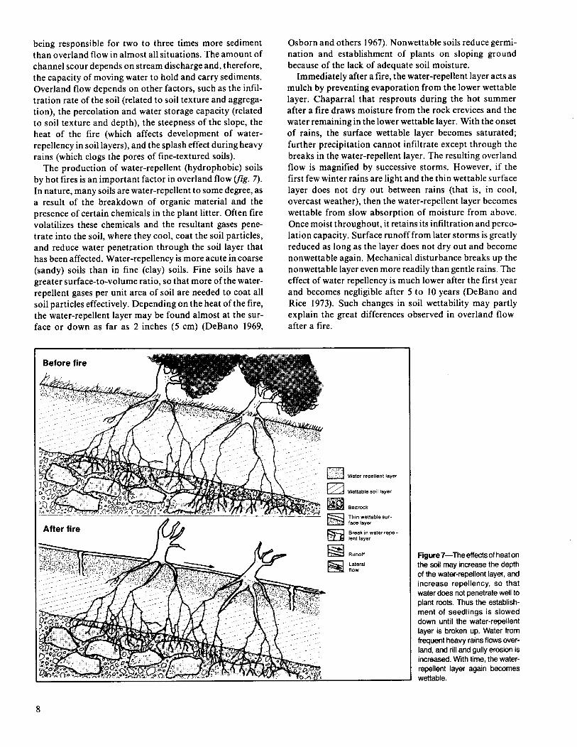
being responsible for two to three times more sedimentthan overland flow in almost all situations. The amount ofchannel scour depends on stream discharge and, therefore,the capacity of moving water to hold and carry sediments.Overland flow depends on other factors, such as the infil-tration rate of the soil (related to soil texture and aggrega-tion), the percolation and water storage capacity (relatedto soil texture and depth), the steepness of the slope, theheat of the fire (which affects development of water-repellency in soil layers), and the splash effect during heavyrains (which clogs the pores of fine-textured soils).
The production of water-repellent (hydrophobic) soilsby hot fires is an important factor in overland flow ~g. 7).In nature, many soils are water-repellent to some degree, asa result of the breakdown of organic material and thepresence of certain chemicals in the plant litter. Often firevolatilizes these chemicals and the resultant gases pene-trate into the soil, where they cool, coat the soil particles,and reduce water penetration through the soil layer thathas been affected. Water-repellency is more acute in coarse(sandy) soils than in fine (clay) soils. Fine soils have agreater surface-to-volume ratio, so that more of the water-repellent gases per unit area of soil are needed to coat allsoil particles effectively. Depending on the heat of the fire,the water-repellent layer may be found almost at the sur-
Osborn and others 1967).Nonwettable soils reduce germi-nation and establishment of plants on sloping groundbecause of the lack of adequate soil moisture.
Immediately after afire, the water-repellent layer acts asmulch by preventing evaporation from the lower wettablelayer. Chaparral that resprouts during the hot summerafter a fire draws moisture from the rock crevices and thewater remaining in the lower wettable layer. With the onsetof rains, the surface wettable layer becomes saturated;further precipitation cannot infiltrate except through thebreaks in the water-repellent layer. The resulting overlandflow is magnified by successive storms. However, if thefirst few winter rains are light and the thin wettable surfacelayer does not dry out between rains (that is, in cool,overcast weather), then the water-repellent layer becomeswettable from slow absorption of moisture from above.Once moist throughout, it retains its infiltration and perco-lation capacity. Surface runoff from later storms is greatlyreduced as long as the layer does not dry out and becomenonwettable again. Mechanical disturbance breaks up thenonwettable layer even more readily than gentle rains. Theeffect of water repellency is much lower after the first yearand becomes negligible after 5 to 10 years (DeBano andRice 1973). Such changes in soil nettability may partlyexplain the great differences observed in overland flow
face or down as far ‘as 2 inches (5 cm) (DeBano 1969, after a fire.
After fire
Waterrepellentlayer
Wettablesoil laYOr
Bedrock
Thin wettablesur-face layer
Break inwaterrepel-Ient layer
Runoff
Lateralflow
Figum7—Theeffectsof heatonthe soil may increase the depthof the water-repellent layer, andincrease repellency, so thatwater does not penetrate well toplant rmts. Thus the establish-ment of seedlings is sloweddown until the water-repellentlayer is broken up. Water fromfrequent heavy rains flows over-land, and rill and gully erosion isincreased.With time, the water-repellent layer again becomeswettable.
8
During the season after a fire, if rainfall is low and stormintensities are light, overland flow and channel scour arelessened. Dry creep, dry ravel, and occasional landslideswhich started on steep slopes during the fire may then bethe primary agents of erosion. On the other hand, dryerosion may be greatly reduced if the fire occurs imme-diately before the rainy period or between rainy periods.
Increases in landslides during the rainy period followinga fire could be caused by well-spaced storms that permeatethe nonwettable layer and completely recharge the water-holding capacity of the soil. Once the soil moisture isrecharged, a high-intensity storm could quickly supersatu-rate the soil, thereby accelerating wet creep, startingslumps and slides, and greatly increasing overland flow.Under these conditions, postfire rainy season slumps andslides have a tendency to occur more frequently on a southslope than a north slope. On south slopes, a sparse prefirevegetative cover, coupled with thin soils and a smaller rootnetwork, provides less soil-binding and water-holdingcapacity.
Postfire slips and slumps during the first few years aftera fire may be greatly reduced on nonwettable soils if highintensity storms follow each other in close order, therebyreducing rainfall penetration through the nonwettablelayer. The soil below the nonwettable layer would remaindry, eliminating landslides, but the greatly increased over-land flow would result in highly visible rill and gully ero-sion and would increase channel scour.
Erosion Factors
Erosion is the product of six factors: soils, climate,vegetation, animal activity, topography, and human activ-ity. The climate, the degree of slope of the land, and the soilphysical characteristics cannot be directly controlled toreduce soil erosion, but can be modified through soilsengineering, whose principal aim is to change slope charac-teristics so that the amount and velocity of runoff islessened.
SoilsSoil is developed through physical and chemical weather-
ing of a thin surface layer of rock and mineral fragments(soil parent material). Soil texture, structure, depth, andfertility determine what kind of plant life a soil can supportand ‘what its infiltration rate, percolation rate, and waterholding and water storage capacities will be. Soil textureand structure determine the erosiveness of soils. Texture isthe proportion of mineral particles of various sizes in thesoil; structure is the degree of aggregation of theseparticles.
In order of decreasing particle size, soil texture classesare sand, silt, and clay. Sand particles are visible to thenaked eye; individual silt and clay particles are visible onlyunder the microscope. Sandy soils are referred to as coarsetextured, loamy soils as medium textured, and clay soils asfine textured. Generally, soils composed of coarser parti-
cles drain water more rapidly than soils composed predom-inantly of finer particles. Sandy soils allow fast waterinfiltration and percolation, but little storage; clay soilsallow slow infiltration and percolation and greater storage.Sand, silt, and clay are easily eroded if the particles are notbound into stable aggregates. Organic materials and col-loidal clays are primary cementing agents. Soils high inclay content and organic material are among the leasterodible and most fertile soils. Sandy soils low in clay andorganic material tend to have high erosion rates.
Good soil structure contains much airspace, whichallows ready water infiltration into the soil, water percola-tion through the soil, and higher water storage capacity.Soils that have blocky or prismatic aggregates or thatcontain a high fraction of gravel (rock fragments largerthan 2 mm) have higher infiltration rates than soils that areplaty, such as most clay soils, or granular, such as someloamy soils.
Although geological relationships are too complex toanalyze here, review of some geologic terms and principlesshould clarify the direct implication of geology in slopemanagement. The type of rock and parent material presentare good indicators of the weathering of rocks, the soil-forming processes, and erosion. The rock hardness, thesize of the crystals, and the degree of crystal bonding andcementation are all important factors. For example, manygranitic rocks erode rapidly because of weak crystal cohe-sion and large crystal size. This makes our granitic soilshighly erodible. Rhyolite rocks weather more slowly, pro-ducing finer crystals, and soils derived from these rocks aretherefore less erodible. Basalt rocks have even finer crys-tals that weather very slowly and soils derived from theserocks are less erodible still.
Generally, metamorphic rocks (rocks that were alteredin form under extreme heat and pressure) are harder thanigneous rocks (rocks formed by cooling and solidificationof molten lava) and sedimentary rocks (rocks which werebroken down by weathering and deposited by water, wind,and gravity and then consolidated by heat or pressure orcemented by silica, lime, or iron solutions).
ClimateThe major climatic factors in erosion are precipitation,
temperature, and wind. Precipitation, viewed as the inter-play of amount, intensity, and duration, rather than asaverage rainfall, is the greatest erosional factor. The firstrainfall after a dry period saturates a bare soil surface,causing little erosion. After that, raindrops hit the soil-water surface, causing breakdown of the soil aggregates.Splashing causes muddy water, in which the smaller soilparticles are held in suspension. When this muddy waterenters the soil, the pores become clogged; infiltration slowsdown and may almost stop. Amount and velocity of runoffare increased, causing surface erosion, rills, and finallygullies. If the runoff water is concentrated long enough ona particular portion of a slope, the soil becomes saturatedand mud flows result.
9
Temperature and wind have some erosional effects.High temperatures have an indirect effect in creating aharsh environment for plants, so that revegetation is slowand there is little soil binding. Wind erosion at the surfaceis most critical on fine-grained dry soils devoid of vegeta-tion. When large areas become exposed, as on recentlytilled fields or sandy deserts, or in dry, overgrazed regions,wind erosion may become the dominant process.
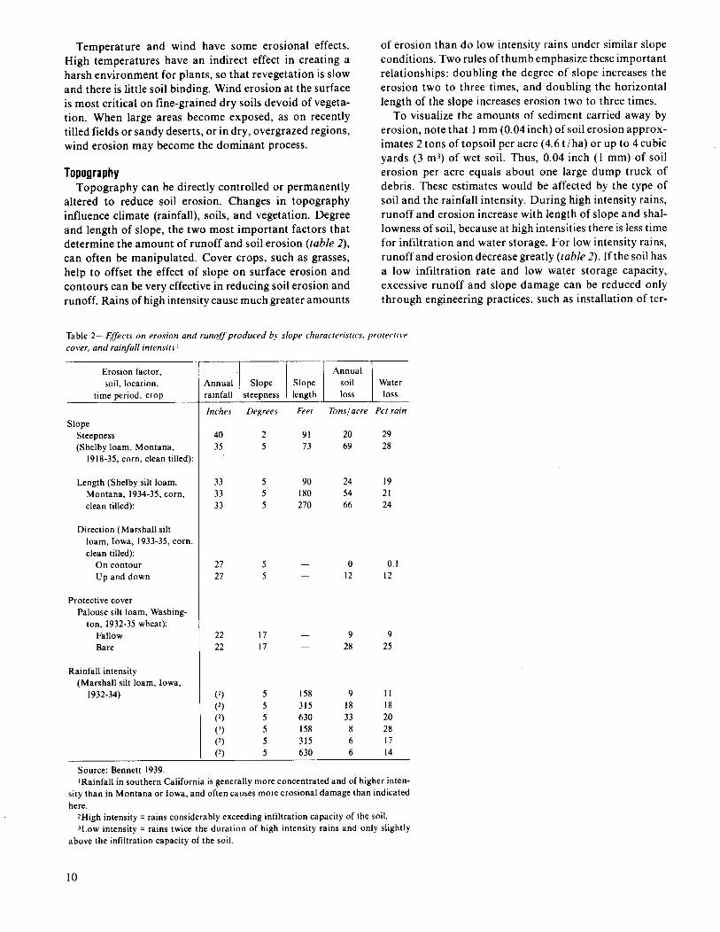
TopographyTopography can be directly controlled or permanently
altered to reduce soil erosion. Changes in topographyinfluence climate (rainfall), soils, and vegetation. Degreeand length of slope, the two most important factors thatdetermine the amount of runoff and soil erosion (ruble2),can often be manipulated. Cover crops, such as grasses,help to offset the effect of slope on surface erosion andcontours can be very effective in reducing soil erosion andrunoff. Rains of high intensity cause much greater amounts
of erosion than do low intensity rains under similar slopeconditions. Two rules of thumb emphasize these importantrelationships: doubling the degree of slope increases theerosion two to three times, and doubling the horizontallength of the slope increases erosion two to three times.
To visualize the amounts of sediment carried away byerosion, note that 1mm (0.04 inch) of soil erosion approx-imates 2 tons of topsoil per acre (4.6 t /ha) or up to 4 cubicyards (3 mj) of wet soil. Thus, 0.04 inch (1 mm) of soilerosion per acre equals about one large dump truck ofdebris. These estimates would be affected by the type ofsoil and the rainfall intensity. During high intensity rains,runoff and erosion increase with length of slope and shal-lowness of soil, because at high intensities there is less timefor infiltration and water storage. For low intensity rains,runoff and erosion decrease greatly (lab/e2). If the soil hasa low infiltration rate and low water storage capacity,excessive runoff and slope damage can be reduced onlythrough engineering practices, such as installation of ter-
Table 2—Effecis on erosion and runoffproducedb.vslopecharacteristics.protectivecover, and rainfall intensit.)l
Erosion factor,soil. location,
time Deriod. croKI
SlopeSteepness(Shelby loam, Montana,
1918-35,corn, clean tilled):
Length (Shelby silt loam,Montana, 1934-35,corn,clean tilled):
Direction (Marshall siltloam, Iowa, 1933-35,corn,clean tilled):
On contourUp and down
Protective coverPalouse silt loam, Washing-
ton, 1932-35wheat):FallowBare
Rainfall intensity(Marshall silt loam, Iowa,
1932-34)
Source: Bennett 1939
Annual\nnual Slope Slope soil Waterrainfall steepness length loss loss
Inches Degrees Feet Tons/acre Pet rain
4035
333333
2727
2222
(2)(2)(2)(3)(3)(’)
2 91 20 295 73 69 28
5 90 24 195 180 54 215 270 66 24
55
1717
012
928
0.112
925
5 158 9 115 315 18 185 630 33 205 158 8 285 315 6 175 630 6 14
IRainfall in southern California is generally more concentrated and of higher inten-sity than in Montana or Iowa, and often causes more erosional damage than indicatedhere.
‘High intensity ❑ rains considerably exceeding infiltration capacity of the soil.JLOWintensity = rains twice the duration of high intensity rains and only slightly
above the infiltration capacity of the soil.
10