the centre for aids research the geography of hiv/aids: looking beyond the maps mike clark and emma...
Post on 19-Dec-2015
214 views
TRANSCRIPT
The Centre for AIDS Research
The Geography of HIV/AIDS:Looking beyond the maps
Mike Clark and Emma Treby
University ofBournemouth
University ofSouthampton

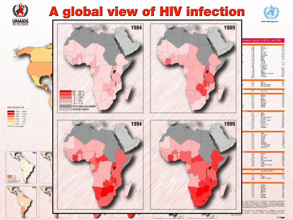
Information, suffocation or application?

The geography of HIV/AIDS: looking beyond the maps
Looking beyond the maps
Geography as a driver of understanding versus Geography as a tool for intervention (behavioural or non-behavioural)Geography as distributions of attributes (choropleth maps!) versus geography as synthesis and spatialityThe geography behind the maps:
Information, action, behaviourInformation and communication (governance)Information and management

The geography of HIV/AIDS: looking beyond the maps
Looking beyond the maps
A typology of HIV/AIDS mappingGeography and governance: a role for GIS?Issues of cautionParticipation, adaptivity and AIDS response

The geography of HIV/AIDS: looking beyond the maps
A typology of HIV/AIDS mapping
HIV, AIDS and responseA working typology of mapping
Policy-influencing (informing and attitudinal)Strategic (targets and monitoring)Operational (support and supervision)Community participation

1. Policy-influencing & attitudinal

The geography of HIV/AIDS: looking beyond the maps
Simplistic policy-influence concepts
“If you do that, this is what will happen to you”
“OK, in that case I won’t”

The geography of HIV/AIDS: looking beyond the maps
Adding realism to map influence
(after The Theory of Reasoned Action: Ajzen & Fishbein, 1975)
The geography of HIV/AIDS: looking beyond the maps
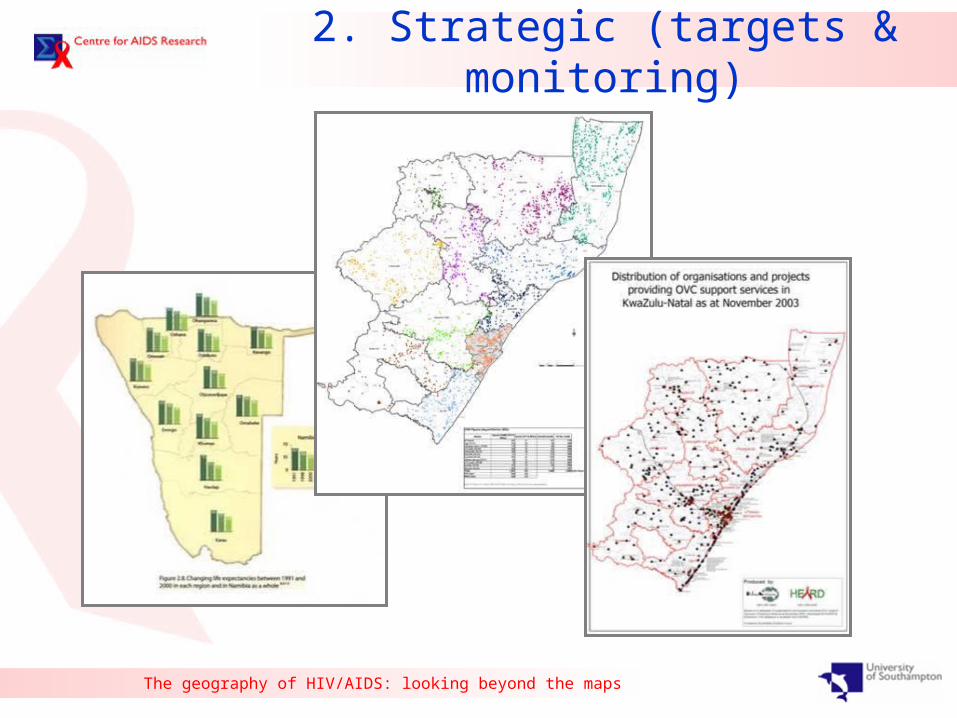
2. Strategic (targets & monitoring)

The geography of HIV/AIDS: looking beyond the maps
3. Operational (support & supervision)
Waterfall
Molweni
Msunduzi
Ngcolosi
Fredville
MpumalangaPeaceville
Hally Stott
Ntshongweni
Hlengisizwe
Qadi
Injabula
Zwelibomvu
Wyebank
Legend^ No clinic/mobile entered(15)
#* Bhekisisa Mobile Point_HS M1&2(3)
#* Botha's Hill Mobile Point_HS M1&2(1)
Fredville Clinic(9)
#* Gigaba Mobile Point_HS M1&2(6)
Halley Stott(2)
#* Halley Stott Mobiles 1&2(3)
Hlengisizwe Clinic(7)
") Injabulo Clinic_attached to Edendale Hospital(1)
#* Khayelihle Mobile Point_HS M1&2(4)
#* Mathebethu Mobile Point_HS M1&2(1)
#* Mgoqozi Mobile Point_HS M1&2(2)
#* Mhlabunzima Mobile Point_HS M1&2(12)
XWMobile(?) & Waterfall Clinic(1)
XWMobile(?) & Wyebank Clinic(2)
Molweni Clinic(16)
#* Molweni Clinic & Umgababa Mobile(1)
XWMpumalanga & Hlengisizwe(8)
XWMpumalanga & Peaceville(10)
Mpumalanga Clinic(14)
Msunduzi Clinic(23)
Ngcolosi Clinic(15)
Ntshongweni Clinic(9)
Peaceville Clinic(1)
") Qadi Building_KwaMashu Polyclinic(7)
#* Siyathuthuka Point_HS M1&2(1)
#* Smangenduku Point_HS M1&2(2)
#* Vulindlela Store Mobile Point_HS M1&2(2)
XWVulingqondo Pre-School(2)
kj Waterfall clinic(1)
kj Wyebank Clinic(7)
") Zwelibomvu Building_Prince Mshiyeni Polyclinic(3)Local Council
G Other Clinics in Outer West
G TVT related Clinics
Buffer of 5km around Msunduzi ClinicInner West CHW (106)South CHW (85 with 20 mistakes)Planning Units
Community Health Workers homesteads captured for the Outer West .Illustrating the clinics or mobiles their respective communities visit.Although most CHW seem to be within 5km of the clinictheir community uses, it does not confirm their communities fall within this radius.
Mapping – The Valley Trust

The geography of HIV/AIDS: looking beyond the maps
4. Community participation
P Johnstone & J Ranken (1994)

The geography of HIV/AIDS: looking beyond the maps
A typology of HIV/AIDS mapping
A working typology of mapping
Policy-influencing (informing and
attitudinal)
Strategic (targets and monitoring)
Operational (support and supervision)
Community participation
Focus on synthesis, aggregation &
association
Focus on location and sampling
ACCURACY
PRECISION HOW DOES GIS RELATE TO ORGANISATIONS?

The geography of HIV/AIDS: looking beyond the maps
A model of regional governance

The geography of HIV/AIDS: looking beyond the maps
A model of regional governance
A role for GIS?

The geography of HIV/AIDS: looking beyond the maps
A role for information
The geography of HIV/AIDS: looking beyond the maps
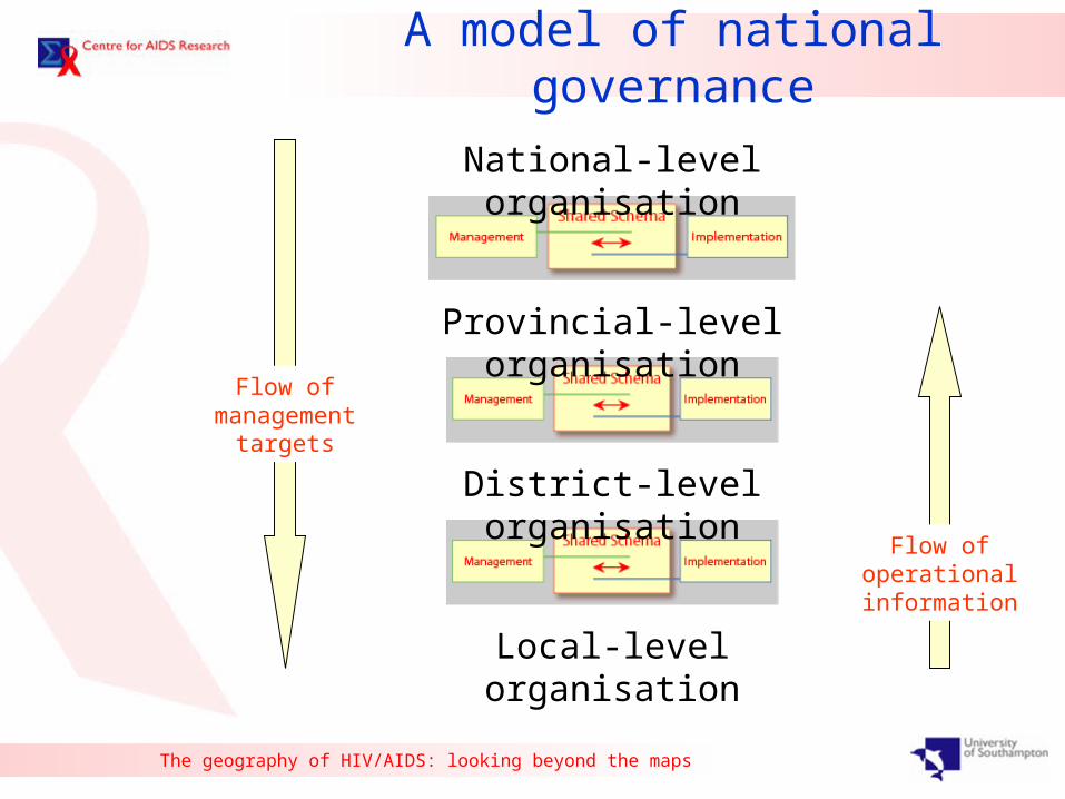
A model of national governance
National-level organisation
District-level organisation
Provincial-level organisation
Local-level organisation
Flow of management targets
Flow of operational information

The geography of HIV/AIDS: looking beyond the maps
A model of national governance
National-level organisation
District-level organisation
Provincial-level organisation
Local-level organisation
Flow of management syntheses / maps / models
Flow of operational information
?

The geography of HIV/AIDS: looking beyond the maps
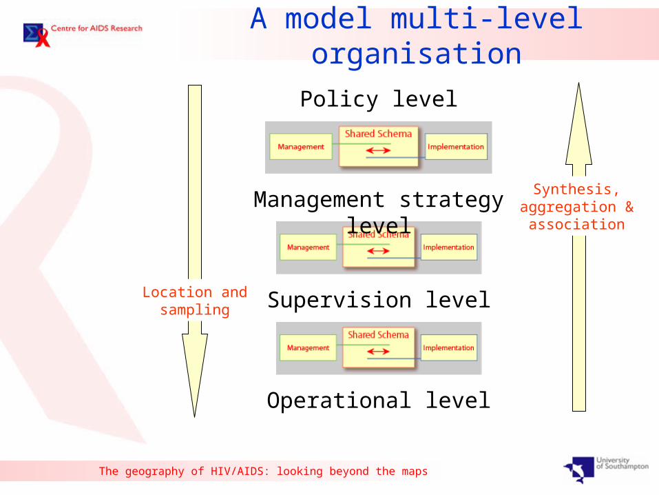
A model multi-level organisation
Policy level
Supervision level
Management strategy level
Operational level
Flow of management maps / models
Flow of operational information
GIS
Policy informing
Operational feedback
The geography of HIV/AIDS: looking beyond the maps
A model multi-level organisation
Synthesis, aggregation &
association
Location and sampling
Policy level
Supervision level
Management strategy level
Operational level
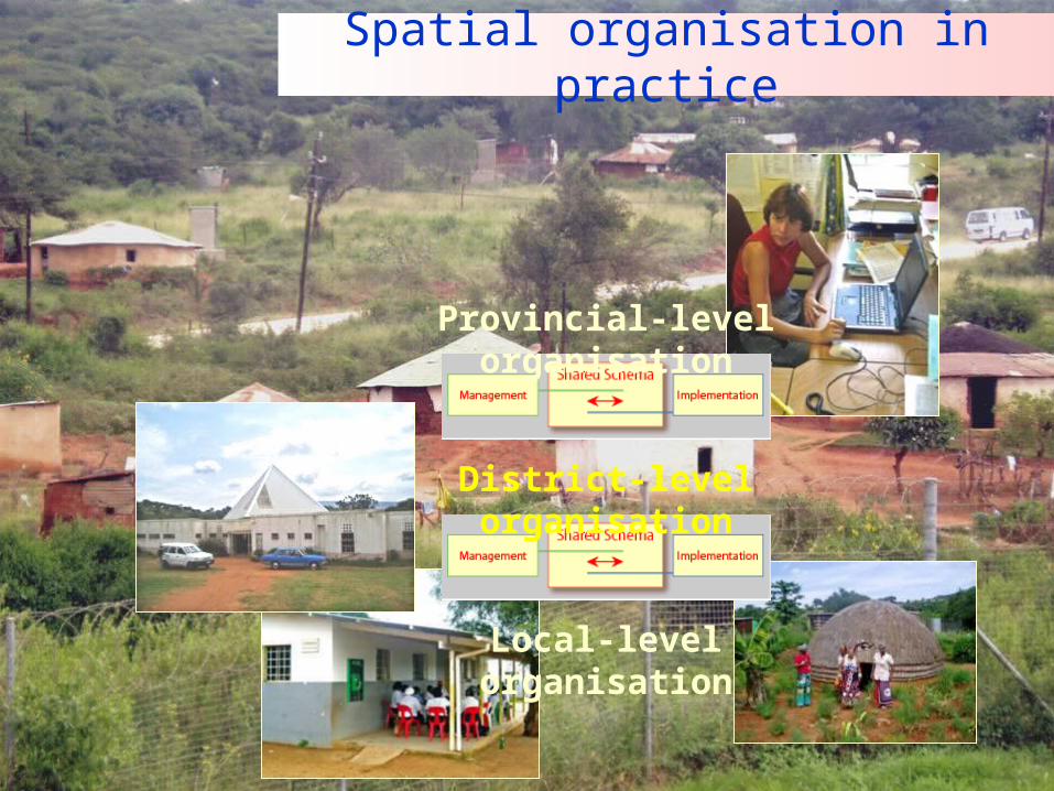
Spatial organisation in practice
Provincial-level organisation
Local-level organisation
District-level organisation

The geography of HIV/AIDS: looking beyond the maps
Applying the model: CHW

The geography of HIV/AIDS: looking beyond the maps
CHW information structure

The geography of HIV/AIDS: looking beyond the maps
A spatial structure for CHWs

The geography of HIV/AIDS: looking beyond the maps
KwaZulu Natal example
GF
GF
GF
_̂
_̂
_̂
_̂
_̂
_̂
_̂ _̂
_̂_̂
_̂
_̂
_̂
_̂
_̂ _̂
_̂
_̂_̂
_̂
_̂_̂
_̂_̂
_̂
_̂
_̂
_̂
_̂
_̂
_̂
_̂
_̂
_̂
_̂_̂
_̂
_̂
_̂
_̂
_̂
_̂
_̂
_̂
_̂
_̂
_̂̂_
_̂_̂
GeorgeDale
Mpumalanga West
Mpumalanga East
Hammarsdale-Sterkspruit
Mophela
Sankontshe
Mapping – The Valley Trust

The geography of HIV/AIDS: looking beyond the maps
The multi-facilitator model

The geography of HIV/AIDS: looking beyond the maps
The multi-clinic model
Applicable to mobile clinics or health posts
The geography of HIV/AIDS: looking beyond the maps
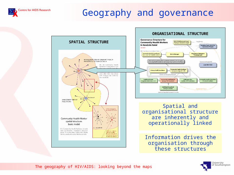
Geography and governance
ORGANISATIONAL STRUCTURE
SPATIAL STRUCTURE
Spatial and organisational structure
are inherently and operationally linked
Information drives the organisation through these
structures

The geography of HIV/AIDS: looking beyond the maps
Mapping, culture & élitism
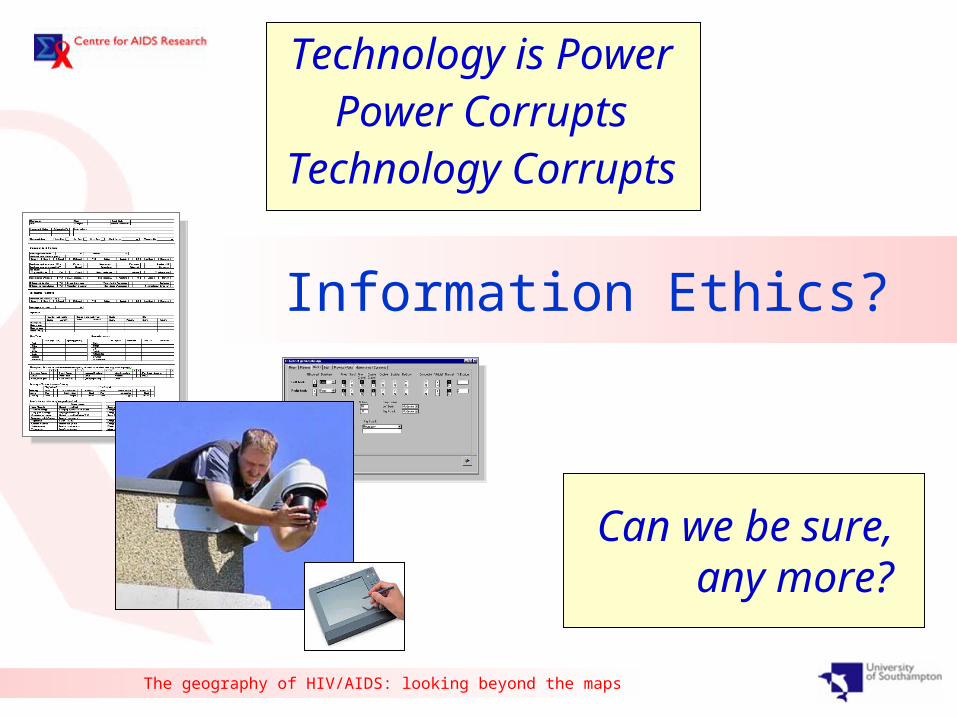
The geography of HIV/AIDS: looking beyond the maps
Technology is PowerPower Corrupts
Technology Corrupts
Can we be sure, any
more?
Information Ethics?

The geography of HIV/AIDS: looking beyond the maps
Maps of models of partial
representations of subjective indicators
of “our” world
Can we be sure, any
more?

The geography of HIV/AIDS: looking beyond the maps
ElitismExclusion
EfficiencyEngagementEmpowering
Equity
The intellectual/moral contradiction

The geography of HIV/AIDS: looking beyond the maps
ElitismExclusion
EngagementEmpowering
Equity
The intellectual/moral challenge

Maps, participation & adaptivity

The geography of HIV/AIDS: looking beyond the maps
BASELINEStatus & prediction
TARGETSWhere do we want to get
MEASURESNeeded to achieve target
MODELS/PROCEDURESPrediction/scenario/review
INDICATORSFor monitoring target and performance of measures
RISK ASSESSMENTWhy might target be
missed
= Goal setting
= Objective setting
Adaptive manageme
nt
= GIS

The geography of HIV/AIDS: looking beyond the maps
BASELINE
GOALS
RISK ASSESSMENT
MONITOR INDICATORS
MODELS/PROCEDURES
OBJECTIVES
DECISION SUPPORT
TOOLS
STAKEHOLDER PARTICIPATION
TOOLS
EN
AB
LIN
G
TEC
HN
OLO
GIE
S

The geography of HIV/AIDS: looking beyond the maps
DECISION TREE ANALYSIS
RULE-BASED / MULTICRITERIA
STATISTICAL / GEOSTATISTICAL
MATHEMATICAL MODELLING
FUZZY MODELLING
BAYESIAN MODELLING
VISUALISATION
SCENARIOS
Options Appraisal
NETW
OR
KIN
G
EN
AB
LEM
EN
T
SO
LUT
WEB
EN
AB
LEM
EN
T
SO
LUTIO
NS
IMPLE
MEN
TA
TIO
N
PR
OC
ED
UR
ES
BASELINE
GOALS
RISK ASSESSMENT
MONITOR INDICATORS
MODELS/PROCEDURES
OBJECTIVES
Policy GIS
Strategic GIS
Operational GIS

The geography of HIV/AIDS: looking beyond the maps
DECISION TREE ANALYSIS
RULE-BASED / MULTICRITERIA
STATISTICAL / GEOSTATISTICAL
MATHEMATICAL MODELLING
FUZZY MODELLING
BAYESIAN MODELLING
VISUALISATION
SCENARIOS
Options Appraisal
NETW
OR
KIN
G E
NA
BLE
MEN
T S
OLU
T
WEB
EN
AB
LEM
EN
T S
OLU
TIO
NS
ION
SIM
PLE
ME
NTA
TIO
N O
RO
CED
UR
ES
BASELINE
GOALS
RISK ASSESSMENT
MONITOR INDICATORS
MODELS/PROCEDURES
OBJECTIVES
Waterfall
Molweni
Msunduzi
Ngcolosi
Fredville
MpumalangaPeaceville
Hally Stott
Ntshongweni
Hlengisizwe
Qadi
Injabula
Zwelibomvu
Wyebank
Legend^ No clinic/mobile entered(15)
#* Bhekisisa Mobile Point_HS M1&2(3)
#* Botha's Hill Mobile Point_HS M1&2(1)
Fredville Clinic(9)
#* Gigaba Mobile Point_HS M1&2(6)
Halley Stott(2)
#* Halley Stott Mobiles 1&2(3)
Hlengisizwe Clinic(7)
") Injabulo Clinic_attached to Edendale Hospital(1)
#* Khayelihle Mobile Point_HS M1&2(4)
#* Mathebethu Mobile Point_HS M1&2(1)
#* Mgoqozi Mobile Point_HS M1&2(2)
#* Mhlabunzima Mobile Point_HS M1&2(12)
XWMobile(?) & Waterfall Clinic(1)
XWMobile(?) & Wyebank Clinic(2)
Molweni Clinic(16)
#* Molweni Clinic & Umgababa Mobile(1)
XWMpumalanga & Hlengisizwe(8)
XWMpumalanga & Peaceville(10)
Mpumalanga Clinic(14)
Msunduzi Clinic(23)
Ngcolosi Clinic(15)
Ntshongweni Clinic(9)
Peaceville Clinic(1)
") Qadi Building_KwaMashu Polyclinic(7)
#* Siyathuthuka Point_HS M1&2(1)
#* Smangenduku Point_HS M1&2(2)
#* Vulindlela Store Mobile Point_HS M1&2(2)
XWVulingqondo Pre-School(2)
kj Waterfall clinic(1)
kj Wyebank Clinic(7)
") Zwelibomvu Building_Prince Mshiyeni Polyclinic(3)Local Council
G Other Clinics in Outer West
G TVT related Clinics
Buffer of 5km around Msunduzi ClinicInner West CHW (106)South CHW (85 with 20 mistakes)Planning Units
Community Health Workers homesteads captured for the Outer West .Illustrating the clinics or mobiles their respective communities visit.Although most CHW seem to be within 5km of the clinictheir community uses, it does not confirm their communities fall within this radius.
Strategic GIS
Policy GIS
Operational GIS

The geography of HIV/AIDS: looking beyond the maps
VISUALISATION
SCENARIOS
Options Appraisal
Waterfall
Molweni
Msunduzi
Ngcolosi
Fredville
MpumalangaPeaceville
Hally Stott
Ntshongweni
Hlengisizwe
Qadi
Injabula
Zwelibomvu
Wyebank
Legend^ No clinic/mobile entered(15)
#* Bhekisisa Mobile Point_HS M1&2(3)
#* Botha's Hill Mobile Point_HS M1&2(1)
Fredville Clinic(9)
#* Gigaba Mobile Point_HS M1&2(6)
Halley Stott(2)
#* Halley Stott Mobiles 1&2(3)
Hlengisizwe Clinic(7)
") Injabulo Clinic_attached to Edendale Hospital(1)
#* Khayelihle Mobile Point_HS M1&2(4)
#* Mathebethu Mobile Point_HS M1&2(1)
#* Mgoqozi Mobile Point_HS M1&2(2)
#* Mhlabunzima Mobile Point_HS M1&2(12)
XWMobile(?) & Waterfall Clinic(1)
XWMobile(?) & Wyebank Clinic(2)
Molweni Clinic(16)
#* Molweni Clinic & Umgababa Mobile(1)
XWMpumalanga & Hlengisizwe(8)
XWMpumalanga & Peaceville(10)
Mpumalanga Clinic(14)
Msunduzi Clinic(23)
Ngcolosi Clinic(15)
Ntshongweni Clinic(9)
Peaceville Clinic(1)
") Qadi Building_KwaMashu Polyclinic(7)
#* Siyathuthuka Point_HS M1&2(1)
#* Smangenduku Point_HS M1&2(2)
#* Vulindlela Store Mobile Point_HS M1&2(2)
XWVulingqondo Pre-School(2)
kj Waterfall clinic(1)
kj Wyebank Clinic(7)
") Zwelibomvu Building_Prince Mshiyeni Polyclinic(3)Local Council
G Other Clinics in Outer West
G TVT related Clinics
Buffer of 5km around Msunduzi ClinicInner West CHW (106)South CHW (85 with 20 mistakes)Planning Units
Community Health Workers homesteads captured for the Outer West .Illustrating the clinics or mobiles their respective communities visit.Although most CHW seem to be within 5km of the clinictheir community uses, it does not confirm their communities fall within this radius.
Strategic GIS
Policy GIS
Operational GIS

The geography of HIV/AIDS: looking beyond the maps
Strategic GIS
Policy GIS
Operational GIS
The Centre for AIDS Research
The geography of HIV/AIDS: looking beyond the maps