the canadian polar data ecosystem - arctic observing · the canadian polar data ecosystem polar...
TRANSCRIPT

The Canadian Polar Data Ecosystem
Final Report
Prepared for:
Polar Knowledge Canada
Prepared by:
Polar View Canada Limited
March 2019
Draft, Not for Distribution

The Future of the Canadian Polar Data Ecosystem
Polar Knowledge Canada Final Report Rev. 1.0 March 2019
ii
Contents 1. Introduction ............................................................................................................... 1
1.1 Background ............................................................................................................. 1
1.2 Objective ................................................................................................................. 1
1.3 Methodology ........................................................................................................... 2
1.4 Report Structure ..................................................................................................... 3
2. User Needs for Data about the Polar Regions .............................................................. 4
3. Data Providers, Platforms and Facilitators in the Polar Data Ecosystem ..................... 18
3.1 Global Scale Initiatives with a Polar Component .................................................. 18
3.2 Pan Arctic Initiatives ............................................................................................. 20
3.3 National Polar Initiatives ....................................................................................... 23
3.4 University Polar Initiatives .................................................................................... 24
3.5 Initiatives Focused on Local and Indigenous Knowledge ..................................... 25
3.6 Not-for-Profit Initiatives........................................................................................ 25
4. Polar Data Infrastructure Implementation Issues ...................................................... 27
4.1 Data Preservation and Stewardship ..................................................................... 27
4.2 Data Discovery ...................................................................................................... 27
4.3 Open Data ............................................................................................................. 27
4.4 Data Access and Use Issues .................................................................................. 28
4.5 Polar Data Platforms ............................................................................................. 30
4.6 Cloud Computing .................................................................................................. 31
5. Canadian Polar Data Community .............................................................................. 33
5.1 Past Efforts ............................................................................................................ 33
5.2 Collaboration, Coordination And Governance ..................................................... 35
5.3 Interoperability ..................................................................................................... 36
5.4 Engagement of Data Providers and End Users ..................................................... 36
5.5 Policy and Funding for Sustaining Data Management ......................................... 37
6. Recommend Activities .............................................................................................. 39
Draft, Not for Distribution

The Canadian Polar Data Ecosystem
Polar Knowledge Canada Final Report Rev. 1.0 March 2019
iii
6.1 Polar Data Community Governance ..................................................................... 39
6.2 Internal and External Collaboration ...................................................................... 40
6.3 Polar Data Community Resources ........................................................................ 40
6.4 Polar Data Discovery and Access .......................................................................... 41
6.5 Polar Data Systems Interoperability ..................................................................... 42
6.6 Indigenous Knowledge and Perspectives ............................................................. 42
6.7 Other Polar Data Issues ........................................................................................ 43
A. References ............................................................................................................... 45
A.1 References (Except Chapter 5) ............................................................................. 45
A.2 References for Chapter 5 ...................................................................................... 47
B. Literature Review of User Needs ............................................................................... 50
B.1 Indigenous Community Users ............................................................................... 50
B.2 Other Users ........................................................................................................... 55
C. Data Coordinators, Providers and Platforms in the Arctic .......................................... 70
C.1 Global Scale Initiatives with an Arctic Component ............................................... 70
C.2 International Arctic Initiatives .............................................................................. 73
C.3 National Arctic Initiatives ...................................................................................... 78
C.4 Universities ........................................................................................................... 86
C.5 Initiatives focused on Indigenous and Community Based Monitoring ................ 90
C.6 Not-for-Profit Initiatives........................................................................................ 92
D. Selected Polar Data Portals and Initiatives ................................................................ 95
List of Tables Table 1: Examples of Polar Scientific Activities that Drive Information Requirements ................................. 4
Table 2: Examples of Polar Operational Activities that Drive Information Requirements ............................. 6
Table 3: User Needs Assessment Components ......................................................................................... 10
Table 4: Global programs and projects with an arctic component .............................................................. 19
Table 5: Selected Arctic Data Initiatives ..................................................................................................... 22
Draft, Not for Distribution

The Canadian Polar Data Ecosystem
Polar Knowledge Canada Final Report Rev. 1.0 March 2019
iv
Table 6: Selected National Polar Data Initiatives ........................................................................................ 23
Table 7: Limited Selection of Canadian Arctic Data Initiatives ................................................................... 24
Table 8: Polar Data Governance Participants ............................................................................................. 36
Table 9: Possible Data Management Funding Sources ............................................................................. 38
Table 10: Data Required to Meet Aboriginal Community Land and Resource Management Needs. ........ 52
Table 11: Land and Marine Data Needs in Order of Priority. ...................................................................... 56
Table 12: Arctic Science User Communities and Activities. ....................................................................... 57
Table 13: Operations User Communities and Activities. ............................................................................ 57
Table 14: Information Requirements in the Polar Regions. ........................................................................ 58
Table 15: Arctic Information Requirements. ................................................................................................ 59
Table 16: Polar Science Priority Areas and Potential Polar TEP Contributions. ........................................ 61
Draft, Not for Distribution

The Canadian Polar Data Ecosystem
Polar Knowledge Canada Final Report Rev. 1.0 March 2019
v
List of Acronyms ABDS Arctic Biodiversity Data Service
ACAP Arctic Contaminants Action Program
ADS Arctic Data Archive System
AINA Arctic Institute of North America (University of Calgary)
AIS Automatic Identification System
AMAP Arctic Monitoring and Assessment Programme
AOOS Alaska Ocean Observing System
CaaS Community as a Service
CAFF Conservation of Arctic Flora and Fauna
CBM Community-Based Monitoring
CEOS Centre of Earth Observation Sciences (University of Manitoba)
CGDI Canadian Geospatial Data Infrastructure
CI Cyberinfrastructure
CSV Comma-Separated Value
CSW Catalogue Service for the Web
DaaS Data as a Service
DEMs Digital Elevation Models
DGGS Discrete Global Grid System
DSM Digital Surface Model
DWG Data Working Group
EBSA Ecological or Biological Sensitive Areas
EGNOS European Geostationary Navigation Overlay Service
ELOKA Exchange for Local Observations and Knowledge of the Arctic
EO Earth Observation
EPSG European Petroleum Survey Group
ERDAS Earth Resources Data Analysis System
ESA European Space Agency
ESRI Environmental Systems Research Institute
EU European Union
FTP File Transfer Protocol
GCMD Global Change Master Directory
GCRC Geomatics and Cartographic Research Centre (Carleton University)
GCW Global Cryosphere Watch
GEO Group on Earth Observation
Draft, Not for Distribution

The Canadian Polar Data Ecosystem
Polar Knowledge Canada Final Report Rev. 1.0 March 2019
vi
GEOSS Global Earth Observation System of Systems
GEOTIFF Geostationary Earth Orbit Tagged Image File Format
GGD Global Geocryological Data
GML Geography Markup Language
GNSS Global Navigation Satellite Systems
HPC High-Performance Computing
HTC High-Throughput Computing
IBES Institute at Brown for Environment and Society
ICC Inuit Circumpolar Council
IHO International Hydrographic Organization
IK Indigenous Knowledge
IMO International Maritime Organization
InaaS Information as a Service
IRs Implementing Rules
ITK Inuit Tapiriit Kanatami
LTK Local Traditional Knowledge
NetCDF Network Common Data Format
NFS Network File System
NGO Non-Governmental Organization
NMAs National Mapping Agencies
NORDECO Nordic Agency for Development and Ecology
NPO Non-Profit Organization
NSDI National Spatial Data Infrastructure
NSIDC National Snow and Ice Data Centre
OGC Open Geospatial Consortium
OSCAR Observing System Capability Analysis and Review
PacMARS Pacific Marine Arctic Regional Synthesis
PAME Protection of the Arctic Marine Environment
PDC Polar Data Catalogue
PGC Polar Geospatial Center
REST Representational State Transfer
RFI Request for Information
SaaS Software as a Service
SBAS Satellite-Based Augmentation System
SDI Spatial Data Infrastructure
SLD System Landscape Directory
Draft, Not for Distribution

The Canadian Polar Data Ecosystem
Polar Knowledge Canada Final Report Rev. 1.0 March 2019
vii
SOS Sensory Observation System
TEP Thematic Exploitation Platform
UCD User Centered Design
UI User Interface
UNA User Needs Assessment
VGI Volunteered Geographic Information
WAAS Wide Area Augmentation System
WCS Web Coverage Service
WFS Web Feature Service
WMF Windows Metafile
WMO World Meteorological Organization
WMS Web Map Service
WMTS Web Map Tile Service
WPS World Programming System
Draft, Not for Distribution

The Canadian Polar Data Ecosystem
Polar Knowledge Canada Final Report Rev. 1.0 March 2019
1
1. Introduction
1.1 Background There is currently intense interest in the polar regions, with an associated requirement for integrated information to support the research and operations of a growing range of user communities, including science, industry, government, and northern communities. The use of polar data by these groups contributes to environmental protection, heritage preservation, economic development, safety of life and property, and national sovereignty.
The polar data community, in Canada and internationally, consists of a wide variety of data producers, managers, and users. They contribute to, maintain, and use data in a broad and complex polar data ‘ecosystem’. Within this ecosystem, a number of organizations promote and facilitate national and international collaboration towards improving data access and interoperability.
There is already a considerable wealth of polar data available through portals that vary substantially in function, scope, capability, and content. However, the polar data community is aware that there are many opportunities for improvement in how polar data are stored, managed, discovered, and delivered to users across these platforms, and they are working to improve the situation.
The development of polar data platforms is occurring within a context of rapid growth in the provision of polar data and change in user expectations about access to and use of such data. The data available on the state of the planet is growing in precision, volume, velocity, variety, and value, increasing the complexity of scenarios for data exploitation, as well as the resources required by the communities using the data.
There is now a need to better understand the state of Canada’s polar data ecosystem, its role in the international system, and how it can be structured and developed to better meet the needs of the polar data community.
1.2 Objective Polar Knowledge Canada (POLAR) has a mandate to advance Canada’s knowledge of the Arctic and strengthen Canadian leadership in polar science and technology. Investments by POLAR in
Draft, Not for Distribution

The Canadian Polar Data Ecosystem
Polar Knowledge Canada Final Report Rev. 1.0 March 2019
2
understanding and engaging in the development of the emerging polar data and information1 system in Canada and internationally will directly contribute to realizing their mission.
The opportunity and challenge for POLAR is to establish how they will contribute to, and benefit from, the national and international polar data system. Possible contributions include development of policy and norms (e.g. open data), understanding the concept of ethically open data - particularly with respect to documented Indigenous knowledge, establishment of distributed systems (such as search), implementation of service infrastructures, creation of models for interoperability (incl. standards, technologies, architecture, governance etc.), meaningful engagement with Indigenous organizations and communities, efficient and effective adoption of new technologies, and development of innovative business models. The needs clearly go beyond technical activities and require that the socio-technical nature of the system be recognized. In order to support decision making as to the most appropriate roles and activities for POLAR within the ecosystem, this study has:
1. Assessed the current state of the polar data ecosystem in Canada and around the world at different levels of scale and granularity,
2. Determined the needs of the polar community for data and the extent to which those needs are being met by the current ecosystem, and
3. Assessed possible roles for the Federal government in polar data activities both nationally and internationally.
1.3 Methodology The study was based primarily on a literature review of material concerning polar data management and user needs for polar data. The references consulted are listed in Appendix A. This included literature on international organizations that are concerned with data in the polar regions. Key documents dealing with Indigenous Community needs were reviewed. The review also included an assessment of findings and conclusions from key international studies and meetings related to polar data. As well, a web review of existing polar data portals and initiatives was undertaken. This work resulted in a comprehensive summary of existing user needs studies and a database of over 150 polar data portals/initiatives currently in existence.
1 Data is commonly conceptualized as part of the data-information-knowledge-wisdom hierarchy with data being recorded facts and information being a processed, synthetic that can directly inform or address questions. Defining data and information can be complex and nuanced. For simplicity here the term information is generally used to encompass data, information and documented forms of knowledge.
Draft, Not for Distribution

The Canadian Polar Data Ecosystem
Polar Knowledge Canada Final Report Rev. 1.0 March 2019
3
1.4 Report Structure The report is divided into six chapters. Following this introduction, Chapter 2 documents user needs for data in the polar regions identified from the review of previous relevant user needs assessments and available literature. The third chapter describes the key data providers, platforms and facilitators that currently exist to serve the needs of polar data users. Chapter 4 highlights some of the important data access and use issues that impact how well polar data user needs can be met. The fifth chapter discusses the Canadian polar data community’s work to address polar data issues. Chapter 6 provides a summary of activities recommended by the Canadian polar data community. Appendices are provided that include references consulted, more detailed information concerning user needs, more detailed information concerning data provision, and profiles of polar data initiatives and portals.
Draft, Not for Distribution
The Canadian Polar Data Ecosystem
Polar Knowledge Canada Final Report Rev. 1.0 March 2019
4
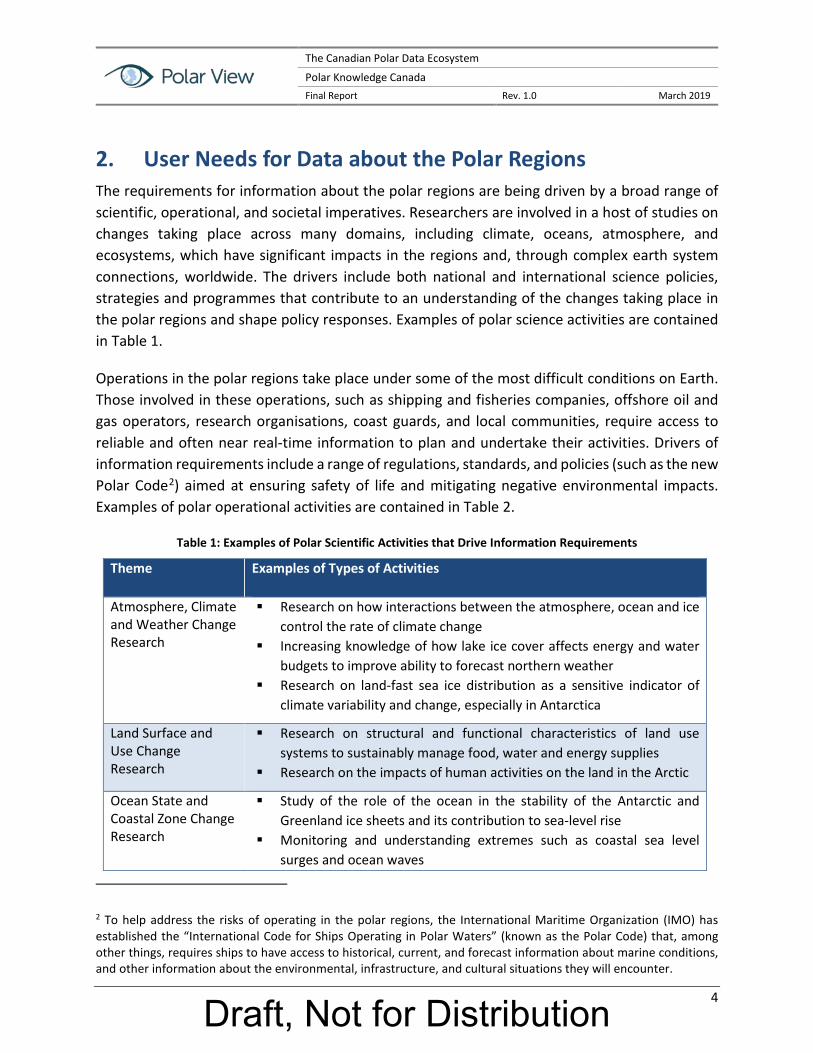
2. User Needs for Data about the Polar Regions The requirements for information about the polar regions are being driven by a broad range of scientific, operational, and societal imperatives. Researchers are involved in a host of studies on changes taking place across many domains, including climate, oceans, atmosphere, and ecosystems, which have significant impacts in the regions and, through complex earth system connections, worldwide. The drivers include both national and international science policies, strategies and programmes that contribute to an understanding of the changes taking place in the polar regions and shape policy responses. Examples of polar science activities are contained in Table 1.
Operations in the polar regions take place under some of the most difficult conditions on Earth. Those involved in these operations, such as shipping and fisheries companies, offshore oil and gas operators, research organisations, coast guards, and local communities, require access to reliable and often near real-time information to plan and undertake their activities. Drivers of information requirements include a range of regulations, standards, and policies (such as the new Polar Code2) aimed at ensuring safety of life and mitigating negative environmental impacts. Examples of polar operational activities are contained in Table 2.
Table 1: Examples of Polar Scientific Activities that Drive Information Requirements
Theme Examples of Types of Activities
Atmosphere, Climate and Weather Change Research
Research on how interactions between the atmosphere, ocean and ice control the rate of climate change
Increasing knowledge of how lake ice cover affects energy and water budgets to improve ability to forecast northern weather
Research on land-fast sea ice distribution as a sensitive indicator of climate variability and change, especially in Antarctica
Land Surface and Use Change Research
Research on structural and functional characteristics of land use systems to sustainably manage food, water and energy supplies
Research on the impacts of human activities on the land in the Arctic
Ocean State and Coastal Zone Change Research
Study of the role of the ocean in the stability of the Antarctic and Greenland ice sheets and its contribution to sea-level rise
Monitoring and understanding extremes such as coastal sea level surges and ocean waves
2 To help address the risks of operating in the polar regions, the International Maritime Organization (IMO) has established the “International Code for Ships Operating in Polar Waters” (known as the Polar Code) that, among other things, requires ships to have access to historical, current, and forecast information about marine conditions, and other information about the environmental, infrastructure, and cultural situations they will encounter.
Draft, Not for Distribution

The Canadian Polar Data Ecosystem
Polar Knowledge Canada Final Report Rev. 1.0 March 2019
5
Study of how the melting of land-fast sea ice and advancing permafrost thawing is causing increasing coastal erosion that is impacting coastal infrastructure and local populations
Ecosystem and Organism Change Research
Understanding the impact on ecosystems of reduced sea ice thickness and extent
Research on how the thawing of permafrost is affecting wetlands and food security
Research on how the reduction of ice cover on rivers and lakes is affecting animal and plant communities and subsistence activities
Sea Ice Change Research
Research on the nature of changes in sea ice distribution and mass balance in response to climate change and variability
Improving understanding of the impacts of a changing sea ice regime on coastal stability and communities
Improving understanding of how a thinner and weaker ice cover responds to wind and precipitation
River and Lake Ice Change Research
Research on the influence of river and lake ice on atmospheric circulation and composition
Understanding hydrological processes involved in ice-jam break-up and flooding
Snow Change Research
Understanding the role snow cover plays in the climatological, hydrological, ecological, and socio-economic systems of the polar regions
Establishing the variability of snow regimes, and the trends over space and time
Ice Sheet and Glacier Change Research
Establishing the net mass loss or gain from ice sheets and glaciers, and their contribution to sea level rise
Predicting the impact of glacier retreat on water supplies for drinking water, irrigation, hydropower and industrial uses
Permafrost Change Research
Research on the impact of rising temperatures on the extent and depth of permafrost
Understanding the impact of the loss of permafrost on infrastructure, ecosystems, climate, and people
Draft, Not for Distribution

The Canadian Polar Data Ecosystem
Polar Knowledge Canada Final Report Rev. 1.0 March 2019
6
Table 2: Examples of Polar Operational Activities that Drive Information Requirements
Theme Examples of Types of Activities
Environmental Impact Assessment
Supporting the responsible development of major infrastructure or resource development projects
Assessing and mitigating the operation of such projects
Engineering Design Design of buildings and structures for installation in changing permafrost conditions
Design of offshore drilling and production platforms for safe and effective deployment in ice-covered waters
Safe Navigation and Operations
Navigation of vessels through hazardous ice-covered waters Avoiding collisions with icebergs in operation of offshore oil and gas
exploration and production platforms Navigation to and along the sea ice edge for traditional hunting and
fishing
Risk Management Assessing the risks of subsidence around buildings, pipelines and structures in permafrost areas
Assessing and mitigating the risks of flooding due to ice-jammed rivers
Emergency Response Developing and maintaining a common operating picture (COP) between response organizations
Expeditious movement of responders and their equipment from bases of operation to the emergency site
Weather Forecasting Observing and modelling weather patterns to improve short-term weather predictions in support of operations in the polar regions
Climate Change Adaptation
Establishing new regulations and standards, investing in new infrastructure, and enhancing operational capabilities in reaction to changes in the polar climate and its impact on southern latitudes
Appendix B provides a high-level summary of the findings from the review of some of the key user needs assessments that have been conducted over the past ten years or so in two groupings: i) Indigenous community and ii) other. The review demonstrated that the scientific and operational users of information about the Arctic and Antarctic require not only data, but also sustainable data infrastructure and other support mechanisms that will facilitate their easy access to and use of the data to make decisions and support their day-to-day activities. Data infrastructure and data systems are related but separate concepts. Data infrastructure is the emergent set of relationships, policies, standards, protocols, norms and base technical components and data that enables interoperability and supports many data systems. Data
Draft, Not for Distribution

The Canadian Polar Data Ecosystem
Polar Knowledge Canada Final Report Rev. 1.0 March 2019
7
systems have well defined inputs, outputs, and functions, to solve problems for particular user groups(s) and typically have a well-defined architecture.
Users require access to both relatively static and dynamic kinds of data. For many scientific purposes and a few operational applications, there are requirements for archives of historical as well as more recent information, highlighting the importance of data curation and preservation. Archives of EO data, weather data, sea ice data, land use and settlement data, etc., support a range of research activities and the design and construction of new structures and facilities in the Arctic. For the majority of operational uses, and particularly in the marine environment, access to near real-time information is critical for safety of life and property purposes. For navigation through, and operation of structures like oil drilling platforms within, ice-covered waters, operational users need daily updates of sea ice conditions and iceberg movements, requiring rapid development and delivery of information products based primarily on EO data. This is driving the demand for data at a higher spatial resolution and based on sensor collection at an increased frequency (i.e., higher temporal resolution).The user communities and information application uses in the polar regions are extremely diverse, which makes the development of data systems to serve all of these communities very challenging. The available evidence suggests that user needs have evolved beyond the requirement for portals that only focus on providing download access to data in distributed networks for use with local desktop tools, to a requirement for extensible platforms that add the ability to extract meaningful information from all available data and to deploy user-created or acquired algorithms/applications; provision of computing resources, storage and networking capabilities; and collaborative tools for user communities to publish, share and discuss their results, information, data and software/code on the platform. These platforms rely and build on underlying data infrastructure while providing users with the tools needed to mobilize data and information and create knowledge. This suggests that a paradigm shift will be required in the future development of a data infrastructure if the needs of this large, growing and diverse user community are to be met.
To support the use of data platforms, users require a variety of support and facilitation mechanisms. These include, for example:
Methods for data quality assurance, uncertainty characterization and propagation of errors and provenance articulation;
Provision of useable data quality information for all products;
Provision of storage in a way that improves capacity and reduces latency (i.e., time between data acquisition and availability of products);
Easier search functionality using ontology and semantics;
Draft, Not for Distribution

The Canadian Polar Data Ecosystem
Polar Knowledge Canada Final Report Rev. 1.0 March 2019
8
Tools for sharing high-throughput computing (HTC) or high-performance computing (HPC) resources;
Environments to design, develop and deliver targeted training and capacity-building activities; and
Sophisticated data visualization tools for users to easily see and understand both the data they can utilize and the results of their analysis of that data.
As a means of summarizing the key findings of the literature review, Table 3 adopts the following user needs assessment structure3:
The characteristics of users (user profiles) that may impact use;
The key activities or tasks performed by users;
What reference and thematic data are the most useful for different types of users and at what geographic extent, spatial scale and time scale;
What levels of quality and usability of the data (including licensing and use restrictions) are required in order to ensure that the data offerings can be fully exploited;
What data enhancements are required;
How existing reference and thematic data are used and accessed, and from where they can be accessed;
What distribution formats are preferable for different types of users;
What Web services and tools are the most useful for different types of users;
What types of data and service documentation (e.g., metadata, user manuals) are required by different types of users in order for them to evaluate the fitness for use of the data and services;
What data products and services might be available from providers or stakeholders;
The scope of general knowledge about information management policies, geoportals, data infrastructures and their benefits;
What legislation, strategic and operational policies, and guidance (standards, technology, procedures, etc.) are required or should be applied to enable the data providers, data distributors and data users to participate in the polar data infrastructure;
3 The structure is defined in the SDI Manual for the Arctic (Natural Resources Canada 2016).
Draft, Not for Distribution

The Canadian Polar Data Ecosystem
Polar Knowledge Canada Final Report Rev. 1.0 March 2019
9
The level of effort required by data providers and staff of the participating NMAs to incorporate their data into the polar data infrastructure; and
What types of future requirements would be needed by users in order for them to better accomplish their work in the polar regions.
Draft, Not for Distribution

The Canadian Polar Data Ecosystem
Polar Knowledge Canada Final Report Rev. 1.0 March 2019
10
Table 3: User Needs Assessment Components
Needs Component Findings
User Characteristics Users can be divided into several categories that have generally similar characteristics: Scientists and researchers – these users are typically professionals in various
disciplines who require information to plan for and conduct experiments and pursue scientific and research objectives in either an office/laboratory environment or in-situ in the Arctic
Operations personnel – these users are typically engineering or technical operational people who require information to support design, planning or implementation of operations in the Arctic
Indigenous people – these users are typically planning personnel who need information for land administration or resource management or hunters/trappers who require information for safe travels in the Arctic
Government officials – these users are typically professional or technical experts who require information for management of government programs, regulatory enforcement, policy making or support of decision making
Educators and students – these users require information for instruction purposes or for completion of student assignments
NPO/NGO personnel – these users are typically professional or technical experts who use information in support of organizational purposes
Citizens – these users typically do not have any detailed understanding of the use of polar information but access data portals to examine information for a variety of interests (e.g., travel/tourism, protection of the environment, education)
Key Activities Examples of key activities for each of the categories of users include: Scientists and researchers – research in the Arctic on changes in and impacts of:
sea, river and lake ice; ice sheets and glaciers; snow; permafrost; land use and human activities; ocean state; species ecosystems and food webs; coastal zones; and atmosphere, climate and weather
Operations personnel – engineering design; operations and route planning; safe navigation and operations; risk management; emergency response; search and rescue; environmental impact assessment; weather forecasting; and climate adaptation
Indigenous people – community based monitoring; land use planning; property management; infrastructure planning and development; natural resource management; traditional knowledge collection and management; planning for traditional country food collection expeditions; and safe travel over ice
Government officials – design and development of policies and programs for the Arctic related to: sovereignty, safety and security; resource management; economic development; environmental protection; regulation enforcement; and emergency management
Educators and students – planning, development and delivery of course materials; research for and completion of assignments; and research for and completion of postgraduate theses
NPO/NGO personnel – planning and development of member/stakeholder programs; communication and outreach campaigns; and development of proposals and recommendations to governments
Draft, Not for Distribution

The Canadian Polar Data Ecosystem
Polar Knowledge Canada Final Report Rev. 1.0 March 2019
11
Needs Component Findings Citizens – planning a trip; participating in a public relations campaign or protest;
learning more about the Arctic; contributing data (volunteered geographic information (VGI) or crowdsourcing)
Data Needs Users require a very broad spectrum of data covering the entire geographic extent of the Arctic, at local, regional and pan-Arctic scales. Time scales cover the full gamut from near real-time (e.g., for navigation through ice and avoidance of icebergs) to historical (e.g., design of vessels and structures, climate change research) data sets. Examples of the key data types/parameters that were identified include: Framework (Base) Data Cadastral – boundaries of land and marine property
Topography – contours, DEMs, slope and aspect
Jurisdictional boundaries – national including offshore, provincial/territorial, municipal
Administrative boundaries – fisheries zones, departmental regions, Indian Reserves, statistical units
Hydrography – land waterbodies and waterways, river basins, marine bathymetry and obstructions
Transportation – highways, roads and streets, railway lines, marine anchorages, airports and airstrips
Infrastructure – major powerlines, pipelines and communication lines, dams Buildings – location Imagery – satellite, airborne, geo-rectified or ortho-rectified imagery Addresses: road/street name, house number, postal code Toponomy – place names Coordinate reference system – coordinates (x, y, z), latitude and longitude and
height Thematic Data Sea, river and lake ice – thickness, extent, motion, structure/age, freeze-thaw,
topography, snow depth, surface state/albedo, ice damning Ice sheets and glaciers – extent, thickness, motion, structure/age, topography,
snow depth, mass change, iceberg calving, surface state/albedo Snow – extent, structure/age, depth, freeze-thaw, surface state/albedo, snow water
equivalent Icebergs – extent, motion, calving, location, size Permafrost – extent, freeze-thaw, surface state/albedo, elevation change Ocean – salinity, wind, waves, biota, temperature, seabed character and bedform Land – surface state/albedo, biota, vegetation/land cover, biomass, use, human
impact, wetland types, flood hazards Atmosphere and weather – historical conditions and forecasts of wind,
temperature, precipitation, humidity, clouds, snowfall, chemistry/ particulates Natural resources – petroleum, minerals, forestry, fisheries, wildlife Energy resources – hydropower, bio-energy, solar, wind Infrastructure – water and sewer lines, powerlines, pipelines, transmission towers,
bridges, communication lines, dams, civil protection sites, schools, hospitals
Draft, Not for Distribution
The Canadian Polar Data Ecosystem
Polar Knowledge Canada Final Report Rev. 1.0 March 2019
12
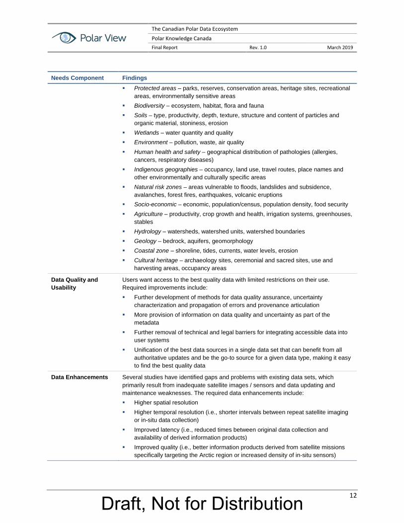
Needs Component Findings Protected areas – parks, reserves, conservation areas, heritage sites, recreational
areas, environmentally sensitive areas Biodiversity – ecosystem, habitat, flora and fauna Soils – type, productivity, depth, texture, structure and content of particles and
organic material, stoniness, erosion Wetlands – water quantity and quality Environment – pollution, waste, air quality Human health and safety – geographical distribution of pathologies (allergies,
cancers, respiratory diseases) Indigenous geographies – occupancy, land use, travel routes, place names and
other environmentally and culturally specific areas Natural risk zones – areas vulnerable to floods, landslides and subsidence,
avalanches, forest fires, earthquakes, volcanic eruptions Socio-economic – economic, population/census, population density, food security Agriculture – productivity, crop growth and health, irrigation systems, greenhouses,
stables Hydrology – watersheds, watershed units, watershed boundaries Geology – bedrock, aquifers, geomorphology Coastal zone – shoreline, tides, currents, water levels, erosion Cultural heritage – archaeology sites, ceremonial and sacred sites, use and
harvesting areas, occupancy areas
Data Quality and Usability
Users want access to the best quality data with limited restrictions on their use. Required improvements include: Further development of methods for data quality assurance, uncertainty
characterization and propagation of errors and provenance articulation More provision of information on data quality and uncertainty as part of the
metadata Further removal of technical and legal barriers for integrating accessible data into
user systems Unification of the best data sources in a single data set that can benefit from all
authoritative updates and be the go-to source for a given data type, making it easy to find the best quality data
Data Enhancements Several studies have identified gaps and problems with existing data sets, which primarily result from inadequate satellite images / sensors and data updating and maintenance weaknesses. The required data enhancements include: Higher spatial resolution Higher temporal resolution (i.e., shorter intervals between repeat satellite imaging
or in-situ data collection) Improved latency (i.e., reduced times between original data collection and
availability of derived information products) Improved quality (i.e., better information products derived from satellite missions
specifically targeting the Arctic region or increased density of in-situ sensors)
Draft, Not for Distribution

The Canadian Polar Data Ecosystem
Polar Knowledge Canada Final Report Rev. 1.0 March 2019
13
Data Access The literature review identified numerous existing portals from which users can access the data about the Arctic that they need. Some of the major portals and the kinds of data and services that they provide include: Arctic Spatial Data Infrastructure (Arctic SDI) Geoportal – developed by the NMAs
of the Arctic nations and providing pan-Arctic coverage, Arctic SDI layers (number) include: biota (8), boundaries (8), Climatology/meteorology/ atmosphere (30), economy (3), elevation (20), environment (27), farming (1), geoscience (10), health (3), imagery/base maps/earth cover (4), location (5), oceans (30), society (4), structure (2) and transportation (1)
Arctic Biodiversity Data Service (ABDS) Data Portal – the data management framework for the Conservation of Arctic Flora and Fauna (CAFF) Working Group of the Arctic Council, the ABDS provides access to the following information types: Species (mammals, fishes, birds, invertebrates, lichen, fungi, etc.); Ecosystems (terrestrial, marine, freshwater, boundaries); Stressors (shipping, oil and gas, harvesting, tourism, climate change); and Indices (arctic species trends, land cover change, protected areas, languages)
GEOSS Portal – operated by the Group on Earth Observations (GEO), the GEOSS Portal provides access to earth observation data in archives from 52 organizations worldwide
Global Cryosphere Watch (GCW) Data Portal – operated by the Norwegian Meteorological Institute on behalf of the World Meteorological Organization (WMO), via linkages with some 10 other data centres the GCW Data Portal provides access to a wide range of cryospheric information in the following categories (number of variables): frozen ground (9), glaciers/ice sheets (11), sea ice (23) and snow/ice (24)
Observing Systems Capability Analysis and Review Tool (OSCAR) – OSCAR contains quantitative user-defined requirements for observation of some 308 physical variables in application areas of WMO (i.e., related to weather, water and climate) and provides detailed information on all earth observation satellites and instruments and expert analyses of space-based capabilities.
Federal Geospatial Platform Open Maps – Open Maps, part of the Canadian federal government’s Open Data portal, provides access to the Government of Canada’s geospatial information (approximately 750 datasets).
Arctic Portal – The Arctic Portal is operated by a not-for-profit organization in Iceland as a comprehensive gateway to Arctic information and data on the internet.
Arctic Data Archive System (ADS) – operated by the Japanese National Institute of Polar Research, the ADS provides access to datasets in the following categories (number of datasets): agriculture (1), atmosphere (38), biosphere (35), climate indicators (148), cryosphere (103), oceans (39) and spectral/engineering (3)
National Snow and Ice Data Center - Located at the University of Colorado, US, NSIDC began in 1976 as an analog archive and information center, the World Data Center for Glaciology. Since then, it has evolved to manage all forms of cryosphere-related data. It is one of the largest cryospheric data centers in the world. Key data portals are the Distributed Active Archive Centre (DAAC), the Frozen Ground Data Center and the Arctic Data Explorer. NSIDC also hosts the ELOKA project outlined in the next section.
Norwegian Polar Data Centre – operated by the Norwegian Polar Institute, the Centre provides access to a full range of official topographical basemap datasets for Norwegian polar land areas and a variety of dynamic thematic map services
Draft, Not for Distribution

The Canadian Polar Data Ecosystem
Polar Knowledge Canada Final Report Rev. 1.0 March 2019
14
(e.g., marine mammals, seabirds and fish, geology, sea ice, glaciers, administrative boundaries)
Global Change Master Directory (GCMD) – operated by the U. S. National Aeronautics and Space Administration (NASA), the GCMD is one of the largest public metadata inventories in the world, providing access to the following categories of data records (number of records): agriculture (1,838), atmosphere (&,848), biological classification (4,255), biosphere (7,046), climate indicators (700), cryosphere (3,109), human dimensions (3,870), hydrosphere (43), land surface (5,405), oceans (11,066), paleoclimate (1,621), solid earth (3,191), spectral/engineering (2,640), sun-earth interactions (439), terrestrial hydrosphere (3,294)
Polar Data Catalogue (PDC) – a repository of metadata and data that describes and provides access to diverse datasets generated by Arctic and Antarctic researchers, the PDC is operated by the Canadian Cryospheric Information Network. The following datasets are accessible (number of datasets): Radarsat images of the Arctic (27,743), Radarsat images of the Antarctic (349), sea ice charts (3,972), other datasets of the Arctic (324)
Arctic Data Explorer – this portal is operated by the U.S. National Snow and Ice Data Centre (NSIDC) and provides access to the following datasets (number of datasets): sea ice (3,260), biology (3,006), permafrost (2,315), meteorology (3,849), economics (696), hydrography (265), oceanography (8,416), biodiversity (338), terrestrial ecology (541), chemistry (4,996), local and traditional knowledge (117)
Exchange for Local Observations and Knowledge of the Arctic (ELOKA) – ELOKA fosters collaboration between resident Arctic experts and visiting researchers and hosts data management. An example, the Atlas of Community-Based Monitoring in a Changing Arctic, showcases the many community-based monitoring (CBM) and Indigenous Knowledge (IK) initiatives across the circumpolar region
Polar Thematic Exploitation Platform (Polar TEP) – developed by Polar View Earth Observation, Polar TEP provides polar researchers with access to computing resources, earth observation (EO) and other data, and software tools in the cloud
Atlas of Community-Based Monitoring in a Changing Arctic – designed to showcase the many community-based monitoring (CBM) and Indigenous Knowledge (IK) initiatives across the circumpolar region, this portal was developed with input from: o Inuit Circumpolar Council (ICC); o Institute at Brown for Environment and Society (IBES); o Exchange for Local Knowledge and Observations of the Arctic (ELOKA); o Inuit Qaujisarvingat: Inuit Knowledge Centre of Inuit Tapiriit Kanatami (ITK); o Carleton University's Geomatics and Cartographic Research Centre; o Nordic Agency for Development and Ecology (NORDECO); o Alaska Ocean Observing System (AOOS); and
o Alaska Sea Grant.
Draft, Not for Distribution

The Canadian Polar Data Ecosystem
Polar Knowledge Canada Final Report Rev. 1.0 March 2019
15
Needs Component Findings
Distribution Formats Users have identified the following requirements in terms of data distribution formats: Most users prefer data formats and access that adhere to recognized standards Ice sheet data users prefer NetCDF as a standard format but also want to have
access to other standard formats Arctic Council users prefer the use of compatible formats based on common
standards to facilitate data consolidation The Arctic Spatial Data Pilot team prefers that data owners make their data
available at standardized interfaces, with temporal dimensions support, ideally such as Open Geospatial Consortium (OGC) Web Feature Service (WFS) or Web Coverage Service (WCS) that support access to the underlying data
The Arctic Spatial Data Pilot team also prefers the use of formats that contain styling information (e.g., the OGC Symbology Encoding standard)
Web Services and Tools
Unified interfaces or a one-stop portal to provide discovery and access to all available polar data across existing metadata catalogs
Data and Service Documents
For users to evaluate the fitness for use of data and services, the following types of documentation are required: A fundamental requirement is for good metadata that provides information on data
quality and uncertainty Metadata generation based on interoperability (e.g., standards-based) protocols A common set of metadata elements relevant across polar sciences, to facilitate
interoperability and sharing between polar data repositories and online portals
Data and Service Availability
See Data Access above
General Knowledge The literature review confirmed that the level of general knowledge about information management policies, geoportals, data infrastructures, and their benefits vary widely within the user community. The community can be generally divided into two types of users, with the following knowledge characteristics: Specialists – these users typically have some education or training in the use of
polar information and enough knowledge and experience to engage with data infrastructures to discover and access the data they need for their applications (e.g., geomatics specialists, engineers, foresters, biologists, geologists). They can use metadata and other tools to assess data fitness-for-use and download to their application the appropriate data.
Generalists – these users typically have very limited education or training in the use of polar information and lack the knowledge and experience to successfully engage with typical data infrastructures (e.g., policy analysts, senior decision-makers, ships captains, Indigenous hunters and fishers, citizens). They require very simple user interfaces and tools to find and interpret the data they need or the help of specialists to produce information products to meet their needs.
Guidance Requirements
Users have identified the following types of requirements for guidance documentation to facilitate use of an international polar data infrastructure:
Policies for the definition of authoritative sources for data;
Policies to establish data sensitivity for aspects which are specific to the north, such as classification related to traditional knowledge data;
Draft, Not for Distribution

The Canadian Polar Data Ecosystem
Polar Knowledge Canada Final Report Rev. 1.0 March 2019
16
Needs Component Findings Policies related to language support (Inuktitut, French, English);
Policies and eventually legislation requiring that all rights off-shore be interoperable and available through a common window;
Policies requiring that any geospatial data submitted to federal agencies (e.g., assessment work, permits, new constructions, etc.) be in digital format, shareable and standardized;
A common projection system for the north (e.g., Lambert Conformal Conic) and thesaurus contents with a classification that addresses objects that are unique to the North;
Implementation based on consideration of Canadian Geospatial Data Infrastructure (CGDI) standards and INSPIRE standards (for interoperability with EU countries in the circumpolar data infrastructure);
Consideration of NetCDF as a standard format for Arctic research data;
Methods for data quality assurance, uncertainty characterization, propagation of errors and provenance articulation;
Provision and communication of quantified information product uncertainties; and
Provision of environment to design, develop and deliver targeted training and capacity-building activities.
Data Incorporation Effort
Consultations are necessary to determine the level of effort required by data providers and staff of the participating NMAs to incorporate their data into the polar data infrastructure:
Metadata standardizations is the biggest concern as it is a pre-requisite to make data searchable and to integrate them into the polar data infrastructure.
The adoption of ISO standards for metadata would help in addressing a wide audience beyond the USA and Canada.
Future Requirements The requirements that users have identified as not yet being fully met and of increasing future importance include: Platforms that add to data access the ability to extract meaningful information from
all available data and to deploy user-created or acquired algorithms/applications; provision of computing resources, storage and networking capabilities, and collaborative tools for user communities to publish, share and discuss their results, information, data and software/code on the platform
Improved data visualization tools for users to easily see and understand both the data they can utilize and the results of their analysis of that data
The use of ontologies (i.e., explicit specification mechanisms to express concepts in a computer-readable language) and semantics (i.e., use of formal languages to control the relationships between symbols and meanings, which allows data to be shared and reused across applications, enterprises, and community boundaries) to facilitate easier search functionality
Archives of historical as well as more recent EO data, weather data, sea ice data, land use and settlement data, etc., to support a range of research activities and the design and construction of new structures and facilities in the Arctic
Significant growth in the use of polar information as the impacts of global climate change (i.e., melting sea ice, ice sheets and permafrost) facilitate increases in marine traffic and cause damage to structures and facilities in the Arctic
Draft, Not for Distribution

The Canadian Polar Data Ecosystem
Polar Knowledge Canada Final Report Rev. 1.0 March 2019
17
Needs Component Findings More sophisticated levels of integration of data from multiple sources (e.g., satellite
sensors, in-situ sensors, Indigenous knowledge Information scaling by bridging the gap between discrete in-situ point
measurements at the local level and large area coverage satellite data to a middle ground where catchment area-sized datasets are needed, scaled up from the local level and scaled down from the broad satellite coverage
Improved veracity of data products through provision of detailed, easy-to-understand descriptions of the applied methods for generation of higher-order products (e.g., retrieval of sea ice thickness) and their limitations
Increased demand for professional value-added, integrated data services that assess all the different data sources and products, and provide information services that integrate the best data and provide it to users
Draft, Not for Distribution

The Canadian Polar Data Ecosystem
Polar Knowledge Canada Final Report Rev. 1.0 March 2019
18
3. Data Providers, Platforms and Facilitators in the Polar Data Ecosystem
This chapter provides a summary overview of key data coordinators, providers and platforms hosting data for the polar regions. A more comprehensive description of this research is provided in Appendix C and an extensive inventory of organizations is included as Appendix D. This Chapter and the related Appendices draw from the Arctic Data Committee’s Mapping the Arctic Data Ecosystem initiative4 as a starting point with significant additional contextual and analytical information added.
A data ecosystem approach focuses on the networked, interconnection of well-defined yet adaptive components that interact and combine in different ways5. This contrasts with highly contained, linear systems that are designed and implemented using only systems engineering approaches. A data ecosystem goes beyond data and services to include governance, establishment of standards and protocols, education, and engagement with user communities. Thus, data facilitators, coordinators and other relevant organizations are included in this discussion. These organizations coordinate and drive collaboration as well as engage in research and education to bring about understanding, agreement and influence the development of the polar data ecosystem.
The current polar data ecosystem is large and complex, with hundreds of actors playing a variety of different roles. This summary focuses on organizations that are acting as “hubs” in the network, either as a data aggregator or mediator, or a coordinator of activities related to polar data. The discussion provides a method for situating various actors within the field to help polar data proponents to organize and prioritize engagement with initiatives. The overview is organized primarily by scale ranging from the international to more locally focused initiatives; however, “discipline” or subject matter can also be a useful organizational dimension. Ultimately, all initiatives are related to the international level given the goal of establishing a polar data infrastructure that links to the larger global data infrastructure.
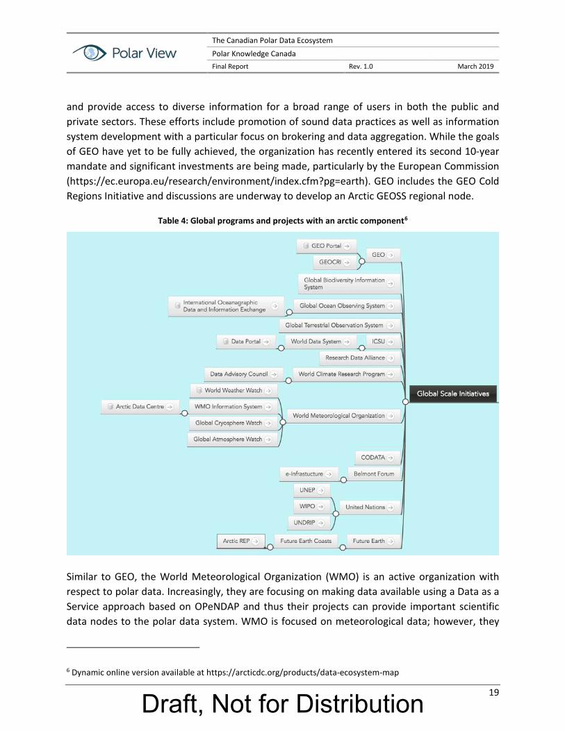
3.1 Global Scale Initiatives with a Polar Component There are many global scale initiatives with a polar component that are, or may be, relevant to the polar data ecosystem (see Figure 1). Global initiatives such as the Group on Earth Observation (GEO) and its Global Earth Observation System of Systems (GEOSS) are working to develop a set of coordinated, independent Earth observation, information and processing systems that interact
4 See https://arcticdc.org/products/data-ecosystem-map 5 Parsons et al 2011 ; Pulsifer et al. 2014 ; Walton 2017
Draft, Not for Distribution
The Canadian Polar Data Ecosystem
Polar Knowledge Canada Final Report Rev. 1.0 March 2019
19
and provide access to diverse information for a broad range of users in both the public and private sectors. These efforts include promotion of sound data practices as well as information system development with a particular focus on brokering and data aggregation. While the goals of GEO have yet to be fully achieved, the organization has recently entered its second 10-year mandate and significant investments are being made, particularly by the European Commission (https://ec.europa.eu/research/environment/index.cfm?pg=earth). GEO includes the GEO Cold Regions Initiative and discussions are underway to develop an Arctic GEOSS regional node.
Table 4: Global programs and projects with an arctic component6
Similar to GEO, the World Meteorological Organization (WMO) is an active organization with respect to polar data. Increasingly, they are focusing on making data available using a Data as a Service approach based on OPeNDAP and thus their projects can provide important scientific data nodes to the polar data system. WMO is focused on meteorological data; however, they
6 Dynamic online version available at https://arcticdc.org/products/data-ecosystem-map
Draft, Not for Distribution

The Canadian Polar Data Ecosystem
Polar Knowledge Canada Final Report Rev. 1.0 March 2019
20
also connect sea ice and other kinds of data through programs such as the Year of Polar Prediction.
There are other domain-specific international data distribution networks that make polar data available. In the oceans domain, the International Oceanographic Data and Information Exchange (IODE) brings together oceanographic data from National Oceanographic Data Centers and other sources. In the domain of ocean life, aggregation programs such as the Global Biodiversity Information Facility (GBIF) and the Ocean Biogeographic Information Service make metadata and data available. While these programs are organized at a global level, they provide a conduit to location-specific polar data. These information resources are large; however, additional research would be required to establish the specifics of using available data in an interoperable environment.
In addition to global scale data providers, there are a number of important international bodies focused on the enhancement of data management methodologies, establishment of technical standards and driving discussions around data policy and other topics. These groups include the Research Data Alliance, the International Council of Scientific Union’s Committee on Data (CODATA), and Belmont Forum e-Infrastructures and Data Management Collaborative Research Action. The activities taking place under these initiatives are vast and thus fully connecting polar data development to these bodies may not be necessary or practical. An appropriate level of engagement should be considered to ensure that developments from these groups can be leveraged for the benefit of polar data, and to avoid duplication of effort.
3.2 Pan Arctic Initiatives There are a number of international Arctic initiatives that are relevant in terms of data resources, facilitation of community building and development or adoption of standards and protocols (see Figure 2).
The Arctic Data Committee (ADC) is jointly sponsored by the International Arctic Science Committee (IASC) and the Arctic Council-endorsed Sustaining Arctic Observing Networks program. The ADC has several charges including promoting ethically open data, facilitating the adoption of standards, and establishing expert groups to make concrete progress on specific issues. In recent years, the ADC has been a lead organizer of a number of community events including the Polar Connections Interoperability Workshop (Italy, 2016), Polar Data Planning Summit (USA, 2018), and the Polar Data and Systems Architecture Workshop (Switzerland, 2018)7. The results of these meetings are being combined in a report that will be published in the
7 https://arcticdc.org/meetings/conferences
Draft, Not for Distribution

The Canadian Polar Data Ecosystem
Polar Knowledge Canada Final Report Rev. 1.0 March 2019
21
second half of 2019. The ADC has co-convened international working groups on federated search, semantics and mapping the international Arctic data ecosystem.
The Arctic SDI is endorsed by the Arctic Council along with a number of other data organizing and producing bodies. For example, the Conservation of Arctic Flora and Fauna’s Circumpolar Biodiversity Monitoring Program produces the Arctic Biodiversity Data Service. Analyzing Arctic Council projects over decades reveals many data resources. A study is currently being carried out to identify Arctic Council reports and link them back to source and published data.
Arctic Council endorsed bodies such as the Sustaining Arctic Observing Networks program are increasingly working to bring together Arctic observing and data actors to ensure overall interoperability across the community and strong linkage to the design of the international Arctic observing system. Specifically, the Arctic Data Committee and many partners have been convening events and generating products to achieve their objectives (see https://arcticdc.org/about-us/adc-purpose).
Draft, Not for Distribution

The Canadian Polar Data Ecosystem
Polar Knowledge Canada Final Report Rev. 1.0 March 2019
22
Table 5: Selected Arctic Data Initiatives
There are many other Arctic-wide projects and programs. Of particular note is the recent funding of a circumpolar observing and research project by the European Commission’s Horizon 2020 program being organized under the EU Arctic Cluster (see C.2.2). While funded by a particular region, these projects and programs are aiming to be circumpolar in scope and many have significant data components.
Coordination bodies such as the European Polar Board and EU-PolarNet address both regions.
Draft, Not for Distribution

The Canadian Polar Data Ecosystem
Polar Knowledge Canada Final Report Rev. 1.0 March 2019
23
3.3 National Polar Initiatives Many countries establish organizations with a polar mandate (see Figure 3) (e.g., Japan, Norway, China, etc.). As a result, there are a number of projects and data resources that relate to both the Arctic and Antarctic regions. For example, although initially focused on the Antarctic, the British Antarctic Survey now manages the arctic research and data program for the U.K. Similarly, the National Snow and Ice Data Center (NSIDC) in the U.S., manages data for the Arctic, Antarctic, and high mountain regions.
Table 6: Selected National Polar Data Initiatives
While national programs are not always comprehensive in terms of representing or being aware of all polar data activities in their jurisdiction (e.g., university-based data may not be readily visible or available through national programs), they are critical nodes in the polar data system. In some cases, strong connections are being made among all national nodes. Such is the case for the Interagency Arctic Research Policy Committee (IARPC) in the U.S., the National Institute for Polar Research in Japan, and an emerging network in Canada called the Canadian Consortium for Arctic Data Interoperability (CCADI) that is strengthening links between government and academia.
Draft, Not for Distribution

The Canadian Polar Data Ecosystem
Polar Knowledge Canada Final Report Rev. 1.0 March 2019
24
The situation in Canada is illustrated in Figure 4.
Table 7: Limited Selection of Canadian Arctic Data Initiatives
Appendix C3 provides a broad overview of many national initiatives.
3.4 University Polar Initiatives Universities play a major role in collecting, managing, using and preserving polar data. For decades, university-based researchers have been collecting data on the physical and social environments. For example, the Arctic Institute of North America has a long history of managing Arctic data and metadata. Two decades the Canadian Cryospheric Information Network at the University of Waterloo was developed, followed by the establishment of the Polar Data Catalogue during the International Polar Year 2007-09. Other Canadian universities are engaged
Draft, Not for Distribution

The Canadian Polar Data Ecosystem
Polar Knowledge Canada Final Report Rev. 1.0 March 2019
25
in Arctic data management, with many already publishing or planning to publish data using service-oriented approaches. The CCADI previously mentioned is linking a number of these initiatives. At the international level, other examples exist such as the NSIDC at the University of Colorado, the Polar Geospatial Center at the University of Minnesota, and the NSF Arctic Data Center at the University of California Santa Barbara.
These cases are examples of well-developed or emerging data centres. However, significant volumes of data produced by the university sector still fall into what is known as the “long tail of data” – a very large number of small data collections that may not be easily discoverable or professionally managed in a repository or stable cyberinfrastructure. There is a significant opportunity for the polar data community to play an important role in addressing the problems presented by the “long tail” data collections (e.g., lack of discoverability or usability, data loss, etc.). Data protocols, training materials and infrastructure can help to find or create a stable, managed location for some of these data. This can be done by connecting with individual researchers, laboratories or universities, or assisting established data centers in taking a service-oriented approach where this is not already the case.
3.5 Initiatives Focused on Local and Indigenous Knowledge Indigenous and local observations and knowledge, and derived data and information, are increasingly being recognized as valuable by researchers, governments and society. Community based monitoring programs, such as the Atlas of Community Based Monitoring (http://www.arcticcbm.org), are producing data and, where appropriate, making them available. Working in this space can be challenging due to different ontology and epistemology, a wide variety of local contexts, variable funding models and technical challenges (http://www.inuitcircumpolar.com/community-based-monitoring.html; Johnson et al. 2015). Significant investments are being made though, data sharing capacity can be expected to increase in coming years (cf. https://www.aadnc-aandc.gc.ca/eng/1509728370447/1509728402247).
A number of organizations and programs focused on this type of data sharing already exist in Canada and beyond, including the Inuit Knowledge Centre at ITK and regional organization partners, the Geomatics and Cartographic Research Centre at Carleton University, the Exchange for Local Observations and Knowledge of the Arctic (ELOKA) program at University of Colorado, the EU INTAROS project, and many others.
3.6 Not-for-Profit Initiatives The not-for-profit sector is also making important contributions. As indicated in Appendix C6, significant investments are being made by this sector, and major cyberinfrastructure and data platforms are being developed. Collectively, members of coordinating bodies such as the Arctic
Draft, Not for Distribution

The Canadian Polar Data Ecosystem
Polar Knowledge Canada Final Report Rev. 1.0 March 2019
26
Funders Forum are investing millions of dollars in data producing and management projects, particularly in the area of community-driven or oriented monitoring and data management projects. Other not-for-profit organizations, such as Polar View, are bringing together different data-oriented organizations to develop data infrastructure such as the ESA-funded Polar Thematic Exploration Platform. Polar View is also engaged in a number of community coordination projects. This sector is increasing in size and stands to play an important role in the broader Arctic data ecosystem.
In summary, the current arctic data system is large and complex, with hundreds of actors playing a variety of different roles. Engaging with all of these actors directly is not practical for POLAR. There are a number of existing “hubs” that can facilitate access to data that are relevant. Moreover, these hubs can allow for efficient connections between POLAR and others in the areas of policy, development or adoption of standards and protocols, and general planning for interoperability.
Draft, Not for Distribution

The Canadian Polar Data Ecosystem
Polar Knowledge Canada Final Report Rev. 1.0 March 2019
27
4. Polar Data Infrastructure Implementation Issues In order to support polar communities, polar data infrastructure must address requirements that can be broadly classified into two categories:
User’s expectations of the data infrastructure’s functional capabilities; and
User’s expectations of non-functional aspects relating mainly to the infrastructure’s usability, such as performance, security and reliability, i.e., the Quality of Service.
The following sections address some of the main design trends for data infrastructure, driven by requirements falling into one or both categories.
4.1 Data Preservation and Stewardship Developing an underlying infrastructure that supports development of data systems that serve users requires that most data be preserved over time. Preservation requires more than simply backing up files. Data stewardship is required to ensure that collections are accessible and usable over time. This may include migrating to new platforms or formats, changing semantics, or restructuring data for use with new tools. Although investment priorities still tend to be focused on innovation, the International Polar Year and subsequent activities have highlighted the need for a long-term preservation and stewardship strategy and implementation plan.
4.2 Data Discovery Data must be findable to be usable. The goal of “single-window” data discovery has been identified as a polar user community need for more than a decade. The polar data community has confirmed that enabling federated search, the ability to search multiple data catalogues simultaneously using a single interface, is a fundamental data infrastructure requirement. An international group has been formed to facilitate the development of federated search for the polar community (see https://arcticdc.org/activities/core-projects/federated-search). Ultimately, realizing federated search will require the establishment of common search protocols and vocabularies combined with technologies that enable metadata sharing. Contributions by individual countries and organizations are necessary and Canada and POLAR are well positioned to take a leadership role in this area.
4.3 Open Data The trend of open data should be encouraged because it maximizes usability. The increased availability makes it easier for scientists and decision makers to quickly correlate multiple data sets. In Canada, Europe, USA, Australia and elsewhere, government organizations are in various stages of implementing data platforms, with a general trend towards open access. Data infrastructures are expected to deliver and comply with standards around open data. The OGC is
Draft, Not for Distribution

The Canadian Polar Data Ecosystem
Polar Knowledge Canada Final Report Rev. 1.0 March 2019
28
the foremost provider of open geospatial standards. It has a wide membership and has defined many standards. However, some of the OGC standards (e.g., for catalogues) are not regarded as being good enough, are too ambiguous and, as with many standardization bodies, the standardization process is rather slow. Therefore, other standards (de facto or de jure) might have to be used and it is unclear which standards will emerge as the main ones in use. This is not likely to be clear for a number of years. Whatever technical solutions are developing for data infrastructures, constant monitoring of how standards evolve is necessary in order to provide relevant tools to the polar community.
4.4 Data Access and Use Issues While the requirements for polar data are extensive and serve a broad range of scientific and operational applications, access to and use of the required data is impeded by a number of data issues. The following sections provide a brief overview of these issues, which impact the implementation of a polar data infrastructure (Open Geospatial Consortium, 2017).
4.4.1 Missing Metadata for OGC Web Services Content
Although the use of OGC Web services is well-adopted by the geospatial community, served data often lacks proper metadata, which makes it difficult to interpret the services’ offerings. For instance, many WMS layers use default or empty titles, abstract, keywords, etc., making it difficult for catalogs to help clients with their data search. Also, often only the service provider is mentioned in the metadata and the original data provider is missing, which causes problems for proper citations.
4.4.2 Data Formats
Proprietary/custom formats can make data integration very time consuming. This situation is often observed at portals that feature a more FTP-like data access rather than a Web service with rich query interface. Using an open, interoperable standard with support for temporal dimensions (e.g., NetCDF, OGC WCS) avoids custom development tasks related to the integration of these data.
4.4.3 Styling of Vector Data
Vector data is often made accessible using a format that does not contain styling information (e.g., CSV file or ESRI Shapefile). While an application can read such a file relatively easily, having a meaningful style greatly helps to interpret the data. The OGC Symbology Encoding standard, a stand-alone styling definition language, is one example standard that can solve this problem. It is ideally suited for sharing of vector data with data consumers, possibly through a registry/discovery service such as an OGC CSW.
Draft, Not for Distribution

The Canadian Polar Data Ecosystem
Polar Knowledge Canada Final Report Rev. 1.0 March 2019
29
4.4.4 Temporal Characteristics
To analyze the evolution of some characteristics requires the use of the temporal dimension, which represents snapshots of the data at different points in time. Management of time in data has some impacts, the major one being the size of the dataset. Beyond the acquisition and storage challenge, the distribution of spatio-temporal datasets is not always easy. Some standard data formats like NetCDF and Grib are suited for multidimensional data. Raster data is usually organized following a specific directory or filename structure to represent the temporal dimension since often multiple acquisitions are not merged to be stored in a single file container. As far as distribution of temporal data is concerned, OGC web service standards completely fulfill the requirements (e.g., WMS, WMTS, WFS, WCS).
4.4.5 Vendor Specific Solutions
Many data sets provide RESTful service interfaces that are based on open standards but are not OGC standards. Since it is generally simple for the data provider to also provide standardized OGC Web service interface support (e.g., WMS or WFS), failure to enable OGC service interfaces represents a lost opportunity for the data provider to increase exchange of their information.
4.4.6 Shared Semantics and Quality Information
It is easier to reuse data when information about their quality and fitness-for-use is available, and when technical and legal barriers for integrating these into the user systems are removed. The first condition, quality, requires that rich and meaningful metadata be used, while fitness for use requires the involvement of technical arrangements that ensure interoperability. Semantic issues in polar data sharing and service interoperability have been recognized in the literature for a while. Though some issues have generally been addressed successfully with GML and OGC Web service interface standards, semantics still poses several problems, including:
discovery of data sets and services based on keywords;
rigid metadata structures;
missing semantics on technical terms; and
missing matching capabilities for equivalent or related terms or symbols.
A key concept of the Semantic Web is the usage of URI as identifiers for objects, predicates, and subjects. If URIs would be used for keywords, discovery and usage of data for the polar regions would be improved.
4.4.7 Aggregation and Data Fusion
Collaboration between organizations (e.g., NMAs) should be encouraged to build aggregated data sets. Tremendous value is created when the best data sources are unified in a single data
Draft, Not for Distribution

The Canadian Polar Data Ecosystem
Polar Knowledge Canada Final Report Rev. 1.0 March 2019
30
set that can benefit from all authoritative updates and be the go-to source for a given data type, making it easy to find the best quality data. Data fusion steps help to efficiently integrate a large number of small files.
4.5 Polar Data Platforms The development of polar data infrastructure is occurring within a context of rapid growth in the provision of polar data and change in user expectations about access to and use of such data. The data available on the state of the planet is growing in precision, volume, velocity, variety, and value, increasing the complexity of scenarios for data exploitation, as well as the resources required by the communities using the data. A number of groups are developing innovative approaches to the creation of polar data platforms. These approaches share some common characteristics:
Individual parameters by themselves are not nearly as valuable as integrated data sets. Therefore, the trend is to provide data platform users with access to a wide range of data types that they can be exploited together.
With the explosion of the data that are available, data discovery and analysis is becoming increasingly challenging. As a result, the trend is to include sophisticated data visualization tools to enable data platform users to easily see and understand both the data they can utilize and the results of their analysis of that data.
The quantity of data available, especially EO data, means that it is often not practical for each user to download the data they need to their local environment. Rather, the trend is to bring the algorithms to the data and only download the results of their calculations.
Working with such large data sets is often computationally intensive. This means that modern data platforms need to provide users with highly capable ICT infrastructure for data processing, storage, and networking.
Research is increasingly collaborative. Therefore, the trend is to combine data and computation capabilities with the tools required for such collaboration and the ensuing dissemination of research results.
The increasing diversity of data sources and the need for scientific and operational communities to access data unfamiliar to them makes it essential that useable data quality information is available for all products.
Draft, Not for Distribution

The Canadian Polar Data Ecosystem
Polar Knowledge Canada Final Report Rev. 1.0 March 2019
31
There is an aversion to lock-in with any one technology or supplier. Therefore, many data platforms use open source software where possible and are platform independent, often hosted in the cloud (see Section 4.2).
In summary, modern polar data platforms are going far beyond traditional data portals by combining multiple functionalities and making them available in the cloud. Examples of such platforms that are currently being developed include the Polar Thematic Exploitation Platform (Polar TEP) being sponsored by the European Space Agency, the INTAROS Integrated Arctic Observing System platform (iAOS) being sponsored by the European Commission, and the Arctic-Boreal Vulnerability Experiment (ABoVE) Science Cloud being sponsored by NASA. More work needs to be done to make these platforms truly interoperable.
4.6 Cloud Computing Historically, data providers and value-added service providers have relied on proprietary data storage and compute solutions, which have led to an inefficient and costly use of computing resources. Indeed, this is still the case for many data portals in operations today. With the increasing availability of affordable cloud-based ICT resources offered as a commodity, increasingly data providers and value-added service providers are migrating to cloud architectures to serve their clients. The past, inefficient way of moving large amounts of data to processing infrastructures and to the user, is now replaced by an inverse trend in which users access and process data in the cloud. This allows wider access to adequate IT infrastructure at an affordable price.
Cloud computing is used when applications, services and datasets are no longer located on individuals' computers, but distributed over remote facilities operated by third party providers (e.g., AWS, Azure, Google). In cloud environments, users can allocate computational resources without requiring human interaction with a resource provider (on-demand self-service). Examples of such resources include storage, processing, memory, network bandwidth, and virtual machines. As mentioned in Section 4.1, the European Space Agency is pioneering the development of Exploitation Platforms, which extends the data infrastructure model from a “portal” to a “platform” that not only provides easy and convenient access to data but also provides software and computing resources to analyze data and produce information products in the cloud. In addition, OGC Testbed 14 includes an exploitation platform initiative in recognition of the challenges of rapidly growing data volumes. As stated in the OGC January 2, 2018 announcement, “Making arbitrary applications available on cloud infrastructures or exploitation platforms in a standardized way, is a key technology for Big Data in general and particularly true for Earth Observation satellite data processing. When the transport of large
Draft, Not for Distribution

The Canadian Polar Data Ecosystem
Polar Knowledge Canada Final Report Rev. 1.0 March 2019
32
amounts of data is not feasible, or simply not cost efficient, processes need to be shipped and executed as closely as possible to the actual data.”8
These resources and their capabilities are available over the network via standard mechanisms and simple web service interfaces. The providers of resources (physical and virtual resources) have to cope with multiple users and their dynamically changing demands. From the user's perspective, the availability of resources in the Cloud often appears to be unlimited.
The adoption of cloud computing allows organizations and governments to better plan their data infrastructures; for example, a project can start small with one or two servers and with a limited storage capacity, and grow on demand, provided the overall architecture of the infrastructure allows this scalability. Cloud resources can also grow on demand more dynamically, e.g., to maintain performance during IT resource demand peak times.
Cloud computing helps mitigate the usual issues with users related to performance, availability, or reliability, since everything can be fully backed up and automatically deployed. The main benefits of cloud computing are simplified deployment and maintenance of services, and reduced costs of providing content and applications with a high quality of service.
8 http://www.opengeospatial.org/pressroom/pressreleases/2716
Draft, Not for Distribution

The Canadian Polar Data Ecosystem
Polar Knowledge Canada Final Report Rev. 1.0 March 2019
33
5. Canadian Polar Data Community9 Over several decades, and since the International Polar Year 2007-09 in particular, the Canadian polar community has worked to develop a polar data ecosystem that is integrated into the global system. In summarizing several workshops and reports, some key desired attributes for such a system are evident:
1. Ethically open access to data;
2. Data preserved over time (sustainable);
3. “Single window” discovery of and access to data through easy to use tools;
4. Easy access to data through “data as a service” (live, online);
5. Interoperability to support sharing and integration of data among various information systems in a useful and meaningful manner;
6. Inclusive of Indigenous and local perspectives and data;
7. Access to “big data” and powerful analytical tools (e.g. cloud platforms); and
8. Cost effectiveness.
The following sections examine the history and current status of the Canadian polar data community’s efforts.
5.1 Past Efforts Over the past two decades, the polar research community has increased the scope and scale of its activities, including efforts to obtain, manage, use, and steward relevant data. In Canada, research and Indigenous Knowledge are the basis for the evidence-based decision making that is needed to improve the lives of northerners and all Canadians and for understanding the Arctic system, its connections to the global system, future trajectories of change, and ways to reduce and mitigate the negative impacts of environmental and other changes. Simultaneously, Canadian scientists engage in Antarctic research to advance our knowledge of system dynamics at the southern pole and the relationship of the Antarctic system to the global system and to global change [14, 15].
9 Much of this chapter reflects the views of the Canadian polar data community as reflected in the 2nd Canadian Polar Data Workshop report. The workshop and report were coordinated by the Canadian Consortium for Arctic Data Interoperability (CCADI), the Canadian Cryospheric Information Network (CCIN), and the Polar Data Catalogue (PDC). (CCADI/CCIN/PDC (2018) Report of the 2nd Canadian Polar Data Workshop: A Roadmap to the Future of Polar Data Management in Canada. AINA Occasional Report 1. Arctic Institute of North America, University of Calgary, Calgary).
Draft, Not for Distribution

The Canadian Polar Data Ecosystem
Polar Knowledge Canada Final Report Rev. 1.0 March 2019
34
In this context, the Canadian polar data community has grown in size, capability, and complexity, enhancing the need to identify and connect the various individuals, groups, and organizations which produce, use, and steward polar data. With the need to design and establish an effective data management network in mind, in 2015, the 1st Canadian Polar Data Workshop (CPDW1) was an initiative led by the academic sector to address the siloed nature of polar data management in Canada. CPDW1 brought the Canadian polar data management community together to begin discussions on national-scale coordination of management activities, including project planning, governance, and collaboration with stakeholders and rights holders.
Prior to the CPDW1, related efforts with a broader-than-polar scope include the 2011 Canadian Research Data Summit [16], advancement of the Canadian Open Government portal [17], the development of the Open Science Action Plan[18], the establishment of the Leadership Council for Digital Research Infrastructure[19] and of Research Data Canada[20].These activities began to provide a vision for defining roles and building a national research data management infrastructure and policy environment in Canada. Indeed, in 2015 Canada was behind many other nations in this respect.
From 2015 to the present, activities to coordinate and advance polar and non-polar data management in Canada included development of: 1) the Canadian Consortium for Arctic Data Interoperability[21]; 2) the Marine and Arctic Spatial Data Infrastructures[22]; 3) the Canadian Geospatial Data Infrastructure [23]; 4) the Federal Geospatial Platform at the Department of Fisheries and Oceans Canada; 5) the Portage Network [24] of the Canadian Association of Research Libraries (CARL); 6) the Tri-Agency Open Access Policy on Publications [25]; ( 7) the Tri-Agency Statement of Principles on Digital Data Management [26]; and 8) the Leadership Council for Digital Research Infrastructure [27]; among others.
Internationally, polar-data-focused activities include: 1) the creation of the Arctic Data Committee [28], an initiative of the International Arctic Science Committee (IASC) and the Sustaining Arctic Observing Networks (SAON) program; 2) the gathering of the international Arctic and Antarctic data communities at the Polar Data Forum I in 2013 [29]; and again at 3) the Polar Data Forum II in 2015 [30]; the ADC Interoperability Workshop and Assessment Process [31]; the Polar Data Planning Summit 2018 [32]; the 4th Meeting of the Arctic Data Committee [33] which took place in Montreal in 2017 and was a precursor to the 2nd Canadian Polar Data Workshop; and the Fifth Meeting of the Arctic Data Committee 2018 in Geneva.
Canada is well-represented in international polar-data-relevant venues, participating on the ADC, the Standing Committee on Antarctic Data Management (SCADM) of the Scientific Committee on Antarctic Research (SCAR) and the Research Data Alliance. Canadian polar data organizations are also members of the World Data System of the International Council for Science (ICSU) and the
Draft, Not for Distribution

The Canadian Polar Data Ecosystem
Polar Knowledge Canada Final Report Rev. 1.0 March 2019
35
Open Geospatial Consortium (OGC). Canadian polar data community members are involved in many activities to connect Canada to international data management systems. These include the World Meteorological Organization (WMO) Integrated Global Observing System (WIGOS) metadata initiative, and the intergovernmental Group on Earth Observations (GEO) Cold Regions Initiative (GEOCRI). Canadian scientists and data managers are also engaged in projects such as the European Commission-funded Integrated Arctic Observation System (INTAROS) project and the International Network for Terrestrial Research and Monitoring in the Arctic (INTERACT) both of which have significant data management and data use components.
As a result of these many national and international consultations, workshops, and initiatives there has been a significant increase in collaboration and substantial progress on identification of polar data management needs, ways to address those needs. However, a national, integrated data network and governance structure are still necessary for Canada.
5.2 Collaboration, Coordination And Governance As the community of polar data producers, users and stewards has grown substantially over the past decade, so has the need to identify and connect these groups and to produce a national plan for coordination of Canadian polar data activities and systems. The polar data landscape, while complex, is also increasingly organized with a move away from centralization towards a system of systems approach. Information is shared across scales and knowledge domains and the ecosystem model provides a good metaphor. There are many successful examples of collaboration and coordination within this ecosystem such as Inuvialuit Indicators, and the Canadian Consortium for Arctic Data Interoperability.
Canada is well-placed to create and execute a governance model for the country. There is commitment and a vision, and a principles and guidelines document already in place - Data Management Principles and Guidelines for Polar Research and Monitoring in Canada (Canada 2017) - that can inform the governance structure.
Defining a flexible and adaptable governance structure is key to moving beyond a project-specific approach to collaboration and coordination. It is a community-scale process requiring established and agreed upon principles and core values while recognizing the diversity within, and the complex, multi-actor nature of, the community. Engagement with governance and planning requires resources; some individuals or organizations are more easily engaged than others. Thus, to avoid uneven representation, it is imperative to use a process that offers ample opportunity for diverse input through mechanisms such as community review and consensus building. Examples of entities and organizations that should be engaged in the governance building process are shown in Table 8. Establishing fundamental principles of operation and the core
Draft, Not for Distribution

The Canadian Polar Data Ecosystem
Polar Knowledge Canada Final Report Rev. 1.0 March 2019
36
values of the governance system and structure are key to broad acceptance by the polar data community.
Table 8: Polar Data Governance Participants
Indigenous Organizations Territorial and Federal Governments
Funding Organizations with Arctic Investments
Relevant National and International Data Management Entities
Regional Inuit Organizations
Territorial Science Advisors Canadian Foundation for Innovation
Research Data Canada
Inuit Tapiriit Kanatami Federal departments with Polar responsibilities
Social Science and Humanities Research Council of Canada
Research Data Alliance
Inuit Circumpolar Council Canada
Federal Canadian Council on Geomatics
Natural Sciences and Engineering Council of Canada
Arctic Data Committee
Arctic Athabascan Council
Federal Committee on Earth Observations
Canadian Institutes for Health Research
Group on Earth Observations Cold Regions Initiative
Gwich’in Council International
Operational agencies Standing Committee on Antarctic Data Management
5.3 Interoperability Interoperability is an immense challenge encompassing, as it must, both the technical and the human. The polar data community covers a diverse universe, with many domains and areas of expertise spanning the physical, biological, health and social sciences, and in the Arctic, Indigenous Knowledge. There are diverse semantics (linguistics and logic), and data collection and management methods.
Interoperability is often addressed in silos (i.e., interoperability of single datasets), but ultimately it needs to cut across types and categories of data. This challenge is not inconsequential. Data will continue to be collected, new data types will emerge, data rescue will progress, data repositories themselves will also continue to be established and to grow, and the needs for data will become increasingly diverse with timely and easy access ever more important. The actions towards establishing interoperability are, and must be, iterative, and they must be maintained through multi-decadal support from many sources. There is a special importance and obligation to ensure the effective preservation and archiving of data for future use, and long-term care is a shared responsibility among Federal, Territorial, Academic and Indigenous partners.
5.4 Engagement of Data Providers and End Users The end user communities for polar data are many and varied, and any given user may be looking for data that is project specific, issue specific, or for a particular class or classes of data that may have be obtained in a number of different ways under different projects or programmes. Thus,
Draft, Not for Distribution

The Canadian Polar Data Ecosystem
Polar Knowledge Canada Final Report Rev. 1.0 March 2019
37
end users have different needs, expectations, and desired outcomes when they seek to access and use polar data. Both data providers and end users need to be informed about the direction the polar data management community is heading with respect to matters of data citation, open access, interoperability, and open source code among other matters. While many data providers are already on board, still many others have questions and concerns about the changes coming both with respect to policy and technical developments. Involving providers and users in data workshops, and specifically in technical workshops, through the application of a use-case approach has proven beneficial in other contexts and could work equally well in Canada provided there is sufficient time and resources for follow through by all actors. Much remains to be done in this regard.
5.5 Policy and Funding for Sustaining Data Management The level of funding for Canadian polar projects and polar data management is somewhat unclear. A recent effort to determine Tri-Council investment in Arctic research illustrates the difficulties of assessing support for basic research exclusive even of infrastructure funding and data management [34]. The cost of data management needs to be established and considered in the context of the long-term, including such issues as: the Tri-Agency digital data management policy, Canada’s commitment to the Arctic Council Agreement on Scientific Cooperation in the Arctic, and Indigenous data policy requirements. In addition, it is necessary to assess how the implementation of specific data policies may be leveraged to either reduce costs, or provide value added to current and past investments in the collection of polar data.
In Canada, for polar data management, and polar research in general, long-term planning (10-15 years or more) is encouraged for projects that includes, where appropriate, partnerships with agencies and organizations that have a vested interest in successful, sustained data management (for example the Coast Guard, weather services, etc.). Even though most research is funded in 3-5 year cycles, there are opportunities for extended support and the community needs to begin to leverage non-traditional sources such as from operational agencies and others who require continuing access to polar data (Table 9).
Draft, Not for Distribution

The Canadian Polar Data Ecosystem
Polar Knowledge Canada Final Report Rev. 1.0 March 2019
38
Table 9: Possible Data Management Funding Sources
Duration of Support
National International
Short Term (1-5 years)
Canadian Foundation for Innovation Tri-Council funders Polar Knowledge Canada Private Sector Philanthropic Foundations
European Commission European Space Agency National Research Funders Belmont Forum Private Sector Philanthropic Foundations
Medium Term (5-10 years)
CANARIE Compute Canada
Arctic Economic Forum
Long Term (multi-decadal)
Government Departments with Polar mandates Government agencies depending upon Polar data Operational agencies depending upon Polar data
Government Departments with Polar mandates Government agencies depending upon Polar data Operational agencies depending upon Polar data
Ultimately, the Community must make inroads with decision makers to ensure the necessary long-term support that is needed to manage Canada’s polar data to best meet the needs of the broad user community. The recent Joint Statement of Ministers on the Occasion of the 2nd Arctic Science Ministerial specifically commits to enhance and develop collaborative activities under three themes, the first of which is “Strengthening, Integrating and Sustaining Arctic Observations, Facilitating Access to Arctic Data, and Sharing Arctic Research Infrastructure.” This bodes well for the future of polar data management in Canada, and the Canadian community should be prepared to address opportunities here as they arise, as well as to speak to this commitment from Canada as needed. The community is in an excellent position to advocate to for long-term support while utilizing existing short-term funding opportunities as much as possible.
Draft, Not for Distribution

The Canadian Polar Data Ecosystem
Polar Knowledge Canada Final Report Rev. 1.0 March 2019
39
6. Recommend Activities While the polar data community has collaborated to make significant advances in data management and availability, there is still much to be done. At the Second Canadian Polar Data Workshop10, the Canadian polar data community established a vision for the future of polar data management in Canada that will guide subsequent community activities:
Canadian Polar Data Community Vision Statement
Canada, as a global leader in polar research, shares polar research data and products with Canadians and the rest of the world and, through collaboration at home and abroad, supports and informs the development of relevant policy and the technical and human systems that will improve all aspects of polar data management from acquisition and curation to dissemination and use.
Guided by this vision, and in collaboration with their international colleagues, the Canadian polar data community has recommended activities in the areas outlined in the following sections.
6.1 Polar Data Community Governance The community is committed to establishing a governance structure that will facilitate the vision and that will include all interested stakeholders and rights holders. There is a desire to be equitable, diversified, and inclusive in moving forward.
As a first step, the Second Canadian Polar Data Workshop participants established the Canadian Polar Data Coordination Committee (CPDCC) to lead the discussion on governance issues and design of a governing body for the Canadian polar data community. The CPDCC will conduct itself according to the following guidelines:
Ensure that Indigenous people and organizations are integral to governance through representation, input and action;
Ensure representation from the operational communities;
Ensure representation from the academic research community; and
Ensure representation from the Federal family.
Polar data community governance activities will include:
10 Report of the 2nd Canadian Polar Data Workshop, 30-31 May, 2017, Ottawa.
Draft, Not for Distribution

The Canadian Polar Data Ecosystem
Polar Knowledge Canada Final Report Rev. 1.0 March 2019
40
Ensuring an understanding across many scales of the nature of the polar data community (who is doing the work, where, what systems, etc.) and what it is collectively trying to achieve.
Implementing a plan to facilitate coordination of polar data activities and to enhance technical and human interoperability through a robust polar data infrastructure.
Improving communication, outreach, and coordination within the international polar community and with external stakeholders.
Representing the interests of the polar data community as a whole through white papers, proposals and advocating on behalf of the data community.
6.2 Internal and External Collaboration The Canadian polar data community’s vision requires community building, collaboration, and coordination of efforts to develop policies and systems for improving data management across academic, sectoral, cultural and jurisdictional boundaries. Activities will include:
Building effective working relationships with established Canadian polar data management organizations.
Continuing to strengthen linkages with international polar data partners.
Collaborating with all interested Canadian stakeholders in areas of common interest.
Working with non-polar communities of practice in the data management world to obtain expertise and support.
6.3 Polar Data Community Resources The most import conclusion from all of the studies and workshops to date is that making significant progress will require adequate financial, technical, and human resources. Activities in this area will cover obtaining funding and building data management capacity within the community.
Securing long-term resources is especially critical for community based monitoring. Community members need appropriate training, equipment, and infrastructure and other support in order to carry out monitoring efforts, and partnering scientists, funders and government workers also need to develop new skills, capacities and knowledge areas. In addition, individual community programs may not have the capacity to summarize and synthesize data to share with decision makers beyond the community level, which suggests an important role for networks and regional CBM initiatives in linking community observing needs to larger information-sharing and funding platforms.
Draft, Not for Distribution

The Canadian Polar Data Ecosystem
Polar Knowledge Canada Final Report Rev. 1.0 March 2019
41
Funding
Identify diverse funding and other resources for sustained support of a national, distributed Canadian data management infrastructure.
Prepare a cost/benefit analysis of polar data management that allows a cogent economic and societal benefits argument for long-term support.
Develop a sustainability plan that directly engages funders
Capacity Building
Develop the capacity of data suppliers to collect and provide data in formats compatible with the polar data system.
Develop mechanism to support and build capacity among Indigenous communities and organizations so that they may fully participate in data initiatives.
6.4 Polar Data Discovery and Access The overarching purpose of the polar data management community is to promote and facilitate international collaboration towards the goal of free, ethically open, sustained, and timely access to polar data through useful, usable, and interoperable systems. A foundational characteristic of an interoperable data system is the ability to discover data and evaluate it in terms of quality, fitness for use, etc. Activities supporting this goal will include:
Facilitating the adoption, implementation and development (where necessary) of standards.
Improving data discovery mechanisms, including annotation, vocabularies and linked data, crawling based approaches and service availability and reliability.
Developing common metadata elements for use in a “single window” search.
Promoting data publication and attribution so that researchers can make their data available and receive credit for the publication.
Supporting the community in making users aware of existing data.
Consolidating, updating and maintaining observing platform inventories at a global level using a brokering approach.
Developing as necessary policies around data access and ownership that recognize intellectual property rights and the protection of sensitive information.
Draft, Not for Distribution

The Canadian Polar Data Ecosystem
Polar Knowledge Canada Final Report Rev. 1.0 March 2019
42
6.5 Polar Data Systems Interoperability Interoperability, the ability to easily share data across systems and users, is one of the most important priorities identified by the polar data community. An interoperable system must enable data access that can support many different users. This means moving towards a service-oriented model that makes data and processing services available in the cloud, rather than a static download for local processing. This may include visualization or other mediation such as translating vocabularies to make data usable by different communities. Achieving interoperability will require adequate resources, a certain level of standardization, and a connected community. Activities supporting this goal will include:
Developing an infrastructure that goes beyond a portal that provides data discovery and access functionality to a platform that also provides software and computing resources to analyze Big Data and produce information products making use of Cloud computing. With the massive volumes of data (particularly imagery) that are becoming available, processes need to be shipped to and executed as closely as possible to the actual data.
Making connections between prominent cloud platforms for seamless integration of data and results.
Establishing models for sharing algorithms and software within and between platforms.
Streaming user authentication across platforms and integrating resource accounting
6.6 Indigenous Knowledge and Perspectives In this time of change, Indigenous knowledge and the underlying observations of Arctic peoples are more important than ever. Along with the knowledge of non-Indigenous local inhabitants, this knowledge is being increasingly documented and represented as digital data, but the nuances of these data are not well understood by the broader data management and science community. The perspectives of Indigenous people and other northern residents must be heard directly. This will enhance understanding of how Indigenous and local knowledge and observations can be used appropriately.
Data policy development and implementation within Inuit Nunangat should be led by Inuit with support as needed from partners already engaged in data management and related activities. Actions are underway to advance Indigenous community self-determination in collecting, verifying, analyzing, and disseminating Indigenous-specific data and information. Among the entities that can engage here are the National Inuit Data Management Committee and the Inuit regional organizations. There is already movement forward on some policy considerations through Inuit partnerships in entities such as the CCADI, the Arctic Eider Society, and the Exchange for Local Observations and Knowledge of the Arctic (ELOKA). Long-term capacity
Draft, Not for Distribution

The Canadian Polar Data Ecosystem
Polar Knowledge Canada Final Report Rev. 1.0 March 2019
43
building must occur so that Indigenous people can be responsible for data design, collection, management, and application in research and decision making.
Relevant activities will include:
Facilitating the participation of Indigenous Canadians in all aspects of polar data management.
Promoting an integrated approach to development by ensuring that Indigenous Canadians are ‘at the table’ as systems are being collectively designed.
Supporting Indigenous communities in developing protocols that allow for ethical sharing of documented knowledge.
Supporting skills and knowledge development driven by Indigenous Canadians and their representative organizations.
Co-developing with Indigenous peoples and organizations the resources to support Indigenous-led data stewardship efforts and ensuring Indigenous access to polar data and information, and Indigenous Knowledge.
6.7 Other Polar Data Issues There are a variety of other issues relating to the collection, management, and application of data facing the polar data community. These issues include:
Data Preservation and Rescue: Past observations must be continually re-used and re-purposed to increase current understanding. Therefore, data, Indigenous Knowledge (especially of Elders), and all the necessary descriptive information, must be preserved. Too often, preservation is forgotten and data managers must pursue “data rescue” activities. Even current data are at risk of loss. Strategic data rescue programs must be developed, and preservation must be prioritized as a long-term investment and cost-saving measure.
Semantic Interoperability: Communities of practice need to develop terminology and knowledge models that enable users to fully understand the data being shared (e.g. structure, classification systems etc.). In particular, semantic heterogeneity still causes several problems, including: discovery of data sets and services based on keywords; rigid metadata structures; missing semantics on technical terms; and missing matching capabilities for equivalent or related terms or symbols.
Social Science Data: The scope of data that is accessible through the polar data infrastructure must include social science data. There is a need, particularly within Arctic
Draft, Not for Distribution

The Canadian Polar Data Ecosystem
Polar Knowledge Canada Final Report Rev. 1.0 March 2019
44
Indigenous communities, for data and observations that can support decision-making in the context of socio-environmental change.
Support ‘Generalists’: In designing the polar data infrastructure, ensure that the needs of “generalists” are given foremost consideration. These polar data consumers typically have very limited training in the use of polar information and lack the knowledge and experience to successfully engage with typical data portals or platforms. They require very simple user interfaces and tools to find and interpret the data they need.
Data Quality: Support the further development of methods for data quality assurance, uncertainty characterization and propagation of errors and provenance articulation. Users want access to the best quality data available and want the tools to assess their fitness for use. Provision of information on data quality and uncertainty is a critical part of metadata.
Temporal Data: Provide functionality to handle the temporal dimension of data to meet the growing demand for analysis of the evolution of characteristics over time. Using an open, interoperable standard with support for temporal dimensions (e.g., NetCDF, OGC WCS) will enable users to avoid custom development tasks related to the integration of these data. So-called “data cubes” are a data abstraction to evaluate aggregated data from a variety of viewpoints, including time series analyses.
Draft, Not for Distribution

The Canadian Polar Data Ecosystem
Polar Knowledge Canada Final Report Rev. 1.0 March 2019
45
A. References
A.1 References (Except Chapter 5)
Bishr Y. 1998. Overcoming the semantic and other barriers to GIS interoperability. International Journal of Geographical Information Science 299-314. Accessed March 3, 2018. https://doi.org/10.1080/136588198241806.
EU-PolarNet. 2017. EU-PolarNet D 3.3 Survey of existing use of space assets by European polar operators. Accessed March 2, 2018. http://www.eu-polarnet.eu/fileadmin/user_upload/www.eu-polarnet.eu/Members_documents/Deliverables/WP3/D3_3_Survey_of_existing_use_of_space_assets.pdf
European Commission. 2018a. Infrastructure for Spatial Information in Europe, About INSPIRE. March 6. Accessed March 6, 2018. http://inspire.ec.europa.eu/about-inspire/563.
European Commission. 2018b. Infrastructure for Spatial Information in Europe, Data Specifications. March 6. Accessed March 6, 2018. https://inspire.ec.europa.eu/Technical-Guidelines/Data-Specifications/2892.
European Commission. 2014. Study on Arctic Lay and Traditional Knowledge.pdf. October.
Fujitsu Consulting. 2012a. Environmental Scan Report – Strategic Roadmap for Canada's Arctic Spatial Data Infrastructure with Marine Cadastre.
Fujitsu Consulting. 2012b. Validation and Gap Analysis – Strategic Roadmap for Canada's Arctic Spatial Data Infrastructure with Marine Cadastre.
Fujitsu Consulting. 2012c. Phase 3: Strategic Framework and Roadmap.
Hatfield Consultants. 2018. Canadian Geospatial Data Infrastructure and Spatial Data Infrastructure User Needs Assessment: Part 2 – Indigenous Communities and Spatial Data.
International Hydrographic Organization. 2017. White Paper: Realising the benefits of Spatial Data Infrastructures in the Hydrographic Community. Accessed March 6, 2018. https://www.iho.int/mtg_docs/com_wg/MSDIWG/MSDIWG_Misc/MSDIWG-BOK.html.
International Hydrographic Organization. 2010. White Paper: The Hydrographic and Oceanographic Dimension to Marine Spatial Data Infrastructure Development: “Developing the capability”. Accessed March 6, 2018 https://www.iho.int/iho_pubs/IHO_Download.htm#C-17.
Inuit Tapiriit Kanatami. 2018. National Inuit Strategy on Research. Accessed March 28, 2018. https://itk.ca/wp-content/uploads/2018/03/National-Inuit-Strategy-on-Research.pdf
Draft, Not for Distribution

The Canadian Polar Data Ecosystem
Polar Knowledge Canada Final Report Rev. 1.0 March 2019
46
Johnson N, Behe C, Danielsen F, Krümmel EM, Nickels S, Pulsifer PL. 2016. Community-Based Monitoring and Indigenous Knowledge in a Changing Arctic: A Review for the Sustaining Arctic Observing Networks. Ottawa, ON: Inuit Circumpolar Council. Accessed March 12, 2018. http://www.inuitcircumpolar.com/community-based-monitoring.html .
Johnson N, Alessa L, Behe C, Danielsen F, Gearheard S, Gofman-Wallingford V, Kliskey A, et al. 2015. The Contributions of Community-Based Monitoring and Traditional Knowledge to Arctic Observing Networks: Reflections on the State of the Field. Arctic Vlo. 68, Suppl. 1: 28-40. Accessed March 13, 2018. http://arctic.journalhosting.ucalgary.ca/arctic/index.php/arctic/article/view/4447/4654.
Makivik Corporation. 2008a. Aboriginal Community Land and Resource Management: Geospatial Data Needs Assessment and Data Identification and Analysis, Executive Summaary. Accessed March 28, 2018. http://ftp.maps.canada.ca/pub/nrcan_rncan/publications/ess_sst/306/306184/gid_306184.pdf
Makivik Corporation. 2008b. Aboriginal Community Land and Resource Management: Geospatial Data Needs Assessment and Data Identification and Analysis, Volume 2 Data Identification and Analysis. Accessed February 20, 2018. https://geoscan.nrcan.gc.ca/starweb/geoscan/servlet.starweb?path=geoscan/downloade.web&search1=R=306198 .
Natural Resources Canada. 2016. Spatial Data Infrastructure (SDI) Manual for the Arctic. Accessed March 3, 2018. https://arctic-sdi.org/wp-content/uploads/2017/04/SDI-Manual-for-the-Arctic-EDITED2_PS.pdf.
Norwegian Mapping Authority. 2017. Update Arctic Hydrography Norway. Accessed March 28, 2018. https://www.iho.int/mtg_docs/rhc/ArHC/ARHC7/ARHC7_B4_NO_National%20Report%20Norway.pdf
Open Geospatial Consortium. 2016. OGC Arctic Spatial Data Pilot – Phase 1 Report: Spatial Data Sharing for the Arctic. Accessed March 2, 2018. http://www.opengeospatial.org/pub/ArcticSDP/r1/er.html .
Open Geospatial Consortium. 2017a. OGC Arctic Spatial Data Pilot: Phase 2 Report. Accessed March 3, 2018. http://www.opengeospatial.org/pub/ArcticSDP/r2/er.html#_summary .
Open Geospatial Consortium. 2017b. OGC Activities Affecting HSSC. Accessed March 28, 2018. https://www.iho.int/mtg_docs/com_wg/HSSC/HSSC9/HSSC9-07.8A_Rev1_OGC_Activities.pdf
Parsons, Mark A, Øystein Godøy, Ellsworth LeDrew, Taco F De Bruin, Bruno Danis, Scott Tomlinson, and David Carlson. 2011. “A Conceptual Framework for Managing Very Diverse Data for Complex, Interdisciplinary Science.” Journal of Information Science 37 (6). SAGE Publications: 555–69.
Polar Data Community. 2016. Response to the Open Geospatial Consortium Request for Information (RFI) on Arctic Spatial Data.
Polar View. 2018. Polar Thematic Exploitation Platform Technical Note – Community Survey.
Draft, Not for Distribution

The Canadian Polar Data Ecosystem
Polar Knowledge Canada Final Report Rev. 1.0 March 2019
47
Polar View. 2016a. Polaris User Needs and High Level Requirements for Next Generation Observing Systems for the Polar Regions: Environmental Information Requirements Report.
Polar View. 2016b. Polaris User Needs and High Level Requirements for Next Generation Observing Systems for the Polar Regions: Summary Report. Accessed February 21, 2018. https://www.arcticobserving.org/images/pdf/Board_meetings/2016_Fairbanks/14_Final-Summary-Report_2016-04-22.pdf .
Pouplier P. 2015. Summary – Arctic Council Joint Meeting – Outbreak Sessions on Geodata (September 2015).
Pulsifer, P.L., L. Yarmey, Ø. Godøy, J. Friddell, M. Parsons, W.F Vincent, T. DeBruin, et al. 2014. “Towards an International Polar Data Coordination Network.” Data Science Journal 13: 94–102. doi:http://dx.doi.org/10.2481/dsj.IFPDA-16.
Pundsack J et al. 2013. Report on Workshop on Cyberinfrastructure for Polar Sciences. St. Paul: University of Minnesota Polar Geospatial Center, 17. Accessed February 23, 2018. www.sdsc.edu/~helly/Papers/NSF_2013_CyberPolar_Workshop_Report.pdf.
Unknown. 2017. Interim Data Requirements for Arctic SDI.
Walton, N. (2017). The Internet as a Technology-Based Ecosystem: A New Approach to the Analysis of Business, Markets and Industries. Springer.
A.2 References for Chapter 5
1. Pulsifer, P., C. Wilson, and M. Paiz, The Polar Data Landscape: Polar Data Activities, Models and Issues from Local to Global, in 2nd Canadian Polar Data Workshop. 2017: Ottawa.
2. Parrott, J., Case Study: Inuvialuit Indicators, Government-Inuit Partnership, in 2nd Canadian Polar Data Workshop. 2017: Ottawa.
3. ACIA, Arctic Climate Impact Assessment. 2005, Cambridge: Cambridge University Press.
4. Chapin III, F.S., et al., Arctic ecosystems in a changing climate: an ecophysiological perspective. 2012: Academic Press.
5. Cochran, P., et al., Indigenous frameworks for observing and responding to climate change in Alaska. Climatic Change, 2013. 120(3): p. 557-567.
6. IPCC, Climate Change 2014: Synthesis Report. Contribution of Working Groups I, II and III to the Fifth Assessment Report of the Intergovernmental Panel on Climate Change [Core Writing Team, R.K. Pachauri and L.A. Meyer, Editors. 2014, IPCC: Geneva, Switzerland. p. 151.
7. IPCC, Global Warming of 1.5 C: An IPCC Special Report on the Impacts of Global Warming f 1.5C above Pre-industrial Levels and Related Global Geenhouse Gas Emission Pathways, in the Context of Strengthening the Global Repsons to the thres of Climate Change,
Draft, Not for Distribution

The Canadian Polar Data Ecosystem
Polar Knowledge Canada Final Report Rev. 1.0 March 2019
48
Sustainable Development and Efforts to Eradicate Poverty. Summary for Policy Makers. 2018, WMO/UNEP: Incheon, Korea. p. 33.
8. ITK, Inuit Priorities for Canada’s Climate Strategy: A Canadian Inuit Vision for Our Common Future in Our Homelands. 2016, Inuit Tapiriit Kanatami: Ottawa.
9. AHDR, Arctic Human Development Report. null. Vol. null. 2004. null.
10. Brigham, L.W., Arctic shipping scenarios and coastal state challenges. WMU Journal of Maritime Affairs, 2008. 7(2): p. 477-484.
11. Heininen, L., Arctic Security–Global Dimensions and Challenges, and National Policy Responses. The Yearbook of Polar Law Online, 2013. 5(1): p. 93-115.
12. Danielsen, F., et al., Counting what counts: using local knowledge to improve Arctic resource management. Polar Geography, 2014. 37(1): p. 69-91.
13. Panikkar, B., et al., Ice over troubled waters: navigating the Northwest Passage using Inuit knowledge and scientific information. Climate Research, 2018. 75(1): p. 81-94.
14. Goordial, J., et al., Nearing the cold-arid limits of microbial life in permafrost of an upper dry valley, Antarctica. The Isme Journal, 2016. 10: p. 1613.
15. Gillett, N.P., et al., Attribution of polar warming to human influence. Nature Geoscience, 2008. 1: p. 750.
16. RDC. Research Data Canada: The 2011 Canadian Research Data Summit. 2011 [cited 2018 November 22 ]; Available from: https://www.rdc-drc.ca/wp- content/uploads/Background-to-the-2011-Canadian-Research-Data-Summit1.pdf.
17. GOC. Government of Canada, Open Government. 2018 [cited 2018 November 22]; Available from: http://open.canada.ca/en.
18. GOC, Government of Canada, Open Science. 2016.
19. LCDRI. Leadership Council for Digital Research Infrastructure. nd [cited 2018 November 22]; Available from: http://digitalleadership.ca.
20. RDC. Research Data Canada. nd [cited 2018 November 22]; Available from: https://www.rdc-drc.ca
21. CCADI. Canadian Consortium for Arctic Data Interoperability. 2018 [cited 2018 November 2018]; Available from: http://ccadi.ca
22. OGS. Open Geospatial Consortium. nd [cited 2018 November 22]; Available from: http://www.opengeospatial.org.
23. GOC. Government of Canada, Canada’s Spatial Data Infrastructure. 2017 [cited 2018 November 22]; Available from: http://www.nrcan.gc.ca/earth- sciences/geomatics/canadas-spatial-data-infrastructure/10783.
24. Network, P. About Portage. ns [cited 2018 November 22]; Available from: https://portagenetwork.ca/about/.
Draft, Not for Distribution

The Canadian Polar Data Ecosystem
Polar Knowledge Canada Final Report Rev. 1.0 March 2019
49
25. Tri-Agency, G.o.C. Tri-Agency Open Access Policy on Publications. 2016 [cited 2018 November 22]; Available from: http://www.science.gc.ca/eic/site/063.nsf/eng/h_F6765465.html
26. GOC. Government of Canada, Tri-Agency Statement of Principles on Digital Data Management. 2016 [cited 2019 December 12]; Available from: https://www.science.gc.ca/eic/site/063.nsf/eng/h_83F7624E.html.
27. Infrastructure, L.C.f.D.R. Leadership Council for Digital Research Infrastructure. 2018 [cited 2018 December 2]; Available from: https://digitalleadership.ca.
28. Committee, A.D. Arctic Data Committee. 2017 [cited 2018 December 2]; Available from: https://arcticdc.org.
29. Forum, I.P.D. Recommendations and Observations Arising from the International Polar Data Forum. in International Forum on Polar Data Activities in Global Data Systems. 2013. Tokyo: SCAR/ICSU/IASC.
30. Forum, P.D. Second Polar Data Forum - Communique. in Polar Data Forum II. 2015. Waterloo.
31. SAON/ADC/EU-PolarNet. SCADM, S., Polar View, Polar Data and Platform Interoperability Requirements. 2017: www.arcticdc.org.
32. Committee, A.D. Polar Data Planning Summit. 2018 [cited 2018 December 2]; Available from: https://arcticdc.org/meetings/conferences/polar-data-planning- summit?showall=1.
33. Committee, A.D. 4th Meeting of the Arctic Data Committee. [Website] 2017 [cited 2018 December 2]; Available from: https://arcticdc.org/meetings/adc- meetings/fourth-meeting-of-the-arctic-data-committee.
34. Ibarguchi, G., V. Rajdev, and M.S. Murray, Are current research funding structures sufficient to addres rapid Arctic change in a meaningful way? Polar Reserch, 2018. 37(1).
Draft, Not for Distribution

The Canadian Polar Data Ecosystem
Polar Knowledge Canada Final Report Rev. 1.0 March 2019
50
B. Literature Review of User Needs
B.1 Indigenous Community Users
B.1.1 Canadian Geospatial Data Infrastructure (CGDI) and Spatial Data Infrastructure (SDI) User Needs Assessments – Part 2 – Indigenous Communities and Spatial Data
The purpose of this study was a pan-Canadian needs and requirements assessment within the context of geospatial data and the CGDI (Hatfield 2018). Part 2 focused on Indigenous communities needs across Canada. The research method included review of previous relevant studies and literature, an online survey with Indigenous communities, and direct interviews with individuals from selected organizations. The following is a summary of the spatial data needs of northern Indigenous organizations.
Due to the varied scale and scope of land claims agreements in the north, Indigenous organizations have spatial data needs that vary widely in both the geographic scope and the nature of mandates. Northern Indigenous organizations include individual communities, regional land management organizations (e.g., Kivalliq Inuit Association), organizations focused on particular responsibilities (e.g., Nunavik Marine Region Wildlife Board), and regional co-management organizations (e.g., Yukon Land Use Planning Council). Each deals with barriers unique to their situations, but they often also share common needs, challenges, and goals for the future use of geospatial data.
The activities undertaken by these organizations vary widely. Traditional use and occupancy studies and natural resource management and planning were most commonly cited as important activities. Most respondents to the survey and interviewees from the study indicated use of geospatial data for the following:
Climate change monitoring and adaptation;
Consultations with industry and government; and
Research projects.
Other priority themes for spatial data include:
Traditional land use and environmental knowledge;
Sea ice;
Wildlife; and
Remotely sensed imagery (i.e., base images).
Draft, Not for Distribution

The Canadian Polar Data Ecosystem
Polar Knowledge Canada Final Report Rev. 1.0 March 2019
51
B.1.2 Aboriginal Community Land and Resource Management: Geospatial Data Needs Assessment and Data Identification and Analysis, Executive Summary
The purpose of this study was to develop a better understanding of geospatial data needs among Aboriginal groups across Canada and issues surrounding how these data are being used. The objectives were (Makivik Corporation 2008a):
to determine the key geospatial datasets required to support land and resource management by Aboriginal communities; and
to determine who the authoritative closest-to-source custodians are for the identified key geospatial datasets required to support land and resource management.
Data priorities and uses were identified by the study (see Appendix A1.1.2). Aside from identifying how geospatial data were being used, other themes emerged as priorities for community practitioners, including:
Issues of access to data;
Lack of current use of web-based mapping;
Problems associated with locating and downloading geospatial data;
Lack of data standards and format issues;
Issues of access to satellite imagery;
Problems assembling and maintaining cultural data inventories;
Difficulties establishing and retaining geomatics capacity;
Concerns about data confidentiality and protocols;
Understanding land use planning in context of broader issues; and
The need to continue the dialogue.
Findings of the Aboriginal Community Land and Resource Management study that are of interest to this study were categorized as follows (See Appendix A1.1.1 for details):
Data custodians / suppliers;
Frequency of updates (data currency;
Data formats;
Data access;
Data confidentiality;
Draft, Not for Distribution

The Canadian Polar Data Ecosystem
Polar Knowledge Canada Final Report Rev. 1.0 March 2019
52
Datasets where cost is a factor in acquisition;
Metadata; and
Missing geospatial data and barriers to access and use.
B.1.3 Aboriginal Community Land and Resource Management: Geospatial Data Needs Assessment and Data Identification and Analysis, Volume 2 Data Identification and Analysis
Volume 2 documents and summarizes the geospatial data used in ten Aboriginal land use planning projects (Makivik Corporation 2008b). Table 10 provides a list of data categories, classes and sub-classes that are required to meet Aboriginal Community Land and Resource Management needs11.
Table 10: Data Required to Meet Aboriginal Community Land and Resource Management Needs.
Category Class Sub-Class Dataset
Thematic Administrative / Development
Aboriginal Territories Boundary, Indian Reserve; Boundary, Indian Territory; Boundary, Treaty; Settlement Area Boundary
Land Ownership Boundary, Private Land; Cadastral; Right of Way
Socio-Economic Economic Data; Population/Census; Population Density
Conservation / Protected Areas
Conservation/Protected Areas; National Parks; Park Proposals; Provincial Parks; Boundary, Parks; Protected Areas; Conservation Zone
Agriculture Agriculture
Fishery Fishery, Commercial
Forestry Forestry; Eligible Harvest Areas; Timber Harvesting; Proposed harvest units
Land Use / Land Management
Land Use Zones; Land Management Zones; Land, Commercial; Land, Institutional; Land, Residential; Designated Areas; Human Impact; Landfill / Waste Sites; Special Management Zones
Tourism and Recreation
Tourism; Hunting, Commercial; Hunting, Sport; Outfitting; Recreational Areas; Tourism Potential; Tourism Areas
Energy Development Energy Development; Wind; Hydro development
Mining Mining; Mineral Potential; Mineral Claim and Leases; Coal – Developed Prospect; Coal – Past Producer; Coal – Prospect; Coal – Showing
Oil and Gas Oil and Gas; Oil and Gas Rights; Proposed Pipeline
Thematic Biophysical
Weather and Climate Climatology; Precipitation; Temperature; Snowfall
Geology Geology
Land Cover Land Cover; Vegetation; Wetland Types; Wetlands; Built-up Areas
Hydrology Hydrology; Watershed Boundary; Watershed Units; Watersheds
11 A comprehensive view of priority framework and thematic datasets as well as a list of the associated information (description, number of records, resolution, data providers, and dataset examples) can be found in Appendices B and C of the Makivik Corporation report, respectively.
Draft, Not for Distribution

The Canadian Polar Data Ecosystem
Polar Knowledge Canada Final Report Rev. 1.0 March 2019
53
Coastal Zone Tides; Currents; Water Levels
Thematic Natural Heritage
Fauna Animals; Birds; Fish
Ecology Habitat; Biogeography; Paleo-ecology
Sensitive Areas Environmentally Sensitive Area; Disturbed Area
Thematic Cultural Heritage
Archaeology Archaeology; Archaeological Finds; Archaeology Density
Ceremonial and Sacred Sites
Sacred Areas and Burial Sites; Cultural Value Survey; Heritage Sites; Birth sites
Use and Harvesting Areas
Traditional Land Use; Traditional Hunting; Fishing Sites; Medicinal Plants; Trapline Boundary; Traplines; Trapping; Traditional Use (Sites); Wildlife, Critical; Land Access
Occupancy Areas Cabins; Camps; Trading Posts
Cultural Toponomy Traditional Place Names
Travel and Trade Routes
Traditional Place Names; Transportation Routes; Travel Routes; Canoe routes; Canoe Heritage Trail; Human Migration; Portage trails; Portages; Traditional trails
Framework Framework
Hydrography Waterbodies (Lakes/ Ponds); Waterways (Rivers/ Streams)
Elevation Contours; DEM; Hillshade
Toponomy Place Names (Toponomy)
Bathymetry Bathymetry
Infrastructure Infrastructure; Utilities; Utility Line; Water Supply; Powerlines; Transmission Lines; Transmission Tower; Airstrip; Anchorages; Bridges; Communication Lines
Transportation Railways; Shipping; Other
Roads Roads; All Weather Roads; Existing Roads; Unpaved (Public) Roads; Seasonal Road; Winter Roads
Remote Sensing Satellite Imagery; Aerial Photography; Lidar
Administrative Boundaries Boundary, Province; Boundary, Country; Towns and Communities
National Topographic Datasets Base Data – National Topographic; Data Base
Provincial Topographic Datasets
British Columbia’s Terrain Resource Information Management (TRIM)
B.1.4 Community-Based Monitoring and Indigenous Knowledge in a Changing Arctic: A Review for the Sustaining Arctic Observing Networks
This review sought to address the need for better information about community-based monitoring (CBM) in the Arctic (Johnson, Behe, et al. 2016). It drew on information about past and current CBM and Indigenous knowledge (IK) initiatives and programs in the circumpolar region that had been collected in the online Atlas of Community-Based Monitoring in a Changing
Draft, Not for Distribution

The Canadian Polar Data Ecosystem
Polar Knowledge Canada Final Report Rev. 1.0 March 2019
54
Arctic. The kinds of information that these communities are collecting in their CBM programs include:
Terrestrial animals
Fish/Marine mammals
Birds
Plants, flora
Human health
Food security
Lakes/rivers/streams
Glaciers and/or snow
Sea ice
Weather
Air quality
Permafrost & terrestrial issues
Resource extraction, industry & development
Tourism
Land/sea use
Social/cultural/economic issues
Governance & rights
B.1.5 Study on Arctic Lay and Traditional Knowledge
The purpose of this study was to identify and collect basic information on community-based monitoring and observing programmes in the European Arctic (European Commission 2014). Based on the analysis of community-based programmes, lay and traditional knowledge (LTK) was grouped into 5 main themes:
Climate change impacts, mitigation and adaptation – LTK contributes to: setting baselines to guide scientific efforts; combining spatial and ethnographic data; identifying adaptation strategies developed by local communities; collecting evidence on human-ecological change and interaction; developing monitoring programmes; and feeding worldwide scientific networks.
Tackling food security – LTK contributes to: combining LTK with scientific research; optimizing social networks; monitoring changes in subsistence-oriented behaviour and impact on community food distribution networks; and identifying factors affecting specific food resources.
Governance and resource rights – LTK contributes to: enhancing dialogue among main Arctic actors and decision-making processes; building consensus and implementing actions; informing public policies and mitigation measures; designing adaptive management systems; achieving collaborations between communities and scientists; and identifying community-dependent needs.
Draft, Not for Distribution

The Canadian Polar Data Ecosystem
Polar Knowledge Canada Final Report Rev. 1.0 March 2019
55
Cultural identity – LTK contributes to: monitoring sensitivity to changing conditions; fostering sustainable business development; quantifying traditional values; promoting knowledge transfer; and promoting LTK awareness to target audiences.
Conservation of biodiversity and habitats – LTK contributes to: mapping and tracking endangered species; maximizing local skills; describing ice and sea-ice situations; improving public participation in wildlife conservation programmes; and coupling global and local problems and promoting broad alliances.
B.1.6 National Inuit Strategy on Research
The National Inuit Strategy on Research (NISR) was developed by Inuit Tapiriit Kanatami (ITK), the national representational organization for the Inuit in Canada (Inuit Tapiriit Kanatami 2018). The objectives and actions of the NISR fall within five priority areas: 1) Advance Inuit governance in research; 2) Enhance the ethical conduct of research; 3) Align funding with Inuit research priorities; 4) Ensure Inuit access, ownership, and control over data and information; and 5) Build capacity in Inuit Nunangat research.
Priority Area 4 is of particular relevance to this user needs study. To meet the objectives of the NISR, ITK plans to:
Advocate for the consistent production and sharing of Inuit-specific and Inuit-relevant indicators and data, including the Inuit Health Survey;
Invest in culturally-relevant, community-based technology to facilitate access to and management of data and information;
Develop Inuit-specific guidelines on data accessibility, ownership, and control; and
Create and invest in digital Inuit Nunangat data repositories that are inclusive of Inuit knowledge in ways that are respectful of its distinctive forms as well as the Inuit norms that govern its use and sharing.
B.2 Other Users
B.2.1 Strategic Roadmap for Canada’s Arctic Spatial Data Infrastructure and Marine Cadastre
This project informed the development of a strategic plan and roadmap for Canada’s Arctic SDI with a marine cadastre component. This strategic plan and roadmap was intended to assist in identifying priorities, needs, gaps and actions required to develop the CGDI to meet the needs of Arctic stakeholders (Fujitsu Consulting 2012a).
Draft, Not for Distribution

The Canadian Polar Data Ecosystem
Polar Knowledge Canada Final Report Rev. 1.0 March 2019
56
The results of the research and analysis of user needs for this project are presented in two reports. The Environmental Scan Report (Fujitsu Consulting, 2012a) documents the results of an environmental scan of relevant documentation, such as strategic policies, plans and priorities, legislative frameworks, technology demonstrations and other relevant federal, territorial, NGO, community, and international initiatives. The Validation and Gap Analysis report (Fujitsu Consulting 2012b) documents the results of the second phase of the project, which allowed the project team to: validate the findings of the environmental scan through consultations with stakeholders (see Appendix A2); determine geospatial data availability based on the requirements; and conduct a gap analysis between existing and required information. Based on the prevalence of data needs mentioned in (or implied from) the reviewed documents, the top ten assessed needs for data in order of priority are shown in Table 11.
Table 11: Land and Marine Data Needs in Order of Priority.
B.2.2 Polaris User Needs and High Level Requirements for Next Generation Observing Systems for the Polar Regions
The Polaris study was motivated by the rapidly increasing interest in the polar regions and the need to provide integrated information to support the research and operations of a wide range
LAND DOMAIN
1. Framework 2. Cadastral (rights) 3. Natural resources (petroleum,
minerals, forestry, fisheries) 4. Jurisdictional boundaries (national
including offshore, provincial/territorial, municipal)
5. Hydrography 6. Earth observation 7. Protected areas (parks, reserves,
conservation areas, heritage sites, etc.)
8. Biodiversity (ecosystem, habitat, flora and fauna, etc.)
9. Administrative boundaries (fisheries zones, departmental regions, Indian Reserves, etc.)
10. Environmental hazards (pollution,
MARINE DOMAIN
1. Hydrography 2. Cadastral (rights) 3. Natural resources (petroleum,
minerals, fisheries) 4. Environmental hazards (pollution,
waste, etc.) 5. Earth observation 6. Framework 7. Jurisdictional boundaries (national
including offshore, provincial/territorial, municipal)
8. Biodiversity (ecosystem, habitat, flora and fauna, etc.)
9. Protected areas (parks, reserves, conservation areas, heritage sites, etc.)
10. Administrative boundaries (fisheries zones, departmental regions, Indian
Draft, Not for Distribution

The Canadian Polar Data Ecosystem
Polar Knowledge Canada Final Report Rev. 1.0 March 2019
57
of user communities, including scientific, industry, governmental and non-governmental organizations and Arctic residents. The study results were intended to help develop new space mission concepts for the polar regions that address evolving scientific and operational information needs (Polar View 2016a).
The current information needs cover a broad spectrum of environmental parameters, with more than 250 different environmental parameters being of interest to the science and operations user communities working in the polar regions – a significant number of which are of common interest to the majority of users in both communities. The major scientific and operational user community segments and the types of activities for which data is needed are identified in Table 12 and Table 13, respectively.
Table 12: Arctic Science User Communities and Activities.
Scientific User Segments Scientific Activities
Non-Governmental Organizations
Universities
Governments
Environmental Groups
Arctic Communities
Sea Ice Research
River / Lake Ice Research
Ice Sheet / Glacier Research
Snow Research
Permafrost Research
Climate Change Research
Atmosphere Research
Weather Research
Land Use / Human Activity Research
Ocean State Research
Coastal Zone Research
Ecosystem Research
Species Research
Food Web Research
Table 13: Operations User Communities and Activities.
Operations User Segments Operational Activities
Shipping
Mining
Oil and Gas
Fishing
Tourism
Field Research
Engineering Design
Operations Planning
Route Planning
Environmental Impact Assessment
Safe Navigation and Operations
Risk Management
Draft, Not for Distribution

The Canadian Polar Data Ecosystem
Polar Knowledge Canada Final Report Rev. 1.0 March 2019
58
Coast Guards
Military
Meteorological Services
Search and Rescue
Emergency Response
Weather Forecasting
Climate Adaptation
A brief summary of the key parameter requirements in the major information categories is shown in Table 14.
Table 14: Information Requirements in the Polar Regions.
Information Categories Key Parameters
Sea Ice Sea ice thickness, sea ice motion / drift, sea ice concentration, sea ice extent and sea ice pressure / ridges / deformation
River and Lake Ice River / lake ice extent, river / lake ice thickness, river / lake ice concentration, river / lake ice freeze-up and break-up dates and snow depth on river/lake ice
Snow Snow cover area / extent, snow water equivalent, snow thickness / depth, snow and ice albedo and snowpack condition / structure / stratigraphy
Atmosphere Chemistry / greenhouse gases, surface air temperature, precipitation amount, surface wind direction and speed and precipitation rate
Ice Sheet Ice sheet extent / margin, ice sheet basal melt magnitude, ice sheet mass change, ice sheet flow velocity and ice sheet snow accumulation
Permafrost Permafrost extent / distribution, onset of seasonal permafrost freezing, permafrost active layer freezing depth, seasonal frost heave / thaw subsidence and permafrost thickness
Land Land use / cover and change, land surface temperature, soil moisture, above-ground biomass and biome / ecosystem identification and change
Glaciers and Ice Caps Glacier / ice cap location and area, glacier mass balance, glacier topography, glacier ice thickness and glacier velocity / flow rate
Oceans Marine ecosystem functioning, sea surface temperature, sea surface salinity, sea level and freshwater inputs / loads
Icebergs Iceberg size / dimensions, iceberg detection / location, iceberg draft, iceberg motion / velocity and iceberg mass
Respondents also provided a range of perspectives on how their information requirements are expected to change in the future. Specific new or improved data variables or processes that were identified for future use included:
More reliable sea ice thickness information
More reliable high resolution sea ice concentration information
Draft, Not for Distribution

The Canadian Polar Data Ecosystem
Polar Knowledge Canada Final Report Rev. 1.0 March 2019
59
High-resolution monitoring of rapidly changing outlet glaciers and ice sheet margins
A pan-Arctic dataset of in-situ snow measurements
Improved methods for estimating snow water equivalent and snow depth and a Pan-European service for snow water equivalent and snow cover fraction
Improved methods for estimating ice thickness from space, augmented by denser in-situ measurements of ice thickness
Greater demand for higher resolution products for route planning and for navigation on ship bridges (e.g., locations of icebergs in pack ice, ice concentration, ice type, ice thickness)
Reduction of uncertainties in modeling cryospheric processes (e.g., permafrost models under-represent ice content and the insulating effect of the organic layer; climate models do not resolve the steep topography of the Greenland Ice Sheet margins; models of snow-vegetation interactions need to be improved; and models that link meteorology to glacier mass balance need to incorporate downscaling techniques and satellite data)
Information scaling, bridging the gap between discrete in-situ point measurements at the local level and large area coverage satellite data to a middle ground where catchment area sized datasets are needed, scaled up from the local level and scaled down from the broad satellite coverage
Increased demand for cross-polarisation radar and multispectral images
Integration of sea surface temperature and salinity data with ocean colour data
B.2.3 EU-PolarNet Survey of Existing Use of Space Assets by European Polar Operators
EU-PolarNet is a Horizon 2020 project being delivered by a large consortium of expertise and infrastructure for polar research to develop and deliver a strategic framework and mechanisms to prioritize science, optimize the use of polar infrastructure, and broker new partnerships that will lead to the co-design of polar research projects that deliver tangible benefits for society. The D3.3 report (EU-PolarNet 2017) identifies uses of information derived from satellite remote sensing in the Arctic; the types of relevance to this study are illustrated in Table 15.
Table 15: Arctic Information Requirements.
Application Area Information Types
Environmental impact assessment Physical and meteorological environment,
Soil, soil productivity and vegetation
Wetlands, water quality and quantity
Draft, Not for Distribution

The Canadian Polar Data Ecosystem
Polar Knowledge Canada Final Report Rev. 1.0 March 2019
60
Fish, wildlife, and their habitat
Species at risk or species of special status and related habitat
Heritage resources
Traditional land and resource use
Human health, aesthetics and noise
Monitoring human impact Human presence and activities
Engineering design – siting buildings & offshore infrastructure
Weather (cloud, temperature, prevailing wind direction and speed)
Permafrost
Surface topography
Surface slope and aspect
Sea ice
Icebergs
Overland travel Crevassing
Fractures in ice shelves
Permafrost conditions
State of winter roads over frozen lakes and rivers
Historical and forecast weather conditions
Ship navigation and operations Ice charts
Sea ice drift
Sea ice conditions
Iceberg conditions
Risk management Permafrost conditions
Sea ice conditions
Ice sheet conditions
Iceberg density
Emergency response Weather conditions including wind speed and direction
Sea state including wave height
Presence of sea ice and icebergs
Surface conditions and routes for responding assets
Oil spill detection and movement
Weather forecasting Clouds
Sea ice
Ocean surface parameters and winds
Atmospheric and ocean chemistry
Melt ponds on sea ice
Climate change adaptation Aerosol
Forest biomass
Draft, Not for Distribution

The Canadian Polar Data Ecosystem
Polar Knowledge Canada Final Report Rev. 1.0 March 2019
61
Ocean colour
Sea ice coverage.
Albedo
Cloud properties
Elevation data
Elevation models
Earth radiation budget
B.2.4 Polar Thematic Exploitation Platform (P-TEP) Technical Note – Community Survey
The European Space Agency (ESA)’s TEP concept aims to provide a working environment where users can access algorithms and data remotely, supplying them with computing resources and tools that they might not otherwise have, and avoiding the need to download and store large volumes of data. This new way of working is intended to encourage wider exploitation of EO data. The TEP concept extends the SDI concept from a portal to a platform that not only provides easy and convenient access to data but also provides software and computing resources to analyze data and produce information products.
Polar View Earth Observation Limited (Polar View) has developed a Polar Thematic Exploitation Platform (Polar TEP) for ESA. Polar TEP provides polar researchers with access to computing resources, EO and other data, and software tools in the cloud. As part of the design of Polar TEP, Polar View engaged with stakeholders as one of the inputs to a high-level analysis of requirements and priorities of science and operational user communities (Polar View 2018). Based on this analysis, Table 16 summarizes the potential contribution of Polar TEP to science and policy priorities in key areas.
Table 16: Polar Science Priority Areas and Potential Polar TEP Contributions.
Thematic Area Polar TEP Contribution
Logistics and data acquisition
Ice sheets
Snow
Permafrost
Sea ice
Land processes and environment
Atmosphere and ocean
Safe economic development
Access to relevant satellite, airborne and in-situ data archives
Access to relevant processing algorithms for data from new and emerging missions
Access to relevant models or model output
Provision of environment to develop, implement, test and run advanced data exploitation algorithms applicable for new and emerging EO missions
Provision of environment to integrate observations from network of satellite, airborne and in-situ sensors
Draft, Not for Distribution

The Canadian Polar Data Ecosystem
Polar Knowledge Canada Final Report Rev. 1.0 March 2019
62
Linkage of different stakeholder communities and promote exchange of ideas and experience through forums, communications and social networking
Provision of environment to design, develop and deliver targeted training and capacity-building activities
Provision of platform to coordinate use of logistics resources across different stakeholder communities
Provision of platform for coordinated, multi-sensor image acquisition and distribution
Provision of venue for training and capacity building
Real-time access to observations from multiple (remote and in-situ) observation platforms
Integration of modelling and monitoring (e.g., oil detection and fate modelling)
Access to relevant databases of ice conditions
Access to relevant processing algorithms for improved mapping of Arctic environments
B.2.5 Report on Workshop on Cyberinfrastructure for Polar Sciences
Sponsored by the U.S. National Science Foundation, the Workshop on Cyberinfrastructure (CI) for Polar Sciences was organized to engage polar and computer scientists and engineers to inform its Polar Cyberinfrastructure Program, to complement the EarthCube experience and to ensure that the CI needs for this community were understood, articulated, integrated, and aligned with the overall plans and design of a Polar Cyberinfrastructure Strategic Plan (Pundsack and al 2013). Similar in some respects to the TEP concept, Data as a Service (DaaS) was one of the most highly emphasized CI components during this workshop. Relevant DaaS recommendations from the workshop included:
Data Management
Automate components supporting the workflow from data to information to knowledge
Encourage interoperability (e.g., standards-based)
Provision storage
Develop methods for data quality assurance
Provide for long-term data sustainability
Reflect data quality limitations in metadata
Data Services
Post all data center holdings via web services
Draft, Not for Distribution

The Canadian Polar Data Ecosystem
Polar Knowledge Canada Final Report Rev. 1.0 March 2019
63
Leverage technologies for fostering near real-time data availability
Build data processing services
Share data services within and across communities
Data Archiving, Discovery and Access
Access data through interfaces with existing catalogs
Use ontology and semantics for searching
Build lightweight processing (e.g., reprojection, integration, subsetting)
Improve consumer searching of existing data repositories
Build a one-stop portal for all available polar data
Data Analysis and Modeling
Promote tools for sharing high-throughput computing or high-performance computing
Promote the creation of an “NFSCloud” infrastructure
Develop cloud-based analytical tools
B.2.6 Summary – Arctic Council Joint Meeting – Outbreak Sessions on Geodata (September 2015)
This document provides a summary of the responses to questions posed at Arctic Council Joint Meeting Outbreak Sessions on Geodata in September 2015, which was attended by representatives from AMAP, CAFF, ACAP, PAME, Arctic Council Secretariat and Arctic SDI. When asked about the biggest challenges to storing, accessing and updating geospatial data, participants provided the following responses of relevance to this study (Pouplier 2015):
Data
No common standards to facilitate consolidation
Availability of metadata
Standardization protocols
Compatible formats and scale
Access to compatible geospatial data sources
Reference and Thematic Data
Access to data: coastline, bathymetry and hydrography, ice cover, weather, ecologically or biologically significant areas (EBSAs)
Draft, Not for Distribution

The Canadian Polar Data Ecosystem
Polar Knowledge Canada Final Report Rev. 1.0 March 2019
64
Agreed scales across themes
Data Access and Sharing in General
Sharing data between user systems and nations
Coordinating data collection, handling and sharing
Collaborating across projects and with other organizations
No central place to input and access all data for the Arctic Region
How to handle ownership issues
Policy Guidelines / Guidelines / User Guides
Common data sharing and standards framework
Standardization protocols
Level standards with the International Maritime Organization (IMO) / International Hydrographic Organization (IHO)
Responsibilities of data providers / how to contract data
Geodata users guide
Best data storage and maintenance practice
Best practice for workflow definition
Common operational picture across bodies and authorities
B.2.7 Response to the Open Geospatial Consortium Request for Information on Arctic Spatial Data by the Polar Data Community
An ad hoc group of organizations representing the broad interests of the polar data community responded to the Request for Information (RFI) on Arctic spatial data interoperability and infrastructure issued by the OGC in early 2016. The OGC submission identified the following activities being undertaken by polar data management organizations in response to user needs (Polar Data Community 2016):
Interoperability: Achieving interoperability will require adequate resources, a certain level of standardization, and a connected community.
Standards and Specifications: The overarching purpose of the polar data management community is to facilitate the adoption, implementation and development (where necessary) of standards that will enable free, open and timely access to data.
Draft, Not for Distribution

The Canadian Polar Data Ecosystem
Polar Knowledge Canada Final Report Rev. 1.0 March 2019
65
Metadata: The objective of this activity is to develop recommendations on a common set of metadata elements relevant across polar sciences, to facilitate interoperability and sharing between polar data repositories and online portals.
Data Publication: The objective of this activity is to provide a report and guide on data publication and citation for polar researchers.
Including Arctic Indigenous Perspectives, Knowledge and Information: The perspectives of Indigenous people and other northern residents must be heard directly, which will enhance understanding of how Indigenous and local knowledge and observations can be used appropriately.
Community Building: Through the established bodies, improved communication, outreach, and coordination within the polar community is required, as well as engagement with broader global initiatives including OGC and GEO.
Data Preservation and Rescue: Increasing our current understanding requires continual re-use and re-purposing of past observations. Strategic data rescue programs must be developed, and preservation must be prioritized as a long-term investment and cost-saving measure.
Adequate Resources: More focus is needed on the training of early career scientists and youth to ensure that they have the necessary data literacy to engage in intensive research while contributing to and benefitting from an open, interoperable system.
B.2.8 OGC Arctic Spatial Data Pilot – Phase 1 Report: Spatial Data Sharing for the Arctic
This report presents the results of a concept development study on SDI for the Arctic, sponsored by US Geological Survey and Natural Resources Canada and executed by the OGC (Open Geospatial Consortium 2016). The report discusses the needs and requirements of the various types of stakeholders of an SDI for the Arctic on aspects such as data sharing, standards and interoperability, funding and investment, integration with existing systems, architecture and platform as well as security, privacy and safety.
The report includes a table (see Appendix A4) that identifies examples of the possible extensive range of applications that can be supported by an Arctic SDI. It also references the importance of including Indigenous knowledge and the underlying observations of Arctic peoples in Arctic SDIs and of including Indigenous and First Nations communities in the planning, design and development of Arctic SDIs and in their management and ongoing governance.
Draft, Not for Distribution

The Canadian Polar Data Ecosystem
Polar Knowledge Canada Final Report Rev. 1.0 March 2019
66
B.2.9 OGC Arctic Spatial Data Pilot: Phase 2 Report
This OGC report summarizes experiences during the Arctic Spatial Data Pilot implementation phase, provides guidelines for future service setup and data handling, and identifies future work items and potential approaches (Open Geospatial Consortium 2017a). In order to better address user requirements on both the data provider and consumer side, the report authors recommend that future initiatives should focus on the following aspects:
Data Discovery
Annotation, vocabularies, and linked data: Human- and machine-based annotation systems are required to identify data that has been used for specific purposes.
Crawling based approaches: Catalogs should provide their data in a way that search engines could fully harvest the catalog content and other approaches such as direct harvesting of data services should be further investigated.
Service availability and reliability: Proper backlink mechanisms should be implemented that show data providers what the data has been used for
Data Access
Data owners should make their data available at standardized interfaces, ideally such as OGC WFS or WCS that support access to the underlying data.
Open Data, Usage Policies and Citations
The community should increase the number of openly available data sets and employ new mechanisms to deal with usage policies and citations.
SDI Sustainability
A key element is implementation of a communication model in combination with reliable links to resources, available at standardized interfaces that implement open access policies.
B.2.10 Interim Data Requirements for Arctic SDI
This document (Unknown 2017) was prepared for the purpose of communicating requirements to data providers until the new Arctic SDI Data Sub-Group is established and operational. The requirements identified include:
Data Requirements
Pan-Arctic extent with active datasets whose services are updated dynamically
Draft, Not for Distribution

The Canadian Polar Data Ecosystem
Polar Knowledge Canada Final Report Rev. 1.0 March 2019
67
Data currency preferences: current data, data that can be used in a time series animation, data that can be used for change detection algorithms and near real-time or real-time data feeds
Thematic data sets: ground/cloud albedo, sea-surface temperature, ice thickness, 30-year averages of snow/temperature, ice extent and thickness, glaciers, permafrost, coastline and near shore, flora or fauna and/or their habitat, paleoclimatology, black carbon, greenhouse gases, ozone
Hosting Considerations
Cloud environment
Ready for incorporation into future OGC Testbeds and Pilots
Standards
Supported standards in Arctic SDI Geoportal: WMS 1.3, WMS-T, WMTS, WFS 2.0, ESRI REST services, CSW and ISO 19115, 19139, etc.
Support for the following projections: EPSG 3571 - 3576, Web Mercator
Future standards: WCS 2.0, WPS and/or DGGS, SOS, OGC Marine DWG, IHO, SLD
B.2.11 INSPIRE Data Specifications
The INSPIRE Implementing Rules on interoperability of spatial data sets and services (IRs) and Technical Guidelines (Data Specifications) specify common data models, code lists, map layers and additional metadata on the interoperability to be used when exchanging spatial datasets (European Commission 2018b). Datasets in scope of INSPIRE, which have been determined to meet the needs of users for environmental information in the European Union (including Arctic users), are ones which come under one or more of the following 34 spatial data themes:
Addresses
Administrative units
Agricultural and aquaculture facilities
Area management / restriction / regulation zones and reporting units
Atmospheric conditions
Bio-geographical regions
Buildings
Cadastral parcels
Hydrography
Land cover
Land use
Meteorological geographical features
Mineral resources
Natural risk zones
Oceanographic geographical features
Orthoimagery
Population distribution – demography
Draft, Not for Distribution

The Canadian Polar Data Ecosystem
Polar Knowledge Canada Final Report Rev. 1.0 March 2019
68
Coordinate reference systems
Elevation.
Energy resources
Environmental monitoring facilities
Geographical grid systems
Geographical names
Geology
Habitats and biotopes
Human health and safety
Production and industrial facilities
Protected sites
Sea regions
Soil
Species distribution
Statistical units
Transport networks
Utility and governmental services
B.2.12 White Paper: The Hydrographic and Oceanographic Dimension to Marine Spatial Data Infrastructure Development: “Developing the capability”
This paper provides an approach to introduce and inform how Marine Spatial Data Infrastructure (MSDI) inter-reacts as a component framework within a National Spatial Data Infrastructure (NSDI) (International Hydrographic Organization 2010). The paper provides the following list of common types of information required by coastal states of MSDI:
Bathymetric Elevation
Climate
Flood Hazards
Gazetteer
Land ownership
Marine Transportation
Maritime Baseline
Maritime Boundaries
Obstructions
Offshore Cadastre
Offshore Minerals
Physical Oceanographic features
Seabed Character and Bedform
Shoreline or Coastline
B.2.13 Other Marine Spatial Data Infrastructure Initiatives
At least two initiatives are currently underway to move the development of MSDI forward. The Norwegian Mapping Authority has received funds to investigate how to gain better access to geographic information for the Arctic marine and ocean areas (Norwegian Mapping Authority 2017). The project will prepare an overview, a guide and a plan for better access to geospatial data with the Arctic SDI as a common platform for data sharing. The project will partner closely with the Arctic Regional Marine SDI Working Group established by the Artic Regional Hydrographic Commission (ARHC under the International Hydrographic Organization) and
Draft, Not for Distribution

The Canadian Polar Data Ecosystem
Polar Knowledge Canada Final Report Rev. 1.0 March 2019
69
develop ties between the Arctic SDI, the ARHC working group and the Arctic Council working groups. The project includes a user survey and stakeholder workshops, and current relevant data sources will be mapped and services will be tested and integrated within current user-applications.
A second initiative, which is being undertaken by the OGC Marine Domain Working Group, is a proposed Marine SDI Concept Development Study (OGC 2017). While this initiative is part of the Marine DWG’s long-term work plan, no evidence has been found that this study has been initiated to date.
While these initiatives have not yet fully addressed user needs, they have the potential to provide that information if and when they proceed as planned.
Draft, Not for Distribution

The Canadian Polar Data Ecosystem
Polar Knowledge Canada Final Report Rev. 1.0 March 2019
70
C. Data Coordinators, Providers and Platforms in the Arctic
C.1 Global Scale Initiatives with an Arctic Component
C.1.1 Group on Earth Observation (GEO)
GEO is a partnership of more than 100 national governments and in excess of 100 participating organizations that envisions a future where decisions and actions for the benefit of humankind are informed by coordinated, comprehensive and sustained Earth observations. Two key projects relevant to Arctic SDI include: GEOCRI (GEO Cold Regions Initiative), which aims to provide coordinated Earth observations and information services across a range of stakeholders to facilitate well-informed decisions and support the sustainable development of the cold regions globally; and the GEO Portal.
https://www.earthobservations.org/activity.php?id=114
GEO Portal
The GEO Portal provides interactive open access to EO data and maps across the globe.
http://www.geoportal.org/
GEO, GEOCRI and GEO Portal are important initiatives within the Arctic data domain and the Arctic SDI. Partnerships with Arctic organizations (i.e., SAON) provide a connection between the region and the global community. GEOCRI is engaged in a number of data related activities, including promoting standards and sound data management practices. The GEO Portal provides increasingly powerful discovery of Arctic data and, where possible, connections to a wide range of data services.
C.1.2 World Meteorological Organization
The World Meteorological Organization is a very active organization with respect to Arctic data. Increasingly, they are focusing on making data available using a Data as a Service approach and thus their projects can provide important scientific data nodes to the Arctic SDI. WMO activities are carried out through a set of persistent and time limited activities and through partnership with other organizations (i.e., national meteorological organizations). Several of these programs are briefly described here.
Draft, Not for Distribution

The Canadian Polar Data Ecosystem
Polar Knowledge Canada Final Report Rev. 1.0 March 2019
71
Global Cryosphere Watch Data Portal
The World Meteorological Organization’s Global Cryosphere Watch (GCW) is an international mechanism for supporting all key cryospheric in-situ and remote sensing observations. GCW provides authoritative, clear, and useable data, information, and analyses on the past, current and future state of the cryosphere.
WMO Polar Prediction Project (PPP)
The PPP is a long-term initiative by the World Meteorological Organization's (WMO) World Weather Research Programme (WWRP) together with the World Climate Research Programme (WCRP). The project was set up to understand and evaluate predictability and enhance prediction information and services in the polar regions. The current focus of the program is the Year of Polar Prediction (YOPP) (2017-2019) which aims to enable significant improvements in environmental prediction capabilities for the polar regions and beyond, by coordinating a period of intensive observing, modelling, verification, user-engagement and education activities. YOPP is developing improved data assimilation systems that account for challenges in the polar regions such as sparseness of observational data, steep orography, model error and the importance of coupled processes (e.g., atmosphere-sea ice interaction).
The YOPP Data Portal is the entry point for YOPP datasets. It offers a web interface that contains information about datasets (through discovery metadata). These metadata are harvested on a regular basis from data centres actually managing the data on behalf of the owners/providers of the data. The YOPP Data Portal utilizes standardized interoperability interfaces to metadata and data in order to provide a unified view on the datasets that are relevant for YOPP activities. It relies fully on the support from data centres contributing to YOPP as no data is handled within the portal itself, just metadata providing discovery information on the datasets and how to access them. In its simplest form, the YOPP data portal allows unified search across the contributing data centres. If the interoperability at the data level is sufficient, the portal may offer integration of datasets.
https://yopp.met.no/
Observing Systems Capability Analysis and Review Tool (OSCAR)
OSCAR is a resource developed by the WMO in support of Earth Observation applications, studies and global coordination. It contains quantitative user-defined requirements for observation of physical variables in application areas of WMO (i.e., related to weather, water and climate). OSCAR also provides detailed information on all earth observation satellites and instruments, and expert analyses of space-based capabilities.
Draft, Not for Distribution

The Canadian Polar Data Ecosystem
Polar Knowledge Canada Final Report Rev. 1.0 March 2019
72
https://www.wmo-sat.info/oscar/
As a whole, WMO Arctic projects are adopting standardized interoperability interfaces to metadata and data. As the services mature and as coordination and planning continues (see aforementioned OGC Arctic Spatial Data Pilot, Polar Data Planning Summit, etc.), they stand to act as important nodes in the Arctic SDI.
C.1.3 International Oceanographic Data and Information Exchange (IODE)
IODE of the Intergovernmental Oceanographic Commission (IOC) of UNESCO was established in 1961. Its purpose is to enhance marine research, exploitation and development by facilitating the exchange of oceanographic data and information between participating Member States, and by meeting the needs of users for data and information products.
The IODE, in conjunction with the International Ocean Observing System and other regional projects (e.g., SeaDataCloud – https://www.seadatanet.org/About-us/SeaDataCloud) is an increasingly mature standards-based data infrastructure. It acts as a gateway to oceanographic data and the related community. Considering the existing connection between Arctic SDI and IHO, connection to IODE can provide an opportunity to mobilize comprehensive data for the world’s oceans and seabed information through the Arctic SDI.
https://www.iode.org/
C.1.4 Svalbard Integrated Arctic Observing System (SIOS)
SIOS is a regional observing system for long-term measurements in and around Svalbard addressing Earth System Science questions. SIOS integrates the existing distributed observational infrastructure and generates added value for all partners beyond what their individual capacities can provide. The search interface was updated in November 2017 and is now harvesting and testing data from contributing repositories. The current version of the search interface connects to remote datasets using OPeNDAP where possible to determine the feature type (e.g., time series, grid, trajectory, etc.) while doing the search.
Although SIOS is a regional effort, due to the nature of research in this area, it is an international partnership. The standards based, service-oriented, distributed design makes it an ideal candidate node for connection to the Arctic SDI as well as a potential instructive case on developing effective international data partnerships and projects.
https://sios-svalbard.org/
Draft, Not for Distribution

The Canadian Polar Data Ecosystem
Polar Knowledge Canada Final Report Rev. 1.0 March 2019
73
C.2 International Arctic Initiatives
C.2.1 Arctic Council
The Arctic Council is the leading intergovernmental forum promoting cooperation, coordination and interaction among the Arctic States, Arctic indigenous communities and other Arctic inhabitants on common Arctic issues, in particular on issues of sustainable development and environmental protection in the Arctic. There are a number of Arctic Council or Arctic Council-endorsed initiatives that are important for consideration as the development of the Arctic SDI moves forward.
Arctic Spatial Data Infrastructure (Arctic SDI)
The Arctic SDI joint effort aims at creating a spatial data infrastructure for the Arctic region. It’s a cooperation network of National mapping agencies in Norway, Kingdom of Denmark, Sweden, Finland, Iceland, Russia, Canada and USA. Its goal is to create an easy-to-use single point access for map and other geographic data of the Arctic region from various producers. The Arctic SDI is endorsed by the Arctic Council, and engaging with a number of other national and international organizations (e.g., Natural Resources Canada, U.S. Geological Survey, International Hydrographic Organization, etc.). The Arctic SDI has made great progress in establishing data infrastructure in the form of circumpolar map coverage served by a set of interoperable access tools (https://arctic-sdi.org/index.php/map-gallery/). Additionally, the Arctic SDI group has published documents to guide the overall development of the Arctic SDI (https://arctic-sdi.org/wp-content/uploads/2017/04/SDI-Manual-for-the-Arctic-EDITED2_PS.pdf)
The OGC Arctic Spatial Data Pilot was carried out within the Arctic SDI framework and produced a set of demonstration use cases and valuable reports that provide a foundation for the further development of the Arctic SDI. Thus, the Arctic SDI is critically important as a data provider and platform, education organization and major coordinating node in the arctic data system.
https://arctic-sdi.org/
Arctic Council Sustaining Arctic Observing Networks (SAON)
SAON was established following the 2011 Arctic Council (AC) Nuuk Declaration. The declaration recognizes the “importance of the Sustaining Arctic Observing Networks (SAON) process as a major legacy of the International Polar Year for enhancing scientific observations and data-sharing.” The declaration text also defines the SAON governance structure.
In 2014, the SAON Board finalized the first implementation plan for SAON, including a decision to establish two committees: the Arctic Data Committee (ADC) and the Committee on
Draft, Not for Distribution

The Canadian Polar Data Ecosystem
Polar Knowledge Canada Final Report Rev. 1.0 March 2019
74
Observations and Networks (CON). In 2018, SAON will release its 5-year strategy and implementation plan that includes enabling free and ethically open access to Arctic observational data through system documentation and collaborative design and establishment of institutional coordination of Arctic observations and data. These activities are being carried out in partnership with many organizations, including Arctic SDI, GEO Cold Regions Initiative, the WMO, Permanent Participants of the Arctic Council and others. SAON is in the process of being established as the Arctic node of the GEO GEOSS (see GEO below).
https://www.arcticobserving.org/
IASC-SAON Arctic Data Committee (ADC)
The overarching purpose of the ADC is to promote and facilitate international collaboration towards the goal of free, ethically open, sustained and timely access to Arctic data through useful, usable, and interoperable systems. The Arctic Data Committee (ADC) is a merger of the former Data Standing Committee of the International Arctic Science Committee (IASC) and the Committee on Data and Information Services (CDIS) of the Sustaining Arctic Observing Systems (SAON). Since its formation late in 2014, the group has coordinated a series of activities focused on Arctic data sharing and interoperability. The ADC is partnering with other polar data groups to host the Polar Data Planning Summit (https://arcticdc.org/meetings/conferences/polar-data-planning-summit). The Arctic SDI group is co-organizing this event and it is expected to provide valuable connections to other Arctic data initiatives while collectively moving forward on technical design.
More recently, ADC has partnered with others to form working groups on federated search that are working towards common metadata schema elements and formulating recommendations on tools. Another working group is focused on semantics, with initial work on identifying organizations and projects working in this field and identifying core vocabularies and ontologies in use or emerging. The results of these efforts can act as foundational components of the Arctic SDI.
https://arcticdc.org/
SAON Committee on Observations and Networks (CON)
The sister committee of the ADC, CON gives advice to the SAON Board on how to fund, coordinate and expand the scope of arctic observational activities and address the questions of how to ensure sustainability of observational platforms in the Arctic and how easier access to them can be achieved. It is also ensuring the promotion of community-based monitoring within SAON and works on best practices for the utilization of traditional knowledge within Arctic observing
Draft, Not for Distribution

The Canadian Polar Data Ecosystem
Polar Knowledge Canada Final Report Rev. 1.0 March 2019
75
activities. This committee is working closely with ADC on system recommendations and thus it is relevant to the Arctic SDI. For example, CON is working towards a technology forum that could influence how manufacturers of sensors can support interoperability.
https://www.arcticobserving.org/committees
Arctic Council CAFF/CBMP
Conservation of Arctic Flora and Fauna (CAFF) is the biodiversity working group of the Arctic Council and consists of National Representatives assigned by each of the eight Arctic Council Member States, representatives of Indigenous Peoples' organizations that are Permanent Participants to the Council and Arctic Council observer countries and organizations. CAFF serves as a vehicle to cooperate on species and habitat management and utilization, to share information on management techniques and regulatory regimes and to facilitate more knowledgeable decision-making. It provides a mechanism to develop common responses on issues of importance for the Arctic ecosystem such as development and economic pressures, conservation opportunities and political commitments. The Circumpolar Biodiversity Monitoring Program (CBMP) is an international network of scientists, governments, Indigenous organizations and conservation groups working to harmonize and integrate efforts to monitor the Arctic's living resources working under CAFF. The CBMP goal is to facilitate more rapid detection, communication and response to the significant biodiversity-related trends and pressures affecting the circumpolar world.
The Arctic Biodiversity Data Service (ABDS) is the data management framework for CAFF and its programs and activities including the CBMP. It is an online, interoperable data management system that serves as a focal point and common platform for all CAFF programs and projects as well as a dynamic source for up-to-date circumpolar Arctic biodiversity information and emerging trends. The ABDS framework is built using the following open source solutions:
GeoServer, a Java-based server that allows users to view and edit geospatial data;
GeoNetwork, a catalogue application to manage spatially referenced resources; and
PostgreSQL, an open source object-relational database system.
CBMP is consolidating the large amount of disaggregated data across all Arctic sub-regions and biomes. This will improve access to biodiversity status and trends information and promote a deeper understanding of inter-relationships at the local, regional, circumpolar and global scales. The tools and standards used by the ABDS are directly compatible with the Arctic SDI design and it can be an important node in the Arctic SDI that will serve research, policy and local communities.
Draft, Not for Distribution

The Canadian Polar Data Ecosystem
Polar Knowledge Canada Final Report Rev. 1.0 March 2019
76
https://www.abds.is/
C.2.2 Europe and European Commission
The European Commission is the executive body of the European Union (EU). It represents the interests of the EU as a whole and not the interests of individual Member States. The Horizon 2020 Research and Innovation Programme is the biggest EU research and innovation programme ever with nearly €80 billion of funding available over 7 years (2014 to 2020). Close to €100 M of these funds have been invested in Arctic research in recent years. This is resulting in transformative developments in the production and management of Arctic data. A full review of relevant projects is not practical here; however, selected initiatives are highlighted including a newly formed coordination body (EU Arctic Cluster).
EU-PolarNet and EU Arctic Cluster
Currently funded Horizon 2020 Arctic projects together build the EU Arctic Cluster – a network that merges the most up-to-date findings on Arctic change and its global implications. Its objective is to provide guidance and policy-relevant information and to support the EU in advancing international cooperation, in responding to the impacts of climate change on the Arctic's fragile environment and on promoting and contributing to sustainable development. In doing so, the EU Arctic Cluster cooperates closely with policy makers, indigenous peoples, local Arctic communities, business representatives and the European civil society. Many of the Cluster projects include a significant data component and most are working towards standards-based, distributed, interoperable data infrastructure and are thus relevant to the Arctic SDI. The following links provide details on the member projects.
APPLICATE
ARICE
BLUE-ACTION
EU-PolarNet (Research and Coordination)
ICE-ARC
INTAROS
INTERACT
NUNATARYUK
http://www.eu-polarnet.eu/eu-arctic-cluster/
Draft, Not for Distribution

The Canadian Polar Data Ecosystem
Polar Knowledge Canada Final Report Rev. 1.0 March 2019
77
INTAROS
A foundational project with respect to data infrastructure is INTAROS. The overall objective of INTAROS is to develop an integrated Arctic Observation System (iAOS) by extending, improving and unifying existing systems in the different regions of the Arctic. INTAROS has a strong multidisciplinary focus, with tools for integration of data from atmosphere, ocean, cryosphere and terrestrial sciences, provided by institutions in Europe, North America and Asia. INTAROS is developing a platform, iAOS, to search for and access data from distributed databases. INTAROS includes development of community-based observing systems, where local knowledge is merged with scientific data.
INTERACT
INTERACT is an infrastructure project under the auspices of SCANNET, a circum-arctic network of currently 79 terrestrial field bases in northern Europe, Russia, US, Canada, Greenland, Iceland, the Faroe Islands and Scotland as well as stations in northern alpine areas. INTERACT specifically seeks to build capacity for research and monitoring in the European Arctic and beyond and is offering access to numerous research stations through the Transnational Access program. INTERACT is multidisciplinary; together, the stations in INTERACT host thousands of scientists from around the world who work on projects within the fields of glaciology, permafrost, climate, ecology, biodiversity and biogeochemical cycling. The INTERACT stations also host and facilitate many international single-discipline networks and aid training by hosting summer schools. Development of the INTERACT data system is in the early stages; however, they are partnering with groups such as WMO GCW, SIOS, the Norwegian Meteorological Institute (Met Norway) and others to design a standards-based, interoperable system. In the future, INTERACT can act as a significant node in the Arctic SDI.
European Space Agency (ESA)
ESA is Europe’s gateway to space. Its mission is to shape the development of Europe’s space capability and ensure that investment in space continues to deliver benefits to the citizens of Europe and the world. In 2015, ESA’s Earth Observation budget was € 1.25 billion.
ESA is active in many areas of research, monitoring, and enforcement in a range of different domains. More details on ESA Arctic activities can be found at:
http://www.esa.int/Our_Activities/Preparing_for_the_Future/Space_for_Earth/Arctic
Draft, Not for Distribution

The Canadian Polar Data Ecosystem
Polar Knowledge Canada Final Report Rev. 1.0 March 2019
78
C.3 National Arctic Initiatives
C.3.1 Canada
Natural Resources Canada (NRCan)
Many Government of Canada agencies and departments are engaged in Arctic data production, management and publication. In the interest of providing a concise review, the Federal Geospatial Platform (FGP) is being used as a proxy for access to these data. While not all data are currently available through the FGP, it is expected that resources will continue to increase significantly as has been the case since its inception.
Federal Geospatial Platform
The Federal Geospatial Platform (FGP) is an initiative of the Federal Committee on Geomatics and Earth Observations (FCGEO), a committee of senior executives from 21 departments and agencies that are producers and/or consumers of geospatial data, or have an interest in activities, requirements and infrastructure related to geomatics. The FCGEO community recognized an opportunity for federal departments and agencies to manage geospatial information assets in a more efficient and coordinated way by using a common “platform” of technical infrastructure, policies, standards and governance.
The Federal Geospatial Platform has two faces: an internal site that can be found at gcgeo.gc.ca (internal government network), and a public site entitled Open Maps, on the Open Government Portal.
The FGP can act as a foundational contribution from Canada to the international Arctic SDI effort. The Open Maps component will be particularly important, while other data may be accessible through organizations like NRCan. Through the close partnership between NRCan and the Arctic SDI, the FGP is highly compatible with the Arctic SDI infrastructure, policies, standards and governance.
Polar Knowledge Canada
Polar Knowledge Canada (POLAR) was established in 2015 and has a mandate to focus on Arctic issues and strengthen Canada's position internationally as a leader in polar science and technology. POLAR also promotes the development and distribution of knowledge of other circumpolar regions, including Antarctica. It will provide a world-class hub for science and technology research in Cambridge Bay, Nunavut called the Canadian High Arctic Research Station. As part of Canada's Northern Strategy, POLAR improves economic opportunities, environmental stewardship and quality of life for Northerners and other Canadians. The POLAR mandate also includes creation of technology and generation and management of data. As a relatively new
Draft, Not for Distribution

The Canadian Polar Data Ecosystem
Polar Knowledge Canada Final Report Rev. 1.0 March 2019
79
organization, POLAR is actively building capacity and exploring and establishing its role in this area. POLAR stands to be a major organization in Canadian Arctic data and should be considered as Canada’s contribution to the development of the Arctic SDI as it moves forward.
https://www.canada.ca/en/polar-knowledge.html
C.3.2 Kingdom of Denmark
The Kingdom of Denmark operates under an arctic strategy that includes research and knowledge management. As a member of the Arctic Council, the Kingdom of Denmark engages in Council activities and thus has a multidimensional role in the field of Arctic data and knowledge.
http://naalakkersuisut.gl/~/media/Nanoq/Images/Udenrigsdirektoratet/100295_Arktis_Rapport_UK_210x270_Final_Web.pdf
Two departments in particular are potentially relevant to the Arctic SDI.
Geological Survey of Denmark
The Geological Survey of Denmark and Greenland (GEUS) is a research and advisory institution in the Danish Ministry of Energy, Utilities and Climate. GEUS is a partner in Geocenter Denmark and is associated with EuroGeoSurveys. The work field of GEUS – geoscientific studies, research, consultancy and geological mapping – primarily covers Denmark and Greenland. GEUS supports the Isaaffik Arctic Gateway, which is a website supporting arctic research and collaboration.
http://www.geus.dk/UK/Pages/default.aspx
Danish Meteorological Institute (DMI)
Established in 1872, DMI is an institution under the Danish Ministry of Energy, Utilities and Climate. Its main objective is to provide meteorological services in the Commonwealth of the Realm of Denmark, the Faroe Islands, Greenland and the surrounding waters and airspace. To this end, part of its responsibilities is to monitor and produce maps of sea ice in and around Greenland.
http://ocean.dmi.dk/english/index.php
C.3.3 Finland
In addition to the National Land Survey of Finland, the adhering body to the Arctic SDI, as documented in Appendix A6, there are a number of Finnish institutions relevant to Arctic SDI development. In this summary review, FMI is highlighted.
Draft, Not for Distribution

The Canadian Polar Data Ecosystem
Polar Knowledge Canada Final Report Rev. 1.0 March 2019
80
http://www.maanmittauslaitos.fi/en
Finnish Meteorological Institute (FMI)
FMI is a research and service agency under the Finnish Ministry of Transport and Communications. Its main objective is to provide the Finnish nation with the best possible information about the atmosphere above and around Finland, for ensuring public safety relating to atmospheric and airborne hazards and for satisfying requirements for specialized meteorological products.
At present, FMI is playing a major role in initiatives under the priorities of the Finnish chairmanship of the Arctic Council. FMI has organized and continues to organize workshops and other activities focused on Arctic observations and data. Through these activities and partnership with bodies such as the WMO, Polar View, ESA and others, FMI is increasing its capacity in data management and dissemination. They stand to be an important Arctic SDI partner.
http://en.ilmatieteenlaitos.fi/
C.3.4 Iceland
Arctic Portal
The Arctic Portal is a comprehensive gateway to Arctic information and data on the Internet, increasing information sharing and co-operation among Arctic stakeholders and granting exposure to Arctic-related information and data. The Arctic Portal is managed as a non-profitable organization, located in Akureyri, Iceland, under an international board of directors. It is operated in consultation and co-operation with members of the Arctic Council and its Working Groups, Permanent Participants, Observers and other Stakeholders.
The Arctic Portal is an international initiative, but it is hosted and developed in Iceland. Although it is an independent entity, the Arctic Portal is operated in consultation and co-operation with members of the Arctic Council and its Working Groups, Permanent Participants, Observers and other Stakeholders. The Arctic Portal is host to many Arctic Council sites and resources. The Portal has a combination of data discovery and access tools. Recent funding will be used to greatly enhance the system, including web services and other SDI-relevant tools and interfaces.
https://arcticportal.org/
Iceland Meteorological Office
The main purpose of the Iceland Meteorological Office is to contribute towards increased safety and efficiency in society by monitoring, analyzing, interpreting, informing, giving advice and counsel, providing warnings and forecasts and, where possible, predicting natural processes and
Draft, Not for Distribution

The Canadian Polar Data Ecosystem
Polar Knowledge Canada Final Report Rev. 1.0 March 2019
81
natural hazards. The Office is a governmental institution under the Ministry of the Environment and Natural Resources.
As with other countries, the Office plays a significant role in the national and international data landscape. They also partner with WMO and are working towards the adoption of service-oriented systems under the GCW model.
http://en.vedur.is/
C.3.5 Japan
Arctic Data Archive System (ADS)
Japan is making significant investments in Arctic science and implementation of Arctic data infrastructure. The ADS collects and disseminates observation data and modeling obtained via a broad range of Japanese research projects. By centrally managing a wide variety of Arctic observation data, this allows for the use of data across multiple disciplines. Researchers use these integrated databases to clarify the mechanisms of environmental change in the atmosphere, ocean, land-surface and cryosphere. At present, the system is not fully service enabled; however, representatives from Japan will participate in the aforementioned Polar Data Planning Summit to discuss how to better connect to global partners.
https://ads.nipr.ac.jp/portal/index.action
C.3.6 Norway
Norway is very active in polar data management, in particular, through two organizations that are adopting service-oriented approaches to data discovery and access.
Norwegian Polar Institute (NPI)
NPI is Norway’s central government institution for scientific research, mapping and environmental monitoring in the Arctic and the Antarctic. The Institute advises Norwegian authorities on matters concerning polar environmental management and is the official environmental management body for Norway’s Antarctic territorial claims.
http://www.npolar.no/en/
Norwegian Polar Data Centre (NPDC)
NPI’s NPDC manages and provides access to scientific data, environmental monitoring data and topographic and geological map data from the polar regions. The scientific datasets range from
Draft, Not for Distribution

The Canadian Polar Data Ecosystem
Polar Knowledge Canada Final Report Rev. 1.0 March 2019
82
human field observations, through in-situ and moving sensor data, to remote sensing products. NPI's data holdings also include photographic images, audio and video records.
https://data.npolar.no/home/
Norwegian Meteorological Institute (MET Norway)
MET Norway is the meteorological service for both the Military and the Civil Services in Norway, as well as the public. Its mission is to protect life, property and the environment, and to provide the meteorological services required by society.
https://www.met.no/
Arctic Data Centre
The Arctic Data Centre (ADC) is a WMO Data Collection and Production Centre hosted by MET Norway. It is a legacy of the International Polar Year (IPY) when MET Norway coordinated operational data streams internationally and research data nationally. IPY was the starting point for distributed data management within geosciences in Norway, and this effort has been followed by relevant efforts like the Norwegian Satellite Earth Observation Database for Marine and Polar Research (NORMAP) and the Norwegian Marine Data Centre (NMDC).
The involvement of MET Norway in distributed data management efforts nationally and internationally is coordinated through ADC which is an internal project at the Institute.
https://pm.met.no/arctic-data-centre
C.3.7 Russian Federation
Beyond the existing data resources available through the Arctic SDI partnership with the Russian mapping agency, accessing data from the Russian Federation can be challenging. With increased dialogue, there may be good possibilities for obtaining additional geospatial data from the Russian meteorological institute (http://meteo.ru/english/index.php), and the Arctic and Antarctic Research Institute.
Arctic and Antarctic Research Institute
The oldest and largest Russian research institution in the field of comprehensive studies of the polar regions, belonging to the Russian Federal Service on hydrometeorology and environmental protection. The institute performs complex investigations in many scientific fields through its 17 Scientific Departments and collection of facilities.
Draft, Not for Distribution

The Canadian Polar Data Ecosystem
Polar Knowledge Canada Final Report Rev. 1.0 March 2019
83
The Federal Service for State Registration, Cadastre and Mapping (Rosreestr)
Representing the Russian Federation on the Arctic SDI, Rosreestr is the Russian National Mapping Agency (NMA). Rosreestr was founded in 2009 through the merger of three agencies: the Federal Registration Service, the Federal Agency for Real Estate Cadastre and the Federal Agency for Cartography. Rosreestr is now responsible for the performance of three functions: the registration of property rights, cadastre maintenance, and geodesy and cartography activities.
https://rosreestr.ru/site/en/about/
C.3.8 Sweden
Swedish Polar Research Secretariat
Swedish Arctic data activities are carried out through the Swedish Polar Research Secretariat, a government agency that promotes and co-ordinates Swedish polar research. Their mission is to both plan and complete research and development and organize and lead research expeditions to the Arctic and Antarctic regions.
https://polar.se/en/
Swedish Meteorological and Hydrological Institute (SMHI)
SMHI is an expert agency under the Swedish Ministry of the Environment and Energy. Through unique expertise in meteorology, hydrology, oceanography and climatology, it offers many services that contribute to increased safety and a sustainable society.
NordGIS
NordGIS is a geographic metadata information system with the mission to collect metadata regarding the activities performed at a selection of Nordic field-stations, and to disseminate the information for station administration, public outreach, and inclusion in other metadata repositories. Its current focus is on research and monitoring regarding high-latitude environments, having been prototyped at the subarctic research and monitoring stations at Abisko and Tarfala in northernmost Sweden.
http://www.nordgis.org/sites/home/index.php
C.3.9 United States of America
The U.S. Arctic system is complex. A full review of the system is beyond the scope of this document; however, selected key organizations are included. To facilitate organization at a
Draft, Not for Distribution

The Canadian Polar Data Ecosystem
Polar Knowledge Canada Final Report Rev. 1.0 March 2019
84
national level, the Interagency Arctic Research Policy Committee was established by Congress and now also reports to the White House.
Interagency Arctic Research Policy Committee (IARPC)
IARPC is coordinated using in-person meetings and an online platform called IARPC Collaborations. IARPC Collaborations was created to connect Federal government and non-Federal government researchers and other stakeholders, including those overseas, to work together to solve the emerging Arctic challenges. Open to anyone who can contribute, IARPC Collaborations has realized an unprecedented degree of interagency communication, coordination and collaboration that has advanced Arctic science. IARPC includes the Arctic Data Sub-Team (ADST), which is part of the larger Environmental Intelligence Collaboration Team. The ADST coordinates discussion around all matters related to data infrastructure and is working to establish a common set of standards, policies and governance across the federal family over time. These elements will be used in a distributed system. Key nodes include the organizations briefly reviewed below.
NOAA’s National Centers for Environmental Information (NCEI)
NCEI hosts and provides public access to one of the most significant archives for environmental data on Earth. Through the Center for Weather and Climate and the Center for Coasts, Oceans, and Geophysics, they provide over 25 petabytes of comprehensive atmospheric, coastal, oceanic and geophysical data.
https://www.ncei.noaa.gov
National Science Foundation (NSF) Arctic Data Center
The Arctic Data Center helps the research community reproducibly preserve and discover all products of NSF-funded science in the Arctic, including data, metadata, software, documents and provenance that link these in a coherent knowledge model. Key to the initiative is the partnership between The National Center for Ecological Analysis and Synthesis (NCEAS) at University of California Santa Barbara, DataONE, and NOAA’s NCEI, each of which brings critical capabilities to the Center.
https://arcticdata.io/
Alaska Ocean Observing System (AOOS)
AOOS is the umbrella association for three Alaska regional observing networks (i.e., Gulf of Alaska, Bering Sea/Aleutian Islands and Arctic) being developed as part of the national Integrated Ocean Observation System (IOOS) under the National Ocean Planning Partnership (NOPP). AOOS
Draft, Not for Distribution

The Canadian Polar Data Ecosystem
Polar Knowledge Canada Final Report Rev. 1.0 March 2019
85
represents a network of critical ocean and coastal observations, data and information products that aid our understanding of the status of Alaska’s marine ecosystem and allow stakeholders to make better decisions about their use of the marine environment.
http://www.aoos.org
National Aeronautics and Space Administration (NASA)
Global Change Master Directory
The mission of the Global Change Master Directory is to offer a high quality resource for the discovery, access and use of Earth science data and data-related services worldwide, while specifically promoting the discovery and use of NASA data. The directory resource is targeted to serve as a valued location for sharing data from multinational sources and, in turn, will contribute to scientific research by providing direct access to Earth science data and services.
https://gcmd.nasa.gov
NASA Arctic-Boreal Vulnerability Experiment Science Cloud (ABoVE)
ABoVE is a NASA-led, 10-year field experiment designed to better understand the ecological and social consequences of environmental change in one of the most rapidly changing regions on Earth. Satellite, airborne and ground observations across Alaska and Canada will help us better understand the local and regional effects of changing forests, permafrost and ecosystems, and how these changes could ultimately affect people and places beyond the Arctic.
https://above.nasa.gov
Local Environmental Observer (LEO) Network
LEO is a network of local observers and topic experts who share knowledge about unusual animal, environment and weather events. With LEO, one can connect with others in their community, share observations, raise awareness and find answers about significant environmental events. LEO Network was selected as a model program under the United States Chairmanship of the Arctic Council, to help raise awareness and improve communication about climate change in the circumpolar region.
http://www.leonetwork.org/en/docs/about/about
Draft, Not for Distribution

The Canadian Polar Data Ecosystem
Polar Knowledge Canada Final Report Rev. 1.0 March 2019
86
C.4 Universities
C.4.1 Universities Introduction
A very significant amount of the data generated and managed for the Arctic originates in the University sector. In some cases, these projects and programs are large enough to professionally manage data in the short to long-term. In other cases, sound partnerships with major data centers exist (e.g., Polar Data Catalogue in Canada; NSIDC, NSF Arctic Data Center in the U.S.). In other cases, the data are not professionally managed and are part of what is known as the “long tail of data”. Recently, there have been many positive developments in moving university-based research data toward professionally managed, service-oriented infrastructure. A few key initiatives are described here.
C.4.2 University of the Arctic
The University is a cooperative network of universities, colleges, research institutes and other organizations concerned with education and research in and about the North. It builds and strengthens collective resources and collaborative infrastructure that enables member institutions to better serve their constituents and their regions. University of the Arctic has started to engage in the data dialogue and has indicated interest in engaging in community activities, including the Polar Data Planning Summit. The executive of the University is actively considering data models for the network. As a network, a distributed, service oriented approach is being reviewed (Personal Communications, Lars Kullerud, June 2017).
https://www.uarctic.org/
C.4.3 Canada
Canadian Consortium for Arctic Data Interoperability (CCADI)
The CCADI is currently composed of a group of Canada’s foremost Arctic scholars and Arctic data managers at the University of Calgary (Arctic Institute of North America), the University of Waterloo (Canadian Cryospheric Information Network and Polar Data Catalogue), Carleton University (Geomatics and Cartographic Research Centre), the University of Manitoba (Centre for Earth Observation Science), Université Laval (Centre d'études nordiques), University of Ottawa (Faculty of Law), Inuit Tapiriit Kanatami, Inuvialuit Regional Corporation, Natural Resources Canada, Polar Knowledge Canada, Cybera Inc., Polar View Eartj Observation, and Sensor-Up Inc.
Although CCADI includes non-University partners, there is a strong university component in the membership. In addition to coordination, CCADI has applied for major funding. If successful, distributed data infrastructure using an SDI model will be implemented among the partners with
Draft, Not for Distribution

The Canadian Polar Data Ecosystem
Polar Knowledge Canada Final Report Rev. 1.0 March 2019
87
connections to the national and international systems. This consortium is very relevant to Arctic SDI development.
http://ccadi.ca/
Carleton University Geomatics and Cartographic Research Centre (GCRC)
GCRC research focuses on the application, processing and management of geographic information to support the analysis of key socioeconomic issues at both the local and international level. GCRC is a leader in cyber-cartography, a new multimedia, multisensory and interactive online mapping discipline that presents both quantitative and qualitative results in innovative formats. GCRC’s community-focused projects in the Canadian Arctic are building northern atlases in this style; (e.g., Siku Atlas, Pan Inuit Trails Atlas and Arctic Bay Atlas).
GCRC is a core member of the CCADI and plays an active role in SDI development. They are particularly active with Indigenous communities in the Arctic. See for example:
Siku Atlas
Pan-Arctic Trails Atlas
Arctic Bay Atlas
University of Calgary – Arctic Institute of North America (AINA)
The AINA was created by a Canadian Act of Parliament in 1945 as a non-profit research and educational organization. Originally based at McGill University in Montreal, the institute moved to the University of Calgary in 1976. AINA’s mandate is to advance the study of the North American and circumpolar Arctic through the natural and social sciences, the arts and humanities and to acquire, preserve and disseminate information on physical, environmental and social conditions in the North.
As the lead organization of CCADI, AINA plays an important leadership role in developing university-based SDI in Canada.
AINA University of Calgary ArcticConnect
ArcticConnect is a network-enabled platform for realizing geospatial referencing of information about the arctic system derived from research, education and private sector activities in the arctic and subarctic.
http://arcticconnect.org/arcticconnect
AINA Arctic Science and Technology Information System (ASTIS)
Draft, Not for Distribution

The Canadian Polar Data Ecosystem
Polar Knowledge Canada Final Report Rev. 1.0 March 2019
88
The ASTIS database contains over 80,000 records describing publications and research projects about northern Canada. ASTIS, a project of the Arctic Institute of North America at the University of Calgary, also maintains subset databases about specific regions, subjects and projects.
University of Waterloo Canadian Cryospheric Information Network
Polar Data Catalogue (PDC)
The PDC is one of Canada’s primary online sources for data and information about the Arctic and is Canada's National Antarctica Data Centre. With over 2,500 metadata descriptions of projects and datasets and almost 3 million data files, the PDC contains data on physical, social and health science and other research in Canada and globally. The records cover a wide range of disciplines from natural sciences and policy, to health and social sciences. The PDC Geospatial Search tool is available to the public and researchers alike and allows searching data using a mapping interface and other parameters.
The PDC is a core member of CCADI and has been a leader in the Canadian and international polar data community for two decades. Their metadata holdings are significant and their data holdings are increasing. If CCADI activities move forward, significant development of system-to-system interoperability will take place.
https://www.polardata.ca/
Centre D’Études Nordiques (CEN)
The CEN is a research centre involving three academic institutions: the Université Laval, the Université du Québec à Rimouski and the Centre Eau, Terre et Environnement of the Institut national de la recherche scientifique. CEN researchers also include professors from the Université du Québec à Trois-Rivières, Université de Sherbrooke, Université de Montréal, Université du Québec à Chicoutimi, Université du Québec à Montréal, McGill University, Concordia University and Cégep F-X Garneau. CEN brings together over 300 researchers, students, postdoctoral fellows and professionals from diverse disciplines (e.g., biology and microbiology, geography, geology, engineering, archeology, landscape management).
The CEN is a core member of CCADI and is a leader in the Canadian and international polar data community. They have established a data publication in the form of NORDICANA-D. CEN metadata holdings are also significant and their data holdings are increasing. If CCADI activities move forward, significant development of system-to-system interoperability will take place.
http://www.cen.ulaval.ca/en/
Draft, Not for Distribution

The Canadian Polar Data Ecosystem
Polar Knowledge Canada Final Report Rev. 1.0 March 2019
89
University of Manitoba – Centre of Earth Observation Sciences (CEOS)
The CEOS was established in 1994 with a mandate to research, preserve and communicate knowledge of Earth system processes using the technologies of Earth Observation Science. Research is multidisciplinary and collaborative and is seeking to understand the complex interrelationships between elements of Earth systems and how these systems will likely respond to climate change. Although researchers have worked in many regions, the Arctic marine system has always been a key focus of activity.
http://umanitoba.ca/ceos/
The CEOS is a core member of CCADI and is a leader in the Canadian and international polar data community, particularly in the domain of sea ice data. Their metadata and data holdings are particularly with respect to marine remote sensing data. If CCADI activities move forward, significant development of system-to-system interoperability will take place.
C.4.4 United States of America
National Snow and Ice Data Center (NSIDC)
Located at the University of Colorado, US, NSIDC began in 1976 as an analog archive and information center, the World Data Center for Glaciology. Since then, it has evolved to manage all forms of cryosphere-related data. It is one of the largest cryospheric data centers in the world. Key data portals are the Distributed Active Archive Centre (DAAC), the Frozen Ground Data Center and the Arctic Data Explorer. NSIDC also hosts the ELOKA project outlined in the next section.
Distributed Active Archive Centre (DAAC)
The NSIDC DAAC provides data and information on snow, sea ice, glaciers, ice sheets, ice shelves, frozen ground, soil moisture, cryosphere and climate interactions in support of research in global change detection, model validation and water resource management. The NSIDC DAAC processes, archives, documents and distributes data from NASA's Earth Observing System (EOS) satellites, airborne campaigns and field measurement programs.
Frozen Ground Data Center
The International Permafrost Association (IPA) has developed a strategy for data and information management to meet the requirements of the cold regions science, engineering and modeling communities. A central component of this strategy is the Global Geocryological Data (GGD) system, an internationally distributed system linking investigators and data centers around the
Draft, Not for Distribution

The Canadian Polar Data Ecosystem
Polar Knowledge Canada Final Report Rev. 1.0 March 2019
90
world. NSIDC, in collaboration with the International Arctic Research Center (IARC), serves as a central node of the GGD.
Arctic Data Explorer
The Arctic Data Explorer is a metadata aggregator and broker that brings together 13 metadata catalogues under a single window search. The system is being used as part of a joint effort between the Arctic Data Committee, the Standing Committee on Antarctic Data Management and the Southern Ocean Observing System and supporting partners to establish a common specification of metatada elements for use in federated search tools.
http://arctic-data-explorer.labs.nsidc.org/
Polar Geospatial Center (PGC)
The PGC at the University of Minnesota provides geospatial support, mapping and GIS/remote sensing solutions to researchers and logistics groups in the polar science community. PGC supports U.S. polar scientists to complete their research goals in a safe, timely and efficient manner by providing a service that most groups do not have the resources or expertise to deliver. The PGC mission is to introduce new, state-of-the-art techniques from the geospatial field to effectively solve problems in the least mapped places on Earth. This includes Domain and institutional knowledge to solve a broad range of polar geospatial problems, access to sub-meter commercial satellite imagery for the Antarctic and Arctic and the expertise to task, manage, process and deliver high-level, value-added products. Most recently, they produced the high resolution Arctic DEM.
Pacific Marine Arctic Regional Synthesis (PacMARS)
PacMARS Data Archive
PacMARS is a research synthesis effort funded by the North Pacific Research Board, whose goal is to provide guidance for scientific research needs in the region, as well as to serve stakeholder needs for understanding this important ecosystem and its vulnerabilities.
http://pacmars.cbl.umces.edu/
C.5 Initiatives focused on Indigenous and Community Based Monitoring
Indigenous and local observations and knowledge and derived data and information are increasingly being recognized as valuable by researchers, governments and society. Community based monitoring programs as depicted on tools such as the Atlas of Community Based Monitoring (http://www.arcticcbm.org) are producing data and, where appropriate, making
Draft, Not for Distribution

The Canadian Polar Data Ecosystem
Polar Knowledge Canada Final Report Rev. 1.0 March 2019
91
them available. This can be an important part of the Arctic SDI. Working in this space can be challenging due to different ontology and epistemology, a wide variety of local contexts, variable funding models and technical challenges (http://www.inuitcircumpolar.com/community-based-monitoring.html; Johnson et al. 2015). However, significant investments are being made, (https://www.aadnc-aandc.gc.ca/eng/1509728370447/1509728402247) and we can expect data sharing capacity to increase in the coming years.
A number of organizations and programs focused on this type of data sharing already exist in Canada and beyond, including the Permanent Participants of the Arctic Council, They include the Inuit Knowledge Centre at ITK and regional organization partners, the Geomatics and Cartographic Research Centre at Carleton University, the Exchange for Local Observations and Knowledge of the Arctic (ELOKA) program at the University of Colorado, the EU INTAROS project and many others.
C.5.1 Permanent Participants of the Arctic Council
Indigenous peoples’ organizations have been granted Permanent Participants status in the Arctic Council. The Permanent Participants have full consultation rights in connection with the Council’s negotiations and decisions. Permanent Participants such as those listed below represent a unique feature of the Arctic Council, and they make valuable contributions to its activities in all areas.
https://www.arctic-council.org/index.php/en/about-us/permanent-participants
Aleut International Association (AIA)
Arctic Athabaskan Council (AAC)
Gwich'in Council International (GCI)
Inuit Circumpolar Council (ICC)
Russian Association of Indigenous Peoples of the North (RAIPON)
Saami Council (SC)
C.5.2 Inuit Tapiriit Kanatami (ITK) and Inuit Knowledge Centre
ITK is a national representational organization protecting and advancing the rights and interests of Inuit in Canada. Their work includes research, advocacy, public outreach and education on the issues affecting Inuit population. ITK works closely with the four Inuit regions to present unified priorities in Ottawa.
Draft, Not for Distribution

The Canadian Polar Data Ecosystem
Polar Knowledge Canada Final Report Rev. 1.0 March 2019
92
https://itk.ca/
Inuit Qaujisarvingat, the Inuit Knowledge Centre, aims to ensure an increasingly active role for Inuit in research that leads to the generation of innovative knowledge for improved research, science and policy making within a Canadian, circumpolar and global context. Inuit Qaujisarvingat supports those involved in Arctic and Inuit research and policy development from community to international levels. It consists of a diverse group, including Inuit organizations, researchers and policy makers, governments and Arctic research networks.
http://www.inuitknowledge.ca/
C.5.3 Exchange for Local Observations and Knowledge of the Arctic (ELOKA)
ELOKA fosters collaboration between resident Arctic experts and visiting researchers to facilitate the collection, preservation, exchange and use of local observations and Indigenous knowledge of the Arctic. ELOKA provides data management and user support to Indigenous communities to ensure their data and knowledge are managed, visualized and shared in an ethical manner in order to work toward information and data sovereignty for Arctic residents. ELOKA engages in many activities, including hosting of data. Under its current activities, data are being made available where appropriate using OGC and other data standards and services.
https://eloka-arctic.org/index.html
C.6 Not-for-Profit Initiatives
The not-for profit sector is an increasingly important one. Not all data collection and management activity is well resourced by government or academically-oriented programs for a variety of different reasons (limited funding, beyond the mandate of the funder, difficulty in funding across borders, etc.) We are now seeing not-for-profits play a valuable role in the Arctic data domain.
C.6.1 Polar View
Polar View is a global organization providing leading-edge, satellite-based information and data services in the polar regions and the cryosphere. Services support safe and cost-effective marine operations, improved resource management, sustainable economic growth and risk protection across sectors and around the world. Using satellite earth observation data in combination with sophisticated models and automatic tools, Polar View converts the satellite images into information products that graphically illustrate the characteristics of the ice and snow.
Draft, Not for Distribution
The Canadian Polar Data Ecosystem
Polar Knowledge Canada Final Report Rev. 1.0 March 2019
93
http://www.polarview.org/
Polar Thematic Exploration Platform (Polar TEP)
Polar TEP, developed by Polar View for the European Space Agency, provides a complete working environment where users can access algorithms and data remotely, and use computing resources and tools that they might not otherwise have, to produce information products, avoiding the need to download and manage large volumes of data. This new approach removes the need to transfer large Earth Observation data sets around the world, while increasing the analytical power available to researchers and operational service providers.
https://portal.polar-tep.eo.esa.int/ssoportal/pages/login.jsf
C.6.2 Arctic Funders Collaborative
The Arctic Funders Collaborative promotes more informed and effective grant-making to support healthy Arctic communities and ecosystems. They leverage support for opportunities across the Arctic that advance land and water stewardship, capacity building for Indigenous peoples and community and cultural well-being.
The goal of the Collaborative is to facilitate continued growth in Arctic philanthropy by building capacity within the philanthropic sector to support Arctic initiatives and strengthening connections among philanthropic institutions and Northern, especially Indigenous, communities.
http://arcticfunders.com/afc-members/ http://arcticfunders.com/
C.6.3 Mackenzie DataStream
An open access platform for sharing water data in the Mackenzie Basin, DataStream's mission is to promote knowledge sharing and advance collaborative, evidence-based decision-making throughout the Basin. Mackenzie DataStream currently contains data collected by 22 communities who monitor 70+ parameters and they actively seek partnerships to bring new data contributors onboard. Data are currently collected by community monitors with the help of scientists and accredited laboratories.
https://mackenziedatastream.ca/#/
C.6.4 Tides Canada Initiatives
Tides Canada is a recognized national leader in social change philanthropy that has supported over 2,500 initiatives with grants totaling more than $158M in support of environmental and
Draft, Not for Distribution

The Canadian Polar Data Ecosystem
Polar Knowledge Canada Final Report Rev. 1.0 March 2019
94
social change. Tides Canada has a Northern Well-Being program (http://tidescanada.org/focus/northern-well-being/). Led by program manager Steve Ellis, the initiative is funding a number of community-led projects focused on monitoring and capacity building. This includes the Clyde River Knowledge Atlas and a number of other Northern community-based data collection and management projects. On March 6th-7th, 2018, Tides Canada hosted a workshop in Yellowknife NWT, focused on data platforms and tools for community-based monitoring programs. Communities who benefit from these efforts may be in a position to contribute valuable data and information to the Arctic SDI.
C.6.5 World Wildlife Fund – Global Arctic Programme
WWF-Canada is planning for an Arctic future that conserves wildlife while respecting the practices and traditions of local communities and promoting the responsible development of Arctic resources. WWF does this through its Global Arctic Programme. This programme sponsors scientific research, by working with communities, industry, Indigenous groups and government, by empowering young people to speak out for the Arctic, and by furthering national and international efforts to reduce greenhouse gas emissions and slow rapid climate change. The results of these efforts may include valuable data contributions to the Arctic SDI.
http://www.wwf.ca/conservation/arctic/whatwwfisdoing/
Draft, Not for Distribution

The Canadian Polar Data Ecosystem
Polar Knowledge Canada Final Report Rev. 1.0 March 2019
95
D. Selected Polar Data Portals and Initiatives
The following table summarizes a selection of data portals and initiatives that are relevant to polar information.
Types
Scientific User: e.g., government research councils, academic researchers, individual “citizen” scientists.
Operational User: e.g., oil and gas companies, mining companies, tourist vessels, commercial shipping, fisheries companies, indigenous communities.
Funding Agency: e.g., research and science foundations, European Commission, European Space Agency.
Policy/Regulatory Organization: e.g., polar and conservation commissions, Arctic Council, European Polar Board, International Polar Foundation.
Network/Consortium: e.g., Arctic Data Coordination Network, Network of Centres of Excellence, European Network for Arctic-Alpine Research.
Data Portal: e.g., Polar Data Catalogue, National Snow and Ice Data Centre.
Organization Description Country URL
Type
Scie
ntifi
c U
ser
Ope
ratio
nal
Use
r
Fund
ing
Agen
cy
Polic
y /
Regu
lato
ry
Org
aniz
atio
n
Net
wor
k /
Cons
ortiu
m
Data
Por
tal /
Pl
atfo
rm
Alaska Ocean Observing System (AOOS)
AOOS is the umbrella association for three Alaska regional observing networks (Gulf of Alaska, Bering Sea/Aleutian Islands and Arctic) being developed as part of the national Integrated Ocean Observation System (IOOS) under the National Ocean Planning Partnership (NOPP). AOOS represents a network of critical ocean and coastal observations, data and information products that aid our understanding of the status of Alaska’s marine ecosystem and allow stakeholders to make better decisions about their use of the marine environment.
USA http://www.aoos.org
Draft, Not for Distribution

The Canadian Polar Data Ecosystem
Polar Knowledge Canada Final Report Rev. 1.0 March 2019
96
Organization Description Country URL
Type
Scie
ntifi
c U
ser
Ope
ratio
nal
Use
r
Fund
ing
Agen
cy
Polic
y /
Regu
lato
ry
Org
aniz
atio
n
Net
wor
k /
Cons
ortiu
m
Data
Por
tal /
Pl
atfo
rm
Aleut International Association (AIA)
AIA was established in 1971 to address environmental and cultural concerns of the extended Aleut people whose well-being has been connected to the resources of the Bering Sea for millennia. Aleut International is actively pursuing collaboration with governments and scientists in developing programs and policies (related to trans-boundary contaminates, impacts of climate change, effects of commercial fisheries, to name a few) that could improve the well-being of the Aleut people and their environment. Aleut International was admitted as a permanent participant of the Arctic Council in 1998.
International https://www.aleut-international.org
Amundsen Science
The scientific program of the Canadian research icebreaker CCGS Amundsen is delivered under the initiative “Amundsen Science”. Every year the Amundsen spends up to 152 days in Arctic regions in support of Canadian research programs and collaborations with industry and international partners. The ship's 65 scientific systems and 22 shipboard laboratories make it a versatile research platform for scientists in the natural, health and social sciences along with their partners from government, industry and Northern communities.
Canada http://www.amundsen.ulaval.ca/home.php
Antarctic and Arctic Data Consortium
(a2dc)
The National Science Foundation (NSF) Antarctic and Arctic Data Consortium (a2dc) is a collaboration of research centers and support organizations that provide polar scientists with data and tools to complete their research objectives. From searching historical weather observations to submitting geologic samples, polar researchers utilize the a2dc to search and contribute to the wealth of polar scientific and geospatial data.
USA and others
http://www.a2dc.org/index.php
APPLICATE
APPLICATE (Advanced Prediction in Polar Regions and beyond: modelling, observing system design and Linkages associated with a Changing Arctic climate) is a four-year project funded by the EU’s Horizon 2020 Research and Innovation programme with a budget of 8 million euro. The multinational and multidisciplinary consortium will work to enhance weather and climate prediction capabilities not only in the Arctic, but also in Europe, Asia, and North America.
European https://applicate.eu/
Draft, Not for Distribution

The Canadian Polar Data Ecosystem
Polar Knowledge Canada Final Report Rev. 1.0 March 2019
97
Organization Description Country URL
Type
Scie
ntifi
c U
ser
Ope
ratio
nal
Use
r
Fund
ing
Agen
cy
Polic
y /
Regu
lato
ry
Org
aniz
atio
n
Net
wor
k /
Cons
ortiu
m
Data
Por
tal /
Pl
atfo
rm
Arctic and Antarctic Research Institute (AARI)
AARI is the oldest and largest Russian research institution in the field of comprehensive studies of the polar regions, belonging to the Russian Federal Service on hydrometeorology and environmental protection. The institute performs complex investigations in many scientific fields through its 17 Scientific Departments and collection of facilities.
Russia http://www.aari.ru/
Arctic Athabaskan Council (AAC)
AAC is an international treaty organization established to defend the rights and further the interests internationally of American and Canadian Athabaskan member First Nation governments in the eight-nation Arctic Council and other international fora. In addition, AAC seeks to foster a greater understanding of the shared heritage of Athabaskan peoples of Arctic North America. AAC is an authorized Permanent Participant in the Arctic Council.
Canada, USA http://www.arcticathabaskancouncil.com/aac/
Arctic Contaminants Action Program -ACAP
(Arctic Council)
ACAP became Arctic Council's sixth permanent Working Group in 2006. It acts as a strengthening and supporting mechanism to encourage national actions to reduce emissions and other releases of pollutants. Co-operative actions will make an important and significant contribution to the overall international effort to reduce environmental damage on a global level.
International http://www.arctic-council.org/index.php/en/acap-home
Arctic Danish Technical University (DTU)
The aim of Arctic DTU is to further DTU's profile in the Arctic region. Arctic DTU, launched in 2018, will promote DTU’s activities in Greenland and in an Arctic perspective within research, education, innovation, and scientific advice. The centre will be responsible for coordinating and disseminating DTU's Arctic activities across the University.
Kingdom of Denmark
http://www.arctic.dtu.dk/english/about-arctic-dtu
Arctic Data Archive System (ADS)
The ADS collects and disseminates observation data and modeling obtained via a broad range of Japanese research projects. By centrally managing a wide variety of Arctic observation data this allows for the use of data across multiple disciplines. Researchers use these integrated databases to clarify the mechanisms of environmental change in the atmosphere, ocean, land-surface and cryosphere.
Japan https://ads.nipr.ac.jp/portal/index.action
Draft, Not for Distribution

The Canadian Polar Data Ecosystem
Polar Knowledge Canada Final Report Rev. 1.0 March 2019
98
Organization Description Country URL
Type
Scie
ntifi
c U
ser
Ope
ratio
nal
Use
r
Fund
ing
Agen
cy
Polic
y /
Regu
lato
ry
Org
aniz
atio
n
Net
wor
k /
Cons
ortiu
m
Data
Por
tal /
Pl
atfo
rm
Arctic Data Committee (ADC)
The overarching purpose of the ADC is to promote and facilitate international collaboration towards the goal of free, ethically open, sustained and timely access to Arctic data through useful, usable, and interoperable systems. The Arctic Data Committee (ADC) is a merger of the former Data Standing Committee of the International Arctic Science Committee (IDSC) and the Committee on Data and Information Services (CDIS) of the Sustaining Arctic Observing Systems (SAON).
International https://arcticdc.org/
Arctic Data Coordination Network
(ADCN)
A group within the Arctic Hub collaboration space, the ADCN aims to facilitate communication and coordination across individuals, projects, programs, initiatives and systems involved with Arctic data management. Its larger goal is to oversee Arctic data management practices within the larger global context.
International No active website
Arctic Eider Society SIKU mapping platform
SIKU, the Inuktitut word for sea ice, is a social media mapping platform and mobile app designed with and for Inuit combining traditional knowledge and tools with cutting edge technology. It will improve novel ways to document and mobilize youth, community health, education and environmental stewardship. It is recipient of 2017 Google Impact Challenge Award in Canada.
Canada https://arcticeider.com/siku
Arctic Monitoring and Assessment Programme – AMAP
(Arctic Council)
Established in 1991, AMAP is one of six Working Groups of the Arctic Council. Its mandate directs it to: monitor and assess the status of the Arctic region with respect to pollution and climate change; document and propose actions relating to the impact of pollution on the region’s ecosystems and humans; and to produce sound science-based, policy-relevant assessments and public outreach products.
International https://www.amap.no/
Arctic Observing Viewer (AOV)
AOV assists with visualization, strategic assessment, and decision support for initiatives tied to Arctic Observing. View the “who, what, where and when” of Arctic environmental monitoring activities. Funded initially by the U.S. NSF Arctic Sciences Section, it now includes international partners and is primarily for policy makers, program managers, science planners, logistics planners, and data management specialists.
International http://www.arcticobservingviewer.org/
Draft, Not for Distribution

The Canadian Polar Data Ecosystem
Polar Knowledge Canada Final Report Rev. 1.0 March 2019
99
Organization Description Country URL
Type
Scie
ntifi
c U
ser
Ope
ratio
nal
Use
r
Fund
ing
Agen
cy
Polic
y /
Regu
lato
ry
Org
aniz
atio
n
Net
wor
k /
Cons
ortiu
m
Data
Por
tal /
Pl
atfo
rm
Arctic Regional Ocean Observing System
(Arctic ROOS)
Arctic ROOS was established in December 2007 by a group of 14 member institutions from nine European countries working actively with ocean observation and modelling systems for the Arctic Ocean and adjacent seas. Arctic ROOS goal is to promote, develop and maintain operational monitoring and forecasting of ocean circulation, water masses, ocean surface conditions, sea ice and biological/chemical constituents.
European http://arctic-roos.org
Arctic Research Centre (ARC)– Aarhus University
Established by Aarhus University in recognition of the need to adopt an interdisciplinary approach to adequately address contemporary and critical Arctic issues, the ARC takes an active role as a partner in the Arctic Science Partnership. The centre promotes synergy and continuous consolidation of specialist knowledge, with integration of fundamental and applied research.
Kingdom of Denmark
http://arctic.au.dk/
Arctic Research Consortium of the United States (ARCUS)
ARCUS was formed in 1988 to identify and bring together the distributed human and facilities resources of the Arctic research community. It is a non-profit corporation consisting of institutions organized and operated for educational, professional, or scientific purposes who make a commitment to furthering research in the Arctic and related fields. The organization provides a mechanism for members in the Arctic community to complement the advisory roles of relevant national organizations.
USA https://www.arcus.org/
Arctic Research Icebreaker Consortium (ARICE)
The consortium, launched in 2018 and funded by the EU, consists of fifteen partners from thirteen different countries with the objective of giving the Arctic science community fully funded access to six research icebreakers capable of venturing into the Arctic sea ice. At the same time, ARICE will liaison between science and industry to improve the collection of atmospheric and oceanic data and explore new technologies, which can improve ship-based and autonomous measurements in the Arctic Ocean. ARICE is part of EU Arctic Cluster, which is composed of all currently funded Horizon 2020 Arctic projects.
International https://www.arice.eu
Draft, Not for Distribution

The Canadian Polar Data Ecosystem
Polar Knowledge Canada Final Report Rev. 1.0 March 2019
100
Organization Description Country URL
Type
Scie
ntifi
c U
ser
Ope
ratio
nal
Use
r
Fund
ing
Agen
cy
Polic
y /
Regu
lato
ry
Org
aniz
atio
n
Net
wor
k /
Cons
ortiu
m
Data
Por
tal /
Pl
atfo
rm
Arctic Research Mapping Application
(ARMAP)
ARMAP is designed for funding agencies, logistics planners, research investigators, students, and others to explore information about science being conducted across the Arctic. Hundreds of project locations and ship tracks are shown on the interactive web map, with easy access to details on funding agency, funding program, scientific discipline, principal investigator, project title, and much more. ARMAP is founded on collaborative efforts among many groups that support information exchange and interoperability.
USA and International
http://armap.org/
Arctic Science and Technology Information System database (ASTIS) – University of Calgary
ASTIS contains over 80,000 records describing publications and research projects about northern Canada and the circumpolar Arctic. ASTIS covers all subjects including the earth sciences, the biological and health sciences, engineering and technology, the social sciences, traditional knowledge, history, and literature. The database includes both peer-reviewed and grey literature and covers the three territories, the northern parts of seven provinces and the adjacent marine areas.
Canada http://arctic.ucalgary.ca/about-astis
Arctic Science Partnership (ASP)
An extensive research collaboration bringing together the world’s leading Arctic scientists and headed by a group of Greenlandic, Danish, and Canadian researchers, ASP seeks to facilitate and integrate active scientific cooperation between its members.
International http://www.asp-net.org/
Arctic Spatial Data Infrastructure (Arctic SDI)
The Arctic SDI joint effort aims at creating a spatial data infrastructure for the Arctic region. It is a cooperation network of National mapping agencies in Norway, Kingdom of Denmark, Sweden, Finland, Iceland, Russia, Canada and USA. Its goal is to create an easy-to-use single point access for map and other geographic data of the Arctic region from various producers.
International https://arctic-sdi.org/
ArcticNet
ArcticNet is a Network of Centres of Excellence of Canada that brings together scientists and managers in the natural, human health and social sciences with partners from Inuit organizations, northern communities, federal and provincial agencies and the private sector to study the impacts of climate change in the coastal Canadian Arctic. Its central objective is to contribute to the development and dissemination of the knowledge needed to formulate adaptation strategies and national policies.
Canada http://www.arcticnet.ulaval.ca/
Draft, Not for Distribution

The Canadian Polar Data Ecosystem
Polar Knowledge Canada Final Report Rev. 1.0 March 2019
101
Organization Description Country URL
Type
Scie
ntifi
c U
ser
Ope
ratio
nal
Use
r
Fund
ing
Agen
cy
Polic
y /
Regu
lato
ry
Org
aniz
atio
n
Net
wor
k /
Cons
ortiu
m
Data
Por
tal /
Pl
atfo
rm
Association of Arctic Expedition Cruise Operators (AAECA)
The association was founded in 2003 and has become an important international organization representing the concerns and views of arctic expedition cruise operators. It is dedicated to managing responsible, environmentally-friendly and safe tourism in the Arctic and strives to set the highest possible operating standards.
International https://www.aeco.no/
Aurora Research Institute
The Institute facilities and conducts research in the Northwest Territories (NWT), Canada, and acts as a hub of northern knowledge. They focus on generating and sharing arctic knowledge and building strategic partnerships that expand the territory’s research capacity. They also work to ensure that research in the NWT produces meaningful outcomes for its residents while contributing to global concerns. Research themes include environment, health, energy and education.
Canada http://nwtresearch.com/
Barents Portal
Barents Portal is a project implemented under the Joint Norwegian-Russian Commission on Environmental Protection. It is a joint Norwegian – Russian instrument designed for the exchange and presentation of information and environmental data relevant to the integrated environmental management of the Barents Sea. Barents portal serve as a tool for publishing of environmental status in the marine areas, and for further cooperation on ecosystem based management of the Barents Sea.
Norwegian-Russian
http://www.barentsportal.com/barentsportal/index.php/en/
Belmont Forum e-Infrastructure and Data Management- Collaborative Research Action (CRA)
The Belmont Forum e-Infrastructures and Data Management CRA is leveraging worldwide conversations on data sharing e-infrastructures to coordinate and promote access to transdisciplinary research data generated by Belmont projects. The Belmont Forum itself is comprised of 25 of the world’s major funding agencies and international science councils. Established in 2009, it serves as a roundtable for these agencies to collectively address the challenges and opportunities associated with global change.
International http://www.bfe-inf.org/
Blue Action Fund
Blue Action Fund supports national and international non-governmental organizations in their efforts to conserve the oceans and coastlines in the developing world. Their goal is to contribute to reducing the dramatic loss of marine biodiversity and to advancing local development, e.g., through stabilizing incomes in coastal communities or enhancing coastal protection.
International https://www.blueactionfund.org/
Draft, Not for Distribution

The Canadian Polar Data Ecosystem
Polar Knowledge Canada Final Report Rev. 1.0 March 2019
102
Organization Description Country URL
Type
Scie
ntifi
c U
ser
Ope
ratio
nal
Use
r
Fund
ing
Agen
cy
Polic
y /
Regu
lato
ry
Org
aniz
atio
n
Net
wor
k /
Cons
ortiu
m
Data
Por
tal /
Pl
atfo
rm
British Antarctic Survey (BAS)
BAS is a component of the Natural Environment Research Council (NERC). For over 60 years, it has undertaken the majority of Britain’s scientific research on and around the Antarctic continent. The Antarctic operations and science programmes are executed and managed from Cambridge, UK. Its current science research strategy is called Polar Science for Planet Earth.
UK https://www.bas.ac.uk/
Bureau of Ocean Energy Management (BOEM)
The mission of the BOEM is to manage development of U.S. Outer Continental Shelf energy and mineral resources in an environmentally and economically responsible way. To fill critical gaps in the information needed to inform the wide range of decisions within the bureau, BOEM facilitates world class research by talented scientists in many disciplines. The bureau also employs a significant number of scientists and technical experts across a range of relevant disciplines
US https://www.boem.gov/
Canada Foundation for Innovation (CFI)
CFI strives to build the nation’s capacity to undertake world-class research and technology development to benefit Canadians. The CFI funding architecture covers the full spectrum of infrastructure: projects to attract a leading researcher; team-led innovative projects that have a structuring effect for an institution or a region; and large-scale national projects.
Canada https://www.innovation.ca/
Canada’s Federal Geospatial Platform (FGP)
The FGP is an internal to federal government website where a collection of the government’s most relevant data can be found easily and viewed on maps to support evidence-based decision making and foster innovation. The FGP allows for the integration of economic, social, and environmental geospatial data from multiple departments and agencies to better support location-based decision making on a range of complex issues.
Canada http://maps.canada.ca/en/index.html
Canada’s Geospatial Data Infrastructure (CGDI)
The CGDI helps Canadians gain perspectives into social, economic and environmental issues by providing an online network of resources that improve the sharing, use and integration of information tied to geographic locations in Canada. Collaboration between federal, provincial, territorial and regional governments; the private sector; non-government organizations; and academia ensure interoperability for the CGDI. This interoperability is achieved by the convergence of framework data, policies, standards and technologies necessary to harmonize Canada’s location-based information.
Canada
https://www.nrcan.gc.ca/earth-sciences/geomatics/canadas-spatial-data-infrastructure/10783
Draft, Not for Distribution

The Canadian Polar Data Ecosystem
Polar Knowledge Canada Final Report Rev. 1.0 March 2019
103
Organization Description Country URL
Type
Scie
ntifi
c U
ser
Ope
ratio
nal
Use
r
Fund
ing
Agen
cy
Polic
y /
Regu
lato
ry
Org
aniz
atio
n
Net
wor
k /
Cons
ortiu
m
Data
Por
tal /
Pl
atfo
rm
Canadian Ice Service (CIS)
The mission of the CIS, which is part of the Canadian department of Environment and Climate Change Canada, is to provide the most accurate and timely information about ice in Canada’s navigable waters. It works to promote safe and efficient maritime operations and to help protect Canada’s environment. CIS provides clients and the Canadian public with a variety of products, representing accurate and timely information about ice and iceberg conditions in Canadian waters. These products are available most often in the form of a colour graphic chart (or map), but also in text format.
Canada
https://www.canada.ca/en/environment-climate-change/services/ice-forecasts-observations/latest-conditions.html
Canadian Network of Northern Researchers (CNNRO)
CNNRO’s mission is to advance the collective interests of Canada’s northern research infrastructure operators through coordination, outreach and joint action in order to help them achieve excellence in technical and logistical support individually and as a network. It works to address Canada’s international obligations for Arctic data collection and knowledge exchange within the circumpolar world while at the same time strengthening the many northern communities and regions in which our facilities are based.
Canada http://cnnro.ca/
Canadian Space Agency (CSA)
The mandate of the CSA is: to promote the peaceful use and development of space, to advance the knowledge of space through science and to ensure that space science and technology provide social and economic benefits for Canadians. CSA has a Class Grant and Contribution Program to support research, awareness and learning in space science and technology.
Canada http://www.asc-csa.gc.ca/eng/Default.asp
Carleton University – Geomatics and Cartographic Research Centre (GCRC)
GCRC research focuses on the application, processing and management of geographic information to support the analysis of key socioeconomic issues at both the local and international level. GCRC is a leader in cyber-cartography, a new multimedia, multisensory and interactive online mapping discipline that present both quantitative and qualitative results in innovative formats. GCRC’s community focused projects in the Canadian Arctic are building northern atlases in this style; Siku Atlas, Pan Inuit Trails Atlas and Arctic Bay Atlas
Canada https://www.gcrc.carleton.ca/index.html
Draft, Not for Distribution

The Canadian Polar Data Ecosystem
Polar Knowledge Canada Final Report Rev. 1.0 March 2019
104
Organization Description Country URL
Type
Scie
ntifi
c U
ser
Ope
ratio
nal
Use
r
Fund
ing
Agen
cy
Polic
y /
Regu
lato
ry
Org
aniz
atio
n
Net
wor
k /
Cons
ortiu
m
Data
Por
tal /
Pl
atfo
rm
C-CORE – LookNorth
LOOKNorth is a national Centre of Excellence for Commercialization and Research (CECR) under the Government of Canada`s Networks of Centres of Excellence (NCE) program; it is hosted by C-CORE and dedicated to remote sensing innovation. In collaboration with a broad network of industry, business, research and northern partners, LOOKNorth develops, demonstrates and drives commercialization of monitoring technologies to support safe and environmentally responsible development and transportation of Canada’s northern natural resources.
Canada https://www.looknorth.org/about-looknorth
Centre for Polar Observation and Modelling (CPOM)
CPOM studies land ice, sea ice and ice sheets using satellite observations and numerical models of the polar regions. The Centre provides UK national capability in earth observation and modelling of the cryosphere. Their work underpins world-leading research carried out in CPOM itself and also the British Antarctic Survey (BAS) and National Oceanography Centre (NOC).
UK https://cpom.org.uk/
Chinese Arctic and Antarctic Administration (CAA)
CAA has been playing an active role in the scientific research and international cooperation activities in the Antarctic continent and the Southern Ocean within the principles and the framework of the Antarctic Treaty System.
China http://www.chinare.gov.cn/en/
Circumpolar Conservation Union (CCU)
Founded in 1995, CCU works to protect the ecological and cultural integrity of the Arctic by promoting understanding and cooperation among Arctic indigenous peoples, environmental organizations and other diverse interests. Along with promoting public awareness, its mission is to advocate on behalf of the Arctic community and its peoples and for policies that protect the environment and promote sustainability.
International http://circumpolar.org/
Climate and Cryosphere (CliC)
(World Climate Research Program)
The CliC project encourages and promotes research into the cryosphere and its interactions as part of the global climate system. It seeks to focus attention on the most important issues, encourage communication between researchers with common interests in cryosphere and climate science, promote international co-operation, and highlight the importance of this field of science to policy makers, funding agencies, and the general public.
International http://www.climate-cryosphere.org/
Draft, Not for Distribution

The Canadian Polar Data Ecosystem
Polar Knowledge Canada Final Report Rev. 1.0 March 2019
105
Organization Description Country URL
Type
Scie
ntifi
c U
ser
Ope
ratio
nal
Use
r
Fund
ing
Agen
cy
Polic
y /
Regu
lato
ry
Org
aniz
atio
n
Net
wor
k /
Cons
ortiu
m
Data
Por
tal /
Pl
atfo
rm
Comité Polar Español (CPE)
The Spanish Polar Committee (CPE) was created by agreement of the Commission of the Inter-Ministerial Commission of Science and Technology (CICYT) in 1998. The Committee is the official polar authority for the coordination of all the Spanish activities pertaining to the polar regions. It is responsible for the general coordination of the activities in the polar zones, the approval of the environmental permits and the fulfillment of the corresponding polar regulations.
Spain
http://www.idi.mineco.gob.es/portal/site/MICINN/menuitem.7eeac5cd345b4f34f09dfd1001432ea0/?vgnextoid=9b6fefb8b7c0f210VgnVCM1000001d04140aRCRD&lang_choosen=en
Committee on Observations and Networks
Sustaining Arctic Observing Networks (SAON)
The Committee gives advice to the SAON Board on how to fund, coordinate and expand the scope of arctic observational activities and address the questions of how to ensure sustainability of observational platforms in the Arctic and how easier access to them can be achieved. It also ensure the promotion of community-based monitoring within SAON and work on best practices for the utilization of traditional knowledge within Arctic observing activities.
International https://www.arcticobserving.org/committees
Committee on Polar Research of the Polish Academy of Sciences
Committee on Polar Research of the Polish Academy of Sciences was established in 1977. It brings together a group of scientists, both experienced researchers and junior experts, engaged in research of the polar regions of the Earth. Members of the Committee represent many disciplines of the natural sciences, social sciences and the humanities and it co-ordinates more than 20 scientific institutions in Poland.
Poland http://www.kbp.pan.pl/index.php?lang=en
Cooperative Institute for Research in Environmental Sciences (CIRES)
At CIRES, more than 800 environmental scientists work to understand the dynamic Earth system, including people’s relationship with the planet. CIRES is a partnership of NOAA and the University of Colorado Boulder, and their areas of expertise include weather and climate, changes at Earth’s poles, air quality and atmospheric chemistry, water resources, and solid Earth sciences.
USA https://cires.colorado.edu/
Draft, Not for Distribution

The Canadian Polar Data Ecosystem
Polar Knowledge Canada Final Report Rev. 1.0 March 2019
106
Organization Description Country URL
Type
Scie
ntifi
c U
ser
Ope
ratio
nal
Use
r
Fund
ing
Agen
cy
Polic
y /
Regu
lato
ry
Org
aniz
atio
n
Net
wor
k /
Cons
ortiu
m
Data
Por
tal /
Pl
atfo
rm
Council of Managers of National Antarctic Programs (COMNAP)
COMNAP is the international association, formed in 1988, which brings together its Members, who are the National Antarctic Programs. National Antarctic Programs are those organizations that have responsibility for delivering and supporting scientific research in the Antarctic Treaty Area on behalf of their respective governments and in the spirit of the Antarctic Treaty.
International https://www.comnap.aq/SitePages/Home.aspx
Danish Meteorological Institute (DMI)
Established in 1872, DMI is an institution under the Danish Ministry of Climate, Energy and Building. Its main objective is to provide meteorological services in the Commonwealth of the Realm of Denmark, the Faroe Islands, Greenland and the surrounding waters and airspace. To this end, part of its responsibilities is to monitor and produce maps of sea ice in and around Greenland.
Kingdom of Denmark
http://ocean.dmi.dk/english/index.php
DataArc Search Tool
A project funded by the National Science Foundation, this search tool allows users to find contextualized data from ecological, archaeological, and historical sources for the North Atlantic. Users can search and filter by any combination of keyword, time, space and concept.
USA http://beta.data-arc.org/
Emergency Prevention Preparedness and Response (EPPR)
(Arctic Council)
Members of this Arctic Council working group exchange information on best practices and conduct projects to include development of guidance and risk assessment methodologies, response exercises, and training. EPPR's goal is to contribute to the protection of the Arctic environment from the threat or impact that may result from an accidental release of pollutants or radionuclides as well as the consequences of natural disasters.
International
https://arctic-council.org/index.php/en/about-us/working-groups/eppr
Environment Climate Data Sweden (ECDS)
ECDS is an infrastructure project intended to improve Swedish researchers access to environmental and climate data. ECDS is hosted by the Swedish National Data Service at the University of Gothenburg. On ECDS’s self–service database portal one is able to search for climate and environmental data, register metadata as well as deposit data.
Sweden https://ecds.se
Draft, Not for Distribution

The Canadian Polar Data Ecosystem
Polar Knowledge Canada Final Report Rev. 1.0 March 2019
107
Organization Description Country URL
Type
Scie
ntifi
c U
ser
Ope
ratio
nal
Use
r
Fund
ing
Agen
cy
Polic
y /
Regu
lato
ry
Org
aniz
atio
n
Net
wor
k /
Cons
ortiu
m
Data
Por
tal /
Pl
atfo
rm
Environmental Protection Agency – Local Environmental Observing Network (LEO)
LEO is a network of local observers and topic experts who share knowledge about unusual animal, environment, and weather events. With LEO, one can connect with others in their community, share observations, raise awareness, and find answers about significant environmental events. LEO Network was selected as a model program under the United States Chairmanship of the Arctic Council, to help raise awareness and improve communication about climate change in the circumpolar region.
USA http://www.leonetwork.org/en/docs/about/about
ESA Space Situational Awareness Program – Space Weather Segment (SSA-SWE)
ESA’s Space Situational Awareness Programme was launched in January 2009. The objective of the programme is to support Europe’s independent utilization of, and access to, space through the provision of timely and accurate information and data regarding the space environment, and particularly regarding hazards to infrastructure in orbit and on the ground. Its Space Weather Segment studies the scientific properties of environmental conditions in Earth’s magnetosphere, ionosphere and thermosphere due to the Sun and solar wind.
Europe
http://www.esa.int/Our_Activities/Operations/Space_Situational_Awareness
EU PolarNet
EU-PolarNet is the world’s largest consortium of expertise and infrastructure for polar research. Seventeen countries are represented by 22 of Europe’s internationally-respected multi-disciplinary research institutions. From 2015-2020, EU-PolarNet is developing and delivering a strategic framework and mechanisms to prioritize science, optimize the use of polar infrastructure, and broker new partnerships that will lead to the co-design of polar research projects that deliver tangible benefits for society. EU PolarNet is part of EU Arctic Cluster, which is composed of all currently funded Horizon 2020 Arctic projects.
Europe http://www.eu-polarnet.eu/
EUMETSAT
EUMETSAT is a global operational satellite agency at the heart of Europe. Its purpose is to gather accurate and reliable satellite data on weather, climate and environment around the clock, and to deliver them to member and cooperating states, international partners, and to users located worldwide.
Europe https://www.eumetsat.int/website/home/index.html
Draft, Not for Distribution

The Canadian Polar Data Ecosystem
Polar Knowledge Canada Final Report Rev. 1.0 March 2019
108
Organization Description Country URL
Type
Scie
ntifi
c U
ser
Ope
ratio
nal
Use
r
Fund
ing
Agen
cy
Polic
y /
Regu
lato
ry
Org
aniz
atio
n
Net
wor
k /
Cons
ortiu
m
Data
Por
tal /
Pl
atfo
rm
European Climate Research Alliance
The alliance aims to strengthen, expand and optimise EU climate research capabilities through the sharing of world-class national facilities in Europe and the collaborative realisation of pan-EU programmes. By optimising use of human resources, modelling capacities, field activities, and infrastructures, it hopes to optimise the impact of scientific results and reinforce the European Research Area for climate change science.
Europe http://www.ecra-climate.eu/
European Commission
The European Commission is the executive body of the European Union (EU). It represents the interests of the EUas a whole (not the interests of individual countries). The Horizon 2020 Research and Innovation Programme is the biggest EU Research and Innovation programme ever with nearly €80 billion of funding available over 7 years (2014 to 2020)
Europe https://ec.europa.eu/commission/index_en
European Fisheries Control Agency (EFCA)
EFCA is an EU body established in 2005 to optimize operational coordination of fisheries control and inspection activities by the Member States. It also seeks to ensure the effective and uniform application of the Common EU Fisheries Policy.
Europe https://efca.europa.eu/
European Maritime Safety Agency (EMSA)
EMSA is a centralized EU agency providing technical assistance and support to the European Commission and Member States in the development and implementation of EU legislation on maritime safety, security and environmental concerns. It has also been given operational tasks in the field of oil pollution response, vessel monitoring and long-range identification and tracking of vessels.
Europe http://www.emsa.europa.eu/
European Network for Arctic-Alpine Environmental Research (ENVINET)
ENVINET is a network of 17 research infrastructures in Northern Europe. It focuses on multidisciplinary environmental research, primarily within atmospheric physics and chemistry, marine and terrestrial biology.
Europe No active website –only links to research papers
Draft, Not for Distribution

The Canadian Polar Data Ecosystem
Polar Knowledge Canada Final Report Rev. 1.0 March 2019
109
Organization Description Country URL
Type
Scie
ntifi
c U
ser
Ope
ratio
nal
Use
r
Fund
ing
Agen
cy
Polic
y /
Regu
lato
ry
Org
aniz
atio
n
Net
wor
k /
Cons
ortiu
m
Data
Por
tal /
Pl
atfo
rm
European Polar Board (EPB)
EPB is an independent European organization of directors and managers of the major European National Polar Programmes. It was established in 1995 by the European Science Foundation as a strategic advisory body on Polar Science. It is concerned with major strategic priorities in the Arctic and Antarctic, with members in national operators and research institutes in 17 countries. EPB is part of EU Arctic Cluster, which is composed of all currently funded Horizon 2020 Arctic projects.
Europe http://www.europeanpolarboard.org/
European Space Agency (ESA)
ESA is Europe’s gateway to space. Its mission is to shape the development of Europe’s space capability and ensure that investment in space continues to deliver benefits to the citizens of Europe and the world. In 2015, ESA’s Earth Observation budget was € 1.25 billion.
Europe
http://www.esa.int/Our_Activities/Preparing_for_the_Future/Space_for_Earth/Arctic
Exchange for Local Observations and Knowledge of the Arctic (ELOKA)
ELOKA fosters collaboration between resident Arctic experts and visiting researchers to facilitate the collection, preservation, exchange, and use of local observations and Indigenous knowledge of the Arctic. ELOKA provides data management and user support to Indigenous communities to ensure their data and knowledge are managed, visualized, and shared in an ethical manner in order to work toward information and data sovereignty for Arctic residents.
International https://eloka-arctic.org/index.html
Finnish Meteorological Institute (FMI)
FMI is a research and service agency under the Finnish Ministry of Transport and Communications. Its main objective is to provide the Finnish nation with the best possible information about the atmosphere above and around Finland, for ensuring public safety relating to atmospheric and airborne hazards and for satisfying requirements for specialized meteorological products.
Finland http://en.ilmatieteenlaitos.fi/
Draft, Not for Distribution

The Canadian Polar Data Ecosystem
Polar Knowledge Canada Final Report Rev. 1.0 March 2019
110
Organization Description Country URL
Type
Scie
ntifi
c U
ser
Ope
ratio
nal
Use
r
Fund
ing
Agen
cy
Polic
y /
Regu
lato
ry
Org
aniz
atio
n
Net
wor
k /
Cons
ortiu
m
Data
Por
tal /
Pl
atfo
rm
Frozen Ground Data Centre (FGDC)
The International Permafrost Association (IPA) has developed a strategy for data and information management to meet the requirements of the cold regions science, engineering, and modeling communities. A central component of this strategy is the Global Geocryological Data (GGD) system, an internationally distributed system linking investigators and data centers around the world. The National Snow and Ice Data Center (NSIDC) in collaboration with the International Arctic Research Center (IARC) serves as a central node of the GGD. NSIDC developed a five-year compilation of permafrost and frozen ground-related data and information products with a global perspective, called the Frozen Ground Data Center (FGDC).
International https://nsidc.org/fgdc
Future Earth Coasts – Arctic Regional Engagement Partner (REP)
REP coordinates transdisciplinary research and action in the northern circumpolar region to support the core agenda of enhanced sustainability in the Earth’s coastal zone. Since April 2016, Memorial University of Newfoundland (MUN) has hosted the Arctic REP office in Canada’s easternmost city of St.John’s, Newfoundland and Labrador.
Geological Survey of Denmark and Greenland (GEUS)
GEUS is a research and advisory institution in the Danish Ministry of Energy, Utilities and Climate. GEUS is a partner in Geocenter Denmark and is associated with EuroGeoSurveys. The work field of GEUS – geoscientific studies, research, consultancy and geological mapping – primarily covers Denmark and Greenland. GEUS supports the Isaaffik Arctic Gateway which is website supporting arctic research and collaboration
Kingdom of Denmark
http://www.geus.dk/UK/Pages/default.aspx
German Research Foundation (DFG)
DFG is the self-governing organization for science and research in Germany. It serves all branches of science and the humanities. This includes support for individual projects and research collaboration, awards for outstanding research achievements, and funding for scientific infrastructure and scientific cooperation.
German
http://www.dfg.de/en/
Global Arctic Programme
World Wildlife Fund for Nature (WWF)
The WWF’s Global Arctic Programme’s international office is headquartered in Canada and coordinates all WWF Arctic work. Its observer status at the Arctic Council gives the WWF access to policy discussions between Arctic states, Indigenous peoples, and other observers. Through this programme, the WWF stays active with Arctic species, governance, climate research and communication, responsible industry, and a blueprint for conservation.
International
http://wwf.panda.org/what_we_do/where_we_work/arctic/
Draft, Not for Distribution

The Canadian Polar Data Ecosystem
Polar Knowledge Canada Final Report Rev. 1.0 March 2019
111
Organization Description Country URL
Type
Scie
ntifi
c U
ser
Ope
ratio
nal
Use
r
Fund
ing
Agen
cy
Polic
y /
Regu
lato
ry
Org
aniz
atio
n
Net
wor
k /
Cons
ortiu
m
Data
Por
tal /
Pl
atfo
rm
Global Atmosphere Watch (GAW)
World Meteorology Organization
The mission of GAW is to reduce environmental risks to society and meet the requirements of environmental conventions, strengthen capabilities to predict climate, weather and air quality and contribute to scientific assessments in support of environmental policy. This is accomplished by maintaining and applying global, long-term observations of the chemical composition and selected physical characteristics of the atmosphere and delivering integrated products and services of relevance to users. The GAW Programme is implemented and undertaken by WMO Members and supported by international scientific communities.
International
http://www.wmo.int/pages/prog/arep/gaw/gaw_home_en.html
Global Biodiversity Information Facility (GBIF)
GBIF is an international network and research infrastructure funded by the world’s governments and aimed at providing open access to data about all types of life on Earth. Coordinated through its Secretariat in Copenhagen, the GBIF network of participating countries and organizations, working through participant nodes, provides data-holding institutions around the world with common standards and open-source tools that enable them to share information about where and when species have been recorded.
International https://www.gbif.org/
Global Climate Observing Systems
(GCOS)
The vision of GCOS is for all users to have access to the climate observations, data records and information they need to address pressing climate-related concerns. GCOS is sponsored by the World Meteorological Organization (WMO), the Intergovernmental Oceanographic Commission (IOC) of the United Nations Educational, Scientific and Cultural Organization, the United Nations Environment Programme, and the International Council for Science.
International
https://public.wmo.int/en/programmes/global-climate-observing-system
Global Cryosphere Watch (GCW)
World Meteorological Organization
TGCW is an international mechanism for supporting all key cryospheric in-situ and remote sensing observations. GCW provides authoritative, clear, and useable data, information, and analyses on the past, current and future state of the cryosphere.
International https://globalcryospherewatch.org/
Draft, Not for Distribution

The Canadian Polar Data Ecosystem
Polar Knowledge Canada Final Report Rev. 1.0 March 2019
112
Organization Description Country URL
Type
Scie
ntifi
c U
ser
Ope
ratio
nal
Use
r
Fund
ing
Agen
cy
Polic
y /
Regu
lato
ry
Org
aniz
atio
n
Net
wor
k /
Cons
ortiu
m
Data
Por
tal /
Pl
atfo
rm
Global Ocean Observing System (GOOS)
GOOS coordinates observations around the global ocean for three critical themes: climate, ocean health, and real-time services. These themes correspond to the GOOS mandate to contribute to the UNFCCC Convention on climate change, the UN convention on biodiversity and the IOC/WMO mandates to provide operational ocean services, respectively.
International http://www.goosocean.org/
Global Terrestrial Observation System (GTOS)
GTOS is a US program for observations, modelling, and analysis of terrestrial ecosystems to support sustainable development. GTOS facilitates access to information on terrestrial ecosystems so that researchers and policy makers can detect and manage global and regional environmental change. It is delivered as a program under the National Centres for Environmental Information.
USA
https://www.ncdc.noaa.gov/gosic/global-terrestrial-observingsystem-gtos
Gordon Foundation Mackenzie DataStream
An open access platform for sharing water data in the Mackenzie Basin. DataStream's mission is to promote knowledge sharing and advance collaborative, evidence-based decision-making throughout the Basin. Mackenzie DataStream currently contains data collected by 22 communities who monitor 70+ parameters and they actively seek partnerships to bring new data contributors onboard. Data are currently collected by community monitors with the help of scientists and accredited laboratories.
Canada https://mackenziedatastream.ca/#/
GRID-Arendal
The centre, which was established in 1989 to support the UN Environment Programme, has a mission to create environmental knowledge that will enable positive change. This is achieved by organizing and transforming available environmental data into credible, science-based information products, delivered through innovative communication tools and capacity-building services targeting relevant stakeholders.
Norway https://www.grida.no/
Group on Earth Observation (GEO)
GEO is a partnership of more than 100 national governments and in excess of 100 participating organizations that envisions a future where decisions and actions for the benefit of humankind are informed by coordinated, comprehensive and sustained Earth observations. Two key projects include: GEOCRI (GEO Cold Regions Initiatives) to provide coordinated Earth observations and information services across a range of stakeholders to facilitate well-informed decisions and support the sustainable development of the cold regions globally. GEOPortal provides interactive open access to EO data and maps across the globe.
International https://www.earthobservations.org/index2.php
Draft, Not for Distribution

The Canadian Polar Data Ecosystem
Polar Knowledge Canada Final Report Rev. 1.0 March 2019
113
Organization Description Country URL
Type
Scie
ntifi
c U
ser
Ope
ratio
nal
Use
r
Fund
ing
Agen
cy
Polic
y /
Regu
lato
ry
Org
aniz
atio
n
Net
wor
k /
Cons
ortiu
m
Data
Por
tal /
Pl
atfo
rm
Gwich’in Council International (GCI)
GCI represents 9,000 Gwich’in in the Northwest Territories (NWT), Yukon and Alaska as a Permanent Participant in the Arctic Council; the only international organization to give Indigenous peoples a seat at the decision-making table alongside national governments. GCI supports Gwich’in by amplifying their voice on sustainable development and the environment at the international level to support resilient and healthy communities.
Canada, USA https://gwichincouncil.com/
Ice, Climate, Economics – Arctic Research on Change (ICE-ARC)
ICE-ARC is a 4 year programme funded by the European Union’s 7th Framework Programme that will assess the current and future changes in Arctic sea ice – both from changing atmospheric and oceanic conditions. ICE-ARC will also investigate the consequences of these changes both on the economics of the area, and social aspects such as on indigenous peoples. As part of this work they have developed 2 interactive data portals. ICE-ARC is part of EU Arctic Cluster, which is composed of all currently funded Horizon 2020 Arctic projects.
European https://www.ice-arc.eu/
Iceland Meteorological Office (IMO)
The main purpose of IMO is to contribute towards increased safety and efficiency in society by monitoring, analyzing, interpreting, informing, giving advice and counsel, providing warnings and forecasts and, where possible, predicting natural processes and natural hazards. IMO is a governmental institution under the Ministry of the Environment and Natural Resources.
Iceland http://en.vedur.is/
IFREMER- French Research Institute for the Exploitation of the Sea
IFREMER, a public institution created in 1984, contributes, through its work and expertise, to the knowledge of the oceans and their resources, to the surveillance of the marine and littoral environment and to the sustainable development of maritime activities. To support this work, it designs and implements tools for observation, experimentation and monitoring, and manages oceanographic databases.
French http://wwz.ifremer.fr/L-institut
Indigenous People Secretariat –IPS
(Arctic Council)
IPS was established in 1994 under the guidance of the Arctic Environmental Protection Strategy (AEPS). IPS, as recognized in the Ottawa Declaration, is an entity within the Arctic Council Secretariat with its own board, designated budget and work plan. It works to facilitate the participation of Indigenous Peoples’ organizations in the work of the Arctic Council and has played an important and vital role in shaping Arctic global policy for the past 20 years.
International https://www.arcticpeoples.com/
Draft, Not for Distribution

The Canadian Polar Data Ecosystem
Polar Knowledge Canada Final Report Rev. 1.0 March 2019
114
Organization Description Country URL
Type
Scie
ntifi
c U
ser
Ope
ratio
nal
Use
r
Fund
ing
Agen
cy
Polic
y /
Regu
lato
ry
Org
aniz
atio
n
Net
wor
k /
Cons
ortiu
m
Data
Por
tal /
Pl
atfo
rm
Institut Polaire Français (IPEV)
IPEV is the government agency responsible for furthering French research in the polar regions. IPEV makes provides expertise and technical support as well as logistical and technical resources and funding, but also sets the legal framework necessary for developing national polar and subpolar scientific research.
France http://www.institut-polaire.fr/ipev-en/the-institute/
Integrated Arctic Observation System (INTAROS)
In order to ensure sustainable development in the Arctic it is necessary to collect more data and build up knowledge on its climate and environment. To address these challenges, an integrated pan-arctic observation system is required. As such, INTAROS' objective is to develop an efficient integrated Arctic Observation System by extending, improving and unifying existing and evolving systems in the different regions of the Arctic. INTAROS will support the implementation of the EU´s Arctic Policy. INTAROS is part of EU Arctic Cluster, which is composed of all currently funded Horizon 2020 Arctic projects.
International http://intaros.eu/
Interagency Arctic Research Policy Committee (IARPC)
IARPC created IARPC Collaborations to connect Federal government and non-Federal government researchers and other stakeholders, including those overseas, to work together to solve the emerging Arctic challenges. Open to anyone who can contribute, IARPC Collaborations has realized an unprecedented degree of interagency communication, coordination and collaboration that has advanced Arctic science.
US https://www.iarpccollaborations.org/index.html
Intergovernmental Panel on Climate Change (IPCC)
IPCC is the leading international body for the assessment of climate change. It was established by the United Nations Environment Programme and the World Meteorological Organization in 1998 to provide the world with a clear scientific view on the current state of knowledge in climate change and its potential environmental and socio-economic impacts. As a scientific body under the auspices of the UN, it reviews and assesses the most recent scientific, technical and socio-economic information produced worldwide relevant to the understanding of climate change.
International http://www.ipcc.ch/
International Arctic Research Center (IARC)
IARC was established in 1999 at the University of Alaska Fairbanks as a cooperative research institute supported by the U.S. and Japanese governments. It strives to play a pivotal role in facilitating international collaboration in Arctic environmental change studies, with a focus on attributing changes in climate and ecosystem to their causes.
International https://uaf-iarc.org/
Draft, Not for Distribution

The Canadian Polar Data Ecosystem
Polar Knowledge Canada Final Report Rev. 1.0 March 2019
115
Organization Description Country URL
Type
Scie
ntifi
c U
ser
Ope
ratio
nal
Use
r
Fund
ing
Agen
cy
Polic
y /
Regu
lato
ry
Org
aniz
atio
n
Net
wor
k /
Cons
ortiu
m
Data
Por
tal /
Pl
atfo
rm
International Arctic Science Committee
(IASC)
IASC is a non-governmental, international scientific organization. Its mission is to encourage and facilitate cooperation in all aspects of Arctic research, in all countries engaged in Arctic research and in all areas of the Arctic region. IASC promotes and supports leading-edge multi-disciplinary research in order to foster a greater scientific understanding of the Arctic region and its role in the Earth system.
International https://iasc.info/
International Arctic Social Science Association (IASSA)
IASSA was founded in 1990 in Fairbanks, Alaska, at a meeting held in conjunction with the 7th Inuit Studies Conference. IASSA was established an international body to both promote and represent Arctic social scientists. It works to promote and stimulate international cooperation and to increase the participation of social scientists in national and international Arctic research.
International https://iassa.org/
International Arctic Systems for Observing the Atmosphere (IASOA)
IASOA coordinates the activities of individual observatories around the world (including Canada) to provide a networked, observations-based view of the Arctic. IASOA has an emphasis on the installation of new instrumentation, development of operating procedures, creation of the data sets and support of an access portal to digital files suitable for fundamental research.
International https://www.esrl.noaa.gov/psd/iasoa/
International Association of Cryospheric Scientists (IACS)
The objectives of IACS is to promote studies of cryospheric subsystems of the Earth solar systems as well as encourage research of the cryospheric community, national and international institutions and programmes through collaboration and international co-ordination and to provide an opportunity for the international community to discuss and publish the results of their research.
International http://www.cryosphericsciences.org/index.html
International Association of Oil & Gas Producers (IOGP)
The voice of the international oil and gas industry, the association also provides industry regulators with a global partner for improving safety, environment and social performance. IOGP encompasses most of the world’s leading publicly-traded, private and state-owned oil and gas companies, industry associations and major upstream service companies.
International http://www.iogp.org/
International Chamber of Shipping (ICS)
ICS is the principal international trade association for the shipping industry, representing ship owners and operators in all sectors and trades. It comprises national ship owners’ associations in Asia, Europe and the Americas.
International http://www.ics-shipping.org/
Draft, Not for Distribution

The Canadian Polar Data Ecosystem
Polar Knowledge Canada Final Report Rev. 1.0 March 2019
116
Organization Description Country URL
Type
Scie
ntifi
c U
ser
Ope
ratio
nal
Use
r
Fund
ing
Agen
cy
Polic
y /
Regu
lato
ry
Org
aniz
atio
n
Net
wor
k /
Cons
ortiu
m
Data
Por
tal /
Pl
atfo
rm
International Ice Charting Working Group (IICWG)
IICWG was formed in 1999 to promote cooperation between the world’s ice centers on all matters concerning sea ice and icebergs. Made up of 13 national agencies, IICWG is presently co-chaired by the US National Oceanic and Atmospheric Administration and the Danish Meteorological Institute.
International https://nsidc.org/noaa/iicwg
International Ice Patrol (IIP)
IIP was established in 1913 as a direct result of the sinking of Titanic in 1912. IIP monitors iceberg danger in the north Atlantic and provides relevant iceberg warning products to the maritime community. IIP archives iceberg reports that it receives from all sources at the National Snow and Ice Data Center.
International https://www.navcen.uscg.gov/?pageName=IIPHome
International Maritime Organization (IMO)
As a specialized agency of the United Nations, IMO is the global standard-setting authority for the safety, security and environmental performance of international shipping. Its main role is to create a regulatory framework for the shipping industry that is fair and effective, universally adopted and universally implemented.
International http://www.imo.org/en/Pages/Default.aspx
International Network for Terrestrial Research and Monitoring in the Arctic (INTERACT)
INTERACT is an infrastructure project under the auspices of SCANNET, a circumarctic network of 71 terrestrial field bases in northern Europe, Russia, US, Canada, Greenland, Iceland, the Faroe Islands and Scotland. INTERACT specifically seeks to build capacity for research and monitoring in the European Arctic and beyond, and offers access to numerous research stations. Nunataryuk is part of EU Arctic Cluster, which is composed of all currently funded Horizon 2020 Arctic projects. INTERACT is part of EU Arctic Cluster, which is composed of all currently funded Horizon 2020 Arctic projects.
International
https://eeas.europa.eu/arctic-policy/eu-arctic-policy/20116/interact-international-network-terrestrial-research-and-monitoring-arctic_en
International Oceanographic Data and Information Exchange (IODE)
IODE of the Intergovernmental Oceanographic Commission (IOC) of UNESCO was established in 1961. Its purpose is to enhance marine research, exploitation and development, by facilitating the exchange of oceanographic data and information between participating Member States, and by meeting the needs of users for data and information products.
International https://www.iode.org/
Draft, Not for Distribution

The Canadian Polar Data Ecosystem
Polar Knowledge Canada Final Report Rev. 1.0 March 2019
117
Organization Description Country URL
Type
Scie
ntifi
c U
ser
Ope
ratio
nal
Use
r
Fund
ing
Agen
cy
Polic
y /
Regu
lato
ry
Org
aniz
atio
n
Net
wor
k /
Cons
ortiu
m
Data
Por
tal /
Pl
atfo
rm
International Polar Foundation (IPF)
Based in Brussels, Belgium, the foundation provides an interface between science and society. IPF seeks to bring about a keener appreciation of the role of science, particularly research in the polar regions, through a re-examination of the planet’s interconnections, its fragility, the impact of human actions on the environment, and the evolution of millennial climate cycles.
International http://www.polarfoundation.org/
Inuit Circumpolar Council (ICC)
Founded in 1977, ICC has flourished and grown into a major international NGO representing approximately 150,000 Inuit of Alaska, Canada, Greenland, and Russia. The organization represents the united voice of the Inuit people on issues of common concern and combines their energies and talents towards protecting and promoting the Inuit way of life.
International http://www.inuitcircumpolar.com/
Inuit Knowledge Center (Inuit Qaujisarvinga)
Inuit Qaujisarvingat aims to ensure an increasingly active role for Inuit in research that leads to the generation of innovative knowledge for improved research, science and policy making within a Canadian, circumpolar and global context. Inuit Qaujisarvingat supports those involved in Arctic and Inuit research and policy development from community to international levels. It consists of a diverse group, including Inuit organizations, researchers and policy makers, governments, and Arctic research networks.
Canada http://www.inuitknowledge.ca/
Inuit Tapiriit Kanatami (ITK)
ITK is a national representational organization protecting and advancing the rights and interests of Inuit in Canada. Their work includes research, advocacy, public outreach and education on the issues affecting Inuit population including community based food – initiative mapping projects.
Canada https://itk.ca/
Inuvialuit Regional Corporation (IRC)
Established in 1984 to manage the settlement outlined in the Inuvialuit Final Agreement (IFA), IRC represents the collective Inuvialuit interests in dealings with governments and the world at large. IRC's goal is to continually improve the economic, social and cultural well-being of the Inuvialuit through implementation of the IFA and by all other available means.
Canada http://www.irc.inuvialuit.com/about-irc
Draft, Not for Distribution

The Canadian Polar Data Ecosystem
Polar Knowledge Canada Final Report Rev. 1.0 March 2019
118
Organization Description Country URL
Type
Scie
ntifi
c U
ser
Ope
ratio
nal
Use
r
Fund
ing
Agen
cy
Polic
y /
Regu
lato
ry
Org
aniz
atio
n
Net
wor
k /
Cons
ortiu
m
Data
Por
tal /
Pl
atfo
rm
Korean Polar Research Institute
Korean’s active involvement in the polar regions began in March 1987 when the Polar Research Institute was opened at the Korea Ocean Research & Development Institute (KORDI). A government sponsored research institute dedicated to polar science and logistic support. It’s goal is to contribute to the development of national science and technology capacities and advance global knowledge by undertaking world-class scientific research in cooperation with national and international partners.
Korea http://www.kopri.re.kr/#
Makivik
Makivik is mandated to protect the rights, interests and financial compensation provided by the 1975 James Bay and Northern Quebec Agreement, the first comprehensive Inuit land claim in Canada, and the more recent offshore Nunavik Inuit Land Claim Agreement that came into effect in 2008. The Corporation’s mandates ranges from owning and operating business enterprises and generating jobs; to social economic development, improved housing conditions, to protection of the Inuit language and culture and the natural environment.
Canada http://www.makivik.org/corporate/
Met Norway
The Norwegian Meteorological Institute (MET Norway) is the meteorological service for both the Military and the Civil Services in Norway, as well as the public. Its mission is to protect life, property and the environment, and to provide the meteorological services required by society.
Norway https://www.met.no/
Nansen Environmental and Remote Sensing Centre
The Nansen Environmental and Remote Sensing Center was established in 1986 as a Norwegian non-profit research foundation. The foundation’s goal is to perform interdisciplinary research and development with focus on remote sensing and modelling with respect to scientific problems within the natural environment. The Center is a national environmental research institute with basic funding from the Norwegian government’s Ministry of Climate and Environment.
Norway https://www.nersc.no
NASA Arctic Boreal Vulnerability Experiment Science Cloud (ABoVE)
ABoVE is a NASA-led, 10-year field experiment designed to better understand the ecological and social consequences of environmental change in one of the most rapidly changing regions on Earth. Satellite, airborne, and ground observations across Alaska and Canada will help us better understand the local and regional effects of changing forests, permafrost, and ecosystems – and how these changes could ultimately affect people and places beyond the Arctic.
USA https://above.nasa.gov
Draft, Not for Distribution

The Canadian Polar Data Ecosystem
Polar Knowledge Canada Final Report Rev. 1.0 March 2019
119
Organization Description Country URL
Type
Scie
ntifi
c U
ser
Ope
ratio
nal
Use
r
Fund
ing
Agen
cy
Polic
y /
Regu
lato
ry
Org
aniz
atio
n
Net
wor
k /
Cons
ortiu
m
Data
Por
tal /
Pl
atfo
rm
NASA Global Change Master Directory (GCMD)
The mission of the GCMD is to offer a high quality resource for the discovery, access, and use of Earth science data and data-related services worldwide, while specifically promoting the discovery and use of NASA data. The directory resource is targeted to serve as a valued location for sharing data from multinational sources and, in turn, will contribute to scientific research by providing direct access to Earth science data and services.
https://gcmd.nasa.gov
National Center for Environmental Information (NCEI)
NOAA's NCEI hosts and provides public access to one of the most significant archives for environmental data on Earth. Through the Center for Weather and Climate and the Center for Coasts, Oceans, and Geophysics, NCEI provides over 25 petabytes of comprehensive atmospheric, coastal, oceanic, and geophysical data.
USA https://www.ncei.noaa.gov
U.S. National Ice Center (NIC)
NIC is a multi-agency operational center operated by the United States Navy, the National Oceanic and Atmospheric Administration, and the United States Coast Guard. The NIC mission is to provide the highest quality, timely, accurate, and relevant snow and ice products and services to meet the strategic, operations, and tactical requirements of the United States interests across the global area of responsibility
USA http://www.natice.noaa.gov/
National Science Foundation (NSF)
NSF is an independent federal agency created by Congress in 1950 "to promote the progress of science; to advance the national health, prosperity, and welfare; to secure the national defense…" With an annual budget of $7.3 billion (FY 2015), NSF is the funding source for approximately 24 percent of all federally supported basic research conducted by America's colleges and universities.
USA https://www.nsf.gov/
National Science Foundation (NSF) –
Arctic Data Centre
The NSF Arctic Data Center helps the research community reproducibly preserve and discover all products of NSF-funded science in the Arctic, including data, metadata, software, documents, and provenance that link these in a coherent knowledge model. Key to the initiative is the partnership between NCEAS at UC Santa Barbara, DataONE, and NOAA’s NCEI, each of which bring critical capabilities to the Center.
USA https://arcticdata.io/
Draft, Not for Distribution

The Canadian Polar Data Ecosystem
Polar Knowledge Canada Final Report Rev. 1.0 March 2019
120
Organization Description Country URL
Type
Scie
ntifi
c U
ser
Ope
ratio
nal
Use
r
Fund
ing
Agen
cy
Polic
y /
Regu
lato
ry
Org
aniz
atio
n
Net
wor
k /
Cons
ortiu
m
Data
Por
tal /
Pl
atfo
rm
National Snow & Ice Data Center (NSIDC)
Located in Colorado, US, NSIDC began in 1976 as an analog archive and information center, the World Data Center for Glaciology. Since then, it has evolved to manage all forms of cryosphere-related data. Key data portals include DAAC – Distributed Active Archive Centre, Arctic Data Explorer and GLIMS Glacier Database.
USA https://nsidc.org/
National Weather Service (NWS)
(National Oceanic and Atmospheric Administration)
NWS provides weather, water, and climate forecasts and warnings for the United States, its territories, adjacent waters and ocean areas, for the protection of life and property and the enhancement of the national economy. These services include Forecasts and Observations, Warnings, Impact-based Decision Support Services, and Education in an effort to build a Weather-Ready Nation. NWS has community offices across the US supported by regional and national centres.
USA https://www.weather.gov/about/
UK National Environment Research Council (NERC) Arctic Office
The Arctic Office is funded by NERC) and hosted at British Antarctic Survey (BAS). It is tasked with supporting and helping coordinate research and logistical activities in the Arctic region by the UK Arctic science community. It incorporates the management of the UK Arctic Research Station at Ny-Ålesund on Svalbard and is closely linked to the NERC Arctic Research Programme.
United Kingdom
https://www.arctic.ac.uk
NERC Arctic Research Programme (ARP)
The ARP was launched in 2010 to address specific topics of scientific uncertainty in the Arctic region and is co-ordinated and managed at NERC’s British Antarctic Survey. The £15m research effort is working over a five-year period to address key questions about what is behind the environmental changes occurring in the Arctic and how they can impact on levels of greenhouse gas and influence extreme weather events in the future.
United Kingdom
http://arp.arctic.ac.uk
NordGIS
NordGIS is a geographic metadata information system – with the mission to collect metadata regarding the activities performed at a selection of Nordic field-stations, and to disseminate the information for station administration, public outreach, and inclusion in other metadata repositories. Its current focus is on research and monitoring regarding high-latitude environments, having been prototyped at the subarctic research and monitoring stations at Abisko and Tarfala in northernmost Sweden.
Sweden http://www.nordgis.org/sites/home/index.php
Draft, Not for Distribution

The Canadian Polar Data Ecosystem
Polar Knowledge Canada Final Report Rev. 1.0 March 2019
121
Organization Description Country URL
Type
Scie
ntifi
c U
ser
Ope
ratio
nal
Use
r
Fund
ing
Agen
cy
Polic
y /
Regu
lato
ry
Org
aniz
atio
n
Net
wor
k /
Cons
ortiu
m
Data
Por
tal /
Pl
atfo
rm
North American Ice Service (NAIS)
NAIS is a collaborative partnership between the Canadian Ice Service, the National Ice Center and the International Ice Patrol. This organization was established to leverage the strengths of all three services in order to better meet the needs of the maritime interests of the US and Canadian governments.
International https://www.navcen.uscg.gov/?pageName=NAIceService
North East Atlantic Fisheries Commission (NEAFC)
NEAFC is the Regional Fisheries Management Organisation for the North East Atlantic. The commission’s objective is to ensure the long-term conservation and optimum utilisation of the fishery resources in the NEAFC Convention Area (southern tip of Greenland, east to Barents Sea and south to Portugal). It provides sustainable economic, environmental and social benefits.
International https://www.neafc.org/
Northern Research Institute (Norut)
Norut is a Norwegian research and innovation company that produces knowledge that is applicability and relevant to the high north with a focus on combining emerging technologies and social science. Norut carries out research commissions for both private and public sectors.
Norway http://norut.no/en
Northwest Atlantic Fisheries Organization (NAFO)
An intergovernmental fisheries science and management body, NAFO succeeded the International Commission of the Northwest Atlantic Fisheries. Its overall objective is to contribute through consultation and cooperation to the optimum utilization, rational management and conservation of the fishery resources of the NAFO Convention Area.
International https://www.nafo.int/
Norwegian Computing Centre (NR)
NR is a private, independent, non-profit foundation that carries out contract research and development projects in the areas of information and communication technology and applied statistical modeling.
Norway https://www.nr.no/en
Norwegian Institute for Air Research (NILU)
NILU is an independent, non-profit institution established in 1969. Through its research NILU increases the understanding of processes and effects of climate change, of the composition of the atmosphere, of air quality and of hazardous substances. Based on its research, NILU markets integrated services and products within the analytical, monitoring and consulting sectors.
Norway
https://www.nilu.no/Forsiden/tabid/41/language/en-GB/Default.aspx
Draft, Not for Distribution

The Canadian Polar Data Ecosystem
Polar Knowledge Canada Final Report Rev. 1.0 March 2019
122
Organization Description Country URL
Type
Scie
ntifi
c U
ser
Ope
ratio
nal
Use
r
Fund
ing
Agen
cy
Polic
y /
Regu
lato
ry
Org
aniz
atio
n
Net
wor
k /
Cons
ortiu
m
Data
Por
tal /
Pl
atfo
rm
Norwegian Polar Data Centre (NPDC)
NPDC manages and provides access to scientific data, environmental monitoring data, and topographic and geological map data from the polar regions. The scientific datasets are ranging from human field observations, through in situ and moving sensor data, to remote sensing products. The institute's data holdings also include photographic images, audio and video records.
Norway https://data.npolar.no/home/
Norwegian Polar Institute
Norway’s central government institution for scientific research, mapping and environmental monitoring in the Arctic and the Antarctic. The Institute advises Norwegian authorities on matters concerning polar environmental management and is the official environmental management body for Norway’s Antarctic territorial claims.
Norway http://www.npolar.no/en/
Norwegian Satellite Earth Observation Database for Marine and Polar Research (NORMAP)
NORMAP is a 6 year project (launched in 2010) funded by the Norwegian Research Council (NRC) under the Infrastructure programme.
It is currently working to secure sustainability beyond this 6 year period. Its main objective is to create and maintain a data repository, including metadata of the high latitude and Arctic regions based on Earth Observation data from polar orbiting satellites to facilitate and stimulate high quality and original multidisciplinary Earth System research, application and education in marine, polar and climate sciences.
Norway https://normap.nersc.no/home
Nunataryuk
Nunataryuk brings together world-leading specialists in natural science and socio-economics to develop quantitative understanding of organic matter released from thawing permafrost; assess what risks are posed to infrastructure, indigenous and local communities and people’s health, and from pollution; and to use this understanding to estimate the long-term impacts of permafrost thaw on global climate and the economy. Nunataryuk is part of EU Arctic Cluster, which is composed of all currently funded Horizon 2020 Arctic projects.
International https://nunataryuk.org/
Nunatsiavut Government
As a self-governing Inuit regional government, Nunatsiavut Government continues to set new standards for their people and the way in which they interact with the provincial government and other entities. Although Nunatsiavut Government remains part of Newfoundland and Labrador, the Government has authority over many central governance areas including health, education, culture and language, justice, and community matters.
Canada http://www.nunatsiavut.com/
Draft, Not for Distribution

The Canadian Polar Data Ecosystem
Polar Knowledge Canada Final Report Rev. 1.0 March 2019
123
Organization Description Country URL
Type
Scie
ntifi
c U
ser
Ope
ratio
nal
Use
r
Fund
ing
Agen
cy
Polic
y /
Regu
lato
ry
Org
aniz
atio
n
Net
wor
k /
Cons
ortiu
m
Data
Por
tal /
Pl
atfo
rm
Nunavut Tunngavik Inc. (NTI)
NTI ensures that promises made under the Nunavut Agreement are carried out. Inuit exchanged Aboriginal title to all their traditional land in the Nunavut Settlement Area for the rights and benefits set out in the Nunavut Agreement. NTI coordinates and manages Inuit responsibilities set out in the Nunavut Agreement and ensures that the federal and territorial governments fulfill their obligations.
Canada http://www.tunngavik.com/
Ny-Alesund Science Managers Committee (NySMAC)
Ny-Ålesund is a Norwegian research and monitoring infrastructure, hosting national and international research projects and programmes. Ny-Ålesund serves both as an observatory, laboratory, and field base for Arctic research. NySMAC was established to enhance cooperation and coordination among researchers and research activities in Ny-Ålesund, and includes representatives from all parties with major vested interests in Ny-Ålesund.
Norway http://nysmac.npolar.no
Observing System Capability Analysis and Review (OSCAR) Tool – World Meteorology Organization
OSCAR is a resource developed byWorld Meteorology Organization (WMO) in support of Earth Observation applications, studies and global coordination. It contains quantitative user-defined requirements for observation of physical variables in application areas of WMO (i.e., related to weather, water and climate). OSCAR also provides detailed information on all earth observation satellites and instruments, and expert analyses of space-based capabilities.
International https://www.wmo-sat.info/oscar/
Ocean Networks Canada
Ocean Networks Canada operates the NEPTUNE and VENUS cabled ocean observatories for the advancement of science and the benefit of Canada. These observatories collect data on physical, chemical, biological, and geological aspects of the ocean over long time periods, supporting research on complex Earth processes in ways not previously possible.
Canada http://www.oceannetworks.ca/
Pacific Arctic Group (PAG)
Organized under the International Arctic Science Committee (IASC), the PAG’s mission is to serve as a Pacific Arctic regional partnership to plan, coordinate, and collaborate on science activities and data of mutual interest. The four PAG principle science themes are climate, contaminants, human dimensions and structure and function of Arctic ecosystems.
International https://pag.arcticportal.org/
Draft, Not for Distribution

The Canadian Polar Data Ecosystem
Polar Knowledge Canada Final Report Rev. 1.0 March 2019
124
Organization Description Country URL
Type
Scie
ntifi
c U
ser
Ope
ratio
nal
Use
r
Fund
ing
Agen
cy
Polic
y /
Regu
lato
ry
Org
aniz
atio
n
Net
wor
k /
Cons
ortiu
m
Data
Por
tal /
Pl
atfo
rm
Pacific Marine Arctic Regional Synthesis (PacMARS) Data Archive
PacMARS is a research synthesis effort funded by the North Pacific Research Board whose goal is to provide guidance for scientific research needs in the region, as well as to serve stakeholder needs for understanding this important ecosystem and its vulnerabilities. The PacMARS Data Archive and Map Server is hosted by the Earth Observing Laboratory National Center for Atmospheric Research.
International http://pacmars.cbl.umces.edu/
Polar Bears International
The world’s leading polar bear conservation group, dedicated to saving polar bears by saving their sea ice habitat. Their focus is on research, education and action.
Canada/USA https://polarbearsinternational.org/
Polar Data Catalogue (PDC)
The Polar Data Catalogue (PDC) is one of Canada’s primary online sources for data and information about the Arctic and is Canada's National Antarctica Data Centre. With over 2,500 metadata descriptions of projects and datasets and almost 3 million data files, the PDC contains data on physical, social, and health science and other research in Canada and globally. The records cover a wide range of disciplines from natural sciences and policy, to health and social sciences. The PDC Geospatial Search tool is available to the public and researchers alike and allows searching data using a mapping interface and other parameters.
Canada https://www.polardata.ca/
Polar Knowledge Canada (POLAR)
POLAR is on the cutting edge of Arctic issues and strengthens Canada's position internationally as a leader in polar science and technology. POLAR also promotes the development and distribution of knowledge of other circumpolar regions, including Antarctica. It will provide a world-class hub for science and technology research in Cambridge Bay, Nunavut called the Canadian High Arctic Research Station. As part of Canada's Northern Strategy, POLAR improves economic opportunities, environmental stewardship and quality of life for Northerners and other Canadians.
Canada https://www.canada.ca/en/polar-knowledge.html
Polar Prediction Project (PPP)World Meteorological Organization
PPP is a long-term initiative by the World Meteorological Organization's (WMO) World Weather Research Programme (WWRP) together with the World Climate Research Programme (WCRP). The project was set up to understand and evaluate predictability and enhance prediction information and services in the polar regions.
International http://www.polarprediction.net/
Draft, Not for Distribution

The Canadian Polar Data Ecosystem
Polar Knowledge Canada Final Report Rev. 1.0 March 2019
125
Organization Description Country URL
Type
Scie
ntifi
c U
ser
Ope
ratio
nal
Use
r
Fund
ing
Agen
cy
Polic
y /
Regu
lato
ry
Org
aniz
atio
n
Net
wor
k /
Cons
ortiu
m
Data
Por
tal /
Pl
atfo
rm
Polar Research Board (PRB)
The PRB, part of the National Academy of Science, has a long history of distinguished service to the polar community. First established in 1958, the PRB exists to promote excellence in polar science and to provide independent scientific guidance to federal agencies and the nation on science issues in the Arctic, the Antarctic, and cold regions in general.
USA http://dels.nas.edu/prb
Polar Space Task Group – (PSTG)
World Meteorological Organization
The PSTG has been established under the auspices of the World Meteorological Organization’s (WMO) Executive Council Panel of Experts on Polar Observations Research and Services (EC-PORS) to provide coordination across Space Agencies to facilitate acquisition and distribution of fundamental satellite datasets, and to contribute to or support development of specific derived products in support of cryospheric and polar scientific research and applications.
International
http://www.wmo.int/pages/prog/sat/pstg_en.php
Polar View
Polar View is a global organization providing leading-edge satellite-based information and data services in the polar regions and the cryosphere. Services support safe and cost-marine operations, improved resource management, sustainable economic growth and risk protection across sectors and around the world. Using satellite earth observation data, in combination with sophisticated models and automatic tools, the satellite images are converted into products that graphically illustrate the characteristics of the ice and snow.
International
http://www.polarview.org/
Polar View – The Polar Thematic Exploitation Platform (Polar TEP)
Polar TEP, developed by Polar View for the European Space Agency, provides a complete working environment where users can access algorithms and data remotely, providing computing resources and tools that they might not otherwise have, avoiding the need to download and manage large volumes of data. This new approach removes the need to transfer large Earth Observation data sets around the world, while increasing the analytical power available to researchers and operational service providers.
International
https://portal.polar-tep.eo.esa.int/ssoportal/pages/login.jsf
Draft, Not for Distribution
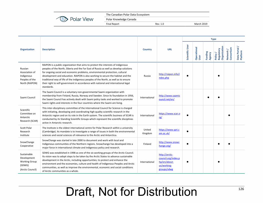
The Canadian Polar Data Ecosystem
Polar Knowledge Canada Final Report Rev. 1.0 March 2019
126
Organization Description Country URL
Type
Scie
ntifi
c U
ser
Ope
ratio
nal
Use
r
Fund
ing
Agen
cy
Polic
y /
Regu
lato
ry
Org
aniz
atio
n
Net
wor
k /
Cons
ortiu
m
Data
Por
tal /
Pl
atfo
rm
Russian Association of Indigenous Peoples of the North (RAIPON)
RAIPON is a public organization that aims to protect the interests of indigenous peoples of the North, Siberia and the Far East of Russia as well as develop solutions for ongoing social and economic problems, environmental protection, cultural development and education. RAIPON is also working to secure the habitat and the traditional way of life of the indigenous peoples of the North, as well as to ensure their right to self-government in accordance with national and international legal standards.
Russia http://raipon.info/index.php
Saami Council
The Saami Council is a voluntary non-governmental Saami organization with membership from Finland, Russia, Norway and Sweden. Since its foundation in 1956, the Saami Council has actively dealt with Saami policy tasks and worked to promote Saami rights and interests in the four countries where the Saami are living.
International http://www.saamicouncil.net/en/
Scientific Committee on Antarctic Research (SCAR)
This inter-disciplinary committee of the International Council for Science is charged with initiating, developing and coordinating high quality scientific research in the Antarctic region and on its role in the Earth system. The scientific business of SCAR is conducted by its Standing Scientific Groups which represent the scientific disciplines active in Antarctic research.
International https://www.scar.org/
Scott Polar Research Institute
The Institute is the oldest international centre for Polar Research within a university (Cambridge). Its mandate is to investigate a range of issues in both the environmental sciences and social sciences of relevance to the Arctic and Antarctica.
United Kingdom
https://www.spri.cam.ac.uk/
SnowChange Cooperative
SnowChange was started in late 2000 to document and work with local and Indigenous communities of the Northern regions. Snowchange has developed into a major force in international climate and indigenous policy and research.
Finland http://www.snowchange.org/
Sustainable Development Working Group (SDWG)
(Arctic Council)
SDWG was established in 1998 as one of the six working groups of the Arctic Council. Its vision was to adopt steps to be taken by the Arctic States to advance sustainable development in the Arctic, including opportunities; to protect and enhance the environment and the economies, culture and health of Indigenous Peoples and Arctic communities, as well as improve the environmental, economic and social conditions of Arctic communities as a whole.
International
http://arctic-council.org/index.php/en/about-us/working-groups/sdwg
Draft, Not for Distribution

The Canadian Polar Data Ecosystem
Polar Knowledge Canada Final Report Rev. 1.0 March 2019
127
Organization Description Country URL
Type
Scie
ntifi
c U
ser
Ope
ratio
nal
Use
r
Fund
ing
Agen
cy
Polic
y /
Regu
lato
ry
Org
aniz
atio
n
Net
wor
k /
Cons
ortiu
m
Data
Por
tal /
Pl
atfo
rm
Sustaining Arctic Observing Networks –(SAON)
(Arctic Council)
The organization’s initiating group, composed of international organizations, agencies and northern residents involved in research, operational and local observing, was formed in 2007. SAON's aim is to develop a set of recommendations on how to achieve long-term Arctic-wide observing activities that provide free, open, and timely access to high-quality data that will realize pan-Arctic and global value-added services and provide societal benefits.
International https://www.arcticobserving.org/
Svalbard Integrated Arctic Observing System (SIOS)
SIOS is a regional observing system for long-term measurements in and around Svalbard addressing Earth System Science questions. SIOS integrates the existing distributed observational infrastructure and generates added value for all partners beyond what their individual capacities can provide. The search interface was updated November 2017 and is now harvesting and testing data from contributing repositories. The current version of the search interface connects to remote datasets using OPeNDAP where possible to determine the feature type (e.g., time series, grid, trajectory, etc.) while doing the search.
Norway https://sios-svalbard.org
Sweden Oden Mapping Data – Bolin Centre Database
The Bolin Centre is a multi-disciplinary consortium of over 300 scientists in Sweden that conduct research and graduate education related to the Earth´s climate. The Centre manages numerous databases of scientific information, of which one is the Oden Mapping database which is a repository for mapping data retrieved by Icebreaker Oden available for download.
Sweden https://oden.geo.su.se
Swedish Meteorological and Hydrological Institute (SMHI)
SMHI is an expert agency under the Swedish Ministry of the Environment and Energy. Through unique expertise in meteorology, hydrology, oceanography and climatology, it offers many services that contribute to increased safety and a sustainable society.
Sweden https://www.smhi.se/en
Swedish Polar Research Secretariat
A government agency that promotes and co-ordinates Swedish polar research, the Secretariat's mission is to both plan and complete research and development, as well as organise and lead research expeditions to the Arctic and Antarctic regions.
Sweden https://polar.se/en/
Draft, Not for Distribution

The Canadian Polar Data Ecosystem
Polar Knowledge Canada Final Report Rev. 1.0 March 2019
128
Organization Description Country URL
Type
Scie
ntifi
c U
ser
Ope
ratio
nal
Use
r
Fund
ing
Agen
cy
Polic
y /
Regu
lato
ry
Org
aniz
atio
n
Net
wor
k /
Cons
ortiu
m
Data
Por
tal /
Pl
atfo
rm
Swiss Committee on Polar and High Altitude Research
The Swiss Committee on Polar and High Altitude Research is a committee of the Swiss Academies of Arts and Sciences and the Platform Science and Policy of the Swiss Academy of Natural Sciences (SCNAT). The committee’s main objectives are to provide the legal body to represent Switzerland in international committees on polar and high altitude research such as the Scientific Committee on Antarctic Research (SCAR) and the International Arctic Science Committee (IASC). Furthermore, the committee plays an active role in early recognition of research needs and issues in the thematic fields such as climate change, ice and snow climate models, etc.
Switzerland http://www.polar-research.ch/e/index.php
SYKE – Finnish Environmental Institute
SYKE’s research and expertise support the protection and use of the sensitive environments in the Arctic regions. SYKE is extensively involved in the Arctic Council's work and in various projects in northern areas. They act in the Arctic region with the aim of resolving various environmental problems, the most significant of these are climate change and environmental toxicants. They also carry out regular research of the Arctic marine environment.
Finland http://www.syke.fi/en-US
Tekes – Finnish Funding Agency for Innovation
Tekes is the main government financing and expert organization for research and technological development in Finland. Tekes finances company R&D projects as well as projects in universities and research institutes. Tekes funding incentives and Tekes programmes have had a significant impact on the innovation cooperation between companies and research organisations.
Finland https://www.businessfinland.fi/en/
The Alfred Wegener Institute (AWI)
Established as a public foundation in 1980, the institute is a member of the Association of German Research Centres. AWI's research mission is to improve our understanding of ocean-ice-atmosphere interactions, the animal and plant kingdoms of the Arctic and Antarctic, and the evolution of the polar continents and seas.
German https://www.awi.de/en.html
The Arctic Portal
The Arctic Portal is a comprehensive gateway to Arctic information and data on the Internet, increasing information sharing and co-operation among Arctic stakeholders and granting exposure to Arctic related information and data. The Arctic Portal is managed as non-profitable organization, located in Akureyri, Iceland, under an international board of directors. It is operated in consultation and co-operation with members of the Arctic Council and its Working Groups, Permanent Participants, Observers and other Stakeholders.
Iceland https://arcticportal.org/
Draft, Not for Distribution
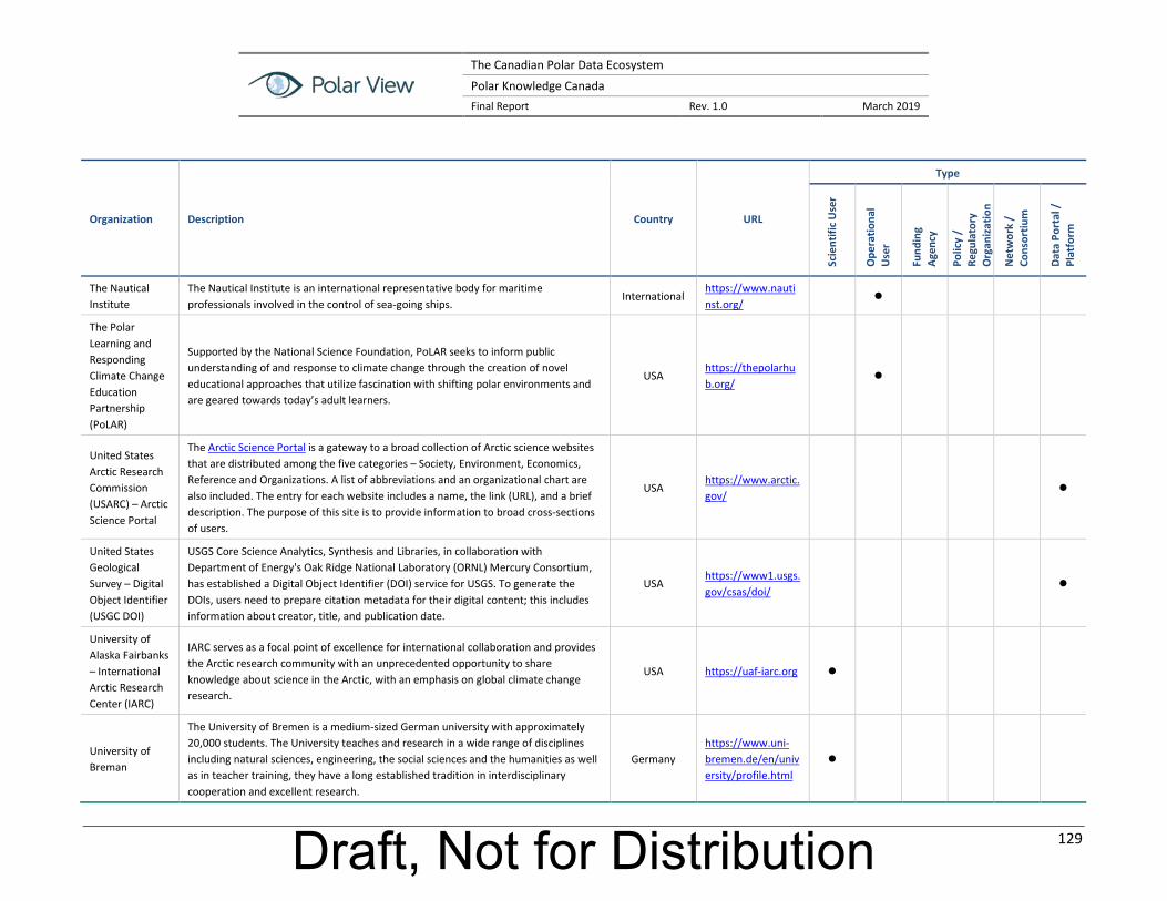
The Canadian Polar Data Ecosystem
Polar Knowledge Canada Final Report Rev. 1.0 March 2019
129
Organization Description Country URL
Type
Scie
ntifi
c U
ser
Ope
ratio
nal
Use
r
Fund
ing
Agen
cy
Polic
y /
Regu
lato
ry
Org
aniz
atio
n
Net
wor
k /
Cons
ortiu
m
Data
Por
tal /
Pl
atfo
rm
The Nautical Institute
The Nautical Institute is an international representative body for maritime professionals involved in the control of sea-going ships.
International https://www.nautinst.org/
The Polar Learning and Responding Climate Change Education Partnership (PoLAR)
Supported by the National Science Foundation, PoLAR seeks to inform public understanding of and response to climate change through the creation of novel educational approaches that utilize fascination with shifting polar environments and are geared towards today’s adult learners.
USA https://thepolarhub.org/
United States Arctic Research Commission (USARC) – Arctic Science Portal
The Arctic Science Portal is a gateway to a broad collection of Arctic science websites that are distributed among the five categories – Society, Environment, Economics, Reference and Organizations. A list of abbreviations and an organizational chart are also included. The entry for each website includes a name, the link (URL), and a brief description. The purpose of this site is to provide information to broad cross-sections of users.
USA https://www.arctic.gov/
United States Geological Survey – Digital Object Identifier (USGC DOI)
USGS Core Science Analytics, Synthesis and Libraries, in collaboration with Department of Energy's Oak Ridge National Laboratory (ORNL) Mercury Consortium, has established a Digital Object Identifier (DOI) service for USGS. To generate the DOIs, users need to prepare citation metadata for their digital content; this includes information about creator, title, and publication date.
USA https://www1.usgs.gov/csas/doi/
University of Alaska Fairbanks – International Arctic Research Center (IARC)
IARC serves as a focal point of excellence for international collaboration and provides the Arctic research community with an unprecedented opportunity to share knowledge about science in the Arctic, with an emphasis on global climate change research.
USA https://uaf-iarc.org
University of Breman
The University of Bremen is a medium-sized German university with approximately 20,000 students. The University teaches and research in a wide range of disciplines including natural sciences, engineering, the social sciences and the humanities as well as in teacher training, they have a long established tradition in interdisciplinary cooperation and excellent research.
Germany https://www.uni-bremen.de/en/university/profile.html
Draft, Not for Distribution

The Canadian Polar Data Ecosystem
Polar Knowledge Canada Final Report Rev. 1.0 March 2019
130
Organization Description Country URL
Type
Scie
ntifi
c U
ser
Ope
ratio
nal
Use
r
Fund
ing
Agen
cy
Polic
y /
Regu
lato
ry
Org
aniz
atio
n
Net
wor
k /
Cons
ortiu
m
Data
Por
tal /
Pl
atfo
rm
University of Calgary – Arctic Institute of North America
The Arctic Institute of North America was created by a Canadian Act of Parliament in 1945 as a non-profit research and educational organization. Originally based at McGill University in Montreal, the institute moved to the University of Calgary in 1976. Its mandate is to advance the study of the North American and circumpolar Arctic through the natural and social sciences, the arts and humanities and to acquire, preserve and disseminate information on physical, environmental and social conditions in the North.
Canada http://arctic.ucalgary.ca/
University of Calgary – Arctic Science and Technology Information System (ASTIS)
The ASTIS database contains over 80,000 records describing publications and research projects about northern Canada. ASTIS, a project of the Arctic Institute of North America at the University of Calgary, also maintains subset databases about specific regions, subjects and projects.
Canada http://www.aina.ucalgary.ca/astis/
University of Calgary – ArcticConnect
ArcticConnect is a network-enabled platform for realizing geospatial referencing of information about the arctic system derived from research, education and private sector activities in the arctic and subarctic.
Canada http://arcticconnect.org/arcticconnect
University of Leeds – Changing Arctic Oceans (ChAOS)
ChAOS will provide fundamental data and quantify the effects of changing sea ice cover on the resulting ecosystem function on the Arctic seafloor, which will contribute to improving the predictive capacity of the numerical models. The University of Leeds is a key funding and research partner.
United Kingdom
https://www.changing-arctic-ocean.ac.uk/project/chaos/
University of Manitoba- Centre of Earth Observation Sciences (CEOS)
CEOS was established in 1994 with a mandate to research, preserve and communicate knowledge of Earth system processes using the technologies of Earth Observation Science. Research is multidisciplinary and collaborative seeking to understand the complex interrelationships between elements of Earth systems, and how these systems will likely respond to climate change. Although researchers have worked in many regions, the Arctic marine system has always been a key focus of activity.
Canada http://umanitoba.ca/ceos/
University of the Arctic
The University is a cooperative network of universities, colleges, research institutes and other organizations concerned with education and research in and about the North. It builds and strengthens collective resources and collaborative infrastructure that enables member institutions to better serve their constituents and their regions.
International https://www.uarctic.org/
Draft, Not for Distribution

The Canadian Polar Data Ecosystem
Polar Knowledge Canada Final Report Rev. 1.0 March 2019
131
Organization Description Country URL
Type
Scie
ntifi
c U
ser
Ope
ratio
nal
Use
r
Fund
ing
Agen
cy
Polic
y /
Regu
lato
ry
Org
aniz
atio
n
Net
wor
k /
Cons
ortiu
m
Data
Por
tal /
Pl
atfo
rm
VTT Technical Research Centre of Finland
VTT Technical Research Centre of Finland Ltd is one of the leading research and technology organizations in Europe. Their research and innovation services give partners, both private and public, all over the world a competitive edge. In particular, they have expertise on extreme harsh and demanding cold climate environments. They work in the area of sustainable and safe solutions for offshore, marine, coastal and infra structures and operations in harsh and demanding cold climate environments.
Finland http://www.vttresearch.com/
Word Ocean Council
(WOC)
WOC is an international, cross-sectoral industry leadership alliance interested in “corporate ocean responsibility”. It brings together the diverse ocean business community to collaborate on stewardship of the seas. This unique coalition is working to improve ocean science in support of safe and sustainable operations, educate the public and stakeholders about the role of responsible companies in addressing environmental concerns, more effectively engaging in ocean policy and planning, and developing science-based solutions to cross-cutting environmental challenges.
International https://www.oceancouncil.org/
World Climate Research Program
(WCRP)
WCRP facilitates analysis and prediction of Earth system change for use in a range of practical applications of direct relevance, benefit and value to society. WCRP aims to determine the predictability of climate and the effect of human activities on climate. One of its core programs is Climate and Cryosphere (CliC): CliC encourages and promotes research into the cryosphere in order to improve understanding of the cryosphere and its interactions with the global climate system, and to enhance the ability to use parts of the cryosphere for detection of climate change. The WCRP Data Advisory Council (WDAC) acts as a focal point for all WCRP data, information, and observation activities with its sister programmes, and coordinates their high-level aspects across WCRP, ensuring cooperation with main partners such as GCOS and other observing programmes.
International https://www.wcrp-climate.org/
Draft, Not for Distribution

The Canadian Polar Data Ecosystem
Polar Knowledge Canada Final Report Rev. 1.0 March 2019
132
Organization Description Country URL
Type
Scie
ntifi
c U
ser
Ope
ratio
nal
Use
r
Fund
ing
Agen
cy
Polic
y /
Regu
lato
ry
Org
aniz
atio
n
Net
wor
k /
Cons
ortiu
m
Data
Por
tal /
Pl
atfo
rm
World Meteorological Organization Information System (WIS)
WIS is the single coordinated global infrastructure responsible for the WMO telecommunications and data management functions. It is the pillar of the WMO strategy for managing and moving weather, climate and water information in the 21st century. WIS provides an integrated approach suitable for all WMO Programmes to meet the requirements for routine collection and automated dissemination of observed data and products, as well as data discovery, access and retrieval services for all weather, climate, water and related data produced by centres and Member countries in the framework of any WMO Programme.
International http://www.wmo.int/pages/prog/www/WIS/
World Shipping Council (WSC)
The goal of WSC is to provide a coordinated voice for the liner shipping industry. WSC and its member companies partner with governments and other stakeholders to collaborate on actionable solutions for some of the world's most challenging transportation problems.
International http://www.worldshipping.org/
World Weather Watch -
World Meteorological Organization (WMO)
To predict the weather, modern meteorology depends upon near instantaneous exchange of weather information across the globe. Established in 1963, the World Weather Watch – the core of the WMO Programmes – combines observing systems, telecommunication facilities, and data-processing and forecasting centres – operated by Members – to make available meteorological and related environmental information needed to provide efficient services in all countries: Global Observing System (GOS), Global Telecommunication System, Global Data-Processing and Forecasting System.
International http://www.wmo.int/pages/prog/www/index_en.html
World Wildlife Fund (WWF) -Global Arctic Programme
WWF-Canada is planning for an Arctic future that conserves wildlife while respecting the practices and traditions of local communities, and promoting the responsible development of Arctic resources. WWF does this through its Global Arctic Programme. This programme sponsors scientific research, by working with communities, industry, Indigenous groups and government, by empowering young people to speak out for the Arctic, and by furthering national and international efforts to reduce greenhouse gas emissions and slow rapid climate change.
International http://www.wwf.ca/conservation/arctic/whatwwfisdoing/
Draft, Not for Distribution