the canadian malartic mine, southern abitibi belt, quebec, canada
TRANSCRIPT
The Canadian Malartic Mine, Southern Abitibi Belt, Quebec,
Canada: Discovery and Development of an Archean Bulk-
Tonnage Gold Deposit.
Robert Wares, P. Geo., Executive Vice-President, Exploration and Resource
Development, Osisko Mining Corporation and John Burzynski, Vice-President
Corporate Development, Osisko Mining Corporation
Osisko Mining Corporation, 1100 Ave. des Canadiens, Suite 300, Montreal
Province of Quebec, Canada H3B 2S2
Contact person: Robert Wares, Osisko Mining Corporation ([email protected])
Abstract
Osisko Mining Corporation‟s Canadian Malartic Mine is located immediately south of the prolific Cadillac-Larder Lake fault zone in the Archean Southern Abitibi greenstone belt, host to over one hundred million ounces of gold production since the 1920‟s. The Canadian Malartic project began in October 2004 with the acquisition, from the McWatters Mines bankruptcy trustee, of the initial claim block covering the site of the old underground Canadian Malartic gold mine, which produced approximately one million ounces of gold from 1935 to 1965. At the time the site was regarded by most companies as little more than an exhausted brownfield mining camp requiring environmental remediation.
In 2004, Osisko Exploration Ltd. was a junior exploration company with only three full-time employees and a market capitalization of under $5 million. The key component to the success of the company was an innovative strategy: to discover and delineate a high-tonnage, low-grade gold deposit amenable to open pit mining, based on an unusual geological model for the Abitibi region, i.e. that of an Archean porphyry gold deposit. Starting in early 2004, Osisko focussed its efforts on the Quebec portion of the Archean Superior province. Targeted compilation of publicly available data, mostly extracted from the Quebec government‟s online geoscientific database (SIGEOM™), was fine-tuned to the characteristics of porphyry gold systems and this research highlighted the site of the old Canadian Malartic mine as a high priority target. The acquisition of the initial claim block was accompanied by a large, unpublished paper database from the historic Canadian Malartic mining operations as well as from later exploration programs carried out on the property, particularly from the 1980‟s when Lac Minerals attempted to define small, near surface open-pit resources on the property. Digitalisation, compilation and analysis of the large database over the following four months, including logs of over 4500 surface and underground drill holes, allowed Osisko to refine the geological model for the property and confirm its bulk tonnage potential.
Initiating this project was a challenging decision, for even if the exploration and resource definition phases were to succeed, the subsequent construction and operation of an open-pit mine adjacent to the town of Malartic would require the resettlement of the entire southern part of the town. The project therefore began with much scepticism in the Abitibi mining community, both for economic and social reasons.
Seven years following the initial property acquisition, after over 750,000 metres of drilling, the filing of a positive feasibility study in November 2008, government approval of the project in August 2009 and successful financing of the CAN $1 billion project, the construction and start-up of the Canadian Malartic open pit gold mine has been completed. Commercial production at 60% of capacity was achieved in May 2011 and ramp-up to full production capacity of 60,000 tonnes per day should be achieved by the end of the second quarter of 2012, allowing for an annual production of 500,000 to 750,000 ounces of gold and making this one of Canada‟s largest gold mines. Total proven and probable reserves (at US$1200 gold) currently stand at 10.7 million ounces gold (343.7 Mt @ 0.97 g/t Au) contained within a larger in situ Measured & Indicated Nl 43-101 compliant resource of 11.80 million ounces gold (352.7 Mt @ 1.04 g/t Au), making this a world-class gold deposit.
The Canadian Malartic story is an excellent example of how the application of modern empirical ore deposit models to previously mined areas, even using old databases, can achieve success and lead to world class discoveries.

Introduction
Osisko Mining Corporation has been actively exploring and developing its wholly-owned Canadian Malartic project since March 2005, following the acquisition of the initial mining titles of the property in October 2004. Seven years after the initial property acquisition, after over 750,000 metres of drilling, the filing of a positive feasibility study in November 2008, government approval of the project in August 2009 and successful financing of the CAN $1 billion project, the construction and start-up of the Canadian Malartic open pit gold mine are completed. Commercial production at 60% of capacity was achieved in May 2011 and ramp-up to full production capacity of 60,000 tonnes per day should be achieved by the end of the second quarter of 2012, allowing for an annual production of 500,000 to 750,000 ounces of gold and making this one of Canada‟s largest gold mines. Total proven and probable reserves (at US$1200 gold) currently stand at 10.7 million ounces gold (343.7 Mt @ 0.97 g/t Au) contained within a larger in situ Measured & Indicated Nl 43-101 compliant resource of 11.80 million ounces gold (352.7 Mt @ 1.04 g/t Au), making this a world-class gold deposit.
The project currently consists of 119 contiguous mineral exploration or mining titles totalling 5,404 hectares. The project is located in the heart of the Abitibi Gold Belt of northwestern Québec (Figure 1). It lies immediately adjacent to the town of Malartic, about 25 km west of Val d‟Or and about 550
km northwest of Montreal, Québec. Malartic is accessed by paved highway from either Rouyn-Noranda or Val d‟Or, both of which can be reached by daily commercial flights.
Details of the exploration strategy and criteria that led to the discovery of the deposit are outlined in this paper. This case study is an excellent example of how the application of modern empirical ore deposit models to previously mined areas, even using old databases, can achieve success and lead to world class discoveries.
Canadian Malartic Exploration and Production History
Gold was first discovered in the Malartic area in 1923 by the Gouldie Brothers at what is now designated the Gouldie Zone, a small deposit located immediately south of the Canadian Malartic deposit (Figure 2, Trudel et Sauvé, 1992). In 1925, a new showing at the site of the current mine was discovered and staked by an Ottawa-based prospecting syndicate, located about 1.6 km northwest of the Gouldie prospect. This property was sold to the newly-incorporated Malartic Gold Mines in 1927. Malartic Gold Mines undertook drilling, trenching and limited underground development on the deposit until 1929, when the project was suspended with the onset of the Great Depression.
In 1933, the Canadian Malartic Gold Mines Company took possession of the Malartic Mines property as well as the claims covering the Gouldie prospect and developed a new mine. Production at the Canadian Malartic Mine began in 1935 and continued uninterrupted until 1965. The deposit was mined mostly by underground long-hole stoping methods, making it the only underground bulk tonnage gold mine in Québec at the time. Mining was limited to higher grade (greater than 3 g/t Au) mineralized zones occurring within a larger, lower grade mineralized envelope, along nine levels extending to a depth of approximately 350 m. A total of 9,931,376 tonnes of ore at an average grade of 3.37 g/t Au were extracted, for an aggregate production of 33,468.3 kg of gold (1.08 M oz Au). In 1964, Falconbridge Nickel Ltd. purchased the Canadian Malartic Mine and, following cessation of gold production in 1965, refurbished the mill to process nickel ore from its Marbridge Mine. These operations ceased in 1968, after which the Canadian Malartic mill was decommissioned and removed.
The Canadian Malartic success prompted additional exploration, discovery and development immediately to the north and east. The resulting Malartic gold camp included four past-producing gold mines, three of which (Canadian Malartic, Sladen and East Malartic Mines) were portions of a 4,000 m-long, continuous mineralized system, exploited from west to east respectively. During the period

Figure 1. Regional geology of Quebec’s southern Abitibi greenstone belt, including location of the Canadian
Malartic deposit.
from 1935 to 1979, these mines produced a total of 159,451 kg (5.13 M oz) of gold, mostly from underground operations. The detailed historical production figures are reported in Grant et al. (1987), Sansfaçon et al. (1986) and Trudel and Sauvé (1992). The Sladen Mine, which mined the eastern extension of the Canadian Malartic deposit, went into production in 1938. Other small gold deposits immediately to the north were developed and mined at the same time by Barnat Mines Ltd., and as production waned at the Sladen in 1948, Barnat Mines Ltd. purchased Sladen Mines Ltd. as well as other ground to the north owned by National Malartic Mines Ltd. The merged Barnat/Sladen mines continued operating in the area under Barnat Mines Ltd. until 1970, although the Sladen ore zone had been exhausted by 1951. Lake Shore Mines Ltd. purchased the Barnat/Sladen mine in 1970 and re-opened the mine in 1976, operating it until 1979. The East Malartic Mine independently went into production in 1938 and continued with only minor interruptions until 1979. In 1974, the mining titles covering a portion of the historic Canadian Malartic holdings were purchased by East Malartic Mines.
Following cessation of mining in 1979, the entire Malartic gold camp, covering the balance of the Canadian Malartic ground, as well as the past-producing Barnat/Sladen and East Malartic Mines, was acquired by Long Lac Exploration Ltd. Relatively little exploration work was done before development began on the mines and, during mining operations, essentially all reports of geological work, drilling,
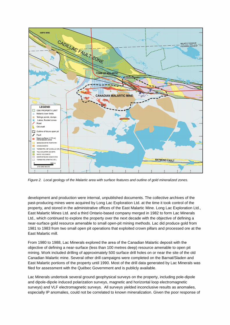
Figure 2. Local geology of the Malartic area with surface features and outline of gold mineralized zones.
development and production were internal, unpublished documents. The collective archives of the past-producing mines were acquired by Long Lac Exploration Ltd. at the time it took control of the property, and stored in the administrative offices of the East Malartic Mine. Long Lac Exploration Ltd., East Malartic Mines Ltd. and a third Ontario-based company merged in 1982 to form Lac Minerals Ltd., which continued to explore the property over the next decade with the objective of defining a near-surface gold resource amenable to small open-pit mining methods. Lac did produce gold from 1981 to 1983 from two small open pit operations that exploited crown pillars and processed ore at the East Malartic mill.
From 1980 to 1988, Lac Minerals explored the area of the Canadian Malartic deposit with the objective of defining a near-surface (less than 100 metres deep) resource amenable to open pit mining. Work included drilling of approximately 500 surface drill holes on or near the site of the old Canadian Malartic mine. Several other drill campaigns were completed on the Barnat/Sladen and East Malartic portions of the property until 1990. Most of the drill data generated by Lac Minerals was filed for assessment with the Québec Government and is publicly available.
Lac Minerals undertook several ground geophysical surveys on the property, including pole-dipole and dipole-dipole induced polarization surveys, magnetic and horizontal loop electromagnetic surveys) and VLF electromagnetic surveys. All surveys yielded inconclusive results as anomalies, especially IP anomalies, could not be correlated to known mineralization. Given the poor response of
the various geophysical survey techniques, Lac Minerals targeted its exploration drilling program based on results of historic drilling, underground development and surface geological mapping.
The exploration program led to the definition of five near-surface gold mineralized zones forming an aggregate unclassified resource (pre-NI 43-101) of approximately 8,160,000 tonnes with an average grade of 1.98 g/t Au (520,000 oz Au), using a cut-off grade of 1.03 g/t Au. Unbeknownst to Lac Minerals, the mineralized zones they defined were all the near-surface expression of a much larger, lower-grade, continuously mineralized gold system extending to a depth of at least 400 m.
Lac Minerals estimated in 1989 an unclassified (pre-NI 43-101) resource of 27,210,000 metric tonnes with an average grade of 1.95 g/t Au (1,706,100 oz Au) at the Canadian Malartic deposit to a vertical depth of 305 m. This figure was calculated using a cut-off grade of 1.03 g/t Au/t but gold prices at the time did not allow, according to Lac Minerals, open pit mining to depths of greater than 100 metres.
As Lac Minerals completed a feasibility study on the project, control of the property fell to Barrick Gold Corp. in 1994 when it acquired Lac Minerals. Barrick did not explore the property but completed a number of environmental and stope stability studies during the 1990‟s. Barrick‟s principal activity in the area was to process ore from its Bousquet Mine at the East Malartic mill, which lasted until 2002. Barrick sold all of its interests in the Malartic camp in February 2003.
During the time Barrick owned the property (1994 - 2003), no exploration work was done. Efforts focused on partial recompilation of historical data for resource estimate purposes, and on stope stability and environmental assessment. Barrick drilled a limited number of geotechnical holes to determine the thickness and stability of crown pillars of the Canadian Malartic Mine, in the area underlying houses in the southern part of the town of Malartic. After the 2003 acquisition, there is no public record of McWatters performing any exploration work on the property.
Regional Geology
The first geological maps of the Malartic area (Fournière Township) were produced in 1925 by the Geological Survey of Canada and by Quebec Mines Service geologist O‟Neill (1935), who remapped the Canadian Malartic property at a detailed scale and provided the first petrographic descriptions of the mineralized rocks. Derry (1939) and Derry and Herz (1948) published papers detailing the structure, alteration as well as a metallogenic model for the Canadian Malartic gold deposit. Geological reports on the Malartic gold camp have been published by Gunning and Ambrose (1940), Eakins (1962), Sansfaçon (1986), Grant et al. (1987), Sansfaçon and Hubert (1990), Trudel and Sauvé (1992) and Fallara et al. (2000).
The Malartic property straddles the southern margin of the eastern portion of the Abitibi Subprovince, an Archean greenstone belt situated in the southeastern part of the Superior Province of the Canadian Shield. The Abitibi Subprovince is comprised of an older northern volcanic zone (2730 - 2710 MA) and a younger southern volcanic zone (2705 - 2698 Ma), separated by the regional Porcupine-Destor Fault Zone (Card and Poulsen (1998). The Abitibi Subprovince is limited to the north by gneisses and plutons of the Opatica Subprovince, and to the south by metasediments and intrusive rocks of the Pontiac Subprovince. The contact between the Pontiac Subprovince and the rocks of the Abitibi greenstone belt is characterized by a major fault corridor, the east-west trending Cadillac-Larder Lake Fault Zone (Figure 1). This prolific gold-bearing structure runs from Matachewan through the Kirkland Lake and the Larder Lake gold camps on the Ontario side, through the Rouyn-Noranda, Cadillac, Malartic and Val d‟Or gold camps on the Quebec side, after which it is truncated further east by the Grenville Front. The corridor defined by the Porcupine-Destor Fault Zone and the Cadillac-Larder Lake Fault Zone, generally known as the Timmins-Val d'Or camp (Robert et al. (2005), hosts a great number of mineral deposits that account for the bulk of historical and current base and precious metal production from the Superior province (Spooner and Tucker-Barrie (1993).

The regional stratigraphy of the southeastern Abitibi area is divided into groups of alternating volcanic and clastic sedimentary rocks, generally oriented at N280° to N330° and separated by faults zones. The main lithostratigraphic divisions in this region are, from south to north, the Pontiac Group of the Pontiac Subprovince and the Piché, Cadillac, Blake River, Kewagama and Malartic Groups of the Abitibi Subprovince. The Pontiac group includes greywackes, shales and minor conglomerates (turbiditic clastic sediments), as well as thin horizons of ultramafic volcanic rocks. The Piché group, confined within the Cadillac Fault Zone, comprises abundant talc-chlorite-carbonate schists representing strongly deformed and altered magnesian basaltic to komatiitic volcanics. The schists include abundant irregular, deformed intrusions of diorite and feldspar porphyry, many of which are gold-mineralized. The Cadillac Group consists of greywackes and polymictic conglomerates; the Blake River Group is dominated by basalts; the Kewagama Group includes greywacke, shales, oxide-facies iron formation and conglomerates and the Malartic group comprises ultramafic volcanic rocks.
The various lithological groups within the Abitibi Subprovince are metamorphosed to greenschist facies. Metamorphic grade increases toward the southern limit of the Abitibi belt, where rocks of the Piché Group and the northern part of the Pontiac Group have been metamorphosed to upper greenschist facies. The latter rocks have been subject to retrograde metamorphism, probably due to hydrothermal flux associated with the Cadillac Fault, as evidenced by chloritization of biotite, development of actinolite after hornblende and albitization of more calcic plagioclase. Metamorphism increases rapidly to the south of the Cadillac Fault Zone within the Pontiac Group. The sediments at the southern end of the Canadian Malartic property are metamorphosed to staurolite-facies paraschists and into migmatitic gneisses further south. This higher grade metamorphic terrane is also punctuated by frequent peraluminous granite intrusions, derived from partial melting of the metasediments during orogenesis.
The majority of the Canadian Malartic property is underlain by meta-sedimentary units of the Pontiac Group, lying immediately south of the Cadillac Fault Zone (Figure 2). The north-central portion of the property covers an approximately 3.5 km-long section of the Cadillac fault corridor and is underlain by mafic-ultramafic metavolcanic rocks of the Piché Group cut by abundant porphyritic intrusions, as well as metasediments of the Cadillac Group to the north of the fault zone. At the point where the Cadillac Tectonic Zone transects the town of Malartic, it is oriented N320°E, whereas further east it is oriented at N280°E - N290°E. The rapid change in the direction of the fault corridor has been interpreted by Gunning and Ambrose (1940) and Eakins (1962) as a bifurcation of the fault zone. The portion of the fault zone oriented N280°E - N290°E has been locally referred to as the Malartic Fault Zone; it extends about 9 km along strike with a width of 600 to 900 m. The Malartic Fault Zone includes many subordinate faults with orientations varying from sub-vertical to sub-horizontal. The portion of the Piché Group volcanic belt that transects the Canadian Malartic property is about 650 m wide. Two major structures, the Malartic (Cadillac) and Sladen faults, define the northern and southern boundaries of the tectonic zone in the immediate Malartic area. As it occurs on the property, the Malartic fault is oriented N260°E - N280°E and dips 75° to the north, whereas the Sladen fault is oriented N090°E - N100°E and dips variably from 70°S to sub-vertical. The Piché Group ultramafic metavolcanic rocks outcrop very poorly on the property, and are known from historic records, underground workings and exposure in the Buckshot open pit. The Piché Group rocks are typically bluish-grey, pervasively foliated with numerous veinlets of talc-carbonate. Less altered variants occur as massive, aphanitic to fine grained serpentinized ultramafic rock.
The Pontiac Group metasediments on the property comprise turbiditic greywacke, mudstone and minor siltstone, generally rhythmically banded with beds of variable thickness ranging from about one centimetre to one metre. The sediments typically have a well-developed foliation and are dark grey to black, occasionally exhibiting a brownish tint caused by development of biotite through metamorphism and/or potassic alteration proximal to porphyritic felsic intrusions.

The rocks of the Pontiac and Piché Groups are intruded by a number of epizonal felsic porphyritic bodies, variously described as syenites, quartz syenites, quartz monzonites, granodiorites and tonalities. The geometries of these felsic intrusions are highly variable, and occur on the property as sills, dykes, discontinuous lenses or small isolated stocks.
The porphyries are all feldspar-phyric (1 to 5 mm wide phenocrysts) with fine-grained to aphanitic, medium to light grey matrices. Within the Pontiac Group, the porphyritic intrusions are particularly abundant within an area bounded to the south by the Raymond Fault. South of the Raymond Fault, a swarm of ultramafic sills (possibly komatiitic flows) occur in the metasediments in the south-western portion of the Canadian Malartic property. The Fournière granodiorite/tonalite pluton touches the southeastern extremity of the property.
Mineralization and Deposit Geology
Mineralization in the Canadian Malartic deposit occurs as a semi- continuous shell of 1 to 3% disseminated pyrite that encloses fine native gold as rounded inclusions with an average of 15 microns diameter. The pyrite is associated with traces of chalcopyrite, sphalerite, molybdenite and gold-silver and silver tellurides (Eakins (1962), Fallara et al. (2000)). The ore from the old Canadian Malartic Mine was anomalously rich in silver relative to the rest of the Malartic gold camp and other mesothermal vein deposits along the Cadillac Fault Zone, with gold to silver ratios ranging from about 4:1 to 1:1, due to the relative abundance of silver tellurides in associated with the gold mineralization.
The gold resource is mostly hosted by altered clastic sediments of the Pontiac Group (70%) overlying an epizonal monzodioritic porphyry intrusion. A portion of the deposit also occurs in the upper portions of the porphyry body (30%) underlying the host metasediments. The porphyry intrusion pinches out in the eastern portion of the deposit and disseminated mineralization continues in the strongly altered metasdiments, forming a subvertical tabular body (Sladen Extension) that is truncated by the Cadillac fault where it intersects the western extremity of the old East Malartic Mine. This truncated portion of the deposit, along with additional mineralization within the Piché Group rocks north of the fault, is called the South Barnat Zone of the current Canadian Malartic Mine.
The semi-continuous shells of higher grade mineralization (> 1 g Au/t) at Canadian Malartic define an open synformal structure trending N110°E and plunging about N20° to the ESE (Figure 3). This structure closes at the western end of the deposit and has been previously interpreted as a post-mineralization fold structure that has deformed the deposit ((Derry (1939), Derry and Herz (1948), Fallara et al (2000)). Despite the plunging synformal shape of the deposit, open pit operations since the spring of 2011 at Canadian Malartic have exposed the upper portions of the deposit and revealed little evidence for folded beds and a true synform. Clastic sedimentary beds are consistently subvertical in the deposit and commonly truncated subparallel to the bedding and penetrative schistosity, and subvertical mineralized porphyry dykes are commonly boudinaged. This suggests a deformational style dominated by flexural slip and high-angle thrusting rather than folding, hence the morphology of the deposit is currently unexplained.
For most of the strike length of the Canadian Malartic deposit, mineralization along the northern limb of the synform follows the porphyry-sediment contact. The structure becomes tabular with a steep dip to the south where the porphyry dyke pinches out in the Sladen extension. This extension of the deposit to the east presumably represents the northern limb of the synform. Northerly-dipping branches to the main deposit along the southern limb of the fold are structurally connected to a number of near-surface, sub-horizontal mineralized zones. A broad, sporadically shell of lower-grade mineralization (0.3 to 1.0 g/t Au) forms a poorly defined halo around the main deposit and is associated with a broad zone of strong potassic alteration.
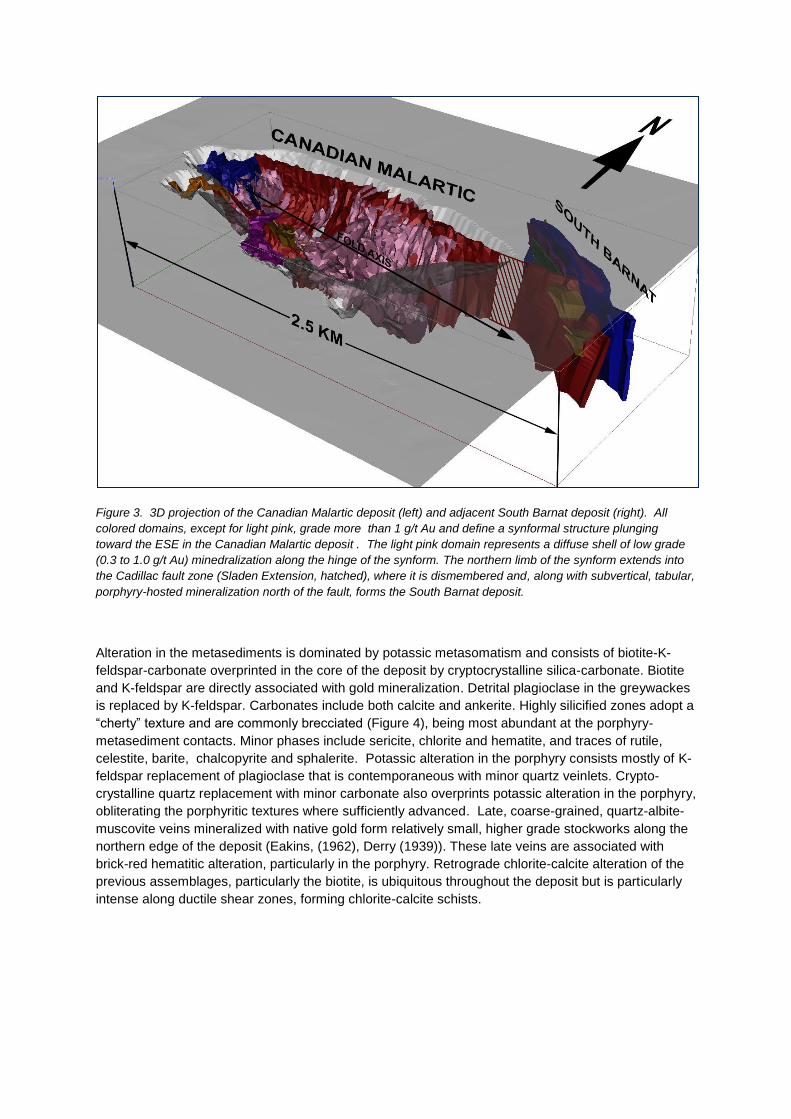
Figure 3. 3D projection of the Canadian Malartic deposit (left) and adjacent South Barnat deposit (right). All
colored domains, except for light pink, grade more than 1 g/t Au and define a synformal structure plunging
toward the ESE in the Canadian Malartic deposit . The light pink domain represents a diffuse shell of low grade
(0.3 to 1.0 g/t Au) minedralization along the hinge of the synform. The northern limb of the synform extends into
the Cadillac fault zone (Sladen Extension, hatched), where it is dismembered and, along with subvertical, tabular,
porphyry-hosted mineralization north of the fault, forms the South Barnat deposit.
Alteration in the metasediments is dominated by potassic metasomatism and consists of biotite-K-feldspar-carbonate overprinted in the core of the deposit by cryptocrystalline silica-carbonate. Biotite and K-feldspar are directly associated with gold mineralization. Detrital plagioclase in the greywackes is replaced by K-feldspar. Carbonates include both calcite and ankerite. Highly silicified zones adopt a “cherty” texture and are commonly brecciated (Figure 4), being most abundant at the porphyry-metasediment contacts. Minor phases include sericite, chlorite and hematite, and traces of rutile, celestite, barite, chalcopyrite and sphalerite. Potassic alteration in the porphyry consists mostly of K-feldspar replacement of plagioclase that is contemporaneous with minor quartz veinlets. Crypto-crystalline quartz replacement with minor carbonate also overprints potassic alteration in the porphyry, obliterating the porphyritic textures where sufficiently advanced. Late, coarse-grained, quartz-albite-muscovite veins mineralized with native gold form relatively small, higher grade stockworks along the northern edge of the deposit (Eakins, (1962), Derry (1939)). These late veins are associated with brick-red hematitic alteration, particularly in the porphyry. Retrograde chlorite-calcite alteration of the previous assemblages, particularly the biotite, is ubiquitous throughout the deposit but is particularly intense along ductile shear zones, forming chlorite-calcite schists.

Figure 4. NQ core samples showing progressive alteration in clastic metasediments of the Pontiac Group that
host the bulk of the deposit . A) Incipient potassic alteration (brownish hue due to biotite) along a fracture in
greenschist-grade greywacke, located 500 m southwest of the deposit; note flattened early authigenic pyrite in
the greywacke; B) advanced potasssic alteration of greywacke showing silicious overprint in the core of the
sample that is brecciated by late biotite-calcite veinlets; sample runs 1.30 g/t Au and shows characteristic
disseminated auriferous pyrite mineralization; C) advanced silicification (+ankerite) of greywacke that has
obliterated all primary textures and resulted in a ”cherty” aphanitic rock; this sample contains much less pyrite
than (B) but grades 1.15 g/t Au.
Exploration Strategy
Osisko was founded in 1998 by Robert Wares and was initially engaged in general exploration for precious and base metals in Quebec. Sean Roosen (currently President and CEO of Osisko) and John Burzynski (co-author of this paper) joined Osisko in the spring of 2003, injecting fresh capital from German investors into the company. The shareholders of the German holding company were convinced to proceed on the basis of strategically investing into a promising, inexpensive gold junior exploration company that was well positioned to capitalize on what was perceived to be the beginning of a long-term bull market on gold.
The new Osisko team strategically chose to focus exploration/acquisition on bulk tonnage, open pit mineable gold deposits as these deposit types characterize the majority of large, world-class gold mining operations, i.e. those with greater than 5 million ounces of reserves. From the mining side of such potential operations, popular perception in Canada at the time was such that bulk-tonnage gold

mining operations are only economical in tropical or desert environments, where oxidation of the upper portions of such deposits allowed for easier mining, grinding and/or heap leaching, significantly favouring the economics of such mines. However, a review of Kinross‟s Fort Knox mine in Alaska
convinced the Osisko team of the merits of bulk tonnage mining operations in northern climates, and the decision was made to include Canada in the definition of exploration targets.
Following exploration programs at several unsuccessful projects in Quebec and Brazil, the group encouraged the first author to focus target generation efforts on the Archean Superior Province. The rationale was that the Superior craton had historically been little explored for bulk tonnage gold deposits, yet available ore deposit models suggested that such potential existed. Archean lode gold deposits of the Superior Province of Canada and the Yilgarn province of Australia include several types but are dominated by epigenetic, structurally-controlled mesothermal vein/breccia deposits, i.e. "orogenic" deposits in the sense of Hagemann and Cassidy (2000). Other types include disseminated and stockwork granitoid-hosted and/or shear-hosted deposits, with or without vein overprints, alkalic porphyry-associated disseminated deposits, sulphide-rich breccia and replacement deposits, gold-rich VMS deposits and gold-rich pyritic exhalites ((Robert (2001), Robert and Poulsen (1997), Card and Poulsen (1998), Robert et al. (2005)). Prior to the acquisition of the Canadian Malartic property in 2004, mesothermal vein systems had been more or less successfully mined by open pit methods in the Timmins gold camp (Dome Pit) and in the Val d‟Or camp (Sigma pit), but open pit mining of such vein systems was plagued by high strip ratios and serious grade control/ dilution issues. As a result, it was decided to focus exploration efforts on disseminated, potentially large gold deposit types, since such deposits would be more homogeneous and present less risk in a bulk tonnage mining scenario. Consequently, alkalic to high K calc-alkalic porphyry-associated disseminated deposits, as described by Robert (2001), were targeted as high-priority candidates for exploration in the Superior craton. The first author believes these deposits may be Archean analogs to modern porphyry gold deposits (Sillitoe, 2000), which, by definition, are large tonnage, low-grade systems.
Target Development
Following the decision to search for porphyry-gold type deposits, or at least their Archean analogs in the Superior craton, further research and compilation efforts were focussed on target definition on the Quebec side of the craton. This was because of the wealth of information readily available in a public, online geoscientific database created and managed by the Quebec government‟s (SIGEOM™). This
powerful data base and search engine was fine-tuned to compile in GIS format the characteristics of porphyry gold systems, including the presence of long (> 50 m), low grade (0.5 to 2.0 g/t Au) intersections of gold in diamond drill holes, as well as a close spatial association of mineralization with felsic to intermediate porphyry intrusions and widespread potassic alteration. This research immediately highlighted the site of the old Canadian Malartic mine as a high priority target.
Further compilation revealed that the gold deposits of the Malartic area had previously been classified as porphyry-related (Issigonis (1980), Robert (2001)) and possibly orthomagmatic in origin. The Malartic epizonal porphyries are generally considered to be syenitic to high-K calc-alkalic in composition and of early Temiskaming (syntectonic) age (Fallara et al. (2000), Robert (2001), A.E. Williams-Jones, McGill university, pers. comm.). Of particular interest in the compilation results was the fact that disseminated mineralization and/or the potassic alteration footprint at the site of the old Canadian Malartic mine seem to cover a minimum surface area of two square kilometres, outlining what was evidently a large hydrothermal system that had never been drilled or evaluated as a deposit amenable to open pit, bulk tonnage mining methods. Given these favourable features, Osisko tagged this area in early 2004 as a probable porphyry gold system that constituted a high priority acquisition target.