the application and definition of attributes for defining
TRANSCRIPT

Astron Environmental Services
Level 1, 620 Newcastle Street
Leederville WA 6007
Phone: (08) 9228 4411
Fax: (08) 9228 4635
Email: [email protected] Report Reference: 15202rvA_100428
The Application and Definition of Attributes for Defining Survey
Plots for Vegetation Condition Assessment in Western Australia
April 2010
Prepared for
Department of Environment and Conservation
This project is funded by the Australian Government and the Government of Western
Australia

This page has been left blank intentionally

Department of Environment and Conservation
Plots for Vegetation Condition Assessment in Western Australia, April 2010
Page | i
Revision Status
Rev Date Description Author Reviewer Approval
A 28/04/2010 Draft Issued For Review M. Garkaklis S. van Leeuwen
- DEC K. Claymore
Report Reference: 15202rvA_100428
Report Parameters Checking Status
Format Word 2007 Text IR
Network
Location
P:\Reimbursible\DEC 15200\15202 Plot Attributes Database
Review\2009\Reports\Plot attributes database review
report.docx
Figures IR
Figures IR Tabulations IR
Referencing Harvard Calculations NR
Statistics NR
© Copyright 2010 Astron Environmental Services. All rights reserved.
This document and information contained in it has been prepared by Astron Environmental Services under the terms and conditions of its
contract with its client. The report is for the clients use only and may not be used, exploited, copied, duplicated or reproduced in any form
or medium whatsoever without the prior written permission of Astron Environmental Services or its client.

Department of Environment and Conservation
Plots for Vegetation Condition Assessment in Western Australia, April 2010
Page | ii
This page has been left blank intentionally

Department of Environment and Conservation
Plots for Vegetation Condition Assessment in Western Australia, April 2010
Page | iii
Executive Summary
Astron Environmental Services was commissioned by the Department of Environment and
Conservation (DEC) to undertake a review of definitions and terms used in identifying and describing
survey plots in Western Australia. The aim of this review is to provide the department with a
guidance that outlines the minimum requirement for recording the attributes of survey plots
installed for the purposes of botanical survey or research. These are presented as a Draft Plot
Attribute Dictionary.
In addition, the review has identified some key issues that are presented within the following four
recommendations.
Recommendation 1: Design and implementation of initially a DEC plot series that allocates plot
numbers as unique identifiers. Ultimately the series would become a State-based initiative
The centralised system could be designed with individual Plot Series for each Division, mirroring the
departmental structure. The outcomes would be:
• Allocation of plot numbers to program or project leaders with a requirement for the
collection of essential plot attributes.
• A coordinated capture of all departmental plots numbers and attributes in one centralised
warehouse; and
• Flexibility to maintain current plot series allocation procedures within each division.
Recommendation 2: Phasing out or prohibition of individual officers designing their own plot
unique identifiers.
The outcome would be unification of common plot identifiers that are issued in sequence over time.
Within the Forest Management Branch a record or measurement of environmental threats for each
survey plot was also deemed to be important. On discussions with FMB officers, it was clear that the
management reporting requirement meant that establishment of plots outside of a Pressure-State-
Response framework did not allow a clear evaluation of the information measured. For wider
application of plot-based data in management effectiveness evaluation in DEC, such as State of the
Environment reporting, similar attributes would also be required. This leads to the following
recommendation.
Recommendation 3: Plot attributes defining plot spatial, temporal and plot numbers as unique
identifiers are used. Ideally, all plots should have a record of Pressures (Threatening Processes)
allowing interpretation of the information within a Pressure-State-Response management
effectiveness evaluation framework if required. However, the indices used in recording Pressures
must be approved by appropriately qualified departmental officers.
The outcome would be a capability to report on the effectiveness of management across a broad
range of management responses and in an auditable fashion.

Department of Environment and Conservation
Plots for Vegetation Condition Assessment in Western Australia, April 2010
Page | iv
Recommendation 4: Unique identifiers for all plot-based survey in Western Australia must comply
with and be issued by the Department of Environment and Conservation.
The outcome of this recommendation will be coordinated capture of the plot information from
surveys conducted under the Wildlife Conservation Act legislation, in a form that aligns with the
departmental plot attributes requirements.
Department of Environment and Conservation
Plots for Vegetation Condition Assessment in Western Australia, April 2010
Page | v
Table of Contents
1 Introduction ....................................................................................................................................1
1.1 Background .............................................................................................................................1
1.2 Scope and Objectives..............................................................................................................1
2 Review of Plot Attribute Definition Case Studies ...........................................................................3
2.1 Science Division – Forest Check ..............................................................................................3
2.2 Forest Management Branch (FMB).........................................................................................5
2.3 Environmental Management Branch (EMB)...........................................................................8
2.4 The Gnangara Sustainability Strategy...................................................................................10
3 Conclusions ...................................................................................................................................11
4 Draft Plot Attribute Dictionary......................................................................................................11
5 References ....................................................................................................................................12
List of Tables
Table 1. Definitions of plot-level descriptors developed within Forest Management Branch...............5
Table 2. Information fields for vegetation and flora survey conducted as part of EIA in Western
Australia. .................................................................................................................................................9

Department of Environment and Conservation
Plots for Vegetation Condition Assessment in Western Australia, April 2010
Page | vi
This page has been left blank intentionally

Department of Environment and Conservation
Plots for Vegetation Condition Assessment in Western Australia, April 2010
Page | 1
1 Introduction
1.1 Background
The Department of Environment and Conservation (DEC) has a divisional business structure designed
to implement policy and management across a range of Nature Conservation, Forestry and Parks
and Visitor Services activities. There is a requirement for the department to deliver a wide range of
natural resource and emergency management outcomes. This potentially creates a situation where
a number of separate divisions, and sections/branches/programs within divisions, are required to
gather biodiversity data often in a repeat measurements framework from plot-based survey points
over a wide area of Western Australia. The potential outcome is a degree of inconsistency in
recording the attributes of plots where repeat measurement of information is obtained. A
hypothetical example of such a scenario would involve Nature Conservation and Science Division
staff undertaking measurements from identical sized quadrats (say 100m2), but with each survey
team recording meta-data using different terminology in the definition of like-attributes. This would
increase the risk for misinterpretation of raw data.
The aim of this report is to compile and review the application and definition of attributes to plot-
based information from a number of case studies within the department, and to recommend a
number of terms to be used when recording the attributes for a survey plot. The output is a brief
report, including recommended terms. After review from across the department, the outcome
should be a plot attribute dictionary that can be applied by all staff within DEC. Although not
defined in the current scope of works, an additional outcome should also be guidance to Regional
Services staff with regard to recording plot attributes as part of inventory/survey, monitoring and
management evaluation programs, and some guidance or timeframe with regard to an eventual
centralised housing of survey plot data.
1.2 Scope and Objectives
This report:
• Summarises the terms used in a number of specific programs or departmental branches
including;
o Science Division – Forest Check.
o Forest Management Branch.
o Environmental Management Branch.
o Gnangara Sustainability Strategy.
• Compares and contrasts the definitions used to describe the attributes of a plot;
• Identifies common language – the recommendation is the immediate application of common
terms; and

Department of Environment and Conservation
Plots for Vegetation Condition Assessment in Western Australia, April 2010
Page | 2
Identifies differences in language – the recommendation is to provide senior departmental officers
the opportunity to justify the use of a single term to be applied across the DEC.
This brief report does not intend to:
• provide guidance on what should be measured within a plot; or
• review measurement procedures.
The Species and Communities Branch Resource Condition Monitoring Project (2010) was also
reviewed. Plot-based data derived from the Species and Communities Branch RCM project are
specific for the measurement of the condition of populations of Threatened and Priority flora.
Location attributes of Rare and Priority flora populations are similar to those for plot-based survey
and are provided in Section 3.3 and Appendix 11 of the Threatened and Priority Flora Report Form –
Field Manual (2010). However, survey areas for Threatened and Priority Flora are dictated by
population size rather than plot size. Therefore, specific details of recording Threatened and Priority
Flora are not included in this review.

Department of Environment and Conservation
Plots for Vegetation Condition Assessment in Western Australia, April 2010
Page | 3
2 Review of Plot Attribute Definition Case Studies
Documented procedures for defining the attributes of plots were accessed from programme leaders
or Branch Managers. The summary provided in this section lists the attributes used by four of these
groups, namely:
• Science Division – Forest Check (Lachie McCaw).
• Forest Management Branch (Martin Rayner)
• Environmental Management Branch (Amanda Moncrieff/Stephen van Leeuwen/ Nic
Woolfrey);
• Gnangara Sustainability Strategy (Leonie Valentine).
In addition, discussions were conducted with DEC staff to understand the datasets and projects,
specifically within Science Division, that are pivotal to a plot/quadrat database. These planned
projects include:
• Science Division Science Scientific Site Register; and
• BioSIS and Nature Map. Strategic planning by the department has identified a goal for a
consolidated biological survey information management system (the BioSIS).
Although not discussed in this review, the target outcome of a consolidated information system has
influenced the intent of all recommendations within this review.
2.1 Science Division – Forest Check
The Forest Check Operating Procedure (2006) provides a methodology for plot-based measurements
of vascular and non-vascular flora and fauna in south-west forests. It is not the intention of this
document to review and report on the specific measurement criteria. However, a brief summary of
the attributes of the main Forest Check plot and associated subplots is listed below. The design of
the survey plots is to allow their placement within specific forestry management units or spatial
scales.
Within the Forest Check Operating Plan, there is no specific direction on the overarching allocation
of plot numbers or the overarching allocation of particular plot attributes. These details are
captured within specific survey programs nested within the overall operating plan. These are:
• Forest structure and regeneration stocking;
• Soil and foliar nutrients;
• Soil disturbance;
• Coarse Woody debris, small wood, twigs and litter;
• Vascular flora;

Department of Environment and Conservation
Plots for Vegetation Condition Assessment in Western Australia, April 2010
Page | 4
• Macroinvertbebrates;
• Vertebrate fauna;
• Birds;
• Nocturnal birds;
• Invertebrates;
• Cryptogams; and
• Macrofungi;
The operating plan also outlines database management and storage, such as meta-data
requirements. Survey Plots in Forest Check are called Grids and the essential information listed on
each specific survey programs nested within the overall operating plan are:
• Grid number;
• Treatment;
• Location;
• Date;
• Observer; and
• Last Burnt;
In addition there is a range of sub-plot and transect survey information. These include, but are not
limited to:
• Field number (invertebrates);
• Collection method (invertebrate);
• Forest Block (invertebrates);
• Trap;
• Replicate number;
• Voucher specimen ID;
• Transect number (vertebrates);
• Weather conditions (vertebrates);
• Transect distance; and
• Transect time.

Department of Environment and Conservation
Plots for Vegetation Condition Assessment in Western Australia, April 2010
Page | 5
This preceding list is provided as an indication of the plot-specific data gathered. It is clear that each
program has some common attributes that are required for each plot. These are:
• Plot (grid) unique identifier
• Sub-plot numbers or codes depending on the program;
• Date;
• Location;
• Observer; and
• Measurement of environmental pressure from Fire.
Value can added to this program by including a short plot attribute definitions section to the
operating plan, and to report on the alignment of the Forest Check Grid unique identifiers (plot
numbers) with other systems used within the department (see Recommendation 1).
2.2 Forest Management Branch (FMB)
The FMB approach to definition and application of attributes to survey plots is driven by a
monitoring program that has evolved from an understanding of the forest inventory across Western
Australia (the current state of the forest resource), determining sustainable yield targets (for
example, the Regional Forests Agreement process) and a requirement for state, national and
international reporting that allowed audit of the forest management outcomes (State of the Forests
reporting, EPA reporting and Forest Management Plan reporting). To achieve these reporting
requirements, monitoring at permanent plots is essential, that is “plots intended for relocation and
re-measurement” (M. Rayner Pers. Comm.). The outcomes are very precise and clear definitions of
plot attributes related to the forestry requirements. A summary of these attributes is in Table 1.
Table 1: Definitions of plot-level descriptors developed within Forest Management Branch (DEC) for
permanent sample plots (i.e. plots intended for relocation and re-measurement).
Plot Attribute Label Definition/Description Comment
Plot Type Plot identifier that describes the type of
plot relevant to the field data collection
program.
A range of labels are used which
describe the plot series and type.
For example ‘PSP’ denotes a
permanent sample plot within the
tree measurement and inventory
program.
Plot Number A unique number for each plot within the
plot type.
Numbers are allocated sequentially
within the FMB plot series.
Location Geographic location of the centre or
north east corner of the plot defined by
MGA coordinates (Northings and
Eastings).
Plot location has historically been
recorded from tie sketches and
updated as remeasured using GPS.
Forest Block Geographic location of the plot within
one of the approximately 300 forest
blocks throughout the south west.
(Note: other location references are used
Forest block is an administrative unit
and encompasses an area of 3,000 to
8,000 hectares within the forest
regions.

Department of Environment and Conservation
Plots for Vegetation Condition Assessment in Western Australia, April 2010
Page | 6
for plots established outside of the forest
regions such as in the South Coast and
Goldfields).
Plot Size Total area (in hectares) or lineal extent of
plot sides (in metres).
Recorded as plot dimensions for
square or rectangular plots.
Recorded as plot radius (in metres)
for circular plots or as Basal Area
Factor for variable radius plots.
Subplot Sizes Subplot size (if subplots are measured). Recorded as plot radius or
dimensions in metres.
Forest Type Dominant forest type within the plot.
(Note: other vegetation type descriptions
have been recorded depending on the
plot series e.g. the Mattiske / Havel
vegetation complexes have been
recorded for recent plot series).
Recorded within standardized aerial
photo interpretation categories for
subsequent stratification.
Site Quality A derived index of the productive
capacity of the site for timber.
Recorded as the height in metres of
the co-dominant or dominant forest
species.
Assessor Person conducting plot measurements
and responsible for quality control of
data.
Individual officers recorded to enable
subsequent statistical analysis to
detect bias in tree measurements.
Measurement Date Date of plot measurement. Recorded as day/month/year to
enable precise calibration of
measurement intervals and
adjustment for seasonal growth or
impacts.
Stand Events:
Fire Occurrence of a fire event within the
whole or portion of a plot since last r-
measurement.
Recorded as a flag ‘0’ or ‘1’ to
indicate occurrence and potential for
impacts on measured change or
condition.
Disease Presence or absence of symptoms within
the plot of Phytophthora dieback,
Armillaria and (in future) Quambaleria
(marri canker).
Recorded as a flag ‘0’ or ‘1’ for each
disease to indicate potential impact
on measured change or condition.
Pests Presence or absence of symptoms within
the plot of jarrah leaf miner, pinhole
borer and skeletoniser.
Recorded as a flag ‘0’ or ‘1’ for each
pest to indicate potential impact on
measured change or condition.
Harvest Event Occurrence of a harvest event within the
whole or portion of a plot since last re-
measurement.
Recorded as a flag ‘0’ or ‘1’ to
indicate potential impact on
measured change or condition.
The attributes listed are framed by the Forest Management Plan and State of the Forests reporting
mechanisms and each specific attribute is not necessarily applicable across the department.
However, review of the FMB attributes definition table does highlight extremely important issues.

Department of Environment and Conservation
Plots for Vegetation Condition Assessment in Western Australia, April 2010
Page | 7
These are:
• Plot attribute definitions are precise;
• Prerequisite to obtaining the plot attribute information is the requirement to recording
Stand Events. In a Pressure-State-Response model, this is equal to recording information on
environmental pressure; and
• Plot numbers are allocated sequentially within the FMB plot series.
It is clear from the management reporting conducted by FMB that the definitions and procedures
work effectively. It is important to note that the system dictates the allocation of plot unique
identifies (plot numbers are allocated). This is crucial since it allows coordinated distribution and
capture of the plot information under one central custodian. Review of the FMB model leads to the
following recommendations.
Recommendation 1: Design and implementation of initially a DEC plot series that allocates plot
numbers as unique identifiers. Ultimately the series would become a State-based initiative
The centralised system could be designed with individual Plot Series for each Division, mirroring the
departmental structure. The outcomes would be:
• Allocation of plot numbers to program or project leaders with a requirement for the
collection of essential plot attributes.
• A coordinated capture of all departmental plots numbers and attributes in one centralised
warehouse; and
• Flexibility to maintain current plot series allocation procedures within each division.
Recommendation 2: Phasing out or prohibition of individual officers designing their own plot
unique identifiers.
The outcome would be unification of common plot identifiers that are issued in sequence over time.
The record of Stand Events is also important. On discussions with FMB officers, it was clear that the
management reporting requirement meant that establishment of plots outside of a Pressure-State-
Response framework did not allow a clear evaluation of the information measured. For wider
application of plot-based data in management effectiveness evaluation in DEC, similar attributes
would also be required. This leads to the following recommendation.
Recommendation 3: Plot attributes defining plot spatial, temporal and plot numbers as unique
identifiers are used. Ideally, all plots should have a record of Pressures (Threatening Processes)
allowing interpretation of the information within a Pressure-State-Response management
effectiveness evaluation framework if required. However, the indices used in recording Pressures
must be approved by appropriately qualified departmental officer.

Department of Environment and Conservation
Plots for Vegetation Condition Assessment in Western Australia, April 2010
Page | 8
The outcome would be a capability to report on the effectiveness of management across a broad
range of management responses and in an auditable fashion. However, this is contingent on
appropriate measurement of the threats or pressures.
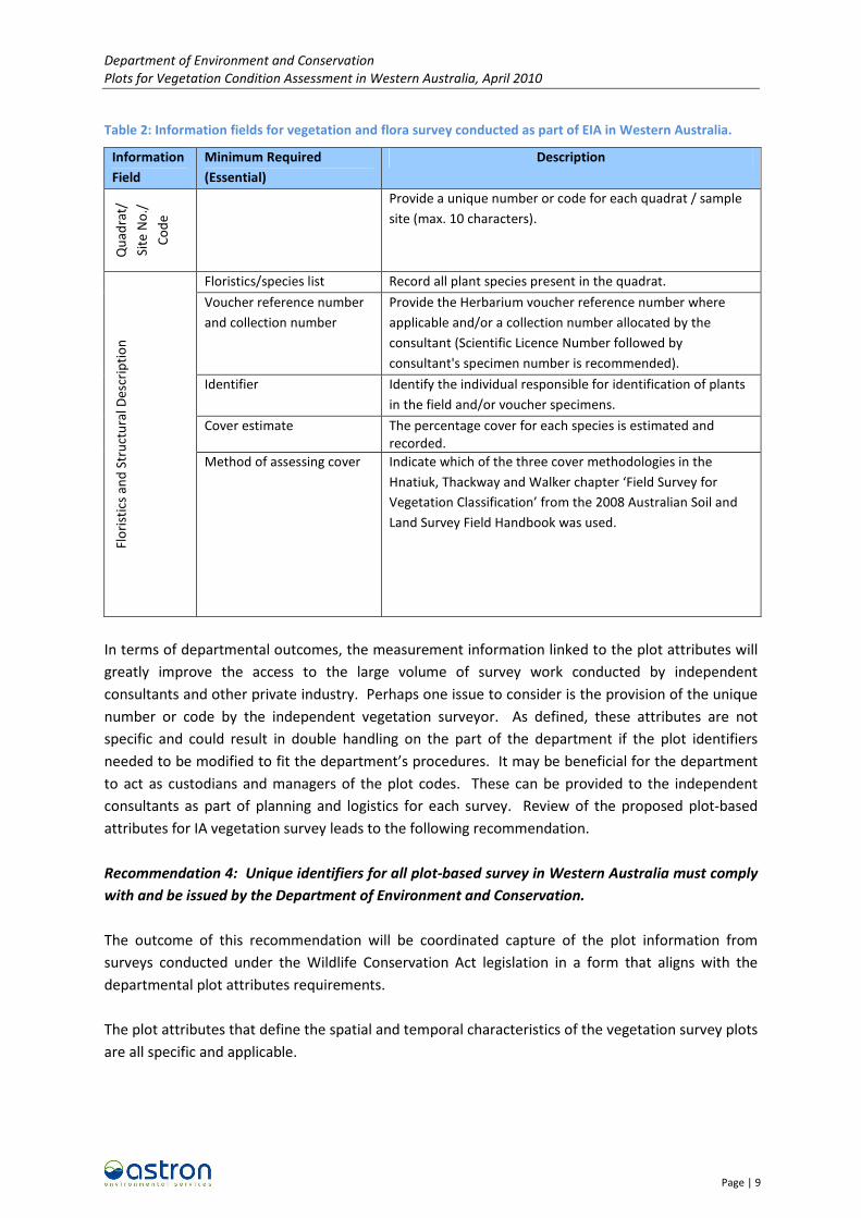
2.3 Environmental Management Branch (EMB)
As part of the state-wide Environmental Impact Assessment (EIA) process, the EMB are developing
guidelines for Terrestrial Vascular Flora and Vegetation survey. As part of this process, a minimum
standard of information is required. This is summarised in Table 2.
Department of Environment and Conservation
Plots for Vegetation Condition Assessment in Western Australia, April 2010
Page | 9
Table 2: Information fields for vegetation and flora survey conducted as part of EIA in Western Australia.
Information
Field
Minimum Required
(Essential)
Description
Qu
ad
rat/
Sit
e N
o./
Co
de
Provide a unique number or code for each quadrat / sample
site (max. 10 characters).
Floristics/species list Record all plant species present in the quadrat.
Voucher reference number
and collection number
Provide the Herbarium voucher reference number where
applicable and/or a collection number allocated by the
consultant (Scientific Licence Number followed by
consultant's specimen number is recommended).
Identifier Identify the individual responsible for identification of plants
in the field and/or voucher specimens.
Cover estimate The percentage cover for each species is estimated and
recorded.
Flo
rist
ics
an
d S
tru
ctu
ral
De
scri
pti
on
Method of assessing cover Indicate which of the three cover methodologies in the
Hnatiuk, Thackway and Walker chapter ‘Field Survey for
Vegetation Classification’ from the 2008 Australian Soil and
Land Survey Field Handbook was used.
In terms of departmental outcomes, the measurement information linked to the plot attributes will
greatly improve the access to the large volume of survey work conducted by independent
consultants and other private industry. Perhaps one issue to consider is the provision of the unique
number or code by the independent vegetation surveyor. As defined, these attributes are not
specific and could result in double handling on the part of the department if the plot identifiers
needed to be modified to fit the department’s procedures. It may be beneficial for the department
to act as custodians and managers of the plot codes. These can be provided to the independent
consultants as part of planning and logistics for each survey. Review of the proposed plot-based
attributes for IA vegetation survey leads to the following recommendation.
Recommendation 4: Unique identifiers for all plot-based survey in Western Australia must comply
with and be issued by the Department of Environment and Conservation.
The outcome of this recommendation will be coordinated capture of the plot information from
surveys conducted under the Wildlife Conservation Act legislation in a form that aligns with the
departmental plot attributes requirements.
The plot attributes that define the spatial and temporal characteristics of the vegetation survey plots
are all specific and applicable.

Department of Environment and Conservation
Plots for Vegetation Condition Assessment in Western Australia, April 2010
Page | 10
2.4 The Gnangara Sustainability Strategy
The Gnangara Sustainability Strategy (GSS) was a multi-agency project aimed to address issues of
water abstraction on the Gnangara Mound Aquifer. The project considered issues of environmental,
economic and social tradeoffs for various water abstraction scenarios.
As part of project planning, a Survey Methods Discussion Paper was written. This included reference
to data protocols and information management. The outcome of this process was to enable capture
of information by departmental officers, as well as consultants and other sources if applicable.
Therefore, the nature of the plot attribute criteria is somewhat broad.
With regard to vegetation survey, the following census form and location form criteria were
adopted.
• Census Form ID or Location Form ID;
• Report/survey name;
• Author/Organisation;
• Year;
• Observer;
• Polygon ID;
• Photo ID;
• Location ID;
• Date;
• Time;
• Easting (MGA 50 Datum – GSA 94);
• Northing (MGA 50 Datum – GSA 94);
• Slope (degrees);
• Aspect (degrees); and
• Altitude (metres).
Missing from the guidelines was direction for storage of information within the department, or
directions with regard to aligning plot unique identifiers with departmental requirements.

Department of Environment and Conservation
Plots for Vegetation Condition Assessment in Western Australia, April 2010
Page | 11
3 Conclusions
All programs that require the definition of plot attributes reviewed in the current review have
attributes in common. The outcomes suggest that a process is needed to unify this information
under a centralised storage mechanism. It is the recommendation of this review that a system of
DEC issued plot unique identifiers (plot numbers) be developed and tested. These DCEC issued plot
numbers should be for survey information captured within the department and also from external
sources that are given licence under the Wildlife Conservation Act.
4 Draft Plot Attribute Dictionary
The following list of terms that define the attributes of a plot are drawn from the FMB procedures.
They are provided to initiate discussion and allow modification to suit a wider departmental
application.
Plot Type Plot identifier that describes the type of
plot relevant to the field data collection
program.
Plot Number A unique number for each plot within the
plot type.
Location Geographic location of the centre or
designated and recorded corner of the plot
defined by coordinates, either northings
and eastings or latitude and longitude.
Datum used to record coordinates must be
reported.
Plot Size Plot dimensions (in metres).
Sub-plot number Sub-plot number nested within plot unique
identifier
Subplot Sizes Subplot size (if subplots are measured).
Assessor Person conducting plot measurements and
responsible for quality control of data.
Measurement Date Date of plot measurement.

Department of Environment and Conservation
Plots for Vegetation Condition Assessment in Western Australia, April 2010
Page | 12
5 References
Department of Environment and Conservation (2010). Resource Condition Monitoring Project.
Threatened and Priority Flora Report Form – Filed Manual. Prepared for the Significant
Species and Communities RCM Project, DEC. Kensington. WA.
Department of Environment and Conservation (2006). Forest Check Operating Plan. Prepared by
Science Division for the DEC. Manjimup, WA.