the ancient town at isar-marvinci, valandovo ancient town...viktorija sokolovska 5 the ancient town...
TRANSCRIPT

Viktorija Sokolovska
The ancient town at Isar-Marvinci, Valandovo
Cultural-historic survey

Viktorija Sokolovska 2 The ancient town at Isar-Marvinci, Valandovo
CONTENT
INTRODUCTORY NOTES 4
GEOGRAPHICAL IMAGE OF LOWER VARDAR VALLEY 7
ISAR – MARVINCI IN VALANDOVO VALLEY 9
THE HISTORY OF THE DISCOVERY OF ISAR - MARVINCI 11 EMPHASIS ON ANCIENT SETTLEMENTS IN THE REGION OF VALANDOVO - GEVGELIJA 13
REVIEW ON THE HISTORY OF THE LOWER VARDAR VALLEY 19 ETNICITY OF THE POPULATION IN THE LOWER VARDAR VALLEY 21
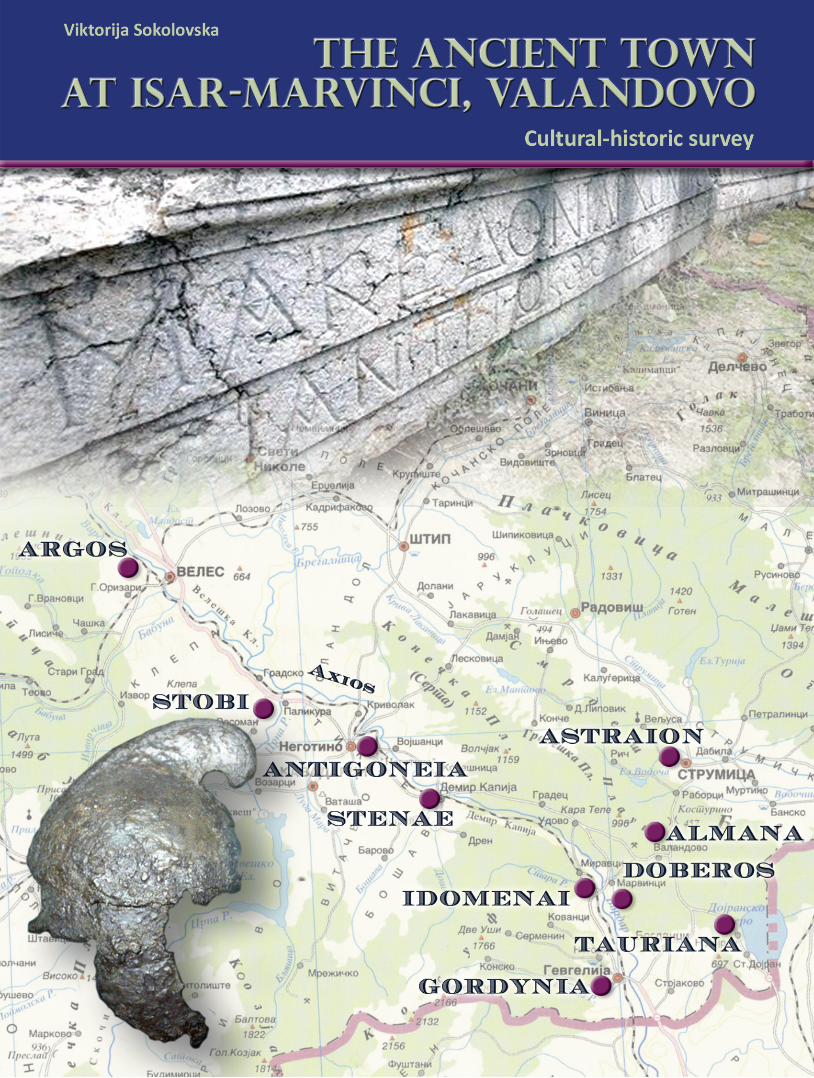
THE LOCATION OF THE CITIES IN VALANDOVO - GEVGELIJA REGION 23 ISAR - MARVINCI DOBEROS OR IDOMENE? 29
DOBEROS, IDIOMENE AND GORTINIA IN THE ANCIENT SOURCES 33
DOBEROS IN LIGHT OF THE ARCHAEOLOGICAL RESEARCHES 35
APPENDIX 57
BIBLIOGRAPHY FOR THE LOWER VARDAR VALLEY 58
PLANS 65

Viktorija Sokolovska 3 The ancient town at Isar-Marvinci, Valandovo
Publisher PORTA ARCHAEOLOGICA http://porta-archaeologica.com Editor in chief Горан Санев Author PhD. Viktorija Sokolovska Translation Lenche Sokolovska Design and Layout Gordana Georgievska Skopje, 2012
CIP - Каталогизација во публикација Национална и универзитетска библиотека "Св. Климент Охридски", Скопје 904:711.424(381)"652" СОКОЛОВСКА, Викторија Античкиот град на Исар-Марвинци, Валандово [Електронски извор] : културно-историски осврт / Викторија Соколовска. - Текст, слики, географ. карти. - Скопје : Култура ест, 2011 Начин на пристап (URL): http://porta-archaelogica.com. - Наслов преземен од екранот. - Опис на изворот на ден 6.06.2011 ISBN 978-608-65300-0-6 а) Исар-Марвинци (археолошки локалитет) COBISS.MK-ID 88626186

Viktorija Sokolovska 4 The ancient town at Isar-Marvinci, Valandovo
INTRODUCTORY NOTES
The year 1976 was a crucial year for the archaeological researches along the valley of the river Vardar. Until then, along this biggest Macedonian river there were known several sites, but Stobi was the most significant one and, at the same time, the most prominent in the field of science. It was discovered between the two World Wars, and got famous especially through Yugoslav-American researches in the 70s of the last century1. A cemetery, well known in the archaeological circles,was incidentally discovered in Demir Kapia in 1948, during the construction of lime-kiln, when the Greek vases came to light, unknown up to that day on the territory of the Republic of Macedonia, and became a very important collection in the archaeological department of the Museum of Macedonia in Skopje2. After the Second World War, a significant number of excavations were carried out on these two sites, investigating some sectors and details whose results were published in the country and abroad3. The other parts of the Vardar valley with traces from the past, were hardly known in the archaeological circles. These very circumstances attracted attention of the investigators and challenged them to get more information about what happened in this areas in the past, to find out when the life began in these settlements, how they looked like, the range of their development in some periods of time, the material and spiritual culture, to which ethnic group did the population belong to, in others words, to discover and investigate prehistoric period in Macedonia and the transition of Macedonia to the historic period with all phases of its political and cultural history. Because of the interest of individuals, followed by the enthusiasm and personal intuition, an advocacy project was prepared by experts - archaeologists in the Archaeological Museum of Macedonia, as a program activity for the following period.
1 For the bibliography of Stobi I refer to: И. Микулчиќ, СТОБИ, МАГОР, Скопје,2003,203 и н., V.Sokolovska, Investigations in the house of Peristerias, Studies II, Beograd 1975, 123-141; same, Stobi in the light of ancient sculpture, Studies III, Beograd 1981, 95-106; for the entire sculpture of Stobi, see: the same, Античка скулптура во СР Македонија, Скопје 1987; Исар - Марвинци и Повардарјето во античко време, Скопје 1986, 43-45 2 Ј. Корошец, Заштитно ископавање у Демир Капији 1948 г., Зборник на Археолошки музеј, Скопје 1956, 90-107; Д.В. Тодоровић, Грчки гроб из Демир Капије, Старинар IX-X, Београд 1959, 281-296; same, Античка Демир Капија, Старинар XII, Београд 1961, 229-254; Н. Петровић, Демир Капија, Архитектонски налази на сектору Манастир, Старинар н. с. 12, Београд 1961, 217-227; И. Микулчиќ, Накит класичног доба из Демир Капије, Старинар н.с. Београд 1970, 135-138; В. Соколовска, Светилиште на Диоскурите кај Демир Капија, Жива Антика XXIV/1-2, Скопје 1974, 267-279; same, Новија археолошка ископавања у Демир Капији, Старинар н.с. XXIV-XXV, Београд 1975, 182-192; same, Археолошки истражувања во Демир Капија, М aced.acta Archaeol. 4, Прилеп 1978, 93-112; the same, Исар - Марвинци 47-51; И. Микулчиќ, Хеленистички тврдини во Демир Капија и Бабуна, ГЗФФ 34, Скопје 1982, 127-143; the same, Топографија на Стенае - Просек - Демир Капија, ГЗФФ 41-42, Скопје 1988-1989, 65-88; same, Антички градови во Македонија, Скопје 1999, 176-182. 3 See ref. 1 and 2

Viktorija Sokolovska 5 The ancient town at Isar-Marvinci, Valandovo
In 1976, the Department of Science approved the project “The Vardar Valley in the 1st millennium BC”, prepared and realized by Dr Viktorija Sokolovska and Mr Radmila Pasic Vincic, both archaeologists and workers in the Archaeological Museum, later a part of the Museum of Macedonia. In that time, the interest was directed towards the lower Vardar Valley, particularly because of the indications received during the surface investigation on the ground in that part of Macedonia, systematically performed by the Archaeological Museum of Macedonia4. The choice fell on these sites: - Vardarski Rid near Gevgelija, known in the archaeological science, as a site where Macedonian bronzes were found in the cyst-type graves and items from the classical period. Those elements were enough to lead to the conclusion that there was a settlement from the period of the Iron Age and early antiquity interesting to explore5. - Meleznik-Dedeli, the site situated between Valandovo and Dojran, where were found cyst-type graves and pythos-graves, elements that unambiguously indicated it was a settlement of the early Iron Age6. - Isar-Marvinci, the site well known from the first excavations performed in 1961 on the place called “Porta”, where later there was discovered a temple with an inscription which mentions the local Makedoniarh7. Field researches and excavations that followed in the coming years justified our interest. The results were fascinating. A picture of the life along the Vardar Valley emerged with great power in front of us and a world we could only dream of was revealed. Our horizons expanded to an unprecedented scale. Results which surfaced greatly changed our previous perceptions, knowledge and findings that ruled previously in the archaeological science. The newly created conditions enabled us to investigate the cultural development of Vardar Valley in the 1st millennium BC, leading to a condition to clearly connect and explain, then insufficiently clear occurrences of the older Iron Age and early antiquity of our country.
4 A team of the Museum, composed of R. Pasic Vincik, S. Sarzoski and V. Sokolovska, conducted recognition on the territory of Municipality Gevgelija with Valandovo as an integral part, during the previous period. On that occasion were discovered the micro-locations of Dedeli, Valandovo, Suva Reka, Paragon, Vardarski Rid in Gevgelija, a settlement from the Hellenistic time with a shrine or a mausoleum at Pirava, a cemetery from the Iron Age at Sobri and others. See: Археолошка карта на Р. Македонија, Том II, Скопје 1966. 5 In the Museum of Gevgelija, there were several items from pre-Roman period discovered accidentally in the field of Vardarski Rid. 6 With the aforementioned recognition, in the village Dedeli itself, we ran into tombs. On the village playground was still standing phitos visible on the surface, for which was established to belong to a tomb. In the outskirts of the village there was a visible cyst tomb, which on this occasion was excavated. There were found some bronze items, including one spectacle fibula. 7 In 1961 were obtained some funds for digging at Isar - Marvinci. The importance of the site was confirmed by previous exploration of the surrounding, and collecting findings discovered by the village population. In his archaeological collection at the NU of Gevgelija, there was the terracotta of Cybele with the lions, the statuette of Aphrodite, the statue of Artemis and other items collected by the director Spaso Gjorov. The first excavations established the idea of the significance of the site.

Viktorija Sokolovska 6 The ancient town at Isar-Marvinci, Valandovo
However, funds for each research campaign were too modest so that it was almost impossible for a shorter period of time to reach a greater knowledge, get answers to questions and form a desired image of life settlements. The further course of the field research was conducted slowly, with small funds, great cuts and great personal sacrifice. But despite all the difficulties, the persistence of the researchers was crowned with results, so that it can be said that the goal was achieved: a picture of the sites to which interest was directed was formed, and the results which came filled a void of prehistoric and ancient history of Macedonia, occupying such a place in archaeological science that met the invested energy and efforts of the researchers. Excavations that are now taking place complement the existing picture, enriching performance on the content of life and illuminating some moments that are related to the development of the settlement from its inception and emergence as civilized agglomeration, its further development, as well as events that occurred in cities in Vardar Valley in the I millennium BC, which left visible traces of their existence.

Viktorija Sokolovska 7 The ancient town at Isar-Marvinci, Valandovo
GEOGRAPHICAL IMAGE OF LOWER VARDAR VALLEY
Demir Kapija Gorge, the majestic barrier formed by the last slopes of Kozuf and Graeshka Mountain, divides the flow of Vardar into Intermediate and Lower Vardar Valley. Among these powerful rocks, Vardar victoriously continues south to pour its waters into the Aegean Sea. This extraordinary sight with magical powers attracted the attention of archaeologists of my generation, with a hidden desire to penetrate inside and see what is hidden in her bosom. Along this wonderful Macedonian river, like a pillar around which was formed the core of the people that inhabited it, in the past took place life filled with turbulent historical and cultural events. Since ancient times this river was collecting people. giving refuge to passers by, creating a culture while receiving foreign influences and, therefore, lived a dynamic life that preserved visible traces, and at the same time kept, cherished and passed cultural traditions, maintained continuity in the cultural development of populations that inhabited its shores. Today, when along the modern highway a traveler comes from the north, he will pass amidst mighty rocks to the south and will find himself in a different environment and under different sky. If at the beginning of the journey the weather was rainy, in the south of the canyon the sky would open and show different horizons. It means that you are in a new environment where some other plants grow, where you breathe some other air. But it won’t be felt at once. You have to stay a moment longer to perceive that you are in new climate conditions, where oleanders and pomegranates grow, where the lime trees emit a heady fragrance, where silk beetles were cultivated and did silk, where large vine plantations born beautiful grapes. It is the Valandovo - Gevgelija’s field, a field separated by the river Vardar. But unlike Gevgelija’s field, Valandovo’s field is an earthquake prone area, because of its placement in the opposite direction of the river Vardar. It is a consequence of lowering of Belasica opposed to Valandovo depression, whereby in a large time span comes to earthquakes with devastating force. In 1931, a strong earthquake with a magnitude of 10 degrees in a great extent destroyed the city. The inscription on the monument placed in the center of the city is a reminiscent of the trauma. Such strong earthquakes, seismologists say, happen once in 1000 years. At one point of time, in the same way was destroyed the ancient town Isar, at the village Marvinci. Otherwise, earthquakes with lower intensity here occur every 10-15 years. On May 24, 2009, at about 6.20 pm, an earthquake with force of 6 degrees on the European macro seismic scale again shook Valandovo. There were no victims. Valandovo basin covers 331 square kilometers. In the North it is closed by the mountain ranges of Kozuf and Graeshka Mountain, whose ending slopes form the Demir Kapija gorge. In the East it is framed by the last slopes of Belasica and Plavush by whose passable grasslands it is associated with

Viktorija Sokolovska 8 The ancient town at Isar-Marvinci, Valandovo
Strumica Field. From the Dojran area to the South-East, it is separated by mild hills where Kazandol and Furka are situated. The Vardar River forms the Western geographical boundary of the valley, behind which rises the wavy range of the picturesque Kozuf. From east to west, crosses the river Bojmica (Anska River) cutting the plain. Its springs are in the western mountain slopes of Belasica and it flows into the Vardar River in the northwest of the most distant southern slopes of Pogana- Isar hill. As a result of the openness to the south, the climate in the region is changed to Mediterranean. In fact, Belasica occurs as a climatic boundary between the southern Mediterranean and moderate continental climate of the north. At the same time, Belasica occurs as the boundary between the northern regions where deciduous forests grow and southern regions, where the evergreen shrubs known as prnari, appear. This is the place where people cultivated tobacco, cotton and, in the past- silk beetles. Gardening cultures are of good quality and large plantation vineyards provide high quality grapes. In the recent past poppy was largely cultivated here, as well as its byproducts. Undoubtedly, this plant was cultivated and widely used in the antiquity as well, which was confirmed by the archaeological excavations8. Valandovo basin is horrendously rich with ore pools. In the ancient times copper was exploited in Kazandol. Mines of copper in Dedeli were exploited since early antiquity. In Kosturino lie deposits of iron ore. Mines in Rabrovo are rich in copper and chromium ore. The rinsing of gold, in this region rich in gold-bearing rivers, was common even in the antiquity. But the range of the mountain Kozuf was probably the leader because there are the richest ore deposits exploited in antiquity. The interest for these pools lasts until today. There lie layers of copper and lead - silver ore bearing gold, arsenic, antimony and thallium, and iron - nickel ore. Confirmation of the use of these ores in antiquity is preserved in tangible evidences. Exceptionally large number of items of the so called 'Macedonian bronzes' are discovered and more are to be discovered in the cemeteries of the older Iron Age in the lower Vardar Valley, as well as in the Paionian northern regions, which, in turn, are typically ethnic-cultural features of these areas. A testimony, for processing of ore at the very settlements, is the numerous ore mills discovered at the sites in the Vardar Valley and in Eastern Macedonia. Who knows how many times the information preserved at Strabon was confirmed, that Paeonia was rich in gold. Situated in the lower Vardar Valley, the Valandovo basin had a significant traffic role in the Balkans. Besides the Vardar road (Via Axia), which is the current highway, there was also a road which via Dojran made the connection with the Aegean coast and via the Strumica field led to the middle flow of Struma and Serdika. 8 The used data are according to: В. Картов, Валандово и Валандовско низ историјата, Скопје 1972.

Viktorija Sokolovska 9 The ancient town at Isar-Marvinci, Valandovo
ISAR – MARVINCI IN VALANDOVO VALLEY
The archaeological site Isar is located above the village Marvinci, on its southwestern side. The hill is accessible from south through a broad saddle. Ever since early antiquity, thereby was passing a road which was lowering from the acropolis to the level of the riverbed of Vardar, continuing to Grchishte or Gloska Chuka. Here, at the place known as 'Separation', the Vardar River has a firm rocky bottom, which made crossing on the other side of the river easier. The other sides of the Isar are steep; a circumstance which provided safety and protection of the settlement that occurred here and held more than 1500 years. Isar is a protruding point in the midst of the basin, a place where severe winds blow. The acropolis is located on the highest quota of 131 m above sea level and had to be well protected from atmospheric conditions. The oldest traces of settlements’ layers are extremely impressive. Residential houses are located in positions supported by rocks, where, at certain places rocks slit to a certain depth in order to achieve stability and protection of residential and economic buildings. This is the picture we get from the remains of the oldest settlement, which stretches below the acropolis, and mostly on the ridge that extends southeast from the later Roman castrum (Fig. 1, Fig. 2).
Fig. 1. A view at Isar-Marvinci The form and type of the settlement situated on Isar was stipulated by the terrain configuration. It is a settlement of the so called slightly broken type, with objects located in places suitable for existence. The most compact appears to have been the acropolis, which dated from the early antiquity, with objects that belonged to residential buildings. The future extensive excavations will

Viktorija Sokolovska 10 The ancient town at Isar-Marvinci, Valandovo
certainly make it possible to perceive the whole picture of urban planning settlement. The cemeteries of any temporal epoch were laid all around town on a huge space, adjacent to the residential quarters of the living space. From the acropolis, the road lowered downwards through the southern cemetery and led to the foothills of Isar, which was common in antiquity. The fertile environment certainly had a favorable influence upon the development of the settlement and the supply of the population with living products, especially grain products. The importance of this food product for the inhabitants is conformed by the presence of a distinctive number of phitos as storages for grain, found everywhere in the settlement, in long periods of living, starting form the early Iron Age, through early Antiquity, to the time of the Hellenistic-Macedonian period and, especially in late antiquity, when this phenomenon is most striking. The settlement of Isar had no shortage of water. The immediate vicinity of the river Vardar certainly was of primary importance. The springs at Janova Cesma were used for drinking water from the earliest times. A complete system of waterworks was constructed in the early Roman period. The water was brought from Vrezi Dol i.e. from the location of Pogana, a place from were the system of waterworks occasionally coincides with the contemporary paths of the site. In any case, on the highest terraces of Isar, directly under the acropolis, were discovered water systems that demonstrate the presence of large quantities of water, such as channels for water, town baths with a complete system for providing water for the buildings of this kind. For this important moment of the existence of the town, we will discuss in the further exposition.
Fig. 2. Some of the discovered objects at Isar - Marvinci

Viktorija Sokolovska 11 The ancient town at Isar-Marvinci, Valandovo
THE HISTORY OF THE DISCOVERY OF ISAR - MARVINCI The oldest information concerning Isar - Marvinci and its environment comes from the time of the First World War, when at the site was discovered and in the meantime, were published several items from sites in Dedeli and Marvinci by V. Pingel and Dragendorf. Isar, near the village Marvinci, was for the first time registered in our literature as an archaeological site by M. Grbic. Later, M. Kornjakov published the marble architrave joist with a Greek inscription on it, which is still on the place where it used to be in the past-at Isar, Marvinci9. The site was used as mine from where inhabitants of the village took stone for their houses. Thanks to its bid dimensions, the architrave was saved. Since the ancient times, this site served as a mine from where the local population was supplied with stone, during which many convenient blocks were built in the rural houses. Due to its large size, the architrave was saved from destruction. Borka Josifovska paid a special attention to this site and over a long period of time she was studying it and, later on, published the previously discovered findings. In 1961 Josifovska, in cooperation with the author of this work, performed the first excavation of the Isar. The interest was turned towards the discovery of the temple, so in that campaign was discovered the first step of the temple and a part of the rampart near the gate. On this occasion, a burial monument of Zoilos was discovered, with a soldier with Macedonian shield depicted on it. (Fig. 15) At the same time, there was discovered a canal for carrying water to the neighboring terrace, later labeled as Sector VI. As mentioned in the introduction, in 1976 started the implementation of the project 'The valley of Vardar in the 1st millennium BC. According to the program based on the actual situation, the first excavations began in the bed of the river Suva Reka in Gevgelija and the area named Paragon, spanning besides the riverbed, where were located cemetery with cysts type tombs which belonged to the older Iron Age. The sandy terrain allowed excavation to take place without any major difficulties and without delay. The results were more than satisfactory10. At the same time, there were set some test probes on the Vardarski Rid, and discovered cultural layers of settlements. Thus, the systematic excavations of the site which were yet to come next year got their justified confirmation. During this exploratory campaign, in the archaeological literature was set up the term "Vardarski Rid" as a toponym for this site versus 'Gevgeliski Rid', which was also in use. 9 V. Pingel, Eisenzentliche Graber von Dedeli und Mravinca in Jugoslawisch – Makedonien, according to Р. Васић, Нови елементи за проучавање гвозденог доба Вардарске долине, Старинар XXVI 1977, 1 and on.; М. Грбиќ, Археолошки наоѓалишта во Македонија, ГМКД на НР Македонија, Скопје 1954, 115; К. Томовски, М. Ќорнаков, За некои споменици од југоисточна Македонија, 29 and on. 10 Р. Пашиќ, Археолошки истражувања на локалитетот Сува Река во Гевгелија, Мaced. acta Archaeol. 3, 1977; Археолошки испитувања на локалитетот Сува Река во Гевгелија 1978; Повардарје у старијем гвозденом добу,

Viktorija Sokolovska 12 The ancient town at Isar-Marvinci, Valandovo
The following 1977 started the excavations at Isar - Marvinci. A site of such dimension was a challenge and a dilemma at the same time, of where to direct the excavations to. Nevertheless, the choice fell on the acropolis, so after several trial probes square-nets were placed that were systematically researched from 1977 to 1980. This was the first excavation of a settlement from the pre-Roman period in Macedonia, performed with great uncertainty and fear for all that could still happen. In the meantime, in 1978, began the excavation of the Sector I, which means an area where the Roman temple and ramparts of the gate were located and the place where excavations were carried on by Borka Josifovska and the undersigned, in 1961.The excavations in this sector lasted for several years with significant disruptions, until 2008. In 1982 the excavations began in the southern cemetery, and continued for years to come, but also performed intermittently. As was established later, in this area were performed burials in the pre-Roman and Roman period, i.e. from the end of the fifth century BC, until the fourth century AD11. The excavations in Lisicin Dol started in1977 when the existence of a cemetery of the late Iron Age was confirmed and some interesting incidental findings of the so called 'Macedonian bronzes’ came to light, obtained from the object finders in 1961. The same research campaign also resulted in finding cemeteries of the same period on several points in the area of the Isar. The Lisicin Dol excavations continued in 1997 and in turns, with some interruptions, last even today. Southeast from the military castrum, on one rocky ridge where illegal diggers have discovered and robbed many tombs, in 2009 was conducted a systematic excavation. There were revealed many tombs, densely embedded in the rock, almost without exception since Roman times. Diversity of tomb architecture and burial ritual discovered on this occasion provided an opportunity to study the mode burials in Roman times in this region and consideration of various forms and types of the tomb architecture practiced in antiquity.
11 The results of the excavations for the period 1983/84 were published in: В. Соколовска, Исар - Марвинци и Повар-дарјето во античко време. See ref.1.

Viktorija Sokolovska 13 The ancient town at Isar-Marvinci, Valandovo
EMPHASIS ON ANCIENT SETTLEMENTS IN THE REGION OF VALANDOVO - GEVGELIJA
The field research in Valandovo - Gevgelija region, performed by the periodical excavations, allowed us to establish the locations of the settlements, their approximate size, time of their occurrence and disappearance. These are the results obtained gradually over the last three decades, launched with the project 'Valley of Vardar in the 1st millennium BC. Those of greater significance will be mentioned here. Demir Kapia – Stenae The role of this settlement as a strategic site has been highlighted many times in science, so our focus on the settlements in the region will begin with the review of Demir Kapia, although it is not an integral part of Valandovo Valley. Striking traces of fortresses are preserved on the peaks of the two stone ridges that form the gorge of Demir Kapija, which are completely destroyed. Somewhere there are preserved parts of the ramparts built in drywall technique and formed by large square blocks. The fortress extended from the top of the gorge to the east, in length of 900 meters, where she ended with the massive rectangular tower. It is already noted in the science that remains of important stronghold are in question. Stated assumptions about the nature of this fortress as Paionian, its characteristics and technique of construction, indicate the archaic period as a time when it was raised. In recent times this has been confirmed by the research of I. Mikulcic who thought that here was located the residence of the Paionian rulers. And on the opposite, western side of the gorge, on the plateau Ramniste, there are the remains of ruined ramparts, ranging over the crest in length of 120 m. On the northern slope known as the Manastir, there are preserved traces of a path in length 20 of meters, used in antiquity. The cut in traces of wheels in a distance of 1.25m, testify for the long use of the road. In the newest developments, Mikulcic gives a complete picture supported by personal field observations, the complex of settlements within the region, their location and micro locations. The occasional discoveries of site during the expansion of the road, as well as with the archaeological excavations in Manastir and the ground around the modern hospital near the mouth of the river Sosnica, caused the discovery of a cemetery, on the basis of what the knowledge about this important site was gained. Generally speaking, it may be said that the settlement originates from late Bronze Age. Its development is mostly achieved during the early antiquity, in the 5th century BC, as a result of the presence of the settlers of Attica who formed their own colony at this location. Pottery- style red figures discovered in the cemetery, among which white lekythoi typical for the burial ritual of the Athenians, undoubtedly confirms the presence of settlers from Attica. Another testimony of the prosperity of the settlement at that time are the findings of other samples

Viktorija Sokolovska 14 The ancient town at Isar-Marvinci, Valandovo
of refined gold and silver jewelry made in Chalcidice thoreutic centers. The presence of these settlers from the south is due to their interest and search for deposits of precious metals, which this region of Demir Kapia was rich with. The settlement at Demir Kapia experienced a new wave of immigrants after the obvious stagnation and impoverishment which occurred as a consequence of the events, such as the invasion of the Celts of Delphi in 280/279 year, a situation common for all settlements in the Vardar region. It happened during the reign of Philip V, who settled and rebuilt the settlements ruined by Celts, with colonists who brought a new momentum in the settlements of Vardar region. That is the time of origin of the sanctuary dedicated to Dioskures, and the place where the small statues and reliefs in round plastics with a display of the Triada were found. During the Roman period the settlement did not experience a particular growth and progress, but still participated in the contemporary events in Macedonia. In the early period of the empire a number of public facilities were build, such as the temple built in Ion style, parts of which are occasionally discovered on the site. The coins findings, especially jewelry show the rise of individuals. It is interesting to emphasize that, at this very site in Demir Kapia, was discovered a portrait of a man who bears features typical for portraits of Galien, as a representative of late Roman portrait art in Macedonia12. Isar - Tower, Valandovo Traces of settlement are discovered at the mountain ridge north of Valandovo. Excavations were not carried out, but the occasional findings give us opportunity to form a picture of the beginnings of this settlement in the area known as Bojmija or Boimia. The settlement was spread on much bigger space than what we can imagine today. In this case, it is also a settlement of scattered type. Traces of the late Bronze Age i.e. the transitional period, are preserved in the pottery which is occasionally encountered. The cemetery of Zeleniste located at the foot of Isar, which today is in the circle of a modern hospital, confirms that people were living there in the 7th- 5th century BC. Traces of early antique buildings with walls without mortar are ascertained on the terraces of Isar, which helped us to determine the size of the settlement at that time to be of 5-6 hectares. In the early Roman time this town fell into crisis, but again, in late antiquity it was experiencing prosperity which is shown with the appearance of an ecclesiastical complex flourishing during the 4th and 5th century13. Meleznik – Dedeli The settlement lies next to the village Dedeli, spread on the ending slopes of Belasica. Excavations that followed the discovery of the site were aimed at researching the cemetery. It didn’t last long.
12 See ref. 2 13 The most complete data for this site at: И. Микулчиќ, Антички градови во Македонија, 20 and on.

Viktorija Sokolovska 15 The ancient town at Isar-Marvinci, Valandovo
The settlement existed in the Iron Age, with probably the older tracks. It is a classic example of the culture of late Iron Age in the Vardar region with sepulchral items typical for the areal inhabited by Paionian population14. Vardarski Rid (Gortinia), Gevgelija At the eastern edge of the vast Gevgelija Field, just above the river Vardar, raises Vardarski Rid. These are actually two hills separated by a slight saddle. Extensive excavations were conducted at the eastern hill, at the highest section of the foot. Excavations have shown a clear stratigraphy in the development of the settlement. The oldest horizon is bound to the late Iron Age, the 7th-6th century BC. The remarkable presence of metal items in cemetery from this time, imposes the conclusion that in the settlement metallurgy and local production of metal burial enclosures was largely developed. To the pottery, which occurs at that time, is attributed local origin. For the classical period, the appearance of an object constructed by rectangular carved stones described as stoa, is really striking. It was a building, where in the semi-open space were gathering citizens, merchants and artisans, i.e. business people. This technique, even in more perfect form, was applied to objects found far north, in Brazda near Skopje, Krsevichko Kale near Vranje, on the hill Krakra in Pernik. In the professional literature, the origin of this construction system and the role of the facilities have already been pointed out. In the Hellenistic period, the settlement developed its own production of pottery, ceroplastics and other handicraft products. Generally, it can be concluded that we deal with a rich settlement that owes its prosperity to its position in the Vardar Valley, on the main highway that connected the Aegean Sea with the provinces of the Balkans, through permanent links with the South and embracing the benefits of civilization pilled in the cultural development of Macedonia. The life of Vardarski Rid was fading out with the end of 1st century BC, to leave tangible traces of its last days in the 1st century AD15. Gradisor-Mramor, (Idomene?) Miletkovo Around the village Miletkovo, a significant concentration of sites appeared, scattered across a wider area whose research would light up several problems from this important site for which we know very little. Individual data emerge on the surface due to surface observations or occasional
14 Д. Митревски, Дедели, Скопје 1991; See, Археолошка карта на Р. Макeдонија, Том II, Скопје 1996, 54-55. 15 В. Соколовска, Исар - Марвинци, 51-54; W. Neidingen – E. Matthews, Excavations at Gevgelija Stratigraphic,Architectural and Historical Report, TFAHR, Houston/Texas, 1995 and 1996, 1-31; Б. Хусеновски - Г. Спасовска Димитриеска, Вардарски Рид – Гевгелија, Истражувања во 1994 год. МАА 15, 1996-1997, Скопје 1997; Б. Хусеновски, Античките монети на Вардарски Рид, Гевгелија 2004; Е. Сламков, Уметноста на Вардарски Рид, Гевгелија 2004; Б. Хусеновски, Депо на сребрени тетрадрахми од III век пр. н. е., Вардарски Рид, Том I, 323-345; Б. Хусеновски - Е. Сламков, Водич низ постојаната археолошка поставка, Гевгелија 2005, Д. Митревски, Старомакедонски град на Вардарски Рид, Скопје ; Група автори, Вардарски Рид, Том I, Скопје 2005.

Viktorija Sokolovska 16 The ancient town at Isar-Marvinci, Valandovo
incidental findings. There have been ascertained burials from Roman times, and as most interesting information, there is the revealed a part of a road. Researches, which took place lately, inspire the hope that in the future a greater attention will be paid to this site. Excavations conducted by the museum in Gevgelija on the site of Gradisor-Mramoe, discovered an object identified as a Roman house, dating from the 4th century, with coins and ceramic findings in it. These studies revealed layers of a settlement from the late Iron Age, which should be considered as a confirmation that the settlement was established at this time which, without doubt, should be expected. These initial field studies, which should in future be extended to a larger space, will allow getting a fuller picture of this settlement, which was located on the main highway that connected the Aegean coast to the interior of Balkans16.
* * * The knowledge that is already gained about the region of lower Vardar Valley, allows us to summarize it in a historically - cultural and chronologically completed whole, seen from a comprehensive perspective. As far as we know, modest but confident signs of life from the Neolithic period have been discovered on the territory of lower Vardar Valley by now. It is the Bronze Age when we come across tangible residues which testify that settlements on several places arose in the region at this time. At the site Bogorodicin Rid – Kofilak, near Gevgelija, located above the cemetery Milci, a settlement was discovered which, as it seems, had shorter life. In settlements Vardarski Rid, Isar in Valandovo, Isar at Marvinci, and probably in the vicinity of Miletkovo, the life began in the Bronze Age. At the moment, a precise date of their foundation can not be determined, given that the ceramic forms that follow last for a long time, but analogous to the settlements in Kastanas, Vardina and Vardarovca, it can be assumed that they were founded by Bronze Age invaders of the lower Vardar Valley. Judging according to names we know, the settlements on the west side of the Axios were founded by Cretan settlers who, after the destruction of Knossos around 1400 BC., and led by Botton, settled in the old Emathia, which by them would later be called Bottiaia. It is the time when the so called transitional period began (1300-800), which definitely coincides with the beginning of the life in our settlements. Until the late Iron Age we can not speak of settlements in the proper sense of the word. In this period came to a large influx of population, which, attracted by mining resources of the region, found its existence in this area. The settlements of Vardarski Rid, Meleznik at Dedeli, Isar in Valandovo and Isar in Marvinci, prevailed.
16 Е. Сламков, Градишор - Мрамор, село Милетково, Македонски Археолошки преглед, 1, Скопје 2008, 160-165.

Viktorija Sokolovska 17 The ancient town at Isar-Marvinci, Valandovo
The economic growth of these settlements, considering the time that proceeded, confuses with its content. And, while the picture of life in the settlements shows a modest living, cemeteries show considerable wealth. Grave artifacts made of metal, with the versatility and technique of production, show a high technology in the processing of ore, which reflects the high level of civilization to which the local population had raised. Their forms and purposes speak of the spiritual side of life of the population, a phenomenon not seen so strikingly expressed in other nations. Also, the ceramic products, no doubt locally made, stand on a remarkable level. The technology of preparation, the shapes and the decoration are, without doubt, a reflection of the Mediterranean influence, but here widely applied in new circumstances and new conditions. One striking phenomenon that can not be easily explained is the end of the life of the settlements in the region. The Kofilak life faded away with the onset of the late Iron Age (around the 8th century BC). The settlement Meleznik at Dedeli after a remarkable rise, did not experience the archaic period. But, a small settlement at Visov Javor shows elements, although in a modest scale, that stands in a close connection with Trebenista and Sindos, i.e. the culture of Trebenista17. The life on Vardarski Rid continues with the same intensity. The culture of the classical period in local conditions, reached an enviable degree. This particularly happens in the Hellenistic period, when it comes to populating the new wave of migrants from the south during the reign of Philip V. The remains of settlements, mostly the grave reports, show uniformity, and that means - the presence of a population originating from regions with similar habits and the same fashion novelties, with the same attitude towards secular and spiritual side of life. But after the fantastic growth, the life on Vardarski Rid faded away, together with the end of Hellenism. Whatever the reasons (probably the unfavorable living conditions), once a progressive city, with a status of the polis (Gortinija?) since the fifth BC, now has reached its end18. What happened to the population we do not know. We can only assume that they moved to the neighboring villages. The on-going researches on the opposite side of the Vardar, in the area of the village. Miletkovo, are still in their initial stage, so we can not speak to this more specifically. If we are right in locating Idomenai here, then we would certainly expect its existence to last to the end of antiquity. But, the town of Isar - Marvinci lived with the same intensity during the first millennium. After the extraordinary growth it experienced in the late Iron Age, which appeared to be adequate to that of Meleznik - Dedeli and Vardarski Rid with its cemeteries, with the beginning of the early Antique period it also experienced a significant development. At that time, a wave of settlement population from Hellenistic South, arrived with ceramics produced in the Attic workshops. Those were people who migrated in search of mineral raw materials - metallurgists, traders, craftsmen, who would
17 For the cemetery at Trebenista - Gorenci, I refer to: В. Соколовска, Етничките носители на Требенишката некропола, Скопје - Охрид 1997, with the entire literature connected with the problem of this cemetery. 18 See the aforementioned literature ref. 15; Е. Јованов, Крајот на животот на Вардарски Рид, Вардарски Рид, Том I, 315-322.

Viktorija Sokolovska 18 The ancient town at Isar-Marvinci, Valandovo
bring new impulses in the economy as well as in art and spiritual life of the natives. These developments were widely accepted by locals. They brought a new kind of burial. Despite the inhumation, the cremation got in practice greatly, too. The respect to the sun which dominated in the spiritual life of the local population was being replaced by the worship of Apollo, Dionysus, Kibela, Artemis and other Hellenic deities. In this period, Isar - Marvinci was the leading settlement in the region of Valandovo and Gevgelija. Despite the presence of import, mostly of Attic pottery, the local gray ceramics were still being produced, reflecting the conservative habits of the local population. But, it came to a striking novelty when starting to produce ceramics that mimicked the Hellenic forms, but produced in gray invoice, which, at least according to their function, replaced the expensive Attic vases. This particular mass production mostly occurred in the northern Paionian region: Knezje - Sveti Nikole (Bylazora), Gradiste-Brazda near Skopje, Krsevica near Vranje and in all settlements on paionian-agrianian territory19. In the following Roman period, Isar was again the most important settlement in the region. There were stationed the newly settled Romans who had their own convent. The building of a temple, shrines, town thermae, and of course, other public buildings of the town, marked the style of life which gained a higher civilized level of living, reflecting the demands of time and economic opportunities. In this period the town experienced a catastrophic destruction caused by an earthquake (?), and a devastation made by the Goths in 268 AD, which left visible traces. Meanwhile, as a consequence of the political events in the kingdom, there rises a military castrum, which was later on used for settlement and as the main hideout of civilians. But in the late Antique and Early Byzantine period the life here began to stagnate, and the settlement of Valandovo took over the primacy. Whether due to the inappropriate field conditions or other, to us unknown reasons, the town of Isar was gradually fading away, and the leadership was taken over by the settlement of Valandovo. We find confirmation for such a conclusion in the discovered objects with completely different content buildings with floor mosaics indicating formation of a late antique or early Byzantine church complex20.
19 To this ceramics, whose technology is rooted in he late Iron Age in Paeonia, has not bee paid required attention, although it has been widely found in localities in Macedonia. see also: В. Соколовска, Раноантичка сива керамика во Македонија, М aced. acta Archaeol. 13, Скопје 1993, 141-148. 20 Д. Герасимовска, Антички куќи во Македонија, Скопје 1996, 145 and on.; И. Микулчиќ, Антички градови, 258 and on.; М. Шурбаноска, Римска куќа ( Палата ) во Валандово, Мaced. acta Archaeol. 13, Скопје 1993, 171-172; and on, Стакина Чешма – Керамички наоди, М aced. Acta. Archaeol 15, Скопје 1997, 251-260; В. Соколовска, Уште еднаш за убикацијата на античките градови во Македонија, Коментари за некои прашања од античкото минато на Македонија, Скопје 2005, 91 and on.

Viktorija Sokolovska 19 The ancient town at Isar-Marvinci, Valandovo
REVIEW ON THE HISTORY OF THE LOWER VARDAR VALLEY The history of the lower Vardar Valley is organically associated with events which took place on a much broader area of the middle Balkans and as such need to be observed from the perspective of prehistoric period. In the meantime, a number of events, not recorded anywhere, took place, and played an important role in the formation and affirmation of peoples who inhabited certain areas. So, it becomes clear that archeology is the original power in lighting of the past eras for which the historical sources left minimal information. Prehistory of Macedonia is inextricably linked with the population of Paionia which occurs as a major ethnic substratum of the wider area of the middle Balkans. The territory they occupied during the 1st millennium BC can be generally determined according to data saved by the ancient geographers and historians. It should be noted that archaeological researches conducted over the last decades have greatly supplemented the image of the prevalence of Paionian tribes and clarified many phenomena that were obscure or completely unknown to science. Today, we can say that Paionian tribes inhabited the territory that can be defined to have spread from Grdelica Gorge in north to the Aegean See in the south. In the east, Paionian tribes dispersed to Pernik and Kustendil, having the river Struma as eastern border. In the west, Paionian Agrians inhabited a wider region of Vranje, Kosovo Pole, the basin of Skopje and Kumanovo, and the basin of Tetovo - Gostivar21. This means that the Vardar Valley was completely a part of Paionia, and, as it will be shown later, over time played a significant role in the historic and cultural development of Macedonia in prehistoric and ancient times. The Paionians, as a Balkan population, are supposed to be of a considerable age. The oldest information about them is their participation in the Trojan War, as mentioned by Homer. In the science is it is believed that Paionians originate from the Asia Minor i.e. from Troas. When in the Early Bronze Age they crossed the Balkans, they first settled in Halkidik and the lower course of Axios. Later on, they spread out to the north along the river Vardar and the Pelagonian plain, and through the valley of the Struma came to the springs of this river, continuing to extend towards west to Kosovo Pole, which later on we will meet and recognize them in the Iron Age. Eastern Macedonia, especially downstream of river Bregalnica, applies as ancient Paionian center, a statement confirmed multi-archaeologically. Being a link between north and south, the Paionian area was a place where important event were happening, which left huge material traces. The advent of Dorians from the vast spaces of Danube, 21 For the territory inhabited by Paionian tribes in the Archaic period and early antiquity, at: В. Соколовска, Исар - Марвинци и Повардарјето во античко време, 21 and on.; the same, Пајонското племе Агријани и врските со Дамастион, М aced. Acta. Archaeol 11, Скопје 1990, 9-34; the same, Дарданци у предримско доба, Ново - пазарски зборник 27/2003, Нови Пазар, 27-48; the same, Дарданците во предримско време, Зборник, Археологија 2, ММ, Скопје 2005, 133-147. За историјата на Пајонија, I. Merker, The ancient kingdom of Paeonia, Balkan Studies 6, 1965, 33-54; Е. Петрова, Пајонија, Скопје 1999.

Viktorija Sokolovska 20 The ancient town at Isar-Marvinci, Valandovo
left remains in the burial customs in the so called cemetery - fields with urns, an event that collides with influences from the south, confirmed by the Mycenaean import. The advent of the Bryges and their residence there, have left traces in the appearance of tumuli, which as a tribal manifestation will be remain until the fall of this historical phenomenon. However, it seems that the practice of carrying out funerals in tombs of cist type, placed in large flat cemeteries or within the tumuli, persisted without any interruption and was practiced by domestic Paonians for a very long time. Meanwhile, it came to appearance of cremation as a funeral type of newcomers, which coincided with the time when the lower Vardar Valley become an integral part of Macedonia As far as the history of Macedonia and the Macedonians is concerned, their occurrence and demographic expansion that began in their home area, and the formation of the Macedonian state derived from the uniting of pelazgo-paionian substrate, are events well known in historiography, and any attempt to its exposition in this occasion would be inappropriate. From our point of view, an important moment is the entering of the Vardar Valley region in a composition of Macedonia. As it is well known, the spread of Macedonia to the east by the time of Alexander I was stopped at Axios by the Persian presence in the Balkans in 511 BC, and, as considered by some scholars, their breakthrough in the east of the Vardar River would follow with the withdrawal of the Persians from Europe. With this event, the Vardar region entered into the course of different social circumstances, changing its prehistoric status and beginning to fit into the general flows of cultural - historical development that ruled at that time. The unification of the tribes that inhabited the so called Chalcidice - Macedonian territory in a country with a different arrangement, continued in the next period. Just after the time of Sitalkes invasion of Macedonia, probably during the time of Archelaos, Macedonia has expanded its governorships to the east of the Vardar to Demir Kapija in the north, at the same time keeping the western side of the river within its borders more than a century earlier. The tumultuous events that followed afterwards, led to a movement of the border in the north of Demir Kapija, and restoration of the old settlement in Tremnik, with a new, changed name of Antigonea shows that this region was already included within the Macedonian state. Finally, in the 217 BC, with the victory over Dardanians and the fall of Bylazora, Paionia was annexed to Macedonia. In the centuries to come, it would share the fate of Macedonia and participate in the events that play out on its territory.22
22Ф. Папазоглу, Македонски градови у римско доба ; истата, Средњебалканска племена у предримско доба, Сарајево 1996 ; N. G. L. Hammond, A History of Macedonia, Vol. I, Oxford 1972; N. G. L. Hammond - G. T. Griffith,History of Macedonia II, Oxford 1978.

Viktorija Sokolovska 21 The ancient town at Isar-Marvinci, Valandovo
ETNICITY OF THE POPULATION IN THE LOWER VARDAR VALLEY As an integral part of the river Vardar, the lower Vardar Valley is from ancient times being associated with Paionian population, a statement based on the information of ancient authors and today, multiple times confirmed by archaeological studies. Whether it is the Derrones in question or, as some researchers think, it is Paraxiaei, as it seems, is not particularly important. What’s important is that this population is one of the most advanced, most dynamic tribes, who, thanks to the position they occupied, they quickly experienced the blessings of the contacts and cultural influences coming from the south, they promptly accepted them and successfully suited themselves to the new life flows. As a center of the cultural processes adopted by South, the lower Vardar Valley played an intermediary role in the spread of cultural influences on the inside, a phenomenon which is proved by the identical cultural manifestations from areas away from the Aegean coast. Let us recall that the oldest coinage of Laiai and Derrones, achievement of a supreme civilization, is located inside a Paionian region.23 Cultural growth of the Paionian population had deeper roots related to its origin. If it is true that their roots are linked to the Mediterranean countries where ancient advanced cultures ruled, with a component of the ancient autochthonous, even Neolithic population, and it becomes clear that Paionians brought these features with them at the same time preserving them through continuous contacts maintained with their home country. The Vardar region, as a permanent whirlwind where people passed through, carrying their own specific cultural and spiritual characteristics, preserved their material traces that occasionally emerged to the surface. Thus, it is well known in science that the passing of Dorians from the vast areas of Danube on their way to the south, carrying cremation as a burial custom, left visible marks on the areas. At the same time, the contacts with the Mycenaean world, whether it is for individual settlements in search of mineral resources and better living conditions or conquering intentions, left traces of their presence24. There is an opinion in the science that Bryges, an ancient Balkan population which is thought to have brought tumuli as a burial type and ceramics decorated in striking matte painted geometric ornaments, show their presence in this region by the mutual interweaving of cultural events that took place in certain areas inhabited by Paionian population.25 The impression remains that their stay bypassed the region of Vardar valley. However, after their departure for Asia Minor where they established their own state, we hear about the brigian enclaves in the territory of Paionia and 23 Already exists an extensive literature about the coinage of Deronians and Laiaians. I refer to: Г. Митровиќ, Остава сребрног новца Дерона из Врања, Врање 2008, where is cited the existing literature for coins of Deronians. See: В. Соколовска, Пајонското племе Агријани и врските со Дамастион. 24 The cemeteries of Donja Brnjica, Kosovo, Hipodrom at Skopje and others, without doubt belong to this wave of migration. Mycenaean import is present in Kosovo and along the Vardar river. 25 Е. Петрова, Бригите во II и I милениум пр. н.е., Скопје 1996.

Viktorija Sokolovska 22 The ancient town at Isar-Marvinci, Valandovo
Macedonia Provinces in the Balkans rich in precious metals for which there was a great interest and demand since the ancient times, very early attracted Helens, who, being in search for mineral resources, were suggested to go far in the north. The most striking example is of the Greeks from Mende which are known to have established Damastion as early as in the fifth century BC, in Illyria (the presumed Mun. D.D. near Socanica, in north of Kosovska Mitrovica), the place which is still being looked after. Also, the Agrianian towns Pelagia, Sarnoa and Daparia that minted coins, are thought to be established or settled by Greek colonists.26 Lower Vardar Valley quite early started to receive people from the southern areas. As a consequence of the expansion of the Macedonian state, came the settlement of Macedonians in the newly annexed areas along the river Vardar, events that bring movement of populations, at the same time introducing new impulses in the economic development. In early Antiquity we are confronted with the same phenomenon of populating. Then, in the region of lower Vardar Valley came to an influx of Athenians who, as colonists, were settled in Stenae at Demir Kapija, in the towns at Isar –Marvinci, on Vardarski Rid near Gevgelia, and even much further to the north, on the Paionian - agrianian area in the Skopje region, even to Krsevica at Vranje27. The Osogovo ore deposits also very early attracted settlers from Aegean towns that brought with themselves their spiritual contents. Once again, in the late Helenic period it came to a new wave of population from the coastal regions, especially expressed in Stobi. In Roman times, the Vardar region was not spared from colonists, too. There even existed a convent of Romans settled on Isar at Marvinci, which was epigraphically attested. In the not much remote town of Stobi were settled colonists from Italy and other provinces of the Empire. Later on, during the third and fourth century, the presence of members of barbarian nations that came intending to settle here, was evident. On Isar at Marvinci the presence of Goths and Sarmats is archaeologically confirmed. According to these briefly presented information a conclusion could be derived that the region of lower Vardar Valley received population which left tangible traces of their ethnic origin. However, the overall picture of the populations of the region, which derives from the anthropological studies, favors the conclusion that the population in the region of lower Vardar Valley during the 1st millennium BC basically has Paionian ethnic affiliation. These are results from studies of the existing skeletal series from the cemeteries of Meleznik at Dedeli, cemeteries on Vardarsi Rid at Gevgelia and Isar-Marvinci, results which match the data in historical sources28. 26 For the coinage inside the Balkans, I refer to my paper: Пајонското племе Агријани и врските со Дамастион со таму цитираната литература.Also, see: В. Соколовска, Сончеви симболи на пајонските монети, МНГ бр. 1, 1994, 21-26; same,The Coinage of Agrianes, MNJ no.2, Skopje 1966, 13-22. 27 Recently, the excavations at Kale - Krshevica in Vranje were recovered, which confirms the picture of culture and ethnicity of the population in the early Archaic period and early antiquity of the wider area inhabited by Paionian - agrianian population. Greek import is recognized since the first excavations of the site. П. Поповиќ, Кале - Кршевица, Истраживања 2001-2004, Врањски Гласник књ. XXXIII, Врање 2005. For the first excavations at the site, see: И. Микулчиќ - А. Јовановиќ, Хеленистички опидум из Кршевице код Врања, Врањски Гласник књ. IV, Врање 1968. 28 Anthropological studies of skeletal series of cemeteries at the lower Vardar Valley led to the definition of Paeonia as brahicran dinar populations from the 1st millennium BC. Morph-metric differences are so great that allow rejection of the assumptions of Illyrian or Thracian origin of Paeonians. See also: Ф. Вељановска, Антрополошко дефинирање на Пајоните, Културно - историско наследство на Р. Македонија, XXXIII, Скопје 1994; same, Антрополошки карактеристики на населението на Македонија од неолит до среден век, Културно - историско наследство на Р.

Viktorija Sokolovska 23 The ancient town at Isar-Marvinci, Valandovo
THE LOCATION OF THE CITIES IN VALANDOVO - GEVGELIJA REGION
First data about the existence of towns in the lower Vardar Valley comes from Thucydides and refers to the 30-ies from the fifth BC (Thuk. II, 98-100). It is a time when Macedonia had already expanded its boundaries and joined to his country the adjacent areas. So Amfaxitis, an area spread along the east side of Axios, which once was part of Paionia, got itself within the Macedonian principality of Philip and its towns (πολεισ) stood for Macedonian. It is a time when Athens was on top of its power, while Macedonia survived dynastic crisis. The king of Odryses, Sitalkes took part in the events that at that moment occurred in Macedonia. As Thucydides stated, due to failure of promise, Sitalkes took over a campaign against Macedonia in 429 BC and taking with them Amyntas, son of Philip, he wanted to return him to Amphaxitis throne. This event, of which we find out from Thukydides, for us, represents prime information, so it should be cited in its original form. According to Thukidid, in 429 BC., the king of Odryses, Sitalces went off in a campaign against Macedonia, whereas Perdikkas reigned. Sitalkes intended to force the Macedonian king Philip to fulfill the promise he had made during the events that took place in the Macedonian - Halkidic region. He took with himself Amyntas, the son of Philip (brother of Perdiccas II), For this purpose, Sitalkes had on disposal an army of 150,000 people, gathered from the Thracian tribes who were under his authority, then, from independent Thracian tribes as mercenaries, and a multitude of people who voluntarily joined during the campaign for personal gain, such as plundering. (Thuk. II, 99, 100). The Thracian army had to go a long way from the Odrissian kingdom in the east to the western borders of Sitalces government, moving in parallel with the stretches of the mountain Balkan, from its southern side. Somewhere in the region of Pernik and Kyustendil (ancient Pautalia) an area inhabited by Paionian Agrianes and Laiai, where the beginning of the independent Paionian territory was, Sitalkes changed his direction and headed towards south. The Paionian town of Doberos was announced to be the meeting point for gathering of the army (Thuk. II, 99,1). Having crossed the mount Kerkine, which according toThukidid was uninhabited and divided the Sinti from the Paionians, the Thracian army had gathered in Doberos, preparing to enter the Lower Macedonia, where Perdikkas II (452-413) reigned at the time. Crossing the mountain Kerkine, Sitalkes marched along the same path he had cut in a previous campaign against Paionians. Moving to Macedonia Sitalkes began with conquering Eidomenai and went on to conquering the towns Gortynia and Atalante, while the Thracians did not manage to conquer the
Македонија, XLII, РЗЗСК, Скопје 2000; the same, Праисториското население на Вардарски Рид, Вардарски Рид, Том I, Скопје 2005, 410; explicit dolihomorphy of the skeletons from the classical period indicates that they belong to the autochthonous population, suggesting that they belong to another ethnic element. same:, Античкото население од Марвинци - Валандово, Скопје 2006, 81 In a couple of tombs discovered in the southern cemeteries were found items pendants-military band of the typical set of Gothic - Sarmatian circle. See.В. Соколовска, Исар - Марвинци, Т. 46,3,4:

Viktorija Sokolovska 24 The ancient town at Isar-Marvinci, Valandovo
city of Europos. After a whole month of plundering the towns Mygdonia, Krestonia and Anthemus located in the eastern areas of the river Vardar, he confronted with the lack of the necessary food supplies for the army and the winter which was about to come, Sitalkes withdrew, left Macedonia and returned to his country. This historical fact is a fortunate circumstance because it applies exactly to our region. It provides confirmation that even in the fifth century BC, there were settlements in the rank of πολεισ, whose names we are all familiar from the ancient sources. But the problem with their location remains. Of no less importance is the identification of the toponyms that are mentioned in connection with Sitalces’ campaign or in any other way related to our region. Their location solves several problems controversial in the science without having to recourse towards assumptions which sometimes lead to erroneous and confusing conclusions. Many scholars, historians and archaeologists did their investigation to location of the towns in Vardar Valley. There were many opinions and suggestions based mostly on information from literary sources, using in the same time archaeological data from field studies. Today, archaeological research is far more ahead with it and the possibilities for location of the cities have increased Stenae is a starting point in resolving the problems for location in the Vardar Valley. This city is mentioned as a station on the Tabula Peutingeriana on roman roads, which confirms that its location was at Demir Kapija Gorge. Besides the assumption outlined by Nicola Vulic that the town Stenai was situated in Demir Kapija, which is accepted by certain scientists, but no other combinations and suggestions about the ancient remains at Demir Kapija were presented. We do not take for granted Vulic’s assumptions on the matter of the location of Gortynia near the gorge. In this case, Vulic probably roughly determines the position of Gortynia which, according to data in Strabo, was located in the south of the bend of the Axius. Some confusion in dealing with this, actually a simple problem, brings the opinion of Fanula Papazoglou, who thinks that the term Stenae in the Peutinger Tabula implies to a monitoring station, and that the settlement was named differently.29 Indeed, within the area of Demir Kapija gorge there have been found micro locations with residues of settlements which in their time had their own names. Many assumptions appeared in the attempts on locating Doberos and Idomenai, to which we will concentrate, considering the fact that these two towns are of special interest for us. The town of Doberos is mentioned for the first time in Thukidid with connection of Sitalces` campaign against Macedonia in 429 BC, as mentioned above. (Thuk.II, 99-100) As for the position of this mysterious city, which at the time of Sitalces` campaign of Macedonia was in Paionia, a lot of suggestions and combinations appear in the professional literature. Relying on the similarity of names, Miller and Leik identify Doberos as Dojran. Desdevises-du Dezert, Tafel and Dimica accept this assumption. Phillips thought that the western part of the Lake Dojran fitted as position of Doberos. Henigmen regarded this location as possible, while Makaronas went
29 Ф. Папазоглу, Македонски градови, 242., About the character of this actually cracked settlement, see: И. Микулчиќ, Антички градови, 176 and on.

Viktorija Sokolovska 25 The ancient town at Isar-Marvinci, Valandovo
even further and identified the remains of the ancient settlement found in Greek railway station Doirani with Doberos. Citing the sholia Ad Thuk. II, 98, 2, Miller believes that Doberos should be identified with Gabrovo, north of Dojran. M. Dell refuses the identification of Doberos with Gabrovo, but believes that it was situated nearby.30 Also, there are other opinions. Following the road of Sitalkes` army, Kipert identified the Kerkine with Malesevo mountain, while he placed Doberos significantly further to the north, near the springs of the river Strumica, near Radovis. This assumption coincides with the opinion of Hammond, except that he believed Ograzden to be, in fact, the mountain Kerkine. From the other opinions, it is worth mentioning the one according to which Doberos is being located near the river Bohemia (the river Anska Reka) given by R. Kiepert, and accepted by Mr. Kacarov and B. Gerov.31 Commenting on the proposed locations for determining the position of Doberos, F. Papazoglou reminded us of another fact. Namely she believes that since the Persian wars, when Alexander I won the silver mines of Mount Dysoros and the area of the lake Prasias, he also won the valleys of the Strymon and Axios, including the area of Dojran. But, as Doberos was considered to have been a Paionian town, Papazoglou rejected the possibility of Doberos being located near Dojran, giving her own assumption that it must have been in the valley of the Strumica, but closer to the Axios. About the location of Eidomene, the first city conquered by Sitalkes while descending from Doberos, the assumptions in the literature range from Gradec - Miletkovo to Dzhevit Isar, i.e. Isar-Marvimci. On the basis of the Tabula Peutingeriana, Kipert located Idomene at Miletkovo (later on proved to be true).32 On the other hand, Borka Dragojevic Josifovska, relying on ancient sources and her own field observations, identified the remains of an ancient settlement on the Isar - Marvinci with Idomene.33 One of the recent researchers who paid a greater attention to the issue of locating Eidomene, is the English scientist N. G. L. Hammond. Going again over the data of the ancient writers, he realized that all researchers took for granted the statement that, Eidomene - mentioned at Thukidid and Idomenae -noted at Tabula Peutingeriana, were one and the same town. So, Hammond brings suspicion to the matter, finding a solution in the existence of the two towns with the same name. In other words, he considered Eidomene and Idomena of being two separate towns. He supported this thesis with the data at Strabo (VII, Fig. 36) which stated that 'in the valley, which begins at Eidomene, are located the towns Galipolis, Ortopolis, Filipopolis and Garesk'. This valley was actually a long strip that starts at the southernmost corner of Vardar, between Gevgelija and Aksiupolis, and extends east to the river Struma. Accordingly, Eidomene should be located near 30 K. O. Muller, Die Makedonen, 19, Leake, III, 467, according to : Папазоглу, Македонски градови, 248, ref. 84 31 Kiepert, FOA XVI, 4; Г. Кацаров, Пеония, 5 и 6; Геров, Проучвания врху западнотракиските земи през римско време, 163, ref. 8. 32 Kiepert, FOA XVII, Honigman, ad. Hier. 639, 5, accepts the location at Miravci or Miletkovo. 33 Б. Јосифовска, Грчки натпис са архитрава, 144. Lately, about the location of Idomene, at: К. Ристов, Делницата Stenae-Tauriana на Tabula Peutingeriana, М aced. Acta. Archaeol 16, Скопје 2005, 125 and on.

Viktorija Sokolovska 26 The ancient town at Isar-Marvinci, Valandovo
Gevgelija, and considering Idomene, he approved of the opinion of Borka Josifovska as its location to be on the Isar - Marvinci. The thesis of on Hamond, which by itself, analogous to other examples, could also be believable, should remain as open questions. Starting from the belief that Dober was in the valley of Strumica, Hammond allocates the towns in the lower course of Axios, just as it follows: Idomena at Isar – Marvinci, Eidomene at Gevgelija, Tauriana at Polikastro and Gortynia at Aksiupolis. As for Europos, there is no doubt. Europos was located at Europ, in Ottoman period known as Ashiklar, and epigraphically witnessed.34 The proposed location of the towns presented by researchers will still probably remain so. However, from our perspective, the remains of Doberos lie on Isar – Marvinci, on the opposite side of the river Vardar is located the town Idomenai, Gortynia was located on Vardarski Rid near Gevgelija and at Dojran was the station Tauriana, as recorded on the Tabula Peutingeriana. In our further statement, we will try to back up this view with data from ancient sources and field observations. In my opinion, the traditional view, that the border between Paeonia in the north and Macedonia in the south, after joining in the lower course of Axios towards Macedonia (later Amfaksitida), is located at Demir Kapia, should undergo some corrections. The Gorge of Demir Kapia was an extraordinary strategic point, but it does not necessarily mean that the border between Macedonia and Paionia was located just at the gorge. Rather, the gorge and high cliffs above it were a very good defensive position, where the enemy movement from the south could easily be seen from afar. Accordingly, I consider that the boundary between Paionia and Macedonia should be moved considerably to the south. In other words, I think that Valandovo valley or Bojmia, at the time of Sitalkes` campaign, and probably till the reign of Philip II, was located within Paionia. The opinion of F. Papazoglou that the area of Dojran was probably in the hands of Macedonians from the time of Alexander I, does not oppose our conclusion. Valandovo valley is a natural geomorphologic unit, separated from Dojran area with mild grasslands where the villages Kazandol, Dedeli and Furka are situated, so that these heights represent border zone between Valandovo and Dojran valley area. The opposite, western side of Vardar at this time was in Macedonia. Yet, it seems another moment could go in favor of our opinion. Approximately 3km in the south of Isar, in a mild hill known as Tufka, are discovered remains from ancient times (pottery of Attic type from the 5th and 4th century BC). According to the terrain configuration and the size of the site, we can conclude that it represents a smaller strategic point with a role of monitoring the environment. If the area between the Tufka – Isar, Marvinci - Gorge (Demir Kapia) was in Macedonian hands, then Tufka would have no significance, instead that role would have had Isar – Marvinci, considering the amazing outlook that it had towards the gorge in the north. Therefore it seems to us that we can assume that Tufka was on the Macedonian side -on the right bank of the river Vardar, its mission being observing the enemy from the opposite side of the river, i.e. by Doberos.
34 Hammond, Macedonia I, 171-172.

Viktorija Sokolovska 27 The ancient town at Isar-Marvinci, Valandovo
Confirmation about the location of Doberos near Marvinci can be found in ancient sources. It is obvious that, speaking of Sitalk`s campaign against Macedonia, Thucidid does not mention any other town near which the Thracian army passed by on its long way from the Odrysian kingdom, Pointing out at Doberos could be taken as marking of the southernmost point in Paeonia, the very border with Macedonia. Regardless of the direction the Thracian army moved to and from identifying of the mount Kerkine, we know that Sitalces reached the Paionian town Doberos. The Thracian army gathered and prepared to break into Lower Macedonia by the pitch. This description fits more if we assume that Doberos was located in Marvinci. If Doberos was in Strumica region, the Thracian army would have to pass more high places in order to descend in Lower Macedonia. This description given by Thucydid suggests that Doberos and Eidomene were not considerably distant from each other, and one could not tell if Doberos was in Strumica and Eidomene in Marvinci. Doberos had to be considerably large for a town that could show 'hospitality' to such a numerous army as the Thracian army was. The settlement of Isar could fully fit this requirement. The size and significance of Doberos can be confirmed by the data about the significant number of Praetorians dismissed in the II century, with Doberos referred to as their birthplace and their affiliation to the tribe Emilia. So, we can assume that such number of Praetorians could only come from a progressive town with a wide reputation. The proposed location of the Doberos at Marvinci can be supported by the data at Zossim, after whom the Goths, after leaving the siege of Thessaloniki, withdrew to the north and moving towards the north they devastated the area of Doberos and Pelagonia. From our perspective, it seems more likely that they withdrew across Via Axia which was the most suitable connection with the provinces in the Balkans. Goths had certainly intended to rob the towns they encountered on, which certainly were the towns in the region of Vardar Valley. Important information about the localization of Doberos is found at Hierokle. According to him, Doberos was a town in Macedonia Prima, while Astraion was located in Macedonia Secunda. Proceeding from the convictions that Doberos was located in the region of Strumica - Radovis, most researchers put the boundary between the First and Second Macedonia northern of Belasica. If we trust Oberhimer and accept his identification of Kelenidin, registered at Hierokle as the second city of Macedonia, with the medieval Kluc, north of Belasica, then it follows that Belasica was a border between Macedonia Prima and Macedonia Secunda. Hence, Doberos was located south or southwest of Belasica. This conclusion coincides with the opinion of Gerov and the researchers he refers to, that Doberos was located in Boimia and Idomene in Miletkovo.35 The fact is that Doberos is not noticed on the Tabula Peutingeriana, which should be expected if we locate it at Axios. I think this oversight can be explained in the following way: The road from
35 See ref.31

Viktorija Sokolovska 28 The ancient town at Isar-Marvinci, Valandovo
Stenae to Idomenae went on the right or on the west bank of Vardar, arose at Miletkovo, and then it passed by Smokvica and Prdejci, and from the direction of Negorci it lowered down to Vardarski Rid at Gevgelia. This bank of Vardar is composed of rocky terrain and as such offered greater security for charting a path, unlike the east which is marshy terrain. It is known that, until recently, Anska River with its tributaries flooded along the fields of Valandovo, Pirava, Balinci and Marvinci. Thus, Doberos remains on the east side of the river and Idomene, which was located on the west coast, is registered as station at the Tabula. On the other hand, the distance from Demir Kapia to Isar -Marvinci, which is 29 km, does not meet the XII Roman miles between Stenae and Idomene given on the Tabula Peutingeriana. Despite the fact that he ancient road was passing over other routes, it could not significantly differ from the modern road in terms of distance. The distance from the XII Roman miles, which is 17.6 km, actually corresponds to the distance of the Isar - Marvinci i.e. Miletkovo to Vardarski Rid at Gevgelija. Accordingly, it must be concluded that the Tabula Peutingeriana needs some changes, as follows: - STOPIS-XII-Antigonea-XI-STENAS-XX-IDOMENIA-XIITAURIANA, namely: - STOBI-XII-Gradiste, Negotino-XI-Demir Kapia-XX-Gradišor, Miletkovo-XII-Dojran

Viktorija Sokolovska 29 The ancient town at Isar-Marvinci, Valandovo
ISAR - MARVINCI DOBEROS OR IDOMENE? Despite the fact there are favorable indications for the location of the towns within our region, nevertheless, there are difficulties to finally resolve this issue. In 1984 at Isar - Marvinci was discovered a stadium – a roadmap - a rectangular plate made of green stone – a sandstone, with a brief text written in Greek on both sides. (Fig 2.)
Страна А: ΕΞ ΙΔΟΜΕΝΗΣ Страна Б: ΕΓ ΔΟ(Β)ΕΡΟΥ ΕΙΣ ΔΟΒΕΡΟΝ ΕΙΣ ΙΔ(ΟΜ)ΕΝΕΝ ΣΤΑΔΙΟΙ ΣΤΑ(Δ)ΙΟΙ ΕΙΚΟΣΙ (ΕΙΚΟΣΙ)
Fig.2. This stadium - roadmap discovered in the acropolis Isar - Marvinci is an important document for studying the measurement system of roads in pre-Roman period. Its content -From Doberos to Idomene (there are) 20 stadia "and" from Idomene to Doberos (there are) 20 stadia "is information designed for the traveler who goes out and the passenger who enters the city. The text is quite clear. The addition of the letters missing or damaged ones, creates no difficulties. The translation reads: Side A: From Idomene to Doberos (there are) 20 stadia Side B: From Doberos to Idomene (there are) 20 stadia

Viktorija Sokolovska 30 The ancient town at Isar-Marvinci, Valandovo
The contents of the inscription clearly shows that the information was intended for the traveler who goes out of town or the one who goes into the town to announce that if you intend to go from Doberos to Idomene, you should pass a road 20 stadia long. When it is known that the value of stadii ranges from 164-185 m in the present measures, it means that the distance between Doberos and Idomene was about 3.5 km.36 The first impression that arises from the contents of the inscription and the information it gives is unclear. Such a small distance between two towns, famous among the ancient authors, confuses. The only explanation would be that they had shared a natural border. Moreover, when we know that Doberos was in Paionia and Idomene was a town in Macedonia, it becomes clear that the two towns were divided by the river Vardar. Relying upon the information in the ancient sources, we can conclude that Doberos was located at Isar - Marvinci and Idomene, on the opposite side of Vardar, in the area of Miletkovo. The discovery of the stadium - the roadmap requires comprehensive analysis. If we try to seek an answer to the question which of these two towns was located on the Isar at Marvinci, we must go back to ancient sources, but without neglecting the field observations. Following the route of movement of the Sitalces` army in the year 429 BC which, as it seems, from the direction of Pautalia (Kustendil) was coming down the river Strymon, then turned to the west along the valley of Strumica, and after passing Belasica, reached the Paionian town of Doberos, we can conclude that Doberos was located eastern of the river Vardar. This means that Idomene was located on the opposite, western side of the river. This kind of contemplation gains in probability when we take into consideration the fact that all towns that were mentioned in connection with Sitalkes` invasion were located on the west of Vardar, i.e. in Macedonia, it means that Idomene was probably located on this side of the river. Also, the fact that all towns won by Sitalces while penetrating in Macedonia had Crete analogues, suggests that they were in Bottiaea, an area named after Botton who led the group Cretans in destruction of Knossos, who had settled in the area that was once named Emathia. That is this narrow strip along the river Vardar conquered b by Alexander I. According to everything said until now, the conviction will stay that the Isar - Marvinci lies on the ruins of the city Doberos, and Idomene is on the opposite side of the river, in the vicinity of the village Miletkovo. Our stadion - stone is certainly from the Hellenistic period. The contents of the text and its paleographic characteristics speak in favor of this dating. Cultural layer where the monument is found belongs to the later Hellenistic horizon, which besides by the pottery typical of this time, is also confirmed by the findings of autonomous Macedonian coins issued after 187 BC. Taking into 36 V. Sokolovska, Stadion Stone from Isar-Marvinci, Archaeologia Iugoslavica XXII-XXIII, 1982-1983, 81-87; same, Stadion Stone from Isar-Marvinci, reprint во "Археолошките откритија на почвата на Македонија", Скопје 2008, 431-440; same, Исар - Марвинци, 139-148.

Viktorija Sokolovska 31 The ancient town at Isar-Marvinci, Valandovo
account the available data, we are inclined to date the stadium - roadmap at the end of the third or early second century BC i.e. at the time of King Philip V. The question of identifying the town of Isar was not definitively resolved with the discovery of the stadium-roadmap. Whether our town of Isar is Tukidid`s Doberos, as I believe, will remain a possible assumption. However, its discovery has broader significance, because answers many crucial issues related to topography and the history of Paionia, especially of Macedonia. - First of all, the question of localization of Doberos near Valandovo is being settled.
- Now it becomes clear that the mount Kerkine, which at the time of Thucydid separated the Sinti from Paionians, should be identified with Belasica.
- The mountain Orbelos to be swept toward the east and to equate itself with Boz Dag and Zmijnica, so that the settling down of 20000 Autariatai in the time of Audoleon and Cassander on "the final frontier of Macedonia", is becoming quite clear.
- Now we know that Belasica was the border between Macedonia Prima and Macedonia Secunda at the end of the fourth century, and, therefore, Doberos, being in Macedonia Prima, was southern of it.
- The position of Kelenidin, according to Oberhimer identified with Kleidion, the medieval Kluc, gets in the weight and the greater probability.
- Location of Doberos in the valley of Axios clarifies the direction of movement of the Goths in the year 268, who after leaving the siege of Thessaloniki, withdrew to the north.
- Our stadium - roadmap represents a new document important for studying of roads, as well as the method of their marking in the pre-Roman period in Macedonia.37
I believe that the location of Gortynia at Vardarski Rid, near Gevgelija, no longer produces difficulties. This town mentioned by Thucydid, was a small town that could not oppose the numerous Sitalces` army, so Thracians conquered it without a fight. Its name with Crete analogies indicates that it had to be located on the right bank of the river Vardar. According to the commentary of F. Papazoglou, Gortynia was not mentioned in the Late Antique sources, which means that it did not last until the late antiquity, a conclusion which completely coincides with the findings from the research on the field. A fragmented inscription which reads RTYNIA, was discovered on Vardarski Rid. Whether this incompletely preserved word refers to our Gortynia we can not be sure, but all elements related to the researches of this settlement go to in that direction.38 Yet, there is another place which should be paid attention to. It is Almana, a place mentioned by Livy (XLIV), where the last Macedonian king Perseus set camp and waited to negotiate with the Bastarnis, who were supposed to help in the war with the Romans. At that time Bastarnis were in Desudaba in Medica, 75 miles away from the royal camp.
37 For these arguments more at: V. Sokolovska, Is Prasias Lake Butkovo, and is Disoros mount Krusa?,Praktika, Athena 1992, 333-336. 38 Data from the ancient sources partially stated under: Ф. Папазоглу, Македонски градови, 134 and on.

Viktorija Sokolovska 32 The ancient town at Isar-Marvinci, Valandovo
There are various opinions about the matter of location of Almana. Since long time ago, Kipert (FOAXVII) proposed a location in the south of Demir Kapia gorge. On the other hand, Venedikov places Almama somewhere between Stobi and Veles. Nowadays, I. Mikulcic proposes Markov Town, which is in the north of Demir Kapia, as a location of Almana. The last one who has worked on this matter was V.Lilčić. He believes that the Perseus camp was located on the site Asarlak, near the villages Kocilari and Karaslari in Ovcepolie, locality which, according to Lilčić, wholly corresponds to the description of Livy.39 Regardless of the fact that Kipert did not propose a specific location, I think that he was right. In addition, I believe that in the name of Valandovo i.e. in the ancient name of the settlement Alavandovo, is hidden the name of Almana. I do not know whether this proposal would be linguistically justified because the similarity of names is not necessarily a proof for the identification of settlements, especially having in mind the great distance in the occurrence of these toponyms. Almana is mentioned just once again in 168 BC, while Alavandovo- in 1349, in the time of the Serbian Tsar Dusan. If Almana was located at Valandovo, then the distance of 110 km would lead to Melnik, i.e. St. Vrac, eastern of the river Struma, in the land of the Medi, where Desudaba should be located.40
39 V. Lilci ć, Perseus rex macedonicus 'Ad Almanam urbem pervenit et in ripa fluminis Axii posuit castra', in press. I thank my colleague Lilčić for this information and the original text that I have been submitted,. 40 В. Соколовска, Алмана - Алавандово - Валандово, Македонско наследство, Година XIII, број 34-35, Homage toBlaga Aleksova, Скопје 2009.

Viktorija Sokolovska 33 The ancient town at Isar-Marvinci, Valandovo
DOBEROS, IDIOMENE AND GORTINIA IN THE ANCIENT SOURCES
For a more complete insight into the problem which is treated in this paper, it would be useful to state the data for our region found in ancient writers. Actually, it would be data relating to towns Doberos, Eidomene / Idomene and Gortinia. For identification of the mountain Kerkine, see ref. 37. Thucydid mentioned the town Doberos for the first time in connection with the invasion of the Thracian king Sitalces on Macedonia in 429 BC, matter already discussed above (Thuk.II, 98-100). Doberos is a town in Paionia, where Thracian army had gathered and was preparing to penetrate the Lower Macedonia, where Perdikkas (454-413) reigned. According to some researchers, Doberos is epigraphically confirmed. Thus, Gaebler considers the coins with the inscription ΠΑΙΟΝΟΝ as Doberian. He believes that King Philip V allowed the Doberians in 187 to forge their own coins, as in the areas of Bottiaea, Parorrea and Amphaxitis. Pliny listed the Doberians after the Idomenians and before the Astraians (Plin.IV, 35). In the lists of praetorian soldiers who were fired in the II century, there are records of soldiers of whom Doberos s referred to as their birthplace. We will specify an interesting description preserved in Strabo, which says: 'When from Heraclea and the gorge through which the Strymon flows, we go towards the north, so that the river is on our right, then we have Paionia and the area of Doberos on our left, and Rhodopes and Hemos on our right. (Str. VII, frg. 36). Doberos is mentioned at Zosimus in connection with the events of 267/69 year when the Goths, after hearing that the emperor had left them, abandoned the siege of Thessaloniki and on their way to the north devastated Doberos (Zosim, I, 43). Among the signatories of the Chalcedonian Council in 449, there was the name of the Eusebios Doberian from Macedonia Prima. For the last time Doberos is mentioned at Hierokle as a city in Macedonia Prima (Hier, 641, 4).41 Eidomene / Idomene The town Eidomene is also mentioned for the first time at Thucydid, in connection with Sitalks` invasion of Macedonia in 429 BC. It is the first town occupied by the Thracians after entering Macedonia (Thuk. II, 98-100). 41 Ф. Папазоглу, Македонски градови, 248 and on.

Viktorija Sokolovska 34 The ancient town at Isar-Marvinci, Valandovo
The list of Delphian theorodoses since the beginning of II century BC, when ancient towns were invited to participate in the Delphian festivities, Idomene is listed between Thessalonika and the town Astraion (Plassart, Theoroduques BCH, 45 (1921) 17). At Pliny, Idomenians are mentioned before Doberians and Astraians (Plin. Nat. Hist.IV, 35). Idomene is mentioned as a town that was located on road which from Thessalonika, through Stobi and Dardania, headed north (Str. VIII, 389, 5). Strabo mentions Eidomene in connection with the fact that 'in the valley that begins at Eidomene are located the towns Kalipolis, Orttopolis, Filipopolis and Garesk (Str. VII, frg. 36). On the Tabula Peutingeriana Idomenia is located at a distance of XII miles south of Stenae and XX miles before Tauriana (Tab. Peut. VIII, 1: 'Stenas-XII-Idomenia-XX-Tauriana). For the last time Idomene is mentioned at Hierocles (Hier. 639, 5).42 Gortynia Gortynia was also for the first time mentioned at Thukydid. (Thuk. II, 98-100) After Eidomene, Gortynia was the second town in Macedonia occupied by Sitalkes, this time without a fight. Once again we find Gortynia as a place on the river Axios, mentioned in connection with the river coils that hinder the flow of Vardar, vague information that complicates the problem of the location of Gortynia (Str. VII, fig. 4). From the information at Pliny, according to Papazoglou, it can be concluded that Gortynia was located on the river Axios, or more exactly, at its lower flow (Plin. IV, 34). At Stephan of Byzantine, Gordinia is mentioned as a Macedonian town (Steph.Byz.cb).43 Kerkine The mountain Kerkine is mentioned only in Thukydid, in connection with Sitalkes` invasion of Macedonia in 429 BC (Thuk. II, 98, 1). The Thracian army, having crossed the mountains, reached the Paionian town of Doberos. Over the mountain, the army moved along the path that Sitalk has carved out during the previous march against Paionians. 42 Ibid. 132 and on. 43 Ibid., 134 and on.

Viktorija Sokolovska 35 The ancient town at Isar-Marvinci, Valandovo
DOBEROS IN LIGHT OF THE ARCHAEOLOGICAL RESEARCHES
Regardless of the problem of identification of Isar, the town, according to the logic of things, especially according to a particular interpretation of the arguments which represent, Isar - Marvinci remains as Doberos. In the previous chapters are also mentioned many details and stipulations for the town at Isar which emerge from the historic sources confronted with archaeological researches, as well as the artifacts detected on the terrain. Now, it stands as a need to display a completed, chronologically followed up picture on this most significant ancient town in Valandovo region which has its own long history for more than 1500 years. Founding of the settlement i.e. the arrival of the population that will put the foundations of the future settlement, comes in a so called, transitional period, a time when there is a large movement of the peoples of the Balkans with penetrations i.e. migrations of peoples from north to south, and in the opposite direction, from south to north. How much time the newcomers needed for adjustment to the new living conditions, we will never know. The moment we get to know them, we meet them as nation and people who know how to choose a place to settle down, where to build up their habitats and how to organize their existence according to living needs of their time and conditions.
Fig. 3. Since ancient times, at Isar - Marvinci people were forced to partially bury themselves in their houses for protection against rock winds that blow along the Vardar Valley Remains of dwellings have been found on the vast slopes of the hill Isar and the flattened plateau of the acropolis. These are houses built in brick with massive piles as carriers dug in the rocky ground. Striking appearance of greater density of objects is discovered on the ridge extending southwest from the later Roman castrum. Considerably noticeable is the appearance of entrenchment of fundamental piles as carriers of the dwellings for achieving greater stability for the objects (Fig. 3).

Viktorija Sokolovska 36 The ancient town at Isar-Marvinci, Valandovo
Fig. 4. A pit-kiln, not cleared up after destruction. Its content of about ten jugs is kept until today Despite the subsequent destruction of this horizon, there can still be seen traces of hearths, remains of pitoi for storing grain, even kilns for ceramics (Fig. 4), everything in one place to another within the living space. All this is followed by a rough, hand-painted ceramics, mostly remnants of pithoi in situ. (Fig. 5)
Fig. 5. In a space where a Roman cemetery extends, there were found remnants of houses with pithoi for storing grain preserved in situ. This particularly applies to the time from the 8th/7th to the 6th century BC. This was a period of increasing of the population, which can be concluded according to the regions covered by the settlement, as well as by the presence of the cemeteries that meet a wide area of Isar and around it. It was also a time of highly developed awareness of the population, which had established a system of living,
developed economy, great knowledge in the field of metallurgy and other trades whose successful production takes knowledge of high technology, which, as it seems, they had fully mastered. Traces from housing and economic structures discovered on the field say that it was settlement from the so called broken type. The houses were built on previously selected suitable locations, a remote distance from one another. Something similar happened with the cemeteries. The burials were conducted at several locations around the Isar. It is unclear whether these cemeteries were used simultaneously or not. In other words, as far as we know, there does not exist an established precise chronological difference about the burials carried out on those cemeteries, so that we can not find the answer to this question. However, the greatest concentration of tombs was located on the site known as Lisicin Dol, distanced from the acropolis approximately 600 meters in the south. (Fig.6) In fact, our knowledge about the late Iron Age of Doberos is based primarily on the findings of this cemetery.

Viktorija Sokolovska 37 The ancient town at Isar-Marvinci, Valandovo
Fig. 6. Lisicin Dol, a cemetery with the greatest concentration of tombs from the Iron Age at the site. Here is found the tomb of a famous priestess.
Each new discovery brings new knowledge of past times, and in the phase of our present knowledge the following could be said: There have been found minimal traces of burials from the Late Bronze Age. Those are tombs in places found within the cemetery, where the inhumation of deceased was in convoluted position. Analogous to the burials from this time found on Vardarski Rid, where burials have been discovered, supposed to have been free-dug pitgrave form of unmarked burial construction or in pithoi with skeletons in contracted position, the same phenomenon can be expected at Isar in Marvinci, too.

Viktorija Sokolovska 38 The ancient town at Isar-Marvinci, Valandovo
The burials during the Iron Age, performed directly in the country as a free-dug form, are considered to be the oldest. Soon, the cist-type as a form of burial architecture was being introduced, which consists of a rectangular burial chamber formed by the vertical stone slabs put back. At the same time, burials in horizontal pitoi were being practiced, a custom known in Mediterranean countries, and accepted by us under the influence of the Bronze Age invaders of the lower Vardar Valley, and often applied in the Iron Age. It is noted that amorphous stones were set as a foreign feature. The content of these tombs is of special interest. Burials were performed by inhumation of the deceased, and different items, such as pottery and various metal objects, were put in. The ceramic vessels did not step down from their order of shapes. There are round-shaped jugs with one handle and diagonally incised neck, a shape typical for this time. There were also vessels with circular hole - kind of a cup with one vertical handle, then larger vessels, short in form and elongated jugs.(Fig. 7) Metal objects, according to their function, are distributed in several crucial categories: - buttons, buckles, fibulae, belts, belt buckles and other items as integral parts of the clothes: (Fig. 8) - jewelry, in the category of decorative items, such as the property of the deceased - necklaces, bracelets, rings, earrings (Fig. 9)
- and, as a separate group of various items that had cult - religious significance - pendants in the form of miniature jugs, objects in the form of poppy piper in different variants, pendants in the shape of a stylized bird, various updated pendants, helix-formed items in multiple variants, objects in consecration-formed horns, pendants in the V-shape and other (Fig. 10).
Fig. 7. Ceramic vessels made on a potter's wheel, in various forms with particular purpose, are regularly put in tombs according to ritual rites from which was never stepped away.

Fcuf
dw Ac
Vik
Fig. 8. The riscalled arsenal used during thfibulae, button
dead. Massiwhich are be
A discoverycalled Mace
ktorija Sokolov
se of the Iron of Macedonia
he lifetime, onns, adorned the
ive presenceeing preserv
y made in 19edonian bron
vska
Age in the regan-Paionian brnly to be laid d
clothes.
e of objects ed in Egypt
997 at Lisicinnzes, hitherto
39
gion is due to ronzes with utidown in the to
Fig. 9. Jewemade of nat These ite“Macedonarchaeologand the rindicator ethnicity especiallydeterminemorphine,as a drug
made in thand the islan
n Dol allowo unknown.
The ancie
the mineral reilitarian and dombs along w
elry- bracelets ive copper
ems, madenian bronzegical sciencerole and imof utmost imof the pop
y for explaned that pop, as its prod for falling
he form of pnd of Crete.
s perceivingIt is the dis
ent town at Isa
esources in thedecorative purpith the deceas
and necklaces
of nativees”, are ofe. Their app
mportance thmportance fpulation whation of the
ppy was cuduct, was use
asleep, assopoppy resem
g the role of covery of T
ar-Marvinci, Va
e vicinity. Numposes, made oed. . Buckles,
s which belong
e copper f special iearance in phey had, pfor the deterhere they weir spiritualiultivated ined for medicociated withmbles this p
individual itTomb 15 whe
alandovo
merous items, f native coppe belts, belt bu
ged to the dece
and knowninterest for particular regroved to brmination o
were discovity. Thus, it n this area cal treatmenh the cult oplant, artifac
tems from there a female
of so-er and uckles,
eased,
n as the
gions e an f the
vered, was and
nts or f the
cts of
he so e was
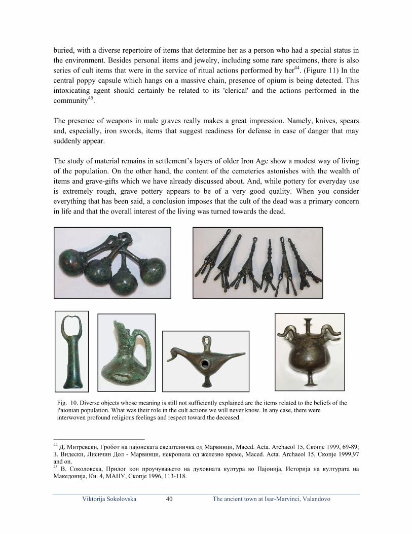
Viktorija Sokolovska 40 The ancient town at Isar-Marvinci, Valandovo
buried, with a diverse repertoire of items that determine her as a person who had a special status in the environment. Besides personal items and jewelry, including some rare specimens, there is also series of cult items that were in the service of ritual actions performed by her44. (Figure 11) In the central poppy capsule which hangs on a massive chain, presence of opium is being detected. This intoxicating agent should certainly be related to its 'clerical' and the actions performed in the community45. The presence of weapons in male graves really makes a great impression. Namely, knives, spears and, especially, iron swords, items that suggest readiness for defense in case of danger that may suddenly appear. The study of material remains in settlement’s layers of older Iron Age show a modest way of living of the population. On the other hand, the content of the cemeteries astonishes with the wealth of items and grave-gifts which we have already discussed about. And, while pottery for everyday use is extremely rough, grave pottery appears to be of a very good quality. When you consider everything that has been said, a conclusion imposes that the cult of the dead was a primary concern in life and that the overall interest of the living was turned towards the dead.
44 Д. Митревски, Гробот на пајонската свештеничка од Марвинци, Мaced. Acta. Archaeol 15, Скопје 1999, 69-89; З. Видески, Лисичин Дол - Марвинци, некропола од железно време, Мaced. Acta. Archaeol 15, Скопје 1999,97 and on. 45 В. Соколовска, Прилог кон проучувањето на духовната култура во Пајонија, Историја на културата на Македонија, Кн. 4, МАНУ, Скопје 1996, 113-118.
Fig. 10. Diverse objects whose meaning is still not sufficiently explained are the items related to the beliefs of the Paionian population. What was their role in the cult actions we will never know. In any case, there were interwoven profound religious feelings and respect toward the deceased.

Viktorija Sokolovska 41 The ancient town at Isar-Marvinci, Valandovo
The culture of the Iron Age in the lower Vardar Valley, which owed its prosperity to the use of mineral resources in the region and the developed metallurgy, suddenly faded. It occurs in the whole Paionian region, reaching far to the north. Events that occur in the meantime with the spread of the Macedonian state and the burst of the Persians, who are primarily thought of when seeking an answer to this question, can not be regarded as unique. The exhaustion in mineral resources would be another argument in solving this problem. It seems that Vardarski Rid, a settlement of this period, experienced its end as a result of floods that have affected it and put an end to life. Yet, the conviction remains that in that time some events took place, that we still can not capture. However, we are facing the end of an advanced culture with its own material and spiritual features, which will never be repeated. But, while the life in some settlements of the region completely faded away by the end of the Iron Age, as it was the case with Meleznik – Dedeli, the Isar, shortly after the slowdown in the Archaic period, experienced a new growth of the settlement. Inspired by the wave of settlers from the south who settled here in search of precious metals, for which there was a great demand, Doberos entered a new stage of cultural development, with a new orientation and different content. So, the highest plateau, where the acropolis was located, became the central position of the settlement. (Fig. 12). Its protective walls, built in the drywall technique during the Archaic period,
Fig. 11. An extremely rich repertoire of items is there in the tomb of the so called clerical. In addition to the jewelry and the items worn on her clothing, there is a series of cult items as requisites that were in the service of her profession and her role in the environment. The presence of opium in a poppy capsule, whose effect is well known since the ancient times, should certainly be linked to its use.

hiww
FefV Ta Aag
Vik
had the saminvestigatingwere found bwas coloniza
Fig. 12. Isar-Mearly antique ifeatures in the Vardar, to Idom
The oldest band as it see
As it seems,architecturalgrain produc
ktorija Sokolov
me role until g the excavaburials fromation of the
Marvinci- The at was colonizeregion. On its
mene. In the tim
buildings ceems, represen
, the oldest bl whole. Clacts were disc
vska
the end of tation squares
m the Iron Agacropolis at
acropolis-A towed by settlers frs slopes there ime of Filip II,
ertainly belonted as an ar
buildings thay bricks concovered in th
42
the pre-Roms, there werege. At this lethis time.
wn situated on rom the Hellenis the south acrthe town was a
nged to the rchitectural w
hat certainly ntinued to behe premises
The ancie
man period. Te noticed fouevel of explo
the highest planic south, who ropolis, througa part of Mace
residential whole.
belonged toe used as a syof those tim
ent town at Isa
The life wasur horizons
oration one c
ateau of Isar, inbring with the
gh which led thdonia.
facilities, se
o the residenystem of cones.
ar-Marvinci, Va
s at a very hof life. In so
can not speci
nhabited since emselves new che way to Glos
et the densel
ntial facilitiesnstruction. P
alandovo
high level. Wome places tify whether t
the Iron Age. cultural and sps-Grciste, and a
ly to each o
s, representePhytos for sto
While there there
In the iritual across
other,
ed an oring

Viktorija Sokolovska 43 The ancient town at Isar-Marvinci, Valandovo
Later, during the Classical period, there were buildings constructed of precisely laid stones. Then, the floor levels were made only of high-quality flooring bricks, and the roofing tiles were of exceptional quality, coated with red color that would provide protection from moisture. As far as it could be recognized, the orientation towards the inner fenced area implies the affiliation of the houses to the pastas house type, as is noticed in the excavations of Olynthus. In the destroyed horizons there were found fragments of stucco relief, which were the wall surfaces decorated with, at the same painted in red, blue and yellow. This horizon, with the exception of the ceramic material, is dated by a coin of King Amyntas III (398-383; 381-369), King Philip II (369-336), and King Alexander III (336-323) etc. During the third century BC, the lower sections of houses were built in stone and the upper - in clay bricks, but now for the first time we meet lime mortar which wall surfaces were plastered with. In the one of the rooms there is found a preserved floor made of gray mortar46. The Late-Hellenistic horizon is characterized with ceramic findings typical for this time, such as shallow bowls with low vertical brim, and ehinus made plates, lights from the so called, Macedonian type, spindle-shaped unguentaria, numerous Megarian bowls rich in decoration and quality, among which samples of Attic type were found. The mobile archaeological material, mostly the ceramics, follows the cultural horizons, often in small groups, under or over striking events of chronologically separate entities. The coins findings complement the picture of temporal affiliation of separate details. The Late Hellenistic-horizon of the acropolis is followed by coins of Antigonus Gonatas (277-239), Demetrius II (239-229), Philip V (220-179) and Perseus (179-168), and coins of Amphipolis, Pella and Thessalonika, forged from 187 to 31 year. The last phase of life on the investigated area shows that the acropolis was abandoned at a time and it was not used as a living space any more. Cultural layer filled with vessels in their full form, including an amphora fully preserved in fragments, then, part of a house with a channel in it, formed for flowing water and made of imbrices, is a picture of the last moments of life in the acropolis. In this layer, in Qu. 7 B and 7G, the inscription ‘stadium – roadmap’ was found, with the inscribed distance between Doberos and Idomene on it. However, researches on cemeteries give a clearer picture of the cultural level of the town in the pre-Roman era, as well as of the economic development of the settlement. During the classical period as well as during the Hellenistic period, burials were carried out in broad areas of southern and southwestern slopes of the acropolis. Occasional discoveries of individual graves showed that burials were carried out to a wider area around Isar. For example, a tomb was discovered in the village of Marvinci, on the main road, where among the discovered findings, there was a gilded diadem (with few golden leaves quite crushed), dated with the coins of Alexander III (336-323) and Antigonus Gonatas (277-239). According to the construction of the tomb, which is a classic example of construction from the Iron Age, it may be assumed that it was the secondary use of the burial chamber, an event which was usually met at the cemeteries.47 was the secondary use of the burial chamber, an event which was usually met at the cemeteries48. 46 В. Соколовска, Исар - Марвинци, 59 and on. 47 Ibid., 73, Fig. 56 48 Ibid., 73, Fig. 56

Ip
iic Igoc Tcpv
Felc
Ocace
pc Cwp
rl
4
Vik
It was the timperformed ifrom stoneimpression minto grave channel for
In some casgrave encloother casescremation.
The contencommon prperson, besivessels, whstrigilis, kniv
From the reemphasized lekythos-aribcantaros, ospecimens wfull length oOften therecontainers, appeared, sucraters withexamples mstyle of red pottery charclassical era
Certain examworkshops, parts, but hostyle of blacrare. In 20lekythos wisize.
49 Ibid., Т. II-V
ktorija Sokolov
me when crento freely d and broumake those gpits, with
air circulatio
ses crematiosures, which
s, articles w
nt of the gractice. Depides the jewile in the mves or spear
epertoire of some whi
balos with ooinohoi, skywith painted or only femae were mo
oinohoi auch as pelikh a display
mostly belongfigures on
racteristic fa49. (Fig. 13)
mples beloncrafted by
orrendously ck figures o09, in a buith drawings
V.
vska
emation appdug burrowsught by negraves wherepreviously
on.
on was perfoh caused dewere somet
grave artifaending on twelry there men’s graves.
the ceramicich were vor without dyphos, amoimages of m
ale charactersonochrome and others.kes, with repy of mythg to the anciblack base,
for the Gree
ng to the promaster cramore inferi
n a red backurial were s of mythol
44
peared as a tys or in strucwcomers. Re cremation along them
formed togeteformation otimes applie
acts coincidthe assets owere also
es there cou
c vessels, thvery commodecoration, mong which
men and woms in profile iplates, so
Exceptionpresentation hological scent products manner of ek vase pai
oducts of Aeaftsmen settior quality. kground wefound first
logical figur
The ancie
ype of burialtures formedReally greais performed
m excavated
ther with thof objects. Ined after th
des with thof the buriedlaid cerami
uld be found
here could bon, such amonochrom
are foundmen shown inin close plan
called salnal findingof graphs o
cenes. Thess made in thf painting thinting of th
egean potterytled in thesVases in th
ere extremelysamples o
res, small in
ent town at Isa
l, d at d d
he n e
he d c d
e as e d n
n. lt
gs or e e e e
y e e y
of n
Fig.13. Tof black mark toantique. found incolonistswere macame to I
ar-Marvinci, Va
The Greek vasand red figures
o the classicaVases of this
n the tombs os. Fine samplesde in OlynthosIsar-Marvinci.
alandovo
se painting in s provides a unal period in style were m
of the new ses in a unique s, from where
style nique
the ostly
ettled style they

F
ucuTifo Fhhr
mut
5
Vik
Fig. 14. Stagessubtlety and unsurpassed pcharacters on unable to see The monumeinfluence. It cfrom the townobject dating f
Fig.15. A tomhonor of a youhis chest- armright hand. Thsuggests the dmentions that unveiled in 19the military ca
50 Ibid., Т.39,1
ktorija Sokolov
s of separationexpression
erfection in thour monumethe expression
ent was madccertainly belonn of Isar. It wafrom the last sta
mbstone in the ung man-warr
mor, helmet onhe display of a deceased to ha
his name is 961 in the debrastrum.
.
vska
n shown on graof restraine
he art of classient are missinn of the reprede under thenged to a dist
as found as spoage of Isar.
form of naiskrior, shown in n his head and
snake, as a chave been a heZoilos. The m
ris from of the
45
avestones in ited grief arecal epoch. The
ng, making uesented persone Alexandriantinguished ladyolia, built-in an
kos, erected ina full gear: on
d a spear in hihthonic symbolero. The articlemonument wae ruined wall o
The ancie
s e e
us n. n y n
n n s l, e s
of
ent town at Isa
They precefigural stypresence ofcentury BCdead we dthat at buriawere laid, purposes, nreligious bereflection olost personwhich thedepicting tha high sodiphros, accbrings the f(Fig. 14)
ar-Marvinci, Va
ede the vayle which f this kind o
C. What was o not knowal of relative
items intenot only in eliefs of theof love and n. This is ae big stelhe diseased –ociety sittincompanied bfan and jewe
alandovo
ases of thespeaks of
f import in tthe status o
w. But we kes, valuable ended for the spirit oe time, but
sadness foralso the timle belongs – a woman
ng on a cby a servant elry box to h
red f the the 5
of the know gifts such f the as a
r the me to
to, from
chair-who
her50.

Tmn
m
bpc D
tdtbiobrw Fdtdpao
a
QwTtho 5
5
Vik
This tombstmarking thenot so numefor us. That monument tsoldier withbe assumed primary rolconstruction
During the 4spiritual cultheir religioudominant cuthe new unbrought theiintegral partof Apollo asbegan. (Fig.respected alowhere certai
Fig. 16. Sincedeity which exthat is born andeity Cybele. people on the animals, lions,of the iconogrshown statuettacolytes.
Quite notabwoman in hThat being thrown overholding an oof Aphrodite
51 Ibid., Т.39,352 В.Соколовс
ktorija Sokolov
tone testifiee graves, buerous. Anothis a small to
takes form h Macedonia
that with thle, they wen of new faci
4th century ture of the pus views andult in the prnderstandingir own deitiet of their beins a deity of li. 16). This fong the Vardinly existed a
e the Neolithicxpresses intimand develops on Its origin is linmountain peak, harnessed to traphic represetes of Cybele
ble set is theheight abovea depiction r the head wobject in her e, were laid
3 and 4, T.40, Tска, Исар Мар
vska
es the existeut their preseher tombstoombstone ofof a temple
an shield in e course of t
ere secondarilities.
BC, there cpopulation ad beliefs. Threvious periogs influencees with themng and theiright, the domfemale deitydar Valley, ea shrine ded
c Age in our rate feelings of m
earth. This idenked to Asia Mks by practicinthe chariot of C
entation of thefrom Isar-Ma
e one of tome the hips. A
of a young with a hood
hands: an ain the grave
T.34,1 and 2, Ввинци, Т. 14,
46
ence of comence on the
one is of spef Zoilos, sone - naiskos,his hand (Fthe time, whry used as
came to majoand the way he appreciatiod was bein
ed by the nmselves as ther cultural lifemination of ty seems to hespecially in
dicated to her
region is beingmen to the Motea is included Minor, where ing the rites of hCybele will bee goddess. In arvinci, accom
mbs, where All, so far di
woman dreon it, on so
apple, bird ors as t as a pe
В.Битраква Гро1-3; 19,1-4.
The ancie
mmon practiresearch fie
ecial significn of Isholaos, which shoig. 15). It sh
hen they loststone block
or changes iof demonstron of the sunng suppressenewcomers, ey represente. Despite ththe cult of Chave been wn the town Dr51.
g respected a ther of Nature in the cult of oit is respectedher cult. Her fcome an integrthat spirit, the
mpanied by lio
terracotta feiscovered spessed in a chome specimer another. Thersonification
озданова, За в
ent town at Isa
ce of eld is cance s. The ows a hould t their ks in
in the rating n as a ed by
who ted an e cult ybele
widely Dober,
female and all
oriental by the
favorite ral part ere are ns and
female figuripecimens arehiton with Vens being quhese pieces on of eternal y
верувањата по
ar-Marvinci, Va
ines were foe similar in tV-expressionuite lavish. Tof terracottayouth (Fig.
о долината на
alandovo
ound, showitheir concepn, with himThe woman
a with a depi17).52
Вардар.
ing a ption. ation
n was ction

Viktorija Sokolovska 47 The ancient town at Isar-Marvinci, Valandovo
Fig.17. Such terracotta figurinees of the goddess Aphrodite or another, are often placed inside the tombs of young women and girls. Objects that they often hold in hands-apples, birds, etc., symbolize the fragility of life and early departure from this world.
After this significant prosperity in the middle decades of the 3rd century BC, we are faced with a lack of findings which can be attributed to this time. It is a period of depopulation of cities caused by the desolation of the Celts who, as known, passed through the Vardar Valley on their way to Delphi. This phenomenon has long been observed by studying the ancient sculpture in Macedonia53.
Fig. 18. An iron helmet discovered into the tomb No.50. This is the only finding which remained in the tomb after its looting. It certainly belonged to a prominent warrior But in the last decades of the 3rd century BC, a new wave of settlers took place in the towns at the Vardar Valley region. This event is attributed to Philip V and his policy of recovering of the impoverished towns in Macedonia and their resettlement, which is archaeologically multisided verified. Doberos maintained its constant intensity. The cultural layers in the settlement abound with findings of pottery typical for that time, especially the presence of coin findings. However, the cemeteries, with their content, give a most vivid picture of the economic situation of the city and its prosperity. 53 В. Соколовска, Античка скулптура во СР Македонија, Скопје 1987, 87.

Tl
ew
Fnt Tatpdpgioaok
Vik
The burials ulargely shorso far, helpeevent in ourwhich have finding arou
Fig.19. Apart fnew techniquetopics: figures
The burials and jewelerythe so callepurposes. Odecorated wplaced top hgray clay. Tin preparatioofferings, inalso should of lamps whknown as M
ktorija Sokolov
used to be crtened us in ed us to formr communityremained in
used the inter
from the previe, so called mos from Homer's
were conducy. In the reped Macedon
On the surfawith the colhandles and his phenomeon of a gray n spindle formbe mentione
hich belong tMegarian bow
vska
onducted ongaining bettm a picture
y, because it n the grave urest of the ne
ous epoch wheolding, by whics epics, mythol
cted largely pertoire of thnian type, wace, they weored ribbonlid, are oftenenon, also prpottery by am. They comed the platesto the Mace
wls, are also
48
n the south anter knowledgof this periis an extrem
unnoticed byeighboring c
en the ceramicch the Megaralogical scenes
by inhumatihe pottery thewhich emergere made ofns. Stamnos n seen as a sresent in othapplying a spme in red –a in differentdonian typefound occas
The ancie
nd south-wege of our citod. The disc
mely rare spey modern (pecountries. (F
c vessels werea cups were maor actors and d
ion. Grave aere are frequged as burif fine ochre
pyxis, bellspecial kind her containerpecial methoand- yellow t forms and v. The reliefs
sionally as bu
ent town at Isa
estern cemetety, everythincovery of anecimen of therhaps ancienig. 18)
made on stakeade, where in dancers.
artifacts consuently foundial offeringse clay, on thy-like vesseof grave po
rs, speaks ofod. Ungventor gray clayvarieties, as s of the plateurial articles
ar-Marvinci, Va
ery. Althougng discoveren iron helmehis kind of mnt) robbers.
es, in the Hellea relief were r
sist mostly od minor pottes made spehe shoulderels with verottery. They f the traditiontaria are freqy. Among thewell as the o
es, made by s. (Fig.19)
alandovo
gh illegal diged by the exet is well kn
military requThis except
enistic period arepresented a v
of pottery, teery amphora
ecifically forrs or abdomrtical or diawere often mn of local craquently foune other formoccasional pmolding, ot
gging xperts nown uisite, ional
appears a variety of
erracotta as from, r burial
men was agonally made in aftsmen
nd burial ms, there presence therwise

GpptWdvh
weoe Fppf
Vik
Grave artifaproduction, phenomenonthere were fWe come adifferent apvessels withorizontal rsimple bottowhich the beasier raisinof the lid, orelements typ
Fig. 20. Theseperiod in Macpopulation. Hefemale’s tomb
ktorija Sokolov
acts greatlythe styles
n is highly efound pyxsiacross thempproach to oth additionaing which som ring thabox stands,
ng, and finallr vegetative pical of these
e nice jewelrycedonia are there, at Isar, has.
vska
y complemeand fashion
expressed indes, boxes i
m in variousornamentatioal functionshould serveat could be
the ring-shly an additioornaments p
e very nice i
y boxes that gihe mere reflecave been disco
49
ent the imans of a spe
n our countryintended fors size, diffeon. This typ
nal elemente as a suppo
replaced byhaped lid thonal relief appainted withitems. (Fig. 2
ive a distinctivctions of the cvered in a vas
The ancie
ge of craftecific time. y. In many tr storing jewerent qualitype of cylinds, such as
ort to the lidy lion's paw
hat serves foapplication oh white colo20)
ve mark of Hecivilized part st number as g
FwcqgsrC
ent town at Isa
tsmen This
ombs welry. y and drical s the d, the ws on or its
on top or, are
ellenic of the
gifts in
Fig. 21. Terrawidespread acoroplasts. Thqualities attaigraceful figurestyle. Their styreflection and rClassical and H
ar-Marvinci, Va
cotta as buriaactivity of
his subtle crafined perfecties of women, yle bears featureplacement of
Hellenistic era.
alandovo
al offerings, shthe Maced
ft with real aion in displ
made in a reures of its timef the great art
how a donian artistic laying efined e as a of the

Viktorija Sokolovska 50 The ancient town at Isar-Marvinci, Valandovo
Terracotta, as a common burial offering of that time, and crafted by local craftsmen, show a widespread activity of the Macedonian coroplasts. This subtle craft with a note of true art, reached in Macedonia perfection in displaying graceful figures of women and various deities presented in refined style. The repertoire of characters reflected the current local fashion, by which we can see the refined taste of consumers as well as of craftsmen who did it. (Fig. 21) In the category of grave findings, jewelry takes a prominent place not only for the value and the glitter of gold, but for the artistry of workmanship that has reached perfection. The most frequent are the earrings in a form of lion’s protome, a motif that had a long tradition in the Macedonian goldsmiths. Earrings in the shape of birds, sometimes with embedded garnet, have an exceptionally elegant form. Beside these teriomorfe samples, there are earrings with black heads, while as rather favorite earrings appear those with a figure of Eros. (Fig. 22)
Fig. 22. The Halkidikian goldsmithing, which ever since the archaic period (to which the cemeteries Sindos and Trebenista belong) dominates in the toreutics on the Aegean coast, continuing to make jewelry with top quality. The technique of filigree and granulation as well as the use of semiprecious stones comes to the fore of the jewelry discovered as grave content of the cemeteries in Isar – Marvinci. As dominant ones appear the earrings in the shape of a dove, lion’s protomes, Eros, or Negroid heads, an exquisite fashion wave in the Hellenic period in Macedonia.
The subjugation of Macedonia under the Romans, and the turbulent times followed by tumultuous events in the kingdom, had to be reflected in our cities. The new rulers, the new policies and the new settlers had to make changes in the
life of the Macedonian towns in the Vardar Valley. From an archaeological point of view, life can be monitored continuously, perhaps in more modest scale, but it becomes clear that in the period of transition from the old in the new era, also comes to transition of the material culture that reflects these changes. Cremation was being practiced once again. In the burials there emerged different ceramic forms, without lights, but terracotta were still favorites as burial offerings. The tombs dug deeply into a rock, with dromos, the atrium and ventricles, common in the previous period, were still in use. The modest burials with the cremated remains were collected in urns and directly laid into the ground. The burial offerings were also modest: cups, plates, Bulbus ungventaria and sometimes a gold earring in the shape of circular curved wire. But, Doberos soon became a town settled by Romans, who were retired soldiers joined in their convents. This event was epigraphically attested: “The town and the convent of settled Romans, pays tribute to Publius Memij regulate who was legatus Augusti pro praetore in the united provinces

Viktorija Sokolovska 51 The ancient town at Isar-Marvinci, Valandovo
of Achaia, Macedonia and Moesia from 35 to 44, for his merits.” It is its content54. This article proves that Doberos already played a role of a significant town in the Vardar Valley region, in the first century AD. Archaeological material, mainly made of ceramics, discovered in the cultural strata of Sector I, and micro locations where excavations were conducted, as well as surface observations, said that at this time have maintained contacts with the Aegean coastal centers, from where came to an expensive tableware ceramics. It is worth mentioning in the first place the Pergamon ceramics, known as Eastern sigilata which occurs at Isar in a limited repertoire. During the first century, while in the west, the Italic workshops of the famous terrasigillata were flourishing, to the east occured pottery known as samian or eastern sigillata A. Its refined quality in slip and its orange glaze sorted it in the group of particularly valuable and expensive ceramics. The early imperial monochrom ceramics, decorated in technique barbotin, belongs also to the first century. These are just some examples of luxury tableware ceramics, which occurs at Isar as a result of the economic growth of the city and the citizens who could afford purchasing it. Doberos reached its zenith of development as a city in province of Macedonia during the early imperial period. Historical events in which participated and construction activity which at that time were going on, raised this town to a level at which some other towns in Macedonia were. Fig. 23. In this state was the temple discovered in the 80's of the 20th century. And then it was clear that throughout its existence it experienced several repairs and renewals, to eventually serve as a stone quarry, whose blocks are built into the later facilities. Certain elements that are gradually being revealed with the excavations in the town, reinforce the conviction that even during the first century, in Doberos began the building a solid public buildings. During the first or early second century these objects probably suffered from a natural disaster, certainly by an earthquake that collapsed all previously constructed facilities. Some of them were at the area of Sector I, i.e. near the temple, others to other locations on the Isar. The phase of recovery of the city began just after this disaster. At that time the city baths were built, with basically used the elements of an older building, fur which, at this stage of exploration we can not be sure what exactly it was. A series of four massive connectors (about
54 Б. Јосифовска, База са посветом П. Мемију Регулу, Ж. А. IX, 1959, 285 and on. Fig. 3 and 4; В. Соколов-ска, Исар - Марвинци, 131; С. Бабамова, Епиграфски споменици од Македонија датирани според македонската провинциска

Viktorija Sokolovska 52 The ancient town at Isar-Marvinci, Valandovo
100x100 c m) set in the direction northeast - southwest against the main facade of the temple, speaks of a massive object, possibly stoa or porch that belonged to another object with different purpose or it was in a function of thermal spas. Then comes to restoration of the temple, so that the year 181, mentioned at the architrave, should be understood as a time when the temple was rebuilt. The original temple, as it seems, had a different conception and probably was a more modest facility. With the renewal it received a form of tetrastilos prostilos with massive architrave, at which is preserved an incomplete inscription:
........μακεδονιαρχϖν τον ναον τη πατριδι
........ν παντι τω κοσμω Θ κ τ ετει Unfortunately, the front part of the text, where should be noted the name of the donor is missing. 55 (Fig. 23, Fig. 24, Fig. 25)
(Fig. 24, Fig. 25) These are residues (with a partial reconstruction) of a temple for which we know that was built or renovated by one Makedoniarh, a member of the Macedonian Koinon with seat in Beroia, who originates from our town of Isar. The date of the inscription preserved of the architrave, 181 year, coincides with the reign of the Roman Emperor Commodus. When the town of Isar got drastically demolished, its further fate got uncertain. When later the surrounding area was turned into a military camp, it was used in a profane purpose. The construction or restoration of thermal spas lasted until the middle decades of the second century (161 year) suggested by the contents of the inscription with which a tribute is paid to Marcus
55 Б. Јосифовска, Грчки натпис са архитрава једног храма; В. Соколовска, Исар - Марвинци, 100 and on. Fig. 64-69; С. Бабамова, Епиграфски споменици, 102, но. 29

Aibce
i
winct
ADit
5
т
Vik
Aurelius Dein the inscribaths. 'The constructionexperiencedSupplying thinterventionfor the variowe read at Limportance5
not lag behichannel wasthe residenti
At the sameDoberos durindications town lives
56 Ц. Крстевскта Македони
ktorija Sokolov
emocrat for biption, was b
culture of n in the citiesd serious cohe baths wi
n. The importous steps unLaura Bofo,
6. We refer ind the othes built for suial objects st
e time, in 1ring the earlsuggest thatwith maint
ки - Лаура Боија, Folia Arch
vska
building the brought fromthe baths',
s of the Empompetition ath water watance of the dertaken by who has inteto this quot
er prominenupplying witrung along t
81, the temly- imperial t there wereaining its c
офо, Градот haeologica Bal
53
canal to supm natural so which fropire, could oat the consas a particulepigraphic dthe town to
erpreted andte in order tont Macedoniith water thethe terrace.
F
mple was rebperiod, we
e solid objecconstant inte
на Исар - Мkanica, Скопје
The ancie
pply water toources to them the seco
only happen struction fielarly good wdocument ofo fund the md published to understandan towns. M
e neighborin
Fig. 25
built by makdo not know
cts and multensity. The
Марвинци и е 2006, and on
ent town at Isa
o the city bae facilities wond century in a city tha
eld between work, which f Isar is that
most importanthis epigraphd the importMost likely, ng terrace of
kedoniarh. Ww on this detiple locatiopraetorians
римската адn., Fig. 4.
ar-Marvinci, Va
ath. The watwith frigidar
began to at already ha
major towrequired a
it refers to ant of its builhic monumentance of Dobthat was he
f Sector VII
What facilitiegree of expns on Isar.
s, for whom
дминистрација
alandovo
ter, as mentirium of the characterize
ad a traditionwns in the
special finaa series of 'calding venturnt of exceptberos, whiche time when, which supp
ies were buiploration. CeIn any case
m we know
а во провин
ioned local
e the n and area.
ancial anon' res ... ional h did n the plied
ilt in ertain e, the
that
нција-

Viktorija Sokolovska 54 The ancient town at Isar-Marvinci, Valandovo
originated from Doberos, got fired. At the time of Septimius Severus and Caracalla our town communicated with the Roman imperial administration in connection with problems it was facing with, as the import of wheat from Libya. The inscription is dated in the 228, which according to the actisian era corresponds to 197.57 This means the town lived intensely and for solving its problems it maintained connection with the Rome. The transition from the old to the new era was largely manifested with the burials in urns. At this time, the northeastern foot of the Isar was used - the slopes around Janova Cesma, where locals often run up in urns, each with a modest offering - ungventarium bulbus or cups with one handle. During the following centuries of the early imperial period, burials were performed on a ridgeline that extends just behind the central part of town. Here, as it seems, the burials were carried out roughly from the 1st - 4th century. Judging by the construction of tombs - built and plastered graves dug deeply in the rock, with formwork marble slabs, with staircases and paginal floor –it was a burial site for the most prominent inhabitants of Dober. Unfortunately, we do not know the contents of their graves, as they were robbed in antiquity. In this way, we are deprived of important information on the economic position and status of these people. But, at this part of the cemetery there is an array of types of tombs that reflect the time they occurred, the grave architecture, the ritual applied in certain periods, even the ethnicity of the buried people, which speaks about the characteristics of newcomers as opposed to domestic indigenous population. Moreover, their content speaks to the economic status of individuals, sometimes their profession as a substitute for the richest burials robbed in antiquity58. This, as it seems, welfare will be interrupted in 267, when a large group of Goths who had previously devastated Athens and then unsuccessfully besieged Thessaloniki, on their way to the north they devastated Doberos and Pelagonia. Zosim, who noted this event, did not specify any more details. Regardless, we come across the beginning of late antiquity in our region, with a ruinous and neglected town. The same fate suffered Stibera, a distinctively progressive town in Roman times, which after this event never recovered59. The location of Doberos in the valley of the river Axios, by the main highway, and the configuration of the terrain of its location, proved to be an extremely convenient place to raise military castrum, built later. Its position wholly suited to the objectives for which it was built, having in mind the great view over the valley and the roads to the south and to the north. Then the space around the temple and the city baths was surrounded by massive walls and were built spacious towers of the four corners60. As it was pointed out a number of times, in the walls were built in building elements from demolished buildings - bases, capitals, tombstones, statues and pieces of statues, porches, stairs of objects and many other items, indicating that the primary goal was raising of the castrum by the cost of neglecting everything that was created before.
57 Ibidem, 346 and on., Fig. 5. 58 В. Соколовска, Исар - Марвинци, Т. 46-47. 59 В. Соколовска, Античка скулптура 60 В. Соколовска, Исар - Марвинци, 98, Fig. 58-63.

Viktorija Sokolovska 55 The ancient town at Isar-Marvinci, Valandovo
According to some opinions, castrum was built in the time of the conflict between Constantine and Licinius, in the period from 312 to 324, when there were lifted other castra in the region. Mikulcic considered that castrum as such did not serve for a long time for its primer use. After a short time, the military left it and settled civilians instead61. The situation on the ground fully coincides with this opinion. The attitude of the inhabitants, towards everything that was previously created, completely changed. The nature and purpose of the existing facilities were no longer respected. Thermes might have retained their purpose, but the temple already lost its role. Their premises were used as a basic living space. The role of the destroyed temple got a prosaic purpose. Its massive architectural blocks - architrave, parts of the crown with denticles, ionic bases and capitals of columns, were embedded in the walls of houses as an ordinary building stone. In front of the stairs leading to the temple, there was erected an object where pithoi with charred grain were found. In his fundamental parties was built a statue of our Lady of Doberos. We do not know exactly when, but we know that in this period, during the fourth and fifth century, arose houses one after another houses, for accommodation the population without respecting any previous plan. Near the entrance to the city bath, there was a facility where the pithos was found, which is now kept in ‘The House of Yought 25 May’,in Valandovo. The objects, with which was fulfilled the castrum, were built in a dry-wall technique, i.e. by stone connected with the clay, which is a modest and rapid technique of constructing. The inhabitants of the town did not seem to have had any intention or attempt to rebuild the ruined buildings, or renew something else. Burials which belong to the fourth century show the presence of newcomers - Goths, Sarmates, which at the time of in Constantine settled in the Balkan provinces. However, regardless of the situation, the town was still alive. The coins of Constantius (337-361), Jovian (363-364), Valentinianus (364-375), Valens (364-378) and Gracijanus (367-383) discovered in the tombs, are evidence that Doberos yet intensely lived in the late fourth century62.With the latest excavations of the area that encompasses Sector I, near to the tample, in the cultural horizon of the period that marks the of life of Doberos, where the most impressive premises are built of stone and mud, in which in situ were discovered several pythoi for storing grain food, there was discovered a hoard with coins scattered on an area of 2 m 2. Among the coins (85 in number) the better preserved ones are the so called small bronzes of: Constantine the Great (306-337), Arcadius (339-408), Honorius (384-423), Marcianus (392-457), Theodosius II (401-450). This finding is undisputed evidence of life in the city of Isar, during the 4th and throu the 5th century, what is in accordance with the pottery of that time. It is difficult to accurately determine the time of its end. Whether it later experienced another catastrophic destruction due to earthquake, we do not know. Future excavations of space around the castrum will certainly give more detailed elements as answer to this question. But at this point we could say that life in Doberos was not suddenly interrupted. Some characteristic findings indicate that during the fifth century people there continued to live, although in horrendously modest scale.63 And, the not very remote town Stobi suffered great devastation with intrusion of Goths. But soon 61 И. Микулчиќ, Антички градови во Македонија, 262. 62 В. Соколовска, Исар - Марвинци, 136, 137. 63 Ibid., Т. 50, Fig. 17; Т. 87, Fig. 11 and Fig. 12.

Viktorija Sokolovska 56 The ancient town at Isar-Marvinci, Valandovo
Stobi strengthened itself amd the old city ruins appeared in a new urban image. Apparently, Doberos had no such economic power to accept the challenges of modern times. At this time, a phenomenon occurs which in this occasion should be emphasized. Just in the time when Doberos was declining, the town located on the territory of present Valandovo experienced impressive growth and blooming. Under the foundations of several houses in the town, there were discovered objects with floor mosaics which, according to the style of decoration, belonged to the end of the fourth or early fifth century. Near the space of the so called Stakina Cesma, there is discovered late antique house, again with floor mosaics64. Not far from it, there were found parts of pillars which belonged to a monumental building. All this makes us think that under the present Valandovo lay the remains of an ancient settlement where in the late antique was built a lavish temple complex with basilicas and other supporting facilities. This coincides with the time when the old basilica was erected in Stobi, as well as the first basilicas in Bargala and Scupi. In our region, during the 5th century begins the construction of basilicas in the populated areas - in Brajkovci, Bogdanci, in Nikolic, and other modest basilicas arose as a consequence of the acceptance of Christianity as a state religion, when in large cities in Macedonia (Stobi, Heraclea, Lychnidos) were built sumptuous episcopal basilica, as centers of the regions. In our region was established an ecclesiastical complex which as a seat of the bishop Eusebius, who is known to be a signatory to the Halkedonian council in 449 year, recorded as the bishop of the Doberian area of the Macedonia Prima.65 We should ask ourselves why at Isar in Marvinci were not built luxury buildings and basilicas of this kind, when we know that Doberos had always been a central settlement in the region. Perhaps the hilly configuration of Isar did not permit this to happen, and swampy parts of the field at the base did not allow the town to expand in that direction. Therefore, the slight slope on which today lies Valandovo, withdrawn from the riverbed of Bojmica, was suitable for construction of urban settlement of this kind where an ecclesiastical center was established, that at the same time, had a strong fortress behind itself, providing protection at a given moment. But despite that, Doberos had not lost its importance in the region which it had for more than 1000 years. The region, known in the historical sources as Doberian area, was still recognized as such. Let us recall the data in Strabo, (VII, frg. 36), where the area of Doberos was mentioned, which extended to the left of the road, leading from Heraclea to the gorge of the river Strymon. Therefore Eusebius is designated as Doberian Bishop of the First Macedonia. The walls of the castle with its strongly built towers certainly had a long-lasting lifetime. We will meet them once again used for the same purpose, to which refers the coin of Isac Angel (1185-1195), discovered at Sector 1, with the first excavation of Qu.K15.66
64 See ref. 20 65 According to: Ф. Папазоглу, Македонски градови, 252 with ref. 104. At Isar-Marvinci there are found coins from the 6th century. 66 В. Соколовска, Исар - Марвинци, 148, Т. 55, 31

Viktorija Sokolovska 57 The ancient town at Isar-Marvinci, Valandovo
APPENDIX Recently, at the Roman cemetery of Isar - Marvinci was discovered a marble slab in secondary use, on top of the grave 1905. In the inscribed field framed by a double profilation, a text in Greek is precisely carved. The text mentions that Mark Tetij Rufus erected a statue of Heracles and the temple of the city from its own funds. The inscription is dated in 227 year, which according to the Macedonian era, is 79. (The article was published in: Ц . Крстевски, Добер, Античкиот град на Исар - Марвинци, in press). Without doubt, we are now able to conclude that it is the same temple that after demolition was restored by our Makedoniarh in 181 AD. With this extremely valuable information it is confirmed that the town of Isar, between these two dates - 79 and 181 - suffered a strong earthquake, so that later, at the end of the second century, to be restored. Then, despite the restoration of the temple, there were built a city bath and other public buildings, whose architectural parts, after the fall of the Goths were embedded in the walls of the castrum and in the late antique secular buildings.

Viktorija Sokolovska 58 The ancient town at Isar-Marvinci, Valandovo
BIBLIOGRAPHY FOR THE LOWER VARDAR VALLEY
Бабамова, С. - Епиграфски споменици од Република Македонија датирани според македонската провин-циска ера, Скопје 2005, Но. 27, 28, 29, 80, 81, 82, 83.
Битракова Грозданова В. - Хеленистички споменици во СР Македонија, Скопје 1989; - За верувањата во антиката по Долината на Вардар, Историја на културата на Македонија, Кн. 1, Скопје 1995, 119-127; - Скулптурата од Вардарски Рид, Вардарски Рид Том I, 289-304. - Прилог за култот кон ZEYƩ YΨIƩTOƩ во Македонија, Živa Antika, 56, Скопје 2006, 73-80 Блажевска С. - Сектор Акропола, Истражување 1999-2000, Вардарски Рид Том I, 209-227; - Печки за керамика, Вардарски Рид Том I, 261-280; - Минијатурни медицински садови, Вардарски Рид Том I, 305-313. - Акрополата на Глоска Чука, Мaced. Acta. Archaeol. Но. 19, Скопје 2010, 193-208. Драгојевиќ Јосифовска Б. - Грчки натпис со сигнатура на Уметникот Адимос, ЖА VIII, 2, 1958, 295-300; - База са посветом П. Мемију Регулу, ЖА IX, 1-2, 1959, 285-290; - Грчки натпис са архитрава јегног храма из села Марвинаца, ЖА XV, 1, 1966,137-147. - Известај о археолошком ископавању код села Марвинаца, - Годишен зборник ФФ, Скопје
1967, 317-352; - Депо фолеси од с. Марвинци, Годишен зборник ФФ 22,1970, 353-372; - Извештај за археолошкото рекогносцирање по долината на среден Вардар, ЗАМ IV-V, Скопје
1974, 107-113; - База са посветом Марку Аурелију, ЖА 33/1, Скопје 1983, 23-25. Dukal Z.-Mirnik I. - Skupni nalaz makedonskog bronzanog novca iz Dojrana, Numizmaticke vjesti,1986,44-49. Gaebler, H. - Die Antiken Munzen fon Makedonia und Paionia, Berlin 1935. Георгиев, З. - Карактерот и значењето на вонгробните наоди во јужно-повардарските некрополи од же-лезното време, Maced. acta archaeol. 6, 1980, 37-54;
- Елементи на раната антика во Долното Повардарје, ГЗФф 2, Скопје 1984, 51-85; - Рачно изработуваната керамика од долноповардарските некрополи, Maced. acta archaeol. 9,
1988, 65-81. Герасимовска Д., - Антички куќи во Македонија, Скопје 1996.

Viktorija Sokolovska 59 The ancient town at Isar-Marvinci, Valandovo
Јованов М. - Бронзени садови од Вардарски Рид, Вардарски Рид Том I, 281-288; - Крајот на животот на Вардарски Рид, Вардарски Рид, Том I, 315-322. Hammond N.G.L. - A History of Macedonia, Vol. I, Oxford 1972. Хусеновски Б.-Спасовска-Димитриоска Г., -“Вардарски Рид”-Гевгелија, Истражувања во 1994 година, Maced. acta archaeol. 15, Скопје
1999, 157-182. Хусеновски Б. - Сребрен статер од типот “Кентаур-Нимфа”, Примерок од нумизматичкиот фонд на лок. Вардарски Рид, Мекедонско наследство бр. 18, Скопје 2002, 75-80;
- Античките монети од Вардарски Рид, Гевгелија 2004; - Депо на сребрени тетрадрахми од III в. пр.н.е., Вардарски Рид Том I, 323-345; - Милци 1997, Заштитно ископување, Maced. acta archaeol. 16, Скопје 2005, 89-118. Ивановски М. - Керамички печати из Марвинаца код Валандова, VESTIGATIO VETUSTATIS, (Посветен на А. - Цермановиќ-Кузмановиќ) Београд 1999, 199-207.
- Златен накит од Марвинци, FOLIA ARCHAEOLOGICA BALKANICA (In Honorem Verae Bitrakova Grozdanova) Скопје 2006, 171-184.
Карпузова С. - Куќа со колци, Вардарски Рид Том I, 179-207. Кацаров Г. - Пеонија. Принос кьм старата етнография и история на Македония, София 1921. Крстевски Ц.-Л. Бофо, - Градот на Исар-Марвинци и римската администрација во провинцијата Македонија, FOLIA
ARCHAEOLOGICA BALKANICA (In Honorem Verae Bitrakova Grozdanova) Скопје 2006, 333-355.
Лилчиќ В., Јосифовски П. - Сребрен диобол на пајонскиот владетел TEYTAOS, Maced. Num. Jour. 1, Skopje 1994, 27-37. Merker I. - The Kingdom of Paionia, BS 6, 1965, 35-54. Микулчиќ Г. - Хеленистичка гробница од Марвинци, Културно наследство XII-XIII, Скопје 1988, 71-75. Микулчиќ Г.-Карапетков Г. - Марвинци 1994, Некропола, Maced. acta archaeol. 14, Скопје 1996, 67-75. Mikulcic I.

Viktorija Sokolovska 60 The ancient town at Isar-Marvinci, Valandovo
- Pelagonija u svetlosti arheoloskih nalaza,Beograd 1966. - Накит класичног доба из Демир Капије, Старинар н.с. Београд 1970, 135-138. - Скопје со околните тврдини, Скопје 1982; - Хеленистички тврдини во Демир Капија и Бабуна, ГЗФФ 34, Скопје 1982, 127-143; - Топографија на Стенае-Просек-Демир Капија, ГЗФФ 41-42, Скопје 1988-1989, 65-88. - Антички градови во Македонија, МАНУ, Скопје 1999. Микулчиќ И.-Соколовска В. - Гробница во Бразда кај Скопје, Maced. acta archaeol. 11, Скопје, 1990, 79-92. Митревски, Д. - Карактеристични форми на македонски бронзи од наоѓалиштата по долината на Вардар,
Maced. acta archaeol. 9, Скопје 1988, 83-102; - Дедели, некропола од железно време во Долно Повардарје, Скопје 1991; - Прилог кон познавањето на Долновардарската - пајонска група на железното време, Maced. Acta archaeol.12, Скопје 1992, 145-161;
- Гробот на Пајонската свештеничка од Марвинци, Maced. acta archaeol. 15, Скопје 1999, 69-89; - Вардарски Рид, Истражувања 1995-2004, Вардарски Рид, Том I, 15-90; - Куќата на колек-ционерот, Вардарски Рид, Том I, 229-259.
- Археолошки истражувања на Глоска Чука - Грчиште кај Валандово, Мaced. Acta. Archaeol. Но. 19, Скопје 2010, 127-146.
Митревски Д., Темов С., - Нови наоди од Исар-Марвинци - Истражувања во 1997 година, Сонда I, Maced. acta archaeol.
15, Скопје 1999, 135-156. Папазовска А., - Слоеви од железното време на Вардарски Рид, Вардарски Рид Том I, 115-157. Папазоглу Ф. - Македонски градови у римско доба, Скопље 1957; - Srednjebalkanska plemena u predrimsko doba, Sarajevo 1996. Пачкова Куфојанакис Б. - Архитектонско-градежни материјали и елементи на античката населба на Вардарски Рид, Вардарски Рид Том I, 347-372.
Пашиќ, Р. - Археолошки истражувања на локалитетот Сува Река во Гевгелија, Maced. acta archaeol. 3,
1977, 43-56; - Археолошки испитувања на локалитетот Сува Река во Гевгелија, Зборник MM VIII-IX, 1978,
59-68; - Повардарје у старијем гвозденом добу, Магистарски рад, Београд 1981. - и група автори, Некрополата Милци кај Гевгелија, Културно наследство X-XI, (1983-84), Скопје 1987, 75-102;
Петачки Г. - Хеленистички колективен наод со тетрадрахми од с. Фурка - Гевгелија, Maced. Num. Jour. 1, Скопје 1994, 39-48.

Viktorija Sokolovska 61 The ancient town at Isar-Marvinci, Valandovo
Петрова Е. - Локалитет Исар-Марвинци - монети од археолошките ископувања во 1977, Maced. acta
archaeol. 5, Прилеп 1979, 47-53; - Грчко-македонски монети од археолошките ископувања на локалитетот Исар-Марвинци
(1977-1979), Зборник АМ 1979-1982, кн. X-XI, Скопје 1983, 73-76; - Пајонските племиња и Пајонското кралство во II и I милениум п.н.е. Maced. acta archaeol. 12, Скопје 1990/91, 9-130;
- Бригите во II и I милениум п.н.е., Скопје 1996; - Два претпоставени примероци на кралот Дропион од Музејот на Македонија, Maced. Num.
Jour. 1, Скопје 1994, 49-56; - A Hoard of Tetradrachms of the First Macedonian Meris, Maced. Num. Jour. 3, Skopje 1999, 35-44. Pingel V. - Eisenzeitliche Graber von Dedeli und Mravinaca Jugoslavich/Makedonieen, Marb. W. Pr., Berlin
1970. Попов Р. - Гробни нахотки од халштатска епоха, СБАН 16, София, 1918, 112. Ристов К. - Сува Река - Гевгелија, 1988-1990, Maced. acta archaeol. 13, Скопје 1993, 97-112; - Антички патишта во Гевгелиско-валандовскиот регион со посебен осврт на патот Stenae-
Tauriana, Makedonsko nasledstvo, broj 18, Skopje 2002, 45-74; - Delnicata Stenae-Tauriana na Tabula Peutingeriana, Maced. acta archaeol. 16, Скопје 2005,
125-148. Сламков Е. - Уметноста на Вардарски Рид, Гевгелија 2004; - СТОА, Дел од класичната агора на Вардарски Рид, Вардарски Рид Том I, 159-178. Соколовска В. - Светилиште на Диоскурите кај Демир Капија, ЖА XXIV/1- 2, Скопје 1974, 267-279; - La stèle funeraire de Marvinci, AI XIX 1979,42-45; - Researches in the Roman Town, AI XX-XXI, 1980-1981,116-124; - Исар-Марвинци, Сахрањивање у предримско доба, ЖА 32, 2, 1982, 177-184; - Исар-Марвинци, Истражувања во 1977 и 1978 г. Зборник АМ X-XI, Скопје 1983, 9-32; - Stadion Stone from Isar-Marvinci, AI XXII-XXIII,1982-1983, 81-87; - Исар-Марвинци и Повардарјето во античко време, Скопје 1986; - Античка скулптура во СР Македонија, Скопје 1987; - Да ли је Прасијада Бутковско Језеро и Дисорон Круша Планина? Старинар XXXVII, Београд
1987, 175-178; - Ликовни претстави на Кибела, Maced. acta archaeol. 9, Скопје 1988, 113-126; - Пајонското племе Агријани и врските со Дамастион, Maced. acta archaeol. 11, Скопје 1990, 9-
34; - Хеленистичка керамика во Повардарјето, ЖА, Посебни изданија бр. 9, Скопје 1991, 207-215; - Раноантичка рачно работена керамика од Македонија, Maced. acta archaeol. 12, Скопје 1991,
163-181; - Раноантичка сива керамика од Македонија, Maced. acta archaeol. 13, Скопје 1993, 141-148;

Viktorija Sokolovska 62 The ancient town at Isar-Marvinci, Valandovo
- Some Pottery Finds from Isar-Marvinci,G`EPISTIMONHKH SYNANTHSH GIA THN ELLHNIS-TIKON KERAMIKH, Athenai 1994, 215-217, Pls. 160-165;
- Прилог кон проучувањето на духовната култура во Пајонија, Историја на културата на Ма-кедонија, Кн. 1, Скопје 1995, 113-118;
- Надгробен споменик од Исар-Марвинци, Зборник ММ 1, Археологија, Скопје 1995, 143-146; - Етничките носители на Требенишката Некропола, Скопје-Охрид 1997; - Пеонско-источномедитеранске културне везе, УЗДАРЈЕ, књ. 17 (посветено на академик Дра-гослав Срејовиќ), Београд 1999, 359-365;
- Портрети на надгробним споменицима из с. Марвинци, VESTIGATIO VETUSTATIS (пос-ветен на А. Цермановиќ), Београд 1999, 445-451;
- Прилог кон проучувањето на населбите во Пајонија, Културно наследство 28-29/2002-2003, Скопје 2004, 231-241;
- Исар-Марвинци, Наод од гроб 187, Коментари за некои прашања од античкото минато на Македонија, Скопје 2005, 63-68;
- Походот на тракискиот цар Ситалк на Македонија во 429 г. пред н.е. Коментари, 83-90; - Уште еднаш за убикацијата на античките градови во Македонија, Коментари, 91-106; - Phenomenon – Demir Kapija, The ancient Stenae, Folia Archaeologica Balkanica In Honorem
Verae Bitrakova Grozdanova, Скопје 2006, 163-170. Sokolovska V. - Krstevski C. - Rock cut Chamber Tombs at Isar-Marvinci, Macedonia and the Neighbouring Region from 3rd to
1st Milenium BC, Papers presented at the International Symposium, Struga 1997,Skopje 1999, 121-126;
- Нови наоди на Македонско-пајонски бронзи, Maced. acta Archaeol. 16, Скопје 2005, 65-87; Svoronos J. N. - L`Hellenisme primitif de la Macedoine prouvè par la numismatique, Chicago 1979. Syllogae nummorum graecorum, Copenhagen 1943. Тачева М. - Походьт на тракиския цар Ситалк през 429 г. пр. н.е., Военно-исторически сборник 6, София
1990, 3-13. Темов С. - Нови наоди од Исар-Марвинци, Maced. acta Archaeol. 15, Скопје 1999, 135-156. Шелдаров Н. - В. Лилчиќ, - Кралевите на античка Македонија и нивните монети во Република Македонија, Скопје 1994. Seldarov N. - Hellenistic Coin Hoard from Isar-Marvinci, Maced. Num. Jour. No 2, Skopje 1996, 41-
46. Шурбановска М. - Римска кука (палата) во Валандово, Maced. acta Archaeol. 13, Скопје 1993, 171-172;

Viktorija Sokolovska 63 The ancient town at Isar-Marvinci, Valandovo
- Стакина Чесма - Керамички наоди, Maced. acta Archaeol. 15, Скопје 1997, 251-260. Шурбановски З. - Исар-Марвинци, Прилог кон проучувањето на типологијата и хронологијата на хеле-нистичките тегови во Македонија, Maced. acta Archaeol. 7-8, Скопје 1987, 71-76.
Вељановска Ф. - Антрополошко дефинирање на Пајоните, Културно-историско наследство на Р. Македонија
XXXIII, Скопје 1994; - Антрополошки карактеристики на населението на Македонија од неолит до среден век, Културно-историско наследство на Р. Македонија XLIII, Скопје 2000;
- Праисториското население на Вардарски Рид, Вардарски Рид, Том I, Скопје 2005, 401-413; - Античкото население од Марвинци-Валандово, Скопје 2006. Венедиков И. - Земите по средния Вардар, Скопие 1943. Видески З. - Лисичин Дол - Марвинци, Некропола од железно време, Maced. acta Archaeol. 15, Скопје
1999, 91-112; - Бронзеното време на Вардарски Рид, Вардарски Рид Том I, 91-113. Вучковић-Тодоровић Д. - Грчки гроб из Демир Капије, Старинар IX-X, Београд 1959, 281-296, - Античка Демир Капија, Старинар XII, Београд 1961, 229- 254.
Citirani anticki izvori Arriani Anabasis, ed. A.G. Roos, Lipsiae 1907. Curtius Rufus,IV.IX, 24-26. Diodori Bibliotheca historica, ed. Fr. Vogel,Leipzig 1896. Herodotis Historia I, I-X, Beograd 1984. Hieroclis Sinegdemus, rec. A. Burckhardt, Lipsiae 1893. Homer, Ilijada, Beograd Titi Livii Ab urbe condita libri, ed. Weissenborn - M. Muller, Lipsiae 1906. Naturalis Historia des Plinius Secundus, ed. D. Detlefsen, Berlin 1904. Polybii Historiae, ed. Th. Buttner-Wobst, Lipsiae 1904-1924. Claudii Ptolemaei Geographia, ed. C. Mullerus, Vol. I, Parisiis 1883. Stephanus De urbibus, ed. Gu. Xylander, Basilae 1568. Strabonis Geographica, ed. A. Meineke, Lipsiae I Die Peutingerische Tafel oder Weltkarte des Castorius, ed. K. Muller, Stuttgart 1929. Thucydidis Historiae, ed. H.S.Jones - J. E. Powel, Oxonii 1942. Zosimi comitis et exadvocati fisci Historia nova, Lipsiae 1887.

MM
p Fwh
Vik
MD. VictorMacedonia spiritual culparticular em
From 1976-where the rehas this book
ktorija Sokolov
ria Sokolowin Skopje. ture of the t
mphasis on t
1996 year sesearches ofk been deriv
vska
wski (1931)Her profes
tribes and pethe location o
he managedf Isar-Marvived.
64
), an archaesional intereoples who of towns and
d the scientifinci Valando
The ancie
eologist, a lest is direcinhabited Pad toponyms.
fic project "Vovo occupy
ent town at Isa
longtime emted to studyaeonia and M
Vardar Valla special pl
ar-Marvinci, Va
mployee at y the historMacedonia i
ey of the I mlace and upo
alandovo
the Museumry, materialin antiquity,
millennium on which re
m of l and with
BC," esults

T. I

Viktorija Sokolovska 66 The ancient town at Isar-Marvinci, Valandovo
T. II

T. III