the aegean sea marine security decision support system · 2016-01-09 · l. perivoliotis et al.:...
TRANSCRIPT

Ocean Sci., 7, 671–683, 2011www.ocean-sci.net/7/671/2011/doi:10.5194/os-7-671-2011© Author(s) 2011. CC Attribution 3.0 License.
Ocean Science
The Aegean sea marine security decision support system
L. Perivoliotis, G. Krokos, K. Nittis, and G. Korres
Hellenic Center for Marine Research, 46,7 Km Athens-Sounion Road, Anavissos, 19013, Greece
Received: 1 March 2011 – Published in Ocean Sci. Discuss.: 4 May 2011Revised: 17 August 2011 – Accepted: 27 September 2011 – Published: 24 October 2011
Abstract. As part of the integrated ECOOP (EuropeanCoastal Sea Operational observing and Forecasting System)project, HCMR upgraded the already existing standalone OilSpill Forecasting System for the Aegean Sea, initially de-veloped for the Greek Operational Oceanography System(POSEIDON), into an active element of the European Deci-sion Support System (EuroDeSS). The system is accessiblethrough a user friendly web interface where the case scenar-ios can be fed into the oil spill drift model component, whilethe synthetic output contains detailed information about thedistribution of oil spill particles and the oil spill budget andit is provided both in text based ECOOP common output for-mat and as a series of sequential graphics. The main de-velopment steps that were necessary for this transition werethe modification of the forcing input data module in orderto allow the import of other system products which are usu-ally provided in standard formats such as NetCDF and thetransformation of the model’s calculation routines to allowuse of current, density and diffusivities data inz instead ofsigma coordinates. During the implementation of the AegeanDeSS, the system was used in operational mode in order tosupport the Greek marine authorities in handling a real acci-dent that took place in North Aegean area. Furthermore, theintroduction of common input and output files by all the part-ners of EuroDeSS extended the system’s interoperability thusfacilitating data exchanges and comparison experiments.
1 Introduction
The development of an oil spill forecasting system capa-ble to provide information on demand and support the ma-rine authorities in case of an emergency started with the im-
Correspondence to:L. Perivoliotis([email protected])
plementation of the POSEIDON Operational OceanographySystem for the Greek Seas (Soukissian et al., 2000) dur-ing the late 90’s. At that time, the oil spill weathering anddispersion in the marine environment was calculated by anembedded module of the hydrodynamic forecasting model,using a number of simplified approaches, mainly on the ef-fect of the waves on the oil spreading (Pollani et al., 2001).The first step towards an independent surface pollutant fore-casting system was the development of a standalone oil spillmodel capable to use the high resolution atmospheric, waveand hydrodynamic forecasts that are produced daily by thedifferent forecasting components of the POSEIDON System.The relevant information about the oil spill incident, such asthe oil volume spilled into the sea, the date and time of theevent, the geographical coordinates and the oil type were fedinto the model through a separate input file. Under the aboveconfiguration, the system was operated only by specializedscientific personnel who had to gather all the required infor-mation about the incident, run the model with the appropriateinput and disseminated the results to the end users.
A major upgrade of the system was realized during theresearch projects ROSES (Real Time Ocean Services for En-vironment and Security, 2003–2004) and MARCOAST (Ma-rine and Coastal Environmental Information Services, 2005–2008), funded by the European Space Agency (ESA). Thesetwo projects were part of the European GMES (Global Mon-itoring for Environment and Security) initiative co-funded bythe ESA and the European Union (www.gmes.info). Thespecific projects were part of the GMES Service Elements(GSE) program aiming to deliver decision-support systemsfor use by the public and the policymakers, with the capabil-ity of acquiring, processing, interpreting and distributing in-formation related to environment, risk management and nat-ural resources. In the framework of these two projects, sev-eral parts of the oil spill system were modified in order toprovide forecasts based on satellite oil spill detection in nearreal time. This later service was an integration of the oil
Published by Copernicus Publications on behalf of the European Geosciences Union.

672 L. Perivoliotis et al.: The Aegean sea marine security decision support system
spill detection processes that were applied on satellite basedSAR images together with the forecast of oil spill evolutionwhich was provided by the oil spill system (Perivoliotis etal., 2006). The core user of this service was the Marine En-vironment Protection Division (MEPD) of the Greek Min-istry of Mercantile Marine which is the responsible author-ity for surveillance and response to pollution events in theGreek Seas. The user received near real-time (one hour de-lay after satellite overpass) synthetic information concern-ing the oil spill detection and the relevant forecasts in theAegean Sea through a dedicated web site and was alerted bye-mail/fax/telephone of new information posted to the site(Perivoliotis et al., 2008).
The transformation of the POSEIDON oil spill forecastingmodule into an operational service during the lifetime of thetwo projects mentioned above led to the further developmentof the web interface, which finally resulted to an interactivetool where the user had total control over the model simula-tion. All the necessary input for the model startup (date andtime of the event, location, oil spill volume and type) couldbe provided by the end user while the produced results wereavailable through the same interface. With the developmentof this interactive communication tool, the POSEIDON oilspill module became an autonomous decision support sys-tem.
The present paper describes the recent development of thePOSEIDON oil spill model in order to become an integralcomponent of the European Decision Support System (Eu-roDeSS) of the ECOOP project. The overall aim of ECOOP(www.ecoop.eu) was to consolidate, integrate and further de-velop existing European coastal and regional seas operationalobserving and forecasting systems into an integrated pan-European system. The transition from a standalone system toan active element of this pan-European system required theAegean oil spill system to interconnect with other Europeanforecasting systems and use their information to produce itsown forecasting results. Furthermore, the input to the sys-tem should be provided by a common way as to all others oilspill systems that were part of the ECOOP project while theproduced output should also be in a common format in orderto be used by all other systems. Under the appropriate addi-tions and modifications, the Aegean oil spill system success-fully integrated in the developed European System extendingits capabilities to support the marine authorities that have theresponsibility of handling emergency situations in the area.
2 System description
The Aegean Decision Support System (Aegean DeSS) isbased on three different and discrete modules: The back-ground modeling system which provides the necessary in-formation about the atmospheric and marine conditions, thecore oil spill model which provides the estimation about theoil spill evolution and the dissemination module where all
this synthetic information is available to the end user. In thissection, a short description of these modules is presented.
2.1 Background modeling system
2.1.1 The atmospheric model
The weather forecasting system is based on the SKIRON/Etamodel (Kallos et al., 1997), which is a modified versionof the Eta/NCEP model and is coupled with a dust cycleprediction model (Nickovic at al., 2001). The system wasinitially developed between 1998 and 2000 in order to de-liver high accuracy weather forecasts forcing the wave, theocean hydrodynamic, the dispersion and the ecosystem mod-els of the POSEIDON system with surface fluxes of momen-tum, moisture, heat, radiation (short wave and long wave)and precipitation rates. The system with its nesting ca-pability (Papadopoulos et al., 2002) was operational from1999 until 2007 and provided 72 h forecasts in two differentmodel domains and resolutions (1/10◦
× 1/10◦ – (10 km) and1/4◦
× 1/4◦ – (25 km) grid increment). The coarser modeldomain covered an extended area including most of Europe,Mediterranean Sea and North Africa, while with the finergrid increment the model was integrated over the EasternMediterranean.
The system was significantly upgraded during 2007 withthe addition of the following capabilities: (a) the imple-mentation of the latest non-hydrostatic version of the SK-IRON/Eta model (Janjic et al., 2001), (b) the introductionof state-of-the-art parameterisations of all the major phasesof the atmospheric dust life such as production, diffusion,advection and removal related to particle size distribution(Kallos et al., 2006), (c) the implementation of a 3-D dataassimilation package, the Local Analysis Prediction System(LAPS) in order to produce high resolution analysis. LAPSuses the 1/2◦ × 1/2◦ GFS/NCEP global analysis to generate3-D first guess fields, then integrates all available real-timesurface and upper air observations and finally produces ahigh resolution analysis for the definition of the initial condi-tions of the atmospheric model. For the boundary conditionsthe 1/2◦ × 1/2◦ GFS/NCEP global forecasts are used.
The spatial resolution of the upgraded system has been in-creased to 1/20◦ × 1/20◦ (∼5 km) while the implementationdomain has been extended covering the whole Mediterraneanand Black Sea. In the vertical, 50 levels are available up to25 mb (∼25 km). The system makes use of the high resolu-tion NCEP SST data (1/2◦ × 1/2◦) and high resolution snowdepth and ice cover analysis data.
2.1.2 The hydrodynamic model
The Aegean Sea hydrodynamic model is based on the Prince-ton Ocean model (POM)(Blumberg and Mellor, 1987), andwas initially developed as part of the Poseidon OperationalOceanography system (Nittis et al., 2006; Korres et al.,
Ocean Sci., 7, 671–683, 2011 www.ocean-sci.net/7/671/2011/

L. Perivoliotis et al.: The Aegean sea marine security decision support system 673
2002). The model domain covers the geographical area19.5◦ E–30◦ E and 30.4◦ N –41◦ N with a horizontal resolu-tion of 1/30◦ and 24σ layers along the vertical with a log-arithmic distribution near the surface and the bottom. Themodel includes parameterization of fresh water dischargefrom major Greek rivers (Axios, Aliakmonas, Nestos, Evros)while the inflow/outflow at the Dardanelles is treated withopen boundary techniques (Korres et al., 2002). The AegeanSea model is forced with hourly surface fluxes of momentum,heat and water provided by the Poseidon – ETA high resolu-tion (1/20◦ regional atmospheric model (Papadopoulos andKatsafados, 2009) issuing forecasts for 5 days ahead. The netshortwave and the downward long-wave radiation terms areprovided directly by the atmospheric model while the upwardlong-wave radiation and the turbulent fluxes are calculatedby the hydrodynamic model using its own SST and the rel-evant atmospheric parameters (air temperature, relative hu-midity and wind velocity). Boundary conditions at the west-ern and eastern open boundaries of the Aegean Sea hydro-dynamic model are provided on a daily basis (daily averagedfields) by the Mediterranean Forecasting System (Tonani etal., 2008). The nesting between the two models involvesthe zonal/meridional external (barotropic) and internal veloc-ity components, the temperature/salinity profiles and the freesurface elevation following the nesting procedures describedin Korres and Lascaratos (2003). Additionally, volume con-servation constraints between the two models are applied atboth open boundaries of the Aegean Sea model.
A multivariate set of observations consisting of 1/8◦ grid-ded AVISO SSH data, 1/16◦ gridded AVHRR SST data(GOS Optimally Interpolated SST), T/S ARGO profiles andtemperature profiles from any available XBTs is assimilatedinto the Aegean Sea forecasting system. The observationaldata are used on a weekly basis to correct the forecast stateof the Aegean model by projecting the forecast error (or in-novation) into the state space using the time evolving filterstatistics. The assimilation scheme is based on the SingularEvolutive Extended Kalman (SEEK) filter which is an errorsubspace extended Kalman filter that operates with low-rankerror covariance matrices as a way to reduce the prohibitivecomputational burden of the extended Kalman filter (Phamet al., 1998). The filter is additionally implemented with co-variance localization and partial evolution of the correctiondirections (Korres et al., 2010).
2.1.3 The sea state model
The wave forecasting system that is used for the oil spillmodule is based on the WAM Cycle-4 model code. TheWAM model is a third generation wave model, which com-putes spectra of random short-crested wind-generated waves(WAMDIG, 1988). The WAM model was the first model thatsolved the complete action density equation, including non-linear wave – wave interactions. In all, the WAM model codepropagates the wave spectrum in time and space taking into
account wave generation by the wind, wave shoaling and re-fraction due to depth and/or currents, quadruplet wave-waveinteractions and finally bottom friction and white-capping.
The wave forecasting system mixes different scales ofwave phenomenology and variability: the basin and thecoastal scale. This is an interesting characteristic of thesystem which differs from other operational forecasting sys-tems run by national Met-Offices usually developed to pre-dict/hindcast waves in open waters. The system has been de-veloped as part of the POSEIDON II operational system pro-ducing daily 5 days sea state forecasts for the Mediterraneanand the Aegean Seas. The skill of the system is discussedin Korres et al. (2011) and has been used in the past for theproduction of a 10 yr Wind and Wave Atlas for the HellenicSeas (Soukissian et al., 2007).
The wave forecasting system is set-up as a nested config-uration with a coarse grid covering the entire MediterraneanSea at a spatial resolution of 0.1◦
× 0.1◦ and a fine grid nestedwithin the coarse grid. The domain of the fine grid covers theAegean Sea between 30.4◦ N and 41◦ N, and between 19.5◦ Eand 30◦ E at a spatial resolution of 1/30◦
× 1/30◦ resolvingthe wave spectrum at each grid point in 24 directional and30 frequency (0.05 Hz> 0.79316 Hz) bins. Finally, the sys-tem is one-way coupled with the atmospheric forecast modelproviding 5 days 10 m wind forecasts at 1/20◦
× 1/20◦ spatialresolution and hourly frequency.
2.2 The oil spill model basic features
The main core of the oil spill model is based on PAR-CEL model (Pollani et al. 2001), a 3-D numerical modelwhich calculates the pollutant transport (physical movementof the oil in the marine environment) as well as its weath-ering (transformation of the oil due to interaction with thesea and atmosphere: evaporation, emulsification, sedimenta-tion, beaching). The oil slick is represented as “parcels” thathave time dependent chemical and physical characteristics.The 3-D position of each parcel is calculated using advectionand diffusion estimates while additional information such aswind and wave conditions and hydrological characteristicsare requested for the simulation of the varying physicochem-ical properties. The oil slick “parcels” are initially givena set of characteristics, among several different classes re-garding density, volume and droplet size diameter distribu-tion (Delvigne and Sweeney, 1988). The above characteris-tics are distributed in each particle in a way that all possiblecombinations are attained. The evolution of the above char-acteristics depends on wind and wave conditions as long ashydrological conditions.
The basic processes simulated by the oil-spill model arethe evaporation, emulsification, beaching and sedimentation.The method used to characterize the evaporation of the oilhas been suggested by Stiver and MacKay (1984) and Stiveret al. (1989). The evaporation routine is performed for eachparcel characterized by its initial volume (in moles, deriving
www.ocean-sci.net/7/671/2011/ Ocean Sci., 7, 671–683, 2011

674 L. Perivoliotis et al.: The Aegean sea marine security decision support system
from mass and density of the oil fraction that represents) andits density. The rate of evaporation depends on the exposurewhich is a function of time, of mass transfer coefficient (re-lated to the surface kinematics), and of the slick thickness.Evaporation also depends on theP /RT value of the specificalkane. This is also related to the density of the parcel. Theevaporated volume is computed permitting the evaluation ofthe oil slick volume evolution in time. The process influ-ences mainly the lighter fractions of the hydrocarbons andcan result to 20–40 % loss of oil in the first few hours.
The numerical approach of the emulsification process thatis used in the oil spill model has been proposed by Riemsdijkvan Eldik et al. (1986). The process describes the mixing ofwater in the heavier fractions of the hydrocarbons. The rou-tine is performed each time step for the oil slick fraction withdensity higher than a critical. The rate of emulsification isaffected by the wave and wind conditions characterizing theslick area as well as by temperature and spill characteristics(local thickness, degree of weathering, etc.). The maximumvalue of the water in oil ratio is 0.7.
For beaching and sedimentation processes the model usesthe Gundlach approach (1987). The sedimentation processdescribes the trapping of oil particles that reach the sea bot-tom while the beaching process addresses the trapping of oilalong the coast. First the routine sets the coastal boundaryindices for particle reflections. If a particle reaches the coastit provides the retention time to the beach and a reflectionflag which defines the way that the particle has to go backto the sea. Retention time to the beach assume that the oilremaining to the beach follows an exponential distribution.
2.3 Dissemination interface
The development of a user friendly web interface was neces-sary in order to transform the system from a standalone mod-ule into an autonomous decision support system. Throughthis interface, the end user can setup and submit his own sim-ulation or forecasting scenario and receive the results throughthe same interface in a comprehensive way.
After providing the required credential information intothe welcome screen (http://eurodess.hcmr.gr, Fig. 1) the usercan find information and instructions about the use of the sys-tem (Fig. 2) and then can access the main setup page wherethe preparation of model simulation can be realized (Fig. 3).As the Aegean oil drift forecasting system belongs to a Eu-ropean Decision Support System, the interface offers to theuser the possibility to submit his own scenario in two ways:(a) by providing the necessary background information forthe atmospheric and marine conditions in separate files incommon standard format together with all the appropriateinitial parameters about the oil spill incident in a common in-put file or (b) by choosing to use the system’s default config-uration where the necessary background forecasting resultsare provided by the POSEIDON System. In this latter case,the user can select the desired point where the oil spill inci-
17
Figure 1: The first page of the Aegean DeSS (http://eurodess.hcmr.gr) where the user should
provide the credential information in order to be able to use the system Fig. 1. The first page of the Aegean DeSS (http://eurodess.hcmr.gr)where the user should provide the credential information in order tobe able to use the system.
dent is located by clicking the mouse on the provided map oralternatively can type the coordinates in the relevant fields.Then he has to select the date and time of the event as wellas the total duration of model integration. The initial dateof the run can range between the present time and 10 daysago. This is quite useful in case of an accident where themodel can rerun taking into account fresher and updated datafrom the other forecasting components of the system (atmo-spheric and marine data). Additional information can be alsosupplied, if it is known, such as the total oil volume that isdisposed to the sea and the time period in which the totalamount of the oil discarded at sea (evacuation time). If thesetwo fields are left blank then default values for these two pa-rameters will be used. Finally, the user should enter a valide-mail address and then click on the submit button. When thesubmitted job is finished, the user will be notified by e-mailto visit a dynamically created web page where the results ofits configured run are hosted. The access to this page needsverification through a username and password which are bothincluded in the e-mail that is sent by the system to the user.
The resulted oil spill evolution is presented in time sequen-tially graphs (Fig. 4) which can be seen either separately orin animated mode. In each been evaporated, emulsificated,reached the beach or the bottom is also provided. The usercan also download through the results web page a file whichcontains all the produced graphs together with the completeoutput data, which is provided in the common format agreedbetween the European institutions for the dissemination ofthe oil spill model results.
Ocean Sci., 7, 671–683, 2011 www.ocean-sci.net/7/671/2011/

L. Perivoliotis et al.: The Aegean sea marine security decision support system 675
3 Transformation from a standalone system to anintegrated oil spill module
As mentioned also in the introduction, one of the main goalsof ECOOP project was to establish a European Decision Sup-port System, called EuroDeSS, which will interconnect therelevant systems developed and operated at national level. Inthe case of oil spill models the harmonization of these indi-vidual services was realized by the introduction of standardand common formats for the necessary background informa-tion (atmospheric and marine forecasts) as well as with thestandardization of the input and output files of the oil spillmodel. This interconnection extended EuroDeSS interoper-ability and gave chance to easier data exchanges and com-parison experiments.
In order to comply with the above specifications, the oilspill model had to undergo through several modificationswhich were focused on: (a) the modification of the forcinginput data module in order to allow the import of forecast-ing products from other European systems which are usuallyprovided in standard formats such as NetCDF and (b) thetransformation of the model’s calculation routines to allowuse of current, density and diffusivities data inz instead ofsigma coordinates but also to deal with data that are providedon different spatial and temporal resolution.
3.1 Modifications to allow generic forcing data input
It was already referenced that the core oil spill model ini-tially developed as a part of the POSEIDON modelling sys-tem and therefore its data input module was connected to thecustomized output of the other parts of the system. In orderthe interconnection with the relevant systems to be realized,the data input module of the Aegean DeSS should be able tohandle data provided in a generic and commonly used for-mat, such as the NetCDF. The direct provision of NetCDFdata in the oil spill model required a number of modifica-tions in several model’s subroutines in order the correct tem-poral and spatial projection to be maintained. Furthermore, amajor discrepancy that had to be overcome was the fact thatthe input data through this generic standard format are usu-ally provided inz-coordinates while the oil spill model wasinitially built to use sigma coordinated input. The develop-ment of a simple interface where the data was transformedfrom z to σ coordinates before they fed into the model wasabandoned since it was introducing erroneous estimations inmodel’s calculations due to the multiple transformations thatwere applied to the parameters.
The oil spill model’s transport calculation routines weretransformed to allow use of current, density and diffusivitydata directly inz instead ofσ coordinates. Changes wereoriented mainly in handling the vertical structure of the data,where specific considerations related to sigma coordinateshad to be redefined. The implementation of these modifica-tions was realized through a continuous comparison between
the output of the initial version and thez-oriented modi-fied one until the newz-oriented version of the core oil spillmodel to become available.
In order the system to be able to handle input data fromdifferent sources, several additional changes were introducedsuch as:
1. The capability of the appropriate time interpolationwhen the required input data (atmospheric, wave,oceanographic) are provided in different time resolu-tion.
2. The capability of using a separate file with bathymet-ric data instead of using the one provided by default.The use of a bathymetry which is compliant with theprovided 3-D oceanographic data is expected to signif-icantly reduce expected errors in the vertical data pro-jection.
3. The Stokes drift calculation was improved as suggestedby Mellor (Mellor, 2003), using separate calculationsfor deep and shallow regions which is proved to be moreessential for the simulation the near coast behaviour ofthe waves.
Furthermore, as the oil spill model was tied to the oceano-graphic one it used the horizontal and vertical diffusionterms as they were provided by the Smagorinsky formula(Smagorinsky, 1963) and the Mellor-Yamada turbulence clo-sure scheme (Mellor and Yamada, 1982) respectively. Toovercome this constraint, a new calculation subroutine wasimplemented into the oil spill model based on Smagorinskyformula for the internal calculation of the horizontal diffu-sion coefficients, bypassing the need for the external provi-sion of these terms. However, if the vertical diffusivities arenot included in the oceanographic input to the model, thenthis process should be parameterized through the use of con-stant or biharmonic diffusion coefficients.
3.2 Common oil spill input and output files
The final step for the interconnection between the differentoil spill systems was the introduction of standard commonformat for input and output files for all the different partnersof the European Decision Support System. The definition ofa common way for exchanging information was a challeng-ing task as different types of oil spills were involved withmajor differences in calculation of oil spill evolution. Theoutcome of this combined effort between the project’s part-ners was provided as a separate ECOOP deliverable (Paradiset al., 2009). A short description of the finally decided com-mon format for model’s input and output is presented here-after.
The format for both input and output files was decided tobe kept in plain text in order to be easier to use in all the dif-ferent systems. The input file contains basic information forthe position of the oil slick, the date and time of the accident,
www.ocean-sci.net/7/671/2011/ Ocean Sci., 7, 671–683, 2011

676 L. Perivoliotis et al.: The Aegean sea marine security decision support system
18
Figure 2: The introductory page of the Aegean DeSS provides general information about the
system’s use. Fig. 2. The introductory page of the Aegean DeSS provides general information about the system’s use.
the volume spilled into the sea and the total time duration ofthe spill release. Ocean, atmospheric and wave forcing datais given by the provider’s name including the grid size asfraction of degrees. Finally the length of the requested sim-ulation and time interval between two sequential outputs isalso required. A sample of the standard input file is shown inFig. 5.
The output file contains header lines with the informationprovided by the input file and then follows the oil spill evolu-tion described by the position of the oil particles (parcels) inspace during the different output time steps. The provided in-formation consists by the exact time after the accident whilethe position of each particle is expressed in latitude, longi-
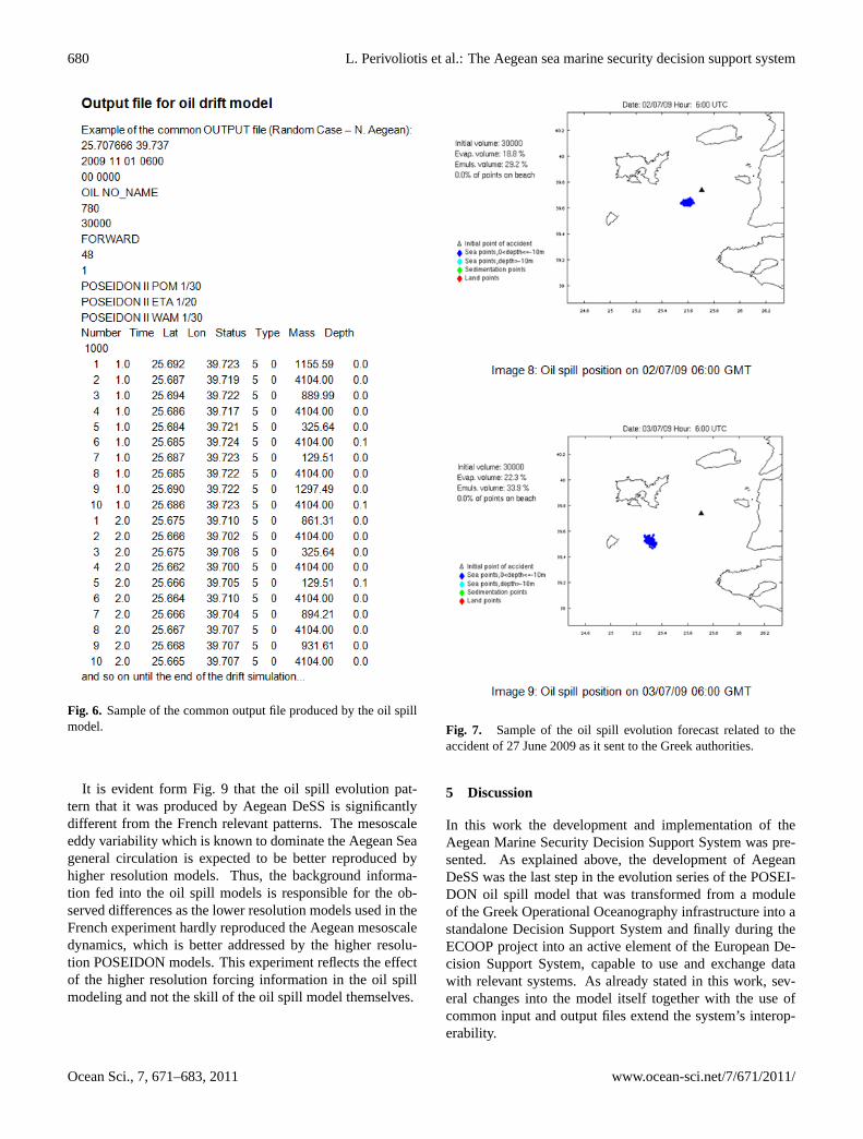
tude and depth inside the water column. Furthermore an ad-ditional status factor is also provided for each particle whichhardy describes its position: 0 (at the bottom), 1 (in the watercolumn), 5 (on sea surface), 10 (beached), 15 (evaporated),20 (gravity centre of the oil slick), 25 (gravity centre of thehead of the oil slick = all particles with size greater than1100 µm and at the sea surface). Any supplementary infor-mation that could be possibly produced by each model suchas the mass or the viscosity of each particle, the percentage ofoil that has been evaporated, emulsified or beached, can bedisplayed in additional columns. A sample of the standardoutput file is given in Fig. 6.
Ocean Sci., 7, 671–683, 2011 www.ocean-sci.net/7/671/2011/

L. Perivoliotis et al.: The Aegean sea marine security decision support system 677
19
Figure 3: The user can setup the desired oil spill simulation scenario either by providing all the
required information manually or by providing the common input file (upper part of the page)
Fig. 3. The user can setup the desired oil spill simulation scenario either by providing all the required information manually or by providingthe common input file (upper part of the page).
4 System operation
During the ECOOP project implementation, the developedAegean Decision Support System was used in operationalmode to support the responsible Greek marine authorities(Ministry of Mercantile Marine, Marine Environment Pol-
lution Division) handling the case of a real accident thattook place in North Aegean area at the end of June 2009.Furthermore, the system was also used to generate simula-tion scenarios for hypothetical accidents in order to exchangedata with Meteo France and test the system’s interoperability.Both cases are presented hereafter.
www.ocean-sci.net/7/671/2011/ Ocean Sci., 7, 671–683, 2011

678 L. Perivoliotis et al.: The Aegean sea marine security decision support system
20
Figure 4: The synthetic results output: the oil spill forecast is presented in graphs vs. time
together with the animation option. Complementary information about the volume of the oil
spill that has been evaporated, emulsificated, reached the beach or the bottom is also provided.
Fig. 4. The synthetic results output: the oil spill forecast is presented in graphs vs. time together with the animation option. Complementaryinformation about the volume of the oil spill that has been evaporated, emulsificated, reached the beach or the bottom is also provided.
4.1 Providing support in a real incident
The accident that alerted the Greek authorities was a collisionbetween two cargo ships in the international waters of theNorth East Aegean Sea occurred during the night of 27 June2009. Although no significant amount of oil was initiallyspilled into the sea, the situation remained critical for sev-eral days as the two ships remained stuck after the collisionand they were towing slowly towards the Turkish coasts. TheGreek authorities requested from the Regional Marine Pollu-tion Emergency Response Centre for the Mediterranean Sea
(REMPEC) to activate the agreement between REMPEC andMOON (Mediterranean Operational Oceanography System)and provide help on preventing and minimizing any possi-ble threat of marine pollution to the Greek territorial watersas well as to the Greek islands, emanating as a result of thecollision incident. HCMR as MOON member responded tothis request by putting the newly developed Aegean Sea De-cision Support System into operational mode. Every day, acomplete report with the evolution of the oil spill for the nexttwo days was provided to the Ministry in order to help in
Ocean Sci., 7, 671–683, 2011 www.ocean-sci.net/7/671/2011/

L. Perivoliotis et al.: The Aegean sea marine security decision support system 679
21
Figure 5: Sample of the common input file used to provide the necessary information to the oil
spill model including explanations for each field.
Fig. 5. Sample of the common input file used to provide the necessary information to the oil spill model including explanations for eachfield.
planning the possible actions in case of major release of oilinto the sea. For the production of the daily forecasting infor-mation, the POSEIDON atmospheric and marine backgrounddata was converted into the common standard NetCDF for-mat and then was fed into the system, as it was required bythe previously described Aegean DeSS specifications. Fi-nally, this alerting situation ended without any further com-plications three days later with the safe towing of the ships tothe Turkish coasts. A sample of the oil spill evolution fore-cast that it was sent to the Greek Ministry is shown on Fig. 7.
4.2 System interoperability
The interoperability between two different systems by usingthe agreed common input and output files has been verifiedbetween HMCR and Meteo France through the exchange ofdata and the comparison of the results. A hypothetical sim-ulation scenario was submitted to the Aegean Oil spill Fore-casting System under the following configuration: The areaof the accident was located between the islands of Evia andAndros in the Aegean Sea, the time of the accident was seton 14 July 2009, the oil had been continuously released into
the sea for the first 24 h while the oil spill fate in the ma-rine environment was followed for five days. The requiredbackground data for the oil spill simulation (oceanic currents,winds and waves) were provided by the high resolution PO-SEIDON models (1/20◦ for the atmospheric forcing, 1/30◦
for the current and wave fields). The original results gener-ated by the system is shown in the Fig. 8.
The same simulation scenario was reproduced by theFrench Oil Spill Forecasting system, as both the input andoutput files of this scenario was sent to Meteo France. TheMOTHY oil spill model was used for the drift simulationwhile the ECMWF winds (1/4◦ horizontal resolution) wereapplied as atmospheric forcing. In the French case, threesimulations were produced as the flow field was provided bythree different sources: (a) climatology, (b) Mercator System(spatial resolution 1/12◦ and (c) Mediterranean ForecastingSystem (MFS, spatial resolution 1/12◦. All the results areplotted together in Fig. 8 with different colors: black forAegean DeSS (Poseidon), red for ECMWF + climatology, or-ange for ECMWF+Mercator and green for ECMWF+MFS(Fig. 9).
www.ocean-sci.net/7/671/2011/ Ocean Sci., 7, 671–683, 2011
680 L. Perivoliotis et al.: The Aegean sea marine security decision support system
22
Figure 6: Sample of the common output file produced by the oil spill model.
Fig. 6. Sample of the common output file produced by the oil spillmodel.
It is evident form Fig. 9 that the oil spill evolution pat-tern that it was produced by Aegean DeSS is significantlydifferent from the French relevant patterns. The mesoscaleeddy variability which is known to dominate the Aegean Seageneral circulation is expected to be better reproduced byhigher resolution models. Thus, the background informa-tion fed into the oil spill models is responsible for the ob-served differences as the lower resolution models used in theFrench experiment hardly reproduced the Aegean mesoscaledynamics, which is better addressed by the higher resolu-tion POSEIDON models. This experiment reflects the effectof the higher resolution forcing information in the oil spillmodeling and not the skill of the oil spill model themselves.
23
Fig. 7. Sample of the oil spill evolution forecast related to theaccident of 27 June 2009 as it sent to the Greek authorities.
5 Discussion
In this work the development and implementation of theAegean Marine Security Decision Support System was pre-sented. As explained above, the development of AegeanDeSS was the last step in the evolution series of the POSEI-DON oil spill model that was transformed from a moduleof the Greek Operational Oceanography infrastructure into astandalone Decision Support System and finally during theECOOP project into an active element of the European De-cision Support System, capable to use and exchange datawith relevant systems. As already stated in this work, sev-eral changes into the model itself together with the use ofcommon input and output files extend the system’s interop-erability.
Ocean Sci., 7, 671–683, 2011 www.ocean-sci.net/7/671/2011/

L. Perivoliotis et al.: The Aegean sea marine security decision support system 681
25
Figure 8: Simulation of oil spill evolution of a hypothetical accident as computed by Aegean DeSS
(event : 14/07/2009 02h10 UTC, 37°N57’‐24°E36’ ; forcing data provide by POSEIDON models
(atmospheric resolution 1/20o, oceanographic and waves 1/30°). Graphics produced by Meteo
France, through the use of the common output file provided by HCMR.
Fig. 8. Simulation of oil spill evolution of a hypothetical accident as computed by Aegean DeSS (event: 14 July 2009 02:10 UTC, 37◦57′ N–24◦36′ E; forcing data provide by POSEIDON models (atmospheric resolution 1/20◦, oceanographic and waves 1/30◦). Graphics producedby Meteo France, through the use of the common output file provided by HCMR.
26
Figure 9: Simulation of oil spill evolution of the same hypothetical accident as in figure 8. The oil
slick drift computed by Aegean DeSS is presented in black (forcing data provide by POSEIDON
models, atmospheric resolution 1/20o, oceanographic and waves 1/30°). The three computed
cases by Meteo France are presented in red, orange and green according to the forcing data:
ECMWF (1/4°)+climatologic currents (in red); ECMWF (1/4°)+Mercator currents (1/12°) (in
orange) ; ECMWF (1/4°)+MFS currents (1/12°) (in green). Graphics produced by Meteo France.
Fig. 9. Simulation of oil spill evolution of the same hypothetical accident as in Fig. 8. The oil slick drift computed by Aegean DeSS ispresented in black (forcing data provide by POSEIDON models, atmospheric resolution 1/20◦, oceanographic and waves 1/30◦). The threecomputed cases by Meteo France are presented in red, orange and green according to the forcing data: ECMWF (1/4◦) + climatologic currents(in red); ECMWF (1/4◦) + Mercator currents (1/12◦) (in orange); ECMWF (1/4◦) + MFS currents (1/12◦) (in green). Graphics produced byMeteo France.
www.ocean-sci.net/7/671/2011/ Ocean Sci., 7, 671–683, 2011

682 L. Perivoliotis et al.: The Aegean sea marine security decision support system
During the project’s lifetime, the Aegean DeSS was usedto provide support to the Greek end user (Ministry of Mer-cantile Marine, Marine Environment Pollution Division) incase of a real accident that took place in North Aegean area.Several reports were produced during the period of crisis anddelivered to the Greek marine authorities providing detailedinformation about the possible areas that could be affected ifthe total amount of the oil spilled into the sea. This frequentreporting provided significant help to the authorities in theprecaution actions that had to be taken in order to minimizethe effects of a possible pollution. This operational use of theAegean DeSS and the interaction with the key users duringa real incident clearly proved that the usage of the productdeveloped within ECOOP enhanced the ability of the endusers to plan the precaution and recovery actions using therisk analysis results that the system is able to provide.
Furthermore, the interconnection between the different oilspill systems that became possible through the use of devel-oped common input and output format provided the opportu-nity of the direct comparison between the results of differentmodelling systems that use different input forcing data. Thiscapability, if further developed, could lead to a network ofoil spill systems capable to use all the available input dataand deliver forecasts in all European seas. Under this con-figuration, the “best choice” solution would be possible to beapplied, i.e. the optimum set of input data would be selectedfor a specific area and fed into the oil spill model that hasbeen proven to better operate in this area.
Acknowledgements.This work was carried out in the framework ofthe ECOOP project, funded by the European Commission’s SixthFramework Program, under the priority Sustainable Development,Global Change and Ecosystems – Contract No. 36355.
The authors would like to thank Denis Paradis from Meteo France,for his kind permission in use of the interoperability experimentdone by Meteo France.
Edited by: P. Oddo
References
Blumberg, A. F. and Mellor, G. L.: A description of a three- dimen-sional coastal ocean circulation model, in: Three-DimensionalCoastal Ocean Circulation Models, Coastal Estuarine Sci.,Vol. 4, AGU, Washington DC, 1–16, 1987.
Delvigne, G. A. L. and Sweeney, C. E.: Natural dispersion of oil,Oil Chem. Pollut., 44, 281–310, 1988.
Gundlach, E. R.: Oil holding capacities and removal coefficientsfor different shoreline types to compute simulate spills in coastalwaters, Proc. Oil Spill Conf., 451–457, 1987.
Janjic, Z. I.: The step-mountain eta coordinate model: further de-velopments of the convection, viscous sublayer and turbulenceclosure schemes, Mon. Weather Rev., 122, 927–945, 1994.
Kallos, G., Nickovic, S., Papadopoulos, A., Jovic, D., Kakaliagou,O., Misirlis, N., Boukas, L., Mimikou, N., Sakellaridis, G., Pa-pageorgiou, J., Anadranistakis, E., and Manousakis,M.: The re-
gional weather forecasting system SKIRON: An overview, Pro-ceedings of the International Symposium on Regional WeatherPrediction on Parallel Computer Environments, 15–17 October1997, Athens, Greece, 109–122, 1997.
Korres, G. and Lascaratos, A.: A one-way nested eddy resolv-ing model of the Aegean and Levantine basins: implemen-tation and climatological runs, Ann. Geophys., 21, 205–220,doi:10.5194/angeo-21-205-2003, 2003.
Korres, G., Lascaratos, A., Hatziapostolou, E., and Katsafados, P.:Towards an ocean forecasting system for the Aegean Sea, GlobalAtmos. Ocean Syst., 8, 191–218, 2002.
Korres, G., Nittis, K., Perivoliotis, L., Tsiaras, K., Papadopoulos,A., Hoteit, I., and Triantafyllou, G.: Forecasting the Aegean Seahydrodynamics within the POSEIDON-II operational system, J.Operat. Oceanogr., 3, 37–49, 2010.
Korres, G., Papadopoulos, A., Katsafados, P., Ballas, D., Perivo-liotis, L., and Nittis, K.: A 2 yr intercomparison of the WAM-Cycle4 and the WAVEWATCH-III wave models implementedwithin the Mediterranean Sea, Mediterr. Marine Sci. J., 12, 129–152, 2011.
Mellor, G.: The three-dimensional current and surface wave equa-tions, J. Phys. Oceanogr., 33, 1978–1989, 2003.
Mellor, G. L. and Yamada, T.: Development of a turbulence clo-sure model for geophysical fluid problems, Rev. Geophys. SpacePhys., 20, 851–875, 1982.
Nittis, K., Perivoliotis, L., Korres, G., Tziavos, C., and Thanos, I.:Operational monitoring and forecasting for marine environmen-tal applications in the Aegean Sea, Environ. Model. Softw., 21,243–257, 2006.
Papadopoulos, A. and Katsafados, P.: Verification of operationalweather forecasts from the POSEIDON system across the East-ern Mediterranean, Nat. Hazards Earth Syst. Sci., 9, 1299–1306,doi:10.5194/nhess-9-1299-2009, 2009.
Papadopoulos, A., Kallos, G., Katsafados, P., and Nickovic, S.: ThePoseidon weather forecasting system: an overview, Glob. Atmos.Ocean Syst., 8, 219–237, 2002.
Paradis D., Negre, J., Madrigal, R., Espino, M., Ferrer, L., Fer-nandes, R., and Perivoliotis, L.: “EuroDeSS Iberian Coast andWestern Mediterranean Sea Marine Security Applications: theV1 system and interoperability tests”, deliverable no D9.2.4.2 ofthe ECOOP project (FP6-2005-Global-4), 2009.
Perivoliotis, L., Nittis, K., and Charissi, A.: An integrated servicefor oil spill detection and forecasting in the marine environment,in: European Operational Oceanography: Present and Future,Publication of the European Communities, Luxembourg, ISBN-92-894-9788-2, 381–387, 2006.
Perivoliotis, L., Nittis, K., and Korres, G.: An operational ser-vice for oil spill detection and forecasting in the Aegean Sea,Abstracts Book of the 5th EuroGOOS Conference, 20–22 May2008, Exeter UK, 87, 2008.
Pham, D., Verron, J., and Roubaud, M.-C.: A singular evolutiveextended Kalman filter for data assimilation in oceanography, J.Marine Syst., 16, 323–340, 1998.
Pollani, A., Triantafyllou, G., Petihakis, G., Nittis, K., Dounas, K.,and Koutitas, C.: The POSEIDON operational tool for the pre-diction of floating pollutant transport, Marine Pollut. Bull., 43,270–278, 2001.834-840
Riemsdijk van Eldik, J., Ogilvie, R. J., and Massie, W. W.: MS4:Marine spill simulation software set, Process descriptions, Dept.
Ocean Sci., 7, 671–683, 2011 www.ocean-sci.net/7/671/2011/

L. Perivoliotis et al.: The Aegean sea marine security decision support system 683
Civil Engineering, Delft Univ. of Technology, Delft, The Nether-lands, 74 pp., 1986.
Smagorinsky, J.: General circulation experiments with the primitiveequations, Mon. Weather Rev., 91, 99–164, 1963.
Stiver, W. and Mackay, D.: Evaporation rate of spills of hydrocar-bons and petroleum mixtures, Environ. Sci. Technol., 18, 834–840, 1984.
Stiver, W., Shiu, W., and Mackay, D.: Evaporation times and ratesof specific hydrocarbons in oil spills, Environ. Sci. Technol., 23,101–105, 1989.
Soukissian, T., Chronis, G., and Poseidon Group (Ballas, D., Vla-hos, D., Nittis, K., Diamanti, Ch., Perivoliotis, L., Papageorgiou,E., Barbetseas, S., and Mallios, A.): Poseidon: a marine environ-mental monitoring, forecasting and information system for theGreek Seas, Mediterr. Marine Sci., 1, 71–78, 2000.
Soukissian, T., Hatzinaki, M., Korres, G., Papadopoulos, A., Kallos,G., and Anadranistakis, E.: Wind and wave atlas of the HellenicSeas, Hellenic Centre for Marine Research Publ., Athens, 300pp., 2007.
Tonani, M., Pinardi, N., Dobricic, S., Pujol, I., and Fratianni, C.:A high-resolution free-surface model of the Mediterranean Sea,Ocean Sci., 4, 1–14,doi:10.5194/os-4-1-2008, 2008.
WAMDIG: The WAM-Development and Implementation Group,Hasselmann, S., Hasselmann, K., Bauer, E., Bertotti, L., Car-done, C. V., Ewing, J. A., Greenwood, J. A., Guillaume, A.,Janssen, P. A. E. M., Komen, G. J., Lionello, P., Reistad, M.,and Zambresky, L.: The WAM Model – a third generation oceanwave prediction model, J. Phys. Oceanogr.,18, 1775–1810, 1988.
www.ocean-sci.net/7/671/2011/ Ocean Sci., 7, 671–683, 2011