the 1925 tri-state tornado damage path and associated storm system
TRANSCRIPT
Johns, R. H., D. W. Burgess, C. A. Doswell III, M. S. Gilmore, J. A. Hart, and S. F. Piltz, 2013: The 1925 Tri-
State tornado damage path and associated storm system. Electronic J. Severe Storms Meteor., 8 (2), 1–33.
1
The 1925 Tri-State Tornado Damage Path and Associated Storm System
ROBERT H. JOHNS,= DONALD W. BURGESS,
= CHARLES A. DOSWELL III,
*
MATTHEW S. GILMORE,+ JOHN A. HART,
# AND STEVEN F. PILTZ
^
=Norman, Oklahoma
*Doswell Scientific Consulting, Norman, Oklahoma
+Department of Atmospheric Sciences, University of North Dakota, Grand Forks, North Dakota
#NOAA/NWS/Storm Prediction Center, Norman, Oklahoma
^NOAA/National Weather Service Forecast Office, Tulsa, Oklahoma
(Submitted 11 May 2012; in final form 04 May 2013)
ABSTRACT
The “Tri-State tornado” event of 18 March 1925, with an official death toll of 695 people, generally is
accepted as the deadliest single tornado in United States recorded history. The officially accepted damage
path is 352 km (219 mi) long. The entire damage path was not surveyed by the Weather Bureau in 1925 to
determine if it truly was continuous, and the nature of the tornado event and the storm that produced it are
not well known. Therefore, as much new data as possible have been gathered about this event in all three
states along and near the purported damage path. Detailed information about the locations where damage
was reported and the type of damage (recorded as “damage points”) was obtained from: interviews and
driving surveys with first- and secondhand eyewitnesses, many local 1925 and later newspapers, local
books, and photographs and other materials found in local libraries and genealogy centers.
After plotting all damage points, a potential damage path of 378 km (235 mi) was indicated. However,
32 gaps ≥1.6 km (1 mi) appeared between consecutive damage points. This paper presents all the damage
points, and indicates which of the gaps might be “real” (i.e., where one tornado ended and another tornado
developed), as well as those gaps more likely to have been a continuous tornado. We speculate that path
segments at the beginning of the potential damage path in eastern Shannon County, MO, and at the end of
the potential path in central Pike County, IN, were both likely from separate tornadoes. In the very rural
and hilly terrain of southeast Missouri, there were areas with a minimum of human development and no
known witnesses to the tornado (parts of Reynolds, Iron and Madison Counties). This led to several
relatively long damage path gaps >3.2 km (2 mi). The existence of the relatively long gaps prevents
confidence in the continuity of the first section of the path. Beginning in central Madison County, MO, and
continuing to Pike County, IN, a distance of 280 km (174 mi), there are no gaps >3.2 km (2 mi), more
strongly suggesting that the tornado was likely continuous for that path segment. Because of having the
highest density of damage reports and the most eyewitness reports, the part of the main damage path that is
243 km (151 mi) long from central Bollinger County, MO to the west edge of Pike County, IN can be
considered likely a continuous path.
The tornado event was associated with what began as a classic supercell in Missouri, transitioning to
high-precipitation mode in Illinois and Indiana. Witnesses saw a wedge tornado along most of the damage
path and a large multivortex tornado in some areas. At two places in Illinois, a satellite tornado may have
appeared at about the same time as the primary tornado was passing nearby. Another previously
unreported tornado with a 32-km (20-mi) damage path occurred in Washington and Jackson Counties, IN,
whose path and trajectory suggests that it may also have been produced by the same supercell. This new
tornado started about 75 min later and about 105 km (65 mi) east-northeast of the apparent end of the Tri-
State tornado damage path in Pike County, IN.
––––––––––––––––––––––––
JOHNS ET AL. 04 May 2013
2
1. Introduction
Henry (1925) concluded that the Tri-State
tornado was singular and continuous, with a path
length of 352 km (219 mi), acknowledged to be
the longest on record (Grazulis 1993). In recent
years, meteorologists have questioned whether
this was really one continuous long-track tornado
or a series of tornadoes associated with the same
convective storm (Doswell and Burgess 1988).
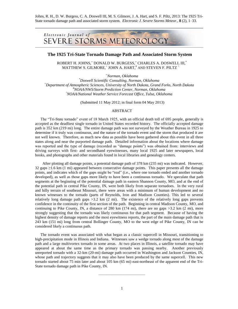
Doswell and Burgess (1988) mentioned that,
in the early 1900s, many tornadoes that were
considered single, very long-track (VLT) tornado
events were actually multiple tornadoes
associated with the same convective storm.
During that time period, a multi-mile gap with
no damage was considered to be “skipping”,
rather than an ending followed by a new tornado.
The term “skipping” meant that the tornado
“lifted” for several or many miles and then the
same tornado caused damage again. While a few
non-damage gaps within a long-track path might
be the result of “skipping”, it is now known that
many of these gaps could be the result of one
tornado ending and another tornado starting with
the same convective storm (Fig. 1). Cyclic
supercells can produce multiple tornadoes with
relatively short gaps between them. This issue is
complicated by the fact that the absence of
damage in a track segment simply might be the
absence of any damage indicator, rather than a
real gap between cyclic supercell tornadoes.
The Weather Bureau Climatological Data
records summarizing the 1925 Tri-State tornado
damage track were gathered for the three
affected states. The Missouri record summary
(Reeder 1925) was not based on a driving
survey, and little was known about what
happened across large segments of the track—
one of which was 64 km (40 mi) long. The
Illinois record summary (Root and Barron 1925)
was based upon a detailed, seven-day automobile
driving survey across Illinois and Indiana, and no
“skipping” was found for 209 km (130 mi) of the
path there (Root 1926). In the Indiana record
summary (Armington 1925), many details were
provided. However, the location of the tornado’s
ending in Indiana is different from what was
mentioned in the Illinois record summary.
__________________________
Corresponding author address: Donald W.
Burgess, National Weather Center, 120 David L.
Boren Blvd., Norman, OK 73072-7323. E-mail:
Figure 1: Two tornadoes from the same
supercell near Zurich, KS on 9 June 2005. The
tornado on the left is shrinking on its way to
dissipation. The tornado on the right is near the
beginning of its track, with a gap <1.6 km (1 mi)
between them. Photograph © 2005 C. Doswell.
Click image to enlarge.
Published Weather Bureau records suggest
that most of the path in Illinois and Indiana may
have been associated with one tornado. However,
the detailed damage survey records that were said
to have been kept at the Illinois State Water
Survey (S. Changnon 2004, personal
communication) could be found neither there or at
the National Climatic Data Center. Thus, it was
impossible for us to give an independent
evaluation of those records in light of modern-day
surveying methods. To investigate possible gaps
along the path, we gathered as much information
as we could along and near the tornado track.
Another question about the Tri-State tornado
concerns the nature of the associated storm
system. Changnon and Semonin (1966)
suggested that the tornado occurred on the front
side of the associated storm, based on hail and
rain occurring after the tornado. However, just
prior to the time of the Changnon and Semonin
paper, it became evident that many tornadoes
occur on the trailing end of supercell storms,
somewhat to the right of the track of the
precipitation core (Browning 1964). Therefore,
we gathered any information we could obtain
about the storm’s nature, precipitation character,
and the relative location and evolution of the
associated tornado (or tornadoes).
Also of interest is the meteorological setting
that would have produced such a long-track and
violent tornado. That subject is not discussed in
this paper, but is described in a companion study
by some of the same authors (Maddox et al.
2013).
JOHNS ET AL. 04 May 2013
3
Field research took 6 y because of the
unfunded nature of the project and the need to
find detailed information in three states and
many counties. Our methods of gathering this
information were inspired by the experience of
one of the authors (DWB), who developed ways
to gather information about the nature of the
1947 Woodward, OK long tornado damage path
(Doswell and Burgess 1988). These methods
and post-processing of the data are mentioned in
section 2, however, more details about these
methods will be given in a forthcoming
publication. The storm-damage path is described
in section 3, and the type of storm and tornado
event are described in section 4. Section 5 is our
concluding discussion.
2. Methods
a. Tornado damage-path analysis
Our basic approach has been to use as many
sources as possible to determine locations where
damage occurred (henceforth “damage points”).
Where damage indicators existed close to the
tornado path and we were aware of locations of
undamaged indicators, we used them as non-
damage points. Gaps between known damage
points along the path are described as “data
gaps”. Non-damage points close to the edge of
the path helped us to determine the maximum
path width, while non-damage points within the
path may represent a real gap where one tornado
dissipated and another formed. Where damage
reports were known to be very close together
(e.g., homes in a city or a farm with home, barn
and outbuildings), a damage point typically
would represent more than one damage item.
For this reason, damage points are typically >30
m (100 ft) apart in areas of dense damage.
Ultimately, damage and non-damage points
were mapped using latitude and longitude values
to assess path continuity and width. We never
can be absolutely certain about the existence of
the tornado within many of the longer gaps,
whereas if we had information about a real gap
where it was known definitely that no damage
occurred, that would be a very different matter.
In any case, it is not possible to be absolutely
sure whether a damage-free gap of even a few
km or less represents the dissipation of one
tornado followed by the development of another.
In a case cited by Doswell and Burgess
(1988), the storm track from a 1984 cyclic
tornadic supercell included gaps of tens of
kilometers between individual tornadoes. With
modern information about tornado events in a
reasonably well-populated area, a gap that large
is most likely strong evidence for the tornado
damage path being discontinuous. For an event
>80 y ago, the existence of large data gaps in the
damage at least would make the issue of tornado
damage-path continuity more questionable.
When this study began, it was not evident what
detailed damage information we would be able to
find.
Damage and non-damage points were
obtained from several sources, including: 1)
local eyewitnesses who were old enough in 1925
to remember many details, and 2) detailed
damage listings from local newspapers of 1925.
Other pertinent sources included: local people
with secondhand knowledge from eyewitnesses
(including family oral history), newspaper and
magazine stories, city address lists, county plat
maps, other types of maps, Red Cross records,
census records, books, and photographs and
movies of damage.
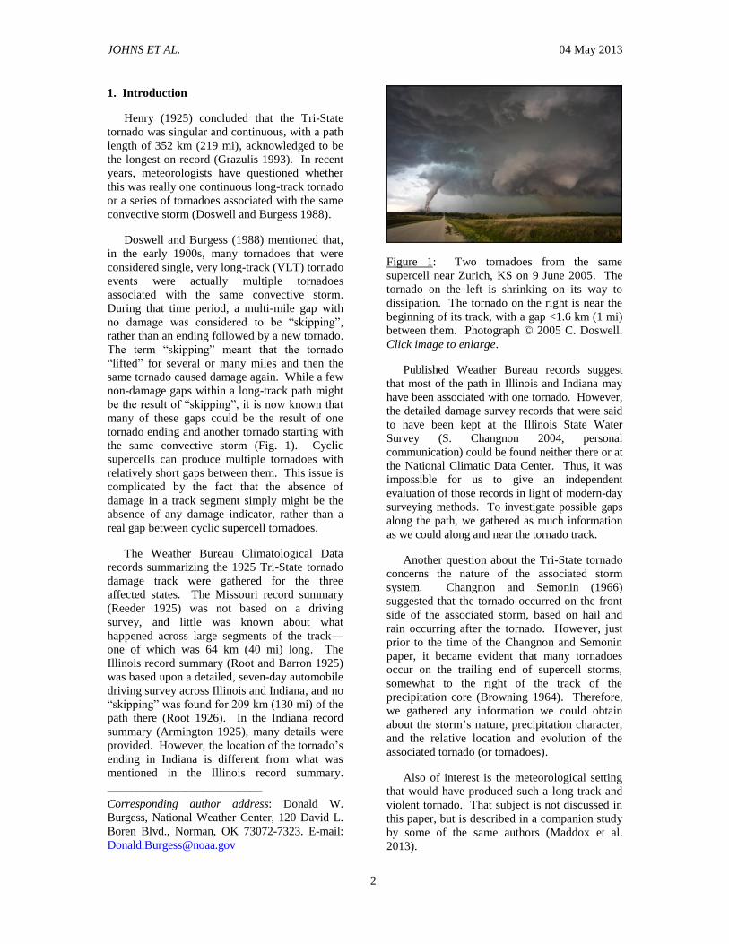
Figure 2: A schematic illustration of the method
used to determine the length of gaps (G) along
the damage path, as described in the text.
When data gathering was completed, the
damage and non-damage points were plotted on
a map. To determine the length of substantial
data gaps, a line was drawn along the center of
the path. Through each damage point, a line was
drawn perpendicular to the center line (Fig. 2).
Once all the damage points were projected onto
the center line, we were able to determine the
location and length of gaps along the center of
path. We defined data gaps along the damage
path that are ≥1.6 km (1 mi) long as “significant
data (SD) gaps”.
JOHNS ET AL. 04 May 2013
4
We used several types of additional
information to see whether SD gaps likely
represent a tornado-dissipation gap or a
continuous tornado path. The types of
information we have used, and their associated
letter codes are listed in Table 1.
Table 1: Letter codes and descriptions for tornado path characteristics in the Tri-State event.
(L) The length of the SD gaps that are ≥1. 6 km (1 mi) long. The likelihood of tornado dissipation increases with greater SD gap length
(D) The directions of the SD gap and the damage paths on both sides. If there are different directions between the center line length of the SD gap and the damage on both sides of the gap, or if there are different directions between the damage paths on each side of an SD gap, it is likely that the SD gap represents tornado dissipation. However, a continuous tornado track is indicated where the damage paths on both sides of the gap lay in the same direction.
(W) The apparent width of the damage path where an SD gap starts and/or ends. In areas of dense damage points, a large width of the damage points at the edge of a short SD gap suggests that the gap represents a continuous tornado path. Also in dense damage areas, if the width of the damage path gets very small near an SD gap, the gap likely represents tornado dissipation. Where a local 1925 newspaper mentions wide tornado damage near or within an SD gap, that gap likely represents a continuous tornado path.
(E) Eyewitness observations in an SD gap. Interviews from firsthand or secondhand eyewitness, or local newspaper stories about eyewitnesses that were near an SD gap, were used to evaluate the likelihood of tornado continuity in the gap. An eyewitness seeing or hearing the tornado as it passed through an SD gap suggests a continuous tornado through the area. An eyewitness seeing either no tornado, a tornado dissipating, or a tornado developing in the SD gap suggests likely tornado absence in the gap.
(N) SD gap information suggested by local 1925 newspapers. Tornado dissipation was likely where one or more local newspapers mention that the tornado ended within an SD gap. Path continuity was more likely within an SD gap if one or more local newspapers mention that certain types of damage occurred in the gap area, but did not specify damage places within the gap.
(P) Non-damage points within an SD gap. Tornado dissipation may have occurred where only one non-damage point has been found in the SD gap, or where several non-damage points appear to be within the path but near its edge. Tornado dissipation is more likely where several verified non-damage points have been found in the center of the gap.
(G) SD gaps near the start or the end of the path. In VLT tornado damage paths (e.g., the 1947 Woodward, OK event), gaps where a tornado dissipates and another develops are most common near the beginning and ending of the long damage path rather than near its middle. SD gaps near the start or end of the damage path therefore may represent tornado dissipation.

JOHNS ET AL. 04 May 2013
5
Figure 3: The length and locations of damage points found along and near Weather Bureau records of the
Tri-State tornado, from Missouri to Indiana. Illustrative times of damage (green labels) in Central Time
(CT = UTC – 6 h) are further discussed in the text. Click image to enlarge. An interactive version of Fig. 3
is available. (All path maps in this paper by J. A. Hart.)
b. Tornado and supercell structure
To learn about the nature of both the Tri-
State tornado and its parent storm, information
was gathered from eyewitnesses and local
newspapers about the following characteristics:
What the storm looked like and how it was
associated with the Tri-State tornado;
Where the Tri-State tornado was located
within the storm and how it evolved;
Characteristics of other associated
tornadoes and severe weather events;
When and where rain and/or hail occurred
relative to the storm and tornado;
The perceptions of weather (temperature,
wind and other storms) that day and how it
changed;
The wind direction and speed close to the
storm;
The location and size of fallen tornado
debris.
Where possible, we also categorized damage
points (e.g., homes, schools, churches, and
business buildings) in one of three intensities: 1)
slightly damaged (e.g., windows blown out,
porch blown down, shingles blown off roof, or
bell tower blown off of church), 2) severely
damaged (e.g., home uninhabitable, or school,
church, or business building unusable), and 3)
destroyed (home or other type of building
completely flattened or blown away). By
mapping the damage-point intensities, we could
learn more about the nature of the parent storm
and the Tri-State tornado [e.g., occurrence of a
satellite tornado or a multivortex structure of the
primary tornado, areas of rear-flank downdraft
(RFD) winds, and in some cases the width of the
Tri-State tornado].
3. Damage-path findings
As of this report, 2395 damage points and
142 non-damage points have been found along
and close to the Tri-State tornado (Fig. 3) from
southeastern Missouri to southwestern Indiana.
[An interactive version of Fig. 3 is available at
http://ejssm.org/ojs/public/vol8-2/map/map.php.]
Using all known damage points, the path length
is estimated to be 378 km (235 mi). Weather
Bureau records from Missouri mention that the
Tri-State tornado began in the center of Reynolds
County, about 6.4 km (4 mi) northwest of
Ellington. However, damage points in Missouri
were found in western Reynolds County and in
eastern Shannon County, west of where the
Weather Bureau recorded the first damage. In
Indiana, Weather Bureau records mention that
the Tri-State tornado ended near Oatsville, next
to the Gibson–Pike County line. However, the
Weather Bureau records from Illinois mention
that the tornado ended 4.8 km (3 mi) southwest
of Petersburg, IN, which is farther into Pike
County. The last damage point we found in that
county was 4 km (2.5 mi) south-southeast of
Petersburg, IN, farther east than the Illinois
records mention. These changes account for the
378-km (235-mi) path length.

JOHNS ET AL. 04 May 2013
6
Figure 4: Damage points (red dots) associated
with a tornado in Washington and Jackson
Counties, IN. Click image to enlarge.
The most common type of damage points in
the path involved homes in rural areas and
towns. Of our 2395 total damage points, 1961
(82%) involved homes. Most of the remainder
involved other types of buildings. On farms, 67
additional damage points involved barns and
outbuildings that were far enough from farm
homes to count as separate damage points.
Another 118 damage points involved business
buildings and some public buildings. Also, 48
damage points involved schools, and 29 more
were churches. Many of the schools were in
rural farm areas, since at that time, one-room
schools were placed about 3.2 km (2 mi) apart
because students generally had to walk to school.
We were able to determine and record the
damage intensities for 2223 homes and
buildings, comprising 92.5% of our total damage
points. The remainder of the damage points
included 84 other objects (e.g., bridges, water
towers, cars, buses, horse wagons, etc.), people
who were injured or killed outside, and 88 areas
of trees. These 172 other damage points are only
7.5% of the total. Although we were able to
assign damage intensities for some of these
“non-building” points, most were unsuitable for
that purpose.
Relatively few estimated damage times were
found along the path, and some of those were
conflicting. Illustrative times have been
annotated on the path in Fig. 3. These are
thought to be the most reliable because they
come from publications of some kind, such as
written records (e.g., those from railroads),
eyewitnesses, or where a number of sources
agreed on the time. However, even with those
criteria, conflicting times were still found. For
example, several sources agreed that the tornado
struck Biehle, MO, at 1400 Central Time (CT1).
However, one eyewitness, who otherwise gave
reliable information corroborated by other
sources, believed that the tornado struck Biehle
at 1410 CT. Because of the relatively few points
and the conflicting times, we discourage use of
the times in Fig. 3 to estimate timing for shorter
path segments. Instead, we suggest using the
average translation speed derived from the
existing times, which was 26 m s–1
(59 mph,
51 kt). First damage in Shannon County, MO
likely began at ≈1240 CT, and last damage in
central Pike County likely ended at ≈1640 CT.
Times for the possibly continuous path segment
from the Shannon–Reynolds County, MO,
border to far western Pike County, IN, would
have been ≈1245 CT to ≈1630 CT.
Weather Bureau records and local 1925
newspapers from Indiana mentioned convective
winds in Jackson County on the same day as the
Tri-State tornado. Given the location and time of
occurrence, they may have been associated with
the same storm. Surprisingly, the newspapers
also mentioned that a 32.2 km (20 mi) long
tornado moved from north-central Washington
County, IN to the Jackson–Jennings County line
(Figs. 4 and 5). Those newspapers revealed
many details about injuries, eyewitness
experiences of the tornado, and the homes and
buildings that were damaged or destroyed.
Using the newspapers, county plat maps and
topographic maps, we determined the location of
this tornado. Since this damage path began
104.6 km (65 mi) from the last Tri-State tornado
damage points in Pike County, IN, and there
were many undamaged items in that gap, we are
confident that if it was associated with the same
storm this would be a real dissipation gap
between two tornadoes. In other words, this
almost certainly was a separate tornado.
Within the 378-km (235-mi) path from
Shannon County, MO to Pike County, IN, there
are 32 SD gaps. A listing of the identification
number, the length, and the location for each of
1 Throughout this article, UTC = CT + 6 h.

JOHNS ET AL. 04 May 2013
7
Figure 5: Tornado damage path (red, at right) in
Washington and Jackson Counties, IN (per Fig.
4), relative to the location of the Tri-State
tornado damage path in eastern Illinois and
southwestern Indiana (at left). Click image to
enlarge.
Figure 6: Histogram by gap-size range, as
labeled, showing the number of ≥1 mi gaps
without damage points from Shannon County,
MO to Pike County, IN. Click image to enlarge.
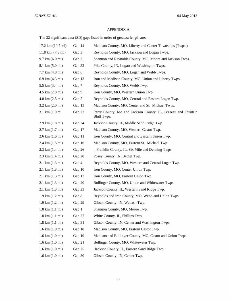
those gaps is in Appendix A. Appendix B
describes each gap area, what types of the Table
1 information were used for the gap, and if the
information resulted in plausible conclusion
about what likely happened within the gap.
Most of the SD gaps are <3.2 km (2 mi) long
(Fig. 6).
More than half (59%) of all SD gaps, and a
large majority (89%) >3.2 km (2 mi) long, are
within the first 109.4 km (68 mi) of the path
from eastern Shannon County to western
Bollinger County, MO (Fig. 7). This part of the
damage path is located within the Mark Twain
National Forest of the Ozark Mountains. Owing
to the rugged topography of this area, there were
few farms, towns, roads, and people in this part
of the damage path when the Tri-State event
occurred, much like it is today. We assumed that
many trees in the area likely would have been
damaged. However, because few people lived in
the area in 1925, there were not very many
sources to learn about what happened to the
trees. We found only 20 damage points
involving trees in this region and learned that
extensive regions west of Bollinger County had
been clear-cut logged at the beginning of the 20th
century. Therefore, in the data-sparse regions
near the beginning of the path in Missouri, the
region looked very different than it does today
(i.e., no extensive forests in 1925). In some of
these cases where eyewitnesses or secondhand
accounts mentioned trees downed by the Tri-State
tornado, we found detailed locations for the
damage points based on uprooted tree mounds and
depressions that still were detectable. Some
independent corroboration was available that these
mounds and depressions could be associated with
the Tri-State tornado, but all of the mounds and
depressions are within the limits of the known
tornado path.
The first SD gap along the damage path,
Gap 1 in Shannon County (Fig. 8), is only
1.8 km (1.1 mi) long, but there was not enough
information to draw conclusions about the nature
of this gap. However, we have been able to
estimate the nature of the second one in this area,
the 9.7 km (6.0 mi) long Gap 2 that goes across
the Shannon–Reynolds County line (Fig. 8). It is
near the beginning of the tornado path, and the
direction of the damage-point path in Shannon
County is different than that in Reynolds County.
It appears that this SD gap is likely a “real” gap
where one tornado dissipated and another
developed. Even though there are quite a few
additional SD gaps (Gaps 3–19) along the path
from Reynolds County to Bollinger County (Fig.
7), there is not enough information to draw
conclusions about their nature. Unlike Gap 2,
the SD gaps and the damage points near the
subsequent gaps appear to be lined up in the
same direction. However, many of the gaps are
>3.2 km (2 mi). The longest is the 17.2 km (10.7
mi) long Gap 14 in the western half of Madison
County, where it crossed the Saint Francois
Mountains (Fig. 9). This part of the Ozark
region is characterized by relatively high, rugged
terrain. Even though this is the longest SD gap
within the entire path, it is much shorter than the
64.4-km (40-mi) gap through the Ozarks noted in
official 1925 Weather Bureau records.

JOHNS ET AL. 04 May 2013
8
Figure 7: Damage points (red is severe damage and complete destruction, green is slight damage), non-
damage points (blue), and gap lengths in the damage path through the Ozark Mountain area from eastern
Shannon County, MO to the western part of Bollinger County, MO. Click image to enlarge.
Figure 8: As in Fig. 7, but zoomed into Shannon and Reynolds County, MO. Click image to enlarge.

JOHNS ET AL. 04 May 2013
9
Figure 9: As in Fig. 7, but zoomed into Iron and Madison County, MO. Click image to enlarge.
Figure 10: As in Fig. 7, but for eastern Madison and Bollinger Counties, MO. Click image to enlarge.
In central and eastern Bollinger County, two
SD gaps (Gaps 20 and 21) are <3.2 km (2.0 mi)
long (Fig. 10). These are in hills with fewer
farms and buildings than in nearby agricultural
areas. The tornado track likely is continuous
through both of these Bollinger County gaps,
since the width of the damage points on both
sides of each gap is 0.8–1.2 km (0.5–0.75 mi)
wide. Furthermore, the directions of the SD gap
and the damage-path points on both sides are the
same.
Across most of Perry County, there are no SD
gaps between damage points (Fig. 11). However,
near the eastern border of Perry County, the
3.1-km (1.9-mi) long Gap 22 crossed the
Mississippi River into Jackson County, IL. In this
area, the river is oriented more east–west than
north–south, so most of the SD gap is over the
river. The lack of damage points there is mostly
because of a lack of structures on or close to the
river. This gap also is likely a continuous
tornado track since the width of the damage
points on both sides of the SD gap is >0.8 km
(0.5 mi) wide, and since the directions of the gap
and the adjacent damage path points are the
same. Furthermore, an eyewitness on the Illinois
side of the river saw the tornado crossing the
river, appearing as a large dark mass that was
throwing river water.

JOHNS ET AL. 04 May 2013
10
Figure 11: As in Fig. 7, but for Perry County, MO and the western edge of Jackson County, IL. Click
image to enlarge.
Figure 12: As in Fig. 7, but for Jackson and western Williamson Counties, IL. Click image to enlarge.
In the western half of Jackson County, IL,
three SD gaps are <3.2 km (2.0 mi) long
(Fig. 12). The first two [2.1 km (1.3 mi) long
Gap 23 and 2.9 km (1.8 mi) long Gap 24] are
along the Mississippi River floodplain,
characterized then and now mostly by open
agricultural land with few buildings. The third
SD gap [1.6 km (1.0 mi) long Gap 25] is in the
hilly area east of the floodplain where there also
may have been few farm homes and other
buildings.
Through all three of these SD gaps, the
tornado damage path was likely continuous for
several reasons. The gaps and nearby damage
points appear to be lined up in the same
direction. Gaps 23 and 24 are close together in
the floodplain area. On the west edge of Gap 23
is Gorham, IL, where many people were killed
and the damage points indicate a path about
1.2 km (0.75 mi) wide. Just one damage point
was found in the floodplain on the east edge of
Gap 23 and the west edge of Gap 24. However,
this damage point represents a farm home and
farm buildings that were flattened, killing some
of the family members. On the east edge of Gap
24 where the floodplain ends and the damage
points of homes, buildings and trees are at least
0.8 km (0.5 mi) wide, one person was killed. A
person who lived in the area mentioned that the
tornado was seen by his parents in Gaps 23 and
24. Farther east into the hilly area, the damage
points on both sides of Gap 25, which is only
1.6 km (1.0 mi) long, are about 1.2–1.6 km (0.75–
1 mi) wide. The local newspaper mentions that as
the tornado moved from Gorham to
JOHNS ET AL. 04 May 2013
11
Murphysboro where these three gaps are located,
the damage path appeared to be from 0.2–1.6 km
(200 yd to 1 mi) wide through the entire area.
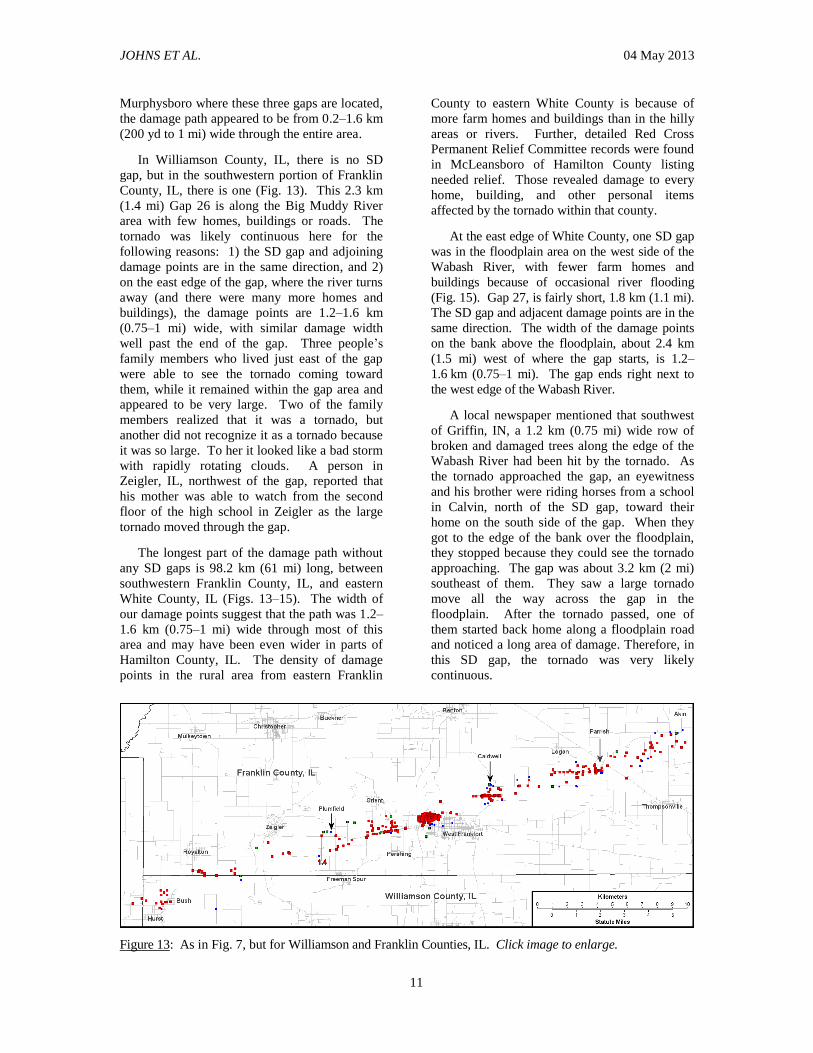
In Williamson County, IL, there is no SD
gap, but in the southwestern portion of Franklin
County, IL, there is one (Fig. 13). This 2.3 km
(1.4 mi) Gap 26 is along the Big Muddy River
area with few homes, buildings or roads. The
tornado was likely continuous here for the
following reasons: 1) the SD gap and adjoining
damage points are in the same direction, and 2)
on the east edge of the gap, where the river turns
away (and there were many more homes and
buildings), the damage points are 1.2–1.6 km
(0.75–1 mi) wide, with similar damage width
well past the end of the gap. Three people’s
family members who lived just east of the gap
were able to see the tornado coming toward
them, while it remained within the gap area and
appeared to be very large. Two of the family
members realized that it was a tornado, but
another did not recognize it as a tornado because
it was so large. To her it looked like a bad storm
with rapidly rotating clouds. A person in
Zeigler, IL, northwest of the gap, reported that
his mother was able to watch from the second
floor of the high school in Zeigler as the large
tornado moved through the gap.
The longest part of the damage path without
any SD gaps is 98.2 km (61 mi) long, between
southwestern Franklin County, IL, and eastern
White County, IL (Figs. 13–15). The width of
our damage points suggest that the path was 1.2–
1.6 km (0.75–1 mi) wide through most of this
area and may have been even wider in parts of
Hamilton County, IL. The density of damage
points in the rural area from eastern Franklin
County to eastern White County is because of
more farm homes and buildings than in the hilly
areas or rivers. Further, detailed Red Cross
Permanent Relief Committee records were found
in McLeansboro of Hamilton County listing
needed relief. Those revealed damage to every
home, building, and other personal items
affected by the tornado within that county.
At the east edge of White County, one SD gap
was in the floodplain area on the west side of the
Wabash River, with fewer farm homes and
buildings because of occasional river flooding
(Fig. 15). Gap 27, is fairly short, 1.8 km (1.1 mi).
The SD gap and adjacent damage points are in the
same direction. The width of the damage points
on the bank above the floodplain, about 2.4 km
(1.5 mi) west of where the gap starts, is 1.2–
1.6 km (0.75–1 mi). The gap ends right next to
the west edge of the Wabash River.
A local newspaper mentioned that southwest
of Griffin, IN, a 1.2 km (0.75 mi) wide row of
broken and damaged trees along the edge of the
Wabash River had been hit by the tornado. As
the tornado approached the gap, an eyewitness
and his brother were riding horses from a school
in Calvin, north of the SD gap, toward their
home on the south side of the gap. When they
got to the edge of the bank over the floodplain,
they stopped because they could see the tornado
approaching. The gap was about 3.2 km (2 mi)
southeast of them. They saw a large tornado
move all the way across the gap in the
floodplain. After the tornado passed, one of
them started back home along a floodplain road
and noticed a long area of damage. Therefore, in
this SD gap, the tornado was very likely
continuous.
Figure 13: As in Fig. 7, but for Williamson and Franklin Counties, IL. Click image to enlarge.

JOHNS ET AL. 04 May 2013
12
Figure 14: As in Fig. 7, but for Hamilton County, IL. Click image to enlarge.
Figure 15: As in Fig. 7, but for White County, IL and western Posey County, IN. Click image to enlarge.
Figure 16: As in Fig. 7, but for Posey County, IN and western and central Gibson County, IN. Click image
to enlarge.

JOHNS ET AL. 04 May 2013
13
Beyond the Wabash River in Indiana, the
next two SD gaps were located in the Black
River floodplain area, a few kilometers northeast
of Griffin, IN (Fig. 16). The 2.3-km (1.4-mi)
Gap 28 is in northwest Posey County near the
Posey/Gibson County line. Gap 29 in Gibson
County is only 1.9 km (1.2 mi). Some
interviewees mentioned that almost no one lived
in this part of the floodplain area in 1925, and the
same still was true during our survey. The two
SD gaps and the damage points we found near
them appear to be lined up in the same direction.
Local people apparently were observing a
multivortex tornado as it destroyed most of the
homes and buildings in the town of Griffin,
<4.8 km (3 mi) from the start of Gap 28. An
eyewitness who lived on a ridge about 0.4 km
(0.25 mi) northwest of Griffin saw one part of
the tornado coming back through town as it was
moving out of Griffin. Also, a local newspaper
mentioned that clouds in several directions
moved around and came together (a common
description of a multivortex tornado by
eyewitnesses, even today) causing destruction in
Griffin. The newspaper also reported that two
men who were close to Foote Pond, about 1.6–
2.4 km (1–1.5 mi) north of Gap 28, saw the
tornado moving away from Griffin and going
across Gap 28 south of their location. The two
men saw two tornadoes meet and form one giant
tornado within the gap. This could mean either
that the Tri-State tornado was continuing to be a
multivortex system, or that one tornado
dissipated as it moved around a new tornado that
had already developed and was growing in size,
similar to what happened northeast of Hesston,
KS on 13 March 1990 (Davies et al. 1994).
However, since the two men could have watched
a multivortex tornado instead of seeing one
tornado dissipate and another tornado develop,
we do not have enough information to make a
firm determination about the nature of Gap 28.
A tornado likely moved continuously across Gap
29. Because the two men who were close to
Foote Pond saw a tornado become large as it was
leaving Gap 28 (close to entering Gap 29), and
the width of the damage located <1 mi from the
end of the short Gap 29 was about 1.2–1.6 km
(0.75–1 mi) wide, it seems likely that the tornado
was continuous across Gap 29.
The next two SD gaps were in eastern Gibson
County, IN (Fig. 17) along a frequently flooded
area of the Patoka River. There were no homes
or buildings in the area during our survey, and
likely none in 1925 either. Gap 30 was 1.6 km
(1.0 mi) across the Patoka River while Gap 31
was 1.8 km (1.1 mi) on the east side of Patoka
River. These two gaps are near the end of the
damage path where it was more likely for a
tornado to dissipate and another to form.
However, for several other reasons, we propose
that the tornado was likely continuous as it
crossed these gaps. From the locations of our
damage points, the direction of the damage path
appears to shift to the right across central and
eastern Gibson County. However, in the area
where the two gaps are located, there are no
noticeable direction shifts.
A local newspaper reported a narrowing
damage path after the tornado crossed Princeton,
IN. Our damage points suggest that in Princeton,
the damage path was about 1.2 km (0.75 mi)
wide (Fig. 18) while the local newspaper
mentioned that the tornado was 0.8 km (0.5 mi)
wide as it crossed the road that goes north from
Francisco. This road and the 0.8-km (0.5-mi)
wide damage path are on the west edge of Gap
30. The damage points near the east end of Gap
31 suggest that the damage path was between
0.4–0.8 km (0.25–0.5 mi) wide, certainly not
very small. Given that the path on both sides of
the floodplains appears to be fairly wide, it
seems unlikely that a tornado had dissipated and
another developed within either gap. An
interviewee said that at his family’s farm, the
fences were blown away, and cattle appeared to
have been lost initially. However, several days
later, they found their livestock in the damage
area south of Oatsville, about 7.2–8.0 km (4.5–
5 mi) from their farm and just past the east edge of
Gap 31. The eyewitness said the cows were
located there since the tornado had torn down all
the farm fences and other barriers along that 7.2–
8.0-km (4.5–5-mi) path. Therefore, it appears that
the tornado passed continuously through the gaps.
The last SD gap was in western Pike County,
IN, an agricultural and mining area where many
roads, homes, and buildings exist, as in 1925.
Gap 32 is 8.1 km (5.0 mi), much longer than any
of the other gaps in Illinois and Indiana. The gap
starts fairly close to Oatsville, IN, where several
local newspapers said that the Tri-State tornado
ended. Also, Weather Bureau records from
Indiana mentioned that the Tri-State tornado
ended at Oatsville, close to where this gap starts.
In 1925, an interviewee lived in a home located
on an east–west road about 1.6 km (1 mi) east of
Oatsville, inside the gap and near where the gap

JOHNS ET AL. 04 May 2013
14
started. Her family’s home was not hit by the
tornado. She also pointed out other undamaged
homes along the east–west road, most of which
were within the gap area. A different eyewitness
was in his home with his ill father, about
11.3 km (7 mi) east of where Gap 32 starts and
about 5.6–6.4 km (3.5–4 mi) southeast of where
Gap 32 ends. During that afternoon, he looked
out of the kitchen door on the west side of his
home, noticing dark clouds moving up from the
southwest. As the dark clouds moved west-
northwest of him, he noticed what he thought
was an “arm coming down out of the clouds”.
When he told his father what had seen, his father
went to the kitchen door, and they both looked
out at the dark clouds. He noticed that the “arm”
had reached the ground; his father told him it
was a tornado. Since the feature did not seem to
be coming toward them, they watched as it
Figure 17: As in Fig. 7, but for eastern Gibson and Pike Counties, IN. Click image to enlarge.
Figure 18: As in Fig. 7, but zoomed in on Princeton, IN. Click image to enlarge.
JOHNS ET AL. 04 May 2013
15
Figure 19: As in Fig. 7, but zoomed in on Murphysboro, IL. Click image to enlarge.
Figure 20: As in Fig. 7, but zoomed in on West Frankfort, IL. Click image to enlarge.
moved to their north until it disappeared. This
suggests a new tornado before the end of Gap 32.
They also noticed when this new tornado ended
south-southeast of Petersburg. Based on this
information, local newspapers, and one of the
Weather Bureau records, we determined that this
was likely a “real” gap where one tornado
dissipated and another formed. However, since
the new tornado was observed before the end of
Gap 32, this “real” gap appears to have been
<8.0 km (5 mi).
4. Storm-scale results
From our sources mentioned in section 2, we
obtained information about the nature of both the
Tri-State storm and associated tornadoes. (In
supplemental Appendix C, the details about
these findings are described for each of the 14
counties along the damage path from Missouri to
Indiana.) Our findings show that a supercell
produced the Tri-State tornado, which occurred
on the right side and near the back end of the
storm, rather than the front end.
JOHNS ET AL. 04 May 2013
16
Eyewitnesses in or near the tornado damage
path in Shannon County, MO, Bollinger County,
MO, Perry County, MO, Jackson County, IL,
White County, IL, and Posey County, IN,
noticed that the main part of the storm with all or
part of the precipitation core had passed to the
north of them, followed by the tornado
approaching them from the west-southwest.
Such descriptions are consistent with modern
conceptual models of tornadic supercells (e.g.,
Browning 1964; Lemon and Doswell 1979).
In several counties, heavy rain and very large
hail occurred with what was likely a part of the
precipitation core a few miles north of the
tornado path. In Jackson County, IL, the storm
produced baseball size (7 cm; 2.75 in) hail about
5.6 km (3.5 mi) north of the damage path in
Murphysboro, with much smaller hail in
Murphysboro. In Hamilton County, IL, the
storm produced 3.5-inch-diameter hail a few
miles north of the damage path (at
McLeansboro) that was larger than any hail
along the damage path. This is common with
supercells (Browning 1965; Lemon et al. 1977).
In many of the counties along the damage
path, pieces of moderately large debris (e.g.,
clothes, rugs, tin roofing, boards, etc.) generated
by the tornado landed in areas from 1–36 km
(0.5–22 mi) north-northwest of the path. Also,
some of the small debris with people’s names
listed on them (e.g., letters, checks, photographs,
etc.) typically were blown to the northeast. The
farthest traveled 653 km (406 mi) east-
northeastward from Murphysboro, IL to near
Newark, OH. Final resting locations of
“intermediate” and “small” debris relative to the
location of the storm and the damage path in the
Tri-State tornado are similar to relative locations
found in other strong and violent supercell
tornadoes (Snow et al. 1995).
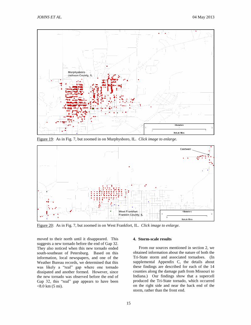
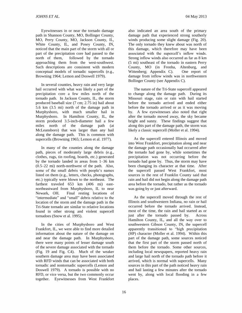
In the cities of Murphysboro and West
Frankfort, IL, we were able to find more detailed
information about the nature of the damage on
and near the damage path. In Murphysboro,
there were many points of lesser damage south
of the severe damage associated with the tornado
(Fig. 19 and Fig. C4). Much of the weaker
southern damage area may have been associated
with RFD winds that can be associated with both
tornadic and nontornadic supercells (Lemon and
Doswell 1979). A tornado is possible with no
RFD, or vice versa, but the two commonly occur
together. Eyewitnesses from West Frankfort
also indicated an area south of the primary
damage path that experienced strong southerly
winds producing some slight damage (Fig. 20).
The only tornado they knew about was north of
this damage, which therefore may have been
associated with the supercell’s inflow winds.
Strong inflow winds also occurred as far as 8 km
(5 mi) southeast of the tornado in eastern Perry
County, MO (in Fronha, Altenburg, and
Wittenberg; Appendix C). One report of
damage from inflow winds was in northwestern
Bollinger County (see Appendix C).
The nature of the Tri-State supercell appeared
to change along the damage path. During its
Missouri stage, rain or rain with hail started
before the tornado arrived and ended either
before the tornado arrived or as it was moving
by. A few eyewitnesses also noted that right
after the tornado moved away, the sky became
bright and sunny. These findings suggest that
along this part of the damage path, the storm was
likely a classic supercell (Moller et al. 1994).
As the supercell entered Illinois and moved
into West Frankfort, precipitation along and near
the damage path occasionally had occurred after
the tornado had gone by, while sometimes the
precipitation was not occurring before the
tornado had gone by. Thus, the storm may have
been changing its character at that time. After
the supercell passed West Frankfort, most
sources in the rest of Franklin County said that
rain and hail did not begin along the damage path
area before the tornado, but rather as the tornado
was going by or just afterward.
As the supercell moved through the rest of
Illinois and southwestern Indiana, no rain or hail
occurred before the tornado arrived. Instead,
most of the time, the rain and hail started as or
just after the tornado passed by. Across
Hamilton County, IL, and all the way over to
southwestern Gibson County, IN, the supercell
apparently transitioned to “high precipitation
(HP) character (Moller et al. 1994). Within this
part of the damage path, some sources noticed
that the first part of the storm passed north of
them before the tornado. Some other sources,
including local newspapers, reported heavy rain
and large hail north of the tornado path before it
arrived, which is normal with supercells. Many
sources in this part of the path noticed heavy rain
and hail lasting a few minutes after the tornado
went by, along with local flooding in a few
places.
JOHNS ET AL. 04 May 2013
17
Several sources reported rain and hail for a
few miles south of some part of damage path as
the storm was going by. However, several
sources also stated that after the rain and hail
finally ended along the damage path, it cleared
up and became sunny, which is common with
supercells. During the remainder of the damage
path from southwestern Gibson County to Pike
County, IN, most of the rain and hail followed
the tornado, did not last as long, and occurred
without flooding. So, in this part of the damage
path, the storm may have changed back to being
a classic supercell.
In summary, it appears that the Tri-State
storm started as a classic supercell in Missouri,
may have changed to an HP supercell in the
central part of southern Illinois, and stayed that
way until entering Indiana. Moller et al. (1994)
suggested that HP supercells do not produce
strong and violent tornadoes as often as classic
supercells; however, a major tornado associated
with an HP supercell may be more likely east of
the Great Plains. The Tri-State supercell may
have been in an HP mode over some part of its
very long damage path.
When the first tornado started with the Tri-
State supercell in Shannon County, MO, it was
observed to be funnel-shaped and was not large.
However, when the primary tornado crossed
Reynolds County, it was already large. As it was
crossing Iron County, the tornado had become
large enough to not appear funnel-shaped. By
the time the Tri-State supercell was entering
Bollinger County, the primary tornado was
already wedge-shaped; to many people it
appeared as a big black cloud rolling along the
ground. From west of Bollinger County, MO, to
Gibson County, IN, the primary tornado was
very large, sometimes with multivortex
appearance. Since it was so large, many people
observed a big black storm “cloud”, “smoke”,
“fog”, or “big black mass” that was “rolling” or
“swirling” around on the ground as it
approached. As a result, some people did not
recognize it as a tornado. Occasionally, it was
observed as a multivortex tornado. In several
places from Franklin County, IL, to where the
tornado damage ended in Pike County, IN, some
eyewitnesses saw a funnel-shaped tornado that
was a part of the multivortex circulation.
The Tri-State supercell could have developed
satellite tornadoes at two places where homes
were destroyed: eastern Franklin and
southwestern Hamilton Counties, IL. They were
about 0.8–1.2 km (0.5–0.75 mi) south of the
primary damage path. Also, between the damage
point in eastern Franklin County and the primary
path to the north, some buildings were not
damaged.
Along most of the damage path, the Tri-State
supercell developed a primary tornado that was
very large and wedge-shaped, occasionally
displaying multiple vortices in Illinois and
Indiana. Also, the Tri-State supercell apparently
developed two brief satellite tornadoes just south
of the primary tornado in central Illinois. The
nature of the report of alleged twin tornadoes on
parallel tracks near Biehle, MO (in the original
Weather Bureau report of the event and
mentioned by Changnon and Semonin 1966), is
unknown. We found no evidence to corroborate
that report; however, it might have been another
instance of a satellite tornado, evidence of a
multivortex mode at that time, or perhaps
apocryphal.
5. Summary and discussion
As we expected, our findings have shown
that the 1925 Tri-State tornado event was
associated with a supercell storm. We found that
the storm was in the form of a classic supercell
as it moved from where the tornado damage
started in southern Missouri and reached the
Mississippi River. However, as the supercell
traversed southern Illinois, it may have become
an HP supercell near West Frankfort and stayed
that way until it got to southwestern Indiana.
We were able to find many places where
tornado damage occurred along the supercell’s
path from Shannon County, MO, to Pike County,
IN, which is 378 km (235 mi) long. We also
found more than one tornado likely associated
with the supercell along this path. We found two
places in Illinois where brief satellite tornadoes
apparently occurred. A primary tornado was
associated with the supercell in every county
from Missouri to Indiana. There were two
separate tornadoes near both ends of the damage
path. In the intervening part of the damage path,
we cannot determine conclusively if there were
any real gaps where one tornado ended and
another started. In the 280-km (174-mi) part of
this path from central Madison County, MO, to
the west edge of Pike County, IN, no gaps
exceeded 3.2 km (2 mi), suggesting a continuous
tornado for that path segment. More damage
JOHNS ET AL. 04 May 2013
18
reports and eyewitness interviews suggest a
likely continuous path segment from north-
central Bollinger County, MO, to the west edge
of Pike County, IN—a distance of 243 km (151
mi). In the Griffin area, and also in many other
places in Illinois and Indiana, the primary
tornado was a multivortex (Agee et al. 1976).
Unfortunately, since the Tri-State tornado
event occurred >80 y ago, and it was sometimes
in a multivortex form, our findings cannot
determine whether there was just one continuous
primary tornado or how many separate tornadoes
occurred in association with the long-lived
supercell. With no radar information available,
we cannot know for sure if the supercell changed
from classic to HP structure along the damage
path. However, we can compare what we have
found about the Tri-State event with more recent
major tornado events where a supercell produced
a long damage path from its tornadoes.
On 28 March 1984, a long-lived supercell
produced a series of devastating tornadoes along
a 708-km (440-mi) path from Georgia to South
Carolina and North Carolina. This storm
developed near a major mesoscale cyclone that
had formed near the original synoptic-scale
cyclone (Doswell and Burgess 1988). The
supercell moved along with the intensifying
mesoscale cyclone while tornadic. Since this
event formed similarly to the 1925 Tri-State
supercell event, we can compare their tornado
paths.
The part of the 28 March 1984 supercell path
from northeastern South Carolina to east-central
North Carolina was about 217 km (135 mi) long
and had gaps between its serial tornadoes of <16
km (10 mi). The longest continuous tornado
damage path within this area appeared to be only
about 68 km (42 mi) long. In several of the
gaps, a new tornado formed several miles to the
right (rather than directly ahead) of where the
previous tornado ended. This is very different
from the Tri-State gaps. In the latter, the only
area where there was an SD gap in a different
direction than the damage path was close to the
beginning in Missouri. In a cyclic supercell,
tornado tracks on either side of gaps are typically
in different directions than the track of the
supercell itself (Fujita 1974). The 28 March
1984 supercell had such path characteristics,
with a series of distinctly separate tornadoes.
Since the 1925 Tri-State supercell only had one
gap in a different direction than the damage path,
long-track tornado continuity is more likely than
in the 28 March 1984 event.
On 9 April 1947, a major tornado event
occurred from the Texas Panhandle through
northwestern Oklahoma and southern Kansas
striking Woodward, OK. This initially was
listed as one continuous VLT tornado 356 km
(221 mi) long. However, Doswell and Burgess
(1988) concluded that it involved a series of four
tornadoes toward the end of the damage path.
The gaps between these four tornadoes were 6.5–
9.7 km (4–6 mi), In three of these gaps, one
tornado ended and a new one formed several
miles to the right of the previous tornado’s track.
Therefore, it is likely that the Woodward
supercell was cyclic, and the tornado track was
not continuous over the entire length. However,
unlike the 28 March 1984 event, no gaps in the
center segment of the damage path could be
found, and a continuous VLT tornado caused
very severe damage for at least 161 km (100 mi).
Over a substantial part of the Woodward
tornado’s path, especially in the Texas
Panhandle, there were few structures and little
evidence of damage.
The Tri-State event may be more similar to
the 09 April 1947 event than to the 28 March
1984 event. For the Tri-State event, we found
substantial gaps near both ends of damage path
likely representing tornado dissipation and new
development. However, away from the path’s
beginning and end, we did not find any
significant gaps that were in a different direction
than the damage path. As such, the Tri-State
supercell was very close to steady-state along
most of the path, apart from the early and
dissipating stages of the tornadic phase.
On 3 April 1974, a major tornado outbreak
occurred in many states east of the Great Plains.
One of the supercells created a series of
tornadoes along a 420-km (261-mi) path from
central Illinois to southeastern lower Michigan.
Near the middle was a continuous, 194-km (121-
mi) tornado damage path from west of Lafayette,
IN, to east of Goshen, IN, within which 24
people were killed and 432 were injured. Radar
imagery suggested an HP supercell in the form
of a line-echo wave pattern along this continuous
damage path (Agee et al. 1976). After the 1925
Tri-State supercell moved past West Frankfort,
IL, it may have resembled this 1974 supercell.
JOHNS ET AL. 04 May 2013
19
Even though we are unable to say
conclusively if there were real gaps along the
center part of the 1925 Tri-State damage path,
two were apparent near both ends. Omitting the
beginning and ending path segments, the Tri-
State tornado started either in far western
Reynolds County or in extreme southeastern
Shannon County, MO, and ended in western
Pike County, IN, having a possible path length of
at least 352 km (219 mi). Despite this length
estimate being the same as originally reported,
the revised path differs from that original
version, notably at the beginning and the end.
The part of the Tri-State damage path that is
280 km (174 mi) long from central Madison
County, MO to the west edge of Pike County, IN
was found not to have any gaps along the
damage path ≥3.2 km (2 mi) long, and there are
no significant damage-point tracks in a different
direction than the main path. Because of the
relative density of damage and eyewitness
reports, the 243-km (151-mi) part of the main
damage path from central Bollinger County, MO
to the west edge of Pike County, IN can be
considered the most likely to be continuous.
Still, it is not possible to rule out completely
the possibility of “handoffs” within our data
gaps. In many cases, for the SD gaps <3.2 km (2
mi) long, we know that if the gap was real, the
distance between the two tornadoes would be
shorter than the gap we found. This is because
eyewitnesses saw the tornado within the gap
and/or on one or both sides of the gap. The
damage path was 0.8–1.6 km (0.5–1 mi) wide at
the edge of the gap. Also, Weather Bureau
meteorologist Clarence Root drove on a path
survey from western Jackson County, IL to Pike
County, IN, finding absolutely no “skipping” for
209 km (130 mi). Therefore, although we can’t
say definitively if it contained just one tornado,
we do know that this part of the damage path
was nearly continuous.
ACKNOWLEDGMENTS
We really appreciate being able to find so
many people who were in or had been in or near
the counties where the tornado occurred and
were willing to give us information about what
happened.
Some of those people we met with in the
damaged counties or nearby were very helpful by
providing us old newspapers, photographs, maps,
and/or other information, and/or showing us
where we should go to find out what happened,
and/or also giving us the names and addresses of
eyewitnesses we should contact to learn what
they experienced and where damage occurred.
They and the counties we gathered information
about from them are:
Missouri: Shannon County: Helen (Ferguson)
Thompson. Bollinger County: Bob Fulton,
Connie (Murray) Caster and Anna (Shrum)
Mungle. Perry County: Lonnie Schott, Mary
Jane Buchheit and Carla Jordan.
Illinois: Jackson County: C. J. Calandro, Mary
Riseling, Cliff Swafford, Ken Cochran, and Mike
Jones. Franklin County: Lynda Savka, Dawn
Taitt, Goebel and Allen Patton, Pat Hindman,
Ryan Presley, Dave Sanders, Shirley Payne,
Barbara Cairel, Lois Short, Mary Taylor, Mary
Eubanks, Kyran Hanagan, David Garavalia, and
Dayle Williams. Hamilton County: Eileen
Drake, Micki Lazzuri, Nadine (Braden) Broyles,
and Kenneth and Joyce Kirkpatrick. White
County: Barry Cleveland, Charlene Shields,
Janet Armstrong, Larry Gwaltney, Jan Prince,
Linda Kuykendall.
Indiana: Posey County: Beverly Stone, Pat
Hancock, and Sue Travis. Gibson County: Rev.
William Ping, Peggy Callis, Bonnie Johnson,
Dean Higginbotham, and Jean Watkins. Pike
County: Robert Jack Kinman and Shirley
Behme.
Those who went on driving surveys with us,
and showed us where damage occurred or places
that were not damaged, are:
Missouri: Bollinger County: Bob Fulton.
Bollinger and Perry Counties: Lonnie Bangert.
Perry County: Lonnie Schott, Bob Fielher, and
Dale and Arlene (Petzoldt) Koenig.
Illinois: Jackson County: Denver Brewer,
Brian Brewer, C. L. Calandro, Laura Varner,
and Ella Cook. Williamson County: James
Holland. Franklin County: Charles Brandon,
Don Vancil, Charles Mathis, Bob Proctor, Reba
(Sanders) Bennett, Pete Jackanicz, Marge
(Murphy) Presley, Edward Vene, Burl Worsham,
Stanley Diadus, Gary and Mary Ann (Thomas)
Wade, James Carrier, Cordell Cairel, Eula
(Kerley) Spain, Lovill (Woodrum) Carlile, Jerry
Duckworth, Ronald Huffine, Dempsey Summers,
and William Neal. Hamilton County: Nadine
(Braden) Broyles, Howard Taylor, Mark White,

JOHNS ET AL. 04 May 2013
20
Cecil Shasteen, Micki Faruzzi, Roy Schuster,
Eddie Thompson, and Eli Hook. Hamilton and
White Counties: Lee Wilson. White County:
Dorothy Jordan, Roy Robley, Frank Nix, Bob
Armstrong, Hal Davenport, Ella Mae (Walker)
Brown, and Cyril Barton.
Indiana: Posey County: Bob Nesler, Ed and
Beverly Stone, and Ed Martin. Posey and
Gibson Counties: Wayne Couch and Wayne
Sharp. Gibson County: David and Kathryn
Armstrong, Alice (Bush) Strickland, Cody White,
Jack Woods, Jim Kolb, Virginia (Durring) Ott,
and Phil Perry. In Pike County: Delmas Wyatt.
Those who had written an account, a story or
a book about how they or others experienced this
event, and about where damage occurred, are:
Missouri: Reynolds, Iron, Madison, Bollinger,
and Perry Counties: Matt Chaney (Chaney,
1997). Matt was kind enough to let us use all his
interview notes and other background material.
Bollinger County: Dorothy (Bangert) Phillips
and Daisy Shrum.
Illinois: Franklin County: Ryan Presley, Sheila
Cadwalader and James Carrier. Hamilton
County: Geneva (Sloan) Nipper and Juanita
(Mezo) Harris. White County: Cyril Barton.
Indiana: Gibson County: Dean Higginbotham.
Pike County: Imel Willis.
The eyewitnesses, and family members or
neighbors of eyewitnesses we met with or heard
from regarding damage locations, are:
Missouri: Shannon County: Helen (Ferguson)
Thompson. Iron County: Buford and Alice
“Peachy” Jones, Bud Jackson, and Lester Ruble.
Bollinger County: David McCutcheon, Edith
(Shrum) and Clint McCormack, Bill Smith, Lulu
(Fulton) Snyder and Bob Fulton, Elliot Murray
and Connie (Murray) Caster, Ruby (Bangert)
Stearns and Dorothy (Bangert) Phillips, and
Kelly Clements. Perry County: Lonnie Schott,
Rudy Buchheit, and Arlene (Petzoldt) and Dale
Koenig
Illinois: Jackson County: Harold Maerker,
Benjamin Dunn and Wibur Jaquot. Franklin
County: Venita McPhail, Ken Curry, David
Dobill, Linda (Vancil) McVey, Maxine (Johnson)
Uhls, Nellie (Wallace) Brocker, Bertha (Karnes)
Barwick, Robert Sanders, Rev. Paul Ramsey,
Pete Golid, Blodwen (Coleman) Wittcamp, Zella
Spani, Mary (Crawford) Cockrum, Paul
Wilburn, Nancy Tanner, Easter (Summers)
Hardin, Gussie (Launius) Heiple, and Evan
Smith. Hamilton County: Elsie (Hurt) Reed,
Geneva (Sloan) Nipper, Max Warren, Dean
Johnson, Norma Brehm, and Lawrence Unfield.
White County: Bill Williams, Beulah (Rhein)
Phillips, Bob Lamp, Ruby (Mitchell) Akers,
Violet Veatch, Lorene (Myers) Fields, John
Puckett, Berniece (Winter) Dartt, Herman
Winter, Deanna Winter, Marjorie Seitz, Mary
(Carter) Stokes, Clarlotte (Fieber) Porter, Linda
Kuykendall, and Charles Kuykendall.
Indiana: Posey County: Ellen (Vanway)
Nottingham, Charles Campbell, Tom Straw, and
Mildred (Sanders) Hancock. Posey and Gibson
Counties: Steve Nottingham. Gibson County:
Evelyn (Almon) Nottingham, James Armstrong,
Bill Johnson, Mary (Kendall) Kirby, Peggy
(Keneipp) Callis, Evelyn (Myers) Miley, James
Moore, Roger Skelton, Marjorie (Wilson)
Woods, Rev. William Kell, Isabel (Crecelius)
Kolb, Jack Laswell, Ada McClurkin, James
Robert Moore, Dorothy Robinson, Dean
Townsend, Joseph Carithers, Ellen (Amy)
Dawson, Evelyn (Russ) Cotterill, Mrs. Clarence
Jenkins, Bill Hart, Joy (Miller) Woods, Roger
Skelton, Edward Moore Jr., and Elsie (Dunning)
McDowell. Gibson and Pike Counties: Ray
Falls, and Clarence Jenkins. Pike County:
Linda Fears, Delmas Wyatt, Walter Evensoll,
Vernie Cumming, and Imel Willis.
We also appreciate other people and
organizations who provided information about
what happened:
Missouri : Iron, Bollinger and Perry Counties:
Harold Brooks (NSSL). Shannon, Iron, Madison,
and Bollinger Counties: The National Archives
in Washington, DC, and the Missouri
Department of Conservation, Ellington, MO.
……….………………………………………
[Editor’s note: Because of their size and
tabular, page-width format, the appendices are
found after the references in this article.]
……….………………………………………

JOHNS ET AL. 04 May 2013
21
REFERENCES
Agee, E. M., J. T. Snow, and P. R. Clare, 1976:
Multiple vortex features in the tornado
cyclone and the occurrence of tornado
families. Mon. Wea. Rev., 104, 552–563.
Armington, J. H., 1925: Indiana section. Climatol.
Data, 30, 9–15. [Available online via
http://www.ncdc.noaa.gov/IPS/cd/cd.html.]
Browning, K. A., 1964: Airflow and
precipitation trajectories within severe local
storms which travel to the right of the winds.
J. Atmos. Sci., 21, 634–639.
——, 1965: Formation and steering
mechanisms of tornado cyclones and
associated hook echoes. Mon. Wea. Rev., 93,
639–640.
Chaney, M., 1997: Legend in Missouri. Four
Walls Publishing, 154 pp.
Changnon, S. A., and R. G. Semonin, 1966: A
great tornado disaster in retrospect.
Weatherwise, 19, 56–65.
Davies, J. M., C. A. Doswell, Jr., D. W.
Burgess, and J. F. Weaver, 1994: Some
noteworthy aspects of the Hesston, Kansas,
tornado family of 13 March 1990. Bull.
Amer. Meteor. Soc., 75, 1007–1017.
Doswell, C. A. III, and D. W. Burgess, 1988:
On some issues of United States tornado
climatology. Mon. Wea. Rev., 116, 495–501.
Fujita, T. T., 1974: Jumbo tornado outbreak of 3
April 1974. Weatherwise, 27, 116–126.
Grazulis, T. P., 1993: Significant Tornadoes:
1680–1991. Environmental Films, 1340 pp.
Henry, A. J., 1925: The tornadoes of March 18,
1925. Mon. Wea. Rev., 53, 141–145.
Lemon, L. R., and C. A. Doswell III, 1979:
Severe thunderstorm evolution and
mesocyclone structure as related to
tornadogenesis. Mon. Wea. Rev., 107, 1184–
1197.
——, R. J. Donaldson, D. W. Burgess, and R. A.
Brown, 1977: Doppler radar application to
severe thunderstorm study and potential real-
time warning. Bull. Amer. Meteor. Soc., 58,
1187–1193.
Maddox, R. A., M. S. Gilmore, C. A. Doswell,
R. H. Johns, C. A. Crisp, D. W. Burgess, J.
A. Hart, and S. F. Piltz, 2013: Meteorological
analysis of the Tri-State tornado event of
March 1925. Electronic J. Severe Storms
Meteor., 8 (1), 1–27. [Available online via
http://www.ejssm.org/ojs/index.php/ejssm/art
icle/view/114/88.]
Moller, A. R., C. A. Doswell III, M. P. Foster,
and G. R. Woodall, 1994: The operational
recognition of supercell thunderstorm
environments and storm structures. Wea.
Forecasting, 9, 327–347.
Reeder, G., 1925: Missouri section. Climatol.
Data, 30, 9–13. [Available online via
http://www.ncdc.noaa.gov/IPS/cd/cd.html.]
Root, C. J, 1926: Some outstanding tornadoes.
Mon. Wea. Rev., 54, 58–60.
——, and W. E. Barron, 1925: The Tri-State
tornado of March 18, 1925 (Illinois section).
Climatol. Data, 30, 12a–12d. [Available
online via
http://www.ncdc.noaa.gov/IPS/cd/cd.html.]
Snow, J. T., A. L. Wyatt, A. K. McCarthy, and
Eric K. Bishop, 1995: Fallout of debris from
tornadic thunderstorms: A historical
perspective and two examples from
VORTEX. Bull. Amer. Meteor. Soc., 76,
1777–1790.
JOHNS ET AL. 04 May 2013
22
APPENDIX A
The 32 significant data (SD) gaps listed in order of greatest length are:
17.2 km (10.7 mi) Gap 14 Madison County, MO, Liberty and Center Townships (Twps.)
11.8 km (7.3 mi) Gap 3 Reynolds County, MO, Jackson and Logan Twps.
9.7 km (6.0 mi) Gap 2 Shannon and Reynolds County, MO, Moore and Jackson Twps.
8.1 km (5.0 mi) Gap 32 Pike County, IN, Logan and Washington Twps.
7.7 km (4.8 mi) Gap 6 Reynolds County, MO, Logan and Webb Twps.
6.9 km (4.3 mi) Gap 13 Iron and Madison County, MO, Union and Liberty Twps.
5.5 km (3.4 mi) Gap 7 Reynolds County, MO, Webb Twp.
4.5 km (2.8 mi) Gap 9 Iron County, MO, Western Union Twp.
4.0 km (2.5 mi) Gap 5 Reynolds County, MO, Central and Eastern Logan Twp.
3.2 km (2.0 mi) Gap 15 Madison County, MO, Center and St. Michael Twps.
3.1 km (1.9 mi Gap 22 Perry County, Mo and Jackson County, IL, Brazeau and Fountain
Bluff Twps.
2.9 km (1.8 mi) Gap 24 Jackson County, IL, Middle Sand Ridge Twp.
2.7 km (1.7 mi) Gap 17 Madison County, MO, Western Castor Twp.
2.6 km (1.6 mi) Gap 11 Iron County, MO, Central and Eastern Union Twp.
2.4 km (1.5 mi) Gap 16 Madison County, MO, Eastern St. Michael Twp.
2.3 km (1.4 mi) Gap 26 . Franklin County, IL, Six Mile and Denning Twps.
2.3 km (1.4 mi) Gap 28 Posey County, IN, Bethel Twp.
2.1 km (1.3 mi) Gap 4 Reynolds County, MO, Western and Central Logan Twp.
2.1 km (1.3 mi) Gap 10 Iron County, MO, Center Union Twp.
2.1 km (1.3 mi) Gap 12 Iron County, MO, Eastern Union Twp.
2.1 km (1.3 mi) Gap 20 Bollinger County, MO, Union and Whitewater Twps.
2.1 km (1.3 mi) Gap 23 Jackson County, IL, Western Sand Ridge Twp.
1.9 km (1.2 mi) Gap 8 Reynolds and Iron County, MO, Webb and Union Twps.
1.9 km (1.2 mi) Gap 29 Gibson County, IN, Wabash Twp.
1.8 km (1.1 mi) Gap 1 Shannon County, MO, Moore Twp.
1.8 km (1.1 mi) Gap 27 White County, IL, Phillips Twp.
1.8 km (1.1 mi) Gap 31 Gibson County, IN, Center and Washington Twps.
1.6 km (1.0 mi) Gap 18 Madison County, MO, Eastern Castor Twp.
1.6 km (1.0 mi) Gap 19 Madison and Bollinger County, MO, Castor and Union Twps.
1.6 km (1.0 mi) Gap 21 Bollinger County, MO, Whitewater Twp.
1.6 km (1.0 mi) Gap 25 .Jackson County, IL, Eastern Sand Ridge Twp.
1.6 km (1.0 mi) Gap 30 Gibson County, IN, Center Twp.
JOHNS ET AL. 04 May 2013
23
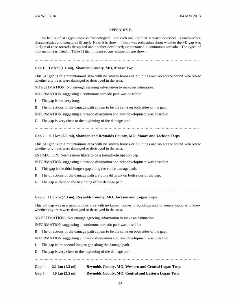
APPENDIX B
The listing of SD gaps below is chronological. For each one, the first sentence describes its land-surface
characteristics and structures (if any). Next, it is shown if there was estimation about whether the SD gap was
likely real (one tornado dissipated and another developed) or contained a continuous tornado. The types of
information (as listed in Table 1) that influenced any estimation are shown.
……….…………………………………………………………………………..……………………………
Gap 1: 1.8 km (1.1 mi), Shannon County, MO, Moore Twp.
This SD gap is in a mountainous area with no known homes or buildings and no source found who knew
whether any trees were damaged or destroyed in the area.
NO ESTIMATION: Not enough agreeing information to make an estimation.
INFORMATION suggesting a continuous tornado path was possible:
L The gap is not very long.
D The directions of the damage path appear to be the same on both sides of the gap.
INFORMATION suggesting a tornado dissipation and new development was possible:
G The gap is very close to the beginning of the damage path.
……….…………………………………………………………………………..……………………………
Gap 2: 9.7 km (6.0 mi), Shannon and Reynolds County, MO, Moore and Jackson Twps.
This SD gap is in a mountainous area with no known homes or buildings and no source found who knew
whether any trees were damaged or destroyed in the area.
ESTIMATION: Seems more likely to be a tornado-dissipation gap.
INFORMATION suggesting a tornado dissipation and new development was possible:
L This gap is the third longest gap along the entire damage path.
D The directions of the damage path are quite different on both sides of the gap.
G The gap is close to the beginning of the damage path.
……….…………………………………………………………………………..……………………………
Gap 3: 11.8 km (7.3 mi), Reynolds County, MO, Jackson and Logan Twps.
This SD gap was in a mountainous area with no known homes or buildings and no source found who knew
whether any trees were damaged or destroyed in the area.
NO ESTIMATION: Not enough agreeing information to make an estimation.
INFORMATION suggesting a continuous tornado path was possible:
D The directions of the damage path appear to be the same on both sides of the gap.
INFORMATION suggesting a tornado dissipation and new development was possible:
L The gap is the second longest gap along the damage path.
G The gap is very close to the beginning of the damage path.
……….…………………………………………………………………………..……………………………
Gap 4 2.1 km (1.3 mi) Reynolds County, MO, Western and Central Logan Twp.
Gap 5 4.0 km (2.5 mi) Reynolds County, MO, Central and Eastern Logan Twp.

JOHNS ET AL. 04 May 2013
24
Gap 6 7.7 km (4.8 mi) Reynolds County, MO, Logan and Webb Twps.
Gap 7 5.5 km (3.4 mi) Reynolds County, MO, Webb Twp.
Gap 8 1.9 km (1.2 mi) Reynolds and Iron County, MO, Webb and Union Twps.
Gap 9 4.5 km (2.8 mi) Iron County, MO, Western Union Twp.
Gap 10 2.1 km (1.3 mi) Iron County, MO, Center Union Twp.
Gap 11 2.6 km (1.6 mi) Iron County, MO, Central and Eastern Union Twp.
Gap 12 2.1 km (1.3 mi) Iron County, MO, Eastern Union Twp.
Gap 13 6.9 km (4.3 mi) Iron and Madison County, MO, Union and Liberty Twps.
Gap 14 17.2 km (10.7 mi) Madison County, MO, Liberty and Center Twps.
Gap 15 3.2 km (2.0 mi) Madison County, MO, Center and St. Michael Twps.
Gap 16 2.4 km (1.5 mi) Madison County, MO, Eastern St. Michael Twp.
Gap 17 2.7 km (1.7 mi) Madison County, MO, Western Castor Twp.
Gap 18 1.6 km (1.0 mi) Madison County, MO, Eastern Castor Twp.
Gap 19 1.6 km (1.0 mi) Madison and Bollinger County, MO, Castor and Union Twps.
These 16 SD gaps were in portions of the Ozark Mountain area with no known homes or buildings in the
gaps. No sources knew whether any trees were damaged or destroyed in the gap areas.
NO ESTIMATION: Not enough agreeing information to make an estimation.
INFORMATION suggesting a continuous tornado path was possible:
D The directions of the damage path appear to be the same on both sides of each of the 16 gaps, and the
line of damage between the start of Gap 4 and the end of Gap 19 is straight.
G All of the gaps appear to be away from the ends of the damage path.
INFORMATION suggesting tornado dissipations and new developments were possible:
L The length of Gap 5, Gap 6, Gap 7, Gap 9, Gap 13, and Gap 14 are >3.2 km (2.0 mi), making tornado
dissipation and new development more probable.
…………………………………………………………………………………………………………………
Gap 20: 2.1 km (1.3 mi), Bollinger County, MO, Union and Whitewater Twps.
Although this SD gap is near the edge of the Ozark Mountain area, it still is hilly, with fewer farms and
buildings than on some nearby flatter ground.
ESTIMATION: Seems more likely to be a tornado-continuous gap.
INFORMATION suggesting a continuous tornado path was possible:
L The gap is not very long.
D The directions of the damage path appear to be the same on both sides of the gap.
G The gap is not near the end of the damage path.
………………………………………………………………………………………………………………..
Gap 21: 1.6 km (1.0 mi), Bollinger County, MO, Whitewater Twp.
Although this SD gap is outside of the Ozark Mountain area, it is hilly, with fewer farms and buildings than
on nearby flatter ground.

JOHNS ET AL. 04 May 2013
25
ESTIMATION: Seems more likely to be a tornado-continuous gap.
INFORMATION suggesting a continuous tornado path was possible:
L The gap is not very long.
D The directions of the damage path appear to be the same on both sides of the gaps.
G The gap is not near the ends of the damage path.
W On both sides of the gap, the damage points were about 0.8–1.2 km (0.5–0.75 mi) wide.
………………………………………………………………………………………………………………..
Gap 22: 3.1 km (1.9 mi) Perry County, MO, Jackson County, IL, Brazeau and Fountain Bluff Twps.
This SD gap is where the damage path crosses the Mississippi River in such a way that much of the gap is
over the river.
ESTIMATION: Seems more likely to be a tornado-continuous gap.
INFORMATION suggesting a continuous tornado path was possible:
L The gap is not very long.
D The directions of the damage path appear to be the same on both sides of the gaps.
W The width of the damage path appears to be >0.8 km (0.5 mi) on both sides of the gap.
G The gap is not near the ends of the damage path.
E An eyewitness on the Illinois side of the river saw the tornado crossing the river as a large, dark mass
that was throwing river water.
…………………………………………………………………………………………………………………
Gap 23: 2.1 km (1.3 mi) Jackson County, IL, Western Sand Ridge Twp.
This SD gap is within the Mississippi River floodplain, an open agricultural area with very few homes or
buildings, as in 1925.
ESTIMATION: Seems more likely to be a tornado-continuous gap.
INFORMATION suggesting a continuous tornado path was possible:
L The gap is not very long.
D The directions of the damage path appear to be the same on both sides of the gap.
W The width of the damage path on the west edge of the gap is 0.8–1.2 km (0.5–0.75 mi) wide. A local
newspaper mentions that the damage path in this part of the county was 0.2–1.6 km (200 yd to 1 mi)
wide.
E An eyewitness saw the tornado moving through the gap.
.………………………………………………………………………………………………………………...
Gap 24: 2.9 km (1.8 mi) Jackson County, IL, Middle Sand Ridge Twp.
This SD gap is within the Mississippi River floodplain, an open agricultural area with very few homes or
buildings, as in 1925.
ESTIMATION: Seems more likely to be a tornado-continuous gap.
INFORMATION suggesting a continuous tornado path was possible:
L The gap is not very long.
D The directions of the damage path appear to be the same on both sides of the gap.

JOHNS ET AL. 04 May 2013
26
W The width of the damage path near the east edge of the gap is 0.8 km (0.5 mi). A local newspaper
mentions that the damage path in this part of the county was 0.2–1.6 km (200 yd to 1 mi) wide.
E An eyewitness saw the tornado moving through the gap.
…………………………………………………………………………………………………………………
Gap 25: 1.6 km (1.0 mi) Jackson County, IL, Eastern Sand Ridge Twp.
This SD gap is in a hilly area where there are not as many farm homes or other buildings.
ESTIMATION: Seems more likely a tornado-continuous gap.
INFORMATION suggesting a continuous tornado path is possible:
L The gap is not very long.
D The directions of the damage path appear to be the same on both sides of the gap.
W On both sides of the short gap, the width of the damage path appears to be 1.2 km (0.75 mi) wide.
…………………………………………………………………………………………………………………
Gap 26: 2.3 km (1.4 mi) Franklin County, IL, Six Mile and Denning Twps.
This SD gap was along a river with not many homes, buildings, or roads.
ESTIMATION: Seems more likely to be a tornado-continuous gap.
INFORMATION suggesting a continuous tornado path is possible:
L The gap is not very long.
D The directions of the damage path appear to be the same on both sides of the gap.
W On the east edge of the gap, the damage points are 1.2–1.6 km (0.75–1) mi wide.
E Four secondhand eyewitnesses knew the tornado was seen while it was within the gap.
……………………………………………………………………………………………………..…………..
GAP 27: 1.8 km (1.1 mi) White County, IL, Phillips Twp.
This SD gap was on the floodplain area on the west side of the Wabash River channel, with fewer homes
and buildings because of occasional river flooding.
ESTIMATION: Seems more likely to be a tornado-continuous gap.
INFORMATION suggesting a continuous tornado path was possible:
L The gap is not very long.
D The directions of the damage path appear to be the same on both sides of the gap.
W Just outside of the floodplain, and about 1.5 mi from the start of the gap, the damage points are
between 1.2–1.6 km (0.75–1 mi) wide. Also, a local newspaper mentions that a 1.2 km (0.75 mi) long
row of trees next to Wabash River and near the end of the SD gap were broken by the tornado.
E An eyewitness saw the large tornado move all the way across the SD gap in the floodplain.
…………………………………………………………………………………………………………..……
Gap 28: 2.3 km (1.4 mi) Posey County, IN, Bethel Twp.
This SD gap was in a floodplain area near Black River. Some interviewees mentioned that almost no one
lived in that area in 1925, as is true now.
NO ESTIMATION: Not enough agreeing information to make an estimation.
JOHNS ET AL. 04 May 2013
27
INFORMATION suggesting a tornado dissipation and new development was possible:
E A local newspaper mentions that two men saw two tornadoes meet and form a giant tornado within the
gap.
INFORMATION suggesting a continuous tornado path was possible:
L The gap is not very long.
D The directions of the damage path appear to be the same on both sides of the gap.
E A local newspaper’s description and an eyewitness each suggest it was a multivortex instead of
multiple tornadoes.
……………………………………………………………………………………………………………
Gap 29: 1.9 km (1.2 mi) Gibson County, IN, Wabash Twp.
This SD gap was in a floodplain area near Black River. Some interviewees mentioned that almost no one
lived in that area in 1925, as is true now.
ESTIMATION: Seems more likely to be a tornado-continuous gap.
INFORMATION suggesting a continuous tornado path was possible:
L The gap is not very long.
D The directions of the damage path appear to be the same on both sides of the gap.
W Within 1 mi of the end of the gap, the width of the damage points are about 1.2–1.6 km (0.75–1 mi)
wide.
E A local newspaper contained eyewitness reports of a very large tornado moving toward the start of the
gap.
…….…………………………………………………………………………………………….…………
Gap 30: 1.6 km (1.0 mi) Gibson County, IN, Center Twp.
This SD gap was in a floodplain area across the Patoka River with no homes or buildings, as probably true
in 1925.
ESTIMATION: Seems more likely to be a tornado-continuous gap
INFORMATION suggesting a tornado dissipation and new development was possible:
G It is more common for the tornado-dissipation gaps to be near the beginning or ending of a long
damage path.
INFORMATION suggesting a continuous tornado path was possible:
L The gap is not very long.
D There is no noticeable direction change associated with the damage points near this gap.
W A local newspaper reported that the tornado path was 0.5 mi wide as it crossed the north–south road on
the west edge of the gap.
E An eyewitness mentioned that cows were able to walk through the area since the tornado had torn
down all of the fences and other obstacles.
N Local newspapers said the Tri-State tornado ended near Oatsville, >1 mi northeast of the gap.
…………………………………………………………………………………………………………………

JOHNS ET AL. 04 May 2013
28
Gap 31: 1.8 km (1.1 mi) Gibson County, IN, Center and Washington Twps.
This SD gap was in a floodplain area across the Patoka River with no homes or buildings, as probably true
in 1925.
ESTMATION: Seems more likely to be a tornado-continuous gap
INFORMATION suggesting a tornado dissipation and new development was possible:
G Tornado-dissipation gaps are more common near the beginning or end of a long damage path.
INFORMATION suggesting a continuous tornado path was possible:
L The gap is not very long.
D There is no noticeable direction change associated with the damage points near this gap.
W At the east end of the gap the damage points suggest that the path was between 0.4–0.8 km (0.25–0.5)
mi wide.
E An eyewitness mentioned that cows were able to walk through the area since the tornado had torn
down all of the fences and other obstacles.
N Local newspapers said the Tri-State tornado ended near Oatsville, >1 mi northeast of the gap.
…………………………………………………………………………………………………………………
Gap 32: 8.1 km (5.0 mi) Pike County, IN, Logan and Washington Twps.
This SD gap was in a farm and mine area with many roads, homes and buildings now, and probably in
1925 also.
ESTIMATION: Seems more likely to be a tornado-dissipation gap.
INFORMATION suggesting a tornado dissipation and new development was possible:
L This gap is longer than any other gap in Illinois and Indiana.
E An eyewitness who lived east southeast of the gap saw a tornado developing (probably a new one)
when he was looking toward the gap.
P In one area where a road crossed the gap, a local person stated that none of the homes were damaged
(non-damage points).
N Some local 1925 newspapers mentioned that the Tri-State tornado ended at Oatsville, close to where
this gap starts. This was corroborated by 1925 Weather Bureau records.
W The damage path continued to narrow across the eastern half of Gibson County and to the start of the
gap in Pike County.
INFORMATION suggesting a continuous tornado path was possible:
D The directions of the damage path appear to be the same on both sides of the gap.
APPENDIX C
Appendix C is available as supplemental material to this paper, hosted by EJSSM at the following web site:
http://ejssm.org/ojs/public/vol8-2/johns_burgess_doswell_gilmore_hart_piltz-2012-layout1-supplement.pdf

JOHNS ET AL. 04 May 2013
29
REVIEWER COMMENTS
[Authors’ responses in blue italics.]
REVIEWER A (Ernest J. Ostuno):
Initial Review:
Recommendation: Accept with minor revisions.
Substantive Comments: Here are some of the specific points I would like to see addressed: In the
abstract it is stated that there have been no formal science papers written about the tornado and its damage
path since the event occurred. The reference section does contain a paper published in the April, 1925
Mon. Wea. Rev. by A. J. Henry, which did include information on the damage path. This paper is not cited
in the text, so I am not sure if the authors have read it. I found the paper in the NOAA library at:
http://docs.lib.noaa.gov/rescue/mwr/053/mwr-053-04-0141.pdf
I think it would be useful to cite the findings of this paper in the Introduction.
We had every intention of citing this paper. Apparently, the citation disappeared at some point in the
revision process during the many drafts of the manuscript, which would explain why it is in the references
but not cited in the paper. This has been corrected, thanks.
I felt the finding that there were separate tornadoes at the beginning of the damage path was not well-
substantiated since it was only based on differing directions between damage points in a gap that occurred
in a sparsely populated area, with very few damage indicators. There are examples of long track tornadoes
that have shown a turn to the right near the beginning of the damage path, such as tornado 13 plotted by
Fujita in the Super Outbreak. The damage path was said to be wide where it picked up again, which would
indicate the tornado had at least reformed somewhere to the west of the eastern edge of the gap.
Although examples of abrupt direction changes in a tornado path certainly can be found, we see no
compelling reason, based on that possibility, to change our interpretation. Our paper provides the
evidence as well as our interpretation of that evidence and we have been careful throughout to make clear
our reasoning for our interpretation. Any reader is free to come to an alternative interpretation of the data
at any point, as we could not justify any absolutely definitive conclusions about any of our findings. We
have modified the text somewhat to clarify this point.
I believe the finding of separate tornadoes for the longer gap at the end of the track in Indiana was well-
corroborated.
I would like to see the issue of the forward speed of the tornado addressed. Many of the references such as
Grazulis mention the remarkable speed of the tornado and cite it as a factor in the huge death toll. Was the
speed steady over its long path or did it change? It would be interesting to see times plotted along the
damage path along with estimated forward speeds at various locations along the path.
We have only a few isolated instances along the track where we have observed times and some those are in
conflict. We appreciate that this might be a significant issue, but given questions of the accuracy of any
such times, we don’t believe our limited data about the timing justify attempting to describe the variations
in the translational speed of the tornado. Rather, we provide what amounts to an estimate of the average
forward speed along the entire path…toward the front of Section 3.
It would also be interesting to see debris fall locations plotted on the maps along with locations where
eyewitnesses saw the tornado moving through the SD gaps such as river/flood plain crossings.
JOHNS ET AL. 04 May 2013
30
It might indeed be interesting, but we haven’t the time or the resources to construction such a map. The
data in Appendix C could be used for this purpose, but it simply isn’t feasible for us to provide it in this
paper.
This may go under the heading of "major revision", but I would like to suggest taking all the eyewitness
accounts in [supplemental] Appendix C and linking them to an interactive map of the damage path. This
could possibly be made into a Google Earth map or something similar, where it would be possible to zoom
into various places along the damage path and click on "eyewitness icons" that would pop up text boxes
with the eyewitness accounts. I feel this would be fully utilizing the capabilities of on online journal. I
found it fascinating, but at the same time exhausting to read Appendix C in one sitting. It would be much
more enjoyable to follow along an interactive map and read the eyewitness accounts while being able to
readily link them to a geographic place.
We have added reference to an interactive map that summarizes all Tri-State tornado damage points. The
reference to the map is located toward the front of Section 3. The map is located at:
http://ejssm.org/ojs/public/vol8-2/map/map.php. Note, however, that the interactive map does not have all
the elements you requested. The map does not contain many of the eyewitness details found in Appendix C
(now, Supplemental Material)…only a summary of information is included on the interactive map.
In Section 4, there is a discussion of the possibility of satellite tornadoes south of the primary damage path.
I have seen several cases of small, isolated areas of damage along the south/southeast side of tornado
damage paths when surveying. Some of these damage areas are worthy of an EF1 rating. They do not
appear to be tornadic and one of the possible causes that has been suggested when I described them in the
past are "occlusion downdrafts". Perhaps this can be mentioned in the text as a possibility?
We have referred to the possibility of such isolated, off-path damage points as possibly being attributable
to satellite tornadoes or “rear flank downdraft” winds (RFD is more general than “occlusion downdraft”)
or inflow winds, but given our limited information, we have chosen not to make such an interpretation of
single, isolated damage points.
Also in Section 4, the case is made for RFD or inflow winds causing lighter damage on the south side of
the damage path, with more intense damage on the north side. Figure 19 is cited as evidence of this. I
found this assertion confusing, since I believe the most intense damage would be not at the north edge of
the damage path, but along the center and just south of the damage path given that the translational speed
would be subtracted from the rotational speed of the vortex or vortices on the north edge.
The text has been modified to clarify this point … the most intense damage would be associated with the
tornado, not RFD winds. Also please see the new Figs. C4 and C5 and the discussion surrounding them.
There are several other questions/comments that are included as annotations in the reviewed document, but
they are relatively minor.
[Minor comments omitted...]
Second review:
Recommendation: Accept with minor revisions.
General Comments: I have gone over the latest version of "The 1925 Tri-State Tornado Damage Path
and Associated Storm System," for E-Journal of Severe Storms Meteorology, including the supplement.
All the main points from the first review were addressed to my satisfaction in the revisions and I
recommend publication as soon as the typos and very minor points are addressed/corrected. See the
attached files.
JOHNS ET AL. 04 May 2013
31
This and the paper by Maddox et al., along with the interactive map of the damage points, will serve as an
outstanding resource for this historic event. It also will be a great reference for future archivists
researching this and other tornado events of the distant past!
Thanks for the opportunity to review these papers.
[Minor comments omitted...]
REVIEWER B (Thomas P. Grazulis):
Initial Review:
Reviewer recommendation: Accept with minor revisions.
Substantive comments: I have a few suggestions that may be rejected by the authors. That rejection
would not be enough to prohibit publication; for it is just personal opinion as a casual reader.
My main suggestion is the inclusion of photographs. If space were an issue, the authors could have done
without much of the appendix material. If size is not an issue in electronic publishing, then why are there
no photographs?…especially of the mounds and depressions so key to the research. Except for a few gaps
such as #3, some other manner of summary would be enough. The details of each gap are fine for the
authors notes, but of little interest to anyone else. They could be made available to someone in the unlikely
event that anyone else would continue this level of research. I understand that the idea of a gap is key to
the concept of a continuous path. But the exclusion of photographs in order the focus on gap details and
lengthy appendix descriptions was not a good idea.
We have added a few representative damage photographs from the event to [supplemental] Appendix C,
but we don’t believe we have enough photographs of journal quality to be comprehensive in providing
photographic damage documentation
Old photographs are not needed. They are available elsewhere. A “before-after” pair of photographs
(1925-current) would be very interesting, [but] that might not be possible unless planned for ahead of time.
Current photographs showing remaining “evidence” of the tornado passage was the very first thing I looked
for when the paper was downloaded. Instead, there were 38 pages of marginally useful appendices that
could have been summarized, organized by type of description. Instead of descriptions of hail (useful to
the authors, I am sure), a map showing the positions of the hail with some conclusions would be far more
useful to the reader. The same goes for the debris descriptions. An author’s comment on the reliability of
406-mile all-time-record piece of debris would be interesting. Was this ever checked in an Ohio
newspaper?
In short: –more maps—fewer words---
Before/after images likely would be interesting, but we have only a few cases where we could do so and it’s
not clear that it adds to the scientific content of this paper. As noted, we have neither the time nor the
resources to convert the data into another map, unfortunately. Two current photos associated with
supposed 1925 tree damage have been added to Appendix C. We do not have comments on the reliability
of the long-distance debris travel. We did not check Ohio newspapers. We hope the large amount of
information in the paper, particularly Appendix C, might be used by others in the future to accomplish
additional research.
I am curious as to why there was no reference to the separate works of Wallace Akin and Peter
Felknor…both spent some time interviewing, although the Akin book has some real problems.

JOHNS ET AL. 04 May 2013
32
The reason we have not cited these non-scientific publications is that we found nothing within them that
would add scientific value to the manuscript.
Photographs might enhance the future “credibility” of this unique work for some people who are unfamiliar
with the authors. For me personally, their credentials and reliability are the highest of anyone alive. But
not everyone knows them, and some may believe that this kind of work is not even possible at a truly
scientific level.
If this is a request for photographs of the authors, it would be an unprecedented addition to a scientific
paper. Moreover, it’s not evident how a photograph could enhance our credibility in the minds of future
readers.
I am delighted to see that this work was done by the level of people who did it. The main text, with clearly
done maps, was excellent. It was those easy to understand maps and text that made me want more from the
appendices. Sorry, when it comes to this historical stuff, I just want more.
No need to apologize … we understand, but a journal paper necessarily has limited scope.
[Minor comments omitted…]
Second Review:
Reviewer recommendation: Accept.
General comments: I have nothing more to say about the paper. I love it and it reads well enough to
publish. I never suggested that credibility involved photos of the authors. My idea was that photos would
add credibility to the idea that this sort of effort could realistically be done at all, and have validity.
I still hope to eventually add something more to knowledge of the day’s events.
[Minor comments omitted...]
REVIEWER C (Gregory S. Forbes):
Initial Review:
Reviewer recommendation: Accept with minor revisions.
Substantive comments: The authors are to be commended for their exhaustive research on this historical
tornado. I have just two comments. One is that the authors may be unaware that there is actually (and
amazingly) aerial damage film of some of the Tri-State tornado path. I believe it is in the National
Archives. I'm not sure, though, that it would make much if any difference to their results. My recollection
is that much of the aerial flight was near Murphysboro, IL.
We have incorporated this suggestion. We had seen the film (in video form) and one of us (Piltz)
painstakingly had used the film to contribute to the data in the vicinity of Murphysboro. A new figure of a
still image made from the film has been added to the paper (supplemental Appendix, Fig. C5), and new
analysis associated with data from the film has been added (Fig. C4). We have not found film from any
other areas than Murphysboro.
The second comment is a suggestion that this group of distinguished authors make a statement, after their
exhaustive study, regarding how long they feel the path of the tornado was. The reader is left to sense that it
might have been 173 mi (or maybe 151, or maybe 130).

JOHNS ET AL. 04 May 2013
33
We understand the interest in such a statement. We have done so, but in a qualified way (see new text
concerning path length in the Abstract and Sections 3–5). Anything definitive is simply not possible, for
reasons which we have explained.
Second Review:
Reviewer recommendation: Accept.
General comments: The authors are to be commended for the amount of effort they have undertaken in
order to gather as much information as possible about this benchmark event in United States weather
history. They have presented the data and their analysis of it very clearly. While it is impossible to
determine the exact length of the continuous tornado path, the reader is guided to conclude that it was most
likely 174 miles, certainly 151 miles or longer. Additional damage, likely from a series of at least 3
tornadoes in a family, covered a path of 235 miles.