th avenue: w 8th w 33 streets 2016 parking protected bike
TRANSCRIPT

Month
Year
6th Avenue: W 8th – W 33rd Streets
New York City Department of Transportation, Transportation Planning & Management
Presented January 7, 2016 to Manhattan Community Board 2
Parking Protected Bike Lane and Traffic Calming 2016

Project Route
Existing On-Street Bicycle Facility
Protected Bicycle Path
Legend
Project Map
2
2

• In 2014, CBs 2, 4 and 5 requested that DOT study the
corridor for a protected bike lane
• Vision Zero calls for an expanded bicycle network in
Manhattan that improves safety for all road users
• Existing bicycle lane between W 8th St to W 42nd St
• Over 2,000 cyclists travel the corridor during a
typical weekday (12-hour period)
• Peak motor vehicle volume is 1,970 vehicles per
hour @ W 27th St
Project Background
3

Why 6th Avenue? Vision Zero Priority Corridor
Vision Zero
Multi-agency effort to reduce
traffic fatalities in NYC
Borough Action Plans released
in 2015
Priority Intersections, Corridors,
and Areas identified for each
borough
6th Ave identified as a Priority
Corridor for Manhattan
6th Ave at W 14th St and W 23rd
St identified as Priority
Intersections
For the complete plan: http://www.nyc.gov/html/dot/downloads/pdf/ped-safety-action-plan-manhattan.pdf
Manhattan Priority Map

5
6 Av: Crash History (2009-2013)
• 6th Avenue is a Vision Zero Corridor
• 6th Avenue and W 14th Street is a Vision Zero Priority intersection
• 32 pedestrians, 11 cyclists and 15 motor vehicle occupants severely
injured in crashes from 2010-2014
Total Injuries
# of people Killed or Severely Injured
KSI = Killed/ Severely Injured
X
Intersection in the top 10% KSI of Manhattan intersections
65
12
23
W 1
7th St
36
W 1
8th St
18
W 1
9th St
25 24
W 2
1st St
19
W 2
2n
d St
23 52 28 35
W 2
6th St
37
W 2
7th St
27
W 2
8th St
37
W 2
9th St
27 29
W 3
1st St
18 33
W 3
3rd St
16 33
3 5 1 0 1 2 0 1 4 2 3 1 1 0 1 2 1 2 3
W 1
4th St
W 1
5th St
W 2
0th St
W 2
3rd St
W 2
4th St
W 2
5th St
W 3
0th St
W 3
2n
d St
W 1
6th St
6th Avenue
22
1
W 1
3th St
21
0
W 1
2th St
15
1
W 1
1th St
14
2
W 1
0th St
1
W 9
th St
28
2
W 8
th St
15

Citi Bike
• 6th Ave is in the heart of the Citi Bike service area
• 11 stations are located near project corridor
6

Wide roadway encourages
speeding and erratic driving
66’ wide street with long
pedestrian crossings
7 6th Avenue @ W 15th Street
Existing Conditions – 6th Avenue
Bike lanes often blocked by
double parked vehicles
Unpredictable maneuvers by
cabs or left-turning vehicles

8
6th Av, 8th – 14th St: Proposed Configuration
Existing Condition
Proposed Condition
9
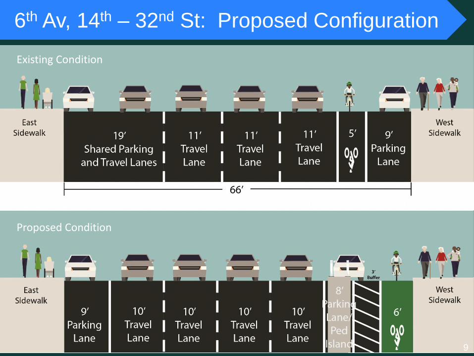
6th Av, 14th – 32nd St: Proposed Configuration
Existing Condition
Proposed Condition

Design Treatments
• Concrete Pedestrian Islands – Shorten pedestrian crossings from 66’ to 49’
• “Floating” Parking Lane – Maintains on-street parking and protects cyclists
• Narrowed Travel Lanes – Calm traffic while maintaining existing number of
travel lanes
Pedestrian Island/“Floating” Parking Lane Concrete Pedestrian Island
10

Design Treatments – Intersections
• Maintain all travel lanes – Mixing zones and split phase turn lanes add
roadway capacity and improve traffic flow
o Mixing Zones – manages vehicle/bike turning conflict while reducing delay
o Split Phase Turn Lanes –protects cyclists from turning vehicles with
dedicated bicycle signal
Mixing Zone Turn Lane
11

1.Improves visibility of pedestrians and cyclists
2.Provides space to negotiate the merge
3.Removes left turns from through lanes
helping to process through traffic
Intersections – Mixing Zones
Typical left
turn design 12

1. Turning vehicles queue for dedicated turn phase
2. Bike lane continues the length of the block
3. Pedestrians and cyclists protected from turning vehicles
4. Used at high conflict locations: W 14th St & W 23rd St
Intersections – Split Phase
13
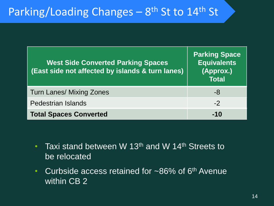
Parking/Loading Changes – 8th St to 14th St
West Side Converted Parking Spaces
(East side not affected by islands & turn lanes)
Parking Space
Equivalents
(Approx.)
Total
Turn Lanes/ Mixing Zones -8
Pedestrian Islands -2
Total Spaces Converted -10
• Taxi stand between W 13th and W 14th Streets to
be relocated
• Curbside access retained for ~86% of 6th Avenue
within CB 2
14

Safety Benefits: Existing Protected Bike Lanes
Columbus Avenue at W 90th St
Three Year Before and After Crash Analysis on Parking-Protected Bicycle Lanes
Change in Crashes w/ Injuries
Change in Total Injuries
1st Avenue E 1st St- E 33rd St
-6% -11%
2nd Avenue E 33rd St- E 24th St, E 13th St – E 2nd St
-11% -7%
8th Avenue Bank St – W 23rd St
-20% -25%
9th Avenue W 33rd St – W 16th St
-43% -46%
1st Ave Before data: 7/1/07-6/30/10 After data: 12/1/10-11/30/13
2nd Ave Before data: 7/1/07-6/30/10 After data: 12/1/10-11/30/13
8th Ave Before data: 8/1/05-7/31/08 After data: 7/1/09-6/30/12
9th Ave Before data: 7/1/04-6/30/07 After data: 11/1/08-10/31/11

• Important Vision Zero Corridor/Area/Intersections
• Enhances safety for all street users
• Installation of a parking protected bike lane with mixing zones and turn
lanes
• Installation of ~33 concrete pedestrian safety islands
• Reduces pedestrian crossing distances
6th Avenue Project Summary
16

Questions? Thank
You
nyc.gov/dot
17