territorial effects of applying the eu “acquis” and community … · prof. grzegorz jerzy...
TRANSCRIPT

RESTRICTED CALL FOR TENDER NO 2002.ESPON.2.2.2
Territorial Effects of Applying the EU “Acquis” and Community Policies as
Well as Pre-Accession Aid and PHARE Lead Partner: Institute for Regional Development and Structural Planning, Erkner, (D) Collaborating Partners:
• European Policies Research Centre, University of Strathclyde - EPRC (United Kingdom)
• Centre for Regional and Tourism Research - CRT (Denmark)
• University Research Institute of Regional Development / University of Social and Political Sciences of Athens (Greece)
• Centre for European Regional and Local Studies, Warsaw University - EUROREG (Poland)
• Centre for Regional Studies of the Hungarian Academy of Sciences - CRS HAS (Hungary)
• Federal Office for Building and Regional Planning - BBR (Germany - ESPON Contact Point)
Part 1: Tender

R E S T R I C T E D C A L L F O R T E N D E R N O 2 0 0 2 . E S P O N . 2 . 2 . 2
Territorial Effects of Applying the EU “Acquis” and Community Policies as Well as Pre-Accession Aid and PHARE
Institute for Regional Development and Structural Planning Address: Flakenstraße 28 – 31, 15537 Erkner, D
Tel: 00 49 3362 793 152 Fax: 00 49 3362 793 111
Dr. Hans Joachim Kujath, [email protected] Dr. Michael Arndt, [email protected]
Dr. Sabine Zillmer, [email protected] Thomas Knorr-Siedow, [email protected]
Table of Contents
1 Summary Presentation of the Tenderer, his Team and the
Consortium 1
2 Information Regarding Conditions of Exclusion 5
3 Information Regarding Selection Criteria 7
3.1 Precise Identification of the Team 7
3.2 Professional Capacity 9
3.3 Technical Capacity 27
3.4 Financial Capacity 32
4 Information Regarding Award Criteria (I) 33
4.1 Knowledge of Regional Policy and the European Spatial Development Perspective 33
4.2 Knowledge of Territorial Impact Assessment 37
4.3 Research Experience in the Research Area (award criterion 2) 40
5 Information Regarding Award Criteria (II) 43
5.1 Research Concept – Aim and Objectives (award criterion 3) 43
5.2 Methodological Approach (award criterion 3) 44
5.3 Suggestion of Territorial Indicators (award criterion 5) 48
5.4 Approach to Territorial Typologies (award criterion 6) 49
5.5 Data Requirements (award criterion 4) 50
5.6 Approach to Recommendations (award criterion 7) 52
5.7 Interaction intended for the thematic co-ordination and networking with other projects (award criterion 8) 53
5.8 Quality of the Project Team (award criterion 11) 54
5.9 Experience of the team in international networking projects (award criterion 12) 56
6 Project Activities 57
WP 1: Methods for Measuring and Presenting Territorial Impact 58
WP 2: Review of EU Interventions and Formulating Initial Hypotheses for the Assessment 60
WP 3: Comparative Analysis of Territorial Development and of Territorial Inputs and Outcomes of Structural Policy 63
WP 4: Comparative Analysis of National Instruments for a Territorial Policy 65
WP 5: Ex Post Analysis of the Influence of Structural Pre-Accession Aid on Balanced Territorial Development in the Candidate Countries 68
WP 6: Ex Ante Analysis of the Influence of Structural Pre-Accession Aid and the Structural Funds on Balanced Territorial Development in the Future EU Territory 69
WP 7: Interreg Initiative’s Impact on Spatial Integration in Terms of Macro-Regions and Cross-Border Co-operation 70
WP 8: Development of Policy Recommendations 72
WP 9: Overall Co-ordination, Interactions with other ESPON projects and presentation of the Output 75
7 Calculated Costs 77
7.1 Lead Partner (IRS) 77
7.2 Collaborating Partners of the Project 80
8 Time Inputs und Table 83
1
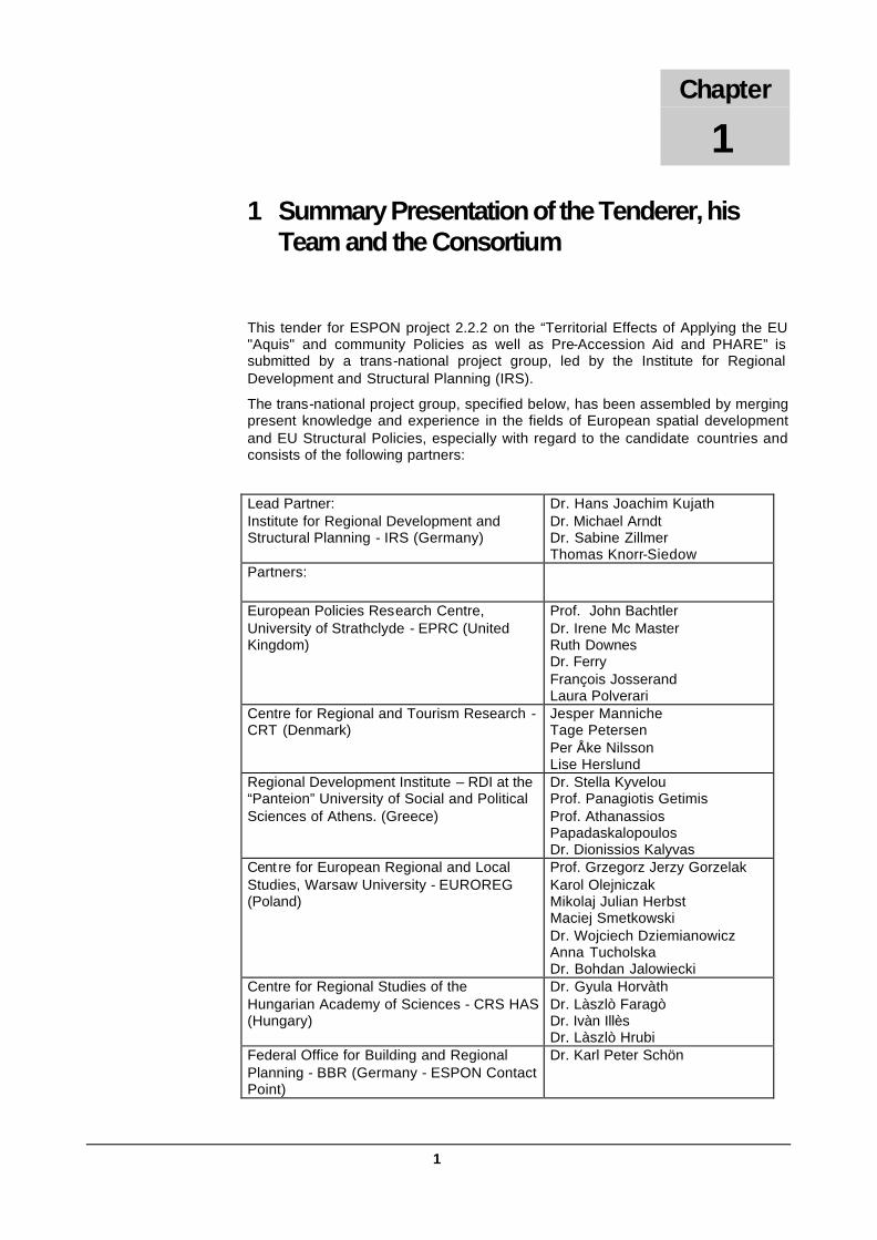
1 Summary Presentation of the Tenderer, his Team and the Consortium
This tender for ESPON project 2.2.2 on the “Territorial Effects of Applying the EU "Aquis" and community Policies as well as Pre-Accession Aid and PHARE” is submitted by a trans-national project group, led by the Institute for Regional Development and Structural Planning (IRS).
The trans-national project group, specified below, has been assembled by merging present knowledge and experience in the fields of European spatial development and EU Structural Policies, especially with regard to the candidate countries and consists of the following partners:
Lead Partner: Institute for Regional Development and Structural Planning - IRS (Germany)
Dr. Hans Joachim Kujath Dr. Michael Arndt Dr. Sabine Zillmer Thomas Knorr-Siedow
Partners:
European Policies Research Centre, University of Strathclyde - EPRC (United Kingdom)
Prof. John Bachtler Dr. Irene Mc Master Ruth Downes Dr. Ferry François Josserand Laura Polverari
Centre for Regional and Tourism Research - CRT (Denmark)
Jesper Manniche Tage Petersen Per Åke Nilsson Lise Herslund
Regional Development Institute – RDI at the “Panteion” University of Social and Political Sciences of Athens. (Greece)
Dr. Stella Kyvelou Prof. Panagiotis Getimis Prof. Athanassios Papadaskalopoulos Dr. Dionissios Kalyvas
Cent re for European Regional and Local Studies, Warsaw University - EUROREG (Poland)
Prof. Grzegorz Jerzy Gorzelak Karol Olejniczak Mikolaj Julian Herbst Maciej Smetkowski Dr. Wojciech Dziemianowicz Anna Tucholska Dr. Bohdan Jalowiecki
Centre for Regional Studies of the Hungarian Academy of Sciences - CRS HAS (Hungary)
Dr. Gyula Horvàth Dr. Làszlò Faragò Dr. Ivàn Illès Dr. Làszlò Hrubi
Federal Office for Building and Regional Planning - BBR (Germany - ESPON Contact Point)
Dr. Karl Peter Schön
Chapter
1

2
In addition, the Nordic Centre for Spatial Development, Nordregio in Sweden, has agreed to closely co-operate with project 2.2.2.
The tenderer comprises a well-qualified, experienced trans-national team of specialist institutes active in the fields of regional development, cross-border co-operation, as well as management and evaluation of EU regional programmes. We are pleased to be able to provide a team with extensive experience of regional policy and European Spatial Development Perspective in the context of Community and candidate countries as well as of the particular aspects of the terms of reference. Already in the past most partner-institutes successfully co-operated in several trans-national research programmes.
Knowledge of candidate countries and neighbouring countries This trans-national project group provides for a number of specifics apart of the knowledge and experience asked for in ESPON project 2.2.2 (see Chapter 4 and 5 on Award Criteria).
• The Institute of Regional Development and Structual Planning (IRS) as the lead partner is very closely located to the candidate countries, especially Poland, the Czech Republic and Hungary, and has therefore close relations in these areas. Furthermore, the IRS is located within the Baltic Sea Region as well as the CADSES area, which are both supposed to be under special recognition in ESPON project 2.2.2. This will be taken care of in a separate Work Package, namely WP 7.
• As of the special role of Poland as a relatively large accession country, the Centre of European Regional and Local Studies (EUROREG) in Warsaw has joined the project group, having widespread understanding of regional and international territorial developments in Poland and its neighbouring countries, particularly of the Visegrad group.
• This is complemented by the experiences of the Centre for Regional and Tourism Research - CRT (Denmark), which has considerable familiarity with regional developments in the three Baltic candidate countries.
• With the partners from the Centre for Regional Studies of the Hungarian Academy of Sciences (CRS HAS) and the University Research Institute of Regional Development at the University of Social and Political Sciences of Athens (RDI), excellent knowledge about the southern candidate countries could be integrated in the trans-national project group. Both have extensive experiences and knowledge in comparative analyses of the respective candidate countries.
• Furthermore, the European Policies Research Centre, University of Strathclyde (EPRC) is a specialist for evaluations and particularly experienced in the evaluation of EU Structural Funds and pre-accession aid in the candidate countries.
• Three partners of the trans-national project group, namely the IRS, EPRC and EUROREG also collaborate in a cross-border evaluation of PHARE CBC programmes, which will certainly lead to synergy effects, concerning the contents and output of ESPON project 2.2.2 but also with regard to organisational matters.
3
Involvement in ESPON network To meet the objective of reaching a common understanding of the development trends of the European territory the project will build on a strong co-operation with other ESPON projects, especially with ESPON Actions 2.2.1 dealing territorial impacts of Structural Funds, with ESPON action 2.1.1, 2.1.2, 2.1.3 addressing territorial impact of sectoral Community Policies (TEN, CAP and R&D). Moreover, in order to develop comparable results for EU 15 and the candidate countries a close cooperation will be intended to ESPON project 1.1.3 dealing with the enlargement of the of the European Union and the wider European spatial perspective. Finally an efficient communication and information sharing between the project team, the ESPON Contact Point, the ESPON Co-ordination Unit and ESPON 3.1 will be established. For this purpose it is of great advantage that most partners of project 2.2.2 are collaborating in other ESPON actions too.
• The EPRC is part of the trans-national project group working on ESPON project 2.2.1, which is very important for the success of ESPON project 2.2.2.
• The Federal Office for Building and Regional Planning - BBR (Germany - ESPON Contact Point) is lead partner of ESPON project 3.1 and partner in the ESPON projects 2.1.1 and 4.1.
• University of Athens is partner in ESPON project 3.1 and further more in the thematic project 1.1.2 “Urban-rural relationships” This collaboration within the ESPON programme will be very helpful for interacting with other projects too, in particular, with the cross section projects under measure 3.
• Taking also into account the planned co-operation with Nordregio, which is the leader of ESPON project 2.2.1 and collaborating in ESPON project 1.1.3, a close co-operation with the other relevant ESPON projects can be ascertained by the trans-national project group proposing this tender.
• These involvement in networking structures of ESPON action will be very helpful for reaching a common understanding and view of the development trends and EU policy impacts, particularly in the candidate countries.
Project co-ordination and shared responsibilities Additionally to the knowledge and experience necessary for conducting the project successfully, the project will have to be managed and co-ordinated smoothly internally, within the trans-national research team, and externally, especially with regard to the other relevant ESPON projects. Correspondingly, co-ordination and management will accompany the whole project and is just included in the work plan as a separate work package (WP 9).
IRS as the lead partner for this tender is fully aware of the contractual obligations accompanying its lead partner status and will therefore ensure, that all tasks are carried out carefully according to the principles of sound project and financial management, deadlines will be met and a clear audit trail will have to be maintained.
In order to sustain the smooth running of the project, a number of organisational measures will be taken including
• close co-operation and communication between the partners using modern IT;

4
• development of clear institutional arrangements where the each partner's responsibilities are pointed out in advance;
• assigning responsibilities for each work package to one partner of the team;
• dedicated staff, who ensures that all tasks are carried out carefully meeting deadlines;
• regular partner meetings, which allow for intensive discussions, especially of potentially arising problems;
• close contacts with other relevant ESPON projects, particularly using modern IT and possibly incorporating them in the partner meetings as far as this seems to be valuable.
• In addition to these measures, out of the overall research team a core team will be established, consisting of the persons, who will be responsible of the work packages. As of the number of involved researchers, this will smoothen the co-ordination between the work packages and therefore represent an additional measure for the project’s co-ordination.
5
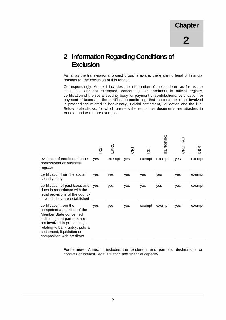
2 Information Regarding Conditions of Exclusion
As far as the trans-national project group is aware, there are no legal or financial reasons for the exclusion of this tender.
Correspondingly, Annex I includes the information of the tenderer, as far as the institutions are not exempted, concerning the enrolment in official register, certification of the social security body for payment of contributions, certification for payment of taxes and the certification confirming, that the tenderer is not involved in proceedings related to bankruptcy, judicial settlement, liquidation and the like. Below table shows, for which partners the respective documents are attached in Annex I and which are exempted.
IRS
EP
RC
CR
T
RD
I
EU
RO
RE
G
CR
S H
AS
BB
R
evidence of enrolment in the professional or business register
yes exempt yes exempt exempt yes exempt
certification from the social security body
yes yes yes yes yes yes exempt
certification of paid taxes and dues in accordance with the legal provisions of the country in which they are established
yes yes yes yes yes yes exempt
certification from the competent authorities of the Member State concerned indicating that partners are not involved in proceedings relating to bankruptcy, judicial settlement, liquidation or composition with creditors
yes yes yes exempt exempt yes exempt
Furthermore, Annex II includes the tenderer's and partners' declarations on conflicts of interest, legal situation and financial capacity.
Chapter
2

43
5 Information Regarding Award Criteria (II) Information regarding the technical quality of the tender in relation to the services required has to be judged in the light of activities and comments presented in chapter 6 “Project Activities”. Therefore, following information will highlight issues regarding the award criteria for the different elements of ESPON project 2.2.2. This will be undertaken with reference to the respective Work Packages and detailed commentaries on “Project Activities” in chapter 6.
5.1 Research Concept – Aim and Objectives (award criterion 3)
The core aim of territorial cohesion forms the overall framework for territorial impact assessments of European policies. Thus, this project 2.2.2 is based on the principals of territorial cohesion as common ground for action. Relations to the other policy aims of EU cohesion policy (economic and social cohesion) and to the aims of European spatial policy will also be kept in focus. The policy guidelines laid down in the European Spatial Development Perspective (ESDP) “polycentric and balanced spatial development in the EU”, “parity of access to infrastructure and knowledge” and “wise management of the natural and cultural heritage” will certainly also serve as starting-points. Issues highlighted in the second report on economic and social cohesion, such as the challenges posed by the existing centre-periphery model, the function of cities as growth engines, developments in rural areas, border regions and areas with specific geographic features will also be important elements to promote a more balanced and more sustainable development of the European territory. Especially for the enlarged EU these issues will be of great relevance.
For a better understanding how to overcome and prevent territorial disparities within the EU and the candidate countries, ESPON comprises thematic research on the principal territorial trends at EU scale and on the territorial impacts of sector and structural policies. With territorial impact assessment of Community sector policies and the states´ spatial development policies some integrated tools and appropriate instruments to improve the spatial co-ordination of sector and spatial policies are expected. ESPON Project 2.2.2 intends to help fulfilling this research requirement through an analysis of the territorial impacts of the pre-accession aid and the PHARE Programme as well as of the applications of the EU „Acquis“ and relevant Community Policies. Through co-ordination and networking with other projects in the ESPON programme, (particularly, those also focussing on policy impacts, in particular project 2.2.1, 2.1.1, 2.1.2., 2.1.3 addressing territorial impact of Community Policies as there are Structural Funds, TEN, CAP and R&D) the project will add to the programme’s aim of providing a strong scientific basis on which future EU policy developments in the candidate countries can be based.
Within this overall aim, the following specific objectives have been set:
a) To develop a method for the territorial impact analysis of pre-accession aid and the PHARE programme as well as for the application of the EU „Acquis“ and relevant Community policies;
b) To establish a set of indicators, typologies and concepts along with a database and the map-making facilities necessary to implement the territorial impact assessment (TIA) method;
c) To provide a structured presentation of the Community Policies identifying the relevant parameters for an assessment of its potentially differential impact across the candidate countries;
Chapter
5

44
d) To apply the TIA method in order to show the impact of these policies on spatial development across accession countries at the NUTS III or equivalent scale;
e) To investigate the interplay between the EU policies, national spatial policies and best examples of implementation;
f) To recommend further policy developments for the support of territorial cohesion and a polycentric and better balanced territory, with focus on the candidate countries.;
g) To find appropriate instruments for the improvement of spatial co-ordination of EU sector policies as stated in the ESDP;
h) To consider the provisions made and to provide input for the achievement of the horizontal projects under priority 3.
5.2 Methodological Approach (award criterion 3)
An important task for all ESPON projects dealing with territorial policy impact analysis is to develop an appropriate methodology for analysing the EU sector policies. In order to find a common methodological basis, project 2.2.2 will work out the details of the methodology in close co-ordination with other ESPON projects. Strong co-operation will particularly be built with ESPON project 2.2.1 in order to avoid different methodological approaches in EU-15 (project 2.2.1) and the candidate countries (project 2.2.2) as well as incomparable results of both projects. We will try to get comparability by means of the European Policies Research Centre (EPRC) who is going be a central partner in both projects. The EPRC is specialised in assessing territorial impacts of structural funds programmes and involved in of a lot of EU structural funds evaluation projects, partly in collaboration with other members of the project-team (EUROREG, IRS, CRS HAS). It will take on similar responsibilities in both projects. Furthermore Nordregio, the lead partner of action 2.2.1, and the IRS have come to agreements that enable both projects to develop the steps of research in close connection. For more information regarding methodological approaches see chapter 6, work packages 1 and 2.
Experience with Territorial Impact Assessment (TIA)
The concept of Territorial Impact Assessment (TIA) has been brought into the European debate as part of the process of co-operation regarding the European Spatial Development Perspective (ESDP). It was also particularly emphasised in the ESDP Action Programme agreed upon at the Tampere Meeting in 1999. To date, however, TIA has neither been defined nor carried out at European level. As a first step, the method for the assessment can be set up on the base of the experience of Structural Funds evaluation and the considerations by the UK delegation of the Committee on Spatial Development (CSD) concerning the scope of TIA as a valuable tool for assessing the impact of development programmes and policies against spatial policy objectives and prospects. At this stage the methodological approach would base on the extensive experience of the European Policy Research Centre (EPRC) participating in the consortium. Some elements for the evaluation techniques used in the EU (see DG Regio Working Papers 3&7, MEANS Collection), will lead to a more precise specification of TIA. These elements can help to develop an appropriate method of assessing the measurement of policy achievements against selected criteria of territorial social, economic, environmental and institutional developments. Some elements from the EU guidance should be included in modified form, namely:
• The assessment of the relevance of the Community Policy objectives to the actual needs in each candidate country referring to certain spatial planning goals (relevance);
• The comparison of the actual results of the Policy with what was planned relating to the spatial planning goals (effectiveness);

45
• The appraisal of the Policy impact on the fulfilment of target group needs (utility);
• Consideration of the long-term effects and side effects (sustainability).
Methodology of Ex post and Ex ante Analysis and Assessment
The territorial impact assessment in project 2.2.2 will consist of two chronological steps
• Assessment of the territorial policy impact of the pre-accession aid and the PHARE programme (ex post assessment)
• Assessment of the spatial impacts of the future application of pre-accession aid and Community policies (Structural Funds and Cohesion Policies, Ten, CAP, ENERGY and R&D) (ex ante assessment , assessment of scenarios).
Ex post assessment will give answers to the question whether the social and economic geography in the candidate countries has changed dramatically in result of EU und national policies during the last decade, or remained, in principle. As territorial change is likely to proceed with more dynamic in the candidate countries producing new patterns of disparities and new types of regional problems, regional impacts of future EU interventions, however, will be of great importance, too. We are considering that the ongoing transition process in the candidate countries occurs in a wide corridor of development options and by this, more space will exist for alternative development policies than it is the case in the EU 15. Against this background ex ante appraisal shall critically assess the proposed aims, priorities and expected results of structural policy with regard to the social, economic and territorial consequences of the policy principles and measures undertaken in the future. In particular, it shall provide a better understanding of policy measures with regard to different types of regional structure in the candidate countries. It may be able to give information whether and to what extend regional and sector intervention will particularly affect regions which are on the edge of social, economic and sometimes environmental decline (old industrialised regions, peripheral rural regions). Thus, ex ante evaluation will indicate whether the policy priorities and measurements are appropriate in stimulating territorial balance and will provide recommendations on amendments and realignments to these policy structures.
Methodological Tools
Assessing the impacts of the EU enlargement on the territory of the E U and the other regions is an extremely complex and hazardous task. There is a great degree of uncertainty on a number of important factors that will directly determine those impacts, while indirect effects, could be as important as direct ones, are even more difficult to estimate. The impacts of the enlargement will very much depend on the economic performance of the EU, on the economic performance of the candidate countries, but also of the other regions and external effects. Moreover, these impacts will as well depend on the future form of the EU policies, in particular the Common Agricultural Policy and Structural Funds. Given the complexity of assessing the impact of enlargement, we need a coherent framework that can take all the fundamental direct and indirect sectoral and regional feedbacks into account. For this task we will stress on different descriptive and causal analytical tools to measure EU Policies’ territorial impacts. Five methodological tools will be applied to conduct ex post and ex ante analyses of the EU policy impact within the candidate countries and their interrelation with the development in neighbouring EU member states.
(1) Meta-Evaluation and Working Hypotheses on Spatial Effects of EU Policy
Foundations for policy impact analysis and assessment will be laid by building working hypotheses with regard to the impacts of past, current and future EU policies on territorial and regional cohesion within an enlarging EU. This working hypotheses on spatial effects will be derived by working out well-founded considerations on causal linkages between EU policy

46
and spatial effects with respect to the three main targets of the ESDP: polycentric spatial development, a new urban-rural relationship and parity of access to infrastructure, wise management of natural and cultural heritage. They shall deliver first explanations of the current situation as well as explaining scenarios of future spatial outcomes. Thus, the formulation of working hypotheses on the territorial implications of EU policy can be interpreted as qualitative meta-evaluation or first qualitative insights into the EU Policies´ effect. They will the basis for “Structural Equation Modelling (SEM) ”which will be used in the following as a tool for interpreting the results of descriptive territorial analysis. Using the following tools of applied methodology we will test the results of this first assessment.
For more information see chapter 6, work package 2.
(2) Measurement of EU Policies Impact on Spatial Cohesion
Keeping in mind the complexity of factors influencing spatial development this tool concentrates on policy impacts on spatial cohesion. Its aim is to identify trends of territorial development with regard to economic territorial disparities. Initially, we start with a descriptive methodology, which lays emphasise on the correlation between regional cohesion indicators as employment and income growth and the policy input. Comparing the economic results and substantiating different regional degrees of economic performance in relation to EU policies, we will be able to draw first conclusions on the territorial effects of EU policies. Furthermore, we will be able to use these results for differentiating groups of regions, i.e. a typology of regions, with a high homogeneity in terms of the indicators used by running a statistical cluster analysis. Variations among clusters and their inter-temporal changes will show the differentiation in terms of regional economic performance and policy inputs.
For the interpretation of the descriptive results, we suggest to analyse the relevance of causal relations taking into consideration various other factors by using cross sectional statistical modelling techniques such as structural equation models (SEM) – if data allow for it. SEM seems to be suited dealing with latent rather than manifest variables is used to measure the behaviour of these variables. Policy variables are belonging to this type of variables because we can observe their behaviour only imperfectly through their effects on manifest variables like socio-economic outcomes. As the overall aim of the project is to give policy recommendations regarding territorial policy, it will be advantageous to stretch the analysed interrelationships to the future as well. For this purpose continuing the observed time series in the future and developing probable socio-economic developments by the utilisation of SEM and scenario techniques will conduct ex ante an analysis.
More information you can find in chapter 6, work packages 5 and 6.
(3) Measurement of EU Policies Impact on Territorial Specialisation
In order to measure the impact of EU enlargement and of different EU policies in the candidate countries on spatial concentration and dispersion of economic activities and territorial division of labour we also suggest to take two methodological paths: We first use a descriptive methodology measuring the time changes of territorial division of labour, e.g. the concentration of industrial activities and structural changes of agriculture, in comparison to the geography of EU policy, especially structural spending. In difference from the suggested territorial socio-economic impact analysis, in this case, we derive results by measuring processes of spatial relocation of functional economic activities, i.e. inter-temporal changes of industrial, service, agricultural etc. activities within the observed territorial units. This way, a descriptive typology of regions in terms of functional specialisation in relation to the role of different behaviours of EU policies can be provided. As there are to assume strong relationships between the spatial socio-economic impact and the spatial specialisation impact a descriptive relationship between both, the typology in terms of cohesion indicators and the typology in terms of specialisation indicators, can be provided.

47
Structural equation modelling in this context will take on the same interpretative role as in the second context above. Moreover, we consider combining the variables of both approaches by SEM will be feasible and will help to gain a comprehensive overview of the causes of different regional developments. We intend to conduct such SEM – if data allow for it.
More information you can find in chapter 6, work packages 5 and 6.
(4) Measurement of Interreg-Initiative’s Impact on Spatial Integration
There are close linkages between what happens within regions and what happens between them. For this reason special attention will be paid on interregional linkages particularly on cross border relations within European macro-regions. European macro-regions are for example the “Northern Periphery”, the “North West European Metropolitan Area”, “Alpine Space”, the “Baltic Sea Region and the CADSES (Central European, Adriatic, Danubian, South-East European Space)” which are important areas for planning, contribution of structural funds and evaluation1. Interreg IIC and IIIB initiatives as well as PHARE -CBC programmes – both are aiming to promote cross-border inter-relations - will be evaluated on their ability to further promote cross-border integration. Intrinsic to this analysis is the general hypothesis that these initiatives are launching a new approach to territorially designed European regional policies and lead to the emergence of new trans-national inter-related areas. This implies that cross-border integration is not analysed only from a national or European perspective, but with respect to local and regional circumstances (formal and informal barriers between nation states), institutional capacities and interaction. Analysis and assessment of regional co-operation may be suitable to discuss to what degree the Interreg initiatives will be able to promote the emergence of new types of trans-national regionalism and its institutional outcomes on sub-national levels. In addition, this analysis may examine to what degree territorial policy aims, such as polycentric development or rural-urban partnership will become important issues for local and regional actors and representatives.
With respect to the aim of EU Policy to facilitate the integration of the candidate states and future member states, the analysis will focus on both macro-regions, namely the Baltic Sea Region and CADSES, as they include regions from candidate countries. Analysis and assessment of regional co-operation within these two trans -national macro-regions may be suitable to discuss to what degree the Interreg initiatives will be able to promote the emergence of new types of trans-national regionalism and its institutional outcomes on a sub-national level.
To study the effects through EU initiatives which are stimulating local and regional actors within trans-national programming areas, we also rely on the instruments of descriptive and interpretative methodology – if possible on SEM. It seems rational to use for a descriptive approach two indicators, namely the change of EU policy (Interreg and PHARE -CBC) measured according to expenses in different policy categories and the change in the forms and/or the level of co-operation in the respective border regions. This way, different kinds of regions might be detected, showing different levels, respectively changes in EU policies and different intensities in co-operation. When these differences between regions are detected, the respective regions can be analysed according to their socio-economic characteristics, searching for explanations of different outcomes. This way, it will be possible to give a descriptive relationship between spatial EU policies and cross-border co-operations, which would than have to be presented on maps.
More information you can find in chapter 6, work package 7.
1 For example see: Bachtler, John, et al (2000): Interim Assessment of the Interreg IIC Baltic Sea Programme, EPRC, Glasgow; Arndt et al. (2002): Evaluation of Conditions and Opportunities for Future Co-operation Patterns in the Field of Spatial Planning in the "Baltic Bridge" Area (Berlin – Szczecin -Skåne), Interreg IIC 2002, IRS, Erkner.

48
(5) Case Studies on Regional Effects of EU Policy
The three previous analytical tools will be able to give a first description and causal explanations for different regional outcomes of both EU and national policy with regard to regional development and territorial balance. They will be able to identify, where similar pre-accession measures lead to different results, i.e. spatial cohesion or possibly increasing divergence. Furthermore, these analyses show how EU structural programmes may contribute to a balanced and polycentric development of an enlarged EU in the future.
In addition to this general analysis it will be beneficial to conduct very precise case studies on a few selected regions, in order to get deeper insights into the mechanisms affecting territorial development. This methodological step will be similar to the intended case studies by project 2.2.1. However, project 2.2.1 lays its main focus on the EU 15, whereas our focus lays on regional “cold” and “hot” spots in the candidate countries. We will put special attention to the most disadvantaged and most prosperous regions in the candidate countries – peripheral rural regions, old industrialised regions, border regions and the metropolitan growth poles. Detailed case studies of these regional types will make it possible to single out the specific causes for different developments and the specific role of selected EU programmes in this context. The specific case study areas will be selected in order to reflect for instance differing degrees of peripherality, differing population dynamics, differing dependence on agriculture and/or industrial dynamics of regional economies.
This part of the project will test explicitly the extent to which EU policies serve to promote or hinder territorial development at the local level. Detailed regional case studies will also allow identifying contrary effects in relation to policy interventions. Negative outcomes may pull off effects for promoting a better accessibility of a rural region. Direct investments may offer new jobs within the region, however they may not stimulate endogenous growth, but external income-flows to the region. Finally, transport policy as well as R&D policy may be beneficial for the main agglomerations excluding peripheral regions from the general economic development. Thus, we can find out possible side effects of structural intervention, which do not always influence territorial balance in positive ways. Within this context we will be able to analyse the different EU and national funds and their effects on regional development as ISPA, SAPARD, PHARE during the pre-accession phase and Structural Funds, CAP etc. after accession.
More information you can find in chapter 6, work packages 5 and 7.
5.3 Suggestion of Territorial Indicators (award criterion 5) The following considerations concern the choice of variables that can serve as indicators for this project. Indicators will be differentiated into input and impact indicators. The former relate to data describing the initial conditions in the regions under examination. As starting point, the years 1989/90 will be taken as reference, depending on the beginning of transition. Furthermore, these indicators comprise political measures, as they are inputs to regional developments. The impact indicators relate to economic processes, which in combination, lead to economic and environmental changes and to impacts of the EU policy. As this project aims to distinguish between ex post and ex ante analyses, it seems logical also to divide the indicators accordingly. Therefore, policy impacts will be distinguished according to whether they have been in the past (after the beginning of transformation) or are related to the future, where they can be influenced, to some extent at least. In the following, a first preliminary list of indicators is given. An elaborated list of indicators will be added in the course of the project.
Input indicators will take into account subsequent groups of indicators, such as:
• Physical initial situation • Accessibility preconditions • Socio-economic preconditions • Pre accession EU and national policy inputs (ex post and ex ante) • Policy inputs after accession (ex ante)

49
• PHARE programmes from 1989 to 1999 (ex post) • Structural Interventions between 2000 and 2002 (ex post) • Programmed Structural interventions for 2002-2006 and with special regard to expected
Structural Interventions after the accession of ten candidate countries (2004) (ex ante) • Implementation of EU “acquis” (ex post and ex ante) • National instruments for a territorial policy (ex post and ex ante).
As far as possible, policy inputs will be measured in monetary terms. However, it might be difficult, and perhaps sometimes impossible to assign specific changes in the socio-economic potential of the regions and localities to inputs made within particular Programme’s projects and modules. Instead, one may be forced to limit the conclusions to “soft” indications of such relationships and to formulate the findings in a probabilistic way, and not in a form of definite statements.
The terms of reference mention a useful list of impact indicators describing territorial and regional impacts like:
• Regional economic indicators including gross domestic product, gross value added and employment by sector, unemployment, regional transfers
• Regional population indicators including population, educational attainment and labour force participation as well as indicators for classification of the regional settlement system
• Connectivity, accessibility and decongestions • Regional attractiveness including indicators of quality of life and indicators of
environment. • Direct physical outcomes of policy measures.
These will be used as a starting point for developing a set of measurable impact-indicators, which will be distinguished with respect to the kind of territorial impact to be measured. Thus, indicators measuring the impacts on economic activities, the sectoral structure of an economy, as well as on population, migration, the labour market, connectivity and environment will have to be elaborated.
Moreover, all indicators have to take into account the intentions of measuring the effects on spatial cohesion, spatial specialisation and spatial integration as described in chapter 4.2.
5.4 Approach to Territorial Typologies (award criterion 6) Based on the descriptive methodology and indicators for the quantitative measurement of spatial impacts, it will be relatively easy to define groups of regions with a high homogeneity with respect to the territorial effects of EU policies, i.e. with similar expected socio-economic and environmental responses to a specific policy mix. As stressed out in chapter 6.2 cluster analysis will be a suitable instrument to form groups of regions, which show a similar behaviour in terms of economic performance and policy measures adopted. In this context, special attention will be paid on multidimensional concepts of generating similar types of regions. Apart from identifying groups of regions by means of cluster analysis using quantitative indicators, we intend to complete this typology with qualitative indicators, which will be matched with the quantitative analysis. This way, the description of spatial implications of the EU policy mix can contain a broader variety of indicators and will be able to give deeper insights in differing regional situations and developments.
As outlined in the previous chapter, typologies will be elaborated with respect to the policy impacts on
• Spatial cohesion (equity)
• Spatial specialisation (efficiency)
• Trans -national territorial integration.

50
For each impact criterion the appropriateness of using multidimensional indicators, for example combined income levels and unemployment indicators for cohesion, will be checked.
This will be done in close co-ordination with the other ESPON initiatives on territorial policy impacts
5.5 Data Requirements (award criterion 4) The methodology approach outlined in chapter 5.2 and the elaborated indicators have specific data needs. The following considerations present some data requirements with regard to the temporal and spatial scope as well as to the data groups. Furthermore, data requirements for ESPON project 2.2.2 will have to pay considerable attention to data categories used by the ongoing projects under the ESPON action. In order to avoid duplication efforts, we will concentrate our efforts for data collection on the candidate countries. Statistical data from the candidate countries are often incomplete and poorly comparable with data sets of EU 15. In these cases data adjustment will be necessary, as far as possible. As most relevant data have to be gathered in the candidate countries, we are fortunate to be able to call upon experts of EUROREG and CRS HAS research institutes from the candidate countries who have considerable experience in the field of data gathering within their own country and their neighbouring candidate countries as well.
For further information with regard to data requirements see chapter 6, work packages 2, 3 and 4.
Spatial Level of Data
The NUTS III regions defined for the EU member states, equivalent regions in the candidate countries and comparable regions in Norway and Switzerland are the regions of the database also used in the other ESPON projects. However, often data for NUTS III level are not available. Thus data for NUTS II and NUTS I regions have to been disaggregated to NUTS III regions, if possible, in order to generate comparability of data between regions and countries. Particularly in the candidate countries comparability often may be judged insufficient. Thus, the question how to generate regional data of the candidate countries which will be comparable to data from other data sources will be one of the challenges to project 2.2.2.
Temporal Dimension of Data
Statistical data are supposed to be collected for the time period from 1989 – 2002. This will provide an adequate basis for time series analysis.
We know, that gathering of time series-data will be an ambitious undertaking as many of the candidate countries have changed their territorial administrative structure and their statistical units as well as data gathering and provision. This is the case in neighbouring regions of East Germany too. In order to generate data sets that can be used to analyse and assess EU policy impacts on territorial cohesion and balance in the candidate countries in comparison to the EU 15 and discuss the effects of EU enlargements, adjustments of data will be necessary in many cases. Measures applied for the adjustment of data will be co-ordinated in close connection with other ongoing projects under ESPON actions.
Data on Territorial Impacts
Territorial impact assessment needs data, that are able to measure the impacts of EU as well as national policy affecting territorial development. Like in the other ESPON projects, data will predominantly be gathered at the NUTS III level.
51
Data of Relevant Policies
The territorial impact assessment of EU policy, particularly in the candidate countries, has to consider two groups of data: data concerning the policy dimension and data, which inter-relate with EU policy describing territorial development. Data collection of policy relevant indicators needs to operate with both, quantitative and qualitative data, which might result in difficulties in precise evaluation of EU intervention. Measurable data may be for example interventions which can be valued in monetary spending at the input side and in physical terms at the output side, as is outlined in work package 3. But there are also several identifiable policy instruments, which have to be described with qualitative data. This applies to the institutional context, which influences vertical interaction between policy, polity and politics as well as horizontal co-ordination between different Community policies. As outlined in work package 4, we are aware that differences in the responsibilities of national policies in relation to the regional responsibilities as well as the degree and the way of implementation of EU “acquis” by the candidate countries will more or less affect spatial development, too.
Data Sources
As pointed out, the availability of data will be of crucial importance for applying the methodology of territorial policy impact assessment particularly with regard to the candidate countries and the inter-relations between candidate countries and neighbouring countries in the process of EU enlargement. In work package 1 we recommend four groups of data depending on resources of requirement:
• A “standard set” of statistical data referring to those indicators that are harmonised European wide at NUTS II and III level. Such indicators are also used by other ESPON projects and are mostly available at EU level. They comprise socio-economic and environmental data as well as data with regard to Structural Funds programmes.
• Depending on the institutional system in each country more or less statistical information will be gathered from national statistical offices, from national Ministries of Environment, Social Affairs, Trade and Commerce etc. and from the national authorities dealing with EU policy and management of EU Funds. Specific indicators for ex ante assessment related to the application of Community policies (Structural Funds and Cohesion Policies, TEN, CAP, Energy and R&D) and for ex post assessment related to the pre-accession policies (ISPA, SAPARD, PHARE and EU „acquis“)will predominantly be collected from national sources. This involves special data on the amount of Funds spending and the information by National Development Plans and Programmes for the Adoption of Acquis.
• In countries with institutionalised strong regional governments, as for example in Germany and Poland, we will be able to gather data on socio-economic as well as EU policy development from regional authorities.
• Indicators dealing with more detailed data will be collected for certain areas. These indicators will be able to give special information about the correlations between the regional implementation of programmes affecting a region and the spatial development of that region. In this case, particularly regional data sources will be required for deeper analysis of the causal effects of EU policy for certain types of regions as peripheral rural regions, old industrialised regions or border regions and dynamic city regions. The respective case studies require a wide range of data collected during field and desk research as for example official documents (regional and local strategic plans), available regional analyses and reports in addition to local and regional statistical data-sets.
All information and data collected will be gradually set or transferred into the created database. This database will be build in close linkage to the work of other ESPON projects, especially ESPON 2.2.1, which refers to our own project in several respects. To find out the required data sources in the candidate countries we will get great support by our team partners from the candidate and neighbouring countries: Poland, Hungary, Germany, Greece, Denmark. For further information with regard to data requirements look at chapter 6, work packages 2, 3 and 4.
52
5.6 Approach to Recommendations (award criterion 7) The recommendations will take account of the strong policy scope of this study, which means that all work packages of the study will support policy recommendations referring to the policy options outlined in the ESDP. Proposals will put the main emphasis on topics as following:
Improved Methods of Territorial Policy Impact Assessment
As outlined in work package 8 of the project activities results of data gathering, analysis and policy assessment shall be brought together in recommendations for improvements of the methodology to assess territorial impacts of pre-accession aid and PHARE as well as EU “acquis” and the impacts of EU policies after accession. These recommendations shall include a set of operable reference indicators of territorial impacts of EU policies in the candidate countries. By this means, a better design and implementation of such policies shall be derived.
Within this context, a manual for gathering the necessary databases and for the application of scenarios in connection with ex ante assessment will be provided.
Improvement of the Methodology to Select Eligible Areas
Further recommendations will be made for the improvement of the methodology for selecting eligible areas for EU policies including cartographic tools for presentation of the territorial impacts. To serve this particular purpose the application of symbols and codes for mapping qualitative and quantitative data will help to select types of regions and eligible areas.
Models of Policy Mix for Different Types of Regions
Last but not least, recommendations aim at EU policies itself, giving advice on reformulating EU sector policy instruments and their relation to national policies in order to improve promotion of territorial and regional balance. Recommendations will be particularly focussing on the nested results of policy impact analyses of the most disadvantaged regions like peripheral rural regions, which are not only located at the Eastern geographic periphery of the enlarged EU, and old industrial regions suffering of the ongoing economic transition process. Recommendations will be centred on how to orientate EU policy, polity and politics supporting national measures against growing unemployment and economic difficulties by means of structural reforms in agriculture and heavy industries.
Examples of good practice will serve as basis for modelling regional programmes and spatial plans integrating Structural Funds, Cohesion Funds, sector policies and national policies referring to different types of regions.
Improvement of Institutional Settings
In several work packages of the project activities (work packages 2, 3 and 4) institutional settings will be discussed with respect to their support for or hindrance of the co-ordination of EU structural policies, national and regional programmes with regard to spatial planning. The proposals will address issues of horizontal co-ordination between different sector policies, such as regional and cohesion policy, environmental policy, common agricultural policy, internal market policy, competition policy with respect to the guidelines and priority actions of ESDP. Furthermore, it will also focus on issues of vertical co-ordination between EU-level, national level, regional level and local level.
57
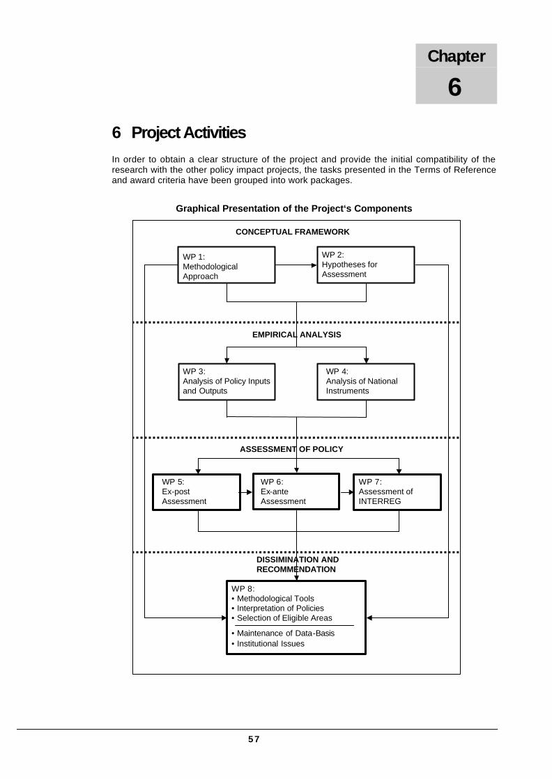
6 Project Activities In order to obtain a clear structure of the project and provide the initial compatibility of the research with the other policy impact projects, the tasks presented in the Terms of Reference and award criteria have been grouped into work packages.
WP 1: Methodological Approach
WP 2:Hypotheses for Assessment
WP 3:Analysis of Policy Inputs and Outputs
WP 4:Analysis of National Instruments
WP 5:Ex-post Assessment
WP 6:Ex-ante Assessment
WP 7:Assessment of INTERREG
WP 8:• Methodological Tools• Interpretation of Policies• Selection of Eligible Areas
• Maintenance of Data-Basis• Institutional Issues
DISSIMINATION AND RECOMMENDATION
ASSESSMENT OF POLICY
EMPIRICAL ANALYSIS
CONCEPTUAL FRAMEWORK
Graphical Presentation of the Project‘s Components
Chapter
6

58
WP 1: Methods for Measuring and Presenting Territorial Impact
Key Tasks Key Partners No of Days Months
(1) Developing a methodology of territorial policy impact analysis in co-operation with other ESPON projects in particular project 2.2.1
(2) Identification of appropriate indicators, taking into account the proposals by other policy impact projects
(3) Search of data sources and compiling a comprehensive list of data sources
IRS, EPRC, CRT, RDI, EUROREG, CRS HAS, BBR
85 2
Deliverables:
(1) Methods for ex post and ex ante territorial impact assessment of EU policies taking particularly into account the deliverables of project 2.2.1
(2) Set of indicators necessary for measuring territorial impacts of EU interventions
(3) Comprehensive list of available statistical sources in particular from the candidate countries
Timescale: Months 1-2
This WP covers activities, which will evolve a methodology for a socio-economic analysis of the policy impacts on territorial developments in each candidate country and between them. The consortium will conduct it with EPRC’s close co-operation in action 2.2.1. Activities necessary for the completion of WP1 are therefore:
Method for Territorial Impact Analysis and Assessment
The aim is to develop a tool for comprehensive presentation of institutional settings, according to which actors in the different candidate countries adopt EU policy in national policies and conduct them on regional level. There seem to exist strong relations between the adaptation of EU requirements and standards (EU „Acquis“) and outcomes of EU policy on regional levels, too. The method of assessing the measurement of policy achievements will be outlined on basis of selected criteria. The criteria will relate to the main issue of regional social cohesion/segregation and should contain for instance
• regional economic indicators including sector structure indicators;
• indicators of regional population development;
• labour market indicators;
• connectivity and accessibility indicators within the new international setting;
• regional equipment with infrastructure;
• indicators of regional attractiveness as quality of life, social services, environmental situation etc.
• indicators of regional equipment with R&D.

59
Variables and Indicators Measuring Territorial Cohesion/Disparities
The aim is to identify those variables and indicators with which it will be possible to assess territorial development in the light of the policy aim of territorial cohesion. Following the suggestions of project 2.2.1 we will develop three types of variables:
• A “standard set” referring to those indicators that are harmonised Europe wide. Such indicators will also be used by other ESPON projects and are mostly available at EU level.
• Specific indicators for ex ante assessment related to the application of Community policies (Structural Funds and Cohesion Policies, TEN, CAP, Energy and R&D) and for ex post assessment related to the pre-accession policies (ISPA, SAPARD, PHARE and EU „acquis“). Data for these indicators will be collected from national sources. This involves special data on the amount of Funds’ spending and the dominating types of investment by regions.
• Indicators dealing with more detailed data, which will only be collected for certain areas (trans-boundary co-operation, PHARE-CBC). These indicators will be able to give special information about the correlations between the regional implementation of programmes affecting a region and the spatial development of that region.
Collaboration with other ESPON projects, in particular with project 2.2.1 but also with project 2.1.1 (which discusses a set of indicators of high quality) and project 3.1 will be crucial during this phase. As far as we can see, it is to be expected that our project will face the same challenges as some other ESPON projects with regard to the existence of comparable data available at the European level. Thus, one of the main tasks will be the definition of common standards for indicators, for the collection of data and the creation of maps able to be integrated in a spatial monitoring system.

60
WP 2: Review of EU Interventions and Formulating Initial Hypotheses for the Assessment
Key Tasks Key Partners No of Days Months
(1) Analysing pre-accession aid and PHARE in its dimensions of policy, polity and politics utilising evaluation reports of the past programming periods, guidelines and regulations on a country by country basis
(2) Analysing anticipated application of Community policies differentiating between member states from 2004 and later members. Studying the steering function of National Development Plans for national application of Community policies
(3) Analysing the adoption of EU “acquis”, in particular of internal market, competition and environmental principles. Studying the National Programmes for the Adoption of Acquis and its programming function for institution building country by country.
(4) Formulating hypotheses regarding the effects on territorial cohesion of past, current and future Community policies in each candidate country
(5) Developing specific symbols and codes for mapping the hypotheses. This will be conducted in strong coordination with other ESPON projects
EPRC, IRS, CRT, RDI, EUROREG, CRS HAS
85 4
Deliverables: (1) Review of pre-accession aid and PHARE taking account of the national characteristics of co-ordinating EU policies
(2) Review of the anticipated application of Community policies taking into account especially the steering function of National Development Plans (NDP)
(3) Review of adopting the “acquis communautaire” taking especially into account the arrangements to promote this process documented in the National Programmes for Adoption of Acquis (NPAA)
(4) Maps on working hypotheses concerning past and future effects of Community policies in each candidate country
Timescale: Months 2-5
This work package will provide an analysis of the content and implementation of past developments, the present situation and future trends of pre-accession aid and PHARE, in order to assess the spatial implications of past, current and future EU interventions to improve the Union’s territorial cohesion including the candidate countries. In this analysis the application of EU “acquis”, in particular internal market, competition and environmental regulations will be considered, too. Finally, the first wave of enlargement of the EU poses

61
major questions for the Structural Funds, their operation after 2004 in these countries and their effects on territorial cohesion.
The main tasks are to identify relevant parameters for the territorial impact assessment for all the three dimensions, policy, polity and politics and to formulate hypotheses on spatial effects of structural interventions in the candidate countries. In this work package, initial project hypotheses regarding the impact of structural policies in the candidate countries will be presented. While this review will focus on the eight Central and East European candidate countries soon accessing, the research will also consider EU policy impacts on territorial cohesion of the islands of Cyprus and Malta and of the candidate countries Romania and Bulgaria. Activities necessary to conduct this work package are:
Review of pre-accession aid and PHARE
In a first step we set out the basic range of policy fields that inter-relate with spatial developments in the candidate countries. This task provides at first a short review of the past development, current situation and future trends of structural interventions in the candidate countries, namely PHARE, SAPARD and ISPA. The following parameters of this policy-fields will be taken into account: First, horizontal co-ordination (interplay) between different sector policies and vertical co-ordination between different policy levels, EU, national, regional and local. Second, these different links will be discussed with regard to three dimensions of governance, the policy (contents and strategies), polity (organisation and implementation) and politics (processes). It is clear, for instance, that strong top down links and separated policies will have other effects for territorial development than decentralised integrated policy formations. This way, we will be able to give an impression on the different types of interaction and policy co-ordination in the candidate countries influencing territorial balances. Several EU and national evaluation reports of the past programming periods, the current and future European regulations and guidelines and Structural Funds design will be analysed to identify the relevant parameters having positive or negative effect for territorial balances.
Review of the Anticipated Application of Community Policies
This step is putting together the reviews of other ESPON projects dealing with the territorial impacts of EU policies like Structural Funds (2.2.1), TEN, CAP, Energy, R&D. The objective of this task is the identification of parameters of these programmes in the way described above and to lay the foundations for ex ante evaluation of the territorial impacts when the candidate countries will become members of the EU. 10 candidate countries will be expected to become member states at 1. May 2004 and will benefit from the Structural Funds, CAP and special funds for an interim period. The EU adaptation process will be fostered by National Development Plans (NDP) each candidate country had to prepare and to implement. NDP will be studied carefully with regard to their key steering function for programming economic, social and territorial cohesion in each candidate country. NDP shall specify allocations to a sector/regional level until 2006 and help bridging to Structural Funds. The NDP are documents describing the specific national ways of EU adaptation. For instance, in Poland the main purpose of the NDP is the development of the national economy assuring social, economic and spatial cohesion at the national and regional level. In Poland, the voivodships have to implement regional development operation programmes which are underpinning the NDP and Structural Funds policies.
Review of Adopting the “acquis communautaire”
The progress of adoption of the EU “Acquis” is of greatest importance for the development of the territorial structure. The review of the adoption of internal market and competition principles will be therefore of particular relevance for the project altogether. Measures of internal market and competition – free movement of goods, capital, services and persons as well as anti trust measures – probably affect the territorial development of each candidate

62
country in a strong way. The pressure to seek scale economies, for instance, will foster concentration of economic activities, thus changing the economic structure, while the growing cross-border exchange within the EU might be helpful for border-regions to overcome their peripheral situation. In particular the structural reforms in the field of agriculture (market regulations in combination with direct payments etc.) will deeply affect the development of rural regions, probably by job losses but also by maintaining agricultural production in regions where it would have dropped drastically in a free market. Another central field of the application of the EU “acquis” are environmental regulations. Regulations of this type are restricting the use of natural resources as water, land, forests etc. contrary to the internal market and competition measures. It will be demonstrated in which different ways the candidate countries take into account environmental aspects of their policies and which different impacts on land use these policies will have. Within the process of equalisation, National Programmes for the Adopting of Acquis (NPAA) have become key steering documents for programming, among other things, PHARE institution building support and investment support in regulatory infrastructure. These documents will give deeper insight in the arrangements of adaptation of EU “acquis” and its impact on territorial and regional change.
Mapping Working Hypotheses
The short reviews of Community policies will be summarised by formulating working hypotheses on how the three reviewed current and future EU policy fields affect territorial and regional balance in the candidate countries. To structure the presentation we will try to map the hypotheses for the candidate countries. A cartographic presentation will also be offered for qualitative evaluation of the hypothetic results against the three main targets of the ESDP: polycentric spatial development, a new urban-rural relationship and parity of access to infrastructure as well as wise management of the natural and cultural heritage. Special considerations in this cartographic presentation will be put to regions with structural problems (peripheral rural regions, old industrialised regions) and to growth-pole regions on the other side. A distinctive feature of our project is its outlook to the future, i.e. the ex ante analysis. For that reason cartographic presentations will consist of maps, that demonstrate the current situation as well as scenarios of the future. Mapping of hypotheses and qualitative evaluation results require specific symbols and codes for cartographic description on regional scale. They will be developed and selected in strong co-ordination with other ESPON projects, in particular, with project 2.2.1, in order to standardise the mapping of policy impact analyses for the whole European territory.

63
WP 3: Comparative Analysis of Territorial Development and of Territorial Inputs and Outcomes of Structural Policy
Key Tasks Key Partners No of Days Months
(1) Cross-checking of indicators with other ESPON projects
(2) Gathering data base for analysing territorial development and structural intervention in each candidate country
(3) Analysing empirically derived indicators and identifying types of regions
(4) Mapping spatial distribution of indicators and typologies with respect to regional development
(5) Analysing empirically derived data on spending and physical outcomes of Structural interventions
(6) Mapping spatial distribution of structural interventions spending and physical outcomes
CRT, IRS, RDI, EUROREG, CRS HAS
120 5
Deliverables: (1) Set of indicators for analysing territorial development and territorial input and output of structural interventions
(2) Comprehensive data base
(3) Maps on spatial disparities and spatial development in each candidate country
(4) Maps on spatial structural interventions’ spending and physical outcome indicating programme performance on regional level in each candidate country
Timescale: Months 3-7
The aim of this work package is to describe and quantify variables characterising spatial effects of Structural Funds’ interventions in the candidate countries. This task is twofold: It contains gathering socio-economic data at the lowest territorial level possible (NUTS III level and below) and gathering quantitative data for variables concerning structural interventions within the different programmes of structural intervention of the past, present and future. Both databases will be brought together in the following work packages 5, 6 and 7 for analysing and assessing the impacts of structural policies on territorial cohesion and balance.
This work package will start with the preliminary catalogue of indicators and data requirements developed in WP 1. Final selection of indicators will be carried out in the light of the analysis of EU interventions in the candidate countries (WP 2) and in close co-operation of ESPON project 1.1.3 dealing with the enlargement of the European Union. In this context, we have to take into consideration, that assembling data in the candidate countries will often be related to lack or shortage of necessary data. It should be kept in mind, that changes of the administrative structure may result in unavailability or poor quality of the information on the first activities undertaken within EU interventions. Instead, one may be forced to limit the conclusions to “soft” indications of such relationships and to formulate the findings in a probabilistic way, and not in a form of definite statements. For this reason, the project will have to pay considerable attention to data gathering of the ongoing projects under ESPON actions. In particular, close connections will be required to the actions 1.1.1 - 1.3.3, 2.1.1. -

64
2.1.4, 2.2.1 and 2.2.3 in order to avoid duplication of efforts. Our own efforts for data collection in the candidate countries will have to consider that obtainable data often are not comparable with the data sets of EU 15. Such problems are to be expected especially in the case of time series data as many of the candidate countries have changed their territorial administrative structure and in consequence their statistical units. In this case, adjustment of data will be necessary, as far as possible.
Activities to conduct this work package can divided into following sections.
Final Selection of Indicators
Referring to the hypotheses in WP 2 the indicators that have already been suggested in WP 1 will have to be checked for their relevance when measuring policy impacts and a set of appropriate indicators will be selected. These indicators will be cross-checked with the identified indicators of the other ESPON projects mentioned above. The first interim report of action 2.1.1, for instance, contains an excellent summary of indicators, data requirements and data availability. Despite the great variety of indicator options, there is consensus that indicators have to be distinguished with respect to regional balance and cohesion. That is collecting data for two groups of indicators, data describing the socio-economic impacts on territorial and regional balances and data describing the variety of EU interventions in the candidate countries. Data will be collected of several sources, such like ESPON Data navigator, Eurostat and in particular national databases, as outlined in WP 1.
Typology of Regions Concerning Territorial and Regional Balance
In order to describe the past territorial development and to forecast ongoing trends of socio-economic development (scenarios) and its territorial dimension, time series data will be needed. Time series collection of data will be essential for analysing and forecasting the contribution of Community interventions on territorial developments in work package 5, as the respective tasks are based on descriptive statistical analyses. The empirically derived data will be analysed with respect to the territorial distribution of socio-economic development, i.e. to identify homogenous types of regions and to draw up a typology. This regional typology represents territorial units with similar needs of structural interventions for a balanced territorial development. Indicators for identifying types of regions and territorial cohesion may be
• GDP growth, employment by sector;
• population growth and density;
• educational attainment, settlement structure;
• unemployment rates, labour force participation rates;
• foreign investment, transport ties with neighbouring regions and countries etc.;
• regional attractiveness as quality of life, social services, environmental situation etc.
The indicators and typologies will be presented using GIS-based mapping tools taking into account the map design specification of ESPON. Maps will be applied for presenting
• spatial distributions of indicators and
• spatial distribution of the change of indicators’ values over time as far as respective data can be gathered on NUTS III level.
These maps may give an impression of the changes in spatial discontinuities/cohesion during the process of implementation and modification of EU structural intervention, in particular of the development of peripheral rural and old industrialised regions in relation to growing poles in the candidate countries.
65
Typology of Regions Concerning Input and Output of Structural Interventions
This step has to consider the Copenhagen resolution concerning the enlargement of the EU by expected ten new member states in 2004 and planned accession of Bulgaria and Romania at 2007. In addition to data for variables of interventions within PHARE programmes and other pre-accession aid, the gathering of information of EU interventions in particular will include expected structural interventions after accession – Structural Funds, CAP, TEN, R&D and other spending for transition. National databases and ex post evaluation reports will deliver information at different geographical levels (see WP 1). This working step will be conducted in strong co-operation between the lead partner and the project partners in the candidate countries and partners who have strong empirical research experience in the candidate countries. It takes into account monetary spending (inputs) by Community funds and outputs in physical terms, e.g. km of highways and railways, number of employees trained, enterprises and direct employment created.
Analyses of spending and physical outcomes shall underpin the qualitative hypotheses of WP 2 by quantitative descriptions of territorial types of intervention. By this means, we will be able to identify regional types of spending and outcome, i.e. regions that are homogenous with respect to spending by programme category and to physical outcome. As a result of this step a typology of structural interventions will be developed describing regional cluster of structural policy as well as their change over time. These cluster will indicate the level of performance on the regional level, too, i.e. reflecting programme efficiency. By means of GIS based mapping this spatial distribution of spending and of physical outcome will be illustrated.
WP 4: Comparative Analysis of National Instruments for a Territorial Policy
Key Tasks Key Partners No of Days Months
(1) Review of national policies affecting spatial development
(2) Adjustment of typology of national equalisation policies for the candidate countries
(3) Development of policy recommendations for structural policy reform
EPRC, IRS, EUROREG, CRS HAS
90 2
Deliverables: (1) Overview of national policy instruments affecting spatial development on a country-by-country basis
(2) Adjusted typology of national policies affecting spatial development
(3) Policy recommendations for structural policy reform on the basis of the national systems
Timescale: Months 8-9
Review of national policies affecting spatial development
Apart of the Structural Funds and the respective pre-accession measures of the EU, in many, if not all candidate countries additional measures are taken, either in order to support
66
disadvantaged regions or to push centres of agglomeration, expecting them to spread their development to less prospective regions. Depending on the kinds of national instruments used in either of the candidate countries, they are likely to have different effects on the effectiveness and efficiency of EU pre-accession measures.
For example in Poland spatial policy is to be realised by the State Office for Housing and Urban Development2, while at the same time this office is also responsible for the promotion of urban development. In addition, the Agency for Restructuring and Modernisation in Agriculture supports actions aimed at accelerating structural changes in agriculture and rural areas, e.g. by funding non-agricultural jobs in disadvantaged areas.3 Hence, different approaches are taken in Poland at the same time. In contrast, e.g. in the Czech Republic rural development and regional development policies both are aimed at structurally weak areas and intend to support EU pre-accession measures.4
These few examples already point out the possible variety of national instruments relevant for spatial development. However, apart of these policy instruments mentioned here, an even wider range of other measures can support the development of relatively poor regions. This also includes a regionalised allocation of public expenditures, depending on the respective country's administrative organisation. Furthermore, apart of the regional policy approach focussing on the development of disadvantaged areas, a movement towards a new 'regional development' policy, which promotes the competitiveness of all regions by targeting those with the highest endogenous potential, might occur in selected candidate countries, since such changes can already be observed for the EU Member States.5
Apparently, this variety of policies related to spatial developments affects the potential of EU pre-accession instruments for an increasing balanced territorial development towards spatial cohesion. In order to assess the role of the relevant national instruments in the candidate countries these instruments will be analysed by the research team.
The respective policies will be listed, showing their differences and common grounds as well as their relation to EU regulations. This way it shall be identified, to which degree these policies’ objectives, covered areas and governance are complementary or coherent and to which extent they might contradict the intentions of EU pre-accession instruments, and after accession, the Structural Funds. Furthermore, analyses will address the interrelationships between the national policies relevant for spatial development and the respective EU measures. On this basis, first results will be drawn, deriving principal guidelines for the principal reform of structural policy.
In order to realise these tasks, first, the research team will review all national policies relevant for territorial developments in the respective countries, identifying the main instruments, by drawing on the existing literature. The EPRC has extensive research experience in this area with respect to the EU Member States. In addition, EUROREG and the Centre for Regional Studies of the HAS have sound experiences in analysing their own and their neighbouring countries’ regional policy approaches. This way, in addition to the expertise of the EPRC, country specific knowledge for the candidate countries is sound within the research team.
2 From 1st January 2003, this Office will be abolished and its responsibilities will be taken over by the Ministry of Infrastructure. 3 Zillmer, S. (2000) Agricultural Labour Allocation Decisions as the Main Force of Structural Change in Polish Agriculture during Transition, Paper prepared for the final symposium of KATO (Comparative Analysis of the Agricultural Sector in Selected Central and Eastern European Countries) research network, held in Berlin, November 2000. 4 The Office of the Czech Republic Government (2002) Statement of Government Policy of the Czech Republic, Prague.
5 For the development in the Member States see Bachtler, J. and Raines, P. (2002) A New Paradigm of Regional Policy? Reviewing Recent Trends in Europe, Paper prepared for discussion at the 23rd meeting of the Sponsors of the European Policies Research Centre, held at Ross Priory, Loch Lomondside on 7 and 8 October 2002.
67
Analogously to the review of the EU Member States in ESPON project 2.2.1 a number of topics is in the centre of attention, as there are
• the role of spatial considerations in the area selection of national regional policy;
• consideration of spatial goals in national strategies for regional development;
• reflection of spatial objectives in the instruments of the national regional policies;
• contemplation of regional policy responsibilities horizontally and vertically, based on the countries’ administrative systems (see WP 2).
As a result, the research team would deliver an overview of the national policies relevant to spatial development, including the identification of their main characteristics on a country-by-country basis.
Adjustments of typology
Based on the typology of equalisation instruments for the Member States developed in ESPON project 2.2.1 a typology for the instruments in the candidate countries is to be developed analogously. Here, the typology developed by the research team of ESPON project 2.2.2 will be used and it will have to be explored in how far this is useful for the national policy instruments of the candidate countries. Therefore, also in this project the typology shall start with the analysis of the degree of strategic coherence and integration with the Structural Funds and the degree of institutional coherence and integration with the Structural Funds. Additionally, either coherence or integration with any of the relevant pre-accession policies is to be taken into account when scrutinising the existing typology.
This procedure seems to be particularly useful, especially as the EPRC is involved in the development of the typology for national equalisation instruments for the Member States and the respective research team members are experienced in the development and application of this typology.
Structural policy reform
By means of this then possibly adjusted typology, it shall be possible to get a clear overview of the degree of convergence, respectively divergence, between the objectives and effects of national policies affecting spatial development and the structural pre-accession measures, respectively the Structural Funds. Taking this assignment, first recommendations can be drawn for the reform of structural policy in order to increase its effects for a territorial cohesion in the candidate countries.

68
WP 5: Ex Post Analysis of the Influence of Structural Pre-Accession Aid on Balanced Territorial Development in the Candidate Countries
Key Tasks Key Partners No of Days Months
(1) Relating results of maps of WP 2 and WP 3 for identification of differing spatial outcomes
(2) Time series and regression analyses for consideration of relations between indicators and spatial development
(3) Selected case studies of regions with differing spatial development
IRS, CRT, EUROREG, CRS HAS
90 3
Deliverables: (1) Maps on the combined results gained from WP 2 and WP 3
(2) Results of general analysis with respect the complexity of mechanisms influencing spatial developments
Timescale: Months 9-11
While the main objective of the Structural Funds is to reduce disparities in development and promote economic and social cohesion in the EU, the outcome in terms of regional cohesion has been differing between the regions and Member States. Similarly, the pre-accession instruments SAPARD, ISPA and PHARE aim at the development of disadvantaged regions and therefore intend to promote regional cohesion apart from the goal of preparing the candidate countries for accession. However, also in the candidate countries, these measures do not necessarily lead to the expected territorial developments, which e.g. might be put back to partially contradicting national policies (WP5). But apart of such political influences other factors might also lead to differing spatial outcomes and different levels of spatial cohesion, as complicated mechanisms shape spatial developments. In order to analyse the influence of structural pre-accession aid on territorial developments, at least the important influences will have to be identified and discussed. These contain a number of socio-economic factors such as natural resources, role of either of the economic sectors, employment, direct investments, education, infrastructure and policies not directly related to spatial development.
ESPON project 2.2.1 analyses these mechanisms for the Member States. Therefore, in this project, it is not only possible to explore the complexity of spatial developments in terms of socio-economic indicators for the candidate countries but also to compare the results with the outcome of ESPON project 2.2.1. This will help to draw conclusions concerning the specificity of either of the candidate countries and the majority of the candidate countries with their common feature of having conducted a political and economic transition since 1989.
Mapping of spatial outcomes and analysing them
Based on the results of the analysis of the pre-accession instruments in WP 2 and the comprehensive description and mapping of socio-economic indicator development in WP 3 the complexity of factors influencing spatial development will be examined. On a descriptive basis, the research team intends to develop a typology of regions, which can be detected by means of cluster analysis utilising a number of indicators, showing the general social and economic situation and possibly potential of a region.
In addition, the extent of territorial specialisation can descriptively be analysed by comparing policy measures and spatial reallocation of activities, e.g. between economic sectors. This results in different types of regions. Once these regions are identified, they can be
69
characterised and it can be analysed to which extent different outcomes are due to different initial conditions or general socio-economic characteristics. The results will be shown in maps, depending on the level of aggregation.
For further interpretative analysis, one approach is, to take different time series in order to identify socio-economic and pre-accession as well as national policies and their behaviour over time. Additionally, regressions, and if necessary or valuable, qualitative regressions and other forms of structural equation modelling (SEM) would be conducted – if data allow for it, in order to find the relevance of relations between the various factors under consideration, including policy impacts of the different kinds of sectoral and structural policies. This would also involve the utilisation of policy assessment simulation models as they are developed in ESPON project 2.2.1 as well as other quantitative methods for the analysis of territorial impacts as elaborated in ESPON project 2.1.1.
Case studies
In addition to this general analysis it will be beneficial to conduct very precise case studies on a number of selected projects within the instruments of the pre-accession aid, in order to get deeper insights into the mechanisms affecting territorial development. For this task, especially opposite cases shall be identified, where similar pre-accession measures led to very different results, i.e. spatial cohesion or possibly increasing divergence. Furthermore, here it seems to be constructive to conduct the selection of the regions also according to the kinds of regions. Three types of regions are suggested to be taken into consideration, which are rural areas, old industrial regions and finally so-called hotspots, which represent growing areas of agglomeration.
WP 6: Ex Ante Analysis of the Influence of Structural Pre-Accession Aid and the Structural Funds on Balanced Territorial Development in the Future EU Territory
Key Tasks Key Partners No of Days Months
(1) Analysis of structural pre-accession aid for future EU territory
(2) Deriving first policy recommendations for Structural Fund and pre-accession aid reforms with respect to the candidate countries
EPRC, IRS, EUROREG, CRS HAS
90 4
Deliverables: (1) Maps on expected outcome of pre-accession aid for future territory with respect to a balanced development
(2) First policy recommendations for structural policy reforms under consideration of the complexity of spatial development, taking into account the diversity of sectoral policies
Timescale: Months 11-14
Ex ante analysis
As the overall aim of WP 5 and 6 and in the end of the whole project is to give policy recommendations regarding territorial policy, it will be advantageous to relate the observed interrelationships to the future as well. For this purpose an ex ante analysis will be conducted, mainly by continuing the observed time series’ in the future and developing scenarios for

70
alternative socio-economic developments by the utilisation of policy assessment simulation models. This approach will allow the research team to make statements on the territorial development not only of the candidate countries but of the enlarged EU. This also includes statements on the spatial development of border regions and cross-border co-operation.
In co-ordination with the other ESPON policy impact projects on different sectoral policies with spatial impacts, this projects intends to analyse sectoral policies and structural policy in their complexity, not analysing these policies separately as this can be provided by the foregoing projects 2.1.1, 2.1.2 and 2.1.3 as well as 2.2.1 regarding the Structural Funds. Therefore, within ESPON project 2.2.2 this WP aims at an integrated and multi-sectoral approach of policies affecting spatial developments.
First policy recommendations
Taking the results of WP 5 and 6 together, including not only the elements of the ex post analysis but the ex ante analysis as well, first policy recommendations shall be given within such an integrated multi-sectoral approach which refer to the reform of the Structural Funds, and possibly the other relevant EU-policies in terms of their effectiveness on spatial cohesion. As far as the candidate countries, which do not join the EU in 2004, namely Romania and Bulgaria, are concerned, it will be necessary also to provide similar first policy conclusions for the pre-accession instruments, since they will be for some more time under these measures.
WP 7: Interreg Initiative’s Impact on Spatial Integration in Terms of Macro-Regions and Cross-Border Co-operation
Key Tasks Key Partners No of Days Months
(1) Analysis of the relevance of structural pre-accession aid and local factors for the emergence of trans-national macro-regions
(2) Analysis of cross-border co-operation
(3) Selected case studies on cross-border co-operation
(4) Developing proposals for improved cross-border and trans-national co-operation
RDI, IRS, EUROREG, CRS HAS
90 5
Deliverables: (1) Results of the analysis on the role of SAPARD, ISPA and PHARE for the emergence of trans-national macro-regions
(2) Assessment of cross-border co-operation along different relevant borders
(3) Proposals for improved trans-national and cross-border co-operation
Timescale: Months 14-18
While information has been gathered on the effectiveness of individual projects and programmes on either side of EU borders, i.e. INTERREG within the EU and SAPARD, ISPA as well as PHARE in the candidate countries, these programmes have not been evaluated in their wholeness on the basis of macro-regions. Concerning the area under consideration namely the Baltic Sea Region and the CADSES area shall be evaluated.
ESPON project 2.2.1 provides for the relevant information concerning INTERREG in these two macro-regions and these programmes’ effects on the formation of trans-national sub-

71
regions. Hence, within this WP in ESPON project 2.2.2, the regional effects of the structural pre-accession aid measures will be in the centre of attention. This comprises not only an analysis of the substance and effectiveness of regional co-operation in the mentioned trans-national areas but the development of and challenges for cross-border co-operation.
Emergence of trans-national regions
With respect to the analysis of regional co-operation in the Baltic Sea Region and the CADSES area, it seems to be most constructive to base the investigations on the findings of ESPON project 2.2.1. Therefore, the analysis will focus, firstly, on the role of the structural pre-accession aid for the emergence of trans-national macro-regions, and secondly, on additional national, regional and local factors in the candidate countries playing a role for the co-operation in these macro-regions. For this task, the pre-accession aid measures and other factors in the candidate countries shall be examined and discussed with respect to their ability to strengthen co-operation in trans-national macro-regions. Furthermore, the research team aims at the explanation of the relevance of functional networks, e.g. political player, for spatial developments.
Cross-border co-operation analysis
Tackling the analysis of cross-border co-operation it will be analysed how cross-border co-operation works. Which barriers exist to cross-border flows? Which forms of formal and informal co-operation and interaction exist and how do they work? Which new requirements occur for the governance capacities at different levels, when the EU is enlarged? In order to find answers to these questions, it will be necessary to closely co-operate with ESPON project 1.1.3 and to examine regional and local circumstances in the candidate countries which are characteristic and might influence cross-border co-operation. In this context, it will be advantageous to include cross-border co-operation at different kinds of relevant borders:
• between EU Member States and candidate countries;
• between different candidate countries and
• between candidate countries and other countries neighbouring them.
The latter two are exceptionally useful for an analysis of the challenges an enlarged EU will face in terms of new requirements for governance capacities. Especially cross-border co-operations between Hungary and Romania as well as between Greece and Bulgaria will be of particular interest, since these borders will represent the EU’s external borders for some time, until the accession of Romania and Bulgaria, although they are already candidate countries receiving structural pre-accession aid.
Before turning to the selection of specific cases for the case studies, it seems rational to use for a descriptive approach two indicators, namely the change of EU policy measured according to expenses in different policy categories and the change in the forms and/or the level of co-operation in the respective border regions. This way, different kinds of regions might be detected, showing different levels, respectively changes in EU policies and different intensities in co-operation. When these differences between border regions are detected, the respective regions can be analysed according to their socio-economic characteristics, searching for explanations of different outcomes. This way, it will be possible to give a descriptive relationship between spatial EU policies and cross-border co-operations, which would than have to be presented on maps.
Case Studies
Apart of a broad analysis embracing cross-border co-operation in all candidate countries on a more general level, where cross-border flows and formal cross-border interactions are
72
discussed, a number of case studies will be conducted for a deeper analysis. In order take account of different regional and local conditions, these case studies shall comprise cross-border co-operations between EU Member States and candidate countries, between different candidate countries and between candidate countries and other countries neighbouring them.
Proposals on improved international co-operation
Based on the findings of these two tasks mentioned above (macro-regions and cross-border co-operation), proposals shall be developed for an increasing co-operation and networking on a trans -national scale. These proposals will not only aim at the improvement of the existing EU policies in terms of trans-national co-ordination but also at the progress of co-ordinating national spatial policies in the candidate countries. For this, the different approaches to spatial policy of the candidate countries collected in WP 4 will have to be discussed, in order to find ways to improve mutual understanding with regard to spatial policy in cross-border regions of neighbouring countries and even on a trans-national level, where the trans-national macro-regions are concerned. Apart of an analysis of the differences in the institutional settings, this also includes a discussion on the barriers to cross-border co-operation observed within this WP and proposals on how they can be abolished or at least minimised.
The tenderer has extensive research experience in these areas. The IRS has conducted several projects on cross-border spatial planning, especially along the German-Polish border and works on new forms of regional governance and spatial management also on a trans-national level. In addition, the IRS has experiences concerning the Baltic Sea Area as it worked on the future spatial planning co-operation patterns in the ‘Baltic Bridge’ area. Furthermore, EUROREG has also experiences in cross-border co-operation along the East Polish border, which does not only cover borders between the candidate countries but also future external EU borders and the CRS HAS has broad knowledge of the CADSES area.
WP 8: Development of Policy Recommendations
Key Tasks Key Partners No of Days Months
(1) Improvement of methodology
(2) Development of policy recommendations
(3) Developing conclusions and proposals concerning methodology, institutional settings and instruments for structural programmes
(4) Modelling regional programme issues with regard to ESDP
IRS, EPRC, CRT, RDI, EUROREG, CRS HAS, BBR
105 7
Deliverables: (1) Recommendations for the improvement of the methodology selecting eligible areas and assessing territorial impacts
(2) Policy recommendations for all respective policy options with selection of appropriate policies
(3) Policy conclusions and proposals for institutional settings of structural regional programmes
(4) Recommendations for the modelling of regional programmes with regard to ESDP
Timescale: Months 18-24

73
In this work package recommendations for future institutional settings and instruments are to be developed, which support a better co-ordination of structural and regional programmes as well as spatial strategies and planning of different sector policies towards overall spatial policy aims.
The key tasks of this work package include the
• improvement of methodological approaches for selecting eligible areas and assessing policy territorial impacts
• development of policy recommendations as a basis for all relevant policy options of ESDP, including further elaboration and territorial diversification of the policy aims and options adopted in the candidate countries;
• evolution of conclusions and proposals for institutional settings and instruments for a better co-ordination of the structural regional programmes and models for regional and spatial plans.
• development of modelling regional programme issues, integrating various EU and national policies with regard to ESDP.
Referring to the ESDP policy options and the second report on economic and social cohesion, policy recommendations will be elaborated. These will take into account
• the policy context, especially the European enlargement process,
• the scope of the study, which refers to the great variety of community policies, as there are the Structural Funds and Cohesion Policies, TEN, CAP, ENERGY AND R&D and
• the regional and spatial effects of EU- pre-accession funds, namely ISPA, SAPARD and PHARE.
The policy proposals deducted will address a number of aspects, including methodological approaches for the selection of eligible areas, selection of policy measures depending on specific aims and policy realisation mechanisms.
Proposal for regional integrating EU and national policies
This includes recommendations for integrated regional programmes and spatial development plans, which could be applicable to different types of regions, integrating Structural Funds, Cohesion Funds, sector policies and national policies, taking into account policy guidelines and priority actions of the ESDP. The respective proposals are very likely to be related to the improvement of the co-ordination of the different types EU territory measures and are therefore to be linked with the recommendations of ESPON project 2.2.1. However, as Romania and Bulgaria keep candidate countries for some more years to come and also in the future, external borders can exist where EU co-operation is intended with neighbouring countries, these recommendations will also refer to measures eligible for candidate countries and other neighbours, in order to improve co-operation not only within EU territory but also along its external borders, and especially with potential accession countries. As WP 7 refers to trans-national and cross-border-co-operation, these aspects will be taken into account for the development of respective policy recommendations. Hence, on the basis of the recommendations given in ESPON project 2.2.1 on the co-ordination of structural measures, regional and sectoral programmes shall be further discussed, especially under consideration of EU measures in candidate countries. This also includes the models of regional programmes and spatial development perspectives developed in ESPON project 2.2.1. These will be enlarged correspondingly to the necessities of the candidate countries.
Proposals for institutional settings and policy co-ordination
74
Such recommendations will also include proposals on institutional settings, as they can be improved for the support of spatial development. Using the results of the work packages 4 to 7 it is desired to give recommendations for policy developments supporting territorial cohesion, a polycentric and better balanced enlarged EU territory. These recommendations include improvements for a better horizontal co-ordination at the EU-level in order to improve the outcome of the pre-accession structural aid and the PHARE programmes as well as a better vertical co-ordination with the national policies, which are specially analysed in WP 4.
Proposals for developing a methodology of territorial policy assessment
In order to give these recommendations for policy developments and institutional settings, the project team will develop a methodology to assess territorial impacts of the relevant EU measures. Therefore, the recommendations also refer to improvements of existing methodologies and include a set of indicators of territorial impacts with regard to EU policies, their territorial impacts and cohesion developments. Furthermore, they also include recommendations on the methodology for the selection of eligible areas, utilising improved indicators and cartographic tools. For this task, all work packages will be used as input as well as co-ordination with other ESPON projects, such as ESPON project 2.1.1 where methodological approaches are related to specific sectoral policies.
Proposals for adequate indicators measuring territorial policy impacts
Moreover, in order to calculate respective indicators in the future, as to make use of their development, it will be necessary to maintain a comprehensive database. Therefore, this work package also aims at the development of recommendations for procedures, which assure the continuation of the needed databases.
Participation of members of the trans-national research team in ESPON seminars would certainly support the finding of sound policy recommendation, since discussions with the other relevant projects can be deepened and the direct contact with policy actors responsible for the development of policies relevant for spatial development in the EU will guarantee, that the presented recommendations take into account not only experiences in the surveyed regions, their ex ante analysis and the experiences of other projects but also the knowledge of policy stakeholders.
The main results of the policy recommendations will be given in the final report. However, as first proposals from WP 5 and 7 will supplement the final recommendations, intermediate results concerning suggestions for policy adjustments can already be drawn from the 3rd interim report.

75
WP 9: Overall Co-ordination, Interactions with other ESPON projects and presentation of the Output
Key Tasks Key Partners No of Days Months
(1) Overall co-ordination
(2) Interactions with other ESPON-projects
(3) Presentation of the output
IRS
35 24
Deliverables: (1) Effective running within the project
(2) Effective dialogue with other ESPON projects and external instititions
Timescale: Months 1-24
This work package basically aims at an effective running of the project and to secure sound output and its dissemination. Based on these aims the activities in this work package can be summarised by 3 key tasks, which are given in short in above table.
Overall co-ordination
The task of overall co-ordination refers to the fact, that the work package lead partners will be responsible for the satisfactory completion of the tasks of their work packages. However, the project's lead partner and project- co-ordinator IRS will conduct a general review of each work package to ensure the overall scientific and technical quality of the work packages. The work will be controlled by the project co-ordinator who will co-ordinate
• working groups' meetings within the projects,
• networking with other ESPON-projects,
• contacts with stakeholders in neighbouring and the candidate countries
All these contacts will be important and necessary elements for a successful running of the project and therefore need to be closely co-ordinated to guarantee effective and efficient use of the project's funds.
Interlinkages in ESPON
A strong co-operation with other ESPON projects and stakeholders in the ESPON is considered to be an import element of this project. The dissemination of information and the facilitation of a broad discussion going beyond the project team produces synergy effects.
Within the ESPON network this project is structured in three co-operation strands. The first strand is a close co-ordination to parallel impact analyses, which are being implemented at policy level within ESPON projects under priority 2 of the CIP. The linkages to the ESPON Actions 2.1,1, 2.1.2 and 2.1.3. are the methodological aspects of the territorial impacts analyses (TEN, CAP, R&D, Energy). Second, there are particular linkages to ESPON project 2.2.1 on the impacts and co-ordination of Structural Funds in the EU-15 territory. Furthermore it is necessary to build a close co-operation to ESPON 1.1.3, as this project examines the enlargement of the European Union and the wider European perspective of a polycentric spatial development. Furthermore, close co-operation with the ESPON project under priority three (Co-ordination and cross-thematic), especially project 3.1. on integrated tools for the spatial development will be relevant, especially with regard to the results of WP 8.
As of the strong necessity to closely co-operate with a number of other ESPON projects, it will be necessary to co-ordinate this co-operation, in order to make efficiently use of it. This

76
includes not only the participation in ESPON seminars but indirect and direct contacts with the stakeholders of the other relevant ESPON projects. As with regard to internal communication in ESPON project 2.2.2, also for external co-operation, an e-mail or web-based network will have to be established, which in the further development of the project might also be used for the dissemination of the project's results.
Output presentation
With regard to the dissemination of the project's output, all participants will contribute to the three interim reports, the executive summary of the main results of the research undertaken, the recommendations for policy developments and comprehensive presentations of interim results developed in the different work packages.
The main results of the project will be reported in the Final Report, though preliminary findings will be published in the third interim report. The third interim report, will already include proposals for new appropriate indicators, typologies and instruments to be pursued in territorial impact assessment, which are designed to detect regions and territories most negatively and positively affected by the identified trends, as well as special aspects to accessibility and to polycentric development and new methodologies of considering territorial information. Particular attention will be put to the rural regions located at the Eastern periphery of an enlarged EU as well as old industrial regions (see also WP 5).
In addition, the role and function of the project during the half-yearly ESPON symposiums will be utilised in order to achieve a fruitful exchange with all research and policy communities in mapping this spatial distribution of spending and of physical outcome will be illustrated.
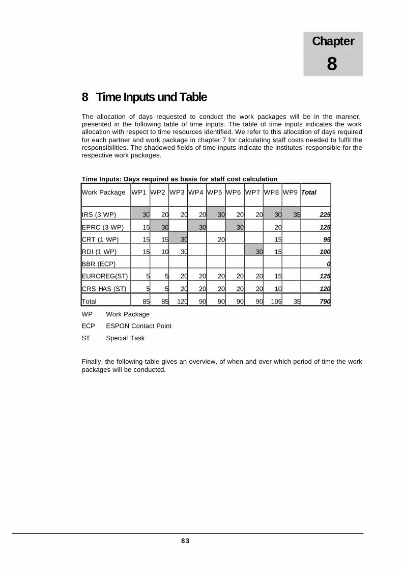
83
8 Time Inputs und Table The allocation of days requested to conduct the work packages will be in the manner, presented in the following table of time inputs. The table of time inputs indicates the work allocation with respect to time resources identified. We refer to this allocation of days required for each partner and work package in chapter 7 for calculating staff costs needed to fulfil the responsibilities. The shadowed fields of time inputs indicate the institutes’ responsible for the respective work packages.
Time Inputs: Days required as basis for staff cost calculation
Work Package WP1 WP2 WP3 WP4 WP5 WP6 WP7 WP8 WP9 Total
IRS (3 WP) 30 20 20 20 30 20 20 30 35 225
EPRC (3 WP) 15 30 30 30 20 125
CRT (1 WP) 15 15 30 20 15 95
RDI (1 WP) 15 10 30 30 15 100
BBR (ECP) 0
EUROREG(ST) 5 5 20 20 20 20 20 15 125
CRS HAS (ST) 5 5 20 20 20 20 20 10 120
Total 85 85 120 90 90 90 90 105 35 790
WP Work Package
ECP ESPON Contact Point
ST Special Task
Finally, the following table gives an overview, of when and over which period of time the work packages will be conducted.
Chapter
8
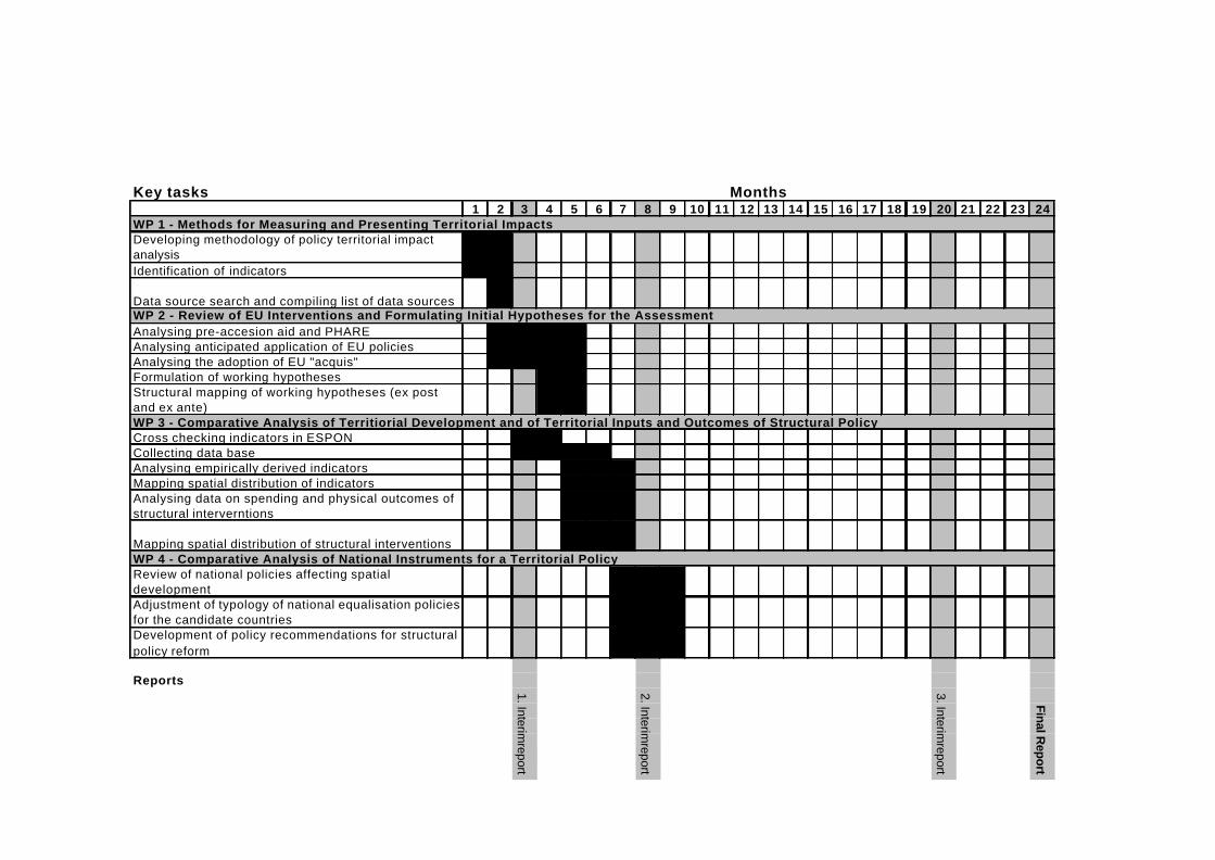
Key tasks1 2 3 4 5 6 7 8 9 10 11 12 13 14 15 16 17 18 19 20 21 22 23 24
Developing methodology of policy territorial impact analysisIdentification of indicators
Data source search and compiling list of data sources
Analysing pre-accesion aid and PHAREAnalysing anticipated application of EU policies Analysing the adoption of EU "acquis"Formulation of working hypothesesStructural mapping of working hypotheses (ex post and ex ante)
Cross checking indicators in ESPONCollecting data baseAnalysing empirically derived indicatorsMapping spatial distribution of indicatorsAnalysing data on spending and physical outcomes of structural interverntions
Mapping spatial distribution of structural interventions
Review of national policies affecting spatial developmentAdjustment of typology of national equalisation policies for the candidate countriesDevelopment of policy recommendations for structural policy reform
Reports
Months
WP 1 - Methods for Measuring and Presenting Territorial Impacts
WP 2 - Review of EU Interventions and Formulating Initial Hypotheses for the Assessment
WP 3 - Comparative Analysis of Territiorial Development and of Territorial Inputs and Outcomes of Structural Policy
WP 4 - Comparative Analysis of National Instruments for a Territorial Policy
1. Interimreport
2. Interimreport
3. Interimreport
Final Report

Key tasks1 2 3 4 5 6 7 8 9 10 11 12 13 14 15 16 17 18 19 20 21 22 23 24
Relating results of maps of WP 2 and WP 3 for identification of differing spatial outcomesTime series and regression analyses for consideration of relations between indicators and spatial developmentSelected case studies of regions with differing spatial development
Analysis of structural pre-accession aid for future EU territoryDeriving first policy recommendations for Structural Fund and pre-accession aid reforms with respect to the candidate countries
Analysis of the relevance of structural pre-accession aid and local factors for the emergence of trans-national macro-regionsAnalysis of cross-border co-operation Selected case studies on cross-border co-operationDeveloping proposals for improved cross-border and trans-national co-operation
Developing policy recommendationsDeveloping propsals concerning institutional settings and instruments for structural programmes
Overall co-ordinationInteraction with other ESPON projectsPresentation of the output
Reports
WP 5 - Ex Post Analysis of the Influence of Structural Pre-Accession Aid on Balanced Territorial Development in the Candidate C.
Months
WP 9 - Overall Co-ordination, Interactions with other ESPON Projects and Presentation of the Output
WP 6- Ex Ante Analysis of the Influence of Structural Pre-Accession Aid and the Structural Funds on Balanced Territorial Development in the Future EU Territory
WP 7 - Interreg Initiative's Impact on Spatial Integration in Terms of Macro-Regions and Cross-Border Co-operation
WP 8- Development of Policy Recommendations
1. Interimreport
2. Interimreport
3. Interimreport
Final Report