terra incognita tierra adentro shifting allegiances age...
TRANSCRIPT
Edit Root Piles Master Markers Browse Media Users
Maps Biblio Signed in as AtlasYour Account | Sign Out
Atlas Terra Incognita Vincenzo Maria Coronelli: America Settentrionale... 1688 CoronelliRioAbajo
1562 1570 1602 1650 1688
Terra Incognita
1745 1758 1771 1779
Tierra Adentro
1810 1818 1823 1844 1846 1851
Shifting Allegiances
1857 1867 1892 1897 1925
Age of Technology
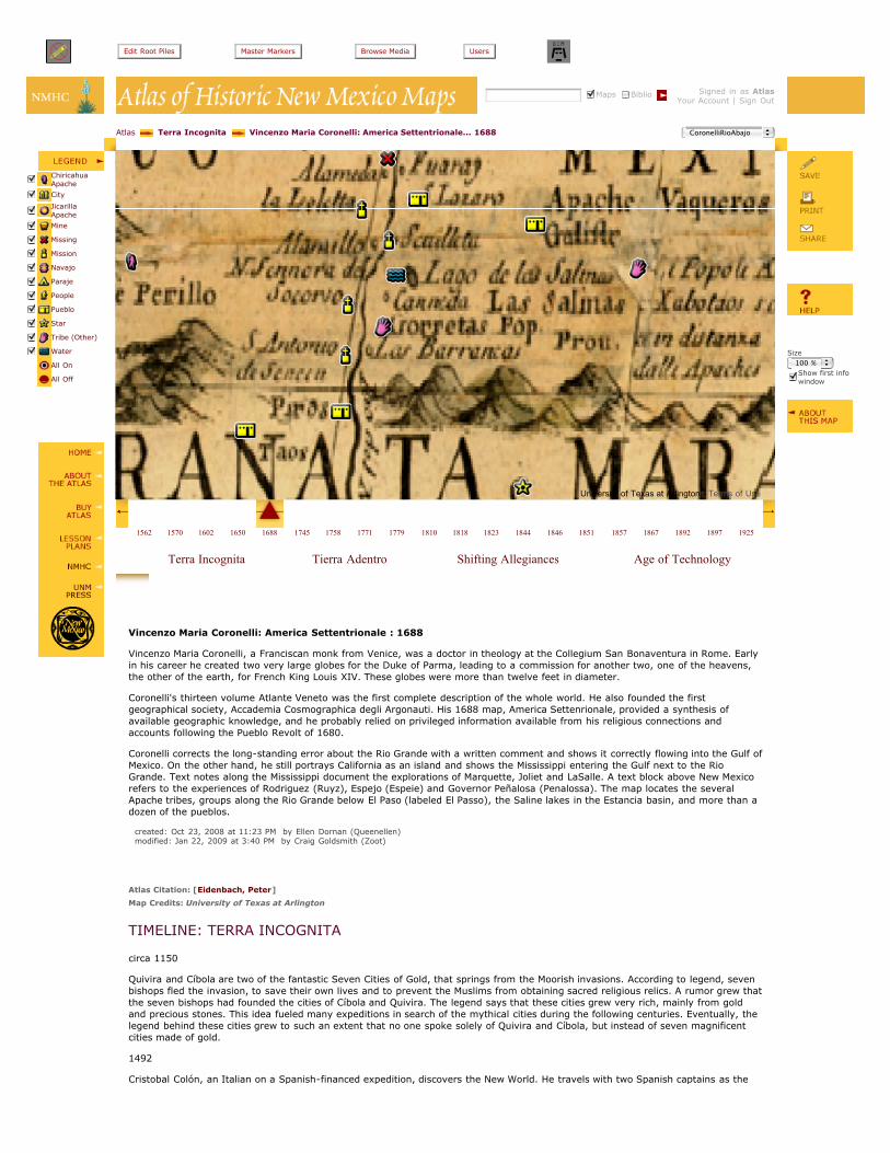
Vincenzo Maria Coronelli: America Settentrionale : 1688
Vincenzo Maria Coronelli, a Franciscan monk from Venice, was a doctor in theology at the Collegium San Bonaventura in Rome. Earlyin his career he created two very large globes for the Duke of Parma, leading to a commission for another two, one of the heavens,the other of the earth, for French King Louis XIV. These globes were more than twelve feet in diameter.
Coronelli's thirteen volume Atlante Veneto was the first complete description of the whole world. He also founded the firstgeographical society, Accademia Cosmographica degli Argonauti. His 1688 map, America Settenrionale, provided a synthesis ofavailable geographic knowledge, and he probably relied on privileged information available from his religious connections andaccounts following the Pueblo Revolt of 1680.
Coronelli corrects the long-standing error about the Rio Grande with a written comment and shows it correctly flowing into the Gulf ofMexico. On the other hand, he still portrays California as an island and shows the Mississippi entering the Gulf next to the RioGrande. Text notes along the Mississippi document the explorations of Marquette, Joliet and LaSalle. A text block above New Mexicorefers to the experiences of Rodriguez (Ruyz), Espejo (Espeie) and Governor Peñalosa (Penalossa). The map locates the severalApache tribes, groups along the Rio Grande below El Paso (labeled El Passo), the Saline lakes in the Estancia basin, and more than adozen of the pueblos.
created: Oct 23, 2008 at 11:23 PM by Ellen Dornan (Queenellen) modified: Jan 22, 2009 at 3:40 PM by Craig Goldsmith (Zoot)
Atlas Citation: [Eidenbach, Peter]
Map Credits: University of Texas at Arlington
TIMELINE: TERRA INCOGNITA
circa 1150
Quivira and Cíbola are two of the fantastic Seven Cities of Gold, that springs from the Moorish invasions. According to legend, sevenbishops fled the invasion, to save their own lives and to prevent the Muslims from obtaining sacred religious relics. A rumor grew thatthe seven bishops had founded the cities of Cíbola and Quivira. The legend says that these cities grew very rich, mainly from goldand precious stones. This idea fueled many expeditions in search of the mythical cities during the following centuries. Eventually, thelegend behind these cities grew to such an extent that no one spoke solely of Quivira and Cíbola, but instead of seven magnificentcities made of gold.
1492
Cristobal Colón, an Italian on a Spanish-financed expedition, discovers the New World. He travels with two Spanish captains as the
Size100 %Show first infowindow
ChiricahuaApache
City
JicarillaApache
Mine
Missing
Mission
Navajo
Paraje
People
Pueblo
Star
Tribe (Other)
Water
All On
All Off
University of Texas at Arlington - Terms of Use

captains of the Niña and the Pinta. Martin Alonzo Pinzon sailed as captain of the Pinta, but he was also the co-owner of the Niña andthe Pinta. His brother, Vincente Yáñez Pinzon, sailed as captain of the Niña. Vincente Pinzon made additional explorations in Southand Central America.
1493
Papal Bull dividing all land in the new world between Portugal and Spain.
1499 Vicente Yáñez Pinzón, Alonso de Ojeda, Americo Vespucci, Juan de la Cosa, Alonso Niño and Cristóbal Guerra were sent by KingFerdinand and Queen Isabella to explore new territories. They went along the coast of Brazil to the Gulf of Mexico and the Floridacoast. They also reached the Chesapeake Bay.
1500
Juan de la Cosa drew the first map of America's coastline.
1513
Juan Ponce de Leon, in search of the fountain of youth and other fabulous riches, instead became the first European to land inFlorida. At the time, he was also the first governor of Puerto Rico. On a later expedition, he discovered the Gulf Stream. This currentbecame very important for Spanish trips from Europe to the Americas.
1519
Captain Alonso Alvarez de Pineda explored and charted the Gulf Coast from Florida to Mexico. De Pineda and his crew were the firstEuropeans in Texas, and claimed it for Spain.
1528
Panfilo de Narvaez led a disastrous expedition to settle Florida, when almost all of his men, and de Narvaez himself, died after beingabandoned onshore. Four men survived, and spent the next eight years crossing Texas, New Mexico, and Arizona, looking for aSpanish settlement. Cabeza de Vaca and his three companions were the first Europeans to explore the Southwest, enter New Mexico,and contact many Southwestern tribes.
1528-1536
Alvar Cabeza de Vaca explores Texas, Arizona and New Mexico. De Vaca published an account of his journey upon his return to NewSpain. He receives a copper bell on the Rio Grande & is told that inhabitants farther north on the river "there were many plates ofthis same metal buried in the ground in the place where it had come and that it was a thing which they esteemed highly and thatthere were fixed habitations where it came from." Buckingham Smith's translation of Cabeza de Vaca's relacion.
1539
Fray Marcos de Niza, a Franciscan priest, claimed to have traveled to the fabled "Seven Golden Cities of Cibola" during the summerof 1539. The Viceroy of New Spain sent Fray Marcos to accompany Estevan, a Moorish slave who had traveled with Cabeza de Vaca,to find the great cities in the north the desert tribes had described. Estevan was killed at Zuni Pueblo, but Fray Marcos returned toMexico to report that indeed, great cities lay to the north.
1540-1542
Francisco Vasquez de Coronado searched for the Seven Golden Cities of Cibola for nearly three years, covering huge areas ofArizona, New Mexico, the Grand Canyon, the Texas panhandle, Kansas, and Colorado. In Tiguex, and then at Cicuye, he came intoconflict with the pueblos, and subsequent expeditions have to contend with the negative results of Coronado's decisions.
1540
Alernando de Alarcon takes boats from Aculpulco to the Colorado River, and ascends the river twice to determine if California is anisland. Far upriver (before the canyons begin) he meets a man familiar with the pueblos and with the plains tribes. Their informanttells them of Coronado's doings.
1542
Juan Rodriguez Cabrillo sailed from Acapulco to southern California, claiming California for King Charles I of Spain. Cabrillo namedSan Diego Bay and Santa Barbara.
1548
Zacatecas founded.
1562
Diego Gutiérrez published a map where California appeared for the first time.
1563
Durango founded.
1563-1565
Francisco de Ibarra explored New Mexico.
1565
Captain Pedro Menendez de Aviles established a settlement at St. Augustine, Florida, making it the oldest European city in the U.S..De Aviles also explored the coastline of North America as far north as St. Helena Island, South Carolina, and had forts built along thecoast for protection.
1565-1580
Mines open in Santa Barbara, San Bartolome, Parral. The rich mines of northern Mexico drove demand for both workers and food,both of which New Mexico supplied for centuries.
1573
Council of the Indies Code is established for regulating new domains. New laws require:
- discoveries were to be made with "Peace and Mercy"
- no injuring native peoples
- only the King or his representative can authorize expeditions
- Spanish governments can't aid one tribe over another
1581
Francisco Sanchez Chamuscado and Fray Agustin Rodriguez enter the pueblo province, which they call San Felipe, leading 9 spanishmen and 16 indian servants. They leave 2 priests behind: Juan de Santa Maria gets killed by the Maguas Indians; Fray FranciscoLópez is killed in Puaray (near Bernalillo).
1582-1583
Don Antonio Espejo launches an expedition to rescue the priests, and upon finding that there were no priests left alive to rescue,traveled around New Mexico, from the Galisteo Basin to Jemez, claiming New Mexico for the King.
1589
Luis de Carabajal governor of Nuevo León, gets arrested by the Inquisition, and his Lieutenant Governor, Castaño de Sosa, takes hisseat.
1590-1591
Governor de Sosa takes the entire colony on an unauthorized expedition of New Mexico. Troops are sent from Saltillo to arrest deSosa, who is exiled to the Philippines.
1594-1596
Antonio Gutiérrez de Humaña and Francisco Leyva de Bonilla explore New Mexico and Colorado as far as the Purgatoire River in anunauthorized expedition. While in present-day Kansas, Humaña murdered Bonilla, then all men were killed before they could leavethe plans.
1596
Juan de Zaldivar explored the San Luis Valley of Colorado.
1598-1608
Don Juan de Oñate brought the first colony to New Mexico, and explored vast areas of New Mexico, Colorado, and Kansas. Hereached the South Sea in 1605, and signed his name at on Inscription Rock, now El Morro National Monument. Farfán exploresArizona on behalf of Oñate and reports the discovery of large pearls and lodes of rich ore.
1598
Juan de Archuleta explored Colorado as far as Kiowa County.
1602
Sebastián Vizcaíno sailed up the coast of California, and named Monterey Bay, San Diego, San Clemente, Catalina, Santa Barbara,Point Concepcion, Carmel, Monterey, La Paz, and Ano Nuevo. Vizcaíno also tried unsuccessfully to colonize southern California.
1607
First permanent British colony founded by Capt. John Smith at Jamestown, VA.
1610
In Santa Fe, New Mexico, the Spanish built the block long adobe Palace of the Governors.
1630, 1640
Fray Alonso Benavides makes an inspection of the New Mexico missions and the progress in converting the pueblos. He reportsseveral wonders, including the conversion of the Xumanas through the miraculous apparition of Mother Luisa de Carrion.
1641-late 1650s
Smallpox epidemic devastates New Mexico.
1653
Captain Alonso de Leon followed Rio de Palmas (Rio Grande) a few hundred miles to the mouth and reported prospering Indianfarmers.
1660-1662
Drought in New Mexico; war parties of nomadic tribes strike Cerralvo, Saltillo, Monterey, Casas Grandes, and Chihuahua.
1661- 1662
Don Diego Peñalosa becomes governor of New Mexico. Don Diego Peñalosa, accused of seditious and scandalous behavior by theInquisition, gets exiled from Spain and her dominions. Twenty years later, he manages to get the ear of the French monarch, arguingfor an attack from Louisiana and seize northern Mexico. This plan may have encouraged Sieur La Salle to make an expedition to themouth of the Rio Bravo in "Florida" with an eye to founding a French colony. Their plans come to nothing, but Coronelli's 1688 mapwas inspired in large part by this saga.
1668
Widespread hunger in New Mexico.
1671
Disease, Apache raids.
1675
Senecu destroyed by Apache attack, never resettled .
1673
Fray Juan Larios recruits a reconnaissance team to meet and convert tribes along the Rio Grande, south to La Junta del Rios, where
the Pecos and the Rio Grande meet. Lieutenant Fernando del Bosque led the expedition, made notes of the country and its products,and recommended three settlements along the river, a recommendation which Spain would continue to ignore for a long time.
1680
Tired of harsh treatment and religious intolerance, the Pueblo people band together under the leadership of a man named Popé anddrive the Spanish from the New Mexico colonies. The rebels destroy and deface most of the Spanish churches. The Spanish retreat tothe south side of the Rio Grande, and found the city El Paso while waiting eleven years for reinforcements.
1682
Robert Cavalier, Sieur de la Salle commissioned to conquer Spain's northern American colonies in 1682, France claims Louisiana fromRio de las Palmas (modern-day Rio Grande) up the Gulf Coast.
1683
Governor Otermin's replacement is General Domingo Jironza Petriz de Cruzate. Cruzate extends the reach of El Paso south and eastalong the Rio Grande, and responds to requests for missionaries from tribes from the area of Junta de los Rios.
1691-1695
Francisco de Vargas reconquered New Mexico and entered the San Luis Valley.
1687-1711
Father Eusebio Francisco Kino, a Jesuit priest, founded many missions and explored areas the Pimería Alta region of New Spain,including what are now northern Mexico, California, and Arizona. He founded his first mission in what is now Sonora, Mexico, thenspent 25 years exploring and mapping the lands along the Rio Grande, the Colorado River, and the Gila River, traveling as far as theheadwaters for the Rio Grande and the Gila.
1706
Juan de Ulibarri crossed Colorado as far as the Arkansas Valley into Kiowa County.
created: Jan 27, 2009 at 10:04 PM by Ellen Dornan (Queenellen) modified: Jul 1, 2009 at 10:06 AM by NMHC Atlas (Atlas)
Atlas | About the Atlas | Help | Lesson Plans | Bibliography | NMHC | UNM Press | Contact/Comments | Buy Atlas | Student Maps
Website and Contents Copyright ©2008 - 2009 New Mexico Humanities Council. All rights reserved.
produced by: Queenellen Enterprises
design/programming by: 1uffakind.com
managed by: NMHC