tennessee roadway information system - … safety data program tennessee roadway information system...
TRANSCRIPT
Roadway Safety Data Program
TENNESSEE ROADWAY INFORMATION SYSTEM
STATE AND LOCAL DATA INTEGRATION
CASE STUDY FHWA-SA-14-038
Prepared for
Federal Highway Administration Office of Safety
Roadway Safety Data Program http://safety.fhwa.dot.gov/rsdp/
June 6, 2014

(Page intentionally left blank.)

TENNESSEE ROADWAY INFORMATION SYSTEM
i
Notice
This document is disseminated under the sponsorship of the U.S. Department of Transportation in the interest of information exchange. The U.S. Government assumes no liability for the use of the information contained in this document.
The U.S. Government does not endorse products or manufacturers. Trademarks or manufacturers’ names appear in this report only because they are considered essential to the objective of the document.
Quality Assurance Statement
The Federal Highway Administration (FHWA) provides high-quality information to serve Government, industry, and the public in a manner that promotes public understanding. Standards and policies are used to ensure and maximize the quality, objectivity, utility, and integrity of its information. FHWA periodically reviews quality issues and adjusts its programs and processes to ensure continuous quality improvement.

TENNESSEE ROADWAY INFORMATION SYSTEM
ii
ACKNOWLEDGEMENTS
The Roadway Safety Data Program team would like to thank the following individuals who graciously provided information needed to develop this case study.
Name Title Department Email/Phone#
Brian Hurst Safety Manager TDOT [email protected]
615.253.2433
Jeff Murphy Information Systems Manager
TDOT [email protected]
615.741.3421
Bryan Semore Information Resource Specialist
TDOT [email protected]
Tom Eldridge Software Consultant TDOT
(Intergraph)
615.417.9643

TENNESSEE ROADWAY INFORMATION SYSTEM
iii
TABLE OF CONTENTS
INTRODUCTION ......................................................................................................... 1
BACKGROUND ............................................................................................................ 1
SYSTEM DESCRIPTION AND USE ........................................................................... 2
DATA INTEGRATION ................................................................................................ 4
DATA MANAGEMENT PRACTICES ........................................................................ 5
RESOURCES.................................................................................................................. 6
KEY OUTCOMES AND LESSONS LEARNED ......................................................... 6
SUMMARY ..................................................................................................................... 7
SOURCES ...................................................................................................................... 8
TABLE OF FIGURES
Figure 1 eTRIMS Start Screen: A photo depicting how the application looks upon start-up. The side panel on the right will retract to allow viewing of the entire map area. ..................................................................................................................................... 3
Figure 2 eTRIMS Queries: A photo showing two queries mapped 1) Davidson County State Routes 2) Davidson County Interstates .................................................. 4

TENNESSEE ROADWAY INFORMATION SYSTEM
iv
ACRONYMS AADT Annual average daily traffic AASHTO American Association of State Highway and Transportation Officials DOT Department of Transportation FDE Fundamental Data Elements FHWA Federal Highway Administration GIS Geographic information system GPS Global positioning system HPMS Highway Performance Monitoring System HSIP Highway Safety Improvement Program HSIS Highway Safety Information System HSM Highway Safety Manual LIDAR Light detection and ranging MAP-21 Moving Ahead for Progress in the 21st Century MIRE Model Inventory of Roadway Elements MIS Management Information System NCHRP National Cooperative Highway Research Program NHS National Highway System OIT Office of Information Technology RSDP Roadway Safety Data Program TMS Traffic Monitoring System XML Extensive Markup Language

TENNESSEE ROADWAY INFORMATION SYSTEM
v
EXECUTIVE SUMMARY
Quality data are the foundation for making important decisions regarding the design, operation, and safety of roadways. While crash data have been a consistent element of highway safety analysis, in recent years there has been an increased focus on the combination of crash, roadway and traffic data to make more precise and prioritized safety decisions. The application of advanced highway safety analysis processes and tools requires a comprehensive inventory of roadway safety data combined with crash data to better identify and understand problems, prioritize locations for treatment, apply appropriate countermeasures, and evaluate the effectiveness of the those countermeasures. Comprehensive roadway safety data include information on roadway and roadside features, traffic operations, traffic volumes, and crashes.

(Page intentionally left blank.)

TENNESSEE ROADWAY INFORMATION SYSTEM
1
INTRODUCTION
This case study outlines a centralized, State-led data collection effort for safety data and analysis. The Tennessee Roadway Information Management System (TRIMS) is a single integrated system that includes State and local roadways, structures, pavement, traffic, photo logs, and crash data. Roadway inventory and crash data for all public roads are included. The Tennessee Department of Transportation (TDOT) implemented TRIMS as a mainframe database in 1972 and moved to a client server Oracle database in 1996. TDOT has had a great track record of success with TRIMS achieved by developing a tool that the State DOT and local agencies (as well as contractors) could all use. The local roadway data collection effort (conducted as a 5-year project that began in 2007) resulted in a product that includes the same information on local roads as is collected for State roads.
BACKGROUND
Tennessee has 95,523 miles of public roads of which 13,884 miles are State-maintained roadways and 81,639 miles are local-maintained roadways. Of the roads classified as local functional class: 57,950 are county; 22,159 are city; 1,186 are Federal; and 344 are State Park. Historically, the local agencies within Tennessee collected little (if any) data on their roadways but did share the data with the State. TDOT included some of the local roadway information in their database but the local data could not be included in the Linear Referencing Systems (LRS) spatial network used by TRIMS because they did not have the correct geometry to link the data to the local roads.
To address this issue, TDOT initiated the effort to update existing local road inventory and collect Global Positioning System (GPS) centerlines to complete the LRS spatial network used by the TRIMS database. The goal was to create an inventory for all local roads. The LRS spatial network is used for accurate mapping and reporting of the Highway Performance Monitoring System (HPMS) data, crash data, bridge data, and asset management. The State hired a contractor to collect the data in order to maintain rigorous data collection standards and to ensure quality data.
The data collection process required only little involvement from the local agencies. Each county provided the 911 road name list. At the end of the project, TDOT provided the roadway data to the local agencies to certify on the final map for their jurisdiction.

TENNESSEE ROADWAY INFORMATION SYSTEM
2
At the end of the 5-year project, the software that was used by the contractor to do the initial data collection was turned over to TDOT so they are able to continue/add to the effort as needed.
Overall, the contractor collected 67,500 miles of local road inventory and GPS centerline which added to the existing 30,000 miles of Interstate, State Highway, and functional route roadway inventory and GPS centerline data.
SYSTEM DESCRIPTION AND USE
As of the date of this case study, TRIMS is comprised of two related systems with the following characteristics and capabilities:
• TRIMS – Tennessee Roadway Information Management System
o Developed as a mainframe database in 1972 and moved to client server Oracle database in 1996.
o Client/server application is a LRS database (in Oracle, original LRS established in 1970s) that contains roadway inventory, structures, pavement, photolog, traffic, and crash data.
o Data-centric. o Software package available to TDOT, local agencies, and contractors.
• eTRIMS – Web-based version of TRIMS
o Development of the application began in 2007. o Web-based application of TRIMS (no software package needed for 90% of users). o Map-centric. o Able to identify any specific assets through the query tool. o Goal is to replace TRIMS. o Available to TDOT, local agencies, and contractors at no cost.
TENNESSEE ROADWAY INFORMATION SYSTEM
3
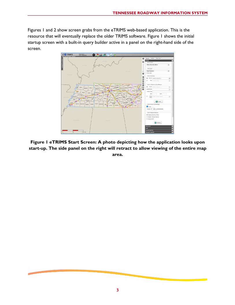
Figures 1 and 2 show screen grabs from the eTRIMS web-based application. This is the resource that will eventually replace the older TRIMS software. Figure 1 shows the initial startup screen with a built-in query builder active in a panel on the right-hand side of the screen.
Figure 1 eTRIMS Start Screen: A photo depicting how the application looks upon start-up. The side panel on the right will retract to allow viewing of the entire map
area.

TENNESSEE ROADWAY INFORMATION SYSTEM
4
Figure 2 shows joint mapping of two query results. In this display, Interstates in Davidson Country are shown in blue and State routes within the county are show in red.
Figure 2 eTRIMS Queries: A photo showing two queries mapped 1) Davidson County State Routes 2) Davidson County Interstates
DATA INTEGRATION
TDOT hired a contractor who collected data on linear reference points, lane widths, shoulder widths, intersections, and speed limits. Data were collected using an instrumented vehicle and the data were submitted electronically from the contractor and put through rigorous checks to ensure that it was as clean as possible. The data collection effort required a big commitment from TDOT to fund and staff the program but the managers felt it was important and were vested in the program. As a result, TDOT has collected all of the Model Inventory of Roadway Elements (MIRE) Fundamental Roadway and Traffic Data Elements with the exception of Average Annual Daily Traffic on some local roads. The database structure includes these data elements but they are not collected for all local roads.
The first data submission was a tab-delimited file from the GPS collection. TDOT mapping personnel imported the file into a temporary geometry database and created the geometry

TENNESSEE ROADWAY INFORMATION SYSTEM
5
(turned the points into lines) to make a working set of graphics (lines). A second submittal was a text file with the data elements according to log mile.
When the contractor in the field identified a new route, they would assign a route number and log mile system. The contractor eventually developed a master list of road names. Any features that were not linearly referenced in the data were sent back to the contractor for verification.
DATA MANAGEMENT PRACTICES
The Transportation Research Board’s NCHRP Report 666: Target-Setting Methods and Data Management to Support Performance-Based Resource Allocation by Transportation Agencies defined the concepts of data management, data governance, and data stewardship. Briefly, Data Management is the set of practices related to collecting, storing, and preparing data for use (e.g., in safety decisionmaking). Data Governance is the set of standards and practices applied to any data resource to control the quality of the data. Data Stewardship refers to ownership responsibility and control over data including authority for its collection, storage, integration, and use. Regarding data management, TDOT performed external checks with the local agencies and utilized an internal 32-step workflow for the entire process. When inventory for a county was complete, TDOT created a map directly from the data as a last step in the process. A TDOT staff member then took the map to each county and/or city and had the local staff sign off on the map as part of an in-person meeting. The local agencies had the opportunity to provide corrections to the data (if needed) and were required to sign off on the map indicating it was an accurate depiction of their roads. Some counties signed off immediately; some kept the map for several days to pore through it. TDOT also tracked the date on which the county approved the map. This process took several months and was completed for all 380 cities and all 95 counties.
TDOT has authority over TRIMS with input from the local agencies. TRIMS has no formal data governance program or practice; however, TDOT does focus on data quality, supporting their business process, and ensuring that the data is easily accessible to the TDOT organization as well as their partners (other local and State organizations, consultants, and contractors).
TRIMS is owned and maintained by TDOT. eTRIMS is a web application that is map-centric (as opposed to TRIMS which is data-centric) and a read-only version is available to TDOT, local agencies, and contractors. Currently TRIMS/eTRIMS requires a manager, a supervisor, and 6-7 people working on “TRIMS support” (i.e., updates, software installation, fixing inaccuracies, etc.). Overall, 25-30 people maintain the program (i.e., graphic maintaining, website maintaining, data collecting, etc.) throughout the State.

TENNESSEE ROADWAY INFORMATION SYSTEM
6
RESOURCES
Funding for TRIMS and eTRIMS development plus the local roadway data collection effort came from State Planning and Research Funds (SP&R). The effort to justify the use of the SP&R funds (close to $11.5 million) took well over a year.
Sources of funding to maintain the effort in the future are unknown. However, improving crash data collection and analysis is an emphasis area in the Tennessee Strategic Highway Safety Plan. Therefore, Highway Safety Improvement Program Funds (HSIP) may be used.
KEY OUTCOMES AND LESSONS LEARNED
TRIMS/eTRIMS deliver the following key outcomes and products for local agencies and TDOT:
• There has been good support from management authorizing time and funding for data quality checks.
• TDOT’s Project Safety Office now serves as the reporting arm of TDOT to FHWA.
• TRIMS supports the State’s federal data reporting.
• TRIMS enables TDOT to be the first State to submit HPMS data each year.
• Due to solid LRS and TRIMS, TDOT is in the top 10 nationwide for data quality.
• All outside contractors typically request TRIMS data before starting work/projects.
• Saves TDOT a lot of time through the ability to supply contractors with eTRIMS data (contractors can create a shapefile and download it, eTRIMS has been custom designed for these types of applications). Note – the next iteration of eTRIMS will also export KML files.
• TRIMS feeds the system that generates data for the Highway Safety Improvement Program (HSIP) report analyses.
• Every system at TDOT utilizes TRIMS for locating features, elements, etc.
• TRIMS allows TDOT to more easily conduct safety analyses in specific focus areas: e.g., run-off-road (ROR) crashes, pedestrians/bicyclists.
The lessons learned from the TRIMS/eTRIMS effort include the realization that the instrumented van collecting data in real time is superior to their prior method of collecting photos and performing post-processing. In addition, TDOT found it was necessary to be as

TENNESSEE ROADWAY INFORMATION SYSTEM
7
specific as possible with the contractor in order to ensure data quality and that the data met TDOT’s existing standards. TDOT also found that some local/State intersection points needed to be adjusted as a result of the new local data collection effort. Other States should be prepared to update their State system (particularly if the data may be out of date). Finally, TDOT made improvements to the data collection effort throughout the 5-year process in order to ensure the highest possible accuracy. The use of eTRIMS, a map-centric system, made errors in the data much more obvious.
SUMMARY
This case study presents a State-managed program developed in Tennessee to integrate the local road system into the TDOT database by completing the centerline inventory to incorporate into the statewide network. This effort greatly improved the capability of TDOT to accurately and more quickly locate crashes, improve overall data accuracy, allow TDOT to look at all assets of roadway information in one place, and facilitate safety analyses for a variety of different purposes. TRIMS’ success is due to having a solid LRS that had been in place for many decades. The LRS applies much of the additional data so TDOT did not have to merge different LRS as has been necessary in other States. Use of a modern, web-based and map-centered tool (eTRIMS) has improved accessibility and the ability of State and local users to identify and correct errors.

TENNESSEE ROADWAY INFORMATION SYSTEM
8
SOURCES
This case study was compiled with the use of the following sources:
• Phone and email conversations with Tennessee DOT staff.
• NCHRP Synthesis 458: Roadway Safety Data Interoperability between Local and State Agencies, http://onlinepubs.trb.org/onlinepubs/nchrp/nchrp_syn_458.pdf.
• Webcast on FHWA’s GIS website that includes a live demo of eTRIMS:
o http://www.gis.fhwa.dot.gov/webcast20_tn.asp
• NCHRP Report 666: Target-Setting Methods and Data Management to Support Performance-Based Resource Allocation by Transportation Agencies (Section I: Chapter 4, page I-58), http://onlinepubs.trb.org/onlinepubs/nchrp/nchrp_rpt_666.pdf.
This project was performed by Robert Scopatz, Yuying Zhou, and Angela Wojtowicz from Vanasse Hangen Brustlin, Inc.; and Daniel Carter, Sarah Smith, and Patricia Harrison of the University of North Carolina, Highway Safety Research Center.
FHWA, Office of Safety Stuart Thompson. P.E. Federal Highway Administration 202-366-8090 [email protected]

(Page intentionally left blank.)

FHWA-SA-14-038