template camx ancillary input development chris emery environ international corporation, novato ca...
TRANSCRIPT

TemplateTemplate
CAMx Ancillary Input Development
Chris EmeryENVIRON International Corporation, Novato CA
November 14, 2012

2
Meteorological Processing
• WRFCAMx v3.3 converts raw WRF output to CAMx formats– Time-shift from UTC to CST– Extract 27 vertical layers up to 11 km MSL– Use every WRF layer up to 3 km, collapse layers above– Diagnose sub-grid clouds in 36 & 12 km grids (not 4 km)– Calculate vertical turbulent exchange coefficients (or
“diffusivities”, Kv)• KVPATCH used to enhance Kv in specific cases
– Enhance minimum nighttime Kv in urban surface layer– Extend diffusion through clouds that cap the daytime
boundary layer

3
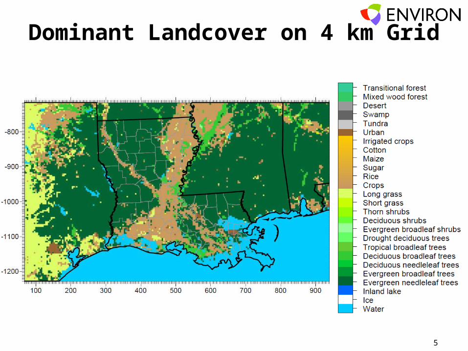
Development of Landuse/Landcover
• Defines surface types for dry deposition calculations– Prepared for the 36/12/4km grids
• Gridded time-invariant fields for– Landuse – 26 categories for Zhang dry deposition
scheme– Leaf area index (LAI)
• 2000 North America Land Cover (NALC) database– Satellite derived data at 1 km resolution http://
edc2.usgs.gov/glcc/nadoc2_0.php– 29 categories cross referenced to 26 CAMx categories

4
Development of Landuse/Landcover
• LAI MEGAN biogenic model– Global 30 second (~1 km) resolution– 2001 monthly averages http://acd.ucar.edu/~
guenther/MEGAN/MEGAN.htm
5
Dominant Landcover on 4 km Grid
6
Column Albedo/Haze/Ozone
• This file defines state of atmosphere for photolysis rate calculations
• AHOMAP generates gridded CAMx input file containing– Surface albedo (from landuse file)– Total atmospheric column haze opacity (default, constant)– Total atmospheric ozone column
• Total Ozone Mapping Spectrometer (TOMS)– Aboard OMI satellite platform in 2010– Daily, 1 degree resolution http://
ozoneaq.gsfc.nasa.gov/OMIOzone.md

7

8
Photolysis Rates
• TUV Version 4.8 (NCAR)– Reads AHO file– Creates lookup table of clear-sky photolysis rates
Dimensions include: solar zenith angle, height above ground, surface albedo, haze column, ozone colum
– Photolysis reactions defined by the Carbon Bond version 6 (CB6) chemical mechanism
• These rates are internally adjusted within CAMx for hourly gridded cloud conditions

9
Initial/Boundary Conditions
• IC’s represent initial concentration pattern from which the simulation starts
• BC’s represent concentration patterns outside of the outer CAMx modeling domain that are transported into the grid system
• Derived from MOZART-4 (NCAR) output for 2010– http://www.acd.ucar.edu/wrf-chem/mozart.shtml– 1.9 by 2.5 degree horizontal resolution, 56 vertical layers– 6-hour output intervals– Horizontally and vertically interpolated to CAMx 36 km grid– Mapped to CB6 chemical speciation– Data were time shifted from UTC to CST

10
CAMx Configuration
• Chemistry– CB6 ozone only (no PM)– In-line TUV cloud photolysis adjustment– Wet removal (from WRF cloud+rain output)– Zhang dry surface deposition
• Standard advection/diffusion– Sensitivity tests for Kv inputs, ACM2 treatment
• Plume-in-Grid (PiG) for large NOx sources– Sensitivity tests for PiG