tectonic events at the intersection between the hope fault ... · tectonic events at the...
TRANSCRIPT

Tectonic Events at the Intersection
Between the Hope Fault and the
Purcell Trench, Northern Idaho
GEOLOGICAL SURVEY PROFESSIONAL PAPER 719


Tectonic Events at the Intersection
Between the Hope Fault and the
Purcell Trench, Northern IdahoBy JACK E. HARRISON, M. DEAN KLEINKOPF, and JOHN D. OBRADOVICH
GEOLOGICAL SURVEY PROFESSIONAL PAPER 719
The right-lateral Hope Fault was active
intermittently from Precambrian to
Eocene whereas the Purcell Trench is
a Late Cretaceous graben
UNITED STATES GOVERNMENT PRINTING OFFICE, WASHINGTON : 1972

UNITED STATES DEPARTMENT OF THE INTERIOR
ROGERS C. B. MORTON, Secretary
GEOLOGICAL SURVEY
V. E. McKelvey, Director
Library of Congress catalog-card No. 70-189044
For sale by the Superintendent of Documents, U.S. Government Printing OfficeWashington, D.C. 20402 - (paper cover)
Stock Number 2401-2085

CONTENTS
Abstract ________________________Introduction _____________________. General geology _________________
Rock types ___________________Belt Supergroup __________.Purcell sills ______________. Lakeview Limestone ____________Migmatite ________________Quartz monzonite _________Granodiorite _______________Diabase-diorite _____ ____________Sandpoint Conglomerate ___________Granodiorite and dacite porphyries Surficial deposits __________
Structure ________________.
Page 1
1
33345555666
General geology Continued Structure Continued
Folds _________________.Faults _________________-
Isotopic age data _____________Rocks in and near the Purcell Trench Regional correlations ____________.
Geophysical data ________________.Physical properties _ _ . Gravity interpretations ______ ____
Gravity anomalies ________. Magnetic interpretations __________
Magnetic anomalies _________Sequence of tectonic events _______ _.Regional implications _____________-References cited _________________.
Page
810111112131415181819202123
ILLUSTRATIONS
PagePLATE 1. Maps showing the surface and bedrock geology, Bouguer gravity, and
aeromagnetics of the Purcell Trench-Hope fault intersection, northern Idaho _____________________________In pocket
FIGURE 1. Index map showing location of study area with reference to the Pur cell Trench and the Hope fault _____________________ 2
2. Photographs of the Sandpoint Conglomerate _________ 73. Diagrams illustrating possible stresses to form tensional openings
north of the Hope fault ______________________ 84. Photograph of clay model illustrating top view of folds formed in
upper plate of thrust ___________________________ 95. Diagram showing density of rock types in and near the Purcell
Trench ________________________________..___ 166. Diagram showing magnetization of rocks in and near the Purcell
Trench _____________________________________ 177. Map showing principal geologic and tectonic provinces, eastern Wash
ington, northern Idaho, and northwestern Montana __.. 218. Map showing major faults in northern Idaho and northwestern
Montana ____________________________________ 22
TABLES
TABLE 1. Chemical analyses of granodiorite and granodiorite porphyry._.2. Isotopic data on some rocks in and near the Purcell Trench _3. Physical properties of rocks in and near the Purcell Trench __
Page8
1114
in


TECTONIC EVENTS AT THE INTERSECTION BETWEEN THE HOPE FAULT AND THEPURCELL TRENCH, NORTHERN IDAHO
By JACK E. HARRISON, M. DEAN KLEINKOPF, and JOHN D. OBRADOVICH
ABSTRACT
The intersection between the Purcell Trench, a topographic depression extending from Coeur d'Alene Lake northward for about 280 miles, and the Hope fault, a major west-north west-trending right-lateral fault at least 100 miles long, is in the Idaho panhandle. The zone of intercept in the Purcell Trench is largely hidden by glacial debris.
Recent geologic mapping of all bedrock exposures in and near the trench has been used with gravity and aeromagnetic data and potassium-argon age determinations to interpret the tectonic events in the area. The Purcell Trench appears to be a structural feature in the United States that extends for a few miles into Canada where it joins a series of valleys without obvious structural control. The structural part of the trench includes a graben that contains the Upper(?) Cretaceous Sandpoint Conglomerate. The part of the trench in the United States is near the east edge of the Kootenay arc mobile belt, which is a zone of intense deformation and magmatism that began at least as early as the late Pre- cambrian. The present trench is a young feature formed at the time of intrusion of the Kaniksu batholith, about 100 m.y. (million years) ago.
The first break along the Hope fault probobly formed in Belt time. The Hope fault now has an apparent right-lateral offset of 16 miles, of which 3-4 miles are early Tertiary. Subsidiary faults fan out to the northwest from the main Hope fault at its junction with the Purcell Trench. This fault system offsets the Purcell Trench and graben, as well as the Selkirk Mountains that form the west wall of the trench. Some faults in this system contain granodiorite and dacite porphyries that are about 50 m.y. old.
Major intrusive rocks in the area are quartz monzonite and granodiorite, both of the Kaniksu batholith. These rocks are about 100 m.y. old.
The sequence of tectonic and intrusive events in the area in the Precambrian was open folding on north-trending axes, faulting on the Hope fault, intrusion of Purcell sills at least 870 m.y. ago, and block faulting. In the Late Cretaceous the events were intrusion of quartz monzonite of the Kaniksu batholith about 100 m.y. ago accompanied by thrusting from west to east; migmatization and metamorphism of Prichard Formation and Purcell sills to form schists, gneisses, and amphibolite; and cross folding on tight upright to over turned major east-trending and minor north-trending axes. Still later, perhaps 95 m.y. ago, granodiorite of the Kaniksu batholith was emplaced, the trench faults were formed, and the Sandpoint Conglomerate was dumped into the Purcell graben that was forming east of the rising Selkirk Moun tains. Tectonism accompanying the final pulse of intrusion culminated in right-lateral movement on the Hope fault, dur
ing which the north block moved east. This movement re sulted in dilation in and near the trench where granodiorite and dacite porphyries later filled faults. Both the Purcell graben and the Selkirk Mountains were offset 3-4 miles at that time.
INTRODUCTION
Two major structural features, the Hope fault and the Purcell Trench, intersect in northern Idaho (fig. 1). Although the features have been known for about 60 years, the exact nature of each and the relation between them have not been fully under stood, largely because the trench is filled by glacial debris that covers all but a few outcrops. Additional complications have been the uncertainty in the age of higher grade metamorphic rocks thought to be confined to the west wall of the trench and the con sequent uncertainty in the kind and amount of trench faulting necessary to bring these rocks adja cent to low-grade metamorphic rocks on the east wall.
In 1903 Daly (1912) originally identified the topo graphic trench during his survey along the 49th parallel. He (1906, p. 597) named it the Purcell Trench. By "trench" Daly (1906, p. 596) meant "a long, narrow, intermontane depression occupied by two or more streams (whether expanded into lakes or not) alternately draining the depression in oppo site directions." He described the Purcell Trench as extending from Bonners Ferry northward about 200 miles into Canada, through the valleys of Kootenay Lake and the Duncan River to the mouth of the Beaver. He (1912, p. 600) also noted that "the con structional profiles [of the Rocky Mountain and Purcell Trenches] may have been those of grabens * * *." Daly's geologic map (1912, sheet 6) shows pre-Belt rocks faulted against Belt rocks at the Purcell Trench.
Calkins (1909) justified extension of the Purcell Trench south from Bonners Ferry about 80 miles "at least to the southern end of Lake Coeur d'Alene." He also identified and named the Hope fault, which he

HOPE FAULT-PURCELL TRENCH INTERSECTION, IDAHO
116° 115°
--Area of this figure
CANADA__ UNITED I STATES
50I
100 MILES
FIGURE 1. Location of study area with reference to the Purcell Trench and the Hope fault.
recognized as a major fault occupying the Clark Fork valley for about 40 miles of its length southeast from Hope, Idaho, and reported that some evidence of faulting was found in the Purcell Trench. His geologic map shows metamorphic rocks of ques tioned older Precambrian age which are separated from Belt rocks by Coeur d'Alene Lake at the south end of the Purcell Trench.
Schofield (1915, p. 168) argued that the trench owes its present form to modification of a preexist ing valley; Rice (1941, p. 4, map 603A) concurred and showed no fault in the north-northwest-trend ing valley occupied by Kootenay Lake, although he did show several north- to northeast-trending faults in and near the Purcell Trench at the international
boundary. Fyles (1964, 1967) studied part of the Kootenay Lake and Duncan Lake areas in detail. He mapped several faults parallel to and near the valleys that contain the lakes, but he showed no master structure in the valleys. He (1964, p. 9, 10) used the term "Purcell Trench" in only a topo graphic sense.
Kirkham and Ellis (1926, pi. 3, p. 32, 33) identi fied what they called the Kootenai fault in the Purcell Trench. On their geologic cross section the fault is shown as high angle; the text suggests downthrow to the east but also points out that the fault may be an east-dipping thrust. They believed that rocks on both sides of the trench belong to the Prichard Formation, in contrast to the hypothesis

INTRODUCTION
of Daly who believed that the schistose rocks on the west were pre-Belt.
Anderson (1930, pi. 14) made the first geologic map that showed the intersection between the Hope fault and the Purcell Trench. His reconnaissance led him (p. 44) to suggest that a main high-angle trench fault with downthrow on the east connected with the Kootenai fault as mapped to the north by Kirkham and Ellis and, after adjustment for right- lateral offset on the Hope fault, with the Pend Oreille fault mapped by Sampson (1928, pi. 2) as extending up the long north-trending part of Pend Oreille Lake. The question of the presence of older or younger Precambrian rocks on the west wall of the Purcell Trench did not arise because Anderson mapped the Selkirk Mountains, which form the west wall, as granodiorite of Jurassic (?) age. Anderson (1930, p. 19-22) did, however, iden tify, describe, and name the Sandpoint Conglomer ate. This formation is unique to the Purcell Trench, and its origin is critical to the reconstruction of tec tonic events.
Among the more recent mentions of the Hope fault and the Purcell Trench are Pardee's (1950, p. 399) inclusion of the Hope fault as one of the late Cenozoic block faults in western Montana, Griggs' (1964) confirmation of Calkins (1909) observations about the Purcell Trench near Coeur d'Alene Lake, and Savage's (1967) listing of the existing concepts of origin of the Purcell Trench and the Sandpoint Conglomerate. Nevin (1966), working only on the west side of the trench near Bonners Ferry, felt that evidence for a pre-Belt age of the higher metamor- phic grade rock was compelling and that a fault- controlled trench was possible but not essential to explain the structure of the area.
Wheeler's (1966) summary of tectonics in the Western Cordillera of British Columbia does not even mention the Purcell Trench, and yet a com panion paper by Yates, Becraft, Campbell, and Pearson (1966) on tectonics of the same Western Cordilleran province in the United States recognizes it as a significant though somewhat enigmatic struc tural feature that forms the east boundary of the Kootenay arc mobile belt, a broad zone in eastern Washington and southeastern British Columbia in which intrusion, extrusion, and deformation have been intense.
Recent detailed geologic mapping (Harrison and Schmidt, 1971) of the Elmira quadrangle disclosed a series of geologic relations bearing on the tectonic history of the Hope fault and the Purcell Trench.
The narrowest part of the topographic trench is at Elmira, Idaho, where the walls are only 11/2 miles apart; this affords the nearest approach to continu ous outcrop anywhere in the United States part of the trench. All the east side and much of the trench is included in the Elmira quadrangle. All other out crops in the trench south of Elmira and west of the Elmira quadrangle were mapped in detail, and sev eral reconnaissance traverses were extended from the trench for a few miles back into the Selkirk Mountains on the west side. M. D. Kleinkopf pre pared a gravity map of the trench to accompany the geologic map of this report. An aeromagnetic map of part of the area was placed in open file in 1962 (Meuschke and others, 1962), and another map ad joining on the east was published in 1969 (U.S. Geological Survey, 1969). Radiometric dating of some rocks in and near the trench by J. D. Obradovich has further clarified the actual age of certain geologic events. This report uses these new geologic, geophysical, and isotopic age data to help unravel the complex tectonic history at the intersec tion of the Hope fault and the Purcell Trench.
We are particularly grateful for stimulating dis cussions of regional tectonics with our colleagues, S. Warren Hobbs, A. B. Griggs, S. H. B. Clark, and F. K. Miller. D. T. Bishop, Idaho Bureau of Mines and Geology, who is currently preparing a geologic map of Boundary County, gave helpful criticism and provided some unpublished data on faults in his map area. D. L. Peterson provided unpublished gravity data on the Purcell Trench between Pend Oreille and Coeur d'Alene Lakes.
GENERAL GEOLOGYROCK TYPES
Most rock types in the area have been described extensively in other reports. For most rocks dis cussed in this report, only brief descriptions will be given. The interested reader is referred to Anderson (1930) for the petrography of the Sandpoint Con glomerate and of the intrusive rocks in general, to Gillson (1927) for the petrography of the grandior- ite, to Sampson (1928) for descriptions of the Cambrian sedimentary rocks, to Harrison and Jobin (1963) for descriptions of the Belt rocks, and to Savage (1967) for descriptions of the surficial deposits.
Belt Supergroup
Belt rocks of the area are a drab, fine-grained, monotonous sequence at least 42,000 feet thick of argillite, siltite, quartzite, and minor amounts of carbonate rocks. About half of the sequence is the

HOPE FAULT-PURCELL TRENCH INTERSECTION, IDAHO
Prichard Formation, which is the Belt unit exposed most extensively in and near the Purcell Trench (pi. 1). Effects of both regional and contact meta- morphism are evident in Belt rocks. In general, rocks above the middle of the Wallace Formation are in the chlorite-sericite zone of the greenschist facies; below mid-Wallace, rocks of appropriate composition contain increasing amounts of biotite with depth in the stratigraphic section. All Burke and Prichard rocks are well into the biotite zone. Contact metamorphism varies considerably depend ing upon the type of intrusive rock and the degree of deformation accompanying the intrusion. The true effects of the contact metamorphism may be masked by the pervasive regional metamorphism, which is probably related to a metamorphic event about 700- 800 m.y. ago (Reid and Greenwood, 1968, p. 77; Wheeler, 1966, p. 28). Contact metamorphism by Purcell sills prior to the main regional metamor phism is now shown by the formation of hornfels within a few feet of each side of the sill. Contact zones formed after the main regional metamorphism are as much as 2,000 feet wide around Cretaceous granodiorite bodies. At places andalusite has formed in the contact zone. More commonly, the rocks are slightly schistose or gneissic because of formation of biotite and muscovite in crystals larger than usual in the regional biotite zone. Some rocks in the contact zone exhibit abnormal magnetism due to formation of magnetite and pyrrhotite. Forceful intrusion which shoulders aside the wallrocks has formed recumbent folds whose axes are subhorizon- tal and about parallel to the outline of the intruding granodiorite; but little pegmatite, migmatite, or brecciation occurs in the contact zone. The granodi orite commonly is seriate porphyritic at the contact. A second type of contact metamorphism is shown by the Prichard Formation in the northwestern part of the mapped area (pi. 1). In that area the rocks are migmatized through a lit-par-lit injection of alaskite, at places are prograded into the garnet zone and perhaps even into the first phases of the sillimanite zone, and are highly deformed by at least two fold systems.
The Belt Supergroup ranges in age from about 900 m.y. to more than 1,300 m.y. (Obradovich and Peterman, 1968). Lithostratigraphic equivalents of the Belt formations in the mapped area were de posited during two main episodes about 1,100 and 1,300 m.y. ago according to Obradovich and Peter man. The oldest age was determined by rubidium- strontium whole-rock dating of sedimentary rocks near the east edge of the Belt terrane and of meta
morphic biotite in the Prichard Formation near Alberton, Mont. Obviously, the Prichard Formation is older, but its maximum age is limited by the gen eral 1,800-m.y. age of the Precambrian crystalline terrane in nearby parts of western Montana.
The significance of the increasing metamorphic grade of the Prichard Formation from east to west at the north end of the mapped area needs to be emphasized. Exposed in that area is a transition from typical biotitic but bedded rocks of the Prichard Formation into high-grade schists and gneisses identical with those called pre-Belt in many earlier studies partly because they were high-grade metamorphic rocks and partly because the transition had never been observed owing to the glacially cov ered gap represented by the Purcell Trench. A simi lar kind of transition zone on the western flank of the Selkirk Mountains south of Priest Lake has been described by Barnes (1965). Thus, the Selkirk Mountains, cored by granodiorite and quartz mon- zonite, have Prichard Formation on their outer flanks that decreases in metamorphic grade away from the mountain core. The Purcell Trench has apparently interrupted what was a continuous tran sition zone on the eastern flank of the mountains.
Purcell Sills
Sills of Precambrian gabbro to quartz diorite are abundant in the lower part of the Prichard Forma tion (pi. 1). Precambrian sills of similar composi tion have been called Moyie sills, Purcell sills, and the Wishards sill by various authors. The commonly accepted name for them in the area of the report is Purcell sills, but no time or genetic connotation be tween Purcell sills-and Purcell lava is implied.
The sills range in thickness from a few feet to 3,000 feet. Originally the sills consisted of horn blende, calcic plagioclase, and, in minor amounts, quartz, pyroxene, and common accessory minerals. Some of the sills are differentiated. Many sills that are near faults or that were deformed by folding have been altered considerably and now contain abundant biotite, calcite, and epidote. The sills vary in thickness along their strike, but they are persist ent and form good structural markers in folded or highly faulted areas (pi. 1).
In the most highly deformed and metamorphosed areas and in migmatite, the sills are transformed to amphibolite. The transition zone at the north end of the mapped area shows, from east to west, com petent sills that have dragged zones of Prichard biotitic argillite on both sides, then sills bounded by schistose and gneissic Priehard rocks and containing

GENERAL GEOLOGY
small zones of sheared rock (amphibolite) where minor north-trending- fold axes cut the sill, and finally, at and west of the Purcell Trench, highly deformed amphibolite inter layered with schist, gneiss, and migmatite.
Again the significance of these sills and of their metamorphism needs to be emphasized. The abun dance of the sills throughout a several-thousand- foot-thick section of Prichard Formation and their obvious transformation to amphibolite during pro gressive metamorphism virtually obviate all pre vious objections to identifying the high-grade meta- morphic rocks north of the Hope fault and west of the trench with lower grade rocks on the east.
Some further observations about the sills are pertinent to this study. One sill south of the Hope fault (pi. 1) is repeated several times by faults but maintains a constant stratigraphic position. No sill in that stratigraphic position, or higher, occurs on the north side of the Hope fault north of the town of Clark Fork. The thickest sill north of the Hope fault (from which samples 48 and 49 were collected) persists as a thick sill for several miles northward but pinches down rapidly as it cuts southward across the Hope fault scarp and nears the fault. Both these unusual occurrences suggest that the ancestral Hope fault may have been in existence at the time the Purcell sills were emplaced.
Lakeview Limestone
One small area of Lakeview Limestone is shown on the geologic map (pi. 1) on the east side of Pend Oreille Lake and south of the community of Granite. The Lakeview is of Cambrian age. As it is of little consequence in this study, it will not be described or discussed further.
Migmatite
Migmatite is exposed extensively in the north western part of the mapped area (pi. 1). The rock unit consists of schists and gneisses derived from the Prichard Formation, metagabbro and amphibo lite derived from the Purcell sills, and one or both of the related intrusive rocks alaskite and cata- clastic quartz monzonite. Proportions of each rock type range from about 10 percent to about 90 per cent in a given outcrop. The unit grades in general from a high content of leucocratic igneous rock near contacts with quartz monzonite to a low content near contacts with schistose and gneissic Prichard For mation. Contacts themselves are gradational over hundreds of feet and their designations are neces sarily arbitrary.
Migmatite is generally highly deformed, but major
folds can be traced from migmatite continuously into rocks of the Prichard Formation. Migmatite west of Elmira contains moderately abundant layers of amphibolite, but the combination of intense folding and limited outcrop precludes mapping of individual amphibolite layers at the scale of the map.
Quartz Monzonite
The quartz monzonite is a distinctive but some what variable rock consisting of orthoclase, oligo- clase-andesine, quartz, muscovite, and biotite. The quartz monzonite is clearly intruded by granodi- orite. Contacts at many places are sharp, and the granodiorite does not show the cataclasis of the older quartz monzonite.
Several varieties of quartz monzonite, some of which show cataclastic effects, have been mapped and described in detail by Clark (1967), who dis tinguished a quartz monzonite gneiss unit from sev eral varieties in a main mass. The main mass of quartz monzonite is exposed on the hills west of the town of Cocolalla (this report, pi. 1). Clark (1967) suggested that the quartz monzonite gneiss unit at the north end of her mapped area might be a more metamorphosed variety of the quartz monzonite near Cocolalla. Barnes (1965, p. 44-45) also identi fied cataclastic quartz monzonite in his mapping on the west flank of the Selkirk Mountains.
GranodioriteSeveral bodies of granodiorite are so similar in
texture and mineralogy that they can be described together. Most of the granodiorite is a mottled black, white, and pink seriate porphyritic rock consisting principally of potassium feldspar, oligoclase-ande- sine, quartz, and biotite, and, in minor amounts, hornblende locally. The larger phenocrysts common ly are orthoclase and are about half an inch long. Phenocrysts as large as 5 inches long occur in a few places, and at other places medium-grained equi- granular granodiorite forms a part of the exposures. Foliation in most rocks is shown by planar arrange ment of tabular feldspars and, in the finer grained varieties, by planes of biotite crystals. Foliation is parallel to contacts with the enclosing rocks. Very minor amounts of pegmatite are associated with the granodiorite.
Most contacts between granodiorite and other rocks are sharp, and seriate porphyritic granodi orite occurs at places adjacent to the contact. At a few places, narrow broken zones of older rocks are mixed with granodiorite to form a few feet of mig- matic rock that is entirely different from the mig matite mapped as a unit on plate 1. Some zones of contact metamorphism extend outwards from the

6 HOPE FAULT-PURCELL TRENCH INTERSECTION, IDAHO
granodiorite for about 2,000 feet. In these zones the rocks are metamorphosed to hornfels and further recrystallized into highly biotitic rocks that have a schistose or gneissic texture near the granodiorite. Where rocks, such as the Prichard Formation, are in the biotite zone of regional metamorphism through out the area and are in contact with granodiorite, the effects of both regional and contact metamor phism are so similar that an outer boundary for the contact zone is impossible to map.
Clark (1967, p. 10-12) described a mafic border zone, and A. B. Griggs (oral commun., 1970) re ported more melanccratic margins of bodies at the south end of Fend Oreille Lake. One sample of mafic rock (sample 7, pi. 1) was collected at the border of the Gold Creek granodiorite body for potassium- argon age determination to check whether the mafic rock belonged to the Purcell sills or to a mafic border zone of the granodiorite. As will be discussed later, the isotopic data indicate the mafic rock to be a Purcell sill that is somewhat altered near the granodiorite.
The various major bodies of granodiorite in the mapped area will be called (1) the Granite Point body for the mass in the south-central part of the mapped area, (2) the Lightning Creek body for the plug north of Clark Fork, (3) the Gold Creek body for the large mass east of the Purcell Trench, and (4) the Selkirk Mountains mass for the large body coring those mountains.
The various quartz monzonites and the granodi orite are the chief components of the Selkirk Moun tains part of the Kaniksu batholith of northern Idaho and eastern Washington. A greater variety of plutons that form the batholithic complex in east ern Washington has been studied by F. K. Miller and L. D. Clark (written commun., 1971).
Diabase-Diorite
Dikes of diabase-diorite and lamprophyre are com mon in the mapped area. They are particularly abundant in the central part of the mapped area (pi. 1) where they cut the granodiorite and Prichard Formation. Only two small bodies of diabase-diorite east-southeast from Sandpoint are large enough to be shown at the scale of plate 1. The dikes follow joints and faults. Some dikes south of the Hope fault occupy the southern part of a fault whose northern part contains a granodiorite or dacite porphyry dike.
Sandpoint Conglomerate
Plate 1 shows the location of all exposures of the Sandpoint Conglomerate, which was first identified
and named by Anderson (1930, p. 19-22). The con glomerate is composed of subangular to slightly rounded boulders, cobbles, and pebbles of Purcell sills and slightly biotitic rocks of the Prichard For mation (fig. 2). The clasts are firmly cemented in a silty, clayey, and calcareous chloritic matrix. Crude bedding and crossbedding can be distin guished at most places where exposures are reason ably good. Everywhere the beds strike north and dip east (pi. 1). Measured dips range from 14° to 46°; most are about 25°.
The conglomerate is faulted and fractured, and most observed contacts with older rocks are along faults. It is in depositional contact in only two places against a low hill underlain by a Purcell sill and against a low hill underlain by regionally meta morphosed Prichard rocks. One fault within the conglomerate contains a thin dacite porphyry dike.
Original thickness of the deposit cannot be deter mined because the top is everywhere eroded. In the fault block southeast of Elmira, the conglomerate is in depositional contact with a Purcell sill at an eleva tion of 2,200 feet and is almost continuously exposed on strike to the north where it caps a hill at 2,988 feet, indicating a minimum thickness of about 800 feet.
On the basis of reconnaissance geology, Anderson (1930, p. 19-22) originally reported that the con glomerate contained calcareous clasts from either the Cambrian Lakeview Limestone or the Precam- brian Wallace Formation and was intruded by granodiorite. From these observations he dated the conglomerate as Paleozoic (?). Each outcrop area of the Sandpoint Conglomerate was examined care fully during recent geologic mapping, and at no place was the conglomerate found in any except fault contact with granodiorite. No clasts of car bonate rocks could be found in the conglomerate in outcrop, hand specimen, or thin section, even though the rock reacts visibly to acid owing to the calcare ous cement in the matrix. Thus all the evidence used by Anderson to date the rock as post-Cambrian Paleozoic (?) must be discarded. The conglomerate can be dated relative to tectonic history of the area, and we will present our interpretation in a later part of this report.
Granodiorite and Dacite Porphyries
Granodiorite and dacite porphyry dikes were found to cut all other bedrocks in the mapped area except quartz monzonite with which they were not found in contact. Dikes range in thickness from a few inches to several hundred feet; many of the

GENERAL GEOLOGY
large dikes are compound as shown by multiple chill margins within a dike. The dikes invariably fill faults, many of which occur between branches of the Hope fault or fan out from that fault (pi. 1). Only a few dikes occur south of the main Hope fault.
Small dikes and margins of large dikes are invari ably dacite or dacite porphyry; they have small feld spar and quartz phenocrysts set in a granophyric or glassy groundmass. Large dikes are more crystal line. Most large dikes have at least a 50-percent granophyric groundmass that encloses potassium feldspar phenocrysts, which commonly have a plagioclase rim, and smaller phenocrysts of plagio- clase, quartz, hornblende, and, in places, biotite. Some dikes that are porphyry in Prichard Forma tion become fine-grained granodiorite where they extend into the Gold Creek granodiorite body.
Granodiorite porphyry is chemically almost iden tical with the older granodiorite (table 1). This striking chemical similarity suggests a regeneration or a new pulse of intrusion from the same magma source.
Total thickness of dike filling in faults, as esti mated from the exposed dikes, is about 3,000 feet. Most dikes north of the main Hope fault (pi. 1) fill long high-angle, east-dipping, normal faults or short steep fractures between such faults. The dike-fault pattern is clearly one of dilation related to right- lateral movement on the Hope fault, and the measur-
FIGURE 2. Sandpoint Conglomerate. A, Exposure in a quarry about 1 mile east of Colburn. Dashed lines show approx imate contacts of a crude bed containing somewhat smaller clasts. Irregularity of lower contact due in part to irreg ularity of quarry face. Arrow points to clast also shown in B. Geologic pick at lower left of crude bed gives scale.
able dike filling merely sets a minimum for the amount of dilation accompanying intrusion of the porphyries.
The pattern of dikes north of the Hope fault is critical in determining actual direction of movement on the Hope fault during the dilation that accom panied dike intrusion. Many dikes fill gash fractures, for they expand northward and thin down or taper out southward. This is possible mechanically only if the north side actually moved east, because if the south side moved west, the widest part of the tension (gash) fractures would necessarily occur where the dikes join the Hope fault and its branches (fig. 3). Possible support for eastward movement of the
B
B, Closeup view of angular to subrounded cobbles and pebbles from Purcell sills (generally more rounded) and Prichard Formation. Contact between coarser and finer beds extends from left to right across center of photo graph. Arrow points to clast also shown in A. Jackknife on clast gives scale.

HOPE FAULT-PURCELL TRENCH INTERSECTION, IDAHO
TABLE 1. Chemical analyses of granodiorite and granodio- rite porphyry
[Analysts: C. L. Parker, D. F. Powers, and R. T. Okamura]
SiOa _A12O3 _ __ .Fe2O3FeOMgO _ __.CaONa2OK2OH20+ _ __ __ _.H2O-TiO2P2O6 __MnOCO2ClF
Subtotal .
66.8915.86
. .. 1.512.161.284.073.093.75.52.02.51.21.11
. _ .01.02.06
100.07.03
66.4015.20
1.123.241.973.582.643.101.24
.10
.63
.28
.09
.00
.01
.08
99.68.03
67.1715.73
.981.841.442.594.133.911.03
.19
.38
.19
.05
.16
.00
.07
99.86.03
63.7415.791.502.162.232.904.084.091.41
.37
.56
.35
.07
.47
.01
.10
99.83.04
Total ______ 100.04 99.65 99.83 99.79
1. Seriate porphyritic granodiorite, Granite Point body.2. Seriate porphyritic granodiorite, Lightning Creek body.3. Granodiorite porphyry having a granophyric groundmass,
east side of Bottle Bay.4. Granodiorite porphyry having a granophyric groundmass,
west side of valley at mouth of Pack River.
north block is found about 20 miles southeast of the mapped area on the north side of the Hope fault, where a unique area several miles wide of over turned Belt rocks indicates a crustal shortening per haps comparable to the amount of crustal lengthen ing represented by dilation in the Purcell Trench.
Surficial Deposits
. The surficial deposits contain a wide variety of glacial debris and more recent unconsolidated de posits. None of these shows evidence of displace ment along post-Pleistocene faults. Most mountain streams are still attempting to clear glacial debris from their valleys. A relatively thin fill (hundreds rather than thousands of feet) that covers the low lands is shown by the exhumed low hills of a pre- glacial topography now represented on the geologic map by the scattered bedrock outcrops in the Purcell Trench and Clark Fork valley.
STRUCTURE
Extensive faulting dominates the structural pat tern of the mapped area (pi. 1) . An intricate shat- tered-glass pattern of block-mosaic faults that is related primarily to intrusion of granodiorite (King and others, 1970) extends for about 20 miles to the south. Several varieties of folds occur in the
Total widthof dikes:
10 ft
N
Known relative movement
Inferred true movement
B
FIGURE 3. Possible stresses needed to form tensional open ings north of the Hope fault. A, Inferred true movement toward east. B, Inferred true movement toward west.
mapped area, but they are so highly faulted that their continuity is not readily apparent.
Folds
The largest fold is a broad ill-defined north-north east-trending syncline in the Belt Supergroup,

GENERAL GEOLOGY 9
whose axis south of the Hope fault is near the southeast corner of the mapped area (pi. 1). North of the Hope fault, this axis apparently is offset about 8 miles to the east, which is about half of the total apparent right-lateral movement on the Hope fault. Most of the rocks east of the Purcell Trench and south of the Gold Creek granodiorite body are on the west flank of this broad open syncline. This simple pattern is modified not only by extensive faulting but also by local drag folds associated with the faults, by local folds between some of the faults, and by deformation that includes recumbent folds in zones around granodiorite intrusive bodies.
Open north-trending broad folds characterize most of the Belt terrane north of lat 47°. In Canada, the broad tectonic province is called the Purcell anti- el inorium, and the mild orogeny involving gentle folding, some plutonism, and local regional meta- morphism has been named the East Kootenay oro- genic event by White (1959) and has been dated by Leech (1962) as being about 800 m.y. old. An older folding and metamorphism about 1,200 m.y. ago seems reasonably well documented for parts of Belt terrane near lat 47° (Reid and Greenwood, 1968, p. 76, 77), and even older folding and meta morphism farther south has been suggested (Reid and others, 1970) . Within our study area, the exten sive Cretaceous and Tertiary intrusions have reset the potassium-argon clocks of metamorphic micas in Belt rocks (table 2), so that the age of metamor phism and older folding cannot be dated by isotopic methods. The gentle open folding persists without apparent interruption (angular unconformity) from top to bottom of the Belt rocks in the mapped area, and thus in style and geologically reasonable age it seems likely to be related to the formation of the Purcell anticlinorium about 800 m.y. ago.
A different style of folding is represented in the Prichard Formation and the migmatite in the north ern part of the mapped area (pi. 1). In that area east-northeast-trending upright to overturned folds which have a wavelength of about 3 miles are cross folded (the cross folds having a wavelength of a few hundred feet) on multiple axes that trend north-northeast approximately parallel to the strike of thrust faults in the same area. The east trend of the crestal planes of the large folds results from drag of the east limb of an older north-trending plunging anticline in the upper plate of a low-angle thrust plane that had a direction of transport to the east-southeast. Essential to this concept is a tear fault that trends east to form the southern boundary of the thrust. Field evidence for a tear fault is only
permissive because the granodiorite has either fol lowed along or obliterated any preintrusion faults in the critical area (pi. 1). A small amount of trans port has left the dragged fold upright and cutoff along the tear fault, and more transport has caused overturning and twisting of the axial plane. Further transport would have generated overturned to iso clinal folds with northeast-trending axes (fig. 4). Crestal zones of the smaller cross folds are charac terized by recumbent, almost ptygmatic, minor folds
FIGURE 4. Clay model, illustrating top view of folds formed in upper plate of thrust that cuts open fold almost at 90° to its axial plane. Glass plate represents thrust plane; large arrow shows direction of transport of upper plate. Dashed line shows inferred vertical tear fault. Upright (left), overturned (right), and terrace (center) folds in upper plate shown by standard symbols.
in the migmatite where the older fold has gentle dips. Cross folds in more steeply dipping parts of older folds tend to be of terrace or chevron type, and their central parts are rotated and sheared. Overturning of the older large fold and generation of north-northeast-trending cross folds whose axes are subparallel to the strike of the thrust are both compatible with low-angle thrusting from west to east. The mapped area does not contain junctions of the old north-trending open-fold system with the younger east- to northeast-trending cross-folded sys tem, but it seems clear that the old open system is part of a regional pattern upon which the cross- folded system was superposed during thrusting. D. T. Bishop (written commun., 1970) has also con cluded independently from geologic mapping in
455-884 O - 72 - 2

10 HOPE FAULT-PURCELL TRENCH INTERSECTION, IDAHO
Boundary County that the east-trending folds are thrust over older open north-trending folds.
Scraps of folds trending north or north-northwest were mapped (pi. 1) in Prichard Formation and Purcell sills of low metamorphic grade in the Purcell Trench. Some of these appear to reflect drag structures between branches of the Hope fault sys tem, but the disconnected outcrops do not allow con clusive statements on whether the folds represent a system different from the broad open-fold system which they resemble in style of folding.
Faults
Faults of the area can be conveniently discussed under four systems: Hope fault, block faults, thrust faults, and trench faults. The Hope fault (or fault zone) is a major structural element that extends for about 80 miles southeast of Hope, Idaho, and prob ably many miles to the northwest. Apparent hori zontal movement along the fault is right lateral for 16 miles, and apparent vertical movement is about 22,000 feet down on the south (Harrison and Jobin, 1963, p. K28-K29). The main Hope fault traverses the entire mapped area (pi. 1), and branches fan out to the northwest from the town of Hope across the Purcell Trench into the Selkirk Mountains. Many faults filled by porphyries are obviously part of this system, and they clearly cut through and offset most bedrocks including the Sandpoint Con glomerate. One of the main branching faults loops around some of the bedrock outcrops in the trench and extends up Pack River. This fan-shaped system of faults had displaced the eastern front of the Selkirk Mountains about 3-4 miles right laterally within the mapped area. A fault, similar in trend to the main Hope fault, in the northeastern part of the area also shows an apparent right-lateral dis placement of about 2 miles where it offsets the con tact between granodiorite and Belt rocks. Obviously, some movement on this system is of porphyry intru sion age. Evidence previously cited concerning the distribution and behavior of Purcell sills suggests that the main branch of the Hope was in existence in Precambrian time and that Precambrian folds are offset more than the eastern front of the Selkirk Mountains. This difference in amount of offset dem onstrates that part of the movement on the Hope fault followed Precambrian folding but preceded intrusion of Tertiary porphyries.
Block faults characterize much of the terrane south of the Gold Creek granodiorite body and east of the Purcell Trench (pi. 1). An extensive discus sion of the origin of the block faults south of the
Hope fault is presented by King, Harrison, and Griggs (1970). They demonstrate that some of the faults are Precambrian in age. Those old faults helped control intrusion of granodiorite during tec tonic upwelling. Subsequent collapse into the grano diorite helped create the present block-fault mosaic. Faults of the mosaic are unusual in that many inter sect without apparent offset, suggesting that blocks moved only up and down. The blocks show a general pattern of stepping down from east to west and from north to south.
A general stepping down of faults from east to west north of the Hope fault is similar to the pat tern south of the fault. A somewhat more dense pat tern near the intrusive granodiorite, plus clear evi dence of postgranodiorite faulting, suggests that the block faults north of the Hope fault are similar in origin to those south of the fault.
Thrust faults form an important part of tectonic framework in the northern part of the mapped area (pi. 1). These faults strike north-northeast and dip moderately to gently west. Although many small thrusts are exposed in outcrop, the major ones can be seen in very few places. Where observed, they show zones of extensive slickensides, some gouge, and many small faults over tens of feet of outcrop. This fractured gouge zone weathers easily and, like many of the high-angle fault zones, forms a weak zone that now is represented by valleys or notches filled by surficial deposits. Postthrust steep faulting and intrusion cut off the thrusts, and this destruc tion of parts of the thrusts and the limited exposure of the thrusts make reconstruction of their original extent difficult. Most probably the various mapped segments represent three imbricate faults. The existence of such thrusts, particularly as much as 10 miles east of the Purcell Trench, is a new dis covery in the area.
Most of the trench faults are difficult to define because of their sparse outcrops. Two sets of high- angle faults not related to other fault systems seem to be present (pi. 1). One set, well documented in several places, trends north parallel to the trench. This set is evident on the west wall where outcrops in the Selkirk Mountains adjacent to the fault are crushed and slickensided. We will refer to this major fault as the "frontal fault." In places it brings high-grade metamorphic rocks and quartz monzon- ite on the west against low-grade Prichard Forma tion, Purcell sills, and Sandpoint Conglomerate on the east. Three faults parallel the frontal fault on the east wall of the trench in the north-central part of the mapped area (pi. 1). The two most eastern

GENERAL GEOLOGY 11
of these appear to be cut off by the granodiorite, although they could extend through the granodiorite in covered areas. The westernmost brings Sandpoint Conglomerate into juxtaposition with the Prichard Formation, Purcell sills, and granodiorite. A fault is required father south in the trench to separate rocks with northwest-trending dikes at the lake from rocks with north-trending dikes farther northwest in the trench (pi. 1). As will be discussed later, the gravity map shows a north-trending ridge beneath the western part of the trench; the ridge is indi cated also by the line of scattered bedrock outcrops. This partly buried topographic ridge is reasonably interpreted as fault controlled, which leads us to extend with some confidence the east trench fault (or faults) beneath the trench in the approximate position shown. This extension then defines a graben that is clearly exposed in the northern part of the mapped area and that can be extended with reason able confidence to the main branch of the Hope fault.
A second possible fault set of the trench system is not nearly so well defined. It seems to trend east- northeast to nearly east and to be downdropped on the south. Southeast of Elmira, one such fault brings Sandpoint Conglomerate on the south side against higher grade Prichard Formation and mig- matite on the north. Another east-trending fault is required a few miles farther south to separate high ly deformed migmatite from a normal low-grade Purcell sill. A third fault of similar trend is re quired at the north end of the Sunnyside outcrop area (pi. 1) to separate granodiorite, with steep north-trending foliation but without porphyry dikes, from a large Purcell sill which contains porphyry dikes that trend north into the granodiorite. If these faults are part of a set, many others could be buried beneath the cover of surficial deposits in the trench.
The constructional profile in the Purcell trench is that of a graben which contains cross faults. Except for the graben structure, the trench faults resemble the block faults in habit, and our distinction between the two types is probably more for convenience than for distinguishing genetic differences.
ISOTOPIC AGE DATA
Potassium-argon analyses on samples from a region which is so highly deformed and which con tains multiple intrusions are commonly subject to a large degree of interpretation because of possible argon loss from the minerals, particularly the micas. Argon loss from both hornblende and biotite in some of the Precambrian rocks of the area is evidenced by the young ages reported. When the isotopic data are considered together with the geologic evidence in the mapped area, a consistent pattern emerges to lead credence to interpretation.
Analytical techniques that were employed have been outlined in detail elsewhere (Kistler and others, 1965; Evernden and Curtis, 1965).
ROCKS IN AND NEAR THE PURCELL TRENCH
Analytical data on rocks in and near the Purcell Trench are given in table 2. Granodiorite porphyry, which is the youngest intrusive rock in the area, gives consistent age data on hornblende and biotite (table 2, samples 1 and 2). We feel confident that the intrusive event that produced the porphyry hap pened about 50 m.y. ago in the early Tertiary. Be cause the porphyries fill dilation fractures associ ated with right-lateral movement on the Hope fault (pi. 1), that movement which offsets the Purcell Trench and the Selkirk Mountains must also be early Tertiary in age.
TABLE 2. Isotopic data on some rocks in and near the Purcell Trench
Sample No. on pl. 1 Rock type
Estimated KzO geologic age Mineral (percent)
1 Granodiorite porphyry _ ______ __Tertiary ___ .Biotite _____ Hornblende..
3 Seriate porphyritic granodiorite_____ _ _. 4 Fine-grained granodiorite
6 Gabbro (Purcell sill) ________________ 7 Quartz diorite (Purcell sill)
9 do
.Cretaceous dodo
5___. Biotite_____ do
Muscovite__. Riotite
.Precambrian_ .Hornblende-, do Hndodo do
7.94 .864 .758
8.13 9.16
.510 8.59 7.26
.802 1.24 8.30 5.14
Radiogenic Ar40 (moles/g X lO'10 )
6.02 .660 .569
8.96 7.78 .516
6.24 7.40
13.10 10.01
8.53 7.19
Radiogenic Ar40 (percent)
85.2 76.3 70.4 93.5 91.5 64.4 89.2 91.7 98.5 97.8 77.9 88.9
Age(m.y.)
50.7+ 3.0 51.0+ 1.5 50.2+ 1.5 73.2+ 2.0 56.7+ 1.6 95.2+ 3.8 77.5+ 2.2 76.1+ 2.1
870 +25 480 + 15
68.4+ 2.7 92.3+ 3.5
1 Decay constants for K40 : Xjg = 4.72X10⁻¹°yr-1, and X e= 0.584 X10⁻¹⁰yr-i.
Atomic abundance: K*°/K=1.19X10-4.

HOPE FAULT-PURCELL TRENCH INTERSECTION, IDAHO
Samples of two different varieties of granodiorite (table 2; samples 3, 4) give biotite ages of about 73 and 57 m.y. The seriate porphyritic granodiorite (table 2, sample 3) contains green biotite and is typical of most granodiorite in the area. Sample 5 (table 2) is also of the typical seriate porphyritic granodiorite, but it is a sparse variety that contains muscovite and hornblende as well as biotite. The hornblende in sample 5 gives an age of about 95 m.y., whereas the muscovite and biotite give ages of about 77 m.y. This discordance is typical of that within the Kaniksu batholithic complex currently under investigation by Engels in Stevens and Spokane Counties, Wash. (Yates and Engels, 1968; J. C. Engels, written commun., 1971). Engels at tributes the various discrepancies among mineral pairs primarily to argon loss as a function of min eral type and of distance from various intrusions of the well-documented and widespread event 50 m.y. ago. As a consequence, she prefers to define one major event about 100 m.y. ago and another about 50 m.y. ago. Mineral ages between these two are assigned, with good cause for many of the minerals, to the lOO-m.y.-old event. Gabrielse and Reesor (1964) encountered similar problems in studying potassium-argon ages of plutonic rocks in southern British Columbia 100 miles north of our study area. They also concluded that two major events about 100 m.y. ago and 60 m.y. ago seem to be indicated. Until the true time span for the complex and multi ple intrusive process of the Kaniksu batholith is determined, perhaps the generalization of "about 100 m.y." is necessary. Certainly potassium-argon ages between 50 and 100 m.y. ago in the Kaniksu batholith area must be suspect until the age and sphere of influence of every 50-m.y.-old intrusive rock is determined, and this determination does not seem likely to be made in the near future.
On geologic grounds the Cretaceous granodiorite represents an intrusion at a shallower depth and into a cooler environment than the older event in volving thrusting, migmatization, and high-grade metamorphism accompanying intrusion of the quartz monzonite. On the other hand, the granodi orite event occurred at greater depth and in warmer surroundings than the 50-m.y.-old event that re sulted in near-surface fracture filling by porphyry dikes. Clearly, the granodiorite is the youngest mem ber of the batholithic intrusive complex at the east ern edge of the Kootenay arc, but how much time is truly represented from start to finish of the batho lithic emplacement cannot be determined from our limited data. We tentatively place the end at about
95 m.y. ago based on the age of the hornblende from the granodiorite.
Hornblendes from two samples of Purcell sills (table 2; samples 6, 7) give ages of about 870 and 480 m.y. The quartz diorite (sample 7) was analyzed to determine whether the mafic rock, not quite typi cal of Purcell sills but adjacent to the Gold Creek granodiorite body (pi. 1), was a mafic border simi lar to that described by Clark (1967, p. 10-12) west of Cocolalla or whether it was an altered Purcell sill. It seems clear that the quartz diorite is an altered sill whose hornblende has lost considerable argon. The gabbro (sample 6) was collected from one of the freshest appearing more magnetic sills of the area. The age of 870 m.y. is about the same as the ages determined on similar sills farther east in Belt terrane (Obradovich and Peterman, 1968, p. 740; J. D. Obradovich, unpub. data). R. E. Zartman (oral commun., 1970) has studied isotopes of lead from veins in Purcell sills north and east of our study area. He found that some sills contain leads of Precambrian age and that the model age for those leads indicates that they are older than the 870 m.y. suggested by our one potassium-argon age. We can not dismiss the possibility that the extensive reheat ing near the Purcell Trench during Cretaceous and Tertiary time has also affected our "fresh" horn blende sample; therefore, we conclude that the indi cated age of the Purcell sills of 870 m.y. must be considered a minimum age for sills of this area.
Biotite from bedded Prichard argillite (table 2; samples 8, 9) was analyzed in the hope of discover ing that heating from the various younger intrusive rocks had not been so extensive as to affect biotite formed during regional (probably Precambrian) metamorphism. The apparent ages of 68 and 92 m.y. indicate extensive argon loss from the biotite and suggest widespread heating in and near the Purcell Trench during intrusion of both the large masses of granodiorite and the smaller masses of porphyries.
REGIONAL CORRELATIONS
Data on ages of the multiple Precambrian events of the general region are still few and are thus in sufficient to allow comprehensive historical recon structions. Information on Cretaceous and Tertiary events is much more abundant, and the historical pattern is beginning to emerge.
Yates and Engels (1968, p. D246) identified two distinct igneous events in northern Stevens County, Wash., which is about 100 miles northwest of our study area. They dated the two-mica gneissic quartz

ISOTOPIC AGE DATA 13
monzonite of the Kaniksu batholith and a satellite granodiorite pluton to the west of the batholith as being about 100 m.y. old. J. C. Engels (written commun., 1971) reports that several varieties of granodiorite and quartz monzonite plutonic bodies in the Chewelah-Loon Lake area about 60 miles west of the Purcell Trench are about 100 m.y. old and that one is about 200 m.y. old. Quartz monzonite of the Kaniksu batholith collected near Arden, Wash., about 60 miles northwest of our study area, has also been dated by lead-alpha methods as being about 94 m.y. old (Larsen and others, 1958, p. 56). Intru sive monzonitic rocks of the Coeur d'Alene district about 40 miles southeast of our study area also give lead-alpha ages of about 120 m.y. (Larsen and others, 1958, p. 54). This widespread lOO-m.y.-old event is probably represented in our study area by the quartz monzonite phase of the Kaniksu batho- lithic complex. We have not attempted to date the quartz monzonites of the mapped area because everywhere they are subjacent to the younger granodiorite. Heating during intrusion of the granodiorite surely has affected the Ar40/K40 ratio of the minerals in the quartz monzonite.
A younger series of volcanics and granitic intru sive rocks forms another clear-cut event identified by Yates and Engels (1968). This intrusive-extru sive episode occurred about 50 m.y. ago and corre sponds in time to the intrusion of granitic rocks in the Chewelah-Loon Lake area (J. C. Engels, written commun., 1971) and of porphyries in the Purcell Trench. A moot point may be whether the old and dominant crustal break, the Hope fault system, may be reflected somehow in structural features that have controlled intrusion and extrusion as far into the Kootenay arc mobile belt as Stevens County, Wash. At least the trend of the Hope fault system can be projected on strike into that area.
The regional pattern of events can be analyzed from a vertical or a horizontal section. The vertical picture seems reasonably clear at the eastern edge of the Kootenay arc along the Purcell Trench. The intrusive sequence quartz monzonite with thrust ing and high-grade metamorphism, granodiorite with local folding and narrow contact zones, then porphyry with chilled dikes and dike margins filling faults presents a geologic picture of intrusions suc- ceedingly nearer the surface accompanying new tec tonic pulses of different style at the edge of a rest less zone. The 95-m.y. age of our typical granodi orite may be low owing to argon loss from horn blende as a result of heating that accompanied intru sion of the 50-m.y.-old porphyries. The batholithic
granodiorite event, however, in its geologic expres sion is significantly different from the quartz mon zonite batholithic event about 100 m.y. ago and the chemistry is remarkably similar to the chemistry of the younger intrusives of 50-m.y. age (table 1). We suggest that the granodiorite is about 95 m.y. old, though perhaps it may be as old at 100 m.y.
The horizontal pattern for the region also seems evident. Starting in the middle of the block-fault terrane (fig. 7) and progressing westward we find (1) scattered Cretaceous plutons protruding through low-grade Belt rocks that have relatively simple structure, (2) a gradual increase in size and abundance of Cretaceous plutons, an increase in metamorphic grade of Belt rocks, and at the eastern edge of the Purcell Trench the first abundant Ter tiary hypabyssal dikes, and (3) in the Kootenay arc mobile belt abundant Cretaceous and Tertiary plu tons, complexly folded high-grade metamorphic rocks, and Tertiary volcanic rocks. The crustal hot area obviously was more intense in the west and persisted for a long time. This multiple intrusive process involving reheating of an area that may have remained warm between intrusive pulses com plicates the potassium-argon age interpretations. The composite Kaniksu batholith may represent a long series of magmatic events similar to those docu mented for the Sierra Nevada batholith (Evernden and Kistler, 1970) in the Upper Cretaceous.
GEOPHYSICAL DATA
Gravity and aeromagnetic surveys provide fur ther information about the structural framework and distribution of lithologies at the intersection be tween the Hope fault and the Purcell Trench.
The gravity survey was done by the U.S. Geologi-, cal Survey. It was tied to the North American grav ity-control network, station WA 100, located at the Coeur d'Alene, Idaho, airport (Behrendt and Wool- lard, 1961, p. 70). Data were obtained for 250 sta tions along roads and jeep trails (pi. 1). These data were corrected for drift, latitude, elevation, and terrain effects. Terrain corrections were computed by means of templates devised by Hammer (1939) for zones B through H, and by means of electronic computer analysis of digitized topographic maps out to a distance of 167 km from each station. The data were reduced to complete Bouguer values using an assumed rock density of 2.67 g/cm3 (grams per cubic centimeter). Vertical and horizontal positions for the gravity stations were determined from bench mark and photogrammetric control shown on 7y2- and 15-minute topographic maps. Vertical positions

14 HOPE FAULT-PURCELL TRENCH INTERSECTION, IDAHO
for about 10 percent of the stations were determined from altimeter surveying.
The aeromagnetic surveys were done by the U.S. Geological Survey and Lockwood, Kessler, and Bart- lett, Inc. (pi. 1). Aeromagnetic data of these sur veys have been previously released through an open- file map (Meuschke and others, 1962) and a geo physical map (U.S. Geological Survey, 1969). The data were recorded from a fluxgate magnetometer towed by fixed-wing aircraft at barometric eleva tions of 5,000, 6,000, and 7,000 feet above sea level (pi. 1). Flight paths were north-south with a spac ing of half a mile in the northwestern part of the area, east-west with a spacing of half a mile in the southern third of the area, and east-west at a spac ing of 1 mile for the remainder of the area. The flight path locations were recorded by a gyrostabil- ized 35-millimeter continuous-strip camera. The magnetic values are relative to arbitrary datums and are contoured at intervals of 10 and 20 gammas (Pi. 1).
PHYSICAL PROPERTIES
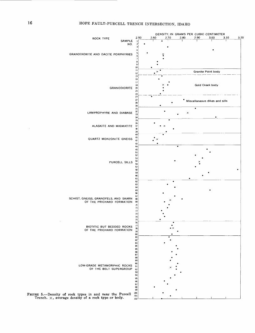
Density and magnetic susceptibility measurements were made for the major rock types in the study area (table 3; figs. 5, 6).
Determinations of saturated bulk densities (fig. 5) show that the average densities for the gabbroic rocks of Purcell sills and the lamprophyre-diabase dike rocks are significantly greater than the other major rock types. The gabbroic rocks averaged 2.92 g/cm3 and are of sufficient mass to produce well- defined gravity maximum anomalies (pi. 1). The lamprophyres and diabases are relatively dense (table 3) ; four samples averaged 2.84 g/cm3 . They are, however, of insufficient volume anywhere in the mapped area to produce anomalies measurable by the wide gravity station spacing.
Thirty-five of the magnetic | values are from the magnetic studies by King, Harrison, and Griggs (1970) in the Packsaddle Mountain quadrangle im mediately to the south. Magnetic properties for 80 samples expressed in terms of magnetization and magnetic susceptibility show that the lamprophyre and diabase rocks and the granodiorite are signifi cantly more magnetic than the felsic varieties or the gabbroic rocks of the Purcell sills (fig. 6). The low values for the gabbro, averaging about 0.0002 emu/cm3 (electromagnetic units per cubic centi meter) susceptibility, are rather surprising, al though Dobrin (1960, p. 269) does show a wide range of values for gabbro, 0.0000681-0.002370, ex pressed in centimeter-gram-second units. King, Har rison, and Griggs noted that the sills showed a neg-
TABLE 3. Physical properties of rocks in and near the Purcell Trench
[Data obtained from hand specimens and cores; two sets of numbers shownwhere two cores from the same sample were measured]
k, magnetic susceptibility in electromagnetic units per cubic centimeter. J, remanent magnetization in electromagnetic units per cubic centimeter. Q, Koenigsberger ratio (J/0.58fc). N.d., no data.
SampleNo. on Density
pi. 1 /cXlO~3 JxlO~4 Q (g/cm3 ) Remarks
Granodiorite and dacite porphyry
10
323334
3536373839
40414243
0.27.66
1.00.60.47
153.751.001.78.79
1.32
0.13
2.431.014.46
0.10.02.03
N.d.2.02
0.02 .04 .02 .02
0.811.27
0.18 .17
2.662.542.703.012.562.672.672.632.632.59
Granodiorite and related rocks
1112
13
14
151617181920212223
24
25
2627282930
1.471.21
.891.18
.071.191.35
.26.23.28.70.39.05.02
1.761.35.36.78.04.05.55.61.35.07.06.07
N.d.-
3.546.20
.30
.32
.119.719.201.11.03.30
!.34!.52.05.09.30.10.14.14.05.08
0.42.89.06.05.27
1.401.17
.74.02.19
.16
.12.22.31.09.03.07.35.13.20
2.662.632.612.61
2.662.642.712.70
2.672.672.652.582.60
2.812.73
2.65
Granite Point bo(Do.Do.Do.Do.
Gold Creek bodyDo.Do.
Do.Do.Do.Do.Do.Do.Do.Do.
Sunnyside dike.Do.
Lightning CreekDo.Do.Do.Do.
Sill.Dike.Granophyric sill.Pegmatite dike.
iy.
body.
Lamprophyre and diabase
0.402.598.61
0.03 .44 .33
2.89 Lamprophyre dike indeformed area.
2.68 Lamprophyre dike. 2.77 Do. 3.03 Diabase dike.
Alaskite and migmatite
2.712.612.652.742.69
Quartz monzonite gneiss
2.672.612.602.63
Gabbroic rocks of the Purcell sills
44 45 46
47
48
49505152
5354
0.08 .07 .11.11.09.10.07
09.04.18
.04
.03
0.11 .09 .04.06.02.36.01.02.06.63
9.23
0.23 .21 .06.09.04.62.03.05.09
1.2
8.84 9.30
2.77 2.97
2.992.89
2.942.75
See footnotes at end of table.

GEOPHYSICAL DATA 15
TABLE 3. Physical properties of rocks in and near the Purcell Trench Continued
Sample No. on pi. 1 fcXlO
Density (g/cm3 ) Remarks
Gabbroic rocks of the Purcell sills Continued
55
565758596061
.07 23.1 56.9
.07 25.0 61.6
.071.18.68.13.08.81
2.922.893.182.982.942.85
Light-colored differentiate.
Schist, gneiss, granofels, and skarn of the Prichard Formation
626364656667
697071
72737475
0.16 .08 .15 .26 .11 .05
.12N.d.2
.02.02
N.d.2 .05 .14
2.74 Gneissic argillitic siltite.2.70 Quartzitic granofels.2.75 Mica schist.2.99 Garnet-quartz skarn.2.67 Quartz granofels.2.75 Biotite-quartz-plagioclase
gneiss.2.80 Schistose argillite.2.68 Quartzitic granofels.2.71 Mica schist.2.70 Biotite-quartz-plagioclase
gneiss.2.66 Mica schist.2.67 Gneissic argillitic siltite.2.68 Schistose argillite.2.65 Do.
Highly biotitic but bedded rocks of the Prichard Formation
767778
7980
0.06.05.30
.14
.08
2.742.732.72
2.772.73
Silty argillite.
argillite and siltite. Do.Do.
86
899091
92
94959697
100
101
102
Low-grade metamorphic rooks of the Belt Supergroup
2.71 Libby Formation silty argillite.
2.72 Libby Formation argillitic siltite.
2.68 Do.2.76 Striped Peak Formation
silty argillite.2.77 Striped Peak Formation
dolomitic siltite. 2.73 Striped Peak Formation
quartzite. 2.76 Wallace Formation
argillite. 2.73 Wallace Formation
silty argillite. 2.72 Do. 2.77 Do. 2.76 Wallace Formation
silty dolomite. 2.76 Wallace Formation
dolomitic siltite. 2.79 Wallace Formation
argillitic siltite. 2.75 Do. 2.72 Do. 2.68 Do.2.70 Wallace Formation siltite. 2.61 Wallace Formation
quartzite. 2.76 St. Regis Formation
silty argillite. 2.67 St. Regis Formation
argillitic siltite. 2.72 Revett Formation
argillitic siltite. 2.66 Revett Formation
quartzite.
1 Core showed unstable remanent magnetism.2 Magnetic susceptibility not detectable by method used.
ligible susceptibility and attributed the lack to alter ation which may have destroyed the initial mag netism. Any significant remanent magnetism (fig. 6) is assumed to be parallel to the earth's field. King, Harrison, and Griggs found the remanent mag
netism to be rather uniformly low with a Koenigs- berger ratio, Q, of 0.2 or less. The few exceptions were attributed to lightning strikes.
. GRAVITY INTERPRETATIONS
The gravity field of the study area shows a variety of trends and local closures that are superimposed on a regional gradient which dips eastward at about 0.5 mgal (milligal) per mile. The regional is defined by a 60-mgal gradient, which extends for about 120 miles from the Kootenay arc mobile belt on the west across the study area and into the block-fault ter- rane of western Montana (fig. 7).
Gravity gradient zones correlate with many of the known faults and provide a basis for projecting other faults across areas covered by alluvium. The north-northeast-trending faults of the Purcell Trench produce gradient zones one gradient zone of 5-10 mgal is well defined along the west wall. In most places the zone is well out in front of the steep topography of the mountain front. The Hope fault, which is nearly normal to the trench, produces many parallel and subparallel gravity trends along its trace. However, it causes little distortion where it crosses the strong north-trending gradient zone of the Purcell Trench.
The northwest-trending strike-slip faults produce intermittent but readily detectable distortions in the predominantly northwest strike of the gravity con tours. The northern of the two faults that merge up Pack River near the mouth of Caribou Creek is well defined by a northwest-trending gravity gradient zone, although wide-spaced gravity control precludes detecting the fault where it crosses the north-north east gradient zone at the mountain front. The causes of the subtle northeastern trends that are shown by the gravity data may be in part due to the configuration of the bedrock surface beneath the surficial deposits. The topographic effects on the gravity data appear to be minor and are not believed to affect the interpretations presented here. The strong topographic control of present valleys by known faults, however, indicates that buried top ography in the Purcell Trench is also fault con trolled.
Many of the discrete gravity anomalies north of the Hope fault are, by correlation with outcrops and by projection in the subsurface, attributed to the high-density gabbroic rocks (2.92 g/cm3 ) of the Purcell sills and the low-density granodiorite (2.67 g/cm ! ) relative to the surrounding Belt rocks (2.72 g/cm3 ). Less dense surficial deposits may contribute to some of the low-amplitude minimum gravity ano-
16 HOPE FAULT-PURCELL TRENCH INTERSECTION, IDAHO
ROCK TYPESAMPLE
NO.
GRANODIORITE AND DACITE PORPHYRIES
LAMPROPHYRE AND DIABASE
QUARTZ MONZONITE GNEISS
PURCELL SILLS
SCHIST, GNEISS, GRANOFELS, AND SKARN OF THE PRICHARD FORMATION
BIOTITIC BUT BEDDED ROCKS OF THE PRICHARD FORMATION
LOW-GRADE METAMORPHIC ROCKS OF THE BELT SUPERGROUP
FIGURE 5. Density of rock types in and near the Purcell Trench, x, average density of a rock type or body.
2.50r
91011
121516 IV 18
GRANODIORITE 20212223
272830
3233343536
ALASKITE AND MIGMATITE 373839404142
4344455152535456575859
DENSITY, IN GRAMS PER CUBIC CENTIMETER 2.60 2.70 2.80 2.90 3.00 3.10 3.20
Granite Point body
Gold Creek body
Miscellaneous dikes and sills
J______L

GEOPHYSICAL DATA 17
MAGNETIZATION, IN emu/err^
10 11 12 >12X10"
o§5
SAMF NO
E-DIS ^
o -o
C3
ide
^ j -0
3
3 (/)
0 ^E "
:5
LE 1 2 3 4 5 6 7 8 9
10'"<
12 <
I 13
1 14 <
15 <
16
117 ,8 19 20 21 22
23 <
' 24<
2s<26r 2?28 29 30
" 31 32 33 34 35 36 37 38 39 40 41 42 43 44 45
46 <
47 <
48 <
49 50 51
52 <
53 54
55 <
56 57 58 59 60 61 62 63 64 65 66 67 68 69 70 71 72 73 74 75 76 77 78 79 80
^
^
,
I
c
^X
* _______________ X
-̂X
** t* X
-»-^< »-x » ̂<K
X
-X « K S>
X 8 y o
^ ," * *
«-^C
»-X X X
^c
^<-X
^<
=^~* x
X^< XK
X
X 1 1 1 1 1
cmCMo o o
k
EXPLANATION
Remanent magnetization
Induced magnetization in earth's field of 0.58 oersted
K is the magnetic susceptibility
1 1 1 1 1 1
FIGURE 6. Magnetization of rocks in and near the Purcell Trench. Sample numbers refer to those given in table 3and shown on plate 1.

18 HOPE FAULT-PURCELL TRENCH INTERSECTION, IDAHO
malies. The loose correlation of some of the gravity anomalies with the outcrops can be attributed partly to the lack of gravity control and to the unknown configuration of the Purcell sills and granodiorite in the subsurface.
Gravity Anomalies
The anomalies are identified by alphabetical let ters on plate 1 and are keyed to the discussions to follow. Anomalies A through H are attributed mainly to gabbroic rocks of the Purcell sills; anomalies I through P, to granodiorite rocks. A. The southwest-trending minimum nosing prob
ably reflects cumulative effects of the sills. B. The maximum closure correlates with the sills. C. The maximum anomaly reflects sills that are
partly buried by Sandpoint Conglomerate. D. The maximum closure may be due to a greater
subsurface extent of the sill outcrop. E. The north-northeast-trending maximum ano
maly correlates with a complex of sills. The maximum trend extends from the closure E north to D, which suggests a fault-controlled block within the trench.
F. The northeast-trending maximum anomaly may be due to a sill in the subsurface southwest of the faulted outcrop. The sill may extend in an arcuate pattern in the subsurface to connect with the sill outcrop at anomaly E.
G. The maximum closure reflects mainly sill out crop.
H. The maximum anomaly correlates with sill out crop.
I. The southwest-trending gravity minimum ano maly may represent a granodiorite mass in the subsurface of considerably greater extent than the small outcrop. A thick section of sur ficial deposits could account for part of the anomaly.
J. The minimum closure may reflect a granodiorite or quartz monzonite body that did not pene trate the thrust plate of Belt rocks. Several hundred feet of preserved sediments could account for the minimum anomaly.
K. The minimum closure may be caused by low density, possibly highly fractured buried granodiorite near the fault intersections. The small outcrop of granodiorite along the Pack River suggests that the surficial deposits are not thick.
L. The minimum anomaly may be due to buried granodiorite. Low-density sediments pre served along the fault would contribute to the anomaly.
M. The minimum closure at M may be caused by the faulting along the west side of the granodi orite and gabbroic sill complex.
N. The minimum anomaly may be caused by a north-trending fault-controlled valley of sedi ments, between masses of high-density Purcell sill.
O. The minimum anomaly may be due to low-den sity fractured granodiorite along the fault zone.
P. The extensive minimum anomaly appears to cen ter over the main mass of the granodiorite batholith.
Q. The minimum anomaly within the Purcell Trench may be caused by a fault-controlled valley which is cut into Sandpoint Conglom erate and which is filled by glacial debris and alluvium.
R. The source of the minimum anomaly on the batholith is unknown. Grus at least 30 feet thick is known in the areas and may contrib ute, along with a thick glacial cover, to the gravity low.
S. The cause of the maximum anomaly is not known.
T. The minimum anomaly may be due to a low- density fracture zone that has been developed along the Hope fault zone.
U. The source of the large maximum anomaly ap pears to be composite. The steep gradient along the northwest side probably is due to the low-density lake fill. The southeastward elongation may be due to a concentration of sills.
V. The minimum nosing may be an expression of a southeast-trending second-order fault branching from the Hope fault.
W. The gravity maximum trend probably repre sents the large highly faulted sill.
MAGNETIC INTERPRETATIONS
The aeromagnetic map (pi. 1) is shown on a bed rock geologic map that was constructed from inter pretation of the geologic and gravity maps of plate 1 as modified slightly by the aeromagnetic data. The aeromagnetic map shows a complex of anomalies superimposed on the regional magnetic field which dips to the southwest in this region at a rate of about 6 gammas per mile (pi. 1).
Magnetic gradient zones and anomaly trends cor relate with most of the major structural features of the area. The gradient zones, often in conjunction with gravity trends, were useful in interpreting the fault patterns beneath surficial deposits. The mag-

GEOPHYSICAL DATA 19
netic data along and to the south of the Hope fault were studied by King, Harrison, and Griggs (1970). They noted that the fault defines a zone of demarca tion between low magnetic gradients on the south and variable but high magnetic anomalies on the northeast (pi. 1). In addition, they concluded that positive magnetic anomalies reflect both exposed and buried granodiorite cupolas and stocks south of the Hope fault and that major faults were expressed by linear negative anomalies. However, north of the Hope fault, in the area of this report, the magnetic field is distorted by porphyry dikes, certain Purcell sills, and exposed and buried granodiorite. The highly magnetic lamprophyres (fig. 6) apparently are not concentrated enough to produce detectable anomalies, but notable magnetic anomalies do cor relate with the porphyry dike swarms and with lim ited areas of unaltered Purcell gabbro. A major negative trough that trends north along the west edge of the area of the data correlates with the seg ment of the Purcell Trench. Some of the northeast ward-trending "grain" in the magnetics can be cor related with trends of the Purcell sills. Most of the northwestward-trending faults that cross the Pur cell Trench are confirmed by the magnetic data. The northernmost fault up Pack River, which was also mentioned in the gravity discussion, is a good example.
The Purcell sills range in composition from quartz diorite to gabbro. The quartz dioritic rocks (such as table 3; samples 53, 54) are altered varieties that commonly contain only 1 percent or less of mag netite and abundant biotite, quartz, and, at some places, sphene, calcite, and epidote. The unaltered gabbro (such as table 3; samples 57, 58) contains as much as 9 percent magnetite and is virtually a hornblende-plagioclase gabbro. The variation in magnetic susceptibility (table 3) correlates well with rock type, degree of alteration, and magnetite content. Isotopic dating of the hornblende also cor relates with the same features in that the quartz diorite of low magnetic susceptibility (table 3; sam ples 53, 54) gives an anomalously low age of 480 m.y. (table 2, sample 7), whereas the freshest gab bro of high magnetic susceptibility (table 3; sam ples 57, 58) gives an older minimum age of 870 m.y. (table 2, sample 6).
Although the terrain is steep, particularly on the east, no topographic effects were detected that would detract from the interpretation.
Magnetic Anomalies
The local magnetic closures and nosings are iden tified on plate 1 by letters. Magnetic anomalies have
been given the same letter as the gravity anomalies (pi. 1). Additional anomalies with no gravity coun terpart are included (letters X, Y, Z, and AA onPi. 1).
B. The positive magnetic anomaly may be caused by buried granodiorite bounded by the gra- ben fault. The outcropping sills in this area probably are not a factor contributing to the anomaly because laboratory measurements show their susceptibility to be negligible (fig. 6).
J. See discussion of W below.M. The positive magnetic anomaly suggests the
presence of more extensive granodiorite and porphyry dikes extending beneath the lake from the outcrop on shore.
R. The cause of the arcuate northeast-trending negative magnetic anomaly is unknown. As for the coincident gravity anomaly, the grus along with a thick glacial cover may con tribute to the negative anomaly.
W. The large magnetic positive anomaly apparent ly is caused by the complex of granodiorite and porphyry dikes. The elongation of the anomaly to the north-northwest and south- southeast correlates with the trend of the dike swarm. It is postulated that the dikes extend northwestward beneath and beyond the Sandpoint Conglomerate and the upper plate of the thrust to the magnetic positive anomaly J which may represent a greater concentration of near-surface dikes beneath the thrust. Anomaly J lies across the rail road tracks, but flightpath photography shows no evidence of a train or other cul tural magnetic disturbances present during the overflights.
X. The positive anomalies correlate with outcrop ping granodiorite; one body of granodiorite is shown on plate 1, and two others are shown on early reconnaissance maps of Anderson (1930, pi. 14) in the area beyond the area of geologic data presented in this report.
Y. Several low-amplitude positive magnetic ano malies over the batholith suggest local mag netite enrichment in exposed and near-sur face granodiorite rocks.
Z. The negative anomalies probably represent de formed Purcell sills of low susceptibility.
AA. The magnetic positive anomalies of 80-100 gammas in amplitude apparently represent Purcell sills of higher than average mag-

20 HOPE FAULT-PURCELL TRENCH INTERSECTION, IDAHO
netite content for this region, which have escaped the excessive deformation and alter ation that may have destroyed much of the magnetite in many of the other sills.
SEQUENCE OF TECTONIC EVENTSA very long and complicated history of folding,
faulting, and intrusion is represented in the mapped area. Within the area, conclusive data on the se quence of several Precambrian events are few, but data on most Cretaceous and Tertiary events seem well documented. We interpret the geologic, geo physical, and isotopic data as indicating the follow ing events:1. Precambrian time: Axial plane faulting of meta
morphosed Belt rocks gently folded on north- trending axes, perhaps accompanied by intru sion of Purcell sills sometime prior to 870 m.y. ago. This faulting included first movement on the ancestral Hope fault. Block faulting at some time before deposition of Cambrian sedi mentary rocks.
2. Late Cretaceous time:(a) Intrusion of the quartz monzonite of the
Kaniksu batholith about 100 m.y. ago. Eastward thrusting, accompanied by re folding, migmatization, and final stages of high-grade metamorphism of Prichard Formation and Purcell sills. East-trend ing upright to overturned folds formed and crossfolded during thrusting.
(b) Emplacement of the granodiorite of the Kaniksu batholith about 95 m.y. ago. The granodiorite intruded through the older thrust plates. It was accompanied by some shouldering aside and consequent local folding where it intruded rocks of the Prichard Formation. Metamorphism in contact zones was largely thermal and occurred in the biotite zone of the green- schist facies.
The intrusion at depth was accompa nied by tectonic swelling over a large area of the United States part of the Kootenay arc at least from the Magee fault zone (King and others, 1970) southeast of Pend Oreille Lake to the Canadian border. Sandpoint Conglomerate formed at the surface as a local torrentially deposited fanglomerate dumped off the east side of the rising Selkirk Mountains into the then-forming Purcell graben. Location of conglomerate probably was controlled by frontal fault north of the Hope fault.
(c) Collapse of the graben as the granodioritecooled.
3. Early Tertiary time: Renewed tension across the Purcell Trench accompanied first by further relative depression of the graben and uplift of the Selkirk Mountains. A total throw on the frontal fault of at least 6,000 feet down on the east is required to allow for derivation of the low-grade metamorphic rocks of the Sandpoint Conglomerate from Prichard rocks once roof ing the intrusives of the Selkirk Mountains. This event was followed closely about 50 m.y. ago by southeast movement of the block north of the Hope fault, which resulted in fan faults from the main fault and tension fractures filled by porphyries. Both the Selkirk Mountains and the Purcell graben were offset several miles right laterally. Dilation appears to have been limited to the area east of the frontal fault and was generally confined to rocks be low the thrusts. Slight eastward tilting of the graben is suggested by the average dip of 25° in the Sandpoint Conglomerate, because an ini tial dip of more than about 15° seems unlikely for a large water-laid fanglomerate unless it represents foreset beds in a deltaic deposit.
The complexity of the intersection between the Purcell Trench and the Hope fault is more clearly understood if viewed in context of the regional framework. The Purcell Trench marks the general eastern border of a highly active tectonic zone. The active zone is old and recurrent, for it represents a positive area that probably occurred during late Belt time (Harrison and Campbell, 1963, fig. 4) and certainly during Windermere time (latest Precam brian) when volcanics and conglomerates were de posited on Belt rocks across the western slope of the Selkirk Mountains northward into Canada. The area of northeastern Washington is also sieved by Cre taceous batholiths and covered in part by Tertiary volcanic rocks. The area thus seems to represent an old crustal hot zone of considerable size that was persistently active at least through the Tertiary.
Thrusting to the east at the edge of the Kootenay arc is not surprising, and its extent may be much greater than indicated by the few faults identified to date. D. T. Bishop (written commun., 1970) iden tified the Strawberry Mountain thrust (the eastern most thrust on pi. 1) in Boundary County. Clark (1967, pi. 1) mapped large overturned to recumbent folds just west of the Purcell Trench along the Pend Oreille River (fig. 1). Although she does not inter pret these structural features as being related to

SEQUENCE OF TECTONIC EVENTS 21
thrusting, her data permit such an interpretation. Rice (1941) showed younger Belt rocks thrust over Prichard (his Aldridge) Formation a few miles west of the Purcell Trench at the international boundary.
REGIONAL IMPLICATIONS
The principal tectonic provinces that involve Belt rocks are shown in figure 7. The simplest of these structurally is the block-fault terrane in which gen erally broad open north-trending folds have been block faulted during Cenozoic time (Pardee, 1950) to form basin-and-range structure and topography. Three major downfaulted areas occur within this terrane the Purcell Trench, which forms the west ern boundary; the Libby Trough, which includes a series of dropped blocks of Cambrian rocks but which is not as pronounced topographically as other trenches; and the Rocky Mountain Trench, which is a graben (Mudge, 1970). On the east is the Mon tana thrust belt, a wide zone of imbricate and com-
117° 116°
plicated thrusts of Cretaceous age (Mudge, 1970). On the west is the Kootenay arc mobile belt, a com plex zone of intense deformation, faulting, intru sion, and extrusion. Superposed on the block-fault terrane and the mobile belt are the Lewis and Clark line (or the Osburn fault zone) and the Hope fault (or fault zone).
Northward in British Columbia, the central sim pler tectonic province is called the Purcell anti- clinorium. It is considered to be bounded on the east by the Rocky Mountain Trench and on the west by the Kootenay arc (Wheeler, 1966, fig. 2-1). A few miles into Canada the apex of the anticlinorium be comes distorted and complicated by extensive thrust ing, folding, and high-grade metamorphism of Pale ozoic and younger ages.
The Purcell Trench appears to be partly a graben and partly a topographic accident. South of Koote nay Lake in British Columbia, Rice (1941, map 603A) showed faults in and near the Purcell Trench
15° 114° 113°
._____ ___ ___CANADA\ V T UNITED "STATES\
\\ !i i i
% ^^ \ HIGH PLAINSx ^ ^
^_
48'
50I
100 MILES _I
FIGURE 7. Principal geologic and tectonic provinces, eastern Washington, northern Idaho, and northwestern Montana.

22 HOPE FAULT-PURCELL TRENCH INTERSECTION, IDAHO
117° 116°
BOUNDARIES OF I IOSBURN FAULT
20 I
Hig-h-ang-le faultShowing relative strike-
slip movement. Dashed where inferred
EXPLANATION
Thrust faultDashed where inferred.
Sfiwteeth an upper plate
Zone of closely spaced high-angle faults
Zone of abundant faultsMostly high angle and ftub-parallel to trend of zone
Principal faults bounding structural trench
FIGURE 8. Major faults in northern Idaho and northwestern Montana. Modified from Bayley and Muehlberger (1968).

REFERENCES CITED 23
that cross the topographic trench at a low angle to the northeast. These faults are on strike with trench faults to the south in northern Idaho (fig. 8). Some trench faults just north of the Hope fault form a graben that contains Sandpoint Conglomerate, as well as older Belt rocks and Purcell sills.
South of the Hope fault, existence of a graben is more speculative. Clark (1967, p. 128) emphasized the relatively low grade of metamorphism of rocks in the "Fish Creek unit" southwest of Cocolalla (pi. 1). She correlated these rocks with the Prichard Formation, and we agree. The anomalously low grade compared with that of metamorphic rocks a few miles to the west may be due to tectonic lower ing in the graben.
Farther south, the trench is broader and less well defined where it joins a broad flat area north of Coeur d'Alene known as Rathdrum Prairie. In this area a major north-trending high-angle fault mapped by Savage (1967, fig. 2A) along Priest Lake and extending several tens of miles to the south probably connects with a north-south fault indicated by a pronounced north-ternding gravity trough (D. L. Peterson, written commun., 1969) found in Rath- drum Prairie. The junction of these major faults (fig. 8) may help explain the location of such a broad valley.
The Purcell Trench in the United States does ap proximate the eastern edge of the Kootenay arc mobile belt. Faulting at the edge of the mobile belt has resulted in a structural trench, partly a graben, whose continuity is certainly topographic but not necessarily that of a single structural feature. Northward into Canada the topographic continuity is obvious, but no single feature controls the trench which may be there because of glacial widening of valleys superposed on the present bedrock or be cause of control by joints rather than by faults.
The pronounced pattern of northwest-trending high-angle faults of northern Idaho and northwest ern Montana (fig. 8) is not cut off at the Purcell Trench as previously supposed. Many of these faults were active during the Cenozoic (Pardee, 1950), but many also appear to be as old as Precambrian and others are Cretaceous in age. Early Tertiary move ment on the Hope fault system is clearly that of northeast blocks moving toward the southeast, which is the reverse of what is required by current theories of the effects of continental drift on this particular continental plate (Hamilton and Myers, 1966, p. 535). Local reactivation of the persistent mobile belt may control the absolute direction of thrusting and dilation in this small part of the crust, which may
be anomalous in terms of continental tectonics.The extent of the Hope fault system to the north
west is not known. It seems clear, however, that this old structural element is a big one in the crustal framework of the northwestern United States.
REFERENCES CITED
Anderson, A. L., 1930, Geology and ore deposits of the Clark Fork district, Idaho: Idaho Bur. Mines and Geology Bull. 12, 132 p.
Barnes, C. W., 1965, Reconnaissance geology of the Priest River area, Idaho: Wisconsin Univ. Ph. D. thesis, 145 p.; abs. in Dissert. Abs., v. 26, no. 9, p. 5365, 1966.
Bayley, R. W., and Muehlberger, W. R., compilers, 1968, Basement rock map of the United States (exclusive of Alaska and Hawaii) : U.S. Geol. Survey Map.
Behrendt, J. C., and Woollard, G. P., 1961, An evaluation of the gravity control network in North America: Geo physics, v. 26, no. 1, p. 57-76.
Calkins, F. C., 1909, A geological reconnaissance in northern Idaho and northwestern Montana, with notes on the economic geology, by D. F. MacDonald: U.S. Geol. Sur vey Bull. 384, 112 p.
Clark, S. H. B., 1967, Structure and petrology of the Priest River-Hoodoo Valley area, Bonner County, Idaho: Idaho Univ. Ph. D. thesis, 137 p.
Daly, R. A., 1906. The nomenclature of the North American Cordillera between the 47th and 53d parallels .of lati tude: Geog. Jour., v. 27, no. 6, p. 586-606.
1912, Geology of the North American Cordillera at the forty-ninth parallel: Canada Geol. Survey Mem. 38 (3 pts.), 857 p.
Dobrin, M. B., 1960, Introduction to geophysical prospecting [2d ed.] : New York, McGraw-Hill Book Co., Inc., 446 p.
Evernden, J. F., and Curtis, G. H., 1965, The potassium- argon dating of Late Cenozoic rocks in East Africa and Italy: Current Anthropology, v. 6, p. 343-385.
Evernden, J. F., and Kistler, R. W., 1970, Chronology of em placement of Mesozoic batholithic complexes in Cali fornia and western Nevada: U.S. Geol. Survey Prof. Paper 623, 42 p.
Fyles, J. T., 1964, Geology of the Duncan Lake area, Lardeau district, British Columbia: British Columbia Dept. Mines and Petroleum Resources Bull. 49, 87 p.
1967, Geology of the Ainsworth-Kaslo area, BritishColumbia: British Columbia Dept. Mines and PetroleumResources Bull. 53, 125 p.
Gabrielse, Hubert, and Reesor, J. E., 1964, Geochronology ofplutonic rocks in two areas of the Canadian cordillera,in Geochronology in Canada: Royal Soc. Canada Spec.Pub. 8, p. 96-138.
Gillson, J. L., 1927, Granodiorites in the Pend Oreille districtof northern Idaho: Jour. Geology, v. 35, no. 1, p. 1-31.
Griggs, A. B., 1964, Purcell trench may be major fault zone,in Geological Survey research 1964: U.S. Geol. SurveyProf. Paper 501-A, p. A89.
Hamilton, Warren, and Myers, W. B., 1966, Cenozoic tec tonics of the western United States: Rev. Geophysics,v. 4, no. 4, p. 509-549.
Hammer, Sigmund, 1939, Terrain corrections for gravimeterstations: Geophysics, v. 4, no. 3, p. 184-194.
Harrison, J. E., 1969, Geologic map of part of the MountPend Oreille quadrangle, Idaho-Montana: U.S. Geol.Survey open-file map.

24 HOPE FAULT-PURCELL TRENCH INTERSECTION, IDAHO
Harrison, J. E., and Campbell, A. B., 1963, Correlations and problems in Belt Series stratigraphy, northern Idaho and western Montana: Geol. Soc. America Bull., v. 74, no. 12, p. 1413-1427.
Harrison, J. E., and Jobin, D. A., 1963, Geology of the Clark Fork quadrangle, Idaho-Montana: U.S. Geol. Survey Bull. 1141-K, 38 p.
1965, Geologic map of the Packsaddle Mountain quad rangle, Idaho: U.S. Geol. Survey Geol. Quad. Map GQ- 375.
Harrison, J, E., and Schmidt, P. W., 1971, Geologic map of the Elmira quadrangle, Bonner County, Idaho: U.S. Geol. Survey Geol. Quad. Map GQ-953.
King, E. R., Harrison, J. E., and Griggs, A. B., 1970, Geo logic implications of aeromagnetic data in the Pend Oreille area, Idaho-Montana: U.S. Geol. Survey Prof. Paper 646-D, 17 p.
Kirkham, V. R. D., and Ellis, E. W., 1926, Geology and ore deposits of Boundary County, Idaho: Idaho Bur. Mines and Geology Bull. 10, 78 p.
Kistler, R. W., Bateman, P. C., and Brannock, W. W., 1965, Isotopic ages of minerals from granitic rocks of the central Sierra Nevada and Inyo Mountains, California: Geol. Soc. America Bull., v. 76, no. 2, p. 155-164.
Larsen, E. S., Jr., Gottfried, David, Jaffe, H. W., and War ing, C. L., 1958, Lead-alpha ages of the Mesozoic batho- liths of western North America: U.S. Geol. Survey Bull. 1070-B, p. 35-62.
Leech, G. B., 1962, Metamorphism and granitic intrusions of Precambrian age in southeastern British Columbia: Canada Geol. Survey Paper 62-13, 8 p.
Meuschke, J. L., McCaslin, W. E., and others, 1962, Aeromag netic map of part of the Pend Oreille area, Idaho: U.S. Geol. Survey open-file map, 2 sheets.
Mudge, M. R., 1970, Origin of the disturbed belt in north western Montana: Geol. Soc. America Bull., v. 81, no. 2, p. 377-392.
Nevin, A. E., 1966, Geology of the paragneiss on the east flank of the Kaniksu batholith, Boundary County, Idaho: Idaho Univ. Ph. D. thesis, 76 p.; abs. in Dissert. Abs., Sec. B., v. 27, no. 11, p. 3995B, 1967.
Obradovich. J. D., and Peterman, Z. E., 1968, Geochronology of the Belt Series, Montana, in Geochronology of Pre cambrian stratified rocks Internat. Conf., Edmonton, Alberta, 1967, Papers: Canadian Jour. Earth Sci., v. 5, no. 3, pt. 2, p. 737-747.
Pardee, J. T., 1950, Late Cenozoic block faulting in western Montana: Geol. Soc. America Bull., v. 62, no. 4, p. 359- 406.
Reid, R. R., and Greenwood, W. R., 1968, Multiple deforma tion and associated progressive polymetamorphism in the Beltian rocks north of the Idaho batholith, Idaho, U.S.A., in Internat. Geol. Cong., 23d, Prague, 1968, Proc. Sec. 4, Geology of Precambrian: Prague, Academia, p. 75- 87.
Reid, R. R., Greenwood, W. R., and Morrison, D. A., 1970, Precambrian metamorphism of the Belt Supergroup in Idaho: Geol. Soc. America Bull., v. 81, no. 3, p. 915-917.
Rice, H. M. A., 1941, Nelson map-area, east half, British Columbia: Canada Geol. Survey Mem. 228. Pub. 2460, 86 p.
Sampson, Edward, 1928, Geology and silver ore deposits of the Pend Oreille district, Idaho: Idaho Bur. Mines and Geology Pamph. 31, 25 p.
Savage, C. N., 1967, Geology and mineral resources of Bon ner County: Idaho Bur. Mines and Geology County Rept. 6, 131 p.
Schofield, S. J., 1915, Geology of Cranbrook map area, British Columbia: Canada Geol. Survey Mem. 76, 245 p.
U.S. Geological Survey, 1969, Aeromagnetic map of the Libby and Mount Pend Oreille quadrangles, Lincoln and Sanders Counties, Montana, and Bonner County, Idaho: U.S. Geol. Survey Geophys. Inv. Map GP-682.
Wheeler, J. 0., 1966, Eastern Tectonic Belt of Western Cordillera in British Columbia, in Tectonic history and mineral deposits of the Western Cordillera: Canadian Inst. Mining and Metallurgy spec. v. 8, 353 p.
White, W. H., 1959, Cordilleran tectonics in British Colum bia: Am. Assoc. Petroleum Geologists Bull., v. 43, no. 1, p. 60-100.
Yates, R. G., Becraft, G. E., Campbell, A. B., and Pearson, R. C., 1966, Tectonic framework of northeastern Wash ington, northern Idaho, and northwestern Montana, in Tectonic history and mineral deposits of the Western Cordillera: Canadian Inst. Mining and Metallurgy spec. v. 8, 353 p.
Yates, R. G., and Engels, J. C., 1968, Potassium-argon ages of some igneous rocks in Northern Stevens County, Washington, in Geological Survey research 1968: U.S. Geol. Survey Prof. Paper 600-D, p. D242-D247.
U.S. GOVERNMENT PRINTING OFFICE ; 1972 O - 455-884