technical memorandum for the downtown brooklyn …...development final environmental impact...
TRANSCRIPT

Page 1
T H E C I T Y O F N E W Y O R K
O F F I C E O F T H E M A Y O R N E W Y O R K , N Y 1 0 0 0 7
Technical Memorandum for the Downtown Brooklyn Development Project1
BAM South Development (a.k.a. Site EE)
CEQR Number 03DME016K
Technical Memorandum 005 (Revised)
I. INTRODUCTION
The purpose of this Technical Memorandum is to determine whether the proposed changes to the
previously approved Downtown Brooklyn Development project would result in any significant adverse
environmental impacts that were not previously identified, either in the April 2004 Downtown Brooklyn
Development Final Environmental Impact Statement (FEIS) or in the Technical Memorandum for BAM
South issued on September 22, 2009, as appropriate.
The program originally analyzed for Site EE in the 2004 FEIS was for 140,000 zsf of community facility
space (Visual and Performing Arts Library), 40,000 zsf of cultural space (theater), 15,000 zsf of retail,
and a 466-space public parking facility below grade. The program and building envelope currently being
proposed for Site EE (Block 2110, Lot 3) are different from the projected development analyzed for that
site in the FEIS. Differences include a change in use from the community facility, cultural and local retail
uses analyzed in the FEIS to a mixed-use building with residential rental units, retail, cinema and other
cultural and community facility uses. In addition, the proposed building would have a maximum height of
approximately 382 feet (32 stories plus mechanical penthouse), compared to the 6-story structure assumed
in the FEIS. Whereas the project analyzed in the 2004 FEIS included a 466-space public parking garage
on the site, the proposed building would include an up to 225-space below-grade garage, of which 64
spaces would be required accessory parking spaces. A detailed description of the proposed development,
which is expected to be completed by the analysis year of 2015, is provided in Section II below.
This memorandum provides a description of the proposed modifications and requested approvals, as well
as a detailed evaluation of the new incremental changes generated by the proposed modifications to the
BAM South development, and assesses the resulting effects on the previous environmental analyses
presented in the 2004 FEIS. The potential impacts of the modifications on each of the technical areas
identified in the CEQR Technical Manual are discussed below. The memorandum uses the most current
2012 City Environmental Quality Review (CEQR) guidelines and thresholds to determine whether the
proposed changes would result in significant adverse environmental impacts not already identified in the
2004 FEIS.
1 This Technical Memorandum was prepared by Philip Habib & Associates, for Two Trees Management Corp.

Technical Memorandum for the Downtown Brooklyn Development FEIS: BAM South Development
CEQR Number 03DME016K (TM005 Revised)
Page 2
As described in the New York State Department of Environmental Conservation’s SEQRA regulations, 6
NYCRR Sections 617.9(a)(7)(i)(a), (b), and (c), and the 2012 CEQR Technical Manual, the lead agency
may require the preparation of a supplemental EIS if there are significant adverse environmental impacts
not addressed or inadequately addressed in the EIS that arise from changes proposed for the project, or
newly discovered information; or a change in circumstances related to the project. This technical
memorandum concludes that there would be no additional significant adverse impacts in any of the
analyzed CEQR technical areas as a result of the development planned for this site.
II. PROJECT DESCRIPTION
2004 Project – Downtown Brooklyn Development
The Downtown Brooklyn Development project was a public planning effort to create opportunities for
stimulating and integrating commercial, academic, cultural, and residential development in the Downtown
Brooklyn area. The 2004 project required a number of discretionary actions that were subject to
environmental review pursuant to CEQR. These actions included:
Zoning map amendments and text changes to the Special Downtown Brooklyn District;
Mapping actions to demap certain streets and widen others;
Amendments to the Brooklyn Center Urban Renewal Plan, MetroTech Urban Renewal Plan, and
Atlantic Terminal Urban Renewal Plan;
Modification of the MetroTech General Large-Scale Development Special Permit;
Disposition of City-owned property pursuant to urban renewal, including Block 2110, Lot 3;
Site selection for a public library (Site EE); and
Special permits for public parking facilities (including one on Site EE).
These actions were projected to stimulate approximately 6.7 million square feet of new development,
including 4.6 million square feet of office space, 979,000 square feet of residential use (approximately
979 units), 844,000 square feet of retail, and 260,000 square feet of community facility and cultural space.
The 2004 project also included provisions for approximately 1,617 public parking spaces, as well as new
public open spaces at several locations.
The New York City Office of the Deputy Mayor for Economic Development and Rebuilding (ODMEDR)
served as the CEQR lead agency for the project’s environmental review. A draft scope of work for the
EIS was presented at a public scoping meeting held on May 20, 2003, and a final scope was issued on
November 3, 2003 that incorporated relevant public comments. A Draft Environmental Impact Statement
(DEIS) for the project was prepared, and the Notice of Completion for the DEIS was issued and the DEIS
was certified and distributed on November 28, 2003. Subsequent to issuance of the Notice of Completion
for the DEIS, it was determined that a Draft Supplemental Environmental Impact Statement (DSEIS)
should be prepared to account for a potential major mixed-use development in the Atlantic Terminal area
– referred to as the Atlantic Yards Arena and Redevelopment project (with Empire State Development
Corporation as the lead agency) – in the future baseline condition. A Positive Declaration and notice of
intent to prepare a DSEIS was issued on January 22, 2004, distributed, published and filed. A public
meeting on the Draft Scope of Work for the DSEIS was held on February 23, 2004, and the Final Scope
of Work for the DSEIS was issued on March 5, 2004. A joint public hearing was held on the DEIS and
the DSEIS on March 24, 2004, in conjunction with the public hearing on the related Uniform Land Use
Review Procedure (ULURP) applications. The Final Environmental Impact Statement (FEIS),
incorporating the Final Supplemental Environmental Impact Statement, was completed, and a Notice of
Completion for the FEIS was issued on April 30, 2004.

Technical Memorandum for the Downtown Brooklyn Development FEIS: BAM South Development
CEQR Number 03DME016K (TM005 Revised)
Page 3
2004 Project – Project Site (Projected Development Site EE) Although the actions proposed as part of the 2004 project affected the entire Downtown Brooklyn project
area, the EIS analysis of changes to allowable use and bulk and other land use provisions was focused on
those sites that were reasonably likely to undergo development within the foreseeable 10-year timeframe
(by 2013). These sites were identified as “projected development sites.” The current BAM South project
site was analyzed as projected development site EE in the 2004 FEIS.
The BAM South project site is bounded by Flatbush and Lafayette Avenues, Ashland and Hanson Places,
is across Ashland Place from the Brooklyn Academy of Music (BAM) Opera House and the
Williamsburg Savings Bank, and is in a C6-1 zoning district within the Special Downtown Brooklyn
District. The project site is identified as Block 2110, Lot 3, and is located within the Atlantic Terminal
Urban Renewal Area in Downtown Brooklyn (Urban Renewal Site 20). As part of the 2004 project
approvals, the amendment to the Atlantic Terminal Urban Renewal Plan revised the ‘Commercial’ land
use designation on this site to allow community facilities and below-grade parking, and changed the FAR
restriction to that permitted pursuant to zoning. As part of the 2004 project, this site was also the subject
of an application for site selection for a new public library for the performing arts (C040185 PSK), as
well as an application for a Special Permit for a below-grade public parking garage with 466 spaces
(C040183 ZSK).
The reasonable worst case development scenario (RWCDS) program analyzed in the 2004 FEIS for this
site consisted of 140,000 zsf of community facility space (Visual and Performing Arts Library), 40,000
zsf of cultural space (theater), 15,000 zsf of retail, and a 466-space public parking facility below grade
(refer to Table 1). At the time, construction of a new six-story, public library for the performing arts, to be
operated by the Brooklyn Public Library, was proposed. The new library would house reading rooms,
archives, galleries, media labs, a 300-seat auditorium, a 99-seat performance space and a 24/7 multimedia
lounge. The library would occupy the southern portion of the lot, with the northern portion of the lot
developed separately as a performing arts building.
2008 Modified Project
As the Brooklyn Public Library advised the City in 2008 that it no longer intended to pursue previous
plans to develop a 140,000 square foot Visual and Performing Arts Library on the site, the City began
considering disposition of the site to a private developer, Two Trees Management Corp. In 2008, Two
Trees proposed constructing a new mixed-use building on the southern portion of the block, with
essentially the same footprint as the project evaluated in the 2004 FEIS, but with some changes in height
as well as proposed uses. Several actions were planned in order to obtain the proposed mix of uses on the
site, including an action to modify the Special Downtown Brooklyn District and/or other zoning actions,
as well as to demap an unbuilt widening of Flatbush Avenue and to preserve an easement for New York
City Department of Transportation use. These modifications were evaluated in a July 2008 Technical
Memorandum, although the zoning actions were never filed.
The development evaluated in the 2008 Technical Memorandum included a total of approximately
374,864 zsf of development, and comprised new residential floor area (190 units) as well as a new hotel
use (approximately 125,928 zsf, 220 rooms). The program also included a 15,000 zsf cinema (with
approximately 600 seats), an approximately 15,000 zsf neighborhood branch library, approximately
12,681 zsf of retail use, and 20,000 zsf of space to be dedicated for cultural uses (art organizations, office,
studio space, etc.). The 2008 program also included a public parking garage with 450 spaces. In addition,
the 2008 program for Site EE included an approximately 25,590 sf public plaza on the northern portion of
the block, which was not included in the 2004 FEIS.

Technical Memorandum for the Downtown Brooklyn Development FEIS: BAM South Development
CEQR Number 03DME016K (TM005 Revised)
Page 4
The structure analyzed in the 2008 Technical Memorandum would have risen to a maximum height of
approximately 495 feet, with a triangular shape reflecting the shape of the site. The lower floors of the
building would have included the cinema, cultural and retail uses, while floors 5 through 12 were
dedicated to the proposed hotel, with 24 floors of residential use above (floors 13 through 36).
A Technical Memorandum for the 2008 project was prepared and issued by the Office of the Deputy
Mayor for Economic Development, the lead agency, on July 14, 2008. The 2008 Technical Memorandum
assessed the environmental effects of the 2008 planned development, and concluded that those changes to
the program for development on Site EE would not result in any significant adverse environmental
impacts that were not identified in the 2004 FEIS.
2009 Modified Project
In 2009, a modified program and building envelope were proposed for Site EE. Several actions were
planned in order to obtain the proposed mix of uses on the site, including an action to modify the Special
Downtown Brooklyn District and other zoning actions, as well as a major modification of a special permit
for a public parking garage, Mayoral approval of the disposition of City-owned property and an
acquisition of real property to allow the City to acquire two portions of the project after construction for
public purposes. These modifications were evaluated in a September 2009 Technical Memorandum.
The previously planned 2009 development included a total of approximately 347,786 zsf of development,
and comprised new residential floor area (400 units). As shown in Table 1 below, the program also
included a 15,000 zsf cinema (with approximately 600 seats), an approximately 15,000 zsf neighborhood
branch library, approximately 25,000 zsf of retail use, and 18,500 zsf of space to be dedicated for
additional cultural uses (art organizations, office, studio space, etc.). The 2009 program also included a
public parking garage with 365 spaces, 101 fewer than what was analyzed in the 2004 FEIS. In addition,
the 2009 program for Site EE included an approximately 13,450 sf public plaza on the northern portion of
the block, which was not included in the 2004 FEIS.
The structure analyzed in the 2009 Technical Memorandum would have risen to a maximum height of
approximately 385 feet, which would mostly occupy the southern portion of the triangular site. The lower
floors of the building would have included the cinemas, cultural and retail uses, while floors 6 through 29
were dedicated to the residential units, with a mechanical penthouse above.
A Technical Memorandum for the 2009 project was prepared and issued by the Office of the Deputy
Mayor for Economic Development, the lead agency, on September 22, 2009. The 2009 Technical
Memorandum assessed the environmental effects of the 2009 planned development and concluded that
those changes to the program for development on Site EE would not result in any significant adverse
environmental impacts that were not identified in the 2004 FEIS. However, the rezoning action was never
filed, and the development was not constructed, although the Mayoral Authorization was completed and
related disposition occurred.
Current Project
The development currently planned for the project site would require a number of discretionary actions
that were not considered in the 2004 FEIS, including:
Zoning Map Amendment
An amendment of the City’s zoning map is being proposed for the subject block bounded by
Lafayette Avenue, Flatbush Avenue, and Ashland Place (Brooklyn Block 2110), changing the

Technical Memorandum for the Downtown Brooklyn Development FEIS: BAM South Development
CEQR Number 03DME016K (TM005 Revised)
Page 5
zoning from C6-1 to C6-2, as illustrated in Figure 1. Under this proposed rezoning, the zoning
map change would expand the existing C6-2 district to the west of the project site one block to
the east, thereby covering the project site in its entirety. The proposed rezoning from C6-1 to C6-
2 would not increase the maximum allowable floor area ratio (FAR) for commercial uses, which
would remain at 6.0 FAR with the proposed rezoning. Similarly, the maximum allowable FAR
for community facility uses or mixed-use buildings would remain unchanged, at 6.5 FAR.
However, the maximum allowable FAR for residential uses would increase from 3.44 under the
current C6-1 zoning to 6.02 with the proposed C6-2 zoning.
Zoning Text Amendment
A zoning text amendment of the Special Downtown Brooklyn District (Article X, Chapter 1 of
the NYC Zoning Resolution) to facilitate the BAM South project that would allow a special
permit for increased floor area for Cultural Use in Certain C6-2 districts (Section 101-80).
Specifically, the proposed special permit would apply only to buildings intended to be occupied
in whole or in part by cultural uses in C6-2 districts east of Flatbush Avenue within the
Downtown Brooklyn Special District. The proposed special permit would allow:
- Maximum Community Facility FAR to be increased from 6.5 to 7.0;
- Permit modifications of the special street wall location regulations of Section 101-41;
- Permit modifications of the height and setback regulations of Section 23-632 as applied to the
residential portion of a building;
- Permit modification of signage regulation.
Zoning Special Permit
A Zoning Special Permit pursuant to Section 101-80, as described above, to facilitate the BAM
South project. The zoning special permit would allow additional floor area for cultural uses, allow
waivers from the street wall requirements along Flatbush Avenue, allow height and setback
waivers, and allow waivers of the underlying signage regulations related to number, size and
location, all under specified conditions through a zoning special permit by the New York City
Planning Commission.
Acquisition of Real Property
An acquisition of real property approval would allow the City to acquire for public purposes two
portions of this project after it is constructed. An approximately 50,000 gsf space within the
building would be acquired to be used for cultural purposes. In addition, an approximately 10,000
sf street-level plaza (a.k.a. City-owned plaza) would be acquired for public use and access to the
cultural uses within the building.
Possible future actions on the project site may include tax exempt financing from either the NYC Housing
Development Corporation (NYCHDC) or NYS Housing Finance Agency (NYSHFA) for the residential
component of the proposed development.
Project Site
The project site encompasses the entirety of a triangular property bounded by Flatbush and Lafayette
Avenues and Ashland Place. The project site, which is denominated as Block 2110, Lot 3 in the Borough
of Brooklyn, has a lot area of approximately 49,830 sf. The current uses located on the property are (i) a
self-park public parking lot for 124 cars, and (ii) a currently vacant former plant and garden supply
facility at the point of the triangle formed by Flatbush Avenue and Ashland Place. The open area at the

2012 Modification Technical Memoarndum for BAM South Development Figure 1
Existing and Proposed Zoning
Source: TEN-Architectos
Area to be Rezoned

Technical Memorandum for the Downtown Brooklyn Development FEIS: BAM South Development
CEQR Number 03DME016K (TM005 Revised)
Page 6
corner of Flatbush and Lafayette Avenues, owned by the City of New York and occupied by the MTA
(Lot 103) through an easement agreement, although part of the zoning lot that is being rezoned, will
remain in City ownership and is not part of the proposed development site being acquired by the
applicant. There is also an illuminated revolving pylon sign and video screen announcing BAM
presentations near the Flatbush and Lafayette Avenue corner. The curb cut for the parking lot,
approximately 25 feet wide, is on Ashland Place over 120 feet from its intersection with Flatbush Avenue.
The only structures on the project site are a small one-story building formerly associated with the now-
vacant garden center and an attendant’s booth in the parking lot. The FAR of these structures is
approximately 0.04.
The project site was disposed by the City of New York, as authorized by Mayoral approval of business
terms through Section 1802(6)(j) of the New York City Charter, and is now owned by the New York City
Economic Development Corporation which has contracted to sell the site to the applicant. The City of
New York will reacquire as condominium units, a 10,000 square foot plaza fronting on Lafayette Avenue
and 50,000 gross square feet (47,055 zsf) of cultural space in the base of the proposed mixed-use building
pursuant to the same contract of sale. There is an easement in favor of the MTA for an area at the corner
of Flatbush and Lafayette Avenues (tax lot 103, which will remain in City ownership and is not part of
the site being developed by the applicant). There are subway tunnels under Flatbush and Lafayette
Avenues and Ashland Place complicating potential below grade development.
Proposed Program
The proposed zoning map and text amendments would allow the applicant, 20 Lafayette LLC, to
construct a new 32-story mixed-use building on the block bounded by Flatbush and Lafayette Avenues
and Ashland Place (the “project site”) in the Downtown Brooklyn Cultural District. The proposed
building would have essentially the same footprint and uses as the previous project evaluated in the 2009
Technical Memorandum, except for the size of the below grade garage.
Table 1 below shows the proposed project program compared to the program for Site EE analyzed in the
2004 FEIS; the program in the 2009 Technical Memorandum is also provided for reference. As shown in
the table, the proposed mixed-use development would include a total of approximately 348,810 zsf of
development, compared to approximately 195,000 zsf analyzed for Site EE in the 2004 FEIS. As shown
in Table 1, the proposed development would reduce the amount of cultural and community facility floor
area on the site by approximately 107,945 zsf compared to the 2004 plan, and would introduce new
residential floor area. Up to a maximum of 402 rental units are conservatively assumed for environmental
analysis purposes, of which approximately 20%, or up to 80 units, are assumed to be affordable.
Similar to the 2009 development, the proposed program is expected to include a 15,000 zsf cinema (with
approximately 600 seats), compared to a 40,000 zsf theater analyzed in the 2004 FEIS. The proposed
program is also expected to include approximately 32,055 zsf of community facility uses including a
neighborhood branch library and space to be dedicated for additional cultural uses (art organizations,
office, studio space, etc.). The amount of retail square footage being proposed is approximately 6,465 zsf
more than what was analyzed in the 2004 FEIS, and the proposed public parking garage would include
241 fewer spaces than what was previously analyzed in the FEIS. In addition, 16,000 sf of publicly-
accessible open space (10,000 sf of which would be City-owned), which were not included in the 2004
FEIS program, would be located on the northern portion of the block.

Technical Memorandum for the Downtown Brooklyn Development FEIS: BAM South Development
CEQR Number 03DME016K (TM005 Revised)
Page 7
TABLE 1
Site EE Program – 2004 FEIS and 2009 Programs vs. 2012 Proposed Development
Land Use
Development
Program Analyzed
for Projected
Development Site
EE in FEIS (ZSF)
Development Program
in Previous Technical
Memorandum – 09/09
(ZSF)
Current Development
Program (ZSF)
Net Difference –
Current Program
Vs. 2004 FEIS
Program (ZSF)
Theater 40,000 zsf (performing
arts)
15,000 zsf (600-seat non-
profit cinema)
15,000 zsf (600-seat non-
profit cinema)
-25,000 zsf
Community
Facility/Cultural 140,000 zsf (library)
33,500 sf (15,000 zsf
library and 18,500 zsf of
additional cultural uses,
TBD)
32,055 sf (including a
library and additional cultural uses, TBD)
-107,945 zsf
Retail/Restaurant 15,000 zsf 25,000 zsf 21,465 zsf 6,465 zsf
Residential - 274,286 zsf (up to a
maximum of 400 dwelling units)
280,289 zsf (up to a
maximum of 402 rental dwelling units)
280,289 zsf (up to a
maximum of 402 dwelling units)
Parking 466-space public
parking garage
365-space public parking
garage
Up to 225-space public
parking garage (and up to
121 bicycle parking spaces)
- 241 parking spaces
Open Space - An approximately 13,450
sf public plaza on northern portion of block
An approximately 16,000
sf publicly-accessible open
space on northern portion of block
16,000 sf publicly-
accessible open space
As noted above, the current plan calls for approximately 15,000 zsf to be occupied by a neighborhood
branch library, and the environmental assessment in this Technical Memorandum assumes that the
Brooklyn Public Library (BPL) is the most likely user for this space. This assumption is based on ongoing
discussions with the BPL, and the fact that the project site has a long history of being considered for a
potential library use, including in the 2004 FEIS (see Table 1 above). However, should this limited
amount of space ultimately be used for another cultural use, the findings of this Technical Memorandum
would not change, as the potential environmental effects of such uses would be essentially the same. As
an example, a library use has a high daily travel demand (40.24 trips per 1,000 sf), which is more than
twice that of cultural/community office space (18 trips per 1,000 sf).
In terms of density, the proposed development would result in a built FAR of approximately 7.0, which
would maximize the development potential of the project site. As such, for environmental analysis
purposes, the proposed development represents the reasonable worst case development scenario
associated with the proposed rezoning.
Current preliminary plans for the building being proposed call for a structure that would rise to a
maximum height of approximately 382 feet (see building section in Figure 2). As shown in Figure 2, the
lower floors of the proposed building would include the cinema, cultural and retail and restaurant uses,
while floors 6 through 32 would accommodate the residential units, with a mechanical penthouse above.
The building’s ground floor would house commercial uses, the residential lobby and cultural use entry.
The tower portion of the building would be set on the eastern portion of the triangular site. The tower’s
footprint is approximately 12,570 square feet.

2012 Modification Technical Memorandum for BAM South Development Figure 2
BAM South Proposed Development - North-South (View Looking East) and East-West (View Looking South) Building Sections
Source: TEN ARQUITECTOS
Hanson Place
Lafayette Avenue
Plaza

2012 Modification Technical Memorandum for BAM South Development Figure 3
BAM South Proposed Development - Ground Floor Plan
Source: TEN ARQUITECTOS

Technical Memorandum for the Downtown Brooklyn Development FEIS: BAM South Development
CEQR Number 03DME016K (TM005 Revised)
Page 8
As shown in the ground floor plan in Figure 3, the entrance/egress to the proposed below-grade garage
would be located on Ashland Place, which is a two-way street with a mapped width of 70 feet (a narrow
street for zoning purposes). Ashland Place would also accommodate the service entrance to the proposed
development, as well as the entrance to the residential component, several retail entrances, as well as a
secondary entrance to the cultural space. The main entrance to the cinema/cultural space would be located
within the proposed plaza along Lafayette Avenue, which would lead to the cultural lobby on the second
floor of the building. The site’s Flatbush Avenue frontage would include retail entrances as well as an
entrance to a restaurant space.
Table 2 below shows the estimate of users (residents and workers) anticipated to be generated by the
proposed development, compared to the estimates assumed in the 2004 FEIS for Site EE and the 2009
Technical Memorandum for the BAM South development. As shown in the table, the proposed
development on Site EE would introduce a total of 119 employees and 844 residents to the site, compared
to 223 employees and no residents for the Site EE program analyzed in the 2004 FEIS, and 132
employees and 840 residents for the 2009 project analyzed in 2009.
TABLE 2
Site EE Occupants – 2004 FEIS and 2009 Technical
Memorandum vs. 2012 Proposed Development
Users On-Site * Site EE in 2004
FEIS
Site EE in 2009
Technical Memorandum 2012 Proposed Development
Community Facility/
Cultural space 180 employees 49 employees 47 employees
Retail 38 employees 63 employees 53 employees
Residential - 840 residents, 16 employees 844 residents, 16 employees
Parking 5 employees 4 employees 3 employees
TOTAL 223 employees 132 employees and 840 residents 119 employees and 844 residents
* Based on rates used in the 2004 FEIS, including: 2.1 residents per unit; 1 worker per 400 sf of general retail; 1 worker per 1,000 sf of community facility and cultural space; 1 worker per 25 dwelling units; and 1 worker per 90 parking spaces.
III. ASSESSMENT OF POTENTIAL ENVIRONMENTAL EFFECTS OF
PROPOSED MODIFICATIONS
This Technical Memorandum uses the 2004 FEIS as the baseline condition for analysis purposes.
However, where more updated information regarding existing (2012) conditions is available, it is used in
this Technical Memorandum, as appropriate. In addition, where applicable, this Technical Memorandum
also utilizes the guidelines and methodologies of the most current 2012 CEQR Technical Manual. As
described below, the proposed revisions to the program for BAM South (Site EE) would not alter the
conclusions for the environmental areas examined in the 2004 FEIS. However, several density-based
technical areas – such as community facilities, open space, traffic and transportation – were further
examined to determine if the proposed development could alter the conclusions of the 2004 FEIS.
As noted above, the current plan calls for approximately 15,000 zsf to be occupied by a neighborhood
branch library, and the environmental assessment in this Technical Memorandum assumes that the
Brooklyn Public Library (BPL) is the most likely user for this space. This assumption is based on ongoing
discussions with the BPL, and the fact that the project site has a long history of being considered for a
potential library use. However, should this limited amount of space ultimately be used for another cultural
3 AV
4 AV
5 AV
6 AV
DEAN ST
FULTON ST
CAR
LTO
N A
V
BERGEN ST
FLATBUSH AV
ATLANTIC AV
DE KALB AV
PARK PL
NEVI
NS S
T
STATE ST
BALTIC ST
ASH
LAN
D P
L
BOND
ST
LAFAYETTE AV
ADE
LPH
I ST
BUTLER ST
S ELLIO
TT PL
PACIFIC ST
FT GR
EEN
E P
L
PROSPECT PL
S PO
RTLA
ND
AV
DE GRAW ST
ST FELIX
ST
SACKETT ST
DOUGLASS ST
WARREN ST
STERLING PLUNION ST
LIVINGSTON ST
ST MARK'S PL
HANSON PL
7 AV
S OXFO
RD
ST
SCHERMERHORN ST
ST JOHN'S PL
RO
CK
WE
LL PL
CU
MB
ER
LAN
D S
T
WYCKOFF ST
GO
LD S
T
HU
DSO
N AV
FLATBUSH
AV EX
GREENE AV
ST MARK'S AV
ELM
PL
LINCOLN PL
WAS
HIN
GTO
N P
K
DU
FFIE
LD S
T
BRID
GE
ST
GROVE PL
TIM
ES P
Z
ACADEMY PK PL
ALBE
E SQ
CU
MB
ER
LAN
D S
T
PACIFIC ST
S OXFO
RD
ST
ST MARK'S AV
°0 500 1,000 1,500 2,000Feet
LegendQuarter Mile Radius
Project Site
Land UseOne & Two Family Buildings
Multi-Family Walkup Buildings
Multi-Family Elevator Buildings
Mixed Commercial/Residential Buildings
Commercial/Office Buildings
Industrial/Manufacturing
Transportation/Utility
Public Facilities & Institutions
Open Space
Parking Facilities
Vacant Land
All Others or No Data
2012 Modification Technical Memorandum for BAM South Development Figure 4
Land Use in the Surrounding Area

Technical Memorandum for the Downtown Brooklyn Development FEIS: BAM South Development
CEQR Number 03DME016K (TM005 Revised)
Page 9
use, the findings of this Technical Memorandum, which are detailed below, would not change, as the
potential environmental effects of such uses would be essentially the same. As an example, a library use
has a high daily travel demand (40.24 trips per 1,000 sf), which is more than twice that of
cultural/community office space (18 trips per 1,000 sf).
Land Use, Zoning, and Public Policy
Land Use
Land use conditions within the Downtown Brooklyn Development FEIS study area were updated to
account for existing conditions and the status of development projects anticipated for completion through
2015. Except for the former garden center, which is now vacant, there have been no changes to the land
use of Site EE, which continues to be occupied mostly by a surface parking lot with a capacity of
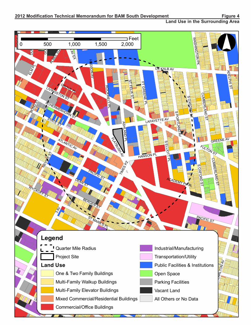
approximately 124 spaces. Figure 4 shows existing land uses within an approximate ¼-mile radius from
the project site.
As noted in the 2009 Technical Memorandum, there has been a trend in both Downtown Brooklyn and
the surrounding study area toward higher-density residential and mixed-use development, a trend that has
thus far been consistent with the scale of development projected and analyzed for Downtown Brooklyn in
the 2004 FEIS. The area shows signs of increased housing activity, evidenced by the number of recently
completed projects and sites under construction. For example, in the immediate vicinity of Site EE, the
Williamsburg Savings Bank building recently underwent conversion from commercial to residential use.
It should also be noted that many of the 32 no-build sites listed in the 2004 FEIS have been completed,
and the programs of two of the larger proposed projects in the area (Brooklyn Bridge Park and the
Atlantic Yards Arena and Redevelopment Project) have been modified since the 2004 FEIS. In addition,
there are a number of additional recently completed projects and projects anticipated to be completed by
2015 in the study area, including initial component of Atlantic Yards (Barclays Arena, which opened in
late September 2012, as well as buildings 1 and 2), various components of the BAM cultural center, and
other development projects in the ¼-mile study area expected to be complete by 2015. This includes the
27,500 sf new home for the Theater for a New Audience (TFANA), currently under construction along
Ashland Place on the block immediately to the north of the project site. When completed in 2013,
TFANA’s new home will include a 299-seat theater, a 50-seat rehearsal space and a lobby cafe. It will
overlook a new public garden plaza and sit along a walking path between BAM’s Opera House and
Harvey Theater.
Similar to the project analyzed in the 2009 Technical Memorandum, the proposed development would
include retail, cultural, and community facility uses, as well as residential uses. The mix of uses in the
proposed development would be compatible with existing and anticipated future uses in the study area, as
the area in the immediate vicinity of Site EE is expected to continue to exhibit a mix of commercial,
residential, and cultural uses. As discussed below, the proposed development would be consistent with the
Downtown Brooklyn cultural district, which is intended to create a vibrant, mixed-use, multicultural arts
district in Downtown Brooklyn. Therefore, the proposed development on Site EE would not result in any
significant adverse impacts on land use, and would not alter the findings of the 2004 FEIS.
Zoning and Public Policy
Since the 2004 FEIS, there have not been any major changes to the zoning or public policy for the
Downtown Brooklyn Development project area. However, a zoning text amendment put forth by DCP for
the Special Downtown Brooklyn District (ULURP # N 120384 ZRK), which is currently undergoing
public review, if approved, would be in effect by the time construction of the proposed project begins in
Technical Memorandum for the Downtown Brooklyn Development FEIS: BAM South Development
CEQR Number 03DME016K (TM005 Revised)
Page 10
2015. The zoning text amendment would reduce the minimum parking requirements for new residential
developments from 40% of new housing units to 20% of new units, to better reflect actual parking
demand in Downtown Brooklyn, which features some of the best transit access in the city. It would also
encourage affordable and mixed-income housing by eliminating parking requirements for affordable
housing units. Finally, the proposed zoning text amendment would simplify the parking regulations in the
Special Downtown Brooklyn District to provide more opportunities for additional public parking for use
by residents, employees and visitors, and would, among other things, permit underground public parking
garages as-of-right up to 225 spaces across Downtown Brooklyn, as is currently allowed for accessory
garages. As such, if the parking text amendment proposed by DCP is approved, the proposed parking
garage for Site EE would be allowed as-of-right, thus eliminating the need for the previously approved
Special Permit for Public Parking Garages.
The actions currently being proposed include rezoning Site EE from C6-1 to C6-2. The proposed rezoning
would not result in a significant change of land use in the area as the uses allowed by the proposed zoning
would be identical to uses that are currently allowed, and would be consistent with existing land use
patterns and trends in the surrounding area. The proposed zoning change would also not result in any new
non-conforming uses.
A zoning text amendment is also being proposed, which would allow additional floor area for cultural
uses, allow waivers from the street wall requirements along Flatbush Avenue, allow height and setback
waivers, and allow waivers of the underlying signage regulations related to number, size and location, all
under specified conditions through a zoning special permit by the New York City Planning Commission.
The actions being proposed will also include a special permit pursuant to the zoning section described
above to facilitate the BAM South project.
The proposed text amendment would apply only to C6-2 zoning districts that are located east of Flatbush
Avenue within the Downtown Brooklyn Special District (and only to buildings intended to be occupied in
whole or in part by cultural uses). As shown in the zoning map in Figure 1, there are no C6-2 districts
within the Downtown Brooklyn Special District located east of Flatbush Avenue, other than the proposed
C6-2 district on the project site. As such, the proposed zoning text amendment would not apply to any
other sites, and no conceptual analysis is warranted. Therefore, the proposed actions and the resulting
proposed development on Site EE are not expected to result in any significant adverse impacts to or
conflicts with zoning in the study area, and would not alter the findings of the 2004 FEIS.
The proposed development would also support and enhance the Downtown Brooklyn cultural district, by
developing an underutilized parking lot site with a vibrant mixed use development, which is anticipated to
include approximately 32,055 zsf of cultural and community facility space, as well as a 15,000 sf (600-
seat) non-profit cinema that will be an extension of the adjacent cultural district. Therefore, the proposed
development on Site EE would not result in any significant adverse impacts on public policy, and would
not alter the findings of the 2004 FEIS.
Waterfront Revitalization Program Site EE is not located within the designated NYC Coastal Zone boundary, and the 2004 FEIS did not
provide an analysis of the project’s consistency with the Waterfront Revitalization Program. The
proposed development would not alter these conditions, and therefore a WRP analysis is not necessary.
Socioeconomic Conditions
According to the 2012 CEQR Technical Manual, a residential development of 200 units or less or a
commercial development of 200,000 sf or less would typically not result in socioeconomic impacts,

Technical Memorandum for the Downtown Brooklyn Development FEIS: BAM South Development
CEQR Number 03DME016K (TM005 Revised)
Page 11
unless it generates socioeconomic conditions that are very different from the prevailing conditions. The
new development currently proposed on the BAM South site would introduce up to a maximum of 402
new residential rental units and approximately 68,520 zsf of other commercial and cultural uses (retail,
restaurant, cinema, and cultural space). Although the proposed development would change the existing
land use on the project site, it is expected to be consistent with the prevailing market conditions and
trends of the area and is not anticipated to adversely impact the socioeconomic character of the
surrounding neighborhood.
As a single site, the proposed development is not likely to trigger any significant changes to the area’s
real estate market. The proposed commercial/cultural uses are relatively small in number (approximately
68,520 zsf of non-residential uses, which falls well below the CEQR threshold of 200,000 sf), and are part
of an ongoing trend, and therefore would not trigger a new trend in real estate conditions.
The residential component of the proposed development (up to a maximum of 402 dwelling units),
although it exceeds the CEQR threshold of 200 units, is not anticipated to cause any indirect residential
displacement resulting from an increase in rental property values. According to the CEQR Technical
Manual, a population increase of less than 5 percent of the total study area population would generally not
be expected to change real estate market conditions in a study area. As shown in Table 2 above, the
proposed development would add approximately 844 residents to the study area. This equates to an
approximately 1.95 percent increase of the study area population in the 2015 analysis year (refer to Table
4 below for estimate of 2015 residential population within a ½-mile radius). Therefore, the Proposed
Development would not introduce a substantial new population that could substantially affect residential
real estate market conditions in the study area, and no further analysis is required.
The development of the project would result in the direct displacement of a public parking lot and the
now vacant garden supply store located at the southern terminus of the property; no residential direct
displacement would occur. Upon completion, the project would replace the public parking garage service
and during construction public parking service would be provided by the public parking garages on
adjacent blocks. As the garden supply store is no longer in business, and there are other garden supply
stores in the neighborhood that provide opportunities for the services to be met, the removal of this
structure is not anticipated to adversely impact the socioeconomic character of the surrounding
neighborhood.
The proposed residential component, which may consist of 20 percent low-income rental units and 80
percent market-rate rental units, would be similar to existing and projected developments in this area of
Downtown Brooklyn, and would not add substantial new population with different socioeconomic
characteristics compared to the size of the existing population. The proposed development also would not
introduce a “critical mass” of non-residential uses so that the surrounding area becomes more attractive as
a residential neighborhood. Furthermore, the proposed development would not introduce a land use that
would offset positive trends in the surrounding area.
As such, the proposed development would not generate any significant adverse impacts to socioeconomic
conditions and no further analysis is warranted. The proposed development would therefore not result in
any additional changes to socioeconomic conditions in the area surrounding the project site compared to
the project analyzed in the 2004 FEIS.
Community Facilities and Services
As stated in the 2012 CEQR Technical Manual, the demand for community services generally stems from
the introduction of new residents to an area. The proposed development for the BAM South site would
introduce up to a maximum of 402 dwelling units to the area, with an estimated 844 residents. Therefore,

Technical Memorandum for the Downtown Brooklyn Development FEIS: BAM South Development
CEQR Number 03DME016K (TM005 Revised)
Page 12
an evaluation of the proposed development’s effects on community facilities is provided below. As
detailed below, the proposed development would not result in any new significant adverse impacts to
community facilities and services, and would not alter the findings of the 2004 FEIS.
Educational Facilities
The 2004 FEIS concluded that there would be ample capacity in surrounding public schools for the
students expected to be generated by the Downtown Brooklyn Development project. As the proposed
development would introduce new residential units to Site EE that were not considered in the 2004 FEIS,
it was evaluated for its potential effects on elementary and intermediate schools in the study area. As
discussed below, the changes proposed to the Site EE program are not expected to alter the conclusions of
the 2004 FEIS.
If an action introduces less than 50 elementary and intermediate school age children, or 150 high school
students, an assessment of school facilities is not required. The screening threshold is higher for high
school students as high school level students can elect to attend schools other than their neighborhood
high schools. The CEQR Technical Manual provides standard student generation rates for residential
developments in each borough. According to Table 6-1a of the 2012 CEQR Technical Manual, a
residential development in Brooklyn would introduce new students at the following rates: 0.29 new
elementary school students per unit; 0.12 new middle school students per unit; and 0.14 new high school
students per unit.
Based on these guidelines, with up to a maximum of 402 dwelling units, approximately 116 elementary
students and 48 intermediate students would be generated by the proposed development, for a total of 164
students, as well as 56 high school students. As the number of elementary/intermediate school students
generated by the proposed development would exceed the CEQR threshold, it was evaluated for its
potential effects on elementary and intermediate schools in the study area.
Site EE is located within the boundaries of Sub-district 3 of Community School District 15 (CSD15). For
an analysis of potential impacts on schools, 2010-2011 capacity and enrollment data for CSD15, Sub-
district 3 were obtained from the Department of Education’s Utilization Profiles. The utilization rate for
public school facilities in the future is calculated by adding SCA’s estimated enrollment from known
future proposed residential developments within Sub-district 3 to the projected enrollment from
NYCDOE, and then comparing that number to projected capacity. In addition, any new school projects
identified in the DOE Five-Year Capital Plan are included if construction has already begun. Table 3
presents 2015 No-Action and With-Action enrollment, utilization, and capacity projections for CSD 15,
Sub-district 3.
Elementary Schools As shown in Table 3 below, with the net additional students generated by the proposed development on
Site EE, elementary schools in Sub-district 3 of CSD15 would have a deficit of 1,743 seats and a
utilization rate of 134.4 percent, an increase of 2.3 over the No-Action condition projected utilization.
Although CSD15, Sub-district 3 elementary schools would operate over capacity, the increase in
utilization would be below the 2012 CEQR Technical Manual significant impact threshold of 5 percent,
as shown in Table 3. The high utilization expected in the sub-district is largely due to No-Action
development expected in the surrounding area, and therefore, the proposed development would not alter
the conclusion of the 2004 FEIS.

Technical Memorandum for the Downtown Brooklyn Development FEIS: BAM South Development
CEQR Number 03DME016K (TM005 Revised)
Page 13
TABLE 3
Estimated Public Elementary and Intermediate School Enrollment, Capacity, and
Utilization Future with Proposed Development on Site EE
2015 No-Action
Total Projected
Enrollment*
Students
Generated
by the
Proposed
Project
Total
Projected
With-
Action
Enrollment
2015
Projected
Capacity
**
With-
Action
Available
Seats
With-
Action
Utilization
(%)
Increase in
Utilization
(%) from
No-Action
condition
Elementary
Schools 6,690 116 6,806 5,063 -1,743 134.4 2.3
Intermediate
Schools 1,430 48 1,478 2,054 576 72.0 2.3
Sources: NYCDOE enrollment projection data (Actual 2008, Projected 2009-2018); NYCDOE 2010-2014 Five-Year Capital Plan, Proposed
February 2012 Amendment
Notes:
* Projected 2015 school enrollment was calculated by applying the CSD 15 percent change from 2010-2015 to the 2010-2011 enrollment for the
elementary and intermediate level schools in the study area. Approximately 28.63 percent of CSD 15’s projected 2015 elementary school enrollment and 27.48 percent of its intermediate school enrollment is estimated to be within Sub-district 3.
** Pursuant to CEQR methodology, existing temporary school facilities were excluded from the future no-action and with-action conditions. No
further changes to school capacity are expected for CSD 15, Sub-district 3.
Intermediate Schools As shown in Table 3, with the net additional students generated by the proposed development on Site EE,
intermediate schools within CSD 15, Sub-district 3 would have 576 available seats and a utilization rate
of 72.0 percent. As Sub-district 3 intermediate schools would be operating below capacity, and the
increase in capacity would represent only a 2.3 percent increase in utilization from the No-Action
condition, below the CEQR threshold of impact significance, the proposed development would not alter
the 2004 FEIS conclusion.
Libraries
The 2004 FEIS concluded that the previously-approved project would not have any significant impacts on
library service. The changes proposed to the Site EE program would not be expected to alter this
conclusion.
According to the guidelines established in the CEQR Technical Manual, if a proposed action increases the
number of residential units served by the local library branch by more than 5 percent, then an analysis of
library services is necessary. In Brooklyn, the introduction of 734 residential units would represent a 5
percent increase in dwelling units per branch. As the proposed development on Site EE would result in
the addition of up to a maximum of 402 dwelling units to the study area, it falls well below the CEQR
threshold for a detailed analysis of 734 units. Therefore, the proposed changes to the Site EE program
would not result in any new significant adverse library service impacts, and would not alter the findings
of the 2004 FEIS.
Hospitals and Public Health Facilities
According to the 2012 CEQR Technical Manual, a detailed assessment of service delivery is conducted
only if a proposed project would affect the physical operations of, or access to and from, a hospital or
public health clinic, or where a proposed project would create a sizeable new neighborhood where none
existed before. As the proposed development on Site EE would be a single-site development, and would
not have any direct effects on hospitals or public health care facilities, it would not meet the threshold for
analysis. Therefore, the proposed development on Site EE would not result in any new significant adverse
impacts to public health facilities.

Technical Memorandum for the Downtown Brooklyn Development FEIS: BAM South Development
CEQR Number 03DME016K (TM005 Revised)
Page 14
Day Care
The 2004 FEIS concluded that the previously-approved project would not have any significant impacts on
day care service. The changes proposed to the Site EE program would not be expected to alter this
conclusion.
The CEQR Technical Manual requires a detailed analysis of day care centers when a proposed action
would produce substantial numbers of subsidized, low- to moderate-income family housing units that
may therefore generate a sufficient number of eligible children to affect the availability of slots at public
day care centers. Typically, proposed actions that generate 20 or more eligible children under age 6
require further analysis. According to Table 6-1 of the 2012 CEQR Technical Manual, the number of DUs
to yield 20 or more eligible children under age 6 in Brooklyn would be 110 affordable housing units. As
the proposed development would contain up to a maximum of 402 units, of which up to 80 units (20%)
could be affordable, it would not exceed the CEQR threshold for public day care analysis. Therefore, the
proposed development on Site EE would not result in any new significant adverse day care impacts, and
would not alter the findings of the 2004 FEIS.
Open Space
No significant adverse open space impacts were identified in the 2004 FEIS. As shown in Table 2 above,
the proposed development on Site EE would introduce a total of 119 employees and 844 residents to the
site, compared to 223 employees and no residents for the Site EE program analyzed in the 2004 FEIS, and
132 employees and 840 residents for the Site EE program analyzed in the 2009 Technical Memorandum.
As the proposed development would generate fewer workers, the proposed modifications would not result
in any new significant adverse impacts within the ¼-mile non-residential study area, and no further
analysis is required for the non-residential population.
As the proposed development would introduce new residential units to Site EE that were not considered
in the 2004 FEIS, it was evaluated for its potential effects on open space resources in the ½-mile
residential study area, in accordance with CEQR Technical Manual guidelines. It should also be noted
that an approximately 16,000 sf (0.37 acres) publicly-accessible open space is currently planned on the
northern portion of the block, which was not included in the 2004 FEIS analysis. As discussed below, the
changes proposed to the Site EE program would not be expected to alter the conclusions of the 2004
FEIS.
It should be noted that the open space analysis in the 2004 FEIS covered a much larger geographic area
(given the size of Downtown Brooklyn rezoning area), and therefore the open space acreage and the
resident and worker populations in the 2004 FEIS study area are significantly larger than those analyzed
for the proposed development of Site EE (see Table 4). Pursuant to the 2012 CEQR Technical Manual,
the open space study area for the proposed development covers the ½-mile area surrounding the project
site (and the census tracts approximately coterminous with this area). While these study areas differ in
geographic size, the open space ratios included in Table 4 provide a means of comparison to determine
the adequacy of publicly-accessible open space per 1,000 persons.

Technical Memorandum for the Downtown Brooklyn Development FEIS: BAM South Development
CEQR Number 03DME016K (TM005 Revised)
Page 15
TABLE 4
Adequacy of Open Spaces in the Residential Study Area—2004 FEIS v. 2012 Updated Conditions
2004 FEIS
(Downtown Brooklyn Study Area)
2012 Updated Conditions
(1/2-Mile Study Area)
No-Action
Condition
2013 With-Action
Condition
No-Action
Condition (1)
2015 With-Action
Condition(2)
Study Area Population
Residents 128,248 130,304 42,405 43,249
Workers 157,954 178,668 40,691 40,810
Total User Population 286,202 308,972 83,096 84,059
Open Space Acreage
Total 137.56 138.71 46.00 46.37
Active 61.79 61.79 23.97 23.97
Passive 75.77 76.92 22.03 22.40
Open Space Ratios
Total 1.073
Per 1,000 residents
1.065
Per 1,000 residents
1.085
Per 1,000 residents
1.072
Per 1,000 residents
Active (Residential) 0.482
per 1,000 residents
0.474
per 1,000 residents
0.565
per 1,000 residents
0.554
per 1,000 residents
Recommended
Weighted Average
Ratio for Passive
0.307 0.298 0.329 0.330
per 1,000 residents
and workers
per 1,000 residents
and workers
per 1,000 residents
and workers
per 1,000 residents
and workers
Combined Passive
(Residents and
Workers)
0.265 0.249 0.265 0.266
per 1,000 residents
and workers
per 1,000 residents
and workers
per 1,000 residents
and workers
per 1,000 residents
and workers
Percent Change in Ratios (No-Action to With—Action)
Total - 0.75% -1.16%
Active (Residents) -1.58% -1.95%
Combined Passive (Residents & Workers) -5.96% 0.51%
(1) No-Action Condition resident and worker populations were calculated by adding future known development within ½ mile of the project site to the
existing population (2010 Census; 2000 Journey to Work data). New residents were calculated assuming 2.1 residents per unit; 1 resident per
dormitory unit; 1 worker per 400 sf of general retail; 1 worker per 1,000 sf of community facility and cultural space; 1 worker per 25
dwelling/dormitory units; 1 worker per 250 sf of office space; 1 worker per 3 hotel rooms; and 1,120 arena employees.
(2) With-Action Condition includes the addition of 844 residents and 119 employees to the study area population as a result of the proposed
modifications, as well as the addition of a 0.37 acre publicly-accessible open space.
As shown in Table 4 above, in the 2004 FEIS, the active open space ratio was expected to decrease by
1.58% from No-Action to With-Action conditions, from 0.48 to 0.47 acres per 1,000 residents. With the
proposed modifications, the active open space ratio is expected to decrease by 1.95% from No-Action to
With-Action conditions, from 0.565 to 0.554 acres per 1,000 residents. While this decrease would be
larger than what was projected in the FEIS, the active open space ratio with the proposed development
would be greater than what was disclosed in the FEIS (0.554 acres per 1,000 residents compared to 0.474
acres per 1,000 residents). As such, the conclusions of the open space analysis in the 2004 FEIS remain
valid, and the proposed development on Site EE would not result in new significant adverse active open
space impacts.
In terms of the combined passive open space ratio, the 2004 FEIS projected a decrease of 5.96% from No-
Action to With-Action conditions, from 0.27 to 0.25 acres per 1,000 residents and workers (see Table 4).
With the proposed development, the combined passive open space ratio would increase by approximately
0.51% from No-Action to With-Action conditions, from 0.265 to 0.266 acres per 1,000 residents and
workers. This increase is due mostly to the new publicly-accessible passive open space included as part of
the proposed development (which was not included in the 2004 FEIS analysis). Therefore, the

Technical Memorandum for the Downtown Brooklyn Development FEIS: BAM South Development
CEQR Number 03DME016K (TM005 Revised)
Page 16
conclusions of the open space analysis in the 2004 FEIS remain valid, and the proposed development on
Site EE would not result in any new significant adverse passive open space impacts.
Shadows
The 2004 FEIS concluded that the Downtown Brooklyn Development project would not have any
significant adverse shadow impacts. As there were no open space resources or sunlight-sensitive historic
resources within the maximum shadow radius of the previous 6-story development of Site EE, no detailed
shadow analysis for Site EE was provided in the 2004 FEIS. As the proposed development would be
significantly taller, at a maximum height of approximately 382 feet, a shadow screening assessment is
provided to determine whether the increased height could reach any open space resources or sunlight-
sensitive historic resources in the area.
The proposed development would be 32 stories (plus a mechanical penthouse) with a maximum height of
382 feet. According to the 2012 CEQR Technical Manual, the longest shadow a structure will cast, except
for periods close to dawn or dusk is 4.3 times its height. At a height of 382 feet, the longest shadow that
would be cast by the proposed development would be approximately 1,643 feet long (Tier 1 Assessment
as per CEQR Technical Manual guidelines). This shadow could potentially be long enough to reach Fort
Greene Park (located approximately 1,206 feet northeast of the project site), as well as several other
smaller open space resources (playgrounds, community gardens, plazas, etc.), and historic resources, as
illustrated in Figure 5. Each of these resources is also identified in Table 5 below.
Location of Buildings Relative to Resources Within Shadow Radius
As the sun rises in the east, the earliest shadow would be case almost directly westward, and shadows
would shift clockwise throughout the day until sunset, when they would fall almost directly east. As
shown in Figure 5, the radius was adjusted to exclude the triangular area south of the project site between
-108 degrees from true north and 108 degrees from true north, as in New York City no shadow can be
cast from a building within this triangular area (Tier 2 Assessment). Any resources that fell outside the
resultant shadow radius were screened out from further consideration, as no shadows cast by the proposed
development would reach it (refer to Table 5 for list of excluded resources).
Resources Within Maximum Shadow Radius
In accordance with CEQR guidelines, the assessment of potential shadow impacts is limited to new
shadows long enough to reach publicly-accessible open spaces or historic resources that have sunlight-
sensitive features (e.g., highly carved ornamentation, stained glass windows, and exterior materials and
color that depend on direct sunlight for visual character). Publicly-accessible open spaces and historic
resources to the north, east, and west of Site EE were identified, as shadows created by the proposed
development could fall in the direction of these resources. It is important to note that only architectural
resources on sites facing the proposed development could be covered by incremental shadows created by
the proposed building. In addition, in accordance with CEQR guidelines, individual historic resources that
lack sun-sensitive features were not considered further.
Two sunlight-sensitive historic resources were identified within a 1,643 foot radius from the site, the
Hanson Place Central Methodist Church and the Baptist Temple. However, it was determined that Hanson
Place Central Methodist Church would not be affected by shadows cast by the proposed development.
The Church, which has a number of stained glass windows, is located to the southeast of the project site,
at the corner of St. Felix Street and Hanson Place, immediately adjacent to the Williamsburg Savings
Bank building, and does not face the proposed modified development. Given its location immediately

6TH
AV
6TH
AV
ATLANTIC COMMON
CU
MB
ERLA
ND
ST
GREENE AV
SO
XFOR
DST
SPO
RTLAN
DAV
CU
MB
ERLA
ND
ST
DE KALB AV
FULTON ST
SO
UTH
ELLIO
TTP
L
SOU
THO
XFOR
DST
SOU
THPO
RTLA
ND
AV
SE
LLIOTT
PL
ATLANTIC AV
FLATBUSHAV
FOR
TG
REE
NE
PL
HANSON PL
PACIFIC ST
TIM
ESPL
Z
PACIFIC ST
4TH
AV
5TH
AV
BERGEN ST
DEAN ST
DEAN ST
PRO
ST. MARK'S AV
WARREN ST
RO
CK
WELL
PL
FULTON ST
DE
BE
VO
ISE
PL
ASH
LAND
PL
FLATBUSH
AV
FOR
TG
RE
ENE
PL
HU
DSO
NAV
LAFAYETTE ST
ST. FE
LIXS
T
ST. MARK'S PL
FLATBUSHAV
GROVE PL
LAFAYETTE AV
NEVI
NSST
BALTIC ST
BUTLER ST
3RD
AV
NEVI
NSST
ST. MARK'S PL
WARREN ST
WYCKOFF ST
ALBE
ESQ
BOND
ST
DE KALB AV
ELM
PL
HANO
VER
PL
!(B
!(D!(C
!(A
Brooklyn Academy of MusicHistoric District
Fort GreeneHistoric DistrictFort Greene
Historic DistrictExpansion
!(E
!(F
!(G
!(H
!(I
!(J
¬«5
¬«13¬«8
¬«2
¬«3
¬«6
¬«12
¬«7
¬«16¬«10
¬«9
¬«1
¬«11¬«14
¬«17 ¬«4
¬«15
108º-108º
° 0 380 760 1,140 1,520Feet
Legend
Area Not Affected by Modified Proposed Development's Shadow
Proposed Development
Development Site!B
State/National Register Historic Resource and/or NYC Landmark (see Table 5)
Open Space Resources (see Table 5)¬«2
Shadow Radius (1,643 feet) Historic Districts
S/NR-Listed Fort Greene Historic Expansion District
2012 Modification Technical Memorandum for BAM South Development Figure 5
Open Spaces and Historic Resources within the Modified Proposed Development's Shadow Radius

Technical Memorandum for the Downtown Brooklyn Development FEIS: BAM South Development
CEQR Number 03DME016K (TM005 Revised)
Page 17
adjacent to the 512-foot tall Williamsburg Savings Bank Building, and the fact that it faces southeast
(away from the project site), it would not be affected by any new shadows cast by the proposed
development, and is therefore excluded from further assessment.
For the remaining resources that were not excluded in the steps above, including the Baptist Temple, a
detailed shadows assessment was conducted, as described below.
Assessment of Potential Shadow Impacts
As directed by the 2012 CEQR Technical Manual, shadows analyses were performed for the remaining
twelve resources (listed in Table 5) for four representative days of the year: March 21/September 21, the
equinoxes; May 6, the midpoint between the summer solstice and the equinox (and equivalent to August
6); June 21, the summer solstice and the longest day of the year; and December 21, the winter solstice and
the shortest day of the year. The CEQR Technical Manual defines the temporal limits of a shadow
analysis period to fall from an hour and a half after sunrise to an hour and a half before sunset. The results
of the shadow analysis on the identified resources of concern are summarized in Table 5, and discussed
below.
March 21/September 21
On the equinoxes, incremental shadows from the proposed development would reach five of the resources
shown in Table 5, mostly in the early morning and late afternoon hours. Incremental shadows would be
cast on the Brooklyn Bears Rockwell Garden for a duration of approximately 2 hours and 26 minutes, and
would exit this garden entirely by 10:44 AM. Incremental shadows would also be cast on Sixteen
Sycamores Playground and the Baptist Temple immediately to its east (7:36 AM to 8:39 AM and 7:36
AM to 8:59 AM, respectively) for a duration of approximately 1 hour and 3 minutes and 1 hour and 23
minutes, respectively. In the afternoon, the proposed development would cast incremental shadows on
Fowler Square for a duration of approximately 45 minutes (3:44 PM to 4:29 PM), and on the open space
at Fulton Street and Fort Greene Place for a duration of approximately 2 hours (2:04 PM to 4:04 PM). No
incremental shadows would be cast on any of the other resources listed in Table 5 on this analysis day.
May 6/August 6
Between the equinoxes and the summer solstice, incremental shadows cast by the proposed development
would reach four of the resources shown in Table 5, all in the morning hours. Incremental shadows would
be cast by the proposed development on Brooklyn Bears Rockwell Garden for a duration of
approximately 57 minutes, and would exit the garden entirely by 10:14 AM. Incremental shadows would
also be cast on Sixteen Sycamores Playground and the Baptist Temple (7:15 AM to 8:07 AM and 6:27
AM to 8:44 AM, respectively) for a duration of approximately 52 minutes and 2 hours and 17 minutes,
respectively; and P.S. 735K/Secret Garden (6:27 AM to 8:49 AM, for a duration of approximately 2 hours
and 22 minutes). No incremental shadows would be cast on any of the other resources listed in Table 5 on
this analysis day.
June 21
On the summer solstice, June 21, the sun is most directly overhead, and shadows are shorter for most of
the day. Incremental shadows cast by the proposed development would reach P.S. 735K/Secret Garden
(entering at 5:57 AM and exiting at 8:52 AM, for a duration of 2 hours and 55 minutes); P.S. 38/The
Pacific School Playground (entering at 5:57 AM and exiting at 6:10 AM, for a duration of 13 minutes);
and the Baptist Temple (entering at 6:54 AM and exiting at 8:33 AM, for a duration of 1 hour and 39

Technical Memorandum for the Downtown Brooklyn Development FEIS: BAM South Development
CEQR Number 03DME016K (TM005 Revised)
Page 18
minutes. No incremental shadows would be cast on any of the other resources listed in Table 5 on this
analysis day.
TABLE 5
Incremental Shadow Duration on Identified Resources
Map
Ref. # Resource Name
March 21/Sept. 21 Timeframe Window –
7:36 AM – 4:29 PM
May 6/August 6 Timeframe Window –
6:27 AM – 5:18 PM
June 21 Timeframe Window –
5:57 AM – 6:01 PM
December 21 Timeframe Window –
8:51 AM – 2:53 PM
Resources Assessed for Potential Shadow Impacts
1 Brooklyn Bears Rockwell Garden 8:18-10:44 9:17-10:14 n/a
9:40-10:15
Incremental shadow duration 2 hrs. 26 mins. 0 hrs. 57 mins. 0 hrs. 35 mins.
2 Sixteen Sycamores Playground 7:36-8:39 7:15-8:07 n/a n/a
Incremental shadow duration 1 hrs. 3 mins. 0 hrs. 52 mins.
3 P.S. 735K at 806/Secret Garden n/a
6:27-8:49 5:57-8:52 n/a
Incremental shadow duration 2 hrs. 22 mins. 2 hrs. 55 mins.
4 Fowler Square 15:44-16:29 n/a n/a
n/a
Incremental shadow duration 0 hrs. 45 mins.
5 Fort Greene Park n/a n/a n/a n/a
6 North Pacific Playground n/a n/a n/a n/a
7 P.S. 38/The Pacific School
Playground n/a n/a 5:57-6:10
n/a
Incremental shadow duration 0 hrs. 13 mins.
11 Greene Garden n/a n/a n/a n/a
12 DOE Playground n/a n/a n/a n/a
14 Macomber Square n/a n/a n/a n/a
17 Fulton Street and Fort Greene
Place Open Space 14:04-16:04
n/a n/a 13:47-14:53
Incremental shadow duration 2 hrs. 0 mins. 1 hrs. 6 mins.
E Baptist Temple 7:36-8:59 6:27-8:44 6:54-8:33 n/a
Incremental shadow duration 1 hrs. 23 mins. 2 hrs. 17 mins. 1 hrs. 39 mins.
Resources Within Area Not Affected by Development Shadows (Area between -108 and 108 degrees)
8 Friends of Pacific Street Garden n/a n/a n/a n/a
9 Warren Street/St. Mark’s
Community Garden n/a n/a n/a n/a
10 South Oxford Playground n/a n/a n/a n/a
13 Wyckoff Gardens Open Space n/a n/a n/a n/a
15 Atlantic Terminal Plaza n/a n/a n/a n/a
16 Brooklyn Bears Pacific Street
Community Garden n/a n/a n/a n/a
A Atlantic Avenue Control House n/a n/a n/a n/a
Historic Resources Screened Out from Further Assessment (Non-Sunlight Sensitive)*
B Dime Savings Bank
C Williamsburg Savings Bank
D Hanson Place Baptist Church
F Pioneer Warehouses
G Buildings at 565-571 Fulton Street
H 308-310 Livingston Street
I Former Public School 15
J Buildings at 522-550 State Street
Brooklyn Academy of Music Historic District (refer to discussion of Hanson Place Central Methodist Church in Technical
Memorandum)
Fort Green Historic District and Expansion
Boerum Hill Historic District
Notes:
* Refer to screening discussion in Technical Memorandum
Times shown are Eastern Standard Time (EST)

Technical Memorandum for the Downtown Brooklyn Development FEIS: BAM South Development
CEQR Number 03DME016K (TM005 Revised)
Page 19
December 21
On the shortest day of the year (winter solstice) when the sun is low in the sky, shadows are the longest
they will be all year. Incremental shadows cast by the proposed development would reach only two
resources on this day: Brooklyn Bears Rockwell Garden (entering at 9:40 AM and exiting at 10:15 AM,
for a duration of 35 minutes), and the open space resource at Fulton Street and Fort Greene Place
(entering at 1:47 PM and exiting at 2:53 PM, for a duration of 1 hour and 6 minutes). No incremental
shadows would be cast on any of the other resources listed in Table 5 on this analysis day.
Assessment
For open spaces, the uses and features of the space indicate its sensitivity to shadows. Shadows occurring
during the cold-weather months of interest generally do not affect the growing season of outdoor
vegetation; however, their effects on other uses and activities should be assessed. Therefore, this
sensitivity is assessed for both (1) warm-weather-dependent features like wading pools and sand boxes, or
vegetation that could be affected by a loss of sunlight during the growing season; and (2) features, such as
benches, that could be affected by a loss of winter sunlight. Uses that rely on sunlight include: passive
use, such as sitting or sunning; active use, such as playfields or paved courts; and such activities as
gardening, or children's wading pools and sprinklers. Where lawns are actively used, the turf requires
extensive sunlight. Vegetation requiring direct sunlight includes the tree canopy, flowering plants and
plots in community gardens. Generally, four to six hours a day of sunlight, particularly in the growing
season (March through October), is often a minimum requirement.
For historic resources, the shadow sensitivity of the sunlight-sensitive features of a historic structure
depends on its design and setting. According to the 2012 CEQR Technical Manual, a significant shadow
impact to historic resources generally occurs when an incremental shadow of 10 minutes or longer falls
on a sunlight sensitive resource and results in a substantial reduction in sunlight available for the
enjoyment or appreciation of the sunlight sensitive features of an historic or cultural resource.
As indicated in Table 5 and discussed above, the proposed development would cast incremental shadows
on several open space resources in one or more of the analysis periods. No incremental shadows would be
cast on Fort Greene Park (the largest open space in the study area) on any of the analysis days. As
detailed above, in many instances these incremental shadows would be cast mostly in the early morning
hours, would quickly dwindle as the sun rises, and would not create a significant adverse shadow impact
on the affected resources. Shadows cast in the afternoon would not exceed 2 hours in duration. As such,
all of the affected open space resources assessed above are expected to receive between four to six hours
of sunlight on the analysis days. Therefore, shadows cast by the proposed development would not result
in a reduction in the usability of any of the existing open space resources identified in the area, nor would
they adversely affect their sunlight-sensitive features.
As noted above, the Baptist Temple, which is located at the southwest corner of Third Avenue and
Schermerhorn Street, would also experience some incremental shadows from the proposed development.
The Baptist Temple contains a large rose window and several stained glass windows on the eastern façade
(facing Third Avenue), as well as several stained glass windows on the northern façade (facing
Schermerhorn Street). Incremental shadows cast by the proposed development would reach the Baptist
Temple on three of the four analysis days. However, those shadows would be cast in the early morning
hours (exiting no later than 8:59 AM on any of the analysis days), and would not exceed a duration of 2
hours and 17 minutes on any of the analysis days. As such, these shadows would not significantly reduce
light to this resource’s stained glass windows, nor would it reduce the public’s enjoyment and
appreciation of those windows. Therefore, the proposed development’s shadows increments on the
Baptist Temple would not have a significant adverse shadows impact.

Technical Memorandum for the Downtown Brooklyn Development FEIS: BAM South Development
CEQR Number 03DME016K (TM005 Revised)
Page 20
It should also be noted that the proposed program for Site EE includes a publicly-accessible open space
on the northern portion of the block. As this open space would be located immediately to the north and
west of the proposed building, it is expected to be cast in shadow only during some periods (mostly in the
morning), on all four analysis days. Because the creation of this open space is part of the proposed
development, these shadows are not considered a significant adverse impact. Moreover, this space would
be designed in the context of its partially shadowed conditions (utilizing shade-tolerant elements, for
example).
Therefore, the incremental shadows resulting from the proposed development would not result in any
significant adverse shadows impacts.
Historic and Cultural Resources
For the 2004 FEIS, the New York City Landmarks Preservation Commission (LPC) determined that Site
EE had no archaeological sensitivity. Therefore, as with the previously approved 2004 project, the current
proposed development would not have any significant adverse effects on archaeological resources. The
Brooklyn Academy of Music Historic District (NYCL and S/NR-listed), and the Williamsburg Savings
Bank building (NYCL and S/NR-listed) are located across the street, within 90 feet of Site EE. However,
the design would locate the mass of the building to allow views of these historic resources. As with the
previously approved project, the proposed development would require a construction protection plan in
order to avoid potential physical impacts to these nearby resources from ground-borne vibrations or other
potential construction-related issues.
As described in the 2004 FEIS, the new, modern development that was projected to occur as a result of
the proposed actions was expected to alter the context of the surrounding architectural resources,
changing it from a mixed context of low-, medium-, and high-rise structures on lots of varied size to one
with a greater concentration of high rise structures on large sites. However, the change in context was not
deemed to constitute a significant adverse impact on architectural resources. As discussed in the “Urban
Design and Visual Resources” section below, the proposed development on Site EE would not alter these
findings, and would therefore not result in any new significant adverse impacts on historic resources.
Moreover, as discussed in the “Shadows” section above, the proposed development is also not anticipated
to result in any significant adverse shadows impacts on any sunlight-sensitive historic resources in the
area.
Urban Design and Visual Resources
The 2004 FEIS did not identify any significant adverse urban design or visual resources impacts for the
Downtown Brooklyn Development project, although the changes to the study area’s urban design and
visual resources were identified as considerable. Although the proposed development would not alter the
footprint of the development on Site EE, it would result in a taller structure, with a maximum height of
382 feet, which would be in close proximity to the Williamsburg Savings Bank building, an iconic
structure, which is approximately 512 feet tall.
The mixed-use building currently proposed on the BAM South site would occupy the triangular site at the
intersection of Flatbush and Lafayette Avenues and Ashland Place in Downtown Brooklyn. Together with
the proposed plaza, located along the northern portion of the project site, the proposed building would
define the gateway to BAM and the new Downtown Brooklyn cultural district. The base of the building
would contain retail and restaurant uses; a cinema, which would be an extension of the adjacent cultural
district; and the residential lobby, located off Ashland Place. An entry/exit ramp off Ashland Place would

2012 Modification Technical Memorandum for BAM South Development Figure 6
BAM South Proposed Development - Massing Study
Aerial view looking north
FOR ILLUSTRATIVE PURPOSES ONLY
Source: TEN ARCHITECTOS

Technical Memorandum for the Downtown Brooklyn Development FEIS: BAM South Development
CEQR Number 03DME016K (TM005 Revised)
Page 21
provide access to the public parking garage on the lower levels. The upper portion of the building would
contain the residential component of the development, with up to a maximum of 402 rental units.
As noted above, the actions being proposed include a zoning special permit pursuant to the proposed
zoning text amendment, to facilitate the BAM South project. The requested special permit would allow
additional floor area for cultural uses on the site, allow waivers from the street wall requirements along
Flatbush Avenue, allow height and setback waivers, and allow waivers of the underlying signage
regulations related to number, size and location.
As shown in the illustrative massing studies in Figure 6, the design of the proposed building would place
the building mass along Ashland Place, and frames the corner of the BAM Opera House, on the one hand,
and the Williamsburg Savings Bank, on the other. By occupying the eastern edge of the lot, the building
would allow maximum sun exposure for the remainder of the site. The building would consist of two
pieces: the cultural base and the residential tower. The translucent building base would allow views into
and through the structure. The roof of the base would be comprised of a series of exterior, terraced levels
that allow access to the cultural program. Together, these design elements would create an active, urban
and public experience along Flatbush Avenue. The terraces would be landscaped and designed so as to
screen the traffic noise from Flatbush Avenue and create a strong visual connection to the publicly-
accessible open space.
As shown in Figure 6, the residential tower would be a narrow structure of angled façade segments. The
tower and the building base would be unified in the choice of materials: the entire structure would be clad
in glass, enhanced by glazing to varying degrees on each of the façade segments. The tower would be
rendered as a solid mass with the angled façade segments converging to points in the center of the eastern
and western facades. Balconies accessible from the tower’s residential units would be visible in the breaks
between façade segments. With such a design, the building would be deferential to its context while
bringing a new urban order and visual identity to the site. Moreover, the urban design character of the
area immediately surrounding the site would be enhanced by the streetscape improvements, including the
16,000 sf publicly-accessible open space on the northern portion of the block.
Like the 2009 development, the proposed building would be more noticeable in surrounding views than
the 6-story library projected on the site in the 2004 FEIS. However, the slim modern profile would
minimize the perceived bulk from most views, particularly street-level views from streets to the south of
the site (see photo montage in Figure 7). The proposed structure would be 130 feet shorter than the
adjacent 512-foot tall Williamsburg Savings Bank, and would therefore not compete with its prominence
in the skyline, nor would it create significant visual obstructions to this iconic landmark. Moreover, the
proposed development would be a modern building utilizing modern materials, and would therefore not
replicate aspects of the landmark Williamsburg Savings Bank building, either in terms of materials, form,
or architectural details, so as to create a false historical appearance.
It should also be noted that the surrounding area’s visual context would change considerably as a result of
the first phase of the Atlantic Yards Arena and Redevelopment project, which is anticipated to be
completed by 2014 and for which the 2009 Modified General Project Plan was affirmed by ESDC on
September 17, 2009. The first phase would introduce five tall buildings, ranging in height from 200 to
511 feet, in the area south of Atlantic Avenue and west of 6th Avenue. These buildings would be
considerably taller than the surrounding buildings in the area, and would thereby alter the Brooklyn
skyline. The proposed development on Site EE, at a height of 382 feet, would be expected to blend in
with these anticipated developments, further contributing to the creation of visual interest and a
distinctive modern skyline.

)htuos gnikool( hsubtalF morf gnikool weiV)htuos gnikool( dnalhsA morf gnikool weiV View looking from Ashland (looking north)
Source: TEN ARQUITECTOSFOR ILLUSTRATIVE PURPOSES ONLY
2012 Modification Technical Memorandum for BAM South Development Figure 7BAM South Proposed Development - Street Level Views
2012 Modification Technical Memorandum for BAM South Development Figure 7
BAM South Proposed Development - North-South (View Looking East) and East-West (View Looking South) Building Sections

Technical Memorandum for the Downtown Brooklyn Development FEIS: BAM South Development
CEQR Number 03DME016K (TM005 Revised)
Page 22
Therefore, although the proposed development would change the context of the study area’s urban design
and visual resources, such changes would not be considered significant adverse impacts. As such, the
findings of the 2004 FEIS relative to urban design and visual resources would not change.
Natural Resources
The 2004 FEIS did not provide an analysis of natural resources, as the project site does not encompass,
nor is it located near, any natural resources such as wetlands, dunes and beaches, grasslands, or
woodlands. The proposed development on Site EE would not alter these conditions, and therefore a
natural resources analysis is not required.
Hazardous Materials
The hazardous materials analysis in the 2004 FEIS identified the potential for VOCs, SVOCs, PCBs,
pesticides, and metals to exist on Site EE, and was therefore deemed to require further investigation to
determine appropriate health and safety and/or remedial measures. The EIS indicated that for Site EE (and
all other City-owned sites), as development will occur through disposition to a private entity, further
investigative and/or remedial activities, as well as health and safety measures, prior to and/or during
construction, will be required under the City’s contract of sale with the private entity selected to develop
the site. The EIS also indicated that E-designations would be placed on lots that were neither City-owned
nor intended for future City-ownership. This mechanism was These mechanisms were determined to
reduce or avoid the potential that significant adverse impacts would result from the proposed action.
In lieu of the inclusion of requirements for further investigative and/or remedial activities in the contract
of sale, the City plans to place an E-designation on Block 2110, Lot 3, which covers the entirety of Site
EE. Pursuant to Section 11-15 of the Zoning Resolution, the E-designation would require, prior to the
New York City Department of Buildings (DOB) issuing permits associated with redevelopment, As such,
prior to developing the site, the developer must to undertake a testing and sampling protocol, and if
necessary, carry out any remediation measures that may be required. As part of this effort, a soil and
groundwater testing protocol will be prepared and submitted to the NYCDEP Bureau of Environmental
Planning and Assessment (BEPA) New York City Mayor’s Office of Environmental Remediation (OER),
for review and approval. Once the protocol is approved, the testing phase and laboratory analysis program
will be undertaken, and a written report with findings and a summary of the data will be submitted to
NYCDEP OER for review and approval. After receiving such test results, a determination will be made
by NYCDEP OER if the results indicate that remediation is necessary. If remediation is indicated from
the test results, a proposed remediation plan must be prepared and submitted to NYCDEP OER for review
and approval prior to execution.
In addition, an DEP OER-approved construction-related health and safety plan would be implemented
during excavation and construction activities to protect workers and the community from potentially
significant adverse impacts associated with contaminated soil and/or groundwater. This Plan would be
submitted to NYCDEP OER for review and approval prior to implementation.
Therefore, with implementation of the above measures, the proposed development is not expected to
result in any new significant adverse hazardous materials impacts that were not previously disclosed in
the 2004 FEIS.
Water and Sewer Infrastructure

Technical Memorandum for the Downtown Brooklyn Development FEIS: BAM South Development
CEQR Number 03DME016K (TM005 Revised)
Page 23
As shown in Table 6a below, the anticipated demands for water and sewage treatment associated with
Site EE would be increased as a result of the proposed development. Compared to the program analyzed
in the 2004 FEIS, the proposed development would result in a net increase in total water demand of
approximately 53,276 gallons per day, and a net increase in wastewater generation of approximately
74,778 gpd.
Water Supply
Given the size of New York City’s water supply system and the City’s commitment to maintaining
adequate water supply and pressures, few actions have the potential to cause significant impacts on this
system. Therefore only very large developments or actions having exceptionally large water demands
(e.g., more than 1 million gallons per day) would warrant a detailed water supply assessment. The
estimated total water consumption resulting from the proposed development on Site EE is well below the
general threshold of 1 million gallons per day typically used to determine the need for a detailed analysis,
and therefore no further analysis is warranted.
TABLE 6a
Expected Water Demand and Wastewater Generation on Site EE –
2004 FEIS vs. 2012 Proposed Program
SITE EE Use Size (zsf)
Domestic Only
(Water Usage/
Wastewater
Generation) (gpd)
Air
Conditioning
Only (gpd)
Total
Water
Demand
(gpd)
2004 FEIS Retail 15,000 3,600
2,550 6,150
Community Facility/Cultural 180,000 18,000
30,600 48,600
Total 21,600 33,150 54,750
2012
Proposed
Development
Residential 402 DU
(280,289 zsf) 84,420 --
84,420
Retail/Restaurant 21,465 zsf 5,152 3,649 8,801
Cinema 600 seats
15,000 zsf 3,600 2,550 6,150
Community Facility 32,055 zsf 3,206 5,449 8,655
Total 96,378 11,648
108,026
Net Difference: 2004 FEIS Vs. 2012 Development 74,778 -21,502 53,276
Notes: Based on average daily water use rates provided in Table 13-2 of the 2012 CEQR Technical Manual. Residential use: 100 gallons per
day (gpd) per resident (assume 2.1 residents per unit). Retail use: 0.24 gpd per square foot, plus 0.17 gpd per sf for air conditioning
(assumes retail rates for restaurant use). Cinema use: 0.24 gpd per square foot, plus 0.17 gpd per sf for air conditioning (assumes retail
rates). Community facility use: 0.10 gpd per square foot, plus 0.17 gpd per sf for air conditioning (assumes office rates).
Wastewater and Stormwater Conveyance and Treatment
For wastewater and stormwater conveyance and treatment, the 2012 CEQR Technical Manual indicates
that a preliminary assessment would be needed if a project is located in a combined sewer area and would
exceed the following incremental development of residential units or commercial space above the
predicted No-Action scenario: (a) 1,000 residential units or 250,000 sf of commercial space or more in
Manhattan; or, (b) 400 residential units or 150,000 sf of commercial space or more in the Bronx,
Brooklyn, Staten Island or Queens. Although the proposed development would result in a net reduction of

Technical Memorandum for the Downtown Brooklyn Development FEIS: BAM South Development
CEQR Number 03DME016K (TM005 Revised)
Page 24
approximately 126,480 sf of non-residential square footage compared to the project analyzed in the 2004
FEIS, it would fall just above the CEQR threshold of 400 residential units.
According to the CEQR Technical Manual, wastewater is considered to include sanitary sewage,
wastewater generated by industries, and stormwater. Water used for air conditioning generates a
negligible amount of wastewater for it is recirculated or evaporates in the cooling and heating process.
The majority of New York City’s wastewater treatment system is comprised of the sewer network
beneath the streets and the 14 wastewater treatment plants (WWTPs) located throughout the city. All 14
WWTPs in New York City have a State Pollution Discharge Elimination System (SPDES) permitted total
capacity of 1.8 billion gallons per day. Sewers beneath the City's streets collect sewage from buildings as
well as stormwater from buildings and catch basins in streets. Collection sewers can be ten inches to two
feet in diameter on side streets, and larger in diameter under other roadways. They connect to trunk
sewers, generally five to seven feet in diameter, which bring the sewage to interceptor sewers. These large
interceptor sewers (often 11 or 12 feet in diameter) bring the wastewater collected from the various
smaller mains to the WWTPs for treatment.
The project site is served by the Red Hook WWTP, which is regulated by SPDES permit to treat and
discharge up to 60 mgd of wastewater. As shown in Table 6a above, the additional expected sanitary
sewage resulting from the proposed modifications, would result in a net increase of approximately 74,778
gpd compared to the project analyzed in the 2004 FEIS. This would represent approximately 0.1 percent
of the WWTP’s dry weather capacity and would not cause the Red Hook WWTP to exceed its design
capacity or SPDES permit flow limit. Per the New York City Plumbing Code (Local Law 33 of 2007),
low-flow fixtures are required to be implemented and would help to reduce sanitary flows from the
project site.
The proposed development would be required to file a site connection proposal for approval to tie into the
sewer system. In accordance with CEQR Technical Manual guidelines, new volumes entering the
combined sewer system as a result of the proposed development were calculated. Using the existing and
proposed site data, the NYCDEP Volume Calculation Matrix was completed for the existing and With-
Action conditions and is summarized in Table 6b. The calculations from the flow volume matrix
determine the wastewater volumes to the downstream sewer system from the existing and With-Action
conditions. Runoff volumes are calculated for four rainfall volume scenarios with varying durations. As
shown in Table 6b, the increase in sanitary sewage discharging from the project site for the four rainfall
volume-duration scenarios, in comparison to existing conditions, would be 0.02 MG, 0.02 MG, 0.05 MG
and 0.08 MG, respectively. The total discharge to the combined sewer system, including stormwater
runoff, would be 0.02 MG, 0.03 MG, 0.08 MG, and 0.15 MG.
TABLE 6b
NYCDEP Volume Calculation Matrix – Existing and With-Action Volume Comparison
Rainfall
Volume
(in.)
Rainfall
Duration
(hr.)
EXISTING WITH-ACTION
Increment
(MG)
49,830 SF (1.14 acres) 49,830 SF (1.14 acres)
Runoff
Vol. Direct
Drainage
(MG)
Runoff
Volume to
CSS
(MG)
Sanitary
Volume to
CSS
(MG)
Total
Volume
to CSS
(MG)
Runoff Vol.
Direct
Drainage
(MG)
Runoff
Volume
to CSS
(MG)
Sanitary
Volume
to CSS
(MG)
Total
Volume
to CSS
(MG)
0.00 3.80 0.00 0.00 0.00 0.00 0.00 0.00 0.02 0.02 0.02
0.40 3.80 0.00 0.01 0.00 0.01 0.00 0.01 0.02 0.03 0.02
1.20 11.30 0.00 0.03 0.00 0.03 0.00 0.03 0.05 0.08 0.05
2.50 19.50 0.00 0.07 0.00 0.07 0.00 0.07 0.08 0.15 0.08
Notes:
Vol. = Volume; CSS = Sanitary to Combined Sewer System; MG = Million Gallons.

Technical Memorandum for the Downtown Brooklyn Development FEIS: BAM South Development
CEQR Number 03DME016K (TM005 Revised)
Page 25
It should be noted that the Flow Volume Matrix calculations do not include any on-site detention Best
Management Practices (BMPs) that would be used to control peak storm discharges per the July 2012
NYCDEP stormwater regulations. Therefore, the actual flow rate to the sewers will be substantially less
than the rate extrapolated from the volume matrix. On-site detention would be required for this site as a
part of the DEP site connection approval process. The following section discusses the potential BMPs that
could be suitable for implementation for the proposed development.
The project site is located in an area that is very well served by combined sewer infrastructure. The
Brooklyn Sewer Map (see Figure 8) shows that there is a 12-inch combined sewer in Flatbush Avenue
immediately adjacent to the project site that begins at the southern tip of the project site, with a capacity
of approximately 3.2 cfs; Lafayette Avenue immediately adjacent to the project site also has a 12-inch
combined sewer that begins at the northeastern tip of the site with a similar capacity. As this total capacity
is well in excess of the 0.23 cfs (0.15 MG) flow per the matrix, the two existing 12-inch combined sewers
are ample to serve the site. Both 12-inch combined sewers connect to a 42-inch combined sewer main at
Lafayette Street and Rockwell Place, just north of the site. Two blocks north of the project site, this 42-
inch combined sewer connects to a 60-inch combined sewer main on DeKalb Avenue. Given the size of
the existing sanitary sewer facilities in the vicinity of the site, there is ample capacity in the adjacent
sewer infrastructure to accommodate the additional sanitary sewage generated by the proposed
development. Therefore, the proposed development on Site EE would not result in any new significant
adverse infrastructure impacts, and would not alter the findings of the 2004 FEIS.
Stormwater Best Management Practices
NYCDEP amended Chapter 31 of Title 15 of the Rules of the City of New York (RCNY), the existing
rules governing house and site connections to the city’s sewer system. The rule amendment modifies the
flow rate of stormwater to the city’s combined sewer system for new and existing development, as part of
sewer availability and connection approvals, and applies to development lots where new buildings or
alterations of existing buildings that would result in an expansion of building footprint or impervious
surfaces are proposed. The rule was promulgated on January 4, 2012 and went into effect on July 4, 2012.
For a new development, the Stormwater Release Rate will be the greater of 0.25 cubic feet per second
(cfs) or 10% of the Allowable Flow, unless the Allowable Flow is less than 0.25 cfs, in which case the
Stormwater Release Rate shall be the Allowable Flow.
The proposed development on Site EE would implement stormwater best management practices (BMPs)
to limit the discharge to 0.25 cfs or 10% of the allowable flow from the project site. BMPs that could be
employed for the project include green roofs and blue roofs, subsurface detention, or a combination of the
three. Stormwater management BMPs could include on-site detention facilities (such as underground
storage tanks and tanks within the buildings) and vegetated areas over underground structures. On-site
detention tanks would be used to store water for gradual release during rain events, freeing up capacity in
combined sewers. Infiltration of stormwater through subsurface soils is not feasible on the majority of the
open space on the project site, since most of the vegetated areas would be located above underground
structures. Vegetated areas located above underground structures, however, would still lower the potential
runoff through soil retention and evapotranspiration, which is the return of water to the atmosphere from
surfaces (evaporation) and vegetation (transpiration).
The final BMP selection for implementation would be undertaken during the detailed design phase, in
coordination with NYCDEP, when site characteristics are better defined. The selected BMPs would be
used together to achieve an overall release rate of 0.25 cfs or 10 percent of the allowable flow rate
(whichever is greater) from the project site. With the incorporation of selected BMPs, the stormwater
runoff would not be expected to have an impact on the downstream City combined sewer system or the
City sewage treatment system.

2012 Modification Technical Memorandum for BAM South Development Figure 8 Brooklyn Sewer Map
PROJECT SITE
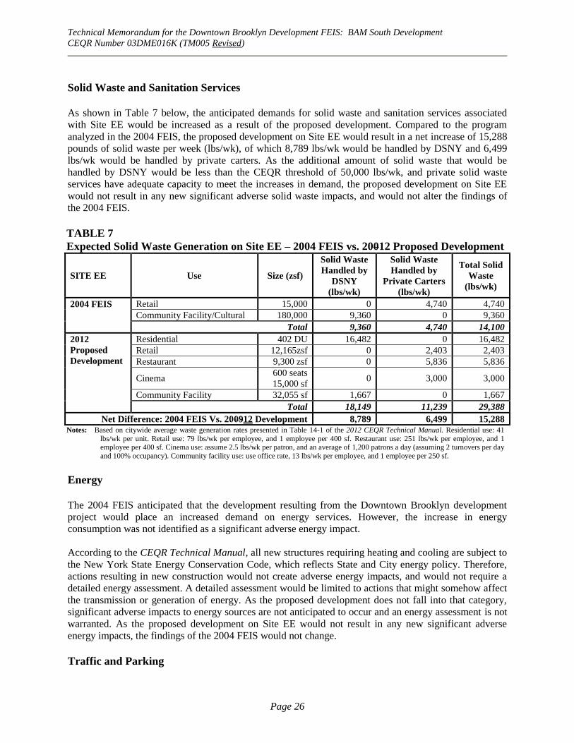
Technical Memorandum for the Downtown Brooklyn Development FEIS: BAM South Development
CEQR Number 03DME016K (TM005 Revised)
Page 26
Solid Waste and Sanitation Services
As shown in Table 7 below, the anticipated demands for solid waste and sanitation services associated
with Site EE would be increased as a result of the proposed development. Compared to the program
analyzed in the 2004 FEIS, the proposed development on Site EE would result in a net increase of 15,288
pounds of solid waste per week (lbs/wk), of which 8,789 lbs/wk would be handled by DSNY and 6,499
lbs/wk would be handled by private carters. As the additional amount of solid waste that would be
handled by DSNY would be less than the CEQR threshold of 50,000 lbs/wk, and private solid waste
services have adequate capacity to meet the increases in demand, the proposed development on Site EE
would not result in any new significant adverse solid waste impacts, and would not alter the findings of
the 2004 FEIS.
TABLE 7
Expected Solid Waste Generation on Site EE – 2004 FEIS vs. 20012 Proposed Development
SITE EE Use Size (zsf)
Solid Waste
Handled by
DSNY
(lbs/wk)
Solid Waste
Handled by
Private Carters
(lbs/wk)
Total Solid
Waste
(lbs/wk)
2004 FEIS Retail 15,000 0 4,740 4,740
Community Facility/Cultural 180,000 9,360 0 9,360
Total 9,360 4,740 14,100
2012
Proposed
Development
Residential 402 DU 16,482 0 16,482
Retail 12,165zsf 0 2,403 2,403
Restaurant 9,300 zsf 0 5,836 5,836
Cinema 600 seats
15,000 sf 0 3,000 3,000
Community Facility 32,055 sf 1,667 0 1,667
Total 18,149 11,239 29,388
Net Difference: 2004 FEIS Vs. 200912 Development 8,789 6,499 15,288 Notes: Based on citywide average waste generation rates presented in Table 14-1 of the 2012 CEQR Technical Manual. Residential use: 41
lbs/wk per unit. Retail use: 79 lbs/wk per employee, and 1 employee per 400 sf. Restaurant use: 251 lbs/wk per employee, and 1 employee per 400 sf. Cinema use: assume 2.5 lbs/wk per patron, and an average of 1,200 patrons a day (assuming 2 turnovers per day
and 100% occupancy). Community facility use: use office rate, 13 lbs/wk per employee, and 1 employee per 250 sf.
Energy
The 2004 FEIS anticipated that the development resulting from the Downtown Brooklyn development
project would place an increased demand on energy services. However, the increase in energy
consumption was not identified as a significant adverse energy impact.
According to the CEQR Technical Manual, all new structures requiring heating and cooling are subject to
the New York State Energy Conservation Code, which reflects State and City energy policy. Therefore,
actions resulting in new construction would not create adverse energy impacts, and would not require a
detailed energy assessment. A detailed assessment would be limited to actions that might somehow affect
the transmission or generation of energy. As the proposed development does not fall into that category,
significant adverse impacts to energy sources are not anticipated to occur and an energy assessment is not
warranted. As the proposed development on Site EE would not result in any new significant adverse
energy impacts, the findings of the 2004 FEIS would not change.
Traffic and Parking

Technical Memorandum for the Downtown Brooklyn Development FEIS: BAM South Development
CEQR Number 03DME016K (TM005 Revised)
Page 27
The 2004 FEIS determined that the Downtown Brooklyn Development project would result in the
potential for significant adverse traffic impacts at 29 signalized intersections in one or more peak periods.
Out of these 29 intersections, 5 intersections were located in the immediate vicinity of Site EE, including:
Atlantic Avenue at Flatbush Avenue, Atlantic Avenue at 4th Avenue, Flatbush Avenue at Livingston
Street, Flatbush Avenue at 4th Avenue/Hanson Place, and Flatbush Avenue at Schermerhorn
Street/Lafayette Avenue. Mitigation measures were proposed in the 2004 FEIS that would fully or
partially mitigate these impacts.
It should be noted that, subsequent to approval of the 2004 project, NYCDOT initiated a number of
street/safety improvements in the vicinity of Site EE. These included the conversion of Lafayette Avenue
to one-way eastbound travel between Flatbush and Fulton avenues, simplifying the intersections of
Lafayette at Flatbush Avenue and Fulton Street. Given the curb alignment of the adjacent block to the east
of the project site (between Ashland Place and St. Felix Street), the right travel lane on Lafayette Avenue
adjacent to the project site was converted to a right-turn lane onto Ashland Place. In the No-Action
condition, it is expected that the northern curb of the project site would be extended to the north, to be
consistent with the alignment of the adjacent block, and the right-turn lane would be eliminated. This
configuration would remain the same in the future with the proposed development.
Because the proposed development would include new uses (residential) and reduce the square footage of
the uses previously projected for this site in the 2004 FEIS (cultural, community facility), a new
preliminary traffic and parking assessment is necessary to determine if the revised program would exceed
the CEQR threshold of 50 net action-generated vehicle trips per hour (vph) in the surrounding area. A
preliminary trip generation forecast was used to determine potential changes in impacts on traffic and
parking in the area surrounding the BAM South site as a result of the proposed development on Site EE.
Traffic
Table 8 shows the transportation planning assumptions used to forecast how many vehicle trips per hour
the proposed development would be likely to generate in the surrounding area, and Table 9 shows the
total net travel demand for the proposed development and compares it to the 2004 FEIS travel demand for
Site EE; a comparison with the travel demand for the 2009 project is also provided for reference. As the
specific uses that would comprise the approximately 17,055 zsf of additional cultural space are not known
at this time, the planning assumptions for an office use were assumed for that component.
As shown in Table 9, the proposed development would generate a total of approximately 36, 57, and 71
vph during the weekday AM, midday and PM peak hours, respectively, compared to 15, 69, and 53 vph
for the project analyzed for Site EE in the 2004 FEIS. Therefore, as shown in Table 9, the incremental
change resulting from the proposed development would be 21, -12, and 18 vph during the AM, midday
and PM peak hours, respectively, compared to the 2004 FEIS. It is important to note, however, that the
proposed reduction in off-street parking spaces on the project site (225 spaces compared to 466 spaces
assumed in the 2004 FEIS) is expected to result in a decrease in project-related traffic at intersections in
the immediate vicinity of the site. This would likely offset most if not all of the small increase in AM and
PM peak hour vehicular demand in the vicinity of the project site associated with the proposed new uses.
Even without accounting for this expected reduction in traffic, the net increments resulting from the
proposed development (shown in Table 9) fall below the 50 vph CEQR Technical Manual threshold in
peak hours, and are therefore not expected to result in any significant adverse traffic impacts not already
disclosed in the 2004 FEIS.
Parking

Technical Memorandum for the Downtown Brooklyn Development FEIS: BAM South Development
CEQR Number 03DME016K (TM005 Revised)
Page 28
The proposed development would include a new public parking garage with up to 225 spaces (compared
to 466 for the 2004 approved project and 365 for the 2009 project); 64 of the 225 parking spaces would be
required accessory spaces. As discussed below, the proposed development would result in a parking

Technical Memorandum for the Downtown Brooklyn Development FEIS: BAM South Development
CEQR Number 03DME016K (TM005 Revised)
Page 29
TABLE 8
Proposed Modified Development Site EE—Transportation Planning Assumptions
La nd Us e : Lo c a l R e ta il R e s ide nt ia l C ine m a C ultura l Us e s C ultura l Us e s
(Libra ry) (Off ic e )
S ize / Units : 21,465 zs f 402 DU 600 s ea ts 15,000 zs f 17,055 zs f
15,000 zs f
Trip Ge ne ra t io n: ( 1) ( 1) ( 1) ( 2) (1)
Weekday 205 8.075 3.26 40.24 18
per 1,000 s f per 1,000 s f per s ea t per 1000 s f per 1000 s f
Te m po ra l D is tribut io n: ( 1) ( 1) ( 1) ( 2) (1)
AM 3.0% 10.0% 0.0% 0.6% 12.0%
MD 19.0% 5.0% 3.0% 11.5% 15.0%
P M 10.0% 11.0% 8.0% 10.3% 14.0%
( 2) ( 3) ( 4) ( 2) (5)
M o da l S plit s : AM/MD/P M AM/MD/P M AM/MD/P M AM/MD/P M AM/P M MD/SAT
Auto 2.0% 9.1% 32.0% 15.0% 12% 2%
Taxi 3.0% 0.2% 4.0% 0.0% 1% 1%
Subway 4.0% 72.1% 22.0% 30.0% 65% 7%
Bus 6.0% 3.4% 20.0% 15.0% 6% 7%
Walk/Other 85.0% 15.2% 22.0% 40.0% 16% 83%
100.0% 100.0% 100.0% 100.0% 100% 100%
( 2) ( 2) ( 4) ( 2) (5)
In/ Out S plit s : In Out In Out In Out In Out In Out
AM 50% 50% 20.0% 80.0% 50% 50% 100% 0% 96% 4%
MD 50% 50% 51.0% 49.0% 62% 38% 71% 29% 39% 61%
P M 50% 50% 65.0% 35.0% 54% 46% 24% 76% 5% 95%
Ve hic le Oc c upa nc y: ( 2) ( 3) ( 4) ( 2) (5)
Auto 2.00 1.17 2.3 2.7 1.42
Taxi 2.00 1.4 2.4 2.7 1.42
Truc k Trip Ge ne ra t io n: ( 1) ( 1) (6) ( 2) (1)
0.35 0.06 0.40 0.29 0.32
per 1,000 s f per DU per s f per 1000 s f per 1000 s f
( 1) ( 1) ( 6) ( 2) (1)
AM 8.0% 12.0% 0.0% 10.0% 10.0%
MD 11.0% 9.0% 2.0% 11.0% 11.0%
P M 2.0% 2.0% 6.8% 2.0% 2.0%
In Out In Out In Out In Out In Out
AM/MD/P M 50.0% 50.0% 50.0% 50.0% 50.0% 50.0% 50.0% 50.0% 50.0% 50.0%
N o tes :
( 1) 2012 City Enviro nmenta l Quality Review (CEQR) Technica l Manual.
( 2) Do wnto wn Bro o klyn Develo pment FEIS, April 2004.
( 3)
( 4) Lo ews Elmhurs t Multiplex , FEIS, J an. 2000
( 5) Atlantic Yards Arena and Redevelo pment P ro jec t EIS , No vember 2006.
( 6) Batte ry P ark City F ina l Fo uth Supplement to the FEIS, No vember 1996.
Mo dal s plit and vehic le o ccupancy da ta a re bas ed o n ACS (American Co mmunity Survey) Data 2010 5-
years Es timate fo r trac ts 33, 35, 37, 39, 41, 129.01 and 129.02.

Technical Memorandum for the Downtown Brooklyn Development FEIS: BAM South Development
CEQR Number 03DME016K (TM005 Revised)
Page 30
TABLE 9
Proposed Modified Development Site EE—Trip Forecast Summary
Land Use:
(Library) (O ffice)
Size/Units: 21,465 zsf 402 DU 600 seats 15,000 zsf 17,055 zsf
15,000 zsf
Peak Hour Trips:
AM 132 325 0 4 37 497
MD 836 162 59 69 46 1,173
PM 440 357 157 62 43 1,060
Person Trips:
In Out In Out In Out In Out In Out Total
AM Auto 1 1 6 24 0 0 1 0 4 0 37
Taxi 2 2 0 1 0 0 0 0 0 0 5
Subway 3 3 47 187 0 0 1 0 23 1 265
Bus 4 4 2 9 0 0 1 0 2 0 22
Walk/O ther 56 56 10 39 0 0 1 0 6 0 168
Total 66 66 65 260 0 0 4 0 35 1 497
In Out In Out In Out In Out In Out Total
MD Auto 8 8 8 7 12 7 7 3 0 1 61
Taxi 13 13 0 0 1 1 0 0 0 0 28
Subway 17 17 60 57 8 5 15 6 1 2 188
Bus 25 25 3 3 7 4 7 3 1 2 80
Walk/O ther 355 355 13 12 8 5 20 8 15 23 814
Total 418 418 84 79 36 22 49 20 17 28 1,171
In Out In Out In Out In Out In Out Total
PM Auto 4 4 21 11 27 23 2 7 0 5 104
Taxi 7 7 0 0 3 3 0 0 0 0 20
Subway 9 9 167 90 19 16 4 14 1 27 356
Bus 13 13 8 4 17 14 2 7 0 2 80
Walk/O ther 187 187 35 19 19 16 6 19 0 7 495
Total 220 220 231 124 85 72 14 47 1 41 1,055
Vehicle Trips :
In Out In Out In Out In Out In Out Total
AM Auto (Total) 1 1 5 21 0 0 0 0 3 0 31
Taxi (Balanced) 2 2 1 1 0 0 0 0 0 0 6
Truck 0 0 1 1 0 0 0 0 0 0 2
Total 3 3 7 23 0 0 0 0 3 0 39
In Out In Out In Out In Out In Out Total
MD Auto (Total) 4 4 7 6 5 3 3 1 0 1 34
Taxi (Balanced) 11 11 0 0 0 0 0 0 0 0 22
Truck 0 0 1 1 0 0 0 0 0 0 2
Total 15 15 8 7 5 3 3 1 0 1 58
In Out In Out In Out In Out In Out Total
PM Auto (Total) 2 2 18 9 12 10 1 3 0 4 61
Taxi (Balanced) 5 5 0 0 2 2 0 0 0 0 14
Truck 0 0 0 0 0 0 0 0 0 0 0
Total 7 7 18 9 14 12 1 3 0 4 75
2004
FEIS
2009
Tech
Memo
Total Vehicles In Out Total Total Total Difference <50
AM 10 26 36 15 51 -15
MD 31 26 57 69 81 -24
PM 40 31 71 53 91 -2018
Proposed Project
Local Retail Residential Cultural UsesCinema TO TAL ALL
USES
Difference <50
21
-12
Proposed Project
Vs. 2004 FEIS
NET DIFFERENCE -
Cultural Uses
Proposed Project Vs. 2009
Tech Memo

Technical Memorandum for the Downtown Brooklyn Development FEIS: BAM South Development
CEQR Number 03DME016K (TM005 Revised)
Page 31
deficit that is smaller than that projected in the 2004 FEIS, and therefore the findings of the 2004 FEIS
relative to off-street parking would not change due to the reconfigured garage on the project site.
The anticipated hourly parking demand associated with all of the different components of the proposed
development is presented in Table 10. As shown in the table, the maximum parking demand associated
with the proposed development would be approximately 87 spaces in the 8-9 AM peak hour, 95 spaces in
the 12-1 PM peak hour, and 116 spaces in the 5-6 PM peak hour. This is higher than the parking demands
identified for Site EE in the 2004 FEIS (3 in the AM, 61 in the midday, and 50 in the PM). It should be
noted however that, whereas the public demand associated with the cultural use assumed for Site EE in
the 2004 FEIS peaked during the midday period, the parking demand associated with the predominantly
residential proposed development would peak during the evening and overnight hours. As shown in Table
10, the garage’s peak utilization (149 spaces) from project-generated demand would occur during the 8-9
PM period, mostly due to the cinema component of the development.
Table 10
Proposed Modified Development on Site EE—Hourly Parking Demand-Weekday
With an up to 225-space public parking facility on-site, of which 64 spaces would be required accessory
spaces, the demand generated by the proposed development would be readily accommodated by this
facility. In addition, it is assumed that some or all of the current demand from the existing 124-space
parking lot on Site EE would also utilize the new garage. Although the 2004 FEIS showed a midday
utilization of 94 spaces for this facility (which was assumed to have a capacity of 110 spaces), recent field
surveys conducted in November 2011 and February 2012 indicate that this parking lot currently has a
utilization of 124 spaces in the weekday midday, 101 spaces in the weekday evening, and 74 spaces
Cultural Uses Weekday
Neighborhood Retail Cinema (Library) (Office) Accumulation
21,465 zsf 402 du 600 seats 15,000 gsf 17,055 gsf
Overnight demand* 0 113 0 113
In Out In Out In Out In Out In Out
12-1 AM 0 0 0 0 0 0 0 0 0 0 113
1-2 0 0 0 0 0 0 0 0 0 0 113
2-3 0 0 0 0 0 0 0 0 0 0 113
3-4 0 0 0 0 0 0 0 0 0 0 113
4-5 0 0 0 0 0 0 0 0 0 0 113
5-6 0 0 1 3 0 0 0 0 0 0 111
6-7 0 0 2 8 0 0 0 0 0 0 105
7-8 0 0 3 8 0 0 0 0 0 0 100
8-9 1 1 5 21 0 0 0 0 3 0 87
9-10 1 0 5 7 0 0 1 0 3 0 90
10-11 2 1 5 8 0 0 2 0 1 0 91
11-12 2 2 5 7 2 0 3 1 0 1 92
12-1 PM 4 4 6 6 5 3 3 1 0 1 95
1-2 2 2 6 7 7 4 2 1 1 0 99
2-3 2 2 7 6 8 6 2 2 1 0 103
3-4 2 2 10 6 8 9 2 3 0 0 105
4-5 2 2 16 10 10 6 1 3 0 2 111
5-6 3 3 18 9 12 10 1 3 0 4 116
6-7 2 2 13 6 22 11 0 2 0 1 131
7-8 1 2 12 7 18 11 0 1 0 0 141
8-9 1 1 9 4 22 19 0 0 0 0 149
9-10 0 1 2 3 17 23 0 0 0 0 141
10-11 0 0 1 1 4 23 0 0 0 0 122
11-12 0 0 1 0 2 12 0 0 0 0 113
25 25 127 127 137 137 17 17 9 9
* Overnight demand of 0.28 autos per unit, based on U.S. Census American Community Survey auto ow nership data for residents w ithin a 1/4-mile radius.
Rental
0
Residential
0
Cultural Uses
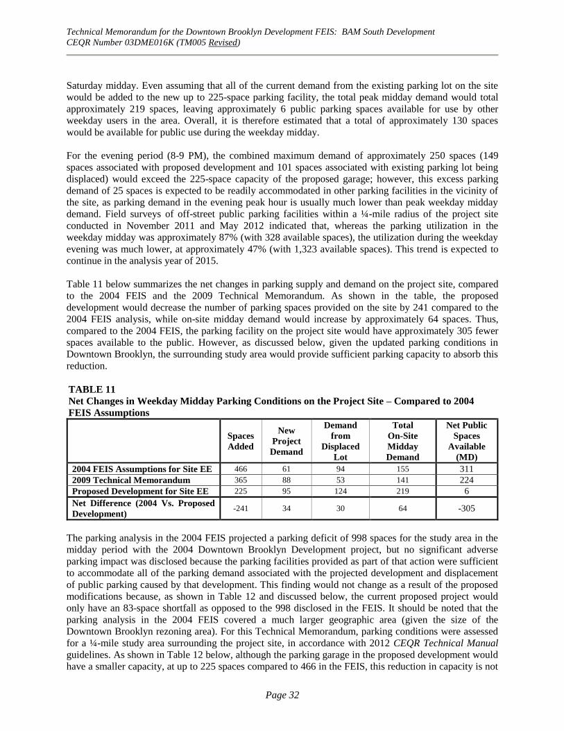
Technical Memorandum for the Downtown Brooklyn Development FEIS: BAM South Development
CEQR Number 03DME016K (TM005 Revised)
Page 32
Saturday midday. Even assuming that all of the current demand from the existing parking lot on the site
would be added to the new up to 225-space parking facility, the total peak midday demand would total
approximately 219 spaces, leaving approximately 6 public parking spaces available for use by other
weekday users in the area. Overall, it is therefore estimated that a total of approximately 130 spaces
would be available for public use during the weekday midday.
For the evening period (8-9 PM), the combined maximum demand of approximately 250 spaces (149
spaces associated with proposed development and 101 spaces associated with existing parking lot being
displaced) would exceed the 225-space capacity of the proposed garage; however, this excess parking
demand of 25 spaces is expected to be readily accommodated in other parking facilities in the vicinity of
the site, as parking demand in the evening peak hour is usually much lower than peak weekday midday
demand. Field surveys of off-street public parking facilities within a ¼-mile radius of the project site
conducted in November 2011 and May 2012 indicated that, whereas the parking utilization in the
weekday midday was approximately 87% (with 328 available spaces), the utilization during the weekday
evening was much lower, at approximately 47% (with 1,323 available spaces). This trend is expected to
continue in the analysis year of 2015.
Table 11 below summarizes the net changes in parking supply and demand on the project site, compared
to the 2004 FEIS and the 2009 Technical Memorandum. As shown in the table, the proposed
development would decrease the number of parking spaces provided on the site by 241 compared to the
2004 FEIS analysis, while on-site midday demand would increase by approximately 64 spaces. Thus,
compared to the 2004 FEIS, the parking facility on the project site would have approximately 305 fewer
spaces available to the public. However, as discussed below, given the updated parking conditions in
Downtown Brooklyn, the surrounding study area would provide sufficient parking capacity to absorb this
reduction.
TABLE 11
Net Changes in Weekday Midday Parking Conditions on the Project Site – Compared to 2004
FEIS Assumptions
Spaces
Added
New
Project
Demand
Demand
from
Displaced
Lot
Total
On-Site
Midday
Demand
Net Public
Spaces
Available
(MD)
2004 FEIS Assumptions for Site EE 466 61 94 155 311
2009 Technical Memorandum 365 88 53 141 224
Proposed Development for Site EE 225 95 124 219 6
Net Difference (2004 Vs. Proposed
Development) -241 34 30 64 -305
The parking analysis in the 2004 FEIS projected a parking deficit of 998 spaces for the study area in the
midday period with the 2004 Downtown Brooklyn Development project, but no significant adverse
parking impact was disclosed because the parking facilities provided as part of that action were sufficient
to accommodate all of the parking demand associated with the projected development and displacement
of public parking caused by that development. This finding would not change as a result of the proposed
modifications because, as shown in Table 12 and discussed below, the current proposed project would
only have an 83-space shortfall as opposed to the 998 disclosed in the FEIS. It should be noted that the
parking analysis in the 2004 FEIS covered a much larger geographic area (given the size of the
Downtown Brooklyn rezoning area). For this Technical Memorandum, parking conditions were assessed
for a ¼-mile study area surrounding the project site, in accordance with 2012 CEQR Technical Manual
guidelines. As shown in Table 12 below, although the parking garage in the proposed development would
have a smaller capacity, at up to 225 spaces compared to 466 in the FEIS, this reduction in capacity is not

2012 Modification Technical Memorandum for BAM South Development Figure 9
Stationary Source Screening for Residential Development HVAC
approximately386,200 gsf
Approximate distance from proposedBAM South development’s mechanicalpenthouse to closest point of theWilliamsburgh Savings Bank Building.
192’

approximately348,810 gsf
192’ Approximate distance from proposedBAM South development’s mechanicalpenthouse to closest point of theWilliamsburgh Savings Bank Building.
2012 Modification Technical Memorandum for BAM South Development Figure 10
Stationary Source Screening for Non-Residential Development HVAC

Technical Memorandum for the Downtown Brooklyn Development FEIS: BAM South Development
CEQR Number 03DME016K (TM005 Revised)
Page 33
expected to result in any significant adverse parking impacts in the quarter-mile area around the project
site. As shown in Table 12, the proposed development is estimated to result in a 2015 With-Action
parking deficit of 83 spaces within the quarter-mile study area in the midday period, which would be
essentially the same as 2015 conditions in absence of the proposed development.
As the proposed action would result in a parking deficit in the weekday midday smaller than that
projected in the 2004 FEIS, the proposed modifications would not result in any significant adverse
parking impacts, and the findings of both the 2004 FEIS relative to off-street parking would not change
due to the reconfigured garage on the project site.
TABLE 12
2015 Study Area Weekday Midday (12-1 PM) Off-Street Parking Conditions – Compared to 2004 FEIS
Total Study
Area Capacity
Total Study
Area Demand
Net Public Spaces
Available in Study Area
Downtown Brooklyn Development 2004 FEIS Parking Study Area
2004 FEIS – 2013 No-Action Conditions 10,839 12,018 -1,179
2004 FEIS – 2013 With-Action Conditions 11,275 12,273 -998
Quarter-Mile Study Area Around BAM South Site
2012 Existing Conditions (1) 2,474 2,146 328
2015 No-Action Condition (2) 2,354 2,443 - 89
Net Effect of Project Site Changes 101 95 ----
2015 Conditions with Proposed Development 2,455 2,538 - 83
(1) Based on PHA field surveys, November 2011 and May 2012. (2) No-Action capacity accounts for future No-Action spaces expected to be displaced on both BAM North Sites (a total of 120
spaces). No-Action demand includes existing demand plus background growth (assumed at 0.25 percent per year for 2013-
2015) and weekday midday demand from other expected developments in the study area, including Atlantic Yards
(Barclays Arena, buildings 1 and 2), the BAM cultural center, and other development projects in the ¼-mile study area
expected to be complete by 2015).
Transit and Pedestrians
The 2004 FEIS determined that the Downtown Brooklyn Development project would result in the
potential for significant adverse impacts at two street stairs at the Jay Street-Borough Hall subway station
in one or both peak periods, as well as a significant adverse impact in the PM peak hour to NYC Transit’s
B25 bus route in the peak eastbound direction. Pedestrian trips en route to and from projected
development sites would impact one crosswalk on Jay Street at Willoughby Street and one crosswalk on
Albee Square West/Gold Street at Willoughby Street. None of the impacted subway stair or pedestrian
facilities identified in the 2004 FEIS are located in the immediate vicinity of Site EE.
According to the general thresholds used by the Metropolitan Transportation Authority specified in the
CEQR Technical Manual, detailed transit analyses are not required if a proposed project is projected to
result in less than 200 peak hour rail or bus transit riders, because a proposed development that generates
such a low number of transit riders is unlikely to create a significant impact on the current transit
facilities.
As shown in Table 9 above, the proposed development is expected to generate a total of approximately
242, 209 and 350 subway trips during the AM, midday, and PM peak hours, respectively. When
compared to the subway trips estimated for Site EE in the 2004 FEIS (32, 326, and 261, respectively), the
proposed development would result in a net increase of 210 subway trips in the AM peak hour and 89

Technical Memorandum for the Downtown Brooklyn Development FEIS: BAM South Development
CEQR Number 03DME016K (TM005 Revised)
Page 34
subway trips in the PM peak hour, but a net decrease of 117 subway trips in the midday peak period.
Although the net increment in subway trips resulting from the proposed modifications would exceed 200
trips in the AM peak hour (compared to the 2004 project), it should be noted that the project site is
located in a transit-rich area with access to numerous subway lines, including the B, Q, 4, 5, D, N and R
subway lines at the nearest Subway station Atlantic Ave-Barclays Center-Pacific Street. As such, the net
increment in subway trips along any one of the subway lines would be less than the CEQR threshold of
200 trips in any peak hour. Therefore, no significant adverse impacts to subway transit are anticipated,
and no detailed analysis is necessary.
Similarly, as shown in Table 9 above, the proposed development is expected to generate a total of
approximately 20, 89 and 89 bus trips during the AM, midday, and PM peak hours, respectively. When
compared to the bus trips estimated for Site EE in the 2004 FEIS (9, 128, and 103, respectively), the
proposed development would result in a net increase of 11 bus trips in the AM peak hour, but a net
decrease of 39 and 14 bus trips in the midday and PM peak periods, respectively. As the net increments in
bus transit resulting from the proposed modifications (compared to the 2004 FEIS) fall well below the
threshold of 200 transit trips for a detailed transit analysis, they are not expected to result in any
significant adverse bus transit impacts, and no detailed analysis is necessary.
For pedestrian trips, the proposed development is expected to generate a total of approximately 168, 814
and 495 walk-only trips during the AM, midday, and PM peak hours, respectively (refer to Table 9).
When combined with subway and bus transit trips, the total pedestrian trips generated by the proposed
development would be 455, 1,082 and 931 trips during the AM, midday, and PM peak hours,
respectively. Compared to the total pedestrian trips (i.e., walk-only, subway and bus trips combined)
estimated for Site EE in the 2004 FEIS (119, 1,122, and 806, respectively), the proposed development
would result in a net increase of 336 pedestrian trips in the AM peak hour, a decrease of 40 pedestrian
trips in the midday, and an increase of 125 pedestrian trips in the PM peak period. As the net increments
in pedestrians resulting from the proposed modifications (compared to the 2004 FEIS) fall below the
threshold of 200 pedestrian trips for a detailed analysis in the midday and PM peak hours, they are not
expected to result in any significant adverse pedestrian impacts, and no detailed analysis is necessary.
Although the net increment of 336 in the AM peak hour would exceed the 200 trip threshold, as the
project site has three different street frontages, those trips would be distributed along a number of
sidewalks and corners/crosswalks. Therefore, no single pedestrian element in the vicinity of the project
site is expected to experience an incremental increase of more than 200 pedestrian trips in the AM peak
hour, and no significant adverse pedestrian impacts are anticipated.
As such, the proposed development on Site EE would not result in any new significant adverse impacts to
transit or pedestrian conditions, and the findings of the 2004 FEIS relative to transit and pedestrian
conditions would not change.
Air Quality
The 2004 FEIS screening analysis of air emissions due to heating, ventilation and air conditioning
(HVAC) equipment determined that there would be no significant adverse air quality impacts due to the
projected development on Site EE. A parking analysis was performed for the proposed public parking
garage on Site EE, which determined that no significant adverse air quality impacts would occur from
vehicles using the proposed garage.
Technical Memorandum for the Downtown Brooklyn Development FEIS: BAM South Development
CEQR Number 03DME016K (TM005 Revised)
Page 35
Mobile Sources
According to the 2012 CEQR Technical Manual screening threshold criteria for this area of the City, if a
project would generate 160 or more peak hour auto trips in the Downtown Brooklyn area of concern,
there is a potential for mobile source air quality impacts and a detailed analysis is required. As discussed
in the “Traffic and Parking” section above, there would be a maximum incremental increase of
approximately 25 vehicle trips in any peak hour compared to the Site EE program analyzed in the 2004
FEIS, which would be well below the 160 vehicle trips per hour CEQR threshold for a detailed mobile
source air quality analysis in Downtown Brooklyn. In addition, the garage vents associated with the
parking garage on-site would be located so as to avoid potential impacts on the residents of the proposed
development. Therefore, the proposed development would not result in any new significant adverse
mobile source air quality impacts, and would not alter the findings of the 2004 FEIS relative to mobile
source air quality.
Stationary Sources
The proposed development would have an overall height of approximately 382 feet, and would consist of
a total of approximately 348,810 zsf above grade. In accordance with CEQR guidelines, the stack height
for the emissions vent was estimated at three feet higher than the building height of 382 feet. Natural gas
is expected to be the heating source for the HVAC system. Impacts from boiler emissions are a function
of fuel type, stack height, minimum distance from the source to the nearest receptor (building), and floor
area (square footage) of development resulting from the project. If a screening analysis shows that the
nearest existing buildings to the proposed development that are of similar or greater height would not be
impacted by the new HVAC systems, then all other buildings in the vicinity would also not be impacted.
The only building of similar or greater height in the vicinity of the site is the approximately 512-foot tall
Williamsburg Savings Bank building, recently converted to residential use, which is located at a distance
of approximately 192 feet away from the proposed development’s boiler stack at the closest point (from
the center point of the illustrative mechanical bulkhead to the northwest corner of the Williamsburg
Savings Bank).
To determine if emissions from the proposed development would result in an adverse impact to this
building, a preliminary HVAC screening analysis was carried out using CEQR Technical Manual
methodologies. As the proposed mixed-use development is expected to use natural gas for HVAC
operations, Figures 17-7 and 17-8 from the 2012 CEQR Technical Manual Air Quality Appendix were
used (Figures 9 and 10). As shown in the figures, the HVAC emissions of the proposed development
would not cause an impact to the Williamsburg Savings Bank Building under either the residential or
commercial building thresholds/graphs. Therefore, no significant adverse air quality impacts associated
with HVAC systems would be anticipated as a result of the proposed development.
As discussed in the “Land Use and Zoning” section above, the area surrounding the project site is a mix
of commercial, retail, residential, and cultural uses. The proposed development would not be located
within 1,000 feet of a large emission source such as a power generating plant. It would also not be located
within 400 feet of manufacturing or processing facilities or a stack emission associated with commercial,
institutional, or large-scale residential development. In addition, the proposed development would not be
located near a medical, chemical, or research lab.
Therefore, the proposed development would not result in any new significant adverse stationary source air
quality impacts, and would not alter the findings of the 2004 FEIS relative to stationary source air quality.
However, it should be noted that the stationary source air quality assessment was performed for the

Technical Memorandum for the Downtown Brooklyn Development FEIS: BAM South Development
CEQR Number 03DME016K (TM005 Revised)
Page 36
current proposed design of the building. Should the design of the building change so that the location of
the stack release point changes, this issue may need to be re-examined.
Noise
Mobile Source Noise
As discussed in the “Traffic and Parking” section above, there would be a maximum incremental increase
of approximately 25 vehicle trips in any peak hour compared to the Site EE program analyzed in the 2004
FEIS. With such a small incremental increase in vehicular traffic, the proposed development would not
result in a doubling of PCE values in the study area, and would therefore not result in any new significant
adverse mobile source noise impacts. Therefore, the proposed modifications would not alter the findings
of the 2004 FEIS relative to mobile source noise.
Noise Attenuation
The 2004 FEIS concluded that an (E) designation would be placed on projected and potential
development sites in order to create a mechanism for providing sufficient building noise attenuation. Site
EE (Block 2110, Lot 3) was identified as requiring 35 dBA of window wall attenuation, and an (E)
designation is currently mapped on the site.
As the noise measurements presented in the 2004 FEIS were taken in 2003, more recent noise monitoring
data were researched in the vicinity of the project site in order to determine whether ambient noise levels
adjacent to the site have increased to a degree that would warrant additional attenuation. The Atlantic
Yards Arena and Redevelopment Project Final EIS (November 2006) identified and measured ambient
noise levels in the vicinity of the project site, along 4th Avenue between Atlantic Avenue and Pacific
Street (noise measurements made in 2006). This receptor location is approximately two blocks to the
south of the project site, and is therefore assumed to be representative of noise conditions for the BAM
South site. Based on ambient noise levels in the vicinity of the project site, with exterior L10(1) noise levels
ranging from 75 to 80 dBA,2 the proposed development would require an attenuation of 35 dBA for
residential uses (commercial uses would require 5dBA less attenuation in order to achieve indoor noise
levels of 50 dBA).
This can be achieved by including standard double-glazed windows with good sealing properties, and
closed window condition with an alternate method of ventilation. In order to maintain a closed-window
condition, an alternate means of ventilation must also be provided. Alternate means of ventilation
includes, but is not limited to, central air conditioning or air conditioning sleeves containing air
conditioners or HUD approved fans. Such measures would provide a minimum of 35 dBA of indoor noise
attenuation, and would provide sufficient attenuation to satisfy CEQR requirements. Furthermore, this
level of attenuation would satisfy the (E) designation requirements of the 2004 FEIS.
In addition, the proposed building’s mechanical systems (i.e., heating, ventilation, and air conditioning)
would be designed to meet all applicable noise regulations and to avoid producing levels that would result
in any significant increase in ambient noise levels. Therefore, the proposed development on Site EE
would not result in any new significant adverse noise impacts, and would not alter the findings of the
2004 FEIS.
2 Noise levels based on Atlantic Yards Arena and Redevelopment Project FEIS; November 2006, as shown in Table
11 of the July 14, 2008 Technical Memorandum.
Technical Memorandum for the Downtown Brooklyn Development FEIS: BAM South Development
CEQR Number 03DME016K (TM005 Revised)
Page 37
Public Health
The 2004 FEIS did not provide an analysis of public health, as the 2004 project did not meet any of the
thresholds warranting a public health assessment according to the guidelines of the CEQR Technical
Manual. The proposed development on Site EE would not alter these conditions, as no significant new air
quality, hazardous materials, or noise impacts have been identified, and no changes to anticipated solid
waste management practices would occur. Therefore, a public health analysis is not required.
Neighborhood Character
The 2004 FEIS did not identify any significant adverse neighborhood character impacts associated with
the Downtown Brooklyn Development project. The analysis noted that the neighborhood character in the
Fulton Street/Flatbush Avenue subarea, which encompasses Site EE, was not likely to change
significantly as a result of the Downtown Brooklyn Development project. The cultural uses that were
envisioned for this area were determined to be in keeping with existing land uses, and would further
enhance the area’s identity as a center of arts and entertainment, and provide for a smoother transition
between the residential neighborhoods to the east and south and the commercial activity to the north.
The proposed development would similarly enhance the neighborhood character of this area. The
proposed residential, commercial, and cultural uses would not conflict with surrounding land uses. The
proposed development would be part of an ongoing trend that is shaping a new mixed-use neighborhood
in this area at the southeastern edge of Downtown Brooklyn, and would contribute to and support the
continued growth of the neighborhood. As noted in the applicable sections of this technical memorandum,
no significant adverse impacts are likely to occur to open space, community facilities, traffic and
transportation, noise or air quality as a result of the proposed development. Therefore, no significant
adverse impacts to neighborhood character are expected, and the findings of the 2004 FEIS relative to
neighborhood character would not change.
Construction
Similar to other developments in the City, construction of the proposed development would result in
temporary disruption to the surrounding area, including some noise, and traffic associated with the
delivery of materials, construction machinery, and arrival of workers on the site. As the construction
period is expected to last approximately 24 months, it is considered a short-term construction project (as
per the CEQR definition), and does not require a detailed assessment. Given the relatively small size of
the project, it would not result in a significant amount of construction related traffic or mobile source
emissions from construction vehicles. Additionally, construction would be subject to compliance with the
New York City Noise Code.
As noted above, given its proximity to the Williamsburg Savings Bank building and the BAM historic
district, the proposed development would require a construction protection plan in order to avoid potential
physical impacts to these resources from ground-borne vibrations or other potential construction-related
issues. The City has procedures for avoidance of damage to historic structures from adjacent construction.
Building Code section 27-166 (C26-112.4) serves to protect historic structures by requiring that all lots,
buildings, and service facilities adjacent to foundation and earthwork areas be protected and supported in
accordance with the requirements of Building Construction Subchapter 7 (Article) and Building Code
Subchapters 11 and 19 (Article). In addition, the New York City Department of Buildings’ Technical
Policy and Procedure Notice (PPN) #10/88, supplements these procedures by requiring a monitoring
program to reduce the likelihood of construction damages to adjacent historic structures and to detect at
an early stage the beginnings of damage so that construction procedures can be changed.

Technical Memorandum for the Downtown Brooklyn Development FEIS: BAM South Development
CEQR Number 03DME016K (TM005 Revised)
Page 38
In addition, further hazardous materials investigation and/or remediation would be performed on Site EE
prior to development.
Therefore, there would be no new construction-period impacts in the area surrounding Site EE as a result
of the proposed modifications.
IV. CONCLUSION
The 2012 changes to the proposed program for development on Site EE would not result in any
significant adverse environmental impacts that had not been previously identified in either the 2004 FEIS
or the 2009 Technical Memorandum. Therefore, no additional analysis or supplemental environmental
impact statement is warranted for the proposed changes to the project described herein.
______________________ April 15, 2013
Robert R. Kulikowski, Ph.D. Date
Assistant to the Mayor