technical implementation program for natural resource ...lakeerie.ohio.gov/portals/0/closed...
TRANSCRIPT

Chagrin River Watershed Partners, Inc. LEPF 01-11
1
FINAL REPORT LAKE ERIE PROTECTION FUND 01-11
TECHNICAL IMPLEMENTATION PROGRAM FOR NATURAL RESOURCE PROTECTION IN THE CHAGRIN RIVER WATERSHED
December 31, 2003 The Organization The Chagrin River Watershed Partners, Inc. (CRWP) is a non-profit educational and technical organization formed in 1996 by watershed communities in response to increasing community costs from flooding, erosion, and water quality problems. Today CRWP represents 31 townships, counties, cities, and park districts or approximately 86% of the Chagrin River watershed. CRWP’s professional staff works directly with elected officials and their engineers, planners, law directors, and other professional advisors to implement innovative solutions to minimize the impacts of development as member communities continue to grow. The Project CRWP’s project with the Lake Erie Protection Fund supported CRWP’s work with members to update comprehensive plans, ordinances and resolutions, and other programs guiding land development, as well as to successfully compete for grant funds for land preservation and implementation of community specific projects. The Accomplishments In 2002 and 2003, CRWP’s professional staff spent a total of 2,929 hours working directly with members and their professional advisors under the Technical Implementation Program for Natural Resource Protection in the Chagrin River Watershed. The results of this work are summarized in Tables 1 and 2. Table 1 details CRWP services working directly with members for natural resource protection. These services include adoption and implementation of model regulations, direct landowner assistance, and work with members to successfully apply for funding for innovative storm water management projects.
CRWP Members Auburn Township Lake MetroParks City of Aurora City of Mayfield Heights Bainbridge Township Mayfield Village Village of Bentleyville Village of Moreland Hills Village of Chagrin Falls Munson Township Chagrin Falls Township Newbury Township Chester Township Orange Village Cleveland Metroparks City of Pepper Pike City of Eastlake Russell Township Village of Gates Mills City of Solon Geauga Park District Village of South Russell Village of Hunting Valley Waite Hill Village City of Kirtland City of Wickliffe Village of Kirtland Hills City of Willoughby Lake County City of Willoughby Hills Village of Woodmere

Chagrin River Watershed Partners, Inc. LEPF 01-11
2
Table 1: Member Specific Technical Support Member Project Summary Products City of Aurora Providing implementation support to the
City on application of their riparian and wetland setback zoning requirements
Bainbridge Township
Working with the Bainbridge Township Zoning Commission to tailor CRWP model Riparian Setback Resolution to the Township.
Riparian Setback Resolution passed unanimously by the Zoning Commission and awaiting Trustee approval. December 2003. Copy attached.
Geauga County Worked with the Geauga County Planning Commission, Soil and Water Conservation District (SWCD), and Prosecutor’s Office to develop Riparian Setback Model Resolution suitable to township legal authorities. Worked with these parties to also develop an Erosion, Sediment, and Storm Water Control Model Resolution.
Riparian Setback Model Resolution and Erosion, Sediment, and Storm Water Control Model Resolution approved by Geauga County Planning Commission. December 2003. Copy attached.
City of Kirtland Worked with City engineer, planner, law director, and Planning Commission, as well as the Lake County SWCD, to adopt riparian setback zoning and improved erosion and sediment control. Providing implementation support for application of the riparian setback requirements.
City of Kirtland Zoning Code Chapter 1294 establishing Riparian Setbacks and Building Code Chapter 1464 requiring Erosion and Sediment Control. June 2002. Copy attached.
Russell Township
Working with the Russell Township Zoning Commission to tailor CRWP model Erosion, Sediment, and Storm Water Management Resolution to the Township.
Erosion, Sediment, and Storm Water Management Resolution under consideration by the Zoning Commission. December 2003. Copy attached.
City of Willoughby Hills
Working with the City engineer, law director, and Council, as well as the Lake County SWCD, to adopt improved erosion and sediment control requirements.
Erosion and Sediment Control Ordinance under consideration by Council. December 2003. Copy attached.
Villages of Moreland Hills and Bentleyville, Township of Bainbridge
Prepared riparian setback maps for these communities as they consider adopting riparian setback ordinances.
Riparian Setback Maps. April and October 2003.

Chagrin River Watershed Partners, Inc. LEPF 01-11
3
Member Project Summary Products Cities of Aurora, Kirtland, and Solon, Townships of Chagrin Falls, Munson, and Russell, Village of Hunting Valley
Provided direct assistance to residents and their engineers experiencing significant and on-going erosion and flooding problems. Worked with residents/engineers to implement bioengineering and other alternative approaches to flooding and erosion control.
City of Willoughby Hills and Village of Chagrin Falls
Working with member engineers and affected residents to develop innovative solutions to persistent flooding and erosion problems impacting multiple landowners.
Cities of Willoughby Hills and Mayfield Heights, Village of Moreland Hills
Working with communities as they complete their Comprehensive Plans. Providing information on floodplains, wetlands, hillsides, and other natural resources and model zoning codes.
Completed Comprehensive Plan for Willoughby Hills and draft Plans for Moreland Hills and Mayfield Heights. April and December 2003.
Cities of Aurora and Eastlake, Townships of Munson and Russell
Working with these communities to obtain funding for land preservation and innovative storm water management projects.
$250,860 for floodplain preservation in City of Eastlake. December 2002 $120,000 for wetland preservation in Munson Township. October 2003 $250,000 for headwater stream preservation in Russell Township. October 2003 $32,000 for watershed study of storm water management solutions in built-out watershed in the City of Aurora. October 2003.
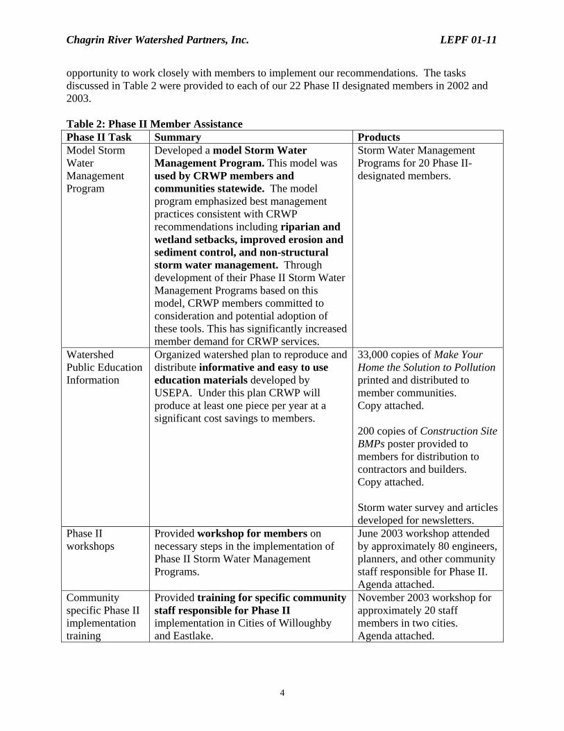
Table 2 details CRWP work with members under Ohio EPA’s NPDES Phase II Storm Water Management requirements. By March 2003, twenty-two (22) CRWP member communities submitted Storm Water Management Programs in compliance with Ohio EPA’s Phase II regulations. As discussed in our Interim Report, the best management practices recommended by Ohio EPA to meet the Phase II requirements are consistent with our recommendations to minimize the impacts of development and to maintain the functions of floodplains, wetlands, and open spaces as communities grow. As a result, Phase II provided CRWP with a unique
Chagrin River Watershed Partners, Inc. LEPF 01-11
4
opportunity to work closely with members to implement our recommendations. The tasks discussed in Table 2 were provided to each of our 22 Phase II designated members in 2002 and 2003. Table 2: Phase II Member Assistance Phase II Task Summary Products Model Storm Water Management Program
Developed a model Storm Water Management Program. This model was used by CRWP members and communities statewide. The model program emphasized best management practices consistent with CRWP recommendations including riparian and wetland setbacks, improved erosion and sediment control, and non-structural storm water management. Through development of their Phase II Storm Water Management Programs based on this model, CRWP members committed to consideration and potential adoption of these tools. This has significantly increased member demand for CRWP services.
Storm Water Management Programs for 20 Phase II-designated members.
Watershed Public Education Information
Organized watershed plan to reproduce and distribute informative and easy to use education materials developed by USEPA. Under this plan CRWP will produce at least one piece per year at a significant cost savings to members.
33,000 copies of Make Your Home the Solution to Pollution printed and distributed to member communities. Copy attached. 200 copies of Construction Site BMPs poster provided to members for distribution to contractors and builders. Copy attached. Storm water survey and articles developed for newsletters.
Phase II workshops
Provided workshop for members on necessary steps in the implementation of Phase II Storm Water Management Programs.
June 2003 workshop attended by approximately 80 engineers, planners, and other community staff responsible for Phase II. Agenda attached.
Community specific Phase II implementation training
Provided training for specific community staff responsible for Phase II implementation in Cities of Willoughby and Eastlake.
November 2003 workshop for approximately 20 staff members in two cities. Agenda attached.

Chagrin River Watershed Partners, Inc. LEPF 01-11
5
Next Steps The expected results of this Project, as detailed in our application, included:
Heightened awareness among targeted groups of water quality and quantity problems, causes, and solutions, and a willingness to take action.
Adoption of alternative land use and site development practices to reduce impervious
cover and reliance on structural approaches to manage storm water.
Voluntary and regulatory riparian and wetland protection and adoption of upgraded erosion control, storm water, and floodplain management regulations.
Through our work with members in 2002 and 2003 we saw these results. As highlighted in Tables 1 and 2, our accomplishments under this Project educated elected officials and their professional advisors about the need for long-term natural resource management and effectively provided these decision makers with the tools necessary to implement such management. Our work assisting members to minimize the impacts of land use change continues after the completion of the Technical Implementation Program for Natural Resource Protection in the Chagrin River Watershed. Our activities in 2004 include:
Supporting members through direct, one-on-one assistance as they implement riparian and wetland setbacks, improved erosion and sediment control, and non-structural storm water management.
Conducting a Site Planning Roundtable to increase the understanding and use of our
recommendations in Northeast Ohio and to expand the use of decentralized storm water management techniques such as bioretention and rain gardens.
Helping members develop and fund innovative solutions to chronic flooding and erosion
problems.
Educating members and interested residents about the services provided by natural resources and the impacts of development on the long-term viability of these services.
Continuing our watershed studies including inventorying headwater streams, locating
available wetland and stream mitigation sites; and developing watershed specific impervious cover information. These studies expand our understanding of the Chagrin River watershed and provide the technical support necessary for members as they adopt our recommended model ordinances and resolutions.
As highlighted in our application for this Project, our work specifically under the Technical Implementation Program for Natural Resource Protection in the Chagrin River Watershed, as well as our 2004 planned activities, are consistent with the Ohio Lake Erie Commission’s Ten Guiding Principles for a Sustainable Lake Erie Watershed detailed in the Lake Erie Protection
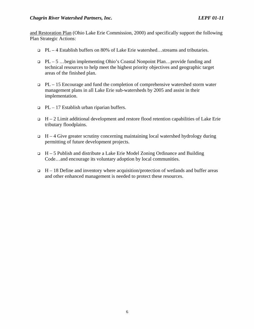
Chagrin River Watershed Partners, Inc. LEPF 01-11
6
and Restoration Plan (Ohio Lake Erie Commission, 2000) and specifically support the following Plan Strategic Actions:
PL – 4 Establish buffers on 80% of Lake Erie watershed…streams and tributaries.
PL – 5 …begin implementing Ohio’s Coastal Nonpoint Plan…provide funding and technical resources to help meet the highest priority objectives and geographic target areas of the finished plan.
PL – 15 Encourage and fund the completion of comprehensive watershed storm water
management plans in all Lake Erie sub-watersheds by 2005 and assist in their implementation.
PL – 17 Establish urban riparian buffers.
H – 2 Limit additional development and restore flood retention capabilities of Lake Erie
tributary floodplains.
H – 4 Give greater scrutiny concerning maintaining local watershed hydrology during permitting of future development projects.
H – 5 Publish and distribute a Lake Erie Model Zoning Ordinance and Building
Code…and encourage its voluntary adoption by local communities.
H – 18 Define and inventory where acquisition/protection of wetlands and buffer areas and other enhanced management is needed to protect these resources.
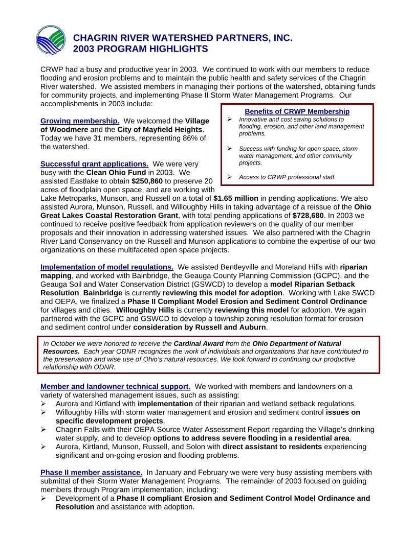
CHAGRIN RIVER WATERSHED PARTNERS, INC. 2003 PROGRAM HIGHLIGHTS
CRWP had a busy and productive year in 2003. We continued to work with our members to reduce flooding and erosion problems and to maintain the public health and safety services of the Chagrin River watershed. We assisted members in managing their portions of the watershed, obtaining funds for community projects, and implementing Phase II Storm Water Management Programs. Our accomplishments in 2003 include: Growing membership. We welcomed the Village of Woodmere and the City of Mayfield Heights. Today we have 31 members, representing 86% of the watershed. Successful grant applications. We were very busy with the Clean Ohio Fund in 2003. We assisted Eastlake to obtain $250,860 to preserve 20 acres of floodplain open space, and are working with Lake Metroparks, Munson, and Russell on a total of $1.65 million in pending applications. We also assisted Aurora, Munson, Russell, and Willoughby Hills in taking advantage of a reissue of the Ohio Great Lakes Coastal Restoration Grant, with total pending applications of $728,680. In 2003 we continued to receive positive feedback from application reviewers on the quality of our member proposals and their innovation in addressing watershed issues. We also partnered with the Chagrin River Land Conservancy on the Russell and Munson applications to combine the expertise of our two organizations on these multifaceted open space projects. Implementation of model regulations. We assisted Bentleyville and Moreland Hills with riparian mapping, and worked with Bainbridge, the Geauga County Planning Commission (GCPC), and the Geauga Soil and Water Conservation District (GSWCD) to develop a model Riparian Setback Resolution. Bainbridge is currently reviewing this model for adoption. Working with Lake SWCD and OEPA, we finalized a Phase II Compliant Model Erosion and Sediment Control Ordinance for villages and cities. Willoughby Hills is currently reviewing this model for adoption. We again partnered with the GCPC and GSWCD to develop a township zoning resolution format for erosion and sediment control under consideration by Russell and Auburn.
Member and landowner technical support. We worked with members and landowners on a variety of watershed management issues, such as assisting:
Aurora and Kirtland with implementation of their riparian and wetland setback regulations. Willoughby Hills with storm water management and erosion and sediment control issues on
specific development projects. Chagrin Falls with their OEPA Source Water Assessment Report regarding the Village’s drinking
water supply, and to develop options to address severe flooding in a residential area. Aurora, Kirtland, Munson, Russell, and Solon with direct assistant to residents experiencing
significant and on-going erosion and flooding problems.
Phase II member assistance. In January and February we were very busy assisting members with submittal of their Storm Water Management Programs. The remainder of 2003 focused on guiding members through Program implementation, including:
Development of a Phase II compliant Erosion and Sediment Control Model Ordinance and Resolution and assistance with adoption.
In October we were honored to receive the Cardinal Award from the Ohio Department of Natural Resources. Each year ODNR recognizes the work of individuals and organizations that have contributed to the preservation and wise use of Ohio’s natural resources. We look forward to continuing our productive relationship with ODNR.
Benefits of CRWP Membership Innovative and cost saving solutions to
flooding, erosion, and other land management problems.
Success with funding for open space, storm
water management, and other community projects.
Access to CRWP professional staff.

Organization of a watershed public education information strategy and printing of the USEPA brochure Make Your Home the Solution to Pollution for members at a reduced price.
Working with the Geauga County Engineer, SWCD, Health District, and Bainbridge and Russell to develop an illicit discharge detection and elimination protocol for the County.
Assisting Auburn to successfully obtain a waiver from the Phase II requirements. Working with Lake SWCD and CT Consultants to train Willoughby and Eastlake service,
building, and other staff on Phase II implementation including illicit discharge detection and elimination protocols, erosion and sediment control inspection, municipal pollution prevention activities, and recordkeeping and reporting.
Statewide leadership. We continued to be recognized as a leader in watershed management. We made presentations at state and national conferences and represented the watershed on the Lake Erie Commission’s Balanced Growth Initiative and other statewide committees impacting members. Watershed projects. Through these projects we gather information to support member land management activities and implementation of our recommended model regulations. These projects also increase landowner awareness about watershed management. Our projects include:
Controlling Stream Bank Erosion: We installed three tree revetments in Eastlake and Russell to reduce stream bank erosion and minimize downstream flow of logs and other woody debris. We hosted four site tours of the projects and are drafting a pamphlet on the technique.
Inventorying Headwater Streams: We
surveyed 60 streams in the Upper Main Branch in Chester, Munson, Newbury, and Russell. This project also involved significant landowner contact and has lead to several other projects to address specific erosion and flooding concerns.
Maintaining Wetland and Stream Function: We surveyed potential mitigation sites to assist
members in ensuring that the flood control, erosion control, and water quality protection services of wetlands and streams are not removed from the watershed when land is developed.
Gulley Brook Watershed Study: We coordinated with Wickliffe, Willoughby, Willoughby Hills,
Lake Metroparks, and Lake SWCD to assist the U.S. Army Corps of Engineers in studying potential restoration projects in the Gulley Brook drainage. Through this study we increased the Corps understanding of the sophistication of watershed planning in the Chagrin and explored several other Corps funding opportunities to address member concerns.
For More Information Contact Kyle Dreyfuss-Wells, Executive Director
440-975-3870 [email protected]
CRWP Members: Auburn, Aurora, Bainbridge, Bentleyville, Chagrin Falls, Chagrin Falls Twp., Chester, Cleveland Metroparks, Eastlake, Gates Mills, Geauga Park District, Hunting Valley, Kirtland, Kirtland Hills, Lake County, Lake MetroParks, Mayfield Heights, Mayfield Village, Moreland Hills, Munson, Newbury, Orange, Pepper Pike, Russell, Solon, South Russell, Waite Hill, Wickliffe, Willoughby, Willoughby Hills, and Woodmere.
Watch for in 2004 WRRSP Nominations: OEPA’s WRRSP
program is a great source of funding for open space acquisition. In 2003 we assisted Kirtland in nominating projects in association with their planned sewer extension. This will assist Holden Arboretum and Aurora with preservation and will provide Kirtland with interest savings on their loan. Please contact CRWP if you have open space goals or are undertaking a sewer project.
Chagrin Total Maximum Daily Load Study: In
2004 OEPA will sample the watershed. This will identify major sources of pollution, such as sediment. CRWP is working with OEPA to ensure the study is conducted for maximum member benefit.
Phase II Implementation: Please check your
Storm Water Management Program for those activities you planned for 2004 such as implementation of an illicit discharge detection regulation and riparian setbacks. CRWP is available to assist with these activities.
District 1 Clean Ohio Fund: Applications for
District 1 will be due in March 2004. Begin today to identify projects and we will work with you to ensure high quality applications.

Chagrin River Watershed Partners, Inc. December 2003 Draft Riparian Setback Resolution for Bainbridge Township
1
Chapter 160 ESTABLISHMENT OF RIPARIAN SETBACKS
160.01: PUBLIC PURPOSE (a) The specific purpose and intent of this regulation is to regulate building and land use
within riparian setback areas that would impair the ability of these areas to:
(1) Reduce flood impacts by absorbing peak flows, slowing the velocity of floodwaters, and regulating base flow.
(2) Assist in stabilizing the banks of watercourses to reduce woody debris from fallen
or damaged trees, stream bank erosion, and the downstream transport of sediments eroded from watercourse banks.
(3) Reduce pollutants in watercourses during periods of high flows by filtering,
settling, and transforming pollutants already present in watercourses.
(4) Reduce pollutants in watercourses by filtering, settling, and transforming pollutants in runoff before they enter watercourses.
(5) Provide watercourse habitats with shade and food.
(6) Reduce the presence of aquatic nuisance species to maintain a diverse aquatic
system.
(7) Provide riparian habitat to a wide array of wildlife by maintaining diverse and connected riparian vegetation.
(b) This regulation has been enacted to protect these services of riparian areas by providing
reasonable controls governing building and land use within a riparian setback along designated watercourses in Bainbridge.
(c) This regulation has been enacted in compliance with Bainbridge Township Phase II
Storm Water Management Program, adopted February 24, 2003, as required by 40 C.F.R. Parts 9, 122, 123, and 124.
160.02: APPLICABILITY (a) This regulation shall apply to all zoning districts in Bainbridge as defined in the most
recent version of the Bainbridge Township Zoning Resolution. (b) This regulation shall apply to all lands that are within the jurisdiction of Bainbridge and

Chagrin River Watershed Partners, Inc. December 2003 Draft Riparian Setback Resolution for Bainbridge Township
2
that border designated watercourses as defined in this regulation. 160.03: DEFINITIONS For the purpose of this regulation, the following terms shall have the meaning herein indicated: (a) “Bainbridge” means Bainbridge Township, its designated representatives, boards, or
commission. (b) “Damaged or Diseased Trees” means trees that have split trunks; broken tops; heart rot;
insect or fungus problems that will lead to imminent death; undercut root systems that put the tree in imminent danger of falling; lean as a result of root failure that puts the tree in imminent danger of falling; or any other condition that puts the tree in imminent danger of being uprooted or falling into or along a watercourse or on to a structure.
(c) “Designated Watercourse” means a watercourse that is contained within, flows through,
or borders Bainbridge and meets the criteria set forth in Section 160.05 of this regulation. (d) “Federal Emergency Management Agency (FEMA)” means the agency with overall
responsibility for administering the National Flood Insurance Program. (e) “100-Year Floodplain” means any land susceptible to being inundated by water from a
base flood. The base flood is the flood that has a one percent or greater chance of being equaled or exceeded in any given year. The 100-Year Floodplain shall be defined by the Federal Emergency Management Agency maps for Bainbridge Township.
(f) “Ohio Environmental Protection Agency” means the organization referred throughout
this regulation as the "Ohio EPA." (g) “Ordinary High Water Mark” means the point of the bank to which the presence and
action of surface water is so continuous as to leave an area marked by erosion, destruction, or prevention of woody terrestrial vegetation, predominance of aquatic vegetation, or other easily recognized characteristic. The ordinary high water mark defines the bed of a watercourse.
(h) “Riparian Area” means naturally vegetated land adjacent to watercourses that, if
appropriately sized, helps to stabilize streambanks, limit erosion, reduce flood size flows, and/or filter and settle out runoff pollutants, or performs other functions consistent with the purposes of this regulation.
(i) “Riparian Setback” means those lands in Bainbridge that fall within the area defined by
the criteria set forth in Section 160.05 of this regulation. (j) “Soil and Water Conservation District” means an entity organized under Chapter 1515 of

Chagrin River Watershed Partners, Inc. December 2003 Draft Riparian Setback Resolution for Bainbridge Township
3
the Ohio Revised Code referring to either the Soil and Water Conservation District Board or its designated employees.
(k) “Soil Disturbing Activity” means clearing, grading, excavating, filling, dumping, cutting,
grubbing, stripping, or other alteration of the earth’s surface where natural or human made ground cover is destroyed and which may result in, or contribute to, erosion and sediment pollution.
(l) “Waste Water Treatment Plant (WWTP)” means a facility at the end of a sanitary
collection system, which processes the influent waste and discharges water to a receiving stream treated to standards of the Ohio EPA.
(m) “Watercourse” means any brook, channel, creek, river, or stream having banks, a defined
bed, and definite direction of flow, either continuously or intermittently flowing. (n) “Wetland” means those areas that are inundated or saturated by surface or ground water
at a frequency and duration sufficient to support, and that under normal circumstances do support, a prevalence of vegetation typically adapted for life in saturated soil conditions, including swamps, marshes, bogs, and similar areas. (40 CFR 232, as amended).
160.04: ESTABLISHMENT OF DESIGNATED WATERCOURSES AND RIPARIAN SETBACKS (a) Designated watercourses shall include those watercourses meeting any ONE of the
following criteria: (1) All watercourses draining an area greater than or equal to ½ square mile, OR (2) All watercourses draining an area less than ½ square mile and having a defined
bed and bank. In determining if watercourses have a defined bed and bank, the Zoning Inspector may consult with representatives of the Geauga SWCD or other technical experts.
(b) Riparian setbacks on designated watercourses are established as follows:
(1) A minimum of 120 feet on each side of all watercourses draining an area greater than or equal to 20 square miles.
(2) A minimum of 75 feet on each side of all watercourses draining an area greater
than or equal to ½ square mile and up to 20 square miles.
(3) A minimum of 25 feet on each side of all watercourses draining an area less than ½ square mile and having a defined bed and bank as determined in Section 160.04(a)(2) of this regulation.

Chagrin River Watershed Partners, Inc. December 2003 Draft Riparian Setback Resolution for Bainbridge Township
4
(c) Riparian Setback Map. The Township shall create a map identifying designated
watercourses and their riparian setbacks. This map is attached with this regulation as Exhibit A. The following shall apply to the Riparian Setback Map:
(1) Nothing herein shall prevent the Township from making additions, amendments,
revisions, or deletions from the Riparian Setback Map.
(2) If any discrepancy is found at the time of application of this regulation between the Riparian Setback Map and the criteria for designated watercourses or riparian setbacks as set forth in 160.04 (a) and (b) of this regulation, 160.04 (a) and (b) shall prevail.
(d) The following shall apply in riparian setbacks:
(1) Riparian setbacks shall be measured in a horizontal direction outward from the ordinary high water mark of a designated watercourse.
(2) Except as otherwise provided in this regulation, riparian setbacks shall be
preserved in their natural state.
(3) Where the 100-year floodplain is wider than a riparian setback on either or both sides of a designated watercourse, the riparian setback shall be extended to the outer edge of the 100-year floodplain. The 100-year floodplain shall be defined by FEMA.
(4) Where wetlands are identified within a riparian setback, the minimum riparian
setback width shall be extended to the outer boundary of the wetland. Wetlands shall be delineated by a site survey prepared by a qualified wetlands professional using delineation protocols accepted by the U.S. Army Corps of Engineers and the Ohio EPA at the time of application of this regulation. If a conflict exists between the delineation protocols of these two agencies, the delineation protocol that results in the most inclusive area of wetland shall apply.
(e) The site owner shall be responsible for delineating riparian setbacks as required by these
regulations and shall identify these setbacks on all site plans submitted to the Zoning Inspector. The site plan shall be drawn to scale and shall be based upon a survey of the affected lot. Two (2) copies of the site plan shall be submitted with the application for a zoning certificate as required by the resolution. In addition, the site plan shall be submitted in an electronic format, either in Arc View GIS or AutoCAD.
(f) Prior to any soil disturbing activity, riparian setbacks shall be clearly delineated by the
site owner on site with construction fencing, and such delineation shall be maintained throughout soil disturbing activities.

Chagrin River Watershed Partners, Inc. December 2003 Draft Riparian Setback Resolution for Bainbridge Township
5
(g) The Zoning Inspector shall not issue approvals or permits prior to delineation of riparian
setbacks in conformance with this regulation. (h) The Zoning Inspector may consult with the Geauga SWCD, the Chagrin River Watershed
Partners, Inc., or other such experts retained by the board of township trustees in reviewing any submittals associated with implementation of this regulation.
160.05: PERMITTED STRUCTURES AND USES WITHOUT ZONING CERTIFICATE The following structures and uses are permitted in the riparian setback without a zoning certificate. No structure or use permitted under this regulation shall allow trespass on, or public access to, privately held lands. (a) Recreational Activity. Passive recreational uses, as permitted by Chapter 142 Passive
Public Park District. (b) Removal of Damaged or Diseased Trees: Damaged or diseased trees may be removed. (c) Maintenance and Repairs: Maintenance and repair on roads, driveways, bridges, culverts,
trails, walkways, paths, wastewater treatment plants and appurtenances, water wells, water treatment plants and appurtenances, storm sewers, and on-site sewage disposal systems, all existing at the time of passage of this resolution.
(d) Maintenance and Cultivation of Lawns and Landscaping: The maintenance of existing,
and the cultivation of new, lawns, landscaping, shrubbery, or trees. (e) Water Supply Wells: Water supply wells for the purpose of serving permitted structures
or uses on lots of record shall be allowed. 160.06: PERMITTED STRUCTURES AND USES WITH ZONING CERTIFICATE The following structures and uses may be permitted in a riparian setback, subject to the approval of an application for a zoning certificate by the Zoning Inspector and in accordance with the following regulations and such other applicable regulations contained in this zoning resolution. (a) Crossings: Crossings of designated watercourses through riparian setbacks with roads,
driveways, easements, bridges, culverts, or other means shall be allowed, subject to other requirements of the Bainbridge Township Zoning Resolution, the Geauga SWCD, and the Geauga County Engineer. If work will occur below the ordinary high water mark of the designated watercourse, proof of compliance with the applicable conditions of US Army Corps of Engineers Nationwide Permit 14, including the Ohio State Certification Special Conditions and Limitations, shall also be provided to the Zoning Inspector. Proof of compliance shall be the following:

Chagrin River Watershed Partners, Inc. December 2003 Draft Riparian Setback Resolution for Bainbridge Township
6
(1) A site plan showing that any proposed crossing conforms to the general and
specific conditions of Nationwide Permit 14, or (2) A copy of the authorization letter from the U.S. Army Corps of Engineers
approving activities under Nationwide Permit 14. (b) Streambank Stabilization Projects. Streambank stabilization projects along designated
watercourses shall be allowed, subject to other requirements of the Bainbridge Township Zoning Resolution and the Geauga SWCD. If streambank stabilization work is proposed below the ordinary high water mark of the designated watercourse, proof of compliance with the applicable conditions of US Army Corps of Engineers Nationwide Permit 13, including the Ohio State Certification Special Conditions and Limitations, shall be provided to the Zoning Inspector. Proof of compliance shall be the following:
(1) A site plan showing that any proposed crossing conforms to the general and
specific conditions of Nationwide Permit 13, or (2) A copy of the authorization letter from the U.S. Army Corps of Engineers
approving activities under Nationwide Permit 13. (c) Storm Water Retention and Detention Facilities: Storm water retention and detention
facilities may be constructed in the riparian setback, provided:
(1) Storm water quality treatment consistent with current Ohio EPA and Geauga County SWCD regulations is incorporated into the basin.
(2) Storm water retention and detention facilities are located at least 50 feet from the
ordinary high water mark of the designated watercourse. (d) Signs: Signs in accordance with this zoning resolution may be erected in the riparian
setback. 160.07: CONDITIONAL STRUCTURES AND USES IN RIPARIAN SETBACKS The following conditional structures and uses may be allowed in riparian setbacks, subject to the approval of an application for a conditional zoning certificate by the board of zoning appeals in accordance with the conditions herein and such other applicable regulations set forth in this zoning resolution. (a) Waste Water Treatment Plants and Appurtenances. Waste water treatment plants and
appurtenances may be constructed in the riparian setback. Proof of compliance with the applicable regulations of the Ohio EPA and the Geauga County Water Resources

Chagrin River Watershed Partners, Inc. December 2003 Draft Riparian Setback Resolution for Bainbridge Township
7
Department shall be provided. 160.08: STRUCTURES AND USES PROHIBITED IN RIPARIAN SETBACKS Any structure or use not permitted under this regulation shall be prohibited in riparian setbacks. The following structures or uses are specifically prohibited: (a) Construction. There shall be no structures, as defined in Chapter 105 of the Bainbridge
Township Zoning Resolution, of any kind except as permitted under this regulation. (b) Dredging or Dumping. There shall be no drilling, filling, dredging, or dumping of soil,
spoils, liquids, yard wastes, or solid materials, except for noncommercial composting of uncontaminated natural materials and except as permitted under this regulation.
(c) Fences and Walls: There shall be no fences or walls constructed in the riparian setback
except as permitted under this regulation. (d) Parking Spaces or Lots and Loading/Unloading Spaces for Vehicles: There shall be no
parking spaces, lots, or loading/unloading spaces, except as permitted under this regulation.
(e) Roads or Driveways. There shall be no roads or driveways, except as permitted under
this regulation. 160.09: INSPECTION OF RIPARIAN SETBACKS The delineation of riparian setbacks shall be inspected by the Zoning Inspector: (a) Prior to soil disturbing activities authorized by the Zoning Inspector under a subdivision,
land development plan, and/or zoning permit. The applicant shall provide the Zoning Inspector with at least two (2) working days notice prior to starting such soil disturbing activities.
(b) Prior to activities authorized by the Zoning Inspector under 160.05 (b) and (c) of this
regulation. The applicant shall provide the Zoning Inspector with at least two (2) working days notice prior to starting such activities.

Model Township Zoning Resolution XV-1
ARTICLE XV
ESTABLISHMENT OF RIPARIAN SETBACKS
Section 1500.0 Purpose and Intent A. The specific purpose and intent of these regulations is to regulate buildings, structures, and
uses within riparian setback areas that would impair the ability of these areas to:
1. Reduce flood impacts by absorbing peak flows, slowing the velocity of flood waters, and
regulating base flow. 2. Assist in stabilizing the banks of designated watercourses to reduce woody debris from
fallen or damaged trees, stream bank erosion, and the downstream transport of sediments eroded from such watercourse banks.
3. Reduce pollutants in designated watercourses during periods of high flows by filtering,
settling, and transforming pollutants already present in such watercourses.
4. Reduce pollutants in designated watercourses by filtering, settling, and transforming pollutants in runoff before they enter such watercourses.
5. Provide designated watercourse habitats with shade and food.
6. Reduce the presence of aquatic nuisance species to maintain a diverse aquatic system.
7. Provide riparian habitat with a wide array of wildlife by maintaining diverse and
connected riparian vegetation.
8. Minimize encroachment on designated watercourses and limiting the potential need for invasive measures that may otherwise be necessary to protect buildings, structures, and uses as well as to reduce the damage to real property and threats to public and safety within the affected watershed.
9. Preserve and conserve the quality and free flowing condition of designated watercourses
in the interest of promoting and protecting public health and safety.
Note: The township should also cite documentation in support of these regulations, available from the Geauga SWCD and the Chagrin River Watershed Partners, in its minutes during the zoning amendment process.
Note: This model was developed by the Geauga County Planning Commission, the Chagrin River Watershed Partners, Inc., and the Geauga Soil and Water Conservation District. Feel free to contact these organizations with questions regarding implementation.

Model Township Zoning Resolution XV-2
B. These regulations have been enacted to protect and enhance the functions of riparian areas
by providing reasonable controls governing buildings, structures, and uses within a riparian setback along designated watercourses in the township.
C. These regulations have been enacted in compliance with the __________ Township Phase II Storm Water Management Program, adopted ___________ ____, 2003, as required by 40 C.F.R. Parts 9, 122, 123, and 124.
Section 1501.0 Applicability A. These regulations shall apply to all zoning districts. B. The regulations set forth herein shall apply to all buildings, structures, and uses on a lot
containing a designated watercourse, except as otherwise provided herein. C. The use of any building, structure or lot lawfully existing prior to the effective date of these
regulations may be continued, subject to the provisions of Article IX, Nonconforming Buildings, Structures, and Uses.
D. The repair, maintenance, extension, replacement, restoration, reconstruction or substitution
of a building structure or use lawfully existing prior to the effective date of these regulations may be continued or completed, subject to the provisions of Article IX, Nonconforming Buildings, Structures, And Uses.
E. No zoning certificate or conditional zoning certificate shall be issued for any building,
structure or use on a lot containing, wholly or partly, a designated watercourse except in conformity with the regulations set forth herein.
Section 1502.0 Definitions For the purpose of these regulations, the following terms shall have the meanings as provided herein. A. “Damaged or Diseased Trees” means trees that have split trunks; broken tops; heart rot;
insect or fungus problems that will lead to imminent death; undercut root systems that put the tree in imminent danger of falling; lean as a result of root failure that puts the tree in imminent danger of falling; or any other condition that puts the tree in imminent danger of being uprooted or falling into or along a watercourse or on to building or structure.
B. “Designated Watercourse” means a river or stream within the township that is in
conformity with the criteria set forth in these regulations and is shown on the “riparian setback map” identified as exhibit “_____” attached hereto and made a part hereof.
C. “Federal Emergency Management Agency (FEMA)” means the agency with overall
Note: Paragraph “C” applies only to those townships within the EPA Phase II Storm Water Management Program.

Model Township Zoning Resolution XV-3
responsibility for administering the National Flood Insurance Program.
D. “Impervious cover” means any paved, hardened or structural surface regardless of its composition including (but not limited to) buildings, roads, driveways, parking lots, loading/unloading spaces, decks, patios, and swimming pools.
E. “Land Development Activity” means any change to the surface area of a lot including (but
not limited to) clearing, grubbing, stripping, removal of vegetation, dredging, grading, excavating, cut and fill, construction of buildings or structures, paving, and any other installation of impervious cover.
F. “Ohio Environmental Protection Agency” means the governmental agency referred to
herein as the Ohio EPA.
G. “One Hundred Year Floodplain” means any land susceptible to being inundated by water from a base flood. The base flood is the flood that has a one percent or greater chance of being equaled or exceeded in any given year. The one hundred year floodplain shall be defined by the Federal Emergency Management Agency maps of the township.
H. “Ordinary High Water Mark” means the point of the bank to which the presence and action
of surface water is so continuous as to leave an area marked by erosion, destruction or prevention of woody terrestrial vegetation, predominance of aquatic vegetation or other easily recognized characteristic. The ordinary high water mark defines the bed of a watercourse.
I. “Riparian Area” means naturally vegetated land adjacent to designated watercourses that,
if appropriately sized, helps to stabilize streambanks, limit erosion, reduce flood size flows and/or filter and settle out runoff pollutants or performs other functions consistent with the purposes of these regulations.
J. “Riparian Setback” means the real property adjacent to a designated watercourse located
within the area defined by the criteria set forth in these regulations.
K. “Soil and Water Conservation District (SWCD)” means the Geauga County, Ohio Soil and Water Conservation District, organized under Chapter 1515 of the Ohio Revised Code, including the Board of Supervisors and its designated employees.
L. “Soil Disturbing Activity” means clearing, grading, excavating, filling or other alteration of
the earth’s surface where natural or human made ground cover is destroyed and which may result in, or contribute to, erosion and sediment pollution.
M. “Waste Water Treatment Plant (WWTP)” means a facility at the end of sanitary collection
system, which processes the influent waste and discharges water to a receiving stream, treated to the standards of the Ohio EPA.
N. “Watercourse” means any brook, channel, creek, river, or stream having banks, a defined
bed, and definite direction of flow, either continuously or intermittently flowing.
O. “Wetland” means those areas that are inundated or saturated by surface or ground water at a frequency and duration sufficient to support, and that under normal circumstances do
Model Township Zoning Resolution XV-4
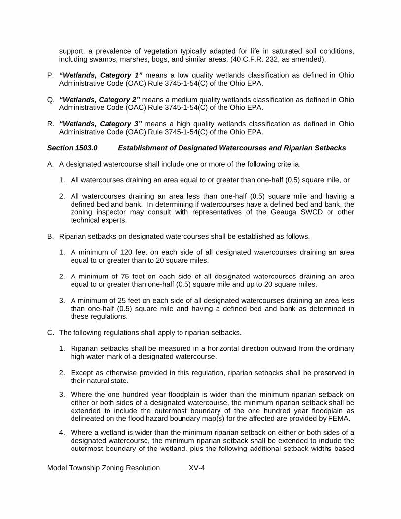
support, a prevalence of vegetation typically adapted for life in saturated soil conditions, including swamps, marshes, bogs, and similar areas. (40 C.F.R. 232, as amended).
P. “Wetlands, Category 1” means a low quality wetlands classification as defined in Ohio Administrative Code (OAC) Rule 3745-1-54(C) of the Ohio EPA.
Q. “Wetlands, Category 2” means a medium quality wetlands classification as defined in Ohio
Administrative Code (OAC) Rule 3745-1-54(C) of the Ohio EPA. R. “Wetlands, Category 3” means a high quality wetlands classification as defined in Ohio
Administrative Code (OAC) Rule 3745-1-54(C) of the Ohio EPA.
Section 1503.0 Establishment of Designated Watercourses and Riparian Setbacks A. A designated watercourse shall include one or more of the following criteria.
1. All watercourses draining an area equal to or greater than one-half (0.5) square mile, or 2. All watercourses draining an area less than one-half (0.5) square mile and having a
defined bed and bank. In determining if watercourses have a defined bed and bank, the zoning inspector may consult with representatives of the Geauga SWCD or other technical experts.
B. Riparian setbacks on designated watercourses shall be established as follows.
1. A minimum of 120 feet on each side of all designated watercourses draining an area
equal to or greater than to 20 square miles. 2. A minimum of 75 feet on each side of all designated watercourses draining an area
equal to or greater than one-half (0.5) square mile and up to 20 square miles. 3. A minimum of 25 feet on each side of all designated watercourses draining an area less
than one-half (0.5) square mile and having a defined bed and bank as determined in these regulations.
C. The following regulations shall apply to riparian setbacks.
1. Riparian setbacks shall be measured in a horizontal direction outward from the ordinary high water mark of a designated watercourse.
2. Except as otherwise provided in this regulation, riparian setbacks shall be preserved in
their natural state. 3. Where the one hundred year floodplain is wider than the minimum riparian setback on
either or both sides of a designated watercourse, the minimum riparian setback shall be extended to include the outermost boundary of the one hundred year floodplain as delineated on the flood hazard boundary map(s) for the affected are provided by FEMA.
4. Where a wetland is wider than the minimum riparian setback on either or both sides of a
designated watercourse, the minimum riparian setback shall be extended to include the outermost boundary of the wetland, plus the following additional setback widths based

Model Township Zoning Resolution XV-5
upon the particular wetland category. Wetlands shall be delineated through a site survey prepared by a qualified wetlands professional using delineation protocols accepted by the U.S. Army Corps of Engineers and the Ohio EPA at the time of the application of these regulations. If a conflict exists between the delineation protocols of said agencies, the delineation protocol that results in the most inclusive area of wetland shall apply. a. An additional setback of 50 feet extending beyond the outermost boundary of a
category 3 wetlands. b. An additional setback of 30 feet extending beyond the outermost boundary of a
category 2 wetlands. c. No additional setback shall be required beyond the outermost boundary of a
category 1 wetlands. Section 1504.0 Riparian Setback Map A. The Township shall create a map identifying designated watercourses and their riparian
setbacks. Said map is attached hereto and made a part of this regulation and is identified as Exhibit “A.” The riparian setback map may be utilized as a reference document by the zoning inspector and the board of zoning appeals.
B. Nothing herein shall prevent the township from amending the riparian setback map from time to time as may be necessary.
C. If any discrepancy is found between the riparian setback map and these regulations, the
most restrictive shall prevail. Section 1505.0 Applications and Site Plan A. The owner shall be responsible for delineating riparian setbacks as required by these
regulations and shall identify such setbacks on a site plan submitted to the zoning inspector. The site plan shall be prepared by a professional engineer, surveyor, soils scientist, landscape architect or such other qualified professional and shall be based upon a survey of the affected lot. Two (2) copies of the site plan shall be submitted. In addition to the requirements set forth in this resolution for a zoning certificate or a conditional zoning certificate, the owner shall provide the following information to the zoning inspector.
1. A site plan depicting, at a minimum, the following.
a. The boundaries of the lot with dimensions. b. The location of all designated watercourses. c. The limits, with dimensions, of the minimum riparian setback. d. The existing topography at intervals of two feet. e. The location and dimensions of any existing and proposed buildings, structures and
uses in relationship to all designated watercourses. f. The description and location, with dimensions plus a calculation of the total area, of
Note: The riparian setback map may be prepared by the GCPC for the township.
Model Township Zoning Resolution XV-6
all land development activities, soil disturbance, and impervious cover. g. The description and depiction of all erosion and sedimentation controls plus all storm
water management controls, including all temporary and permanent best management practices.
h. A detailed landscaping plan including the identification of all tree and plant species
and other vegetative cover to be affected and utilized. i. If the lot included in the site plan is a part of a platted and recorded subdivision, the
riparian setback shall be as shown on said plat. j. North arrow, scale, date, and stamp bearing the name and registration number of the
professional consultant who prepared the plan shall be provided.
2. Such other supplementary information as may be necessary for the zoning inspector or the board of zoning appeals to ensure compliance with the provisions of these regulations.
B. The zoning inspector, may, in reviewing the site plan, consult with the Geauga SWCD or such other expert(s) retained by the board of township trustees.
C. Prior to the initiation of any land development or soil disturbance activities, the riparian
setback shall be clearly delineated on the affected lot by the owner with construction fencing as shown on the site plan and shall be maintained on the lot until the completion of such development or disturbance activities. No zoning certificate or conditional zoning certificate shall be issued until the riparian setback delineation has been completed on the lot in accordance with the approved site plan.
Section 1506.0 Permitted Buildings, Structures and Uses Within a Riparian Setback
Without a Zoning Certificate Only the following buildings, structures, and uses may be permitted within a riparian setback without a zoning certificate. A. Recreational Activities: Fishing, hunting, picnicking, picnic tables, picnic shelters, and
wildlife observation areas; trails, walkways, and paths for nonmotorized vehicles constructed of pervious materials.
B. Removal of Damaged or Diseased Trees: Damaged or diseased trees and other associated
debris may be removed. C. Maintenance and Repairs: Maintenance and repair on roads, driveways, bridges, culverts,
trails, walkways, paths, wastewater treatment plants and appurtenances, water wells, water treatment plants and appurtenances, storm sewers, and on-site sewage systems.
D. Maintenance and Cultivation of Lawns and Landscaping: The maintenance of existing, and
the cultivation of new, lawns, landscaping, shrubbery, and trees.
E. Water Supply Wells: Water supply wells subject to the regulations enforced by the Geauga County General Health District or the Ohio EPA.
Note: The following provisions are optional and may be modified by the township.

Model Township Zoning Resolution XV-7
F. Open Space: Passive open space to preserve the riparian setback area in its natural state.
G. Composting: Composting of natural materials from the affected lot, not for commercial retail sale or use.
H. On-site Sewage Systems: On-site sewage systems subject to the regulations enforced by
the Geauga County General Health District or the Ohio EPA. Section 1507.0 Permitted Buildings, Structures and Uses Within a Riparian Setback
With a Zoning Certificate Only the following buildings, structures, and uses may be permitted within a riparian setback, subject to the approval of an application for a zoning certificate by the zoning inspector and in accordance with the following regulations and such other applicable regulations contained in this zoning resolution. A. Crossings: Crossings of designated watercourses through riparian setbacks with roads,
driveways, easements, bridges, culverts, or other means may be permitted, subject to the other regulations contained in this resolution and the regulations enforced by the Geauga SWCD and the Geauga County Engineer. If work will occur below the ordinary high water mark of the designated watercourse, proof of compliance with the applicable conditions of U.S. Army Corps of Engineers Nationwide Permit 14, including the Ohio State Certification Special Conditions and Limitations, shall also be provided to the Zoning Inspector. Proof of compliance shall be the following: 1. A site plan showing that any proposed crossing conforms to the general and specific
conditions of Nationwide Permit 14, or 2. If available, a copy of the authorization letter from the U.S. Army Corps of Engineers
approving the activities under Nationwide Permit 14. B. Streambank Stabilization Projects: Streambank stabilization projects along designated
watercourses, subject to other regulations contained in this resolution and the regulations enforced by the Geauga SWCD. If streambank stabilization work is proposed below the ordinary high water mark of a designated watercourse, proof of compliance with the applicable conditions of U.S. Army Corps of Engineers Nationwide Permit 13, including the Ohio State Certification Special Conditions and Limitations, shall be provided to the Zoning Inspector. Proof of compliance shall be the following: 1. A site plan showing that any proposed crossing conforms to the general and specific
conditions of Nationwide Permit 13, or 2. If available, a copy of the authorization letter from the U.S. Army Corps of Engineers
approving activities under Nationwide Permit 13.
Note: The following provisions are optional and may be modified by the township.

Model Township Zoning Resolution XV-8
C. Storm Water Retention and Detention Facilities: Storm water retention and detention facilities, provided:
1. Storm water quality treatment consistent with current Ohio EPA and Geauga County SWCD regulations is incorporated into the basin.
2. Storm water retention and detention facilities are located at least 50 feet from the
ordinary high water mark of the designated watercourse. D. Signs: Signs in accordance with this zoning resolution. Section 1508.0 Conditional Buildings, Structures and Uses Within a Riparian
Setback With a Conditional Zoning Certificate The following conditional buildings, structures and uses may be allowed within a riparian setback, subject to the approval of an application for a conditional zoning certificate by the board of zoning appeals in accordance with the conditions herein and such other applicable regulations set forth in this zoning resolution. A. Waste Water Treatment Plants and Appurtenances: Waste water treatment plants and
appurtenances. Proof of compliance with the applicable regulations of the Ohio EPA and the Geauga County Water Resources Department shall be provided.
B. Boat Ramps, Decks, and Docks: Boat ramps, decks and docks. Proof of compliance with
the applicable regulations of the U.S. Army Corps of Engineers and the Geauga SWCD shall be provided.
Section 1509.0 Buildings, Structures and Uses Prohibited Within a Riparian Setback Any building, structure or use not permitted under this regulation shall be prohibited within a riparian setback. The following buildings, structures, and uses are specifically prohibited. A. Construction: There shall be no buildings, structures or uses as of any kind except as
permitted under these regulations. B. Dredging or Dumping: There shall be no drilling, filling, dredging or dumping of soil, spoils,
liquids, yard wastes, or solid materials, except for noncommercial composting of uncontaminated natural materials as permitted under these regulations.
C. Fences and Walls: There shall be no fences or walls. D. Parking Spaces or Lots and Loading/Unloading Spaces for Vehicles: There shall be no
parking spaces, parking lots, or loading/unloading spaces.
Note: The following provisions are optional and may be modified by the township.
Note: The following provisions are optional and may be modified by the township.

Model Township Zoning Resolution XV-9
Section 1510.0 Inspection of Riparian Setbacks The zoning inspector shall inspect the delineation of riparian setbacks. A. The owner shall notify the zoning inspector at least _______ working days prior to the
initiation of any construction, land development or soil disturbing activities on a lot. B. The zoning inspector, with prior notice and the authorization of the owner, may enter the
affected lot from time to time to conduct on-site inspections to ensure compliance with these regulations.

Model Township Zoning Resolution XVI-1
ARTICLE XVI
WATER MANAGEMENT AND SEDIMENT CONTROL (WMSC)
Section 1600.0 Purpose and Intent A. The purpose of these regulations is to establish technically feasible and reasonable
standards to achieve a level of water management and sediment control that will minimize damage to property and degradation of water resources and wetlands, and will promote and maintain the public health and safety.
B. These regulations are intended to:
1. Allow development while minimizing increases in downstream flooding, erosion, and
sedimentation.
2. Reduce water quality impacts to receiving water resources and wetlands that may be caused by new development or redevelopment activities.
C. These regulations apply to all of the permitted and conditional buildings, structures, and
uses set forth in every zoning district in this zoning resolution, except as otherwise provided herein.
Section 1601.0 Words and Terms Defined For the purpose of these regulations, the terms used herein shall have the meaning as set forth in the most recently adopted version of the Geauga County Water Management and Sediment Control Regulations. Said terms are adopted and made a part of these regulations as though fully rewritten herein. Section 1602.0 Requirements and Application Procedures A. Two (2) sets of a Water Management and Sediment Control (WMSC) Plan shall be included
with the application for a zoning certificate for any of the principal permitted, accessory, or conditional buildings, structures, and uses or off-street parking, loading/unloading areas allowed by this resolution and any additions or alterations thereto.
Note: This model was developed by the Geauga County Planning Commission, the Chagrin River Watershed Partners, Inc., and the Geauga Soil and Water Conservation District. Feel free to contact these organizations with questions regarding implementation. Note: It is recommended that the board of township trustees enter into a memorandum of understanding with the Geauga SWCD with respect to these regulations.

Model Township Zoning Resolution XVI-2
B. WMSC Plans are not required for any principal permitted, accessory, or conditional buildings, structures, or uses or off-street parking, loading/unloading areas allowed by this resolution or any additions or alterations thereto disturbing less than three hundred (300) square feet of land area.
C. The contents of the WMSC Plan shall meet all requirements and recommendations for
erosion and sediment control and storm water management contained in the most recent version of the Geauga County Water Management and Sediment Control Regulations.
D. If the lot owner is required to prepare a Storm Water Pollution Prevention Plan (SWP3) in
accordance with the Ohio Environmental Protection Agency’s (EPA) NPDES Permit No. OHC000002, or the most recent version thereof, this SWP3 may be submitted in lieu of a separate WMSC Plan. In situations of conflict between OEPA requirements and these regulations, the most restrictive shall prevail.
E. The zoning inspector shall review the WMSC Plans submitted under this resolution and
approve for compliance or return for revisions with comments and recommendations for revisions within thirty (30) working days after receipt of the Plan. The zoning inspector shall advise applicants that the WMSC Plan may be forwarded to the Geauga SWCD for technical assistance and review. A disapproved Plan shall receive a narrative report citing specific problems and procedures violated and the procedures for filing a revised Plan to ensure compliance with the Geauga County Water Management and Sediment Control Regulations. At the time the zoning inspector receives a revised Plan, another thirty (30) day review period shall begin.
F. Soil disturbing activities shall not begin and zoning certificates or conditional zoning
certificates shall not be issued without a WMSC Plan approved by the zoning inspector in accordance with these regulations.
G. Any addition or alteration to the site design as shown on the approved WMSC Plan may
require the resubmission of said Plan in accordance with these regulations. In making a determination regarding such resubmission, the zoning inspector may consult with the Geauga SWCD. The zoning inspector shall determine if any addition or alteration requires the issuance of a new zoning certificate or conditional zoning certificate.
Section 1603.0 Compliance With State and Federal Regulations A. Approvals issued in accordance with these regulations do not relieve the site owner of
responsibility for obtaining all other necessary permits and/or approvals from federal, state, and/or county agencies. Such permits and/or approvals shall be obtained before any zoning certificate or conditional zoning certificate is issued. If requirements vary, the most restrictive requirement shall prevail.
B. Soil-disturbing activities regulated under these regulations shall not begin until all necessary
state and federal permits have been granted to the lot owner. These permits may include, but are not limited to, the following:
1. Ohio EPA NPDES Permits authorizing storm water discharges associated with
construction activity or the most current version thereof: Proof of compliance with these requirements shall be a copy of the Ohio EPA Director’s Authorization Letter for the

Model Township Zoning Resolution XVI-3
NPDES Permit, or a letter from the lot owner explaining why the NPDES Permit is not applicable.
2. Section 401 of the Clean Water Act: Proof of compliance shall be a copy of the Ohio
EPA Water Quality Certification application, public notice, or project approval, or a letter from the lot owner verifying that a qualified professional has surveyed the lot and found no waters of the United States. Such a letter shall be noted on site plans submitted to the zoning inspector. Wetlands, and other waters of the United States, shall be delineated by protocols accepted by the Ohio EPA and U.S. Army Corps of Engineers at the time of application of this regulation.
3. Ohio EPA Isolated Wetland Permit: Proof of compliance shall be a copy of Ohio EPA’s
Isolated Wetland Permit application, public notice, or project approval or a letter from the lot owner verifying that a qualified professional has surveyed the lot and found no waters of the State. Such a letter shall be noted on site plans submitted to the zoning inspector. Isolated wetlands shall be delineated by protocols accepted by the Ohio EPA at the time of application of these regulations.
4. Section 404 of the Clean Water Act: Proof of compliance shall be a copy of the U.S.
Army Corps of Engineers Individual Permit application, if an Individual Permit is required for the development project, public notice, or project approval. If an Individual Permit is not required, the lot owner shall submit proof of compliance with the U.S. Army Corps of Engineer’s Nationwide Permit Program. This shall include one of the following:
a. A letter from the lot owner verifying that a qualified professional has surveyed the
site and found no waters of the United States. Such a letter shall be noted on site plans submitted to the zoning inspector.
b. A site plan showing that any proposed fill of waters of the United States conforms to
the general and specific conditions specified in the applicable Nationwide Permit. Wetlands, and other waters of the United States, shall be delineated by protocols accepted by the U.S. Army Corps of Engineers at the time of application of these regulations.
5. Ohio Dam Safety Law: Proof of compliance shall be a copy of the Ohio Department of
Natural Resources (ODNR) Division of Water permit application, a copy of the project approval letter from the ODNR Division of Water, or a letter from the lot owner or a qualified professional explaining why the Ohio Dam Safety Law is not applicable.

(Council President Umholtz)
CITY OF KIRTLAND
ORDINANCE NUMBER 02-O-34
AN ORDINANCE ESTABLISHING CODIFIED ORDINANCE CHAPTER 1464 OF THE BUILDING AND HOUSING CODE OF THE CITY OF KIRTLAND RELATING TO EROSION AND SEDIMENT CONTROL, AND DECLARING AN EMERGENCY.
Whereas, soil is most vulnerable to erosion by wind and water during soil disturbing
activities and this eroded soil necessitates repair of sewers and ditches and dredging of rivers, harbors, and lakes; accelerates downstream bank erosion and damage to public and private property; endangers water resources and wetlands by reducing water quality; and causes the siltation of aquatic habitat; and, Whereas, communities throughout the Chagrin River watershed have experienced and continue to experience significant costs associated with inadequate erosion and sediment control including legal fees, engineering services, and increased state and federal regulation; and,
Whereas, there is a watershed-wide effort to reduce sedimentation of the Chagrin River and to protect and enhance the water resources and wetlands of the Chagrin River and its tributaries, and Kirtland recognizes its obligation as a part of this watershed to reduce sedimentation and to protect water quality by controlling soil disturbing activities within its borders; and,
Whereas, 40 C.F.R. Parts 9, 122, 123, and 124, referred to as NPDES Storm Water Phase II, require designated communities, including Kirtland to develop a Storm Water Management Program to address, among other components, erosion and sediment control during soil disturbing activities; and,
Whereas, Article XVIII, Section 3 of the Ohio Constitution grants municipalities the legal authority to adopt rules to abate soil erosion and water pollution by soil sediments; and,
Whereas, Chapter 1511 of the Ohio Revised Code grants municipalities the legal
authority to adopt sediment and erosion control practices; and, NOW, THEREFORE, BE IT ORDAINED by the Council of the City of Kirtland, County of Lake, State of Ohio, that: SECTION 1: Codified Ordinance Chapter 1464, Erosion and Sediment Control, is hereby adopted to read in total as follows:

(Council President Umholtz)
(No.: 02-O-34) Page - 2 -
CHAPTER 1464 EROSION AND SEDIMENT CONTROL
1464.01 PURPOSE & SCOPE A. The intent of this regulation is to establish technically feasible and economically
reasonable standards to achieve a level of erosion and sediment control that will minimize damage to property and degradation of water resources and wetlands, and will promote and maintain the health and safety of the citizens of Kirtland.
B. This regulation will:
1. Allow development while minimizing increases in downstream flooding, erosion, and sedimentation.
2. Reduce damage to receiving water resources, wetlands, and drainage systems that
may be caused by increases in the quantity and/or rate of water discharged from new development activities or redevelopment activities.
3. Reduce deterioration of the receiving waters.
C. This regulation applies to and requires an Erosion and Sediment Control Plan prior to
soil-disturbing activities on land used or being developed, either wholly or partially, for new or relocated projects involving highways, underground cables, pipelines, subdivisions, commercial or industrial areas, building activities on farms, redevelopment of urban areas, and all other uses that are not specifically exempted in 1464.01(D) and (E).
D. This regulation applies to, but does not require an Erosion and Sediment Control Plan
from single family home construction or general clearing activities disturbing areas of less than one (1) acre of land. These minimal areas shall be protected in accordance with an approved site plan specifying erosion and sediment control measures and meeting all other provisions of this regulation.
E. This regulation does not apply to general clearing activities of less than one tenth (1/10th)
of an acre, unless required by the Kirtland Engineer.
1464.02 WORDS & TERMS DEFINED For the purpose of this regulation, the following terms shall have the meaning herein indicated: A. ACRE: A unit of measure equaling 43,560 square feet. B. BEST MANAGEMENT PRACTICES: Structural or nonstructural facilities or activities
that control soil erosion and/or storm water runoff at a development site. Includes
(Council President Umholtz) (No.: 02-O-34)
Page - 3 -
treatment requirements, operating and maintenance procedures, and other practices to control site runoff, leaks, or waste disposal.
C. CUT: An excavation that reduces an existing elevation, as in road or foundation
construction. D. DEVELOPMENT AREA: A contiguous area owned by one person or persons, or
operated as one development unit, and used or being developed for commercial, industrial, residential, institutional, or other construction or alteration which changes the runoff characteristics of a parcel of land.
E. DISTURBED AREA: An area of land subject to erosion due to the removal of vegetative
cover and/or soil disturbing activities. F. DRAINAGE: The removal of excess surface water or groundwater from land by surface
or subsurface drains. G. EROSION: The process by which the land surface is worn away by the action of wind,
water, ice, gravity, or any combination of those forces. H. EROSION AND SEDIMENT CONTROL: The control of soil material, both mineral and
organic, to minimize the removal of soil material from the land surface and to prevent its transport out of a disturbed area by means of wind, water, ice, gravity, or any combination of those forces.
I. EROSION AND SEDIMENT CONTROL PLAN: The written document meeting the
requirements of this regulation that sets forth the plans and practices to be used to minimize soil erosion and prevent off-site disposal of soil sediment by containing sediment on-site or by passing sediment-laden runoff through sediment control measures during and after development.
J. FINAL STABILIZATION: All soil disturbing activities at the site have been completed
and a uniform perennial vegetative cover with a density of at least 80% cover for the area has been established or equivalent stabilization measures, such as the use of mulches or geotextiles, have been employed.
K. KIRTLAND: Throughout this regulation, this shall refer to the City of Kirtland, its
designated representatives, boards, or commissions.
(Council President Umholtz) (No.: 02-O-34)
Page - 4 -
L. LANDSCAPE ARCHITECT: A Professional Landscape Architect registered in the State of Ohio.
M. LARGER COMMON PLAN OF DEVELOPMENT: A contiguous area where multiple separate and distinct construction activities may be taking place at different times on different schedules under one plan (OEPA, NPDES Permit #OH100000).
N. MAXIMUM EXTENT PRACTICABLE: The level of pollutant reduction that operators
of small municipal separate storm sewer systems regulated under 40 C.F.R. Parts 9, 122, 123, and 124, referred to as NPDES Storm Water Phase II, must meet.
O. NPDES: National Pollutant Discharge Elimination System. A regulatory program in the
Federal Clean Water Act that prohibits the discharge of pollutants into surface waters of the United States without a permit.
P. PERSON: Any individual, corporation, firm, trust, commission, board, public or private
partnership, joint venture, agency, unincorporated association, municipal corporation, county or state agency, the federal government, other legal entity, or an agent thereof.
Q. PHASING: Clearing a parcel of land in distinct sections, with the stabilization of each
section before the clearing of the next. R. PROFESSIONAL ENGINEER: A Professional Engineer registered in the State of Ohio. S. RAINWATER AND LAND DEVELOPMENT: Ohio’s standards for storm water
management, land development, and urban stream protection. Developed by the Ohio Department of Natural Resources, the U.S. Department of Agriculture Natural Resource Conservation Service, and the Ohio Environmental Protection Agency. The most current edition of these standards shall be used with this regulation.
T. RUNOFF: The portion of rainfall, melted snow, or irrigation water that flows across the
ground surface and is eventually returned to water resources or wetlands. U. SEDIMENT: The soils or other surface materials that can be transported or deposited by
the action of wind, water, ice, or gravity as a product of erosion. V. SEDIMENTATION: The deposition of sediment in water resources or wetlands. W. SETBACK: A designated transition area around water resources or wetlands that is left
in a natural, usually vegetated, state so as to protect the water resources or wetlands from

(Council President Umholtz) (No.: 02-O-34)
Page - 5 -
runoff pollution. Construction activities in this area are restricted or prohibited as required in this regulation.
X. SOIL DISTURBING ACTIVITY: Clearing, grading, excavating, filling, or other
alteration of the earth’s surface where natural or human made ground cover is destroyed and which may result in, or contribute to, erosion and sediment pollution.
Y. SOIL & WATER CONSERVATION DISTRICT: An entity organized under Chapter
1515 of the Ohio Revised Code referring to either to the Soil and Water Conservation District Board or its designated employee(s). Hereafter referred to as the Lake County SWCD.
Z. STABILIZATION: The use of Best Management Practices that reduce or prevent soil
erosion by storm water runoff, wind, ice, gravity, or a combination thereof. AA. UNSTABLE SOILS: A portion of land surface or area which is identified by the Kirtland
Engineer as prone to slipping, sloughing, or landslides, or is identified by the U.S. Department of Agriculture Natural Resource Conservation Service methodology as having a low soil strength.
BB. WATER RESOURCE: Any public or private body of water including lakes or ponds, and
streams, gullies, swales, or ravines having banks, a defined bed, and a definite direction of course, either continuously or intermittently flowing.
CC. WETLAND: Those areas that are inundated or saturated by surface or ground water at a
frequency and duration sufficient to support, and that under normal circumstances do support, a prevalence of vegetation typically adapted for life in saturated soil conditions, including swamps, marshes, bogs, and similar areas (40 CFR 232, as amended).
1464.03 DISCLAIMER OF LIABILITY Neither submission of an Erosion and Sediment Control Plan under the provisions herein, nor compliance with the provisions of this regulation, shall relieve any person from responsibility from damage to any person otherwise imposed by law. The provisions of this regulation are promulgated to promote the health and safety of the public and are not designed for the benefit of any individual or for the benefit of any particular parcel of property. 1464.04: CONFLICTS, SEVERABILITY, NUISANCES & RESPONSIBILITY A. Where this regulation is in conflict with other provisions of law, ordinance,

(Council President Umholtz) (No.: 02-O-34)
Page - 6 -
contract, or deed, whichever imposes the more stringent restriction shall prevail. B. If any clause, section, or provision of this regulation is declared invalid or
unconstitutional by a court of competent jurisdiction, the validity of the remainder shall not be affected thereby.
C. This regulation shall not be construed as authorizing any person to maintain a private or
public nuisance on their property, and compliance with the provisions of this regulation shall not be a defense in any action to abate such a nuisance.
D. Failure of Kirtland to observe or recognize hazardous or unsightly conditions or to
recommend corrective measures shall not relieve the owner from the responsibility for the condition or damage resulting therefrom, and shall not result in Kirtland, its officers, employees, or agents being responsible for any condition or damage resulting therefrom.
1464.05 APPLICATION PROCEDURES FOR EROSION AND SEDIMENT CONTROL PLANS A. For soil disturbing activities requiring an Erosion and Sediment Control Plan (ESC Plan),
two (2) sets of the ESC Plan and necessary data required by this regulation shall be submitted to the Lake County Soil and Water Conservation District, as follows:
1. For subdivisions: After the approval of the preliminary plans and with submittal
of the improvement plans. 2. For other construction projects: After issuance of a zoning permit by the Zoning
Inspector.
3. For general clearing projects: Fifteen (15) working days prior to any soil disturbing activities.
B. For soil disturbing activities requiring a site plan with erosion and sediment control
measures, two (2) sets of these sites plans shall be submitted to the Lake County Soil and Water Conservation District, as follows:
1. For single family home construction: After issuance of a zoning permit by the
Zoning Inspector.

(Council President Umholtz) (No.: 02-O-34)
Page - 7 -
2. For general clearing projects: Fifteen (15) days working days prior to any soil disturbing activities.
C. The Lake County SWCD shall review the plan submitted under 1464.05(A) or (B) and
approve, or return for revisions with comments and recommendations for revisions, within twenty-one (21) working days after receipt of the plan. A plan rejected because of deficiencies shall receive a narrative report stating specific problems and the procedures for filing a revised plan. At the time of receipt of a revised plan, another twenty-one (21) day review period shall begin.
D. Approved plans shall remain valid for two (2) years from the date of approval. 1464.06: COMPLIANCE WITH STATE AND FEDERAL REGULATIONS A. Erosion and Sediment Control Plans issued in accordance with this regulation do not
relieve the site owner of responsibility for obtaining all other necessary permits and/or approvals from federal, state, and/or county agencies. If requirements vary, the most stringent requirement shall be followed.
B. Erosion and Sediment Control Plans shall be accompanied by other permits and
documentation relevant to the project, including, but not limited to, the following. No soil-disturbing activity shall begin before all necessary state and federal permits have been granted to the owner or operator.
1. Proof of compliance with the Ohio Environmental Protection Agency (Ohio EPA)
General NPDES Storm Water Permit. Proof of compliance shall be, but is not limited to, a copy of the NPDES General Storm Water Permit Notice of Intent; the NPDES General Storm Water Permit Number; and/or the Ohio EPA Director’s Acceptance Letter for the NPDES Permit.
2. Proof of compliance with Section 401 of the Clean Water Act administered by the
Ohio EPA.
3. Proof of compliance with Section 404 of the Clean Water Act administered by the U.S. Army Corps of Engineers relating to waters of the United States under its jurisdiction. Proof of compliance shall be, but is not limited to, a copy of the U.S. Army Corps of Engineers Individual Permit, if an Individual Permit is required for the development project, showing project approval and any restrictions that apply to site activities. If an Individual Permit is not required, the site owner shall

(Council President Umholtz) (No.: 02-O-34)
Page - 8 -
submit proof of compliance with the U.S. Army Corps of Engineer’s Nationwide Permit Program. This shall include, but is not limited to, one of the following:
a. A letter from the site owner verifying that a qualified professional has
surveyed the site and found no waters of the United States. Such a letter shall be noted on site plans submitted to the Kirtland Engineer.
b. A site plan showing that any proposed fill of waters of the United States
conforms to the general and specific conditions specified in the applicable Nationwide Permit. Wetlands, and other waters of the United States, shall be delineated by protocols accepted by the US Army Corps of Engineers at the time of application of this regulation.
3. Proof of compliance with the Ohio Dam Safety Law administered by Ohio
Department of Natural Resources (ODNR) Division of Water. Proof of compliance shall be, but is not limited to, a copy of the ODNR Division of Water permit number, a copy of the project approval letter from the ODNR Division of Water, or a letter from the site owner explaining why the Ohio Dam Safety Law is not applicable.
1464.07 EROSION & SEDIMENT CONTROL PLAN A. In order to control sediment pollution of water resources and wetlands, the owner or
operator shall be responsible for developing an Erosion and Sediment Control Plan. The owner or operator shall also obtain an OEPA NPDES Storm Water General Permit and shall abide by its requirements in addition to an approved Erosion and Sediment Control Plan from Kirtland. In situations of conflict between OEPA requirements and Kirtland requirements, the more stringent requirement shall apply.
B. If the construction site is subject to OEPA’s NPDES General Permit, a copy of all the
required inspection sheets shall be submitted to the Lake County SWCD within two (2) working days of the date that the inspection was conducted.
C. The Erosion and Sediment Control Plan shall be certified by a professional engineer, a
registered surveyor, a certified professional erosion and sediment control specialist, or a landscape architect registered in the State of Ohio.
D. The Erosion and Sediment Control Plan shall incorporate measures as recommended by
the most current edition of Rainwater and Land Development and shall include the

(Council President Umholtz) (No.: 02-O-34)
Page - 9 -
following information:
1. A project description including the type and purpose of soil disturbing activities and a description of the larger common plan of development if applicable.
2. A vicinity sketch locating the site, and the larger common plan of development if
applicable, and all pertinent surrounding features including wetlands, streams, steep slopes, and other sensitive areas receiving runoff from the development area on or within 200 feet of the site.
3. The name and location of the immediate receiving water resource and the first
subsequent named receiving water and the major watershed(s) in which the project is located.
4. The existing and proposed topography shown in 2' contour intervals.
5. The location and description of existing and proposed drainage patterns and
facilities, including any related drainage facilities beyond the development area and the larger common development area. Drainage patterns during major phases of construction shall also be shown as appropriate.
6. Existing and proposed watershed boundary lines, direction of flow, and watershed
acreage.
7. The types and locations of soils in or affected by the development area, including unstable soils as determined by the most recent edition of the Lake County Soil Survey and/or field investigations performed by NRCS/SWCD personnel, a professional engineer, or a professional soil scientist. The Soil Survey and interpretive assistance can be obtained from the Lake County SWCD.
8. The scheduling, phasing, and coordination of construction operations and erosion
and sediment control practices, including vegetative plantings and mulch.
9. Erosion and sediment control practices to be employed on the development area, including:
a. Their location and size, including detail drawings, maintenance
requirements during construction, and design calculations, all where applicable.

(Council President Umholtz) (No.: 02-O-34)
Page - 10 -
b. The type and amount of temporary and/or permanent seed, fertilizer, and
mulch to be used.
c. Settling ponds drawn to scale and including dimensions.
d. Detail drawings of sediment control practices.
e. Limits of clearing and of soil disturbing activities.
f. The name, address, and contact information of the person responsible for the continued maintenance of the erosion and sediment control practices.
10. A soils engineering report, when required by the Kirtland Engineer and based
upon his/her determination that the conditions of the soils are unknown or unclear so that additional information is required to protect against erosion or other hazard. This report shall be based on adequate and necessary test borings, and shall contain all the information listed below. Recommendations included in the report and approved by the Kirtland Engineer shall be incorporated in the grading plans and/or other specifications.
a. Data regarding the nature, distribution, strength, and erodibility of existing
soils. b. If applicable, data regarding the nature, distribution, strength, and
erodibility of the soil to be placed on the site.
c. Conclusions and recommendations for grading procedures.
d. Conclusions and recommended designs for interim soil stabilization devices and measures, and for permanent soil stabilization after construction is completed.
e. Design criteria for corrective measures when necessary.
f. Opinions and recommendations covering the stability of the site.
1464.08 PERFORMANCE STANDARDS
(Council President Umholtz) (No.: 02-O-34)
Page - 11 -
A. To control sediment pollution of water resources and wetlands, the owner or operator shall adhere to the following planning and best management practices as specified in the most current edition of Rainwater and Land Development, where applicable:
1. Timing of sediment trapping practices.
a. Sediment control practices shall be functional throughout all phases of up
slope soil disturbing activities. b. Settling facilities, perimeter controls, and other practices intended to trap
sediment shall be implemented as the first step of grading within seven (7) days from the start of grubbing. They shall continue to function until the up slope development area is permanently restabilized.
2. Clearing and Grubbing: Clearing and grubbing will be done in two (2) or more
phases. The first phase will include only those locations necessary to install the perimeter soil erosion and sediment control, and storm water control practices. After the perimeter controls are in place and functioning, the remaining phase(s) of clearing and grubbing may continue.
3. Stabilization of Denuded Areas & Soil Stockpiles: Permanent or temporary soil
stabilization shall be applied as described below. Permanent vegetation shall not be considered established until ground cover is achieved which, in the opinion of the Kirtland Engineer, covers eighty percent (80%) or more of the soil surface, provides adequate cover, and is mature enough to control soil erosion and to survive adverse weather conditions.
a. Denuded areas shall be stabilized within seven (7) days if they have
remained inactive for fourteen (14) days or longer, or are to remain inactive for more than thirty (30) days. This stabilization shall be permanent if the denuded area has reached final grade.
b. Disturbed areas within twenty (25) feet of any riparian setback or wetland
shall be stabilized within two (2) days of disturbance if these disturbed areas will remain inactive for fourteen (14) days or longer.
c. Soil stockpiles shall be stabilized within seven (7) days if they have
remained inactive for fourteen (14) days or longer, or are to remain inactive for more than thirty (30) days.

(Council President Umholtz) (No.: 02-O-34)
Page - 12 -
4. Settling Ponds: Storm water runoff from denuded areas flowing at rates which
exceed the design capacity of sediment barriers shall pass through a sediment settling facility. When designing sediment settling facilities, the following shall apply:
a. The facility’s storage capacity shall be no less than sixty-seven (67) cubic
yards per acre of total drainage area. b. Permanent storm water management ponds that are designed to trap
sediment during construction shall be designed to provide for a slow release of sediment laden water. The ideal drawdown time is from three (3) to four (4) days or seventy-two (72) to ninety-six (96) hours.
5. Sediment Barriers: Sheet and rill runoff from denuded areas shall be diverted to a
settling pond or treated by a geotextile silt fence or other approved sediment barrier. The total runoff flow treated by a sediment barrier shall not exceed the design capacity of that sediment barrier.
6. Storm Sewer Protection: All storm sewer inlets that accept water runoff from the
development area shall be protected so that sediment-laden water will not enter the storm sewer. In areas where construction will be ongoing, such as subdivisions, the storm sewer protection shall be maintained until all upslope areas reach final stabilization, as determined by the Kirtland Engineer. The site owner or operator shall be required to hydraulically clean the storm sewers after the end of this period to the satisfaction of the Kirtland Engineer.
7. Working in or Crossing Water Resources and Wetlands: Construction vehicles
shall avoid water resources, wetlands, and their setbacks. If these areas must be crossed by construction vehicles repeatedly during construction, an approved temporary crossing shall be constructed. Construction of bridges, culverts, or sediment control structures shall not place soil, debris, or other particulate material into or close to the water resources or wetlands in such a manner that it may slough, slip, or erode.
8. Construction Access Routes.
a. Measures shall be taken to prevent soil transport onto surfaces where
runoff is not checked by sediment controls or onto public roads. Gravel

(Council President Umholtz) (No.: 02-O-34)
Page - 13 -
construction access drives shall be implemented as appropriate or as required by the Kirtland Engineer.
b. Soil shall be removed from paved surfaces and/or public roads at the end
of each day in such a manner that does not create off-site sedimentation in order to ensure safety and abate off-site soil loss. Collected sediments shall be placed in a stable location on site or taken off-site to a stable location.
9. Sloughing and Dumping.
a. No soil, rock, debris, or any other material shall be dumped or placed into
a water resource or wetland, or into such proximity that it may readily slough, slip, or erode into a water resource or wetland unless such dumping or placing has been authorized by the Planning and Zoning Commission, and where applicable, the U.S. Army Corps of Engineers and the OEPA, for such purposes as, but not limited to, constructing bridges, culverts, and erosion control measures.
b. Soils prone to slipping, landsliding, or other instability, as determined by
the Lake County Soil Survey, shall not be graded, excavated, filled, or have loads imposed upon them, unless the work is done in accordance with a qualified professional engineer’s recommendation to correct, eliminate, or adequately address the problems caused by the soil characteristics.
10. Cut and Fill Slopes: Cut and fill slopes shall be designed and constructed in a
manner that will minimize erosion. Consideration shall be given to the length and steepness of the slope, soil type, up slope drainage area, groundwater conditions, and slope stabilization.
11. Stabilization of Outfalls and Channels: Outfalls and constructed or modified
channels shall be designed and constructed to withstand the expected velocity of flow from a post-development, ten year frequency storm without eroding.
12. Disposition of Temporary Practices: All temporary erosion and sediment control
practices shall be disposed of within thirty (30) days after final site stabilization is achieved or after the temporary practices are no longer needed, unless otherwise authorized by the Kirtland Engineer. Trapped sediment shall be permanently

(Council President Umholtz) (No.: 02-O-34)
Page - 14 -
stabilized to prevent further erosion.
13. Control of Materials and Debris: Site management practices shall be implemented to prevent toxic materials, hazardous materials, or other debris from entering Kirtland’s water resources or wetlands. These practices shall include but are not limited to the following: a. A covered Dumpster shall be made available for the proper disposal of
construction site waste materials, garbage, plaster, drywall, grout, or gypsum.
b. The washing of excess concrete material into a street, catch basin, or other
public facility or natural resource shall not occur. A designated area for concrete washout shall be made available.
c. All fuel tanks and drums shall be stored in a marked storage area. A dike
shall be constructed around this storage area with a minimum capacity equal to 110% of the volume of the largest container in the storage area.
d. Any toxic or hazardous waste shall be disposed of properly.
e. Contaminated soils from redevelopment sites shall be disposed of
properly. Runoff from contaminated sites shall not be discharged from the site. Proper permits shall be obtained for development projects on solid waste landfill sites.
14. Pre-Winter Stabilization: If the development area is, or is planned, to remain
active through the winter months, a Pre-Winter Stabilization Meeting shall be held by the owner or operator, and the developer, engineer, and contractor of the project with the Kirtland Engineer and Lake County SWCD prior to October 1, in order to plan and approve winter erosion and sediment control as defined in the most current edition of Rainwater and Land Development.
15. Maintenance: All temporary and permanent erosion and sediment control
practices shall be:
a. Designed and constructed to minimize maintenance requirements. They shall be maintained and repaired as needed to assure continued performance of their intended function. The person or entity responsible

(Council President Umholtz) (No.: 02-O-34)
Page - 15 -
for the continued physical and financial maintenance of permanent erosion control measures shall be identified to the satisfaction of the Kirtland Engineer.
b. Inspected by the owner or person responsible for the development area
once every seven (7) days and within twenty-four (24) hours of a 0.5" or greater rainfall event. A written log of these inspections and any subsequent improvements to controls shall be kept on site. The inspections shall include the date of the inspection, the name of the inspector, weather conditions, the actions taken to correct problems, and the date actions were taken.
16. Underground Utility Construction: Trenches for underground utility lines and
pipes shall be temporarily stabilized within seven (7) days if they are to remain inactive for thirty (30) days. Trench de-watering devices shall discharge in a manner that filters soil-laden water before discharging it to a receiving drainage.
B. To control increases in storm water runoff peaks and volumes and non-point source
pollutants, the following practices are required when determined necessary by the Kirtland Engineer in order to promote the intent and scope of this regulation:
1. Retarding flow velocities by increasing friction through grassed road ditches,
rather than paved street gutters; discharging roof water to vegetated areas or grass and rock lined channels; or other measures.
2. Grading and use of grade control structures to provide a level of control in flow
paths and stream gradients.
3. Inducing infiltration of increased storm water runoff into soils where practicable through construction of infiltration areas where soils are suitable; retaining top soil for all areas to be vegetated; providing good infiltration areas with proper emergency overflow facilities; and other measures.
4. Providing detention and retention through permanent ponds and lakes with storm
water basins and proper drainage, multiple use areas for storm water detention and creation, wildlife, and other measures.
1464.09 BOND AND PERMIT

(Council President Umholtz) (No.: 02-O-34)
Page - 16 -
A. Funds shall be deposited with the Kirtland Finance Department prior to review by Kirtland and/or its consultants to cover the professional services of the Kirtland Engineer and/or other experts as the Kirtland Engineer may require.
B. No soil disturbing activities shall be permitted until a cash bond has been deposited with
the Kirtland Finance Department to the satisfaction of the Kirtland Engineer sufficient for Kirtland to perform the obligations otherwise to be performed by the owner or person responsible for the development area as stated in this regulation and to allow all work to be performed as needed in the event that the owner or person responsible for the development area fails to comply with the provisions of this regulation. The cash bond shall be returned after all work required by this regulation has been completed to the satisfaction of the Kirtland Engineer.
C. No project subject to this regulation shall commence without an Erosion and Sediment
Control Plan approved by the Lake County SWCD. 1464.10 VIOLATIONS
A. No person shall violate or cause or knowingly permit to be violated any of the provisions
of this regulation, or fail to comply with any of such provisions or with any lawful requirements of any public authority made pursuant to this regulation, or knowingly use or cause or permit the use of any lands in violation of this regulation or in violation of any permit granted under this regulation.
B. Upon notice, the Kirtland Engineer may suspend any active soil disturbing activity for a
period not to exceed ninety (90) days, and may require immediate erosion and sediment control measures whenever he or she determines that such activity is not meeting the intent of this regulation. Such notice shall be in writing, shall be given to the owner or operator, and shall state the conditions under which work may be resumed. In instances, however, where the Kirtland Engineer finds that immediate action is necessary for public safety or the public interest, he or she may require that work be stopped upon verbal order pending issuance of the written notice.
1464.99 PENALTY A. Whoever violates or fails to comply with any provision of this regulation is guilty of a
misdemeanor of the third degree and shall be fined no more than five hundred dollars ($500.00) or imprisoned for no more than sixty (60) days, or both, for each offense. A separate offense shall be deemed committed each day during or on which a violation or

(Council President Umholtz) (No.: 02-O-34)
Page - 17 -
noncompliance occurs or continues. B. The imposition of any other penalties provided herein shall not preclude Kirtland from
instituting an appropriate action or proceeding in a Court of proper jurisdiction to prevent an unlawful development, or to restrain, correct, or abate a violation, or to require compliance with the provisions of this regulation or other applicable laws, ordinances, rules, or regulations, or the orders of the Kirtland Engineer.
SECTION II: (a) It is found and determined that all formal actions of this Council concerning and relating to the passage of this Ordinance were passed in an open meeting of this Council and that all deliberations of this Council and of any of its committees that resulted in such formal actions were in meetings open to the public, in compliance with all legal requirements including Section 121.22 of the Ohio Revised Code. (b) This Ordinance is declared to be an emergency measure necessary for the immediate preservation of the public peace, health and safety of the City, and for the further reason that the construction season has started therefor posing an increased risk of damage to public and private land from construction related activity; wherefore, this Ordinance shall be in full force and effect immediately upon its passage by the affirmative vote of five (5) members of Council and approval by the Mayor, otherwise this Ordinance shall be in effect from and after its adoption at the earliest period allowed by law. First Reading: Second Reading: Third Reading: DATE PASSED: President of Council Submitted to the Mayor for his Approval on this day of , 2002.

(Council President Umholtz) (No.: 02-O-34)
Page - 18 -
ATTEST: Approved by the Mayor, this day of 2002. Clerk of Council Mayor Edward J. Podojil
(Council President Umholtz)
CITY OF KIRTLAND
ORDINANCE NUMBER 02-O-33
AN ORDINANCE ESTABLISHING CODIFIED ORDINANCE CHAPTER 1294 OF THE ZONING CODE OF THE CITY OF KIRTLAND RELATING TO RIPARIAN SETBACKS, AND DECLARING AN EMERGENCY.
Whereas, flooding is a significant threat to property and public health and safety, and
vegetated riparian areas lessen the threat from flooding by slowing the water velocity, enabling water to soak into the ground, and providing temporary storage of overbank flood flow; and
Whereas, streambank erosion is a significant threat to public health and safety and public and private property, and vegetated riparian areas stabilize streambanks and provide resistance to erosive forces both within streams and on adjacent lands;
Whereas, the woody debris from fallen, damaged, and cut trees increases flood levels and damage at bridges in Kirtland and neighboring communities; and
Whereas, sedimentation of eroded soil adversely affects the aquatic community and
incurs dredging costs to downstream communities; and
Whereas, vegetated riparian areas filter and trap sediments, chemicals, septic discharge, and other pollutants from runoff and floodwaters, thus protecting surface and ground water quality; and,
Whereas, vegetated riparian areas can provide a dense tree canopy that helps to maintain
and improve the stability of watercourse temperatures, thus protecting aquatic ecosystems, and helps to reduce the presence of aquatic nuisance species; and,
Whereas, the protection of riparian areas can result in a diverse and interconnected riparian corridor that provides habitat and migration paths to a wide array of wildlife; and,
Whereas, there is a watershed-wide effort to minimize flooding and streambank erosion in the Chagrin River watershed and to protect and enhance the water resources of the Chagrin River and its tributaries and Kirtland recognizes its obligation as a part of this watershed to minimize flooding and streambank erosion by controlling runoff within its borders; and,
Whereas, the East Branch of the Chagrin River, including that portion which flows
(Council President Umholtz) (No.: 02-O-33)
Page - 2 -
through Kirtland has been designated as an “Ohio Scenic River” in recognition of the fact that its watershed harbors an extraordinary array of wildlife, including fish, freshwater mussels, birds, mammals, reptiles, and amphibians; and, Whereas, the Kirtland Comprehensive Plan Advisory Committee recognizes the natural watercourses of Kirtland as being a significant community asset; and.
Whereas, the Chagrin River Watershed Partners, Inc.; the Cuyahoga Soil and Water Conservation District; the Geauga Soil and Water Conservation District; the Lake County Soil and Water Conservation District; the Natural Resource Conservation Service of the U.S. Department of Agriculture; the Northeast Ohio Areawide Coordinating Agency; the Ohio Department of Natural Resources, Division of Natural Areas and Preserves; the Ohio Environmental Protection Agency; and the U.S. Environmental Protection Agency recommend riparian setbacks as a valuable tool in an overall management program for flood risk reduction, erosion control, water quality control, and aquatic habitat protection; and,
Whereas, studies undertaken by, and reviewed by, the Ohio Environmental Protection Agency and other independent scientific bodies recommend the minimum widths for riparian setbacks; and,
Whereas, the Kirtland Planning and Zoning Commission has reviewed and adopted the recommendations of the above government agencies, and the Kirtland Planning and Zoning Commission finds and recommends to the Kirtland City Council that in order to minimize encroachment on watercourses and the need for costly engineering solutions to protect structures and reduce property damage and threats to the safety of watershed residents; to protect and enhance the scenic beauty of Kirtland; and to preserve the character of Kirtland, the quality of life of the residents of Kirtland, and corresponding property values, it is necessary and appropriate to regulate structures and uses within a riparian setback along the banks of designated watercourses in Kirtland; and,
Whereas, Article XVIII, Section 3 of the Ohio Constitution grants municipalities the legal authority to adopt land use and control measures for promoting the peace, health, safety, and general welfare of its citizens; and,
Whereas, 40 C.F.R. Parts 9, 122, 123, and 124, referred to as NPDES Storm Water Phase II, require designated communities, including Kirtland, to develop a Storm Water Management Program to address the quality of storm water runoff during and after soil disturbing activities.

(Council President Umholtz) (No.: 02-O-33)
Page - 3 -
NOW THEREFORE BE IT ORDAINED by the Council of the City of Kirtland, County of Lake, State of Ohio, that: SECTION 1: Codified Ordinance Chapter 1294 Riparian Setbacks, is hereby adopted to read in total as follows:
CHAPTER 1294 RIPARIAN SETBACKS
1294.01: PUBLIC PURPOSE A. It is hereby determined that the system of rivers, streams, and other natural watercourses
within Kirtland contributes to the health, safety, and general welfare of the residents of Kirtland. The specific purpose and intent of this regulation is to regulate uses and developments within riparian setbacks that would impair the ability of riparian areas to:
1. Reduce flood impacts by absorbing peak flows, slowing the velocity of flood
waters, and regulating base flow.
2. Assist in stabilizing the banks of watercourses to reduce bank erosion and the downstream transport of sediments eroded from watercourse banks.
3. Reduce pollutants in watercourses during periods of high flows by filtering,
settling, and transforming pollutants already present in watercourses.
4. Reduce pollutants in watercourses by filtering, settling, and transforming pollutants in runoff before they enter watercourses.
5. Provide watercourse habitats with shade and food.
6. Reduce the presence of aquatic nuisance species to maintain a diverse aquatic
system.
7. Provide habitat to a wide array of wildlife by maintaining diverse and connected riparian vegetation.
8. Benefit Kirtland economically by minimizing encroachment on watercourse
channels and the need for costly engineering solutions such as dams, retention basins, and rip rap to protect structures and reduce property damage and threats to

(Council President Umholtz) (No.: 02-O-33)
Page - 4 –
the safety of watershed residents; and by contributing to the scenic beauty and environment of Kirtland, and thereby preserving the character of Kirtland, the quality of life of the residents of Kirtland, and corresponding property values.
B. The following regulation has been enacted to protect these services of riparian areas by
providing reasonable controls governing structures and uses within a riparian setback along designated watercourses in Kirtland.
1294.02: APPLICABILITY & COMPLIANCE A. This regulation shall apply to all lands that are within the jurisdiction of Kirtland and that
border designated watercourses as defined in 1294.05 of this regulation. B. No approvals or permits shall be issued by Kirtland without full compliance with the
terms of this regulation where applicable. 1294.03: CONFLICTS WITH OTHER REGULATIONS & SEVERABILITY A. Where this regulation imposes a greater restriction upon land than is imposed or required
by any other provision of law, regulation, contract, or deed, the provisions of this regulation shall control.
B. This regulation shall not limit or restrict the application of other provisions of law,
regulation, contract, or deed, or the legal remedies available thereunder, except as provided in 1294.03(A) of this regulation.
C. If any clause, section, or provision of this regulation is declared invalid or
unconstitutional by a court of competent jurisdiction, validity of the remainder shall not be affected thereby.
1294.04: DEFINITIONS For the purpose of this regulation, the following terms shall have the meaning herein indicated: A. DAMAGED OR DISEASED TREES: Trees that have split trunks; broken tops; heart rot;
insect or fungus problems that will lead to imminent death; undercut root systems that put the tree in imminent danger of falling; lean as a result of root failure that puts the tree in imminent danger of falling; or any other condition that puts the tree in imminent danger of being uprooted or falling into or along a watercourse or onto a structure.
B. DESIGNATED WATERCOURSE: A watercourse that is contained within, flows
through, or borders Kirtland and meets the criteria set forth in 1294.05 of this regulation. C. FEDERAL EMERGENCY MANAGEMENT AGENCY (FEMA): The agency with
overall responsibility for administering the National Flood Insurance Program.
(Council President Umholtz) (No.: 02-O-33)
Page - 5 –
D. IMPERVIOUS COVER: Any surface that cannot effectively absorb or infiltrate water.
This may include roads, streets, parking lots, rooftops, and sidewalks. E. KIRTLAND: Throughout this regulation, this shall refer to the City of Kirtland, it’s
designated representatives, boards, or commissions. F. NOXIOUS WEED: Any plant species defined by the Ohio Department of Agriculture as
a “noxious weed” and listed as such by the Department. For the purposes of this regulation, the most recent version of this list at the time of application of this regulation shall prevail.
G. 100-YEAR FLOODPLAIN: Any land susceptible to being inundated by water from a
base flood. The base flood is the flood that has a one percent or greater chance of being equaled or exceeded in any given year.
H. OHIO ENVIRONMENTAL PROTECTION AGENCY: Referred throughout this
regulation as the "Ohio EPA." I. ORDINARY HIGH WATER MARK: The point of the bank or shore to which the
presence and action of surface water is so frequent as to leave a district marked by erosion, destruction or prevention of woody terrestrial vegetation, predominance of aquatic vegetation, or other easily recognized characteristic. The ordinary high water mark defines the bed of a watercourse.
J. RIPARIAN AREA: Naturally vegetated land adjacent to watercourses that, if
appropriately sized, helps to stabilize streambanks, limit erosion, reduce flood flows, and/or filter and settle out runoff pollutants, or performs other functions consistent with the purposes of this regulation.
K. RIPARIAN SETBACK: Those lands in Kirtland that fall within the area defined by the
criteria set forth in 1294.05 of this regulation. L. SOIL AND WATER CONSERVATION DISTRICT: An entity organized under Chapter
1515 of the Ohio Revised Code referring to either the Soil and Water Conservation District Board or its designated employees.
M. SOIL DISTURBING ACTIVITY: Clearing, grading, excavating, filling, or other
alteration of the earth’s surface where natural or human made ground cover is destroyed and which may result in, or contribute to, erosion and sediment pollution.
N. SUBSTANTIAL DAMAGE: Damage of any origin sustained by a structure whereby the
cost of restoring the structure to its before damaged condition would be equal to, or would exceed, 50% of the market value of the structure before the damage occurred.

(Council President Umholtz) (No.: 02-O-33)
Page - 6 –
O. WATERCOURSE: Any natural brook, channel, creek, river, or stream. P. WETLAND: Those areas that are inundated or saturated by surface or ground water at a
frequency and duration sufficient to support, and that under normal circumstances do support, a prevalence of vegetation typically adapted for life in saturated soil conditions, including swamps, marshes, bogs, and similar areas. (40 CFR 232, as amended).
1294.05: ESTABLISHMENT OF DESIGNATED WATERCOURSES & RIPARIAN SETBACKS A. Designated watercourses shall include those watercourses meeting any ONE of the
following criteria: 1. All watercourses draining an area greater than ½ square mile, OR 2. All watercourses draining an area less than ½ square mile and having a defined
bed and bank. In determining if watercourses have a defined bed and bank, the Zoning Inspector may consult with representatives of the Lake County SWCD or other technical experts as necessary. Any costs associated with such consultations may be assessed to the applicant.
B. Riparian setbacks on designated watercourses are established as follows:
1. A minimum of 120 feet on either side of all watercourses draining an area greater than 20 square miles.
2. A minimum of 75 feet on either side of all watercourses draining an area greater
than ½ square mile and up to 20 square miles.
3. A minimum of 25 feet on either side of all watercourses draining an area less than ½ square mile and having a defined bed and bank as determined in 1294.05(A)(2) of this regulation.
C. Riparian Setback Map. The Planning and Zoning Commission shall create a map
identifying designated watercourses and their riparian setbacks. The following shall apply to the Riparian Setback Map: 1. It shall be published as a reference document and the information contained
therein shall be believed to be accurate. 2. It shall be a guide only. 3. Nothing herein shall prevent the Planning and Zoning Commission from making
additions, amendments, or deletions to the Riparian Setback Map.
(Council President Umholtz) (No.: 02-O-33)
Page - 7 –
4. If any discrepancy is found at the time of application of this regulation between the Riparian Setback Map and the criteria for designated watercourses or riparian setbacks as set forth in 1294.05 (A) and (B) of this regulation, 1294.05 (A) and (B) shall prevail.
D. The following conditions shall apply in riparian setbacks:
1. Riparian setbacks shall be measured in a horizontal direction outward from the ordinary high water mark of each designated watercourse.
2. Except as otherwise provided in this regulation, riparian setbacks shall be
preserved in their natural state.
3. Where the 100-year floodplain is wider than a riparian setback on either or both sides of a designated watercourse, the riparian setback shall be extended to the outer edge of the 100-year floodplain. The 100-year floodplain shall be defined by FEMA. If a FEMA defined floodplain does not exist for a designated watercourse, the Zoning Inspector may require a site-specific floodplain delineation in conformance with standard engineering practices and approved by the Planning and Zoning Commission. Any costs associated with reviewing this site-specific floodplain delineation may be assessed to the applicant.
4. Where wetlands are identified within a riparian setback, the minimum riparian
setback width shall be extended to the outer boundary of the wetland. Wetlands shall be delineated by a site survey approved by the Planning and Zoning Commission using delineation protocols accepted by the U.S. Army Corps of Engineers and the Ohio EPA at the time of application of this regulation. If a conflict exists between the delineation protocols of these two agencies, the delineation protocol that results in the most inclusive area of wetland shall apply. Any costs associated with such a delineation may be assessed to the applicant.
E. The applicant shall be responsible for delineating riparian setbacks, including any
expansions or modifications as required by 1294.05(D)(3) and (D)(4) of this regulation, and identifying these setbacks on all subdivisions, land development plans, and/or zoning permit applications submitted to the Zoning Inspector. This delineation shall be shown on the Lake County Geographic Information System base map and shall be submitted to the Zoning Inspector as an AutoCad drawing in both electronic and paper copy formats. This delineation shall be subject to review and approval by the Planning and Zoning Commission. Any costs associated with such review may be assessed to the applicant.
F. Prior to any soil disturbing activity, riparian setbacks shall be clearly delineated by the
applicant on site, and such delineation shall be maintained throughout soil disturbing activities.
G. No approvals or permits shall be issued by the Zoning Inspector prior to delineation of

(Council President Umholtz) (No.: 02-O-33)
Page - 8 –
riparian setbacks in conformance with this regulation. 1294.06: USES PERMITTED IN RIPARIAN SETBACKS A. By Right Uses Without A Permit. Open space uses that are passive in character shall be
permitted in riparian setbacks, including, but not limited to, those listed in 1294.06(A)(1) through (A)(3) of this regulation. No use permitted under this regulation shall be construed as allowing trespass on privately held lands.
1. Recreational Activity. Passive recreational uses, as permitted by federal, state,
and local laws, such as hiking, fishing, hunting, picnicking, and similar uses. 2. Removal of Damaged or Diseased Trees. Damaged or diseased trees may be
removed. 3. Revegetation and/or Reforestation. Riparian setbacks may be revegetated and/or
reforested with native, noninvasive plant species.
B. By Conditional Use Permit Granted by the Planning and Zoning Commission. When granting Conditional Use Permits for the following uses, the Planning and Zoning Commission may, for good cause, attach such conditions as it deems appropriate. Permits issued under 1294.06(B) are issued to the applicant only, shall not be transferred, and shall be void if not implemented within one (1) year of issuance. 1. Streambank Stabilization/Erosion Control Measures. Streambank stabilization/
erosion control measures may be allowed provided that such measures are ecologically compatible and substantially utilize natural materials and native plant species where practical and available. Such streambank stabilization/erosion control measures shall only be undertaken upon approval of a Streambank Stabilization/Erosion Control Plan by the Planning and Zoning Commission. Any costs associated with review of Streambank Stabilization/Erosion Control Plans may be assessed to the applicant.
2. Crossings: Crossings of designated watercourses through riparian setbacks may
only be allowed upon approval of a Crossing Plan by the Planning and Zoning Commission. Such crossings shall minimize disturbance in riparian setbacks and shall mitigate any necessary disturbances. Any costs associated with review of Crossing Plans may be assessed to the applicant.
3. Historic Building Reconstruction: Reconstruction of historic buildings within
riparian setbacks may only be allowed upon approval of a Historic Building Reconstruction Plan by the Planning and Zoning Commission. Such reconstruction shall be limited to the historic areas outlined in 1222.07 of this Zoning Code, shall minimize disturbance in riparian setbacks, and shall mitigate any necessary disturbances. Any costs associated with review of Historic

(Council President Umholtz) (No.: 02-O-33)
Page - 9 –
Building Reconstruction Plans may be assessed to the applicant. 4. Landscaping: The removal of natural vegetation within a riparian setback and the
subsequent cultivation of lawns, landscaping, shrubbery, or trees may be allowed provided that such cultivation is done in conformance with a Landscaping Plan approved by the Planning and Zoning Commission. Any costs associated with review of Landscaping Plans may be assessed to the applicant. Landscaping Plans shall meet the following criteria:
i. Maintain trees in the riparian setback larger than nine (9) inches in caliper
(diameter) as measured fifty-four inches above the ground to the maximum extent possible.
ii. Maintain trees, shrubbery, and other non-lawn, woody vegetation in the
riparian setback to the maximum extent possible. 1294.07: USES PROHIBITED IN RIPARIAN SETBACKS Any use not authorized under this regulation shall be prohibited in riparian setbacks. By way of example, the following uses are specifically prohibited, however, prohibited uses are not limited to those examples listed here: A. Construction. There shall be no structures, except as permitted under 1294.06 of this
regulation. B. Dredging or Dumping. There shall be no drilling, filling, dredging, or dumping of soils,
spoils, liquids, yard wastes, or solid materials, except for noncommercial composting of uncontaminated natural materials and except as permitted under 1294.06 of this regulation.
C. Roads or Driveways. There shall be no roads or driveways, except as permitted under
1294.06 of this regulation. D. Motorized Vehicles: There shall no use of motorized vehicles, except for the use of lawn
mowers, tractors, and other mechanized vehicles or equipment necessary to mow, trim, cut, cultivate, plant, or maintain vegetation or to remove damaged or diseased trees, all as permitted in riparian setbacks under 1294.06 of this regulation, or as needed to eradicate invasive species or noxious weeds.
E. Disturbance of Natural Vegetation: There shall be no disturbance of natural vegetation
within riparian setbacks except for the following:
1. Maintenance of lawns, landscaping, shrubbery, or trees existing at the time of passage of this regulation.

(Council President Umholtz) (No.: 02-O-33)
Page - 10 –
2. Cultivation of lawns, landscaping, shrubbery, or trees in accordance with an approved Landscaping Plan submitted in conformance with 1294.06 (B)(3) of this regulation.
3. Conservation measures designed to remove damaged or diseased trees or to
control noxious weeds or invasive species. F. Parking Lots. There shall be no parking lots. G. New Surface and/or Subsurface Sewage Disposal or Treatment Areas. Riparian setbacks
shall not be used for the disposal or treatment of sewage, except as necessary to repair or replace an existing home sewage disposal system and in accordance with recommendations by the Lake County General Health District.
1294.08: NON-CONFORMING STRUCTURES OR USES IN RIPARIAN SETBACKS Non-conforming structures and uses are defined in Chapter 1282. A. A non-conforming use, existing at the time of passage of this regulation and within a
riparian setback, that is not permitted under this regulation may be continued but shall not be changed or enlarged unless changed to a use permitted under this regulation.
B. A non-conforming residential or commercial structure, existing at the time of passage of
this regulation and within a riparian setback, that is not permitted under this regulation may be continued or replaced. Such structures may also be enlarged provided such enlargement remains a minimum distance from the ordinary high water mark of the designated watercourse of no less than the distance between the ordinary high water mark and the foundation of the existing residential or commercial structure at its nearest point to the designated watercourse.
C. A nonconforming accessory structure, existing at the time of passage of this regulation
and in the riparian setback, that is not permitted under this regulation may be continued or replaced but shall not have the existing building footprint or roofline expanded or enlarged.
D. A non-conforming structure or use, existing at the time of passage of this regulation and
within a riparian setback, that has substantial damage and that is discontinued, terminated, or abandoned for a period of one (1) year or more may not be revived, restored, or re-established.

(Council President Umholtz) (No.: 02-O-33)
Page - 11 –
1294.09 VARIANCES WITHIN RIPARIAN SETBACKS A. The Planning and Zoning Commission may grant a variance to this regulation as
provided herein. In granting a variance, the following conditions shall apply:
1. In determining whether there is unnecessary hardship with respect to the use of a property or practical difficulty with respect to maintaining the riparian setback as established in 1294.05 of this regulation, such as to justify the granting of a variance, the Planning and Zoning Commission shall consider the potential harm or reduction in riparian functions that may be caused by a proposed structure or use.
2. The Planning and Zoning Commission may not authorize any structure or use in a
Zoning District other than those authorized in the Zoning Code.
3. Variances shall be void if not implemented within one (1) year of the date of issuance.
B. In making a determination under 1294.09(A) of this regulation, the Planning and Zoning
Commission may consider the following:
1. The natural vegetation of the property as well as the percentage of the parcel that is in the 100-year floodplain. The criteria of Chapter 1446 Flood Damage Prevention may be used as guidance when granting variances in the 100-year floodplain.
2. The extent to which the requested variance impairs the flood control, erosion
control, water quality protection, or other functions of the riparian setback. This determination shall be based on sufficient technical and scientific data.
3. The degree of hardship, with respect to the use of a property or the degree of
practical difficulty with respect to maintaining the riparian setback as established in 1294.05 of this regulation, placed on the landowner by this regulation and the availability of alternatives to the proposed structure or use.
4. Soil-disturbing activities permitted in the riparian setback through variances
should be implemented to minimize clearing to the extent possible and to include Best Management Practices necessary to minimize erosion and control sediment.
5. The presence of significant impervious cover, or smooth vegetation such as

(Council President Umholtz) (No.: 02-O-33)
Page - 12 –
maintained lawns, in the riparian setback compromises its benefits to Kirtland. Variances should not be granted for asphalt or concrete paving in the riparian setback. Variances may be granted for gravel driveways when necessary.
6. Whether a property, otherwise buildable under the ordinances of Kirtland, will be
made unbuildable because of this regulation. C. In order to maintain the riparian setback to the maximum extent possible, the Planning
and Zoning Commission may consider granting variations to other area or setback requirements imposed on a property by the Zoning Code.
D. In granting a variance under 1294.09, the Planning and Zoning Commission, for good
cause, may impose such conditions that it deems appropriate to maintain the purposes of this regulation as outlined in 1294.01.
1294.10: PROCEDURES FOR VARIANCES & APPEALS A. Any applicant seeking a variance to the conditions imposed under this regulation or an
appeal to an administrative decision made under this regulation, other than a decision by the Planning and Zoning Commission, may apply to or appeal to the Planning and Zoning Commission. The following conditions shall apply:
1. When filing an application for an appeal to an administrative decision, the
applicant shall file a notice of appeal specifying the grounds therefor with the administrative official within 20 days of the administrative official’s decision. Upon determining that the application is complete and upon receipt of the required fee of $100, the administrative official shall transmit to the Planning and Zoning Commission the application and a transcript constituting the record from which the administrative decision subject to appeal was based. This transmission shall occur no less than fourteen (14) days prior to a regularly scheduled meeting of the Planning and Zoning Commission in order to be placed on the agenda for that meeting.
2. When applying for a variance, the applicant shall file a variance request with the
Planning and Zoning Commission.
3. Applications for appeals or variances made under 1294.10(A)(1) or (A)(2) of this regulation shall contain the following information:
i. The name, address, and telephone number of the applicant;

(Council President Umholtz) (No.: 02-O-33)
Page - 13 –
ii. Proof of ownership or authorization to represent the property owner. iii. The location of the property, including street address and permanent
parcel number. iv. The current zoning of the property. v. A description of the project for which the appeal or variance is sought. vi. A description of the administrative decision being appealed or the
conditions of the regulation from which a variance is sought. vii. Names and addresses of each property owner within 500 feet as shown in
the current records of the Lake County Auditor typed on gummed labels. 4. Applications for variances or appeals of administrative decisions shall not be
resubmitted to the Planning and Zoning Commission within one (1) year of the date of a final decision by the Planning and Zoning Commission on the original application, unless the applicant shows the Planning and Zoning Commission either of the following:
i. Newly discovered evidence that could not have been presented with the
original submission, or ii. Evidence of a substantial change in circumstances since the time of the
original submission. B. A decision by the Planning and Zoning Commission in response to an application for a
variance request or an appeal of an administrative decision filed pursuant to 1294.10(A) of this regulation shall be final.
1294.11: INSPECTION OF RIPARIAN SETBACKS A. The delineation of riparian setbacks shall be inspected by the Zoning Inspector:
1. Prior to soil disturbing activities authorized by the Planning and Zoning Commission under a subdivision, land development plan, and/or zoning permit. The applicant shall provide the Zoning Inspector with at least two (2) working days notice prior to starting such soil disturbing activities.

(Council President Umholtz) (No.: 02-O-33)
Page - 14 –
2. Prior to activities authorized by the Planning and Zoning Commission under 1294.06(B) of this regulation. The applicant shall provide the Zoning Inspector
with at least two (2) working days notice prior to starting such activities.
B. Riparian setbacks shall also be inspected at any time evidence is brought to the attention of the Zoning Inspector that uses or structures are occurring that may reasonably be expected to violate the provisions of this regulation.
1294.99 PENALTY A. Any person who shall violate any section of this regulation shall be guilty of a
misdemeanor of first degree and, upon conviction thereof, shall be subject to punishment as provided in Chapter 1262 and shall be required to restore the riparian setback through a restoration plan approved by the Planning and Zoning Commission.
B. The imposition of any other penalties provided herein shall not preclude Kirtland from
instituting an appropriate action or proceeding in a Court of proper jurisdiction to prevent an unlawful development, or to restrain, correct, or abate a violation, or to require compliance with the provisions of this regulation or other applicable laws, ordinances, rules, or regulations, or the orders of the Zoning Inspector.
SECTION II: (a) It is found and determined that all formal actions of this Council concerning and relating to the passage of this Ordinance were passed in an open meeting of this Council and that all deliberations of this Council and of any of its committees that resulted in such formal actions were in meetings open to the public, in compliance with all legal requirements including Section 121.22 of the Ohio Revised Code. (b) This Ordinance is declared to be an emergency measure necessary for the immediate preservation of the public peace, health and safety of the City, and for the further reason that the construction season has started therefor posing an increased risk of damage to the functions of the riparian areas; wherefore, this Ordinance shall be in full force and effect immediately upon its passage by the affirmative vote of five (5) members of Council and approval by the Mayor, otherwise this Ordinance shall be in effect from and after its adoption at the earliest period allowed by law. First Reading:

(Council President Umholtz) (No.: 02-O-33)
Page - 15 –
Second Reading: Third Reading: DATE PASSED: President of Council Submitted to the Mayor for his Approval on this day of , 2002. ATTEST: Approved by the Mayor, this day of 2002. Clerk of Council Mayor Edward J. Podojil

Page 1 of 2
RUSSELL TOWNSHIP 12/01/03 Amendment 2003-2 Exhibit A RUSSELL TOWNSHIP ZONING RESOLUTION AMENDMENT FOR WATER MANAGEMENT AND SEDIMENT CONTROL Add to Section 4.3, Preservation of Natural Features, new Section C as follows: 4.3.C. Water Management and Sediment Control 1. Purpose and Intent
A. The purpose of this regulation is to establish technically feasible and reasonable standards to achieve a level of water management and sediment control that will minimize damage to property and degradation of water resources and wetlands, and will promote and maintain the public health and safety.
B. This regulation is intended to:
1. Allow development while minimizing increases in downstream
flooding, erosion, and sedimentation.
2. Reduce water quality impacts to receiving water resources and wetlands that may be caused by new development or redevelopment activities.
C. This regulation applies to all of the permitted and conditional uses set forth in
every zoning district in this zoning resolution, except as otherwise provided in this resolution.
2. Requirements and Application Procedures
A. Two (2) sets of a Water Management and Sediment Control (WMSC) Plan shall be included with the application for a zoning certificate for the construction of all principal permitted, accessory, and conditional buildings, structures, uses, and off-street parking, loading/unloading areas allowed by this resolution and any additions or alterations thereto.
B. WMSC Plans are not required for any principal permitted, accessory, and
conditional buildings, structures, uses, and off-street parking, loading/unloading areas allowed by this resolution and any additions or alterations thereto disturbing less than three hundred (300) square feet of area.
Page 2 of 2
C. The contents of the WMSC Plan shall meet all requirements for erosion and sediment control and storm water management contained in the most recent version of the Geauga County Water Management and Sediment Control Regulation.
D. If the site owner is required to prepare a Storm Water Pollution Prevention
Plan (SWP3) in accordance with Ohio EPA's NPDES Permit No. OHC000002, or the most recent version thereof, this SWP3 may be submitted in lieu of a separate WMSC Plan. In situations of conflict between OEPA requirements and these requirements, the most restrictive shall prevail.
E. The Zoning Inspector shall review the WMSC Plans submitted under this
resolution and approve for compliance or return for revisions with comments and recommendations for revisions within thirty (30) working days after receipt of the Plan. The Zoning Inspector shall advise applicants that the WMSC Plan may be forwarded to the Geauga Soil & Water Conservation District (GSWCD) for technical assistance and review. A disapproved Plan shall receive a narrative report stating specific problems and procedures for filing a revised Plan. At the time the Zoning Inspector receives a revised Plan, another thirty (30) day review period shall begin.
F. Soil disturbing activities shall not begin and a zoning certificate shall not be
issued without a WMSC Plan approved by the Zoning Inspector. 3. Words and Terms Defined
For the purpose of this regulation, the terms used herein shall have the meaning as set forth in the Geauga County Water Management and Sediment Control Regulations. Said terms are a part of these regulations as though fully rewritten herein.
4. Compliance with State and Federal Regulations
Approvals issued in accordance with this regulation do not relieve the applicant of responsibility for obtaining all other necessary permits and/or approvals from the Ohio EPA, the US Army Corps of Engineers, and other federal, state, and/or county agencies. Such permits and/or approvals must be obtained before a zoning certificate is issued by the Zoning Inspector. If requirements vary, the most restrictive requirement shall prevail.

Draft 12-19-03 CRWP
ORDINANCE NO. 2004-E & SC AN ORDINANCE AMENDING PART THIRTEEN - BUILDING CODE, TITLE THREE - LOCAL BUILDING PROVISIONS, CHAPTER 1369 - EROSION AND SEDIMENT CONTROL OF THE CODIFIED ORDINANCES OF THE CITY OF WILLOUGHBY HILLS BY THE ADOPTION OF THE NPDES STORM WATER PHASE II REQUIREMENTS AND REPEALING ORDINANCE NO. 1997-9.
WHEREAS, soil is most vulnerable to erosion by wind and water during soil disturbing activities and this eroded soil necessitates repair of sewers and ditches and dredging of rivers, harbors, and lakes; accelerates downstream bank erosion and damage to public and private property; damages water resources and wetlands by reducing water quality; and causes the siltation of aquatic habitat; and
WHEREAS, communities through out the watersheds in which the City of Willoughby Hills is located
have experienced and continue to experience costs associated with inadequate erosion and sediment control and increased State and Federal regulation; and
WHEREAS, there are watershed-wide efforts to reduce sedimentation in the Chagrin River and Euclid Creek watersheds and to protect and enhance the unique water resources and wetlands of the Chagrin River and Euclid Creek; and
WHEREAS, the City of Willoughby Hills recognizes its obligation as a part of these watersheds to reduce sedimentation and to protect water quality by controlling soil disturbing activities within its borders; and
WHEREAS, 40 C.F.R. Parts 9, 122, 123 and 124, referred to as NPDES Storm Water Phase II, require designated communities, including the City of Willoughby Hills to develop and implement a Storm Water Management Program to address, among other components, erosion and sediment control during soil disturbing activities; and
WHEREAS, Article XVIII, Section 3 of the Ohio Constitution grants municipalities the legal authority to adopt rules to abate soil erosion and water pollution by soil sediments; and
WHEREAS, the City Engineer has recommended adoption of a new “Erosion and Sediment Control” ordinance in order to comply with the NPDES Phase II Storm Water Management Requirements; and WHEREAS, Council has reviewed and approved the recommendations as submitted by the City Engineer and deems it necessary to adopt this Ordinance for the purpose of complying with the NPDES Phase II Storm Water Management Program as promulgated by the Ohio EPA. NOW, THEREFORE BE IT ORDAINED BY THE COUNCIL OF THE CITY OF WILLOUGHBY HILLS, COUNTY OF LAKE, STATE OF OHIO THAT: SECTION 1. Part Thirteen - Building Code, Title Three – Local Building Provisions, Chapter 1369 of the Codified Ordinances of Willoughby Hills be, and it hereby is, amended to read and provide in its entirety as follows:

Draft 12-19-03 CRWP Page 2 of 18
“CHAPTER 1369 EROSION AND SEDIMENT CONTROL 1369.01 PURPOSE AND SCOPE.
(a) The purpose of this regulation is to establish technically feasible and economically reasonable standards to achieve a level of erosion and sediment control that will minimize damage to property and degradation of water resources and wetlands, and will promote and maintain the health and safety of the citizens of Willoughby Hills:
(b) This regulation will:
(1) Allow development while minimizing increases in erosion and sedimentation. (2) Reduce water quality impacts to receiving water resources and wetlands that may be
caused by new development or redevelopment activities.
(c) This regulation applies to all parcels used or being developed, either wholly or partially, for new or relocated projects involving highways, underground cables, or pipelines; subdivisions or larger common plans of development; industrial, commercial, institutional, or residential projects; building activities on farms; redevelopment activities; general clearing; and all other uses that are not specifically exempted in Section 1369.01(d).
(d) This regulation does not apply to activities regulated by, and in compliance with, the Ohio
Agricultural Sediment Pollution Abatement Rules. 1369.02 DEVELOPMENT OF STORM WATER POLLUTION PREVENTION PLANS
(a) This regulation requires that a Storm Water Pollution Prevention Plan be developed and
implemented for all parcels of one (1) acre or more. (b) The following activities shall submit an Abbreviated Storm Water Pollution Prevention Plan:
(1) Additions or accessory buildings for single family residential construction. Please note
that if such activities are so large as to disturb one (1) acre or more, they may fall under Ohio EPA’s Construction Site General Permit and require a Storm Water Pollution Prevention Plan.
(2) Single family residential construction on parcels of less than one (1) acre.
(3) General clearing activities not related to construction and regardless of parcel size.
Please note that if such activities are so large as to disturb one (1) acre or more, they may fall under Ohio EPA’s Construction Site General Permit and require a Storm Water Pollution Prevention Plan.
(c) Activities disturbing 1/10th (one tenth) or less of an acre are not required to submit a Storm
Water Pollution Prevention Plan or an Abbreviated Storm Water Pollution Prevention Plan, unless required by the Willoughby Hills Engineer. These activities must comply with all other provisions of this regulation.
1369.03 DEFINITIONS. For purpose of this regulation, the following terms shall have the meaning herein indicated:

Draft 12-19-03 CRWP Page 3 of 18
(a) ABBREVIATED STORM WATER POLLUTION PREVENTON PLAN (ABBEVIATED SWP3): The written document that sets forth the plans and practices to be used to meet the requirements of this regulation.
(b) ACRE: A measurement of area equaling 43,560 square feet.
(c) BEST MANAGEMENT PRACTICES (BMPs): Schedule of activities, prohibitions of practices,
maintenance procedures, and other management practices (both structural and non-structural) to prevent or reduce the pollution of water resources and wetlands. BMPs also include treatment requirements, operating procedures, and practices to control facility and/or construction site runoff, spillage, or leaks; sludge or waste disposal; or drainage from raw material storage.
(d) CITY OF WILLOUGHBY HILLS: Throughout this regulation, this shall refer to Willoughby
Hills, its designated representatives, boards, or commissions.
(e) CONSTRUCTION ENTRANCE: The permitted points of ingress and egress to development areas regulated under this regulation.
(f) DEVELOPMENT AREA: A parcel or contiguous parcels owned by one person or persons, or
operated as one development unit, and used or being developed for commercial, industrial, residential, institutional, or other construction or alteration that changes runoff characteristics.
(g) DISTURBED AREA: An area of land subject to erosion due to the removal of vegetative cover
and/or soil disturbing activities.
(h) DRAINAGE: (1) The area of land contributing surface water to a specific point. (2) The removal of excess surface water or groundwater from land by surface or subsurface drains.
(i) EROSION: The process by which the land surface is worn away by the action of wind, water,
ice, gravity, or any combination of those forces.
(j) EROSION AND SEDIMENT CONTROL: The control of soil, both mineral and organic, to minimize the removal of soil from the land surface and to prevent its transport from a disturbed area by means of wind, water, ice, gravity, or any combination of those forces.
(k) FINAL STABILIZATION: All soil disturbing activities at the site have been completed and a
uniform perennial vegetative cover with a density of at least 80% cover for the area has been established or equivalent stabilization measures, such as the use of mulches or geotextiles, have been employed.
(l) LANDSCAPE ARCHITECT: A Professional Landscape Architect registered in the State of
Ohio.
(m) LARGER COMMON PLAN OF DEVELOPMENT OR SALE: A contiguous area where multiple separate and distinct construction activities may be taking place at different times on different schedules under one plan.
(n) MAXIMUM EXTENT PRACTICABLE: The level of pollutant reduction that site owners of
small municipal separate storm sewer systems regulated under 40 C.F.R. Parts 9, 122, 123, and 124, referred to as NPDES Storm Water Phase II, must meet.

Draft 12-19-03 CRWP Page 4 of 18
(o) NPDES: National Pollutant Discharge Elimination System. A regulatory program in the Federal Clean Water Act that prohibits the discharge of pollutants into surface waters of the United States without a permit.
(p) PERSON: Any individual, corporation, firm, trust, commission, board, public or private
partnership, joint venture, agency, unincorporated association, municipal corporation, county or state agency, the federal government, other legal entity, or an agent thereof.
(q) PHASING: Clearing a parcel of land in distinct sections, with the stabilization of each section
before the clearing of the next.
(r) PROFESSIONAL ENGINEER: A Professional Engineer registered in the State of Ohio.
(s) RAINWATER AND LAND DEVELOPMENT: Ohio’s standards for storm water management, land development, and urban stream protection. The most current edition of these standards shall be used with this regulation.
(t) RUNOFF: The portion of rainfall, melted snow, or irrigation water that flows across the ground
surface and is eventually conveyed to water resources or wetlands.
(u) SEDIMENT: The soils or other surface materials that are transported or deposited by the action of wind, water, ice, gravity, or any combination of those forces, as a product of erosion.
(v) SEDIMENTATION: The deposition or settling of sediment.
(w) SETBACK: A designated transition area around water resources or wetlands that is left in a
natural, usually vegetated, state so as to protect the water resources or wetlands from runoff pollution. Soil disturbing activities in this area are restricted by this regulation.
(x) SOIL DISTURBING ACTIVITY: Clearing, grubbing, grading, excavating, filling, or other
alteration of the earth’s surface where natural or human made ground cover is destroyed and that may result in, or contribute to, erosion and sediment pollution.
(y) SOIL & WATER CONSERVATION DISTRICT: An entity organized under Chapter 1515 of
the Ohio Revised Code referring to either to the Soil and Water Conservation District Board or its designated employee(s). Hereafter referred to as Lake SWCD.
(z) STABILIZATION: The use of BMPs, such as seeding and mulching, that reduce or prevent soil
erosion by water, wind, ice, gravity, or a combination of those forces.
(aa) STORM WATER POLLUTION PREVENTION PLAN (SWP3): The written document that sets forth the plans and practices to be used to meet the requirements of this regulation.
(bb) UNSTABLE SOILS: A portion of land that is identified by the Willoughby Hills Engineer as
prone to slipping, sloughing, or landslides, or is identified by the U.S. Department of Agriculture Natural Resource Conservation Service methodology as having a low soil strength.
(cc) WATER RESOURCE: Any public or private body of water including lakes and ponds, as well
as any brook, channel, creek, river, or stream having banks, a defined bed, and a definite direction of flow, either continuously or intermittently flowing.
(dd) WETLAND: Those areas that are inundated or saturated by surface or ground water at a
frequency and duration sufficient to support, and that under normal circumstances do support, a

Draft 12-19-03 CRWP Page 5 of 18
prevalence of vegetation typically adapted for life in saturated soil conditions, including swamps, marshes, bogs, and similar areas (40 CFR 232, as amended).
1369.04 DISCLAIMER OF LIABILITY. Compliance with the provisions of this regulation shall not relieve any person from responsibility for damage to any person otherwise imposed by law. The provisions of this regulation are promulgated to promote the health and safety of the public and are not designed for the benefit of any individual or for the benefit of any particular parcel of property. 1369.05 CONFLICTS, SEVERABILITY, NUISANCES AND RESPONSIBILITY.
(a) Where this regulation is in conflict with other provisions of law or ordinance, the most restrictive provisions shall prevail.
(b) If any clause, section, or provision of this regulation is declared invalid or unconstitutional by a
court of competent jurisdiction, the validity of the remainder shall not be affected thereby.
(c) This regulation shall not be construed as authorizing any person to maintain a private or public nuisance on their property, and compliance with the provisions of this regulation shall not be a defense in any action to abate such a nuisance.
(d) Failure of Willoughby Hills to observe or recognize hazardous or unsightly conditions or to
recommend corrective measures shall not relieve the site owner from the responsibility for the condition or damage resulting therefrom, and shall not result in Willoughby Hills, its officers, employees, or agents being responsible for any condition or damage resulting therefrom.
1369.06 APPLICATION PROCEDURES.
(a) SOIL DISTURBING ACTIVITIES SUBMITTING A STORM WATER POLLUTION PREVENTION PLAN: The applicant shall submit two (2) sets of the SWP3 to Willoughby Hills and two (2) sets of the SWP3 to Lake SWCD as follows:
(1) For subdivisions: After the approval of the preliminary plans and with submittal of the
improvement plans. (2) For other construction projects: Before issuance of a zoning permit by the Zoning
Inspector.
(3) For general clearing projects: Twenty-one (21) working days prior to issuance of a zoning permit.
(b) SOIL DISTRUBING ACTIVITIES SUBMITTING AN ABBREVIATED STORM WATER
POLLUTION PREVENTION PLAN: The applicant shall submit two (2) sets of the Abbreviated SWP3 to Willoughby Hills and two (2) sets of the Abbreviated SWP3 to Lake SWCD as follows:
(1) For single family home construction: Before issuance of a zoning permit by the Zoning
Inspector. (2) For general clearing projects: Twenty-one (21) working days prior to issuance of a
zoning permit.

Draft 12-19-03 CRWP Page 6 of 18
(c) Willoughby Hills and Lake SWCD shall review the plans submitted under 1369.06(a) or (b) and approve or return for revisions with comments and recommendations for revisions within twenty-one (21) working days after receipt of the plan. A plan rejected because of deficiencies shall receive a narrative report stating specific problems and the procedures for filing a revised plan. At the time of receipt of a revised plan, another twenty-one (21) day review period shall begin.
(d) Soil disturbing activities shall not begin and zoning permits shall not be issued without an
approved SWP3 or Abbreviated SWP3.
(e) SWP3 for individual sublots in a subdivision will not be approved unless the larger common plan of development or sale containing the sublot is in compliance with this regulation.
(f) Approvals issued in accordance with this regulation shall remain valid for one (1) year from the
date of approval. 1369.07 COMPLIANCE WITH STATE AND FEDERAL REGULATIONS. Approvals issued in accordance with this regulation do not relieve the applicant of responsibility for obtaining all other necessary permits and/or approvals from the Ohio EPA, the US Army Corps of Engineers, and other federal, state, and/or county agencies. If requirements vary, the most restrictive requirement shall prevail. These permits may include, but are not limited to, those listed below. All submittals required to show proof of compliance with these state and federal regulations shall be submitted with Storm Water Pollution Prevention Plans or Abbreviated Storm Water Pollution Prevention Plans.
(a) Ohio EPA NPDES Permits authorizing storm water discharges associated with construction activity or the most current version thereof: Proof of compliance with these requirements shall be a copy of the Ohio EPA Director’s Authorization Letter for the NPDES Permit, or a letter from the site owner explaining why the NPDES Permit is not applicable.
(b) Section 401 of the Clean Water Act: Proof of compliance shall be a copy of the Ohio EPA
Water Quality Certification application, public notice, or project approval, or a letter from the site owner verifying that a qualified professional has surveyed the site and found no waters of the United States. Wetlands, and other waters of the United States, shall be delineated by protocols accepted by the U.S. Army Corps of Engineers at the time of application of this regulation.
(c) Ohio EPA Isolated Wetland Permit: Proof of compliance shall be a copy of Ohio EPA’s
Isolated Wetland Permit application, public notice, or project approval, or a letter from the site owner verifying that a qualified professional has surveyed the site and found no waters of the State. Isolated wetlands shall be delineated by protocols accepted by the U.S. Army Corps of Engineers at the time of application of this regulation.
(d) Section 404 of the Clean Water Act: Proof of compliance shall be a copy of the U.S. Army
Corps of Engineers Individual Permit application, if an Individual Permit is required for the development project, public notice, or project approval. If an Individual Permit is not required, the site owner shall submit proof of compliance with the U.S. Army Corps of Engineer’s Nationwide Permit Program. This shall include one of the following:
(1) A letter from the site owner verifying that a qualified professional has surveyed the site
and found no waters of the United States.
Draft 12-19-03 CRWP Page 7 of 18
(2) A site plan showing that any proposed fill of waters of the United States conforms to the general and specific conditions specified in the applicable Nationwide Permit. Wetlands, and other waters of the United States, shall be delineated by protocols accepted by the U.S. Army Corps of Engineers at the time of application of this regulation.
(e) Ohio Dam Safety Law: Proof of compliance shall be a copy of the ODNR Division of Water
permit application, a copy of the project approval letter from the ODNR Division of Water, or a letter from the site owner explaining why the Ohio Dam Safety Law is not applicable.
1369.08 STORM WATER POLLUTION PREVENTION PLAN
(a) In order to control sediment pollution of water resources and wetlands, the applicant shall submit a SWP3 in accordance with the requirements of this regulation.
(b) The SWP3 shall be certified by a professional engineer, a registered surveyor, certified
professional erosion and sediment control specialist, or a registered landscape architect.
(c) The SWP3 shall incorporate measures as recommended by the most current edition of Rainwater and Land Development and shall include the following information:
(1) Site description: The SWP3 shall provide:
A. A description of the nature and type of the construction activity (e.g. residential, shopping mall, highway, etc.).
B. Total area of the site and the area of the site that is expected to be disturbed
(i.e., grubbing, clearing, excavation, filling or grading, including off-site borrow areas).
C. An estimate of the impervious area and percent imperviousness created by the
soil-disturbing activity.
D. Existing data describing the soil and, if available, the quality of any known pollutant discharge from the site such as that which may result from previous contamination caused by prior land uses.
E. A description of prior land uses at the site.
F. An implementation schedule which describes the sequence of major soil-
disturbing operations (i.e., grubbing, excavating, grading, utilities and infrastructure installation) and the implementation of erosion and sediment controls to be employed during each operation of the sequence.
G. The location and name of the immediate receiving stream or surface water(s)
and the first subsequent receiving water(s).
H. The aerial (plan view) extent and description of wetlands or other special aquatic sites at or near the site which will be disturbed or which will receive discharges from disturbed areas of the project.
I. For subdivided developments where the SWP3 does not call for a centralized
sediment control capable of controlling multiple individual lots, a detail

Draft 12-19-03 CRWP Page 8 of 18
drawing of a typical individual lot showing standard individual lot erosion and sediment control practices.
J. Location and description of any storm water discharges associated with
dedicated asphalt and dedicated concrete plants associated with the development area and the best management practices to address pollutants in these storm water discharges.
K. Site map showing:
i. Limits of soil-disturbing activity of the site, including off site spoil and
borrow areas. ii. Soils types should be depicted for all areas of the site, including
locations of unstable or highly erodible soils.
iii. Existing and proposed two-foot (2”) contours. This must include a delineation of drainage watersheds expected during and after major grading activities as well as the size of each drainage watershed in acres.
iv. Surface water locations including springs, wetlands, streams, lakes,
water wells, etc., on or within 200 feet of the site, including the boundaries of wetlands or stream channels and first subsequent named receiving water(s) the applicant intends to fill or relocate for which the applicant is seeking approval from the Army Corps of Engineers and/or Ohio EPA.
v. Existing and planned locations of buildings, roads, parking facilities,
and utilities.
vi. The location of all erosion and sediment control practices, including the location of areas likely to require temporary stabilization during the course of site development.
vii. Sediment ponds, including their sediment settling volume and
contributing drainage area.
viii. Areas designated for the storage or disposal of solid, sanitary and toxic wastes, including Dumpster areas, areas designated for cement truck washout, and vehicle fueling.
ix. The location of designated stoned construction entrances where the
vehicles will ingress and egress the construction site.
x. The location of any in-stream activities including stream crossings. (2) A soils engineering report. The Willoughby Hills Engineer may require the SWP3 to
include a Soils Engineering Report based upon his/her determination that the conditions of the soils are unknown or unclear to the extent that additional information is required to protect against erosion or other hazards. This report shall be based on adequate and necessary test borings, and shall contain all the information listed below. Recommendations included in the report and approved by the Willoughby Hills

Draft 12-19-03 CRWP Page 9 of 18
Engineer shall be incorporated in the grading plans and/or other specifications for site development.
A. Data regarding the nature, distribution, strength, and erodibility of existing
soils. B. If applicable, data regarding the nature, distribution, strength, and erodibility of
the soil to be placed on the site.
C. Conclusions and recommendations for grading procedures.
D. Conclusions and recommended designs for interim soil stabilization devices and measures, and for permanent soil stabilization after construction is completed.
E. Design criteria for corrective measures when necessary.
F. Opinions and recommendations covering the stability of the site.
1369.09 PERFORMANCE STANDARDS The SWP3 must contain a description of the controls appropriate for each construction operation and the applicant must implement such controls. The SWP3 must clearly describe for each major construction activity the appropriate control measures; the general sequence during the construction process under which the measures will be implemented; and the contractor responsible for implementation (e.g., contractor A will clear land and install perimeter controls and contractor B will maintain perimeter controls until final stabilization). The controls shall include the following minimum components:
(a) NON-STRUCTURAL PRESERVATION MEASURES: The SWP3 must make use of practices that preserve the existing natural condition to the maximum extent practicable. Such practices may include preserving riparian areas, preserving existing vegetation and vegetative buffer strips, phasing of construction operations in order to minimize the amount of disturbed land at any one time, and designation of tree preservation areas or other protective clearing or grubbing practices.
(b) EROSION CONTROL PRACTICES: The SWP3 must make use of erosion controls that are
capable of providing cover over disturbed soils. A description of control practices designed to restabilize disturbed areas after grading or construction shall be included in the SWP3. The SWP3 must provide specifications for stabilization of all disturbed areas of the site and provide guidance as to which method of stabilization will be employed for any time of the year. Such practices may include: temporary seeding, permanent seeding, mulching, matting, sod stabilization, vegetative buffer strips, phasing of construction operations, the use of construction entrances, and the use of alternative ground cover.
Erosion control practices must meet the following requirements:
(1) Stabilization. Disturbed areas must be stabilized as specified in Tables 1 and 2 below.

Draft 12-19-03 CRWP Page 10 of 18
Table 1: Permanent Stabilization Area requiring permanent stabilization Time frame to apply erosion controls Any area that will lie dormant for one year or more. Within 7 days of the most recent disturbance. Any area within 50 feet of a stream and at final grade.
Within 2 days of reaching final grade.
Any area at final grade. Within 7 days of reaching final grade within that area.
Table 2: Temporary Stabilization
Area requiring temporary stabilization Time frame to apply erosion controls Any disturbed area within 50 feet of a stream and not at final grade.
Within 2 days of the most recent disturbance if that area will remain idle for more than 21 days.
For all construction activities, any disturbed area, including soil stockpiles, that will be dormant for more than 21 days but less than one year, and not within 50 feet of a stream.
Within 7 days of the most recent disturbance within the area.
Disturbed areas that will be idle over winter. Prior to November 1.
Note: Where vegetative stabilization techniques may cause structural instability or are otherwise unobtainable, alternative stabilization techniques must be employed. These techniques may include mulching or erosion matting.
(2) Permanent stabilization of conveyance channels. Applicants shall undertake special measures to stabilize channels and outfalls and prevent erosive flows. Measures may include seeding, dormant seeding, mulching, erosion control matting, sodding, riprap, natural channel design with bioengineering techniques, or rock check dams, all as defined in the most recent edition of Rainwater and Land Development or the Field Office Technical Guide available at www.nrcs.usda.gov/technical/efotg/.
(c) RUNOFF CONTROL PRACTICES. The SWP3 shall incorporate measures that control the
flow of runoff from disturbed areas so as to prevent erosion. Such practices may include rock check dams, pipe slope drains, diversions to direct flow away from exposed soils and protective grading practices. These practices shall divert runoff away from disturbed areas and steep slopes where practicable.
(d) SEDIMENT CONTROL PRACTICES. The SWP3 shall include a description of, and detailed
drawings for, all structural practices that shall store runoff, allowing sediments to settle and/or divert flows away from exposed soils or otherwise limit runoff from exposed areas. Structural practices shall be used to control erosion and trap sediment from a site remaining disturbed for more than 14 days. Such practices may include, among others: sediment settling ponds, silt fences, storm drain inlet protection, and earth diversion dikes or channels which direct runoff to a sediment settling pond. All sediment control practices must be capable of ponding runoff in order to be considered functional. Earth diversion dikes or channels alone are not considered a sediment control practice unless used in conjunction with a sediment settling pond.
Sediment control practices must meet the following requirements: (1) Timing. Sediment control structures shall be functional throughout the course of earth
disturbing activity. Sediment basins and perimeter sediment barriers shall be implemented prior to grading and within seven (7) days from the start of grubbing. They shall continue to function until the up slope development area is restabilized. As construction progresses and the topography is altered, appropriate controls must be
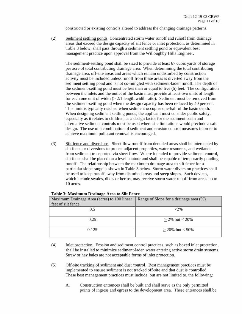
Draft 12-19-03 CRWP Page 11 of 18
constructed or existing controls altered to address the changing drainage patterns.
(2) Sediment settling ponds. Concentrated storm water runoff and runoff from drainage areas that exceed the design capacity of silt fence or inlet protection, as determined in Table 3 below, shall pass through a sediment settling pond or equivalent best management practice upon approval from the Willoughby Hills Engineer.
The sediment-settling pond shall be sized to provide at least 67 cubic yards of storage per acre of total contributing drainage area. When determining the total contributing drainage area, off-site areas and areas which remain undisturbed by construction activity must be included unless runoff from these areas is diverted away from the sediment settling pond and is not co-mingled with sediment-laden runoff. The depth of the sediment-settling pond must be less than or equal to five (5) feet. The configuration between the inlets and the outlet of the basin must provide at least two units of length for each one unit of width (> 2:1 length:width ratio). Sediment must be removed from the sediment-settling pond when the design capacity has been reduced by 40 percent. This limit is typically reached when sediment occupies one-half of the basin depth. When designing sediment settling ponds, the applicant must consider public safety, especially as it relates to children, as a design factor for the sediment basin and alternative sediment controls must be used where site limitations would preclude a safe design. The use of a combination of sediment and erosion control measures in order to achieve maximum pollutant removal is encouraged.
(3) Silt fence and diversions. Sheet flow runoff from denuded areas shall be intercepted by
silt fence or diversions to protect adjacent properties, water resources, and wetlands from sediment transported via sheet flow. Where intended to provide sediment control, silt fence shall be placed on a level contour and shall be capable of temporarily ponding runoff. The relationship between the maximum drainage area to silt fence for a particular slope range is shown in Table 3 below. Storm water diversion practices shall be used to keep runoff away from disturbed areas and steep slopes. Such devices, which include swales, dikes or berms, may receive storm water runoff from areas up to 10 acres.
Table 3: Maximum Drainage Area to Silt Fence Maximum Drainage Area (acres) to 100 linear feet of silt fence
Range of Slope for a drainage area (%)
0.5
<2%
0.25
> 2% but < 20%
0.125
> 20% but < 50%
(4) Inlet protection. Erosion and sediment control practices, such as boxed inlet protection,
shall be installed to minimize sediment-laden water entering active storm drain systems. Straw or hay bales are not acceptable forms of inlet protection.
(5) Off-site tracking of sediment and dust control. Best management practices must be
implemented to ensure sediment is not tracked off-site and that dust is controlled. These best management practices must include, but are not limited to, the following: A. Construction entrances shall be built and shall serve as the only permitted
points of ingress and egress to the development area. These entrances shall be

Draft 12-19-03 CRWP Page 12 of 18
built of a stabilized pad of aggregate stone or recycled concrete or cement sized greater than 2” in diameter, placed over a geotextile fabric, and constructed in conformance with specifications in the most recent edition of the Rainwater and Land Development Manual.
B. Streets directly adjacent to construction entrances and receiving traffic from the
development area, shall be cleaned daily to remove sediment tracked off-site. If applicable, the catch basins on these streets nearest to the construction entrances shall also be cleaned weekly.
Based on site conditions, Willoughby Hills Engineer may require additional best management practices to control off site tracking and dust. These additional BMPs may include:
C. Silt fence or construction fence installed around the perimeter of the
development area to ensure that all vehicle traffic adheres to designated construction entrances.
D. Designated wheel-washing areas. Wash water from these areas must be
directed to a designated sediment trap, the sediment-settling pond, or to a sump pump for dewatering in conformance with Section 1369.09(G) of this regulation.
E. Applicants shall take all necessary measures to comply with applicable
regulations regarding fugitive dust emissions, including obtaining necessary permits for such emissions. The Willoughby Hills Engineer may require dust controls including the use of water trucks to wet disturbed areas, tarping stockpiles, temporary stabilization of disturbed areas, and regulation of the speed of vehicles on the site.
(6) Stream protection. Construction vehicles shall avoid water resources and wetlands. If
the applicant is permitted to disturb areas within 50 feet of a water resource or wetland, the following conditions shall be addressed in the SWP3:
A. All BMPs and stream crossings shall be designed as specified in the most
recent edition of the Rainwater and Land Development Manual. B. Structural practices shall be designated and implemented on site to protect
water resources or wetlands from the impacts of sediment runoff.
C. No structural sediment controls (e.g., the installation of silt fence or a sediment settling pond in-stream) shall be used in a water resource or wetland.
D. Where stream crossings for roads or utilities are necessary and permitted, the
project shall be designed such that the number of stream crossings and the width of the disturbance are minimized.
E. Temporary stream crossings shall be constructed if water resources or wetlands
will be crossed by construction vehicles during construction.
F. Construction of bridges, culverts, or sediment control structures shall not place soil, debris, or other particulate material into or close to the water resources or wetlands in such a manner that it may slough, slip, or erode.

Draft 12-19-03 CRWP Page 13 of 18
(7) Modifying controls. If periodic inspections or other information indicates a control has
been used inappropriately or incorrectly, the applicant shall replace or modify the control for site conditions.
(e) NON-SEDIMENT POLLUTANT CONTROLS: No solid or liquid waste, including building
materials, shall be discharged in storm water runoff. The applicant must implement site best management practices to prevent toxic materials, hazardous materials, or other debris from entering water resources or wetlands. These practices shall include but are not limited to the following:
(1) Waste Materials: A covered Dumpster shall be made available for the proper disposal
of garbage, plaster, drywall, grout, gypsum, and other waste materials. (2) Concrete Truck Wash Out: The washing of concrete material into a street, catch basin,
or other public facility or natural resource is prohibited. A designated area for concrete washout shall be made available.
(3) Fuel/Liquid Tank Storage: All fuel/liquid tanks and drums shall be stored in a marked
storage area. A dike shall be constructed around this storage area with a minimum capacity equal to 110% of the volume of all containers in the storage area.
(4) Toxic or Hazardous Waste Disposal: Any toxic or hazardous waste shall be disposed of
properly.
(5) Contaminated Soils Disposal and Runoff: Contaminated soils from redevelopment sites shall be disposed of properly. Runoff from contaminated soils shall not be discharged from the site. Proper permits shall be obtained for development projects on solid waste landfill sites or redevelopment sites.
(f) COMPLIANCE WITH OTHER REQUIREMENTS. The SWP3 shall be consistent with
applicable State and/or local waste disposal, sanitary sewer, or septic system regulations, including provisions prohibiting waste disposal by open burning, and shall provide for the proper disposal of contaminated soils located within the development area.
(g) TRENCH AND GROUND WATER CONTROL. There shall be no sediment-laden or turbid
discharges to water resources or wetlands resulting from dewatering activities. If trench or ground water contains sediment, it must pass through a sediment-settling pond or other equally effective sediment control device, prior to being discharged from the construction site. Alternatively, sediment may be removed by settling in place or by dewatering into a sump pit, filter bag or comparable practice. Ground water dewatering which does not contain sediment or other pollutants is not required to be treated prior to discharge. However, care must be taken when discharging ground water to ensure that it does not become pollutant-laden by traversing over disturbed soils or other pollutant sources.
(h) INTERNAL INSPECTIONS. All controls on the site shall be inspected at least once every
seven calendar days and within 24 hours after any storm event greater than one-half inch of rain per 24 hour period. The applicant shall assign qualified inspection personnel to conduct these inspections to ensure that the control practices are functional and to evaluate whether the SWP3 is adequate, or whether additional control measures are required. Qualified inspection personnel are individuals with knowledge and experience in the installation and maintenance of sediment and erosion controls.

Draft 12-19-03 CRWP Page 14 of 18
These inspections shall meet the following requirements:
(1) Disturbed areas and areas used for storage of materials that are exposed to precipitation shall be inspected for evidence of or the potential for, pollutants entering the drainage system.
(2) Erosion and sediment control measures identified in the SWP3 shall be observed to
ensure that they are operating correctly.
(3) Discharge locations shall be inspected to determine whether erosion and sediment control measures are effective in preventing significant impacts to the receiving water resource or wetlands.
(4) Locations where vehicles enter or exit the site shall be inspected for evidence of off-site
vehicle tracking.
(5) The applicant shall maintain for three (3) years following final stabilization the results of these inspections, the names and qualifications of personnel making the inspections, the dates of inspections, major observations relating to the implementation of the SWP3, a certification as to whether the facility is in compliance with the SWP3, and information on any incidents of non-compliance determined by these inspections.
(i) MAINTENANCE. The SWP3 shall be designed to minimize maintenance requirements. All
control practices shall be maintained and repaired as needed to ensure continued performance of their intended function until final stabilization. All sediment control practices must be maintained in a functional condition until all up slope areas they control reach final stabilization. The applicant shall provide a description of maintenance procedures needed to ensure the continued performance of control practices and shall ensure a responsible party and adequate funding to conduct this maintenance, all as determined by the Willoughby Hills Engineer.
When inspections required in Section 1639.08(H) reveal the need for repair, replacement, or installation of erosion and sediment control BMPs, the following procedures shall be followed:
(1) When practices require repair or maintenance. If an internal inspection reveals that a
control practice is in need of repair or maintenance, with the exception of a sediment-settling pond, it must be repaired or maintained within three (3) days of the inspection. Sediment settling ponds must be repaired or maintained within ten (10) days of the inspection.
(2) When practices fail to provide their intended function. If an internal inspection reveals
that a control practice fails to perform its intended function as detailed in the SWP3 and that another, more appropriate control practice is required, the SWP3 must be amended and the new control practice must be installed within ten (10) days of the inspection.
(3) When practices depicted on the SWP3 are not installed. If an internal inspection
reveals that a control practice has not been implemented in accordance with the schedule, the control practice must be implemented within ten (10) days from the date of the inspection. If the internal inspection reveals that the planned control practice is not needed, the record must contain a statement of explanation as to why the control practice is not needed.

Draft 12-19-03 CRWP Page 15 of 18
(j) FINAL STABLIZATION. Final stabilization shall be determined by the Willoughby Hills Engineer.
1369.10 ABBREVIATED STORM WATER POLLUTION PREVENTION PLAN
(a) In order to control sediment pollution of water resources and wetlands, the applicant shall submit an Abbreviated SWP3 in accordance with the requirements of this regulation.
(b) The Abbreviated SWP3 shall be certified by a professional engineer, a registered surveyor,
certified professional erosion and sediment control specialist, or a registered landscape architect.
(c) The Abbreviated SWP3 shall include a minimum of the following BMPs. Willoughby Hills
may require other BMPs as site conditions warrant.
(1) Construction Entrances: Construction entrances shall be built and shall serve as the only permitted points of ingress and egress to the development area. These entrances shall be built of a stabilized pad of aggregate stone or recycled concrete or cement sized greater than 2" in diameter, placed over a geotextile fabric, and constructed in conformance with specifications in the most recent edition of the Rainwater and Land Development Manual.
(2) Street Sweeping: Streets directly adjacent to construction entrances and receiving traffic
from the development area, shall be cleaned daily to remove sediment tracked off-site. If applicable, the catch basins on these streets nearest to the construction entrances shall be cleaned weekly.
(3) Stabilization. The development area shall be stabilized as detailed in Table 4.
Table 4: Stabilization
Area requiring stabilization Time frame to apply erosion controls Any disturbed area within 50 feet of a stream and not at final grade.
Within 2 days of the most recent disturbance if that area will remain idle for more than 21 days
For all construction activities, any disturbed area, including soil stockpiles, that will be dormant for more than 21 days but less than one year, and not within 50 feet of a stream.
Within 7 days of the most recent disturbance within the area
Disturbed areas that will be idle over winter Prior to onset of winter weather Note: Where vegetative stabilization techniques may cause structural instability or are otherwise unobtainable, alternative stabilization techniques must be employed. These techniques may include mulching or erosion matting.
(4) Inlet Protection. Erosion and sediment control practices, such as boxed inlet protection, shall be installed to minimize sediment-laden water entering active storm drain systems. Straw or hay bales are not acceptable forms of inlet protection.
(5) Internal Inspection and Maintenance. All controls on the development area shall be
inspected at least once every seven calendar days and within 24 hours after any storm event greater than one-half inch of rain per 24 hour period. Maintenance shall occur as detailed below:
A. When practices require repair or maintenance. If the internal inspection reveals
that a control practice is in need of repair or maintenance, with the exception of

Draft 12-19-03 CRWP Page 16 of 18
a sediment-settling pond, it must be repaired or maintained within three (3) days of the inspection. Sediment settling ponds must be repaired or maintained within ten (10) days of the inspection.
B. When practices fail to provide their intended function. If the internal inspection
reveals that a control practice fails to perform its intended function and that another, more appropriate control practice is required, the Abbreviated SWP3 must be amended and the new control practice must be installed within ten (10) days of the inspection.
C. When practices depicted on the Abbreviated SWP3 are not installed. If the
internal inspection reveals that a control practice has not been implemented in accordance with the schedule, the control practice must be implemented within ten (10) days from the date of the inspection. If the inspection reveals that the planned control practice is not needed, the record must contain a statement of explanation as to why the control practice is not needed.
(6) Final Stabilization: Final stabilization shall be determined by the Willoughby Hills
Engineer.
1369.11 BOND AND PERMIT
(a) No soil disturbing activities shall be permitted until a cash bond has been deposited with the
Willoughby Hills Finance Department to the satisfaction of the Willoughby Hills Engineer sufficient for Willoughby Hills to perform the obligations otherwise to be performed by the owner of the development area as stated in this regulation and to allow all work to be performed as needed in the event that the applicant fails to comply with the provisions of this regulation. The cash bond shall be returned, less Willoughby Hills administrative fees as detailed in Ordinance XXXX, after all work required by this regulation has been completed and final stabilization has been reached, all as determined by the Willoughby Hills Engineer.
(b) No project subject to this regulation shall commence without a SWP3 or Abbreviated SWP3
approved by the Willoughby Hills Engineer. 1369.12 ENFORCEMENT
(a) All development areas may be subject to external inspections by Willoughby Hills to ensure compliance with the approved SWP3 or Abbreviated SWP3.
(b) After each external inspection, Willoughby Hills shall prepare and distribute a status report to
the applicant.
(c) If an external inspection determines that operations are being conducted in violation of the approved SWP3 or Abbreviated SWP3 Willoughby Hills may take action as detailed in Section 1369.12 of this regulation.
1369.13 VIOLATIONS
(a) No person shall violate or cause or knowingly permit to be violated any of the provisions of this regulation, or fail to comply with any of such provisions or with any lawful requirements of any public authority made pursuant to this regulation, or knowingly use or cause or permit the use of
Draft 12-19-03 CRWP Page 17 of 18
any lands in violation of this regulation or in violation of any permit granted under this regulation.
(b) Upon notice, the Willoughby Hills Engineer may suspend any active soil disturbing activity for
a period not to exceed ninety (90) days, and may require immediate erosion and sediment control measures whenever he or she determines that such activity is not meeting the intent of this regulation. Such notice shall be in writing, shall be given to the applicant, and shall state the conditions under which work may be resumed. In instances, however, where the Willoughby Hills Engineer finds that immediate action is necessary for public safety or the public interest, he or she may require that work be stopped upon verbal order pending issuance of the written notice.
1369.99 PENALTY
(a) Whoever violates or fails to comply with any provision of this regulation is guilty of a misdemeanor of the third degree and shall be fined no more than five hundred dollars ($500.00) or imprisoned for no more than sixty (60) days, or both, for each offense. A separate offense shall be deemed committed each day during or on which a violation or noncompliance occurs or continues.
(b) The imposition of any other penalties provided herein shall not preclude Willoughby Hills
instituting an appropriate action or proceeding in a Court of proper jurisdiction to prevent an unlawful development, or to restrain, correct, or abate a violation, or to require compliance with the provisions of this regulation or other applicable laws, ordinances, rules, or regulations, or the orders of the Willoughby Hills Engineer.

Draft 12-19-03 CRWP Page 18 of 18
SECTION 2. That Ordinance 1997-9 adopted April 10, 1997 be and it hereby is repealed as of the effective date of this Ordinance.
SECTION 3. That the actions of this Council concerning and relating to the passage of this legislation were adopted in lawful meetings of this Council and that all deliberations of this Council and any of its committees that resulted in such formal action were in compliance with all legal requirements including Chapter 107 of the Codified Ordinances of the City of Willoughby Hills.
SECTION 4. That this Ordinance shall be in full force and effect at the earliest time permitted by law.
PASSED: _________________________, 2004 __________________________________ President of Council Submitted to the Mayor for his approval on this ____day of __________________, 2004 Approved by the Mayor ______________________________, 2004 ATTEST:
__________________________________ ___________________________________ Victoria Ann Savage Kenneth A. Lorenz Clerk of Council Mayor

Storm Water Phase II Practical Guidance on Immediate Concerns:
June 18, 2003 Willoughby United Methodist Church
Registration………..………………………………………………………………………….8:30 to 9:00
Welcome & Introduction………….………………………………………………………... 9:00 to 9:15
Ohio EPA Phase II Update, Dan Bogoevski, Ohio EPA………...…………………………9:15 to 10:15
Break………...10:15 to 10:30 Construction Site Critical Issues, Dan Donaldson, Lake County SWCD………………...10:30 to 11:15 Illicit Discharge Detection and Elimination Programs………………………………… 11:15 to 12:00
Harry Stark, Cuyahoga County Board of Health Jeff Duke, Northeast Ohio Regional Sewer District Laura Kramer Kuns, Lake County General Health District
Lunch………...12:00 to 12:45 Post Construction Standards, Dan Bogoevski, Ohio EPA………………….……………. 12:45 to 1:15 Rainwater Approach to Post-Construction, John Mathews, Ohio DNR…...……………... 1:15 to 1:45 Post Construction Nonstructural Approaches, Kyle Dreyfuss-Wells, CRWP……………. 1:45 to 2:15
Break…………....2:15 to 2:30 Post Construction Structural Approaches, John Aldrich, CDM………………………….. 2:30 to 3:00
What to Do Now?………...3:00 to 3:30

NPDES Phase II Storm Water:
What You Should Be Doing Today for Phase II Compliance November 19, 2003
Willoughby City Hall 8:30 a.m. – 11:30 a.m.
Introduction. Chris LeGros, CT Consultants……...…..………………………8:30 – 8:35 Phase II Overview. Kyle Dreyfuss-Wells, CRWP….……………………..…..8:35 – 8:50 Illicit Discharge Detection & Elimination. Phil Kiefer, CT Consultants…….8:50 – 9:30
Break……….9:30 – 9:45 Construction Site Management. Dan Donaldson, Lake SWCD…………....9:45 – 10:30 Municipal Pollution Prevention. Chris LeGros.………………...………... 10:30 – 10:50 Next Steps. Kyle Dreyfuss-Wells…………………………..……………….10:50 – 11:10
Remaining Questions. Full Panel……………...………………………… .11:10 – 11:30
Adjourn……………11:30