technical guidelines on implementation of the...
TRANSCRIPT

1
Mekong River Commission For Sustainable Development
Technical Guidelines on Implementation of the Procedures for Maintenance of Flows
on the Mainstream
Draft Final
(10 October 2011)
P.O. Box 6101, Vientiane, Lao PDR Telephone: (856-21)-263 263 Facsimile: (856-21)-263 264
Email: [email protected] Website: www.mrcmekong.org

2
Document History
Date File Name Description Editor 21 Oct 2010 Draft TG • The draft TG, updated after the 9th
TRG meeting for scantioning of implementation by the special JC meeting on 27 October 2010
BDP2
30 Sep 2011 Draft Final TG • Updated Table 2.2 option 2 flow framework 6A-planning purposes
• Updated Figure 2-4 and Figure B-3 flow framework 6B-monitoring purposes
BDP2
10 Oct 2011 Draft Final TG • Added ‘considered as (working) guidelines to parapgraph 6
BDP2
3
Content PREAMBLE ............................................................................................................................................4
ABBREVIATIONS AND ACRONYMS ................................................................................................5
DEFINITION OF TERMS ......................................................................................................................6
1. INTRODUCTION ...........................................................................................................................6
1.1 BACKGROUND..........................................................................................................................7
1.2 OBJECTIVE OF THE TECHNICAL GUIDELINES...........................................................................7
1.3 FLOWS FRAMEWORK ...............................................................................................................8
2. TECHNICAL GUIDELINES.......................................................................................................10
2.1 SELECTION OF HYDROLOGICAL STATIONS............................................................................10
2.2 FLOWS TO BE MAINTAINED...................................................................................................12
2.2.1 DURING THE DRY SEASON (SECTION 5.1.1 OF THE PMFM) ......................................12
A. For Planning Purposes (Pending issue)...............................................................12
B. For Monitoring Purposes.....................................................................................14
2.2.2 DURING THE WET SEASON (SECTION 5.1.2 OF THE PMFM) ......................................19
A. For Planning Purposes ........................................................................................19
B. For Monitoring Purposes.....................................................................................20
2.2.3 DURING THE FLOOD SEASON (SECTION 5.1.3 OF THE PMFM) ..................................22
A. For Planning Purposes ........................................................................................22
B. For monitoring purposes......................................................................................22
2.3 HISTORICALLY SEVERE DROUGHTS AND/OR FLOODS ............................................................24
3. IMPLEMENTATION AND REVIEW OF THE GUIDELINES..............................................25
3.1 IMPLEMENTATION MECHANISMS ..............................................................................25
3.1.1 MRC JOINT COMMITTEE (SECTION 6.2 OF THE PMFM) ............................................25
3.1.2 MRC SECRETARIAT (SECTION 6.3 OF THE PMFM)....................................................25
A. For Planning Purposes ........................................................................................25
B. For Monitoring Purposes.....................................................................................26
C. For Annual Reporting ..........................................................................................27
3.1.3 NATIONAL MEKONG COMMITTEES (SECTION 6.4 OF THE PMFM) ............................28
3.2 INFORMATION EXCHANGE WITH UPPER MEKONG COUNTRIES ........................29
3.3 PERIODIC REVIEW AND UPDATING............................................................................29
ANNEX A: THE PROCEDURES FOR THE MAINTENANCE OF FLOW ON THE MAINSTREAM (PMFM)..................................................................................................30
ANNEX B: EXAMPLE APPLICATIONS OF FLOW FRAMEWORK ..............................................37
ANNEX C: TERMS OF REFERENCE OF TECHNICAL REVIEW GROUP....................................44

4
Preamble The intent of the 1995 Mekong Agreement is to promote cooperation among the riparian countries on the sustainable development and management of the Mekong water and related resources. The intent of the Procedures for Maintenance of Flow on the Mainstream (PMFM) under the provisions of Article 6 and 26 of the 1995 Mekong Agreement is to cooperate on the maintenance of an acceptable hydrological flow regime on the mainstream to optimize the multiple uses and mutual benefits of all riparian countries and to minimize the harmful effects (Article 1). The Technical Guidelines provide an agreed flows framework for long-term planning and real-time monitoring purposes. The flows framework for planning provides the opportunity for the LMB countries to utilize considerable quantities of water of the Mekong without compromising its natural flow regime. Real-time monitoring will provide confidence that the PMFM is being implemented and natural flows are being maintained at key points for meeting important economic, social and environmental needs. When real-time monitoring shows that specific thresholds would be transgressed, investigations will be initiated to identify the cause(s), possible response(s), and mitigating measures. The Technical Guidelines are sanctioned for implementation by the Joint Committee in November 2010. The Guidelines will be considered as ‘working guidelines’ to implement the PMFM. Practical examples of the application of the Guidelines, based on recent scenario assessments and flood and drought events, are provided in an annex. The Guidelines will be implemented during the next years in a ‘learning-by-doing approach’ by the LMB countries, coordinated by the MRC. The Guidelines will be reviewed and updated in 2015, or earlier if there is clear evidence that the flows framework or the implementation arrangements need to be modified. The countries acknowledge that the ongoing hydropower developments in the Mekong Basin will have an impact on the mainstream river flows through the re-regulation of water resources from the wet to the dry season. Given the uncertainties regarding the timing and nature of this man-induced modification of the natural flow regime during the next few years, the countries agree to test the suitability of all flow frameworks for Article 6A – planning purposes that are put forward by the countries. The results obtained will be used to negotiate a mutually preferred flows framework for Article 6A – planning purposes during the next review of the Guidelines.

5
Abbreviations and Acronyms
AIFP MRC Agriculture Irrigation and Forestry Programme
ARI Annual Recurrent Interval
BDP MRC Basin Development Plan Program
DSF
Decision Support Framework – MRC’s suite of computer-based numerical modelling and knowledge based tools
EP MRC Environment Programme
FMMP MRC Flood Management and Mitigation Programme
ICCS MRC International Cooperation and Communication Section
IKMP MRC Information and Knowledge Management Programme
ISH Initiative on Sustainable Hydropower
IWRM Integrated Water Resources Management
JC MRC Joint Committee
LMB Lower Mekong River Basin
M-IWRMP Mekong IWRM Project
MRC Mekong River Commission
MRCS Mekong River Commission Secretariat
NMC National Mekong Committee
NMCS National Mekong Committee Secretariat
NAP MRC Navigation Programme
PDIES Procedures for Data and Information Exchange and Sharing
PMFM Procedures for Maintenance of Flows on the Mainstream
PNPCA Procedures for Notification, Prior Consultation and Agreement
PWQM Procedures for Water Quality Management
PWUM Procedures for Water Use Monitoring
TOR Terms of Reference
TRG Technical Review Group

6
Definition of Terms
1. Introduction
1 It was agreed that these terms are defined as “working definition” to implement the PMFM while it is
acknowledged that the starting and ending dates of wet and dry seasons vary throughout the basin; the wet
Annual recurrence interval
The average annual rate of occurrence of an event; it is equal to the 1/exceedance probability
Annual daily peak flow
The largest daily flow recorded in a year (m3/s)
Average daily peak flows
Peak value of the daily discharge data, which are average values over 24 hours
Confidence interval A range of values centred on the sample estimate that is known to contain the true value with a given degree of confidence
Dry season months1 Six calendar months from December to May (Pending issue)
Flood season months Four calendar months from July to October
Flow duration curve The flow duration curve is a plot of flows ranked from highest to lowest. The x axis is % of time equalled or exceeded and the y axis is flows (m3/s)
Historically severe drought and/or flood
Daily flows exceed the 1:20 annual recurrence interval of historical observed data at any selected station
Monthly flow
The sum of the daily flows in a month divided by the number of days in the month (m3/s). Identical to average flow for the month
Moving average
A method to smooth variations. The average is calculated, for example, over five years. For each year after this, the earliest value is dropped from the calculation and the most recent one is added in, again to make an average over five years; for example: 1988-93, 1989-94, and 1990-95. Also called running average
Natural flows The term natural flows as used in Article 6 indeed means current flows under existing uses up to year 2000.
Probability of exceedence
The statistical probability that an event will be exceeded, e.g. a 99 % probability of exceedence of daily flow means that the flow will exceed this value 99 days of 100 (on average)
Rating curve
A graph of discharge versus stage; the corresponding discharge can be directly read from the graph when a water level is observed
Threshold
A value (or limit) of flow or water level that will cause some action when crossed
Wet season months1 Six calendar months from June to November (Pending issue)

7
1.1 Background
1. In accordance with Article 6 – Maintenance of Flows on the Mainstream - of the 1995 Mekong Agreement, the MRC Member Countries agree “to cooperate in the maintenance of the flows on the mainstream from diversions, storage releases, or other actions of a permanent nature, except in the cases of historically severe droughts and/or floods:
A. Of not less than the acceptable minimum monthly natural flow during each month of the dry season;
B. To enable the acceptable natural reverse flow of the Tonle Sap to take place during the wet season; and
C. To prevent average daily peak flows greater than what naturally occur on the average during the flood season.
2. The MRC Council approved the Procedures for the Maintenance of Flow on the Mainstream (PMFM) on 22 June 2006 in Ho Chi Minh City, Viet Nam. The approved Procedures are provided in Annex A. 3. The PMFM require the MRC Joint Committee to adopt Technical Guidelines for the implementation of the PMFM. Section 5.3 of the PMFM states that: “The Technical Guidelines shall be prepared, reviewed and revised from time-to-time by the MRC Joint Committee in accordance with the objectives and principles of the Procedures”. 4. The Joint Committee delegated the responsibility for the preparation of the Technical Guidelines to the Technical Review Group (TRG) that comprises experts assigned by each of the four National Mekong Committees (NMCs) and staff from the Mekong River Commission Secretariat (MRCS). 5. These Technical Guidelines for the PMFM are agreed by the TRG in October 2010, and sanctioned for implementation by the Joint Committee in November 2010. 1.2 Objective of the Technical Guidelines
6. The main objective the Technical Guidelines is to provide flow frameworks, considered as (working) guidelines for planning and real-time monitoring purposes at each of the selected hydrological stations, with a view to:
1) Planning: to periodically assess future basin-wide development policies and scenarios to inform national and transboundary planning, decision-making and governance processes.
2) Monitoring: to raise awareness of real-time daily flow conditions that are not within the agreed flows framework and discuss whether coordinated action by the Member Countries is needed.
season may start during mid-May to mid-June and end during mid-November to Mid-December (as defined in the PNPCA). Moreover, transition periods can be identified between the dry and wet seasons (Overview of hydrology of the Mekong Basin (MRC, 2005). The definition of wet and dry seasons will be reviewed and updated in 2015, together with the TG, based on new information and understanding.

8
1.3 Flows Framework
7. Figure 1-1 illustrates how the above Objective has been made operational. The agreed flows frameworks presented in these Guidelines will be used to evaluate planning scenarios and real-time flow conditions.
Figure 1-1: Flows framework for the PMFM
Planning 8. The potential impacts of development plans or a large project will be assessed using the simulation models of the DSF. Development plans, or components of plans, or proposed projects are usually grouped within ‘Scenarios’ with the plans and proposed projects added to the existing demands and infrastructure. For each scenario the models of the DSF provide simulated hydrological time-series at each of the selected hydrological stations on the mainstream in the Lower Mekong Basin. . Subsequently, the scenarios will be evaluated with respect to the agreed flows framework for
Simulated flow results of proposed water resources development plans and projects
Real-time monitoring data at agreed hydrological stations
Flows Framework bounded by
“Thresholds”
Planning A plan or project complies with the PMFM Monitoring Stable conditions
Planning A plan or project does not
comply with the PMFM Actions as described in Section 3
Monitoring Unstable conditions Actions as described in Section 3
Planning purpose Monitoring purpose
Within Outside

9
planning purposes. Scenarios that are outside the agreed “thresholds” of the agreed flows framework would be deemed unacceptable. 9. The agreed flows framework for planning puts a boundary around the water quantity dimension of the “Development Opportunity Space” of the IWRM-based Basin Development Strategy. The Strategy identifies the potential for countries to utilize certain quantities of water of the Mekong without compromising its natural flow regime. Monitoring 10. The agreed flows framework for real-time monitoring purposes will provide confidence that the PMFM is being implemented and natural flows are being maintained at key points, hence contributing to maintaining the natural functions of the river. If the monitoring shows that specified thresholds are transgressed (i.e. the ARI 1:10 threshold under Article 6A, the 90% confidence interval under Article 6B, or the ARI 1:10 under Article 6C), investigations will be initiated to identify the cause(s) and possible mitigating measures. 11. The agreed flows framework for real-time monitoring purposes provides the opportunity for the riparian countries to help define severe drought and/or flood events when exceedance of the thresholds is allowable, such as the 2008 flood and the 2010 drought. Uncertainties There are the usual uncertainties associated with the development and use of the agreed flows framework, such as the accuracy of information and analytical tools employed, errors inherent in flow determinations at the selected hydrological stations, and climate change (i.e. how far we can use flow records of the past to predict the future). The risks that such uncertainties may cause in terms of maintaining acceptable flow regimes are small and will be managed by reviewing the Guidelines every five years, based on past implementation experiences and new data and information.

10
2. Technical Guidelines
2.1 Selection of Hydrological Stations
12. As stipulated in Section 5.2 of PMFM, based on the hydro-geographic reach analysis, in total 11 hydrological stations are selected2. Table 2-1 and Figure 2-1 below provide criteria for the selection and location of these stations respectively. 13. The Prek Kdam and Kampong Luong stations are selected for monotoring the acceptable natural reverse flow of the Tonle Sap to take place during the wet season.
Table 2-1: Hydrological stations for monitoring and their geographical criteria
No Station Country Drainage
area (km2)
River Observed data used
Geographical
1 Chiang Saen Thailand 189,000 Mekong 1960-2009 Recognised as transboundary station
2 Vientiane Lao PDR 299,000 Mekong 1960-2009 Key locations above the Nam Ngum confluence
3 Khong Chiam Thailand 419,000 Mekong 1966-2009 Upstream of Kong-Chi-Mun confluence
4 Pakse Lao PDR 545,000 Mekong 1960-2009 Downstream of Kong-Chi-Mun confluence
5 Stung Treng Cambodia 635,000 Mekong 1960-2009 Transboundary flow monitoring Lao/Cambodia
6 Kratie Cambodia 646,000 Mekong 1960-2009 Key station to implement Article 6B
7 Phnom Penh
(Chroui Changvar) Cambodia 663,000 Mekong 1960-2006
Key node in Cambodia floodplain
8 Prek Kdam Cambodia 84,000 Tonle Sap 1996-2006 Key station to implement Article 6B
9 Kampong Luong Cambodia N/A Tonle Sap 1996-2006 Key station to implement Article 6B
10 Tan Chau Viet Nam 760,000 Mekong 1980-2009 Transboundary flow monitoring Cambodia/Viet Nam
11 Chau Doc Viet Nam 760,000 Bassac 1980-2009 Transboundary flow monitoring Cambodia/Viet Nam
2 The agreement reached in 7th TRG meeting, October 2007

11
Figure 2-1: Locations of agreed hydrological stations and reaches
Chiang Saen
Vientiane
Khong Chiam Pakse
Stung Treng
Kratie
Prek Kdam
Kampong Luong
Phnom Penh Tan Chau
Chau Doc
1
2 3
4
5
6

12
2.2 Flows to Be Maintained
14. Flows to be maintained have been determined for planning purposes and monitoring purposes3, as follows.
2.2.1 During the Dry Season (Section 5.1.1 of the PMFM)
A. For Planning Purposes (Pending issue)
15. The acceptable flows framework for planning purposes during the dry season is based on the observed monthly flows in the dry season (Dec-May) during 1986-2000, as simulated by the Baseline scenario in the DSF4 at each of the selected hydrological stations (exclude Kampong Luong and Prek Kdam stations). The following flows frameworks and associated thresholds will be tested:
• Option 1: a range of the 1:4-1:5 years Annul Recurrence Interval (ARI)5
• Option 2: a range of the 80-90% time exceedance of Flow Duration Curve (FDC) 6 Detail values of the flow are presented in Table 2-2 below. 16. For each month a range of thresholds is used to consider the year-to-year natural variation of water availability. In case of a wet year, the minimum monthly flows will be maintained at the upper bound while the lower bound will be applied in case of a dry year. In average, the minimum monthly flow should be maintained between the threshold ranges. 17. A considered scenario could NOT be deemed acceptable for planning purposes under the provisions of Section 5.1.1 if the simulated monthly flow by the DSF is below lower bound for one or more months of the dry season at one or more of the selected hydrological stations. 18. An example of each of the three flow frameworks that will be tested is provided in Annex B.1.1.
3 Planning purposes: as a framework against which to assess a proposed development project or future basin-
wide development scenarios. Monitoring purposes: as a framework to enable appropriate policies to be developed and activated during
critical periods of flow deficiency and excess. 4 It was agreed in the 4th TRG meeting (October, 2004) that the Baseline scenario is formulated from existing
uses and interventions up to year 2000. This scenario will be represented as “natural flow regime”. 5 It is proposed by Cambodia and Viet Nam in 9th RTG meeting, 7 October 2010 6 It is proposed by Lao PDR in National Consultation, 15 October 2010 (need to reconfirm)

13
Table 2-2: Alternative flow frameworks of Section 5.1.1 of the PMFM-Planning Purposes; Option 1: A range of the 1:4 to 1:5 years ARI Unit: m3/s
Station Name ARI Dec Jan Feb Mar Apr May
Chiang Saen 1:4 (Upper bound) 1,432 1,074 859 754 767 1,111
1:5 (Lower bound) 1,398 1,051 837 731 735 1,057
Vientiane 1:4 (Upper bound) 2,193 1,537 1,140 957 1,034 1,532
1:5 (Lower bound) 2,134 1,506 1,117 928 996 1,451
Khong Chiam 1:4 (Upper bound) 3,297 2,253 1,599 1,287 1,372 2,151
1:5 (Lower bound) 3,222 2,210 1,562 1,246 1,325 2,022
Pakse 1:4 (Upper bound) 3,539 2,387 1,719 1,378 1,467 2,187
1:5 (Lower bound) 3,442 2,341 1,677 1,335 1,418 2,056
Stung Treng 1:4 (Upper bound) 5,592 3,362 2,363 1,908 1,866 2,713
1:5 (Lower bound) 5,453 3,287 2,300 1,856 1,799 2,526
Kratie 1:4 (Upper bound) 5,806 3,457 2,413 1,935 1,870 2,748
1:5 (Lower bound) 5,657 3,375 2,345 1,881 1,801 2,555
Phnom Penh 1:4 (Upper bound) 6,112 3,564 2,497 1,952 1,891 2,679
1:5 (Lower bound) 5,952 3,476 2,427 1,897 1,823 2,498
Tan Chau 1:4 (Upper bound) 9,616 6,067 4,038 2,595 2,078 2,590
1:5 (Lower bound) 9,402 5,913 3,913 2,500 1,993 2,447
Chau Doc 1:4 (Upper bound) 1,435 566 257 148 115 188
1:5 (Lower bound) 1,369 539 242 139 107 172
Note: 1:5 years ARI = 80% probability of exceedance 1:4 years ARI = 75% probability of exceedance
14
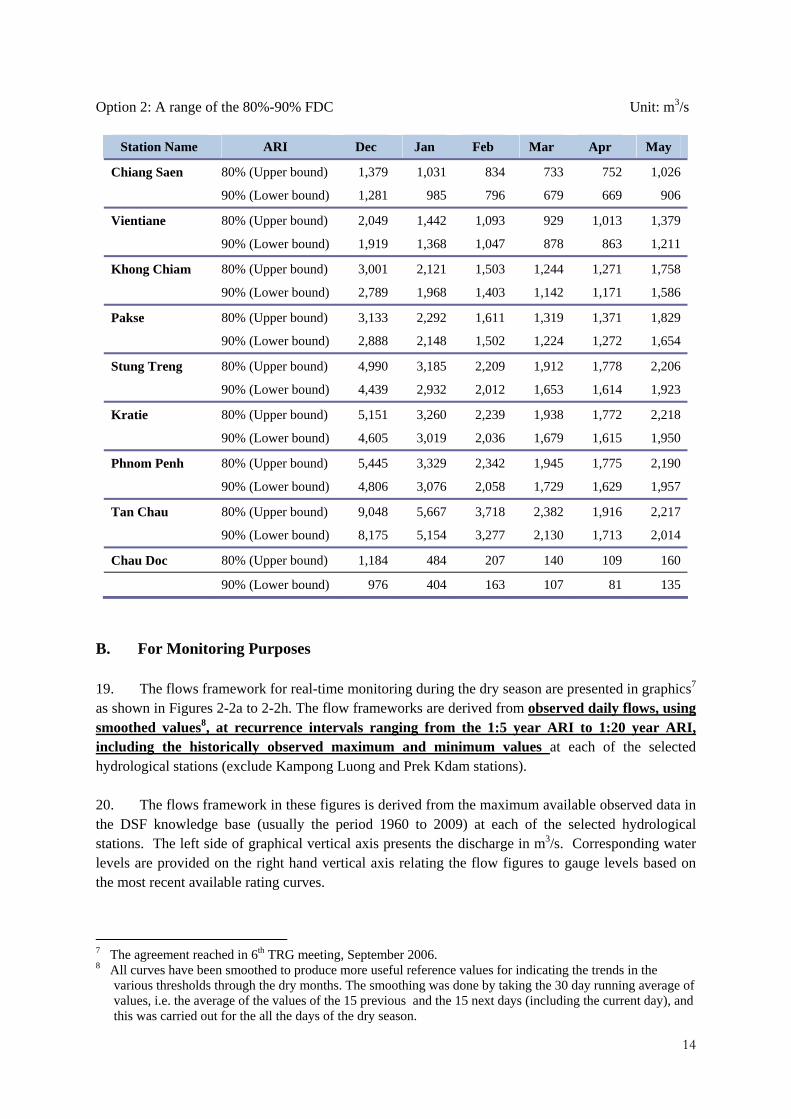
Option 2: A range of the 80%-90% FDC Unit: m3/s
Station Name ARI Dec Jan Feb Mar Apr May
Chiang Saen 80% (Upper bound) 1,379 1,031 834 733 752 1,026
90% (Lower bound) 1,281 985 796 679 669 906
Vientiane 80% (Upper bound) 2,049 1,442 1,093 929 1,013 1,379
90% (Lower bound) 1,919 1,368 1,047 878 863 1,211
Khong Chiam 80% (Upper bound) 3,001 2,121 1,503 1,244 1,271 1,758
90% (Lower bound) 2,789 1,968 1,403 1,142 1,171 1,586
Pakse 80% (Upper bound) 3,133 2,292 1,611 1,319 1,371 1,829
90% (Lower bound) 2,888 2,148 1,502 1,224 1,272 1,654
Stung Treng 80% (Upper bound) 4,990 3,185 2,209 1,912 1,778 2,206
90% (Lower bound) 4,439 2,932 2,012 1,653 1,614 1,923
Kratie 80% (Upper bound) 5,151 3,260 2,239 1,938 1,772 2,218
90% (Lower bound) 4,605 3,019 2,036 1,679 1,615 1,950
Phnom Penh 80% (Upper bound) 5,445 3,329 2,342 1,945 1,775 2,190
90% (Lower bound) 4,806 3,076 2,058 1,729 1,629 1,957
Tan Chau 80% (Upper bound) 9,048 5,667 3,718 2,382 1,916 2,217
90% (Lower bound) 8,175 5,154 3,277 2,130 1,713 2,014
Chau Doc 80% (Upper bound) 1,184 484 207 140 109 160
90% (Lower bound) 976 404 163 107 81 135
B. For Monitoring Purposes 19. The flows framework for real-time monitoring during the dry season are presented in graphics7 as shown in Figures 2-2a to 2-2h. The flow frameworks are derived from observed daily flows, using smoothed values8, at recurrence intervals ranging from the 1:5 year ARI to 1:20 year ARI, including the historically observed maximum and minimum values at each of the selected hydrological stations (exclude Kampong Luong and Prek Kdam stations). 20. The flows framework in these figures is derived from the maximum available observed data in the DSF knowledge base (usually the period 1960 to 2009) at each of the selected hydrological stations. The left side of graphical vertical axis presents the discharge in m3/s. Corresponding water levels are provided on the right hand vertical axis relating the flow figures to gauge levels based on the most recent available rating curves.
7 The agreement reached in 6th TRG meeting, September 2006. 8 All curves have been smoothed to produce more useful reference values for indicating the trends in the
various thresholds through the dry months. The smoothing was done by taking the 30 day running average of values, i.e. the average of the values of the 15 previous and the 15 next days (including the current day), and this was carried out for the all the days of the dry season.

15
21. The measured real-time daily flows from 1 December to 31 May at the selected hydrological stations will be daily plotted and compared with the flows framework shown in Figure 2-2a to 2-2i and the results published on the MRCS website. There are four zones in this flow framework of increasing drought severity, each involving specific actions9.
• Zone 1: If the daily updated actual flow lies above 1:5 year ARI, it means “normal hydrological conditions”; there is no need for action.
• Zone 2: If the daily updated actual flow lies between 1:5 year ARI and 1:10 year ARI, it means that hydrological conditions remain “stable”; there is a need for caution.
• Zone 3: If the daily updated actual flow lies between 1:10 year ARI and 1:20 year ARI, it means that hydrological conditions are “unstable”, investigation should be undertaken to identify the possible cause(s) and possible mitigation measures. There is a need to be on alert.
• Zone 4: If the daily updated actual flow lies below 1:20 year ARI, it means that hydrological conditions are “severe” and the implementation of mitigating measures should be considered.
22. An example of this flow framework is provided in Annex B.1.2.
9 This concept is presented in IBFM Report No.4, November 2004 and Draft Technical Guideline for the
implementation of Procedures for the Maintenance of Flows on the Mainstream, December 2004.

15
Figure 2-2a: Flow framework of Section 5.1.2 of the PMFM-Monitoring
Purposes; 1:5, 1:10 and 1:20 ARI, max/min at Chiang Saen
Figure 2-2b: Flow framework of Section 5.1.2 of the PMFM-Monitoring
Purposes; 1:5, 1:10 and 1:20 AIR, max/min at Vientiane

16
Figure 2-2c: Flow framework of Section 5.1.2 of the PMFM-Monitoring Purposes; 1:5, 1:10 and 1:20 ARI, max/min at Khong Chiam
Figure 2-2d: Flow framework of Section 5.1.2 of the PMFM-Monitoring Purposes; 1:5, 1:10 and 1:20 ARI, max/min at Pakse

17
Figure 2-2e: Flow framework of Section 5.1.2 of the PMFM-Monitoring
Purposes; 1:5, 1:10 and 1:20 ARI, max/min at Kratie
Figure 2-2f: Flow framework of Section 5.1.2 of the PMFM-Monitoring
Purposes; 1:5, 1:10 and 1:20 ARI, max/min at Phnom Penh

18
Figure 2-2g: Flow framework of Section 5.1.2 of the PMFM-Monitoring
Purposes; 1:5, 1:10 and 1:20 ARI, max/min at Tan Chau
Figure 2-2h: Flow framework of Section 5.1.2 of the PMFM-Monitoring Purposes; 1:5, 1:10 and 1:20 ARI, max/min at Chau Doc

19
150
200
250
300
350
400
450
500
550
0102030405060708090100
Wet
Sea
son
Flow
Vol
ume (
109m
3 )
Probability of Exceedance (%)
Wet Season Flow Volume at Kratie (109 m3)
Baseline
Upper 90% C.I.
Lower 90% C.I.
2.2.2 During the Wet Season (Section 5.1.2 of the PMFM)
A. For Planning Purposes 23. The flows framework for planning purposes, is the total wet season flow volume (June through November) at Kratie for the simulated baseline flow regime (1986-2000) in the DSF.10 (Baseline scenario), as presented graphically in Figure 2-3 and numerically in Table 2-3. The annual flow volumes during the wet season at Kratie are to be maintained within the upper and lower 90% confidence interval (or thresholds) around probability of exceedance of the Baseline scenario. 11
Figure 2-3: Flow framework of Section 5.1.2 of the PMFM-Planning Purposes; probability of exceedance
of wet season volume (Jun-Nov) of Baseline scenario at Kratie station with 90% upper and lower confidence interval
10 The agreement reached in the 6th TRG meeting, September 2006. 11 The probability of exceedance is calculated using Log Pearson Type III distribution.

20
Table 2-3: Flow framework of Section 5.1.2 of the PMFM-Planning Purposes; threshold band of wet season volume (Jun-Nov) of Baseline scenario at Kratie station at different probability of exceedance
Probability of Exceedance Wet Season Volume (109 m3)
95% 90% 80% 70% 60% 50% 40% 30% 20% 10% 5%
Upper 90% C.I.
270.7 292.3 319.9 341.2 360.6 379.8 400.2 423.3 451.6 492.8 528.0
Baseline Scenario
219.4 247.1 280.8 305.2 326.2 345.8 365.5 386.7 411.5 446.2 474.9
Lower 90% C.I.
168.0 201.8 241.6 269.2 291.7 311.8 330.8 350.1 371.5 399.5 421.8
24. A considered scenario could NOT be deemed acceptable for planning under the provisions of Section 5.1.2 of the PMFM, if the simulated flow regime by the DSF falls outside the 90% confidence interval (Threshold band).
25. An example of this flow framework is provided in Annex B.2.1.
B. For Monitoring Purposes
26. For the time being, the “threshold band” provided by the historically observed maximum and minimum accumulated reverse flow at Prek Kdam, as shown in Figure 2-4, will be used as the flows framework to evaluate the real-time accumulated reverse flow of the Tonle Sap for monitoring purposes under the provisions of Section 5.1.2 of the PMFM12. 27. To determine the cumulative reverse flow volumes at Prek Kdam, the available data at Kampong Luong, Phnom Penh port and Prek Kdam stations between 1996 and 2005 were used. Although this period is quite short (10 years) to analyse trend and probability in detail, it included however a severe drought event (1998) as well as a severe flood event (2000) in Cambodia13.
28. If the updated actual accumulated reverse flow volume at Prek Kdam lies outside of the maximum and minimum threshold band, it means that hydrological conditions are “unstable”, investigation should be undertaken to identify the possible cause(s) and possible mitigation measures. There is a need to be on alert. 29. An example of this flow framework is provided in Annex B.2.2.
12 The agreement reached in the 6th TRG meeting, September 2006. 13 As this framework is based on a rather short period of historical data, it is advised to check this approach until
such time as more experiences are gained or more appropriate means are determined.

21
0
10
20
30
40
50
60
70
80
90
1-May 1-Jun 1-Jul 1-Aug 1-Sep 1-Oct 1-Nov
Acc
umul
ated
rev
erse
flow
vol
ume
(km
3 )
Dailyaccumulated revrese flow volume to Tonle Sap at Prek Kdam
Average (1996-2006)
Maximum
Minimum
Figure 2-4: Flow framework of Section 5.1.2 of the PMFM-Monitoring Purposes; maximum, minimum
and average daily accumulated reverse flow volumes at Prek Kdam of historical data from 1 May to 31 October

22
2.2.3 During the Flood Season (Section 5.1.3 of the PMFM)
A. For Planning Purposes 30. The flows framework for planning purposes is the average daily peak flow during the flood season14 (July-October) of the simulated baseline flow regime (1986-2000) at each of the selected hydrological stations (exclude Kampong Luong and Prek Kdam stations) as presented in Table 2-4 below. 31. A considered scenario could NOT be deemed acceptable for planning under the provisions of Section 5.1.3 of the PMFM, if one or more simulated daily peak flows in the flood season at one or more hydrological stations are above those thresholds. 32. An example of this flow framework is provided in Annex B.3.1. Table 2-4: Flow framework of Section 5.1.3 of the PMFM-Planning Purposes; Average daily peak during
flood season (Jul-Oct) of Baseline scenario Unit: m3/s
Station Jul Aug Sep Oct Chiang Saen 7,450 8,652 7,727 5,861
Vientiane 10,799 13,723 14,285 9,415 Kong Chiam 22,270 27,251 27,561 17,798
Pakse 24,334 30,720 31,087 20,618 Stung Treng 31,549 40,178 41,003 29,722
Kratie 32,607 41,627 42,936 31,081 Phnom Penh 26,940 32,933 33,663 27,171
Tan Chau 16,386 19,723 21,154 20,837 Chau Doc 3,304 5,119 5,683 5,659
B. For Monitoring Purposes 33. The flows framework for monitoring purposes is a range of recurrence intervals from 1:2 to 1:50 year ARI15 of observed daily peak flows at the selected stations, as given in Table 2-516. It is suggested that the 1:20 year ARI event be used as the critical threshold, while the 1:2 year ARI peak discharges be taken as the quantitative definition of “daily peak flows greater than what naturally occur on the average during the flood season”. 34. The flows framework in Table 2-5 is derived from the maximum available observed data in the DSF knowledge base (usually the period 1960 to 2009) at each of the selected hydrological stations. In
14 This approach is presented in the 8th TRG meeting, April 2010 and no critical comments from member countries. 15 The ARI is determined using General Extreme Value (GEV). 16 Agreement reached in the 6th Meeting, September 2006.

23
the figures, except for the stations were discharge measurements are not available including Phnom Penh, Tan Chau, Chau Doc, data were obtained from observed daily water level
35. Presently, FMMP is working on flood warning on the Mekong mainstream. . The implementation of Section 5.1.3 of the PMFM will supplement the FMMP activities by initiating timely investigations to identify the cause(s) of emerging critical flow condition as well as possible avoidance mitigating measures. Table 2-5: Flow framework of Section 5.1.3 of the PMFM-Monitoring Purposes: The annual recurrence
interval of annual daily peak flow or water level. Unit: Q-m3/s and WL-m.MSL
1:2 year 1:5 year 1:10 year 1:20 year 1:50 year Station Q WL Q WL Q WL Q WL Q WL
Chiang Saen 10,457 366.3 12,567 367.3 13,666 367.8 14,254 368.1 14,929 368.4 Vientiane 16,388 169.2 18,986 170.2 20,144 170.6 20,964 170.8 21,719 171.1
Kong Chiam 35,115 104.5 39,568 105.8 41,079 106.2 41,949 106.5 42,588 106.7 Pakse 38,479 98.5 42,878 99.4 44,442 99.7 45,373 99.9 46,084 100.0
Stung Treng 53,439 47.3 59,144 48.0 61,000 48.2 62,033 48.3 62,767 48.4 Kratie 48,282 21.0 52,542 21.9 53,872 22.1 54,591 22.2 55,084 22.3
Phnom Penh na 10.0 na 10.6 na 11.0 na 11.4 na 11.9 Tan Chau na 4.1 na 4.6 na 4.9 na 5.2 na 5.7 Chau Doc na 3.6 na 4.2 na 4.5 na 4.9 na 5.3
Natural occur Critical flows
36. The measured daily peak flows from 1 July to 31 October at the selected hydrological stations will be compared with the flows framework shown in Table 2-5 and the result published on the MRC website. There are four zones in this flow framework of increasing flood severity, each involving specific actions.
• Zone 1: If the daily updated actual flow lies below 1:2 year ARI, it means “normal hydrological conditions”; there is no need for action.
• Zone 2: If the daily updated actual flow lies between 1:2 year ARI and 1:10 year ARI, it is greater than what naturally occur but it still means that hydrological conditions remain “stable”; there is a need for caution.
• Zone 3: If the daily updated actual flow lies between 1:10 year ARI and 1:20 year ARI, it means that hydrological conditions are “unstable”, investigation should be undertaken to identify the possible cause(s) and possible mitigation measures. There is a need to be on alert. Zone 4: If the daily updated actual flow lies above 1:20 year ARI, it means that hydrological conditions are “severe” and the implementation of mitigating measures should be considered.
37. An example of this flow framework is provided in Annex B.3.2.

24
2.3 Historically Severe Droughts and/or Floods17
38. The PMFM and these Technical Guidelines will apply “except in the cases of historically severe droughts and /or floods” (Section 5.1 of the PMFM). If historically severe droughts or floods occur, other relevant provisions of the 1995 Mekong Agreement shall apply. 39. 18Historically severe droughts occur when the daily updated actual flows or water levels during the dry season are less than the 1: 20 year ARI of historically observed daily flows (usually1960-2009) at the selected hydrological stations, using smoothed values as presented in Figure 2-2a to 2-2i (Section 2.2.1 B-For monitoring purposes). It is noted that the PMFM concerns hydrological droughts only. 40. Historically severe floods occur when the daily updated actual flows or water levels during the flood season are higher than the 1: 20 year ARI of historical annual daily peak flows or water levels (usually1960-2009) at the selected hydrological stations as presented in Table 2-5 (Section 2.2.3 B-For monitoring purposes).
41. The above thresholds of severe droughts and/or floods are applied for the time being – until such time as more experiences or new knowledge are gained.
17 It is recommended to apply the 1:20 year ARI on a trial basis as the threshold for historically-severe
droughts/floods, Background discussion paper: Technical Guidelines for implementation of the PMFM, September 2006.
18 In the case of droughts, it was agreed in the 6th TRG meeting (September, 2006) that they are complex phenomena that require additional factors to fully describe their occurrence – e.g. temperature, soil moisture, rainfall, etc. It was agreed that the matter requires further study and analysis and the secretariat was requested to review previous studies and provide interim recommendations in the next edition of the Technical Guidelines.

25
3. Implementation and Review of the Guidelines
3.1 Implementation Mechanisms
3.1.1 MRC Joint Committee (Section 6.2 of the PMFM)
42. The following are roles and responsibilities:
• In accordance with Section 6.2.2, facilitate, whenever requested and needed, a process of investigation to identify the cause of (emerging) critical flow condition (between 1:10 ARI and 1:20 ARI) and/or mitigating measures.
• In accordance with Section 6.2.1-6.2.4, review the annual PMFM report to the Joint Committee, prepared by the MRCS with facilitation of the NMCs, and approved by the TRG; and provide advice, or make decisions, regarding the implementation of the PMFM.
3.1.2 MRC Secretariat (Section 6.3 of the PMFM)
A. For Planning Purposes
43. The following are roles and responsibilities19:
• For the BDP (Planning Division) to ensure that in assessments of basin-wide development scenarios and major water resources development projects with the DSF will include a check whether the simulated flow regimes comply with the flows framework in these Technical Guidelines.
• For the BDP (Planning Division) to ensure that the periodically reviewed and updated IWRM-based Basin Development Strategy complies with these Technical Guidelines.
• For the BDP (Planning Division) to provide policy advice to support national planning, decision-making and governance processes regarding the opportunities and limitations for national consumptive water uses (irrigation, water supply, wetland management and others).
• For the BDP (Planning Division) to promote the consumptive use opportunities of surplus water resources of the PMFM for economic growth and poverty reduction among stakeholders within Government, parliament, Sub-basin organizations, and national and foreign investors as well as promote non consumptive uses when the natural flow needs to be maintained.
• For the AIP (Operations Division), FMMP (Technical Support Division) and ISH (Planning Division) to update the irrigation, hydropower and flood protection databases every 2-3 years
19 In this Section reference is made to current MRC programmes, assuming that the programmes will continue until
2015. If a programme will not continue through 2015 then the implementation responsibility will be with the MRCS division under which this programme operated.

26
to keep track of the major water use and control projects that are in operation and various stages of planning (identification, feasibility etc.). This would also help implement the Procedures for Water Use Monitoring (PWUM).
• For M-IWRMP (Planning Division) to help improve the effectiveness of implementation of the other MRC procedures, such as PWUP and PDIES, which would support the implementation of the PMFM
B. For Monitoring Purposes
44. The following are roles and responsibilities:
• For IKMP (Technical Support Division), in consultation with FMMP (Operations Division), to develop an appropriate website for tracking the day-to-day compliance of the actual flows at the selected hydrological stations with the agreed flows framework for monitoring under Section 5.1.1 to 5.1.3 of the PMFM. The web-site will also need to keep track of the actions taken to: 1) raise awareness of emerging critical flow conditions, 2) assess the causes of these flow conditions, and 3) mitigate critical flow conditions.
• For the IKMP (Technical Support Division) and FMMP (Operations Division) to maintain the above web-site, and to communicate with the BDP when agreed flow thresholds for monitoring under Section 5.1.1 to 5.1.3 of the PMFM are transgressed.
• For the BDP (Planning Division) to communicate with the NMCSs, IKMP (Technical Support Division) and others regarding the timing and scope of actions required to address (emerging) critical flow conditions in the basin.
• For the IKMP (Technical Support Division) to conduct rapid assessments and diagnostic studies to evaluate and describe the causes of (emerging) critical flow conditions. The possible causes could include reservoir operations, extreme weather conditions, and unusual water diversions. This may require immediate data and information collection and exchange between Government agencies, water infrastructure operators and others at the national and sub-basin levels (through the active application of the Procedures for Data and Information Exchange and Sharing-PDIES), which will be facilitated by the NMCSs.
• For the BDP (Planning Division) to guide and support coordinated action by the countries to address (potential) critical flow situations and transgressions of the Technical Guidelines. The possible action could include the intensification of public reporting to raise awareness of emerging critical flow conditions, warning of water users and operators, requests to dam operators to release or store more water, assessment of the readiness of drought (and flood) contingency plans and actions, and the implementation of drought contingency plans, all facilitated by the NMCSs.

27
C. For Annual Reporting
45. The following are roles and responsibilities:
• For the BDP (Planning Division) to organize meetings of the TRG whenever necessary or appropriate. Once a year, in advance of the annual reporting to the Joint Committee, the TRG will meet to discuss and finalize the annual PMFM report to the Joint Committee.
• For IKMP (Technical Support Division) to use the flow frameworks for monitoring purposes of Section 5.1.1 and 5.1.2 of the PMFM in this Technical Guideline for the preparation of the annual hydrological report.
• For FMMP (Technical Support Division) to use the flow frameworks for monitoring purposes of Section 5.1.3 of the PMFM in this Technical Guideline for the preparation of the annual flood report.
• For the BDP (Planning Division) to prepare the annual PMFM report to the Joint Committee that will describe how the Technical Guidelines of the PMMF have been implemented during the preceding year and how the guidelines have supported national and transboundary planning, decision making and governance processes. The report would:
a. Summarize evaluation of the monitored flow regime data of the preceding year from annual hydrological and flood reports;
b. Explain any transgressions of the agreed flows framework;
c. Describe coordinated action taken during the year, if any, on the basis of real time flow monitoring at the agreed stations, such as: diagnostic studies to explain the causes of (emerging) critical flow conditions and transgressions of the Technical Guidelines (reservoir operations, extreme weather conditions, unusual water diversions etc.); intensification of public reporting to raise awareness of emerging critical flow conditions; warning of water users and operators; requests to dam operators and/or irrigation operators to make changes in their near-term operations; assessment of the readiness of drought (and flood) contingency plans and actions; and the implementation of drought contingency plans.
d. Summarize the implication of the updated Basin-wide development scenario assessment and the IWRM-based Basin Development Strategy for the Technical Guideline of the PMFM.
e. Identify flow related issues and opportunities, including consumptive use projects for economic development and poverty alleviation;
f. Recommend further studies, if needed;
g. Identify good practices, draw lessons, and make recommendations to improve the PMFM process; and

28
h. Make policy recommendations for national planning and transboundary water cooperation.
3.1.3 National Mekong Committees (Section 6.4 of the PMFM)
46. The following are roles and responsibilities:
• In accordance with Section 6.2 of the PMFM, for the NMCSs to adapt the staffing of the TRG to the requirements of the implementation of the PMFM, including data and information collection and exchange regarding consumptive uses and water control (i.e. the irrigated agriculture and hydropower sectors). The updated TOR of the TRG is provided in Annex C.
• In accordance with Section 6.4.1,
a. for the NMCSs to facilitate rapid assessments and diagnostic studies by IKMP (Technical Support Division) to evaluate and describe the causes of (emerging) critical flow conditions. This may require immediate data and information collection and exchange between Government agencies, water infrastructure operators and others at the national and sub-basin levels, which will be facilitated by the NMCSs;
b. for the NMCSs to steer, support and facilitate the implementation of action at the national level to address (potential) critical flow situations and transgressions of the Technical Guidelines. The possible action could include: the intensification of public reporting to raise awareness of (emerging) critical flow conditions; warning of water users and operators; requests to dam operators to release or store more water; assessment of the readiness of drought (and flood) contingency plans and actions; the implementation of drought contingency plans, etc;
c. for the NMCSs to support the BDP (Planning Division) in the organization of ad hoc and annual meetings of the TRG.
• In accordance with Section 6.4.4, for the NMCSs to communicate relevant decisions, good practices and recommendations related to the implementation of the PMFM to the appropriate national agencies and other stakeholders.

29
3.2 Information Exchange with Upper Mekong Countries 47. The technical exchange with China on the changes expected from dam impoundment and operation will be further improved. Early warning for unexpected changes due to the types of circumstances outlined above will be particularly important. Also additional hydrological monitoring stations in the Upper Mekong mainstream as well as improved data exchange are essential to manage the above risks. All of this is part of an ongoing dialogue process on strengthening cooperation between the MRC and the Upper Mekong Basin countries.
3.3 Periodic Review and Updating 48. The Technical Guidelines of the PMFM will be reviewed every five years. This should be done in parallel with the update of the State-of-Basin Report and the review of the IWRM-based Basin Development Strategy. The next formal review will take place in 2015 and this is an appropriate timeframe for reviewing the relevance and effectiveness of the Guidelines and taking stock of the lessons learned. 49. The next formal update of the Technical Guidelines will then be considered by the MRC Joint Committee in 2015/2016.
50. In case of concerns regarding a critical event or ineffective implementation of the PMFM, the TRG could recommend that the Technical Guidelines be revised earlier than 2015/2015.

30
Annex A: The Procedures for the Maintenance of Flow on the Mainstream (PMFM)

31

32

33

34

35

36

37
Annex B: Example applications of flow framework
B.1 During the Dry Season
B.1.1 For Planning Purposes
Waiting for agreement of flow framework

38
B.1.2 For Monitoring Purposes
Example application Figure B-1 shows a plot of the daily updated actual discharge (blue line) in the agreed flows framework for the implementation of Article 6A-monitoring at Phnom Penh during December to May 2006.
Figure B-1: Application graph of flow framework of the PMFM during dry season-monitoring purposes
with observed data in 2009/2010 during the dry season at Vientiane Figure B-2 shows that the daily measured actual water levels (red line) lay between the 1:5 year ARI and 1:10 year ARI since December to mid January. It means that the hydrological situation during this period is in “acceptable situation”. However, there is a need for caution and some degree of reporting should be instigated.
0
1000
2000
3000
4000
5000
6000
Dec
Jan
Feb
Mar
Apr
May
Discha
rge, m3/s
Vientiane
Average(1960‐2009)Max and Min1:5 year High and Low1:10 Year High and Low1:20 year High and LowObserved Flow 2010
39
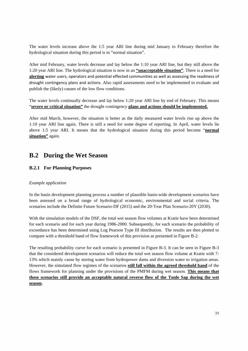
The water levels increase above the 1:5 year ARI line during mid January to February therefore the hydrological situation during this period is in “normal situation”.
After mid February, water levels decrease and lay below the 1:10 year ARI line, but they still above the 1:20 year ARI line. The hydrological situation is now in an “unacceptable situation”. There is a need for alerting water users, operators and potential effected communities as well as assessing the readiness of drought contingency plans and actions. Also rapid assessments need to be implemented to evaluate and publish the (likely) causes of the low flow conditions. The water levels continually decrease and lay below 1:20 year ARI line by end of February. This means “severe or critical situation” the drought contingency plans and actions should be implemented. After mid March, however, the situation is better as the daily measured water levels rise up above the 1:10 year ARI line again. There is still a need for some degree of reporting. In April, water levels lie above 1:5 year ARI. It means that the hydrological situation during this period become “normal situation” again.
B.2 During the Wet Season
B.2.1 For Planning Purposes
Example application In the basin development planning process a number of plausible basin-wide development scenarios have been assessed on a broad range of hydrological economic, environmental and social criteria. The scenarios include the Definite Future Scenario-DF (2015) and the 20-Year Plan Scenario-20Y (2030). With the simulation models of the DSF, the total wet season flow volumes at Kratie have been determined for each scenario and for each year during 1986-2000. Subsequently, for each scenario the probability of exceedance has been determined using Log Pearson Type III distribution. The results are then plotted to compare with a threshold band of flow framework of this provision as presented in Figure B-2. The resulting probability curve for each scenario is presented in Figure B-3. It can be seen in Figure B-3 that the considered development scenarios will reduce the total wet season flow volume at Kratie with 7-13% which mainly cause by storing water from hydropower dams and diversion water to irrigation areas. However, the simulated flow regimes of the scenarios still fall within the agreed threshold band of the flows framework for planning under the provisions of the PMFM during wet season. This means that these scenarios still provide an acceptable natural reverse flow of the Tonle Sap during the wet season.

40
150
200
250
300
350
400
450
500
550
0102030405060708090100
Wet
Sea
son
Flow
Vol
ume (
109
m3 )
Probability of Exceedance (%)
Wet Season Flow Volume at Kratie (109 m3)
Baseline
Upper Mekong Dam
Definite Future
20Y-Plan
Upper 90% C.I.
Lower 90% C.I.
Figure B-2: Comparison of probability of exceedance of wet season volume (Jun-Nov) of development
scenarios at Kratie station with flow framework of the PMFM during wet season-Planning Purposes
However, probability of exceedance between 25%-60% of the 20-Year Plan Scenario flow regime lies very close to the lower boundary of this flow framework. If this probability curve of this scenario would transgress this lower boundary, than the scenario assessment results suggest that full compliance with the agreed flows framework could be achieved if the proposed reservoir storages were operated in a way that released more water or irrigation demands or diversions reduced in dryer years such that the flood volumes in the mainstream are maintained.

41
B.2.2 For Monitoring Purposes
Example application The accumulated real-time monitoring of the reverse flow at Prek Kdam in 2006 is plotted in Figure B-3 (red line) for comparison with the acceptable flow framework of the PMFM during wet season-monitoring purposes. The results show that the accumulated reverse flows lay in the centre of the “threshold band” and therefore represent normal or acceptable hydrological conditions. However, Figure B-3 shows that the accumulated reverse flow volume to Tonle Sap in June/July 2006 (beginning of wet season) is significantly lower than the historically observed average situation (1996-2006), which would require close monitoring and some degree of reporting. The accumulated reverse flow volume at Prek Kdam increases considerably in July and August and approaches average hydrological conditions at the end of reverse flow period (September/October).
0
10
20
30
40
50
60
70
80
90
1-May 1-Jun 1-Jul 1-Aug 1-Sep 1-Oct 1-Nov
Acc
umul
ated
rev
erse
flow
vol
ume
(km
3 )
Dailyaccumulated revrese flow volume to Tonle Sap at Prek Kdam
Average (1996-2006)MaximumMinimumYear 2006
Figure B-3: Comparison of accumulated actual reverse flow from May-October in 2006 at Prek Kdam
with flow framework of the PMFM during wet season-Monitoring Purposes

42
6,000
7,000
8,000
9,000
10,000
11,000
12,000
13,000
14,000
15,000
Jul Aug Sep Oct
Disc
harg
e (m
3/s)
Vientiane
BL DF 20Y
B.3 During the flood season
B.3.1 For Planning Purposes
Example application In the basin development planning process a number of plausible basin-wide development scenarios have been assessed on a broad range of hydrological economic, environmental and social criteria. The scenarios include the Definite Future Scenario-DF (2015) and the 20-Year Plan Scenario-20Y (2030). For each scenario, the average daily peak flow was estimated by abstracting the annual peak daily flow in each month during flood season (Jul-Oct) for the 15 years simulated (1986-2000) from the DSF, and calculating the average for each scenario. The simulated average daily peak flows are then compared with thresholds of flow framework of this provision as presented in Table 2-4. The example results for the Vientiane hydrological station are shown in Figure B-4. The picture at Vientiane is consistent with all the other stations wherein there is a predicted reduction in average daily peak flows in each month At Vientiane (below thesholds), in the the peak month of September, peak flows will typically reduce by 1,170 m3/s (0.50 m) or 8% in the Definite Future Scenario. The LMB 20-Year Plan Scenarios would further reduce the peak flows with 242 m3/s (0.11 m) or 2%. Thus it may conclude that considered scenarios would be deemed acceptable for planning under the provisions of the PMFM during flood season.
Figure B-4: Comparison of simulated average daily peak flows during the flood season months of development scenarios with flow framework of the PMFM during flood season-Planning Purposes (dot line)
Station Scenario Jul Aug Sep Oct Baseline
(Threshold) 10,799 13,723 14,285 9,415
Definite Future 8,844 11,201 13,115 8,752 Vientiane
20-Year Plan 8,212 10,812 12,873 8,756

43
0
5,000
10,000
15,000
20,000
25,000
1‐Jul‐0
8
8‐Jul‐0
8
15‐Jul‐08
22‐Jul‐08
29‐Jul‐08
5‐Au
g‐08
12‐Aug
‐08
19‐Aug
‐08
26‐Aug
‐08
2‐Sep‐08
9‐Sep‐08
16‐Sep
‐08
23‐Sep
‐08
30‐Sep
‐08
7‐Oct‐08
Observed discharge, m3/s
1:2 ARI
1:5 ARI1:10 ARI
1:20 ARI
B.3.2 For Monitoring Purposes Example application The observed daily flows during flood season (Jul-Oct) in 2008 at Vientiane are plotted in Figure B-5. These observed daily flows are then compared with flow framework of the PMFM during flood season-monitoring purposes (Table 2-5 in the TG). During 10 -13 August, the observed daily flows rise up between 1:2 ARI to 1:10 ARI which higher than natural occur (1:2 ARI). However, it still means that hydrological conditions remain “acceptable situation”, there is no need for any restrictions, but there is a need for caution. The causes of the higher than natural peak flows will be rapid investigated.
The flows still continually increase and lay above 1:10 ARI on 14 August. It means that hydrological conditions are “unacceptable situation”; a rapid assessment needs to be implemented to evaluate and publish the (likely) causes of the high flow conditions. Water users, operators and potentially affected communities should be alerted. Also, the readiness of flood mitigation plans and actions should be assessed. On 16 August, the observed flow is higher than 1:20 ARI. It is “severe or critical situation”. In this case the actions to be taken would be to examine the storm rainfall data and tributary flows in order to establish whether such a localised incidence of severe flood conditions can be explained in meteorological terms. If not then the operation of the tributary reservoirs would need to be examined in order to establish rates of draw down via crest gate operation for example and whether these are the cause of the apparent transgression flow framework of the PMFM during flood season.
Figure B-5: Comparison of observed daily flows during the flood season months at Vientiane in 2008 with flow framework of the PMFM during flood season-Monitoring Purposes

44
Annex C: Terms of Reference of Technical Review Group For the Implementation of the Technical Guidelines of the PMFM
1. Background and Justification In 2006 the Mekong River Commission (MRC) Council approved the Procedures for Maintenance of Flows on the Mainstream (PMFM) and assigned the MRC Joint Committee (JC) to prepare the Technical Guidelines for implementation. The MRC Joint Committee subsequently delegated the responsibility for preparation of the Technical Guidelines to the Technical Review Group (TRG). The TRG comprises experts assigned by the National Mekong Committees (NMCs) of the four MRC member Countries, as well as a few staff of the Mekong River Commission Secretariat (MRCS). With Technical Guidelines, the implementation of the PMFM will enhance the sustainable management of the river’s natural resources for mutual benefits of the riparian countries. Given the linkages between the Guidelines and national planning and governance processes, it is essential that the implementation of the Guidelines will be driven by the interest and priorities of the member countries and their people. To ensure a meaningful participation of key stakeholders from the four Member Countries in the implementation of the Technical Guidelines, the staffing and operations of the TRG will be adapted to the requirements of the implementation of the Technical Guidelines.
2. Objective of the TRG The key objective of the TRG is to support the process of implementing the Technical Guidelines for the PMFM. Accordingly, the TRG will:
• Ensure the relevance and enabling aspects of the Technical Guidelines for transboundary and national water resources planning and management; and
• To strengthen the role of the appropriate line agencies and other stakeholders in the process.
3. Functions of the TRG The functions of the TRG related to the planning purposes of the Guidelines include the following:
1) Reviewing the periodic assessment of basin-wide development scenarios in order to ensure that the assessments have considered compliance of the simulated flow regimes with the flows framework in the Technical Guidelines.
2) Reviewing the results of scenario assessments and the periodically updated IWRM-based Basin Development Strategy in order to identify implications, if any, for the PMFM.

45
3) Providing policy advice to support national planning, decision-making and governance processes regarding the opportunities and limitations of national consumptive water uses, in particular irrigated agriculture.
4) Promoting the consumptive use opportunities of the PMFM for economic growth and poverty reduction among stakeholders within Government, Parliament, Sub-basin organizations, and national and foreign investors.
5) If requested, facilitating the exchange of data and information between the MRC Member Countries and the MRCS in accordance with agreed MRC procedures.
The functions of the TRG related to real-time flow monitoring purposes of the Guidelines include the following:
6) Periodically reviewing of the effectiveness of the established web-site for tracking of the implementation of the Technical Guidelines. The website is especially important for raising awareness of real-time flow conditions as well as supporting information that explains the causes of and the actions taken to address (emerging) critical flow conditions and transgressions of the Guidelines.
7) Facilitating the implementation of rapid assessments and diagnostic studies to identify and describe the causes of (emerging) critical flow conditions and transgressions of the Technical Guidelines. The possible causes could include reservoir operations, extreme weather conditions, unusual water diversions, etc. The national TRG members would: 1) facilitate the early availability of essential data, such as daily data on reservoir storage and releases in one or more tributaries and data on irrigation withdrawals and 2) support the analysis of the issues and the identification of mitigating measures.
8) Coordinating and support the agreed actions taken in the countries. The possible action could include the intensification of public reporting to raise awareness of an emerging critical flow conditions, warning of water users and operators, requests to dam operators to release or store more water, assessment of the readiness of drought (and flood) contingency plans and actions, implementation of drought contingency plans, etc.
Other tasks of the TRG are:
9) Representing in meetings the views and interests of the Member Countries, and ensuring the relevance and enabling aspects of the Technical Guidelines of the PMFM for water resources planning and management in the Lower Mekong Basin.
10) Supporting the preparation an annual PMFM report to the Joint Committee that describes how the Technical Guidelines of the PMMF were implemented during the preceding year and what were the benefits for the countries and their people, and how the PMFM process can be improved.

46
4. Members of the TRG
The TRG will comprise of four members from each MRC Member Country and four staff of the MRCS. The following guidance is provided for the selection of the members:
1) A representative of the NMC.
2) A representative of the water using sectors that impact water flows most, including hydropower and irrigation. Preferably, the two representatives will be senior staff with responsibilities for planning in the line agencies responsible for irrigated agriculture and hydropower.
3) A senior hydrologist with good knowledge of the hydrology of the Mekong Basin, hydrological methods and tools, and water use by the various water related sectors.
4) The suggested members of the MRCS comprise the Director of the Planning Division, the Coordinator of the BDP 2011-2015, the Chief Hydrologist (IKMP) and a fourth staff from a relevant programme, project/unit (M-IWRMP, ICCS, TCU).
The members will be nominated by the NMCs, in consultation with the MRCS. Since, the PMFM would have implications for national development policies and plans, the TRG members must be senior government officials and experts.
5. Meetings of the TRG
Workshops or meetings will be convened as decided by the NMCs in consultation with the MRCS. The meetings will be moderated by the Director of the Planning Division. It is anticipated that meetings will be held in connection to:
o Scenario assessment and updating of the IWRM-based Basin Development Strategy (a few meetings every five years).
o When important thresholds related to real-time monitoring are transgressed: the ARI 1:5 (1:10) threshold under Article 6A, the 90% confidence interval under Article 6B, or the ARI 1:10 under Article 6C.
o In advance of the annual reporting to the Joint Committee (once a year).
o Informal meetings may be held in between the workshops to discuss or resolve specific issues. At least two weeks before the TRG meeting, the MRC Planning Division will send the documents for the meeting to all members of the TRG. Likewise, the TRG members will submit their contributions, such as country briefs, one week in advance of a meeting to the MRCS. A meeting report will be prepared by the MRCS. The TRG members may bring an additional participant to a meeting as needed at the discretion of the NMC and the MRC Planning Division.
47
6. Facilitation and Administrative Support
The BDP 2011-2015 of the MRCS Planning Division will facilitate and support the process of implementing the Technical Guidelines of the PMFM at the regional level. This includes coordination, logistical support, meeting agendas, minutes of meetings, technical notes, annual reporting to the Joint Committee, as outlined in the Technical Guidelines. Technical support will be provided by the Information and Knowledge Management (IKMP) Programme (hydrologists, modellers, and data base specialists), the Flood Management and Mitigation Programme (FMMP), the Initiative for Sustainable Hydropower (ISH), the Agriculture, Irrigation and Forestry Programme (AIFP) and other MRC Programmes, as needed. This includes the maintenance of the PMFM website, the periodic updating of the hydropower, irrigation and flood measures databases, and rapid assessments and diagnostic studies, as outlined in the Technical Guidelines. The National Mekong Committee Secretariats (NMCSs) will facilitate and support the implementation of action at the national level to address (potential) critical flow situations and transgressions of the Technical Guidelines. This includes the intensification of public reporting to raise awareness of emerging critical flow conditions, warning of water users and operators, and the organization of mitigating actions, as described in the Technical Guidelines. The Mekong IWRM Project will fund meetings and associated costs, as well as consultant inputs, if needed. As required, a convener will be nominated to facilitate meetings and coordinate follow-up actions among the members of the TRG. The Convener may also provide inputs, as required, to support the review and approval of intermediate and draft final agreements the Joint Committee.
7. Amendment of this TOR
Any amendment of the TOR would be endorsed by the Joint Committee