technical evidence paper wcs -q energy from waste and
TRANSCRIPT

1
Waste Core Strategy Technical Evidence Paper WCS-Q Energy from Waste and Combined Heat & Power Potential December 2010

2
Contents
Section 1: Introduction
Section 2: What is Energy from Waste (EfW)?
Section 3: What is Combined Heat and Power (CHP)?
Section 4: Assessing the CHP potential of the 13 site options
Appendices
Appendix 1: Sources of Further Information

3
1. Introduction 1.1 This paper is one of a series of evidence papers produced in support of the Waste Core
Strategy (WCS). The purpose of the paper is to explore the potential for Energy from Waste
(EfW) powered Combined Heat and Power (CHP) at each of the 13 sites identified in the
Waste Core Strategy Site Options consultation (October 2009). Therefore it will provide
background as to the CHP potential for any sites that are taken forward in the process for
inclusion in the WCS or any future DPD.
4
2. What is Energy from Waste (EfW)?
2.1 One of the Government’s key objectives in The Waste Strategy for England (2007) is to
maximise environmental benefit from investment in waste infrastructure “through increased
recycling of resources and recovery of energy from residual waste using a mix of
technologies”. The Waste Strategy for England encourages the implementation of the
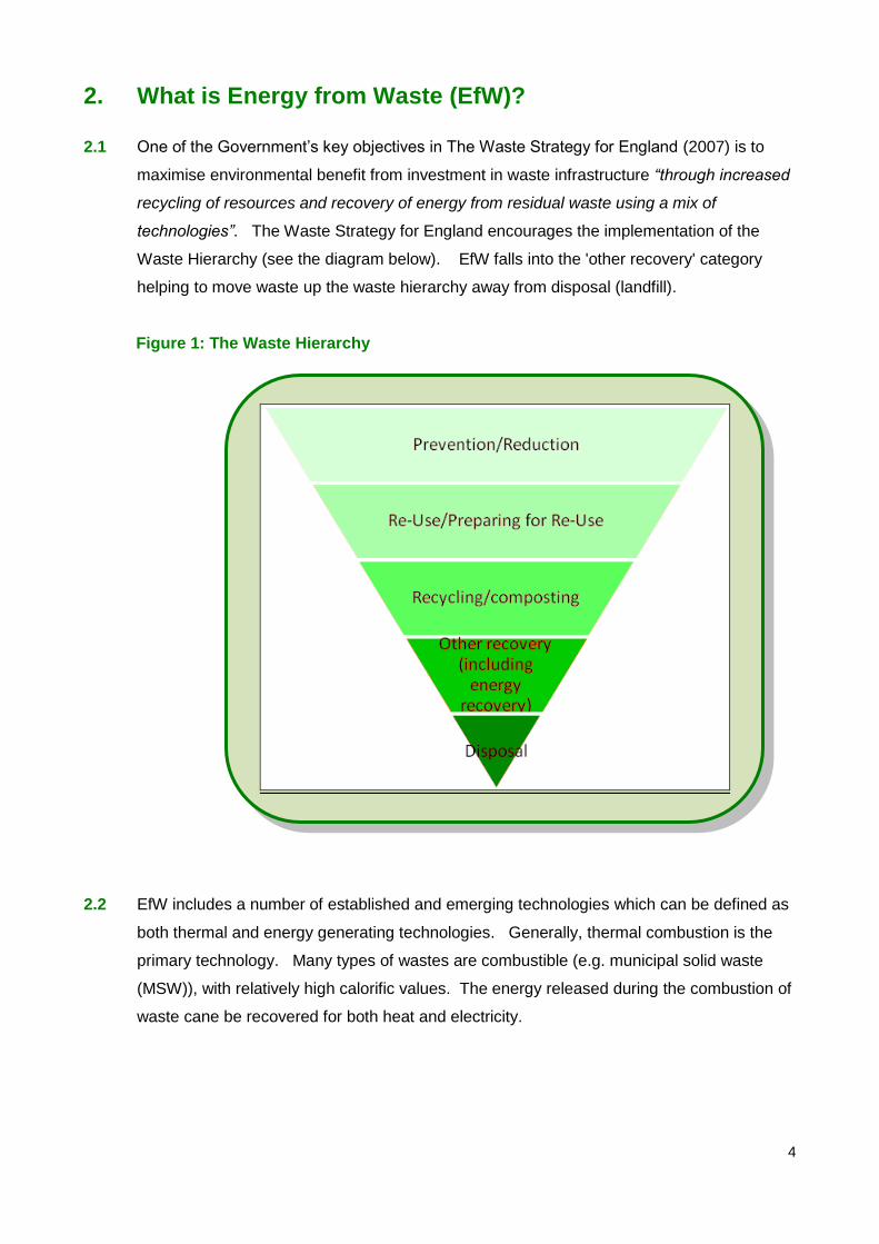
Waste Hierarchy (see the diagram below). EfW falls into the 'other recovery' category
helping to move waste up the waste hierarchy away from disposal (landfill).
Figure 1: The Waste Hierarchy
2.2 EfW includes a number of established and emerging technologies which can be defined as
both thermal and energy generating technologies. Generally, thermal combustion is the
primary technology. Many types of wastes are combustible (e.g. municipal solid waste
(MSW)), with relatively high calorific values. The energy released during the combustion of
waste cane be recovered for both heat and electricity.

5
2.3 Annex E of the The Waste Strategy for England (2007) lists various EfW technologies,
these are:
Direct Combustion (Incineration);
Advanced Thermal Treatment (ATT) - Gasification & Pyrolysis and;
Anaerobic Digestion (AD)
2.4 The government states that a technology is more beneficial if both heat and electricity can
be recovered from the waste recovery process.
Direct Combustion (Incineration)
2.5 Incineration involves the combustion of waste being burnt at temperatures over 850°C. On
arrival at the facility the waste (generally MSW and Commercial and Industrial waste (C&I))
is mixed and sometimes shredded to a more homogenous fuel that will combust. It is then
moved to a combustion chamber where oxygen is added. Combusting the waste turns
most of it into carbon dioxide, other gases and water. The process releases energy which,
through use of a boiler system, can be harnessed and turned into electricity and heat
energy.
2.6 Any material that won't burn (glass, metal, stones) collects at the bottom of the combustion
chamber and is known as bottom ash. Incinerators also create gases which are generally
acidic and contain particles. Prior to being released into the atmosphere the gases are
cleaned carefully to neutralise the acidity and remove the particles. The particles collected
along with the excess cleaning chemicals are known as fly-ash (Air Pollution Control
Residues (APC Residues)), which are classed as hazardous waste.
2.7 Modern incinerators generate and capture heat and electricity which may be used on or off-
site thereby contributing to renewable energy targets1. In some instances, incineration may
be used in conjunction with other waste management technologies as part of an integrated
facility. For example, using a pre-treatment technology such as mechanical treatment to
extract metal, glass or plastics from the waste before it is combusted or using a Mechanical
Biological Treatment (MBT) facility to produce a fuel (Refuse Derived Fuel (RDF) or Solid
Recovered Fuel (SRF)) to be used in an incinerator of other ATT process
1 The degree to which ‘renewable energy’ is generated will depend to a large extent on the nature of the waste being incinerated.

6
Advanced Thermal Treatment (ATT) - Gasification & Pyrolysis
2.8 ATT is a general term used for two different technologies, pyrolysis and gasification, which
can be used as part of a solution separately or together. The main difference between
ATT and incineration is the amount of oxygen used and the temperature in the combustion
chamber.
2.9 Gasification is a similar process to pyrolysis, but with some oxygen (although not as much
as incineration). This means the waste is partially combusted at temperatures above
650°C. The main product from the process is syngas, but ash is also produced. The
syngas can then be combusted to generate electricity and heat.
2.10 Pyrolysis involves breaking down the waste at 300-850°C without oxygen. It almost ‘melts’
the waste, breaking most of it down into gases and the remainder produces a solid char.
The solid char can be used like coal and the synthetic gas (called syngas, which is a
mixture of gases) has the potential to be used as a liquid fuel or to generate electricity and
heat.
Anaerobic Digestion (AD)
2.11 AD is the biological degradation of treated source segregated wastes in the absence of
oxygen. It essentially replicates the biological processes which occur in a landfill, but
under controlled conditions. The process generates a number of usable products
including:
Digestate - a fibrous product, the quality of which is determined by the feedstock.
It has a variety of horticultural or agricultural uses as it can be used as a fertiliser;
However this is not a product which can currently be produced by residual waste.
Liquor - can be used either to moisten feedstock or as a liquid fertiliser; However
this is not a product which can currently be produced by residual waste.
Biogas - rich in methane which can be used as a natural gas substitute, converted
into fuel for use in vehicles or burned to generate electricity in a CHP scheme.
2.12 Further information on these various technologies is available at
www.defra.gov.uk/environment/waste

7
3. What is Combined Heat and Power (CHP)?
Introduction
3.1 Putting it simply CHP (or cogeneration as it is sometimes known) is the simultaneous
generation of heat and power in a single process by the generation of steam/gas produced
by burning a fuel. It makes use of the heat that would normally be wasted in an electricity
generation process. It can be powered by a variety of different fuels including MSW. It is
a highly efficient process which can make a significant contribution towards reducing
carbon emissions.
3.2 CHP does not only have to be a provider of heat, it also has the potential to be used for
cooling. This option is only likely to be viable however when there is a high and constant
refrigeration demand.
3.3 In 2006 CHP plants (using a variety of fuels) in the UK produced some 28TWh2 of
electricity and 54 TWh of heat. For electricity this equates to approximately 6% of the UK’s
electricity supplies (Institute of Engineering and Technology 2008). In terms of heat,
district heating networks (see below) currently provide 4% of the UK’s heat supply,
supplying approximately 600,000 dwellings (CHPA. 2010).
3.4 CHP is most effective when there is a constant demand for electricity, heating and/or
cooling throughout the day. The ideal scenario therefore is where there is a mix of
different users, for example residential, offices, industry and municipal buildings providing
constant demand.
European Policy
3.5 At the European level there is the CHP Directive (2004/8/EC). The European Union
encourages the use of CHP because it saves energy, avoids network losses, secures
energy supply and reduced carbon and greenhouse gas emissions. The directive should
have been transposed into Member State law by February 2006. This has not fully
happened in the UK but sections of the directive have been included within existing laws.
2 Terawatt hours - a unit that it used to measure electrical power or electricity consumption
8
National Policy
3.6 In March 2010, draft Planning Policy Statement 'Planning for a Low Carbon Future in a
Changing Climate' (a supplement to PPS1 – Delivering Sustainable Development) was
published for consultation and stated that:
„Local planning authorities should assess their area for opportunities for decentralised
energy. The assessment should focus on opportunities at a scale which could supply
more than individual buildings and include up-to-date mapping of heat demand and
possible sources of supply. Local planning authorities should in particular look for
opportunities to secure:
i. decentralised energy to meet the needs of new development;
ii. greater integration of waste management with the provision of decentralised
energy;
iii. co-location of potential heat suppliers and users; and,
iv. district heating networks based on renewable energy from waste, surplus heat and
biomass, or which could be economically converted to such sources in the future. „
CHP technologies and fuels
3.7 There are five main technologies that can be used for CHP. These are:
Gas Engines – Most often use natural gas to generate heat and electricity. The
engine is similar to that used in a motor vehicle which generates electricity and then
the heat is recovered.
Gas Turbines – This is the most common way of generating CHP. The turbine
produces an exhaust gas which generates steam.
Steam Turbines – This is the oldest form of CHP generation and can use any type
of fuel. The fuel is burned and the resulting steam generates electricity and heat.
Combined Cycle Gas Turbines - This is a gas turbine which generates steam at a
variety of pressures which then produces the electricity and heat.
Absorption Chilling - This technology is used when there is a cooling demand. It
uses the heat generated to produce chilled water. This process is very similar to
that taking place in a fridge.
9
3.8 There are a significant range of fuels that can be used for CHP, these include:
Natural gas
Landfill and sewage gas e.g. methane
Fuel and gas oils
Coal, ignite and coke
Biomass and biogas e.g. wood.
Solid waste, e.g. refuse, tyres
Waste gases, e.g. refinery of gas
Waste process heat e.g. steam and gases
MBT produced RDF and SRF
District Heating
3.9 District/community heating schemes allow for a number of buildings to be heated by the
heat produced in the CHP process. The heat is transferred to the consumer (homes and
businesses) in the form of steam, hot water or chilled liquid through a network of
underground insulated pipes. District heating systems are common in Scandinavia, the
Netherlands and Germany. There are far fewer schemes in the UK with only a handful of
developments incorporating such networks, e.g. Southampton, Sheffield, Nottingham,
Lerwick and the City of London.
3.10 Retro-fitting district heating networks within existing developments is possible but this
increases the economic cost of the schemes. This is because the existing infrastructure
(roads etc.) has to be disrupted to lay the heating pipes. Therefore it is much easier to
include a network within a new development before the main infrastructure is put into place.
Examples of District Heating Systems
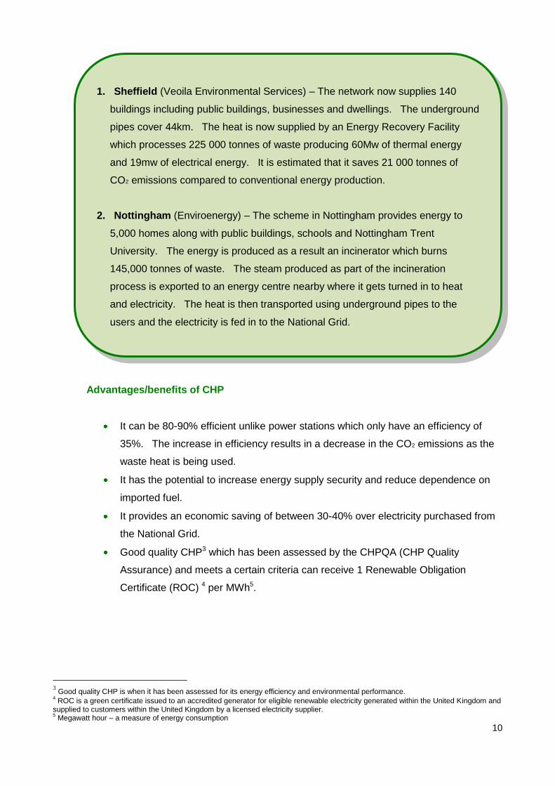
3.11 Both schemes below developed district heating networks over twenty years ago. Since
then these networks have increased in size and are successful examples of using waste to
generate heat and power in the UK.
10
Advantages/benefits of CHP
It can be 80-90% efficient unlike power stations which only have an efficiency of
35%. The increase in efficiency results in a decrease in the CO2 emissions as the
waste heat is being used.
It has the potential to increase energy supply security and reduce dependence on
imported fuel.
It provides an economic saving of between 30-40% over electricity purchased from
the National Grid.
Good quality CHP3 which has been assessed by the CHPQA (CHP Quality
Assurance) and meets a certain criteria can receive 1 Renewable Obligation
Certificate (ROC) 4 per MWh5.
3 Good quality CHP is when it has been assessed for its energy efficiency and environmental performance.
4 ROC is a green certificate issued to an accredited generator for eligible renewable electricity generated within the United Kingdom and
supplied to customers within the United Kingdom by a licensed electricity supplier. 5 Megawatt hour – a measure of energy consumption
1. Sheffield (Veoila Environmental Services) – The network now supplies 140
buildings including public buildings, businesses and dwellings. The underground
pipes cover 44km. The heat is now supplied by an Energy Recovery Facility
which processes 225 000 tonnes of waste producing 60Mw of thermal energy
and 19mw of electrical energy. It is estimated that it saves 21 000 tonnes of
CO2 emissions compared to conventional energy production.
2. Nottingham (Enviroenergy) – The scheme in Nottingham provides energy to
5,000 homes along with public buildings, schools and Nottingham Trent
University. The energy is produced as a result an incinerator which burns
145,000 tonnes of waste. The steam produced as part of the incineration
process is exported to an energy centre nearby where it gets turned in to heat
and electricity. The heat is then transported using underground pipes to the
users and the electricity is fed in to the National Grid.

11
Limitations of CHP
The insulated pipe work required to transport heat is very expensive which often
means the identification of potential sites for CHP scheme are within a limited radius
as it is not cost effective after a certain distance.
CHP schemes need to be relatively close to heat users, due to the cost of
implementing a network and the associated heat loss through the length of the
network (1 c per km);
Retro-fitting is considerably more expensive than new development due to existing
infrastructure already being in place;
There are often issues over the funding of a CHP scheme/district heating network.
There need to be a 24 hour heat demand and this has to be large enough to make
the scheme pay for itself.
There are often problems with connecting to the National Grid which can increase
the cost.
When both heat and electricity are generated the amount electricity produced
decreases compared to when only electricity is created.

12
4. Assessing the CHP potential of the 13 site options
4.1 This section of the paper contains a basic assessment of the CHP potential of the 13 sites
identified in the Waste Core Strategy Site Options Consultation (October 2009).
4.2 Each site has been considered in turn for ease of reference. For each site the following
general information is provided in a series of site schedules attached below:
Site name
Site area
Site Plan
Existing use/designation
Ownership
Existing heat users within 1km
Potential heat users within 2km
4.3 Assuming that any electricity generated at each site will be exported to the National Grid,
this paper seeks to identify if there is any scope to use the heat from the process. In
particular whether there are any existing or potential heat users on or within ‘close
proximity’ of the site. This includes industrial/employment uses, other commercial uses,
residential, public buildings, hotels/catering, retail, education and health facilities.
4.4 Ideal heat users include those with a continuous demand for heat such as certain industrial
processes, hospitals etc. Those with variable, possibly seasonal heat demand, such as
residential development are less ideal although can still be catered for e.g. through district
heating particularly where they form part of a mixed-use development for example housing,
offices and leisure facilities where there is variable heat demand throughout the day.
4.5 It is understood that modern technology means the heat from an ‘energy from waste’ facility
can be transferred up to 15km from where it is generated. However it is preferable for the
heat client to be closer to the source of the heat as heat is lost at a rate of 1 c per km. To
provide a basis for assessing the potential for CHP in Gloucestershire the locations of all
existing heat users within 1km of each of the 13 potential waste sites identified in the site
options consultation (2009) have been investigated and reported. This is because going
beyond 1km for existing properties would have led to an unmanageable number of sites
being identified. Identifying existing properties (housing, public buildings, industry etc) was

13
carried out using GIS6. The locations of 'potential' heat users within 2km of the each of the
sites was also investigated and recorded. This includes future developments that have not
yet been built but could come forward in the future such as sites that have been identified in
a Local Plan or Strategic Housing Land Availability Assessments (SHLAA) but have not yet
implemented. The site schedules for each of the thirteen site options are set out below.
4.6 There are currently investigations taking place as to the possibility of biogas produced
through the Anaerobic Digestion (AD) process being piped in to the national gas pipelines.
This is being supported by the National Grid. As such, the site schedules include
information on the distance of the site to a gas pipeline. The data was provided by Wales
and West Utilities and did not include pipelines owned by other gas transporters or private
owners. The information was given without obligation, or warranty, the accuracy thereof
cannot be guaranteed.
4.7 For each of the sites we have estimated the heat demand within the surrounding area.
The data used to estimate the heat demand was taken from an independent renewable
energy study produced by consultants ENTEC on behalf of Gloucestershire County Council
in June 20107. From this report it was calculated that the average heat demand for a typical
office/industrial unit was 92,682 kWh8 (derived using an average of the heat demand and
floor area of all of the office and industrial types set out in the ENTEC report). The average
heat demand (an average for flats and houses) for an average dwelling9 (with a floor area
of 80m²) was calculated to be 7,280 kWh.
4.8 It is important to note that these figures provide an indication of the potential only. It is a
desktop assessment based on an assumed average floorspace and heat demand. If a
developer wanted to create a district heating network it would be their responsibility to
establish accurate figures. It should also be noted that the estimated figures are for heat
demand only. We have not investigated the cost or infrastructure practicalities of
implementing a district heating network.
4.9 It should be noted that this desk top assessment does not take into account any of the
practical limitations outlined in Section 3, which would have to be considered fully prior to
implementation of a CHP/District Heating scheme.
6 Geographical Information System
7 'Gloucestershire County Council Renewable Energy Study Final Report 14 June 2010'
8 Kilowatt Hour – a measure of energy consumption
9 Roys, M. 2008, 03: Housing Space Standards: a national perspective. RIBA

14
Site 1a: Area A at Wingmoor Farm East
Site Area (ha) c. 2.5
Site Plan
Existing use/designation
Open land and buildings including Materials Recovery Facility (MRF)
Site ownership Grundon Waste Management Ltd
Approximate distance to nearest gas pipeline 0.9km - High pressure pipeline
Existing heat users within 0-1km of site
Nearby uses ESTIMATED Heat Demand
(kWh per annum)
Business properties:
There are 22 nearby businesses,
2,039,004
Residential properties:
There are approximately 1127 nearby residential properties.
8,204,560
Public buildings/other properties:
Cheltenham North Rugby Club and Cheltenham & District Clay
Club.
Data not available
Potential heat users within 0-2km of site
Site ESTIMATED Heat Demand
(kWh per annum)
Local Plan - Extension to Malvern View (2.5 ha)
Data not available

15
SHLAA site – Dean Farm, Bishops Cleeve – 2359 dwellings 17,173,520
SHLAA site – Land to north west of Cheltenham - 5000 dwellings 36,400,000
SHLAA site – Land at Homelands Farm (west of railway), Bishops
Cleeve – 550 dwellings
4,004,000
Recommendation
The initial assessment work indicates that there would be a potential demand for a heat network
within nearby existing development. However the heat network would have to be retrofitted.
There is good potential for a heat network to be included within any future development due to the
possible number of new dwellings associated with major potential development nearby.
16
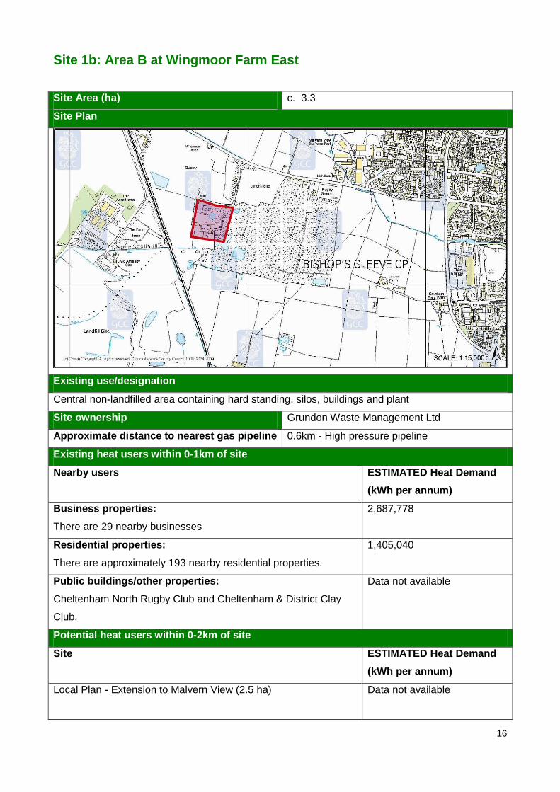
Site 1b: Area B at Wingmoor Farm East
Site Area (ha) c. 3.3
Site Plan
Existing use/designation
Central non-landfilled area containing hard standing, silos, buildings and plant
Site ownership Grundon Waste Management Ltd
Approximate distance to nearest gas pipeline 0.6km - High pressure pipeline
Existing heat users within 0-1km of site
Nearby users ESTIMATED Heat Demand
(kWh per annum)
Business properties:
There are 29 nearby businesses
2,687,778
Residential properties:
There are approximately 193 nearby residential properties.
1,405,040
Public buildings/other properties:
Cheltenham North Rugby Club and Cheltenham & District Clay
Club.
Data not available
Potential heat users within 0-2km of site
Site ESTIMATED Heat Demand
(kWh per annum)
Local Plan - Extension to Malvern View (2.5 ha)
Data not available

17
SHLAA site – Dean Farm, Bishops Cleeve – 2359 dwellings 17,173,520
SHLAA site – Land to north west of Cheltenham - 5000 dwellings 36,400,000
Recommendation
The initial assessment work indicates that there would be a potential demand for a heat network
within nearby existing development. However the heat network would have to be retrofitted.
There is good potential for a heat network to be included within any future development due to the
possible number of new dwellings associated with major potential development nearby.
18
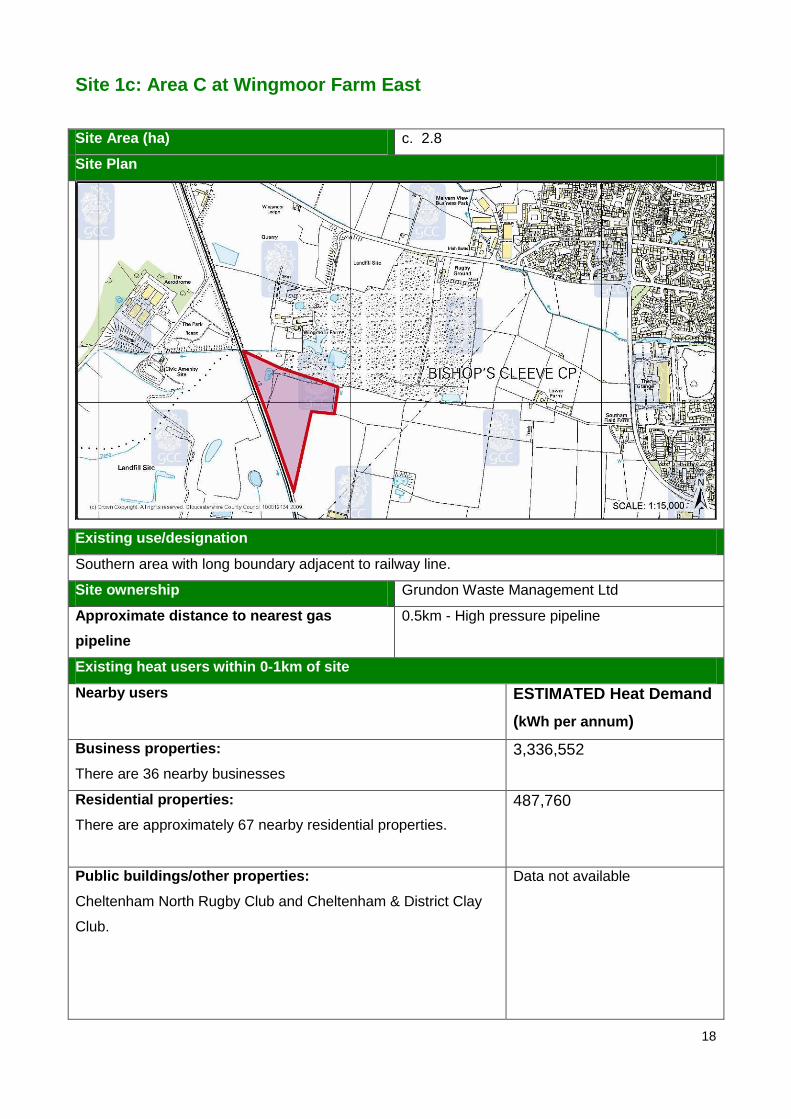
Site 1c: Area C at Wingmoor Farm East
Site Area (ha) c. 2.8
Site Plan
Existing use/designation
Southern area with long boundary adjacent to railway line.
Site ownership Grundon Waste Management Ltd
Approximate distance to nearest gas
pipeline
0.5km - High pressure pipeline
Existing heat users within 0-1km of site
Nearby users ESTIMATED Heat Demand
(kWh per annum)
Business properties:
There are 36 nearby businesses
3,336,552
Residential properties:
There are approximately 67 nearby residential properties.
487,760
Public buildings/other properties:
Cheltenham North Rugby Club and Cheltenham & District Clay
Club.
Data not available

19
Potential heat users within 0-2km of site
Site ESTIMATED Heat Demand
(kWh per annum)
Local Plan - Extension to Malvern View (2.5 ha) Data not available
SHLAA site – Dean Farm, Bishops Cleeve – 2359 dwellings 17,173,520
SHLAA site – Land to north west of Cheltenham - 5000 dwellings 36,400,000
Recommendation
The initial assessment work indicates that there would be a potential demand for a heat network
within nearby existing development. However the heat network would have to be retrofitted.
There is good potential for a heat network to be included within any future development due to the
possible number of new dwellings associated with major potential development nearby.

20
Site 2a: Area A at Wingmoor Farm West
Site Area (ha) c. 9
Site Plan
Existing use/designation
Flat agricultural land and scrubby areas.
Site ownership William Gilder
Approximate distance to nearest gas pipeline Running along site boundary – High pressure
pipeline
Existing heat users within 0-1km of site
Nearby users ESTIMATED Heat Demand
(kWh per annum)
Business properties:
There are 11 nearby businesses
1,019,502
Residential properties:
There are approximately 42 nearby residential properties.
305,760
Public buildings/other properties:
Cheltenham & District Clay Club.
Data not available
Potential heat users within 0-2km of site
Potential nearby users ESTIMATED Heat Demand
(kWh per annum)
Local Plan - Extension to Malvern View (2.5 ha)
Data not available

21
SHLAA site Deans Farm, Bishops Cleeve – 2000 dwellings 14,560,000
SHLAA site Land to the north west of Cheltenham - 5000
dwellings
36,400,000
Recommendation
The initial assessment work indicates that there would be a potential demand for a heat network
within nearby existing development. However the heat network would have to be retrofitted.
There is good potential for a heat network to be included within any future development due to the
possible number of new dwellings associated with major potential development nearby.
22
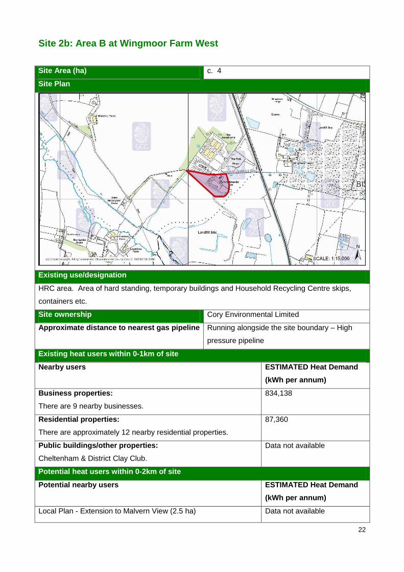
Site 2b: Area B at Wingmoor Farm West
Site Area (ha) c. 4
Site Plan
Existing use/designation
HRC area. Area of hard standing, temporary buildings and Household Recycling Centre skips,
containers etc.
Site ownership Cory Environmental Limited
Approximate distance to nearest gas pipeline Running alongside the site boundary – High
pressure pipeline
Existing heat users within 0-1km of site
Nearby users ESTIMATED Heat Demand
(kWh per annum)
Business properties:
There are 9 nearby businesses.
834,138
Residential properties:
There are approximately 12 nearby residential properties.
87,360
Public buildings/other properties:
Cheltenham & District Clay Club.
Data not available
Potential heat users within 0-2km of site
Potential nearby users ESTIMATED Heat Demand
(kWh per annum)
Local Plan - Extension to Malvern View (2.5 ha) Data not available

23
SHLAA site Deans Farm, Bishops Cleeve – 2000 dwellings 14,560,000
SHLAA site Land to the north west of Cheltenham – 5000
dwellings
36,400,000
Recommendation
The initial assessment work indicates that there would be a potential demand for a heat network
within nearby existing development. However the heat network would have to be retrofitted.
There is good potential for a heat network to be included within any future development due to the
possible number of new dwellings associated with major potential development nearby.

24
Site 2c: Area C at Wingmoor Farm West
Site Area (ha) c. 5.5
Site Plan
Existing use/designation
Gun range. Open green or rough areas interspersed with trees, thick shrubs/hedges and a few
low buildings.
Site ownership Tewkesbury Borough Council
Approximate distance to nearest gas pipeline 0.2km – High pressure pipeline
Existing heat users within 0-1km of site
Nearby users ESTIMATED Heat Demand
(kWh per annum)
Business properties:
There are 9 nearby businesses.
834,138
Residential properties:
There are approximately 9 nearby residential properties.
65,520
Public buildings/other properties:
Cheltenham North Rugby Club and the Cheltenham & District Clay
Club.
Data not available
Potential heat users within 0-2km of site
Potential nearby users ESTIMATED Heat Demand
(kWh per annum)
Local Plan - Extension to Malvern View (2.5 ha) Data not available

25
SHLAA site Deans Farm, Bishops Cleeve - 2000 dwellings 14,560,000
SHLAA site Land to the north west of Cheltenham - 5000
dwellings
36,400,000
Recommendation
The initial assessment work indicates that there would be a potential demand for a heat network
within nearby existing development. However the heat network would have to be retrofitted.
There is good potential for a heat network to be included within any future development due to the
possible number of new dwellings associated with major potential development nearby.
26
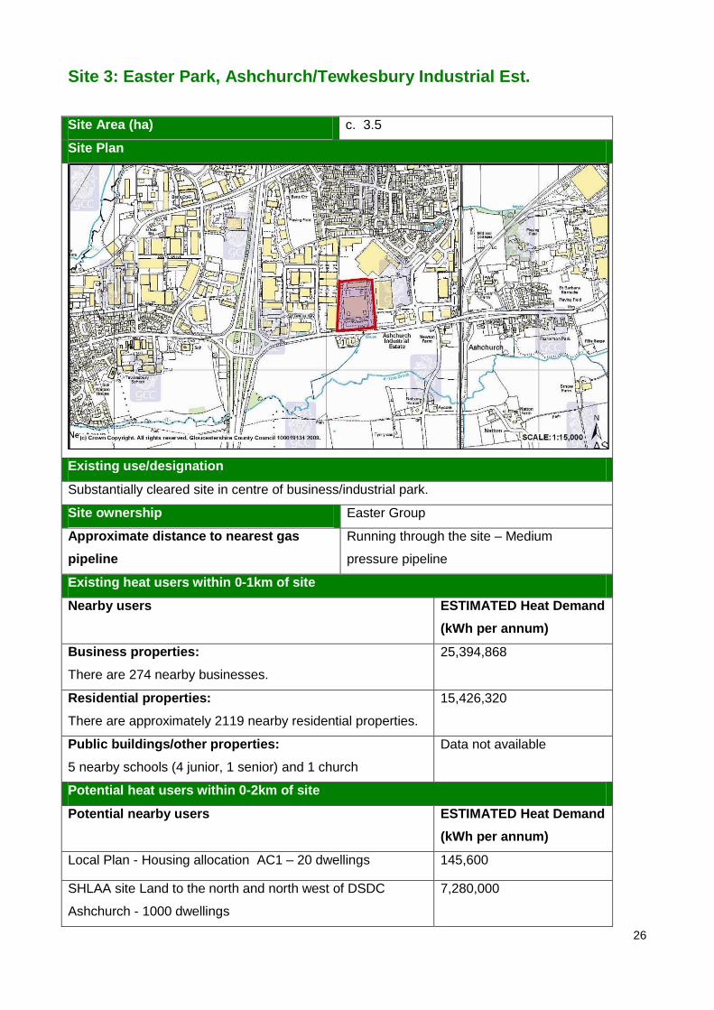
Site 3: Easter Park, Ashchurch/Tewkesbury Industrial Est.
Site Area (ha) c. 3.5
Site Plan
Existing use/designation
Substantially cleared site in centre of business/industrial park.
Site ownership Easter Group
Approximate distance to nearest gas
pipeline
Running through the site – Medium
pressure pipeline
Existing heat users within 0-1km of site
Nearby users ESTIMATED Heat Demand
(kWh per annum)
Business properties:
There are 274 nearby businesses.
25,394,868
Residential properties:
There are approximately 2119 nearby residential properties.
15,426,320
Public buildings/other properties:
5 nearby schools (4 junior, 1 senior) and 1 church
Data not available
Potential heat users within 0-2km of site
Potential nearby users ESTIMATED Heat Demand
(kWh per annum)
Local Plan - Housing allocation AC1 – 20 dwellings 145,600
SHLAA site Land to the north and north west of DSDC
Ashchurch - 1000 dwellings
7,280,000
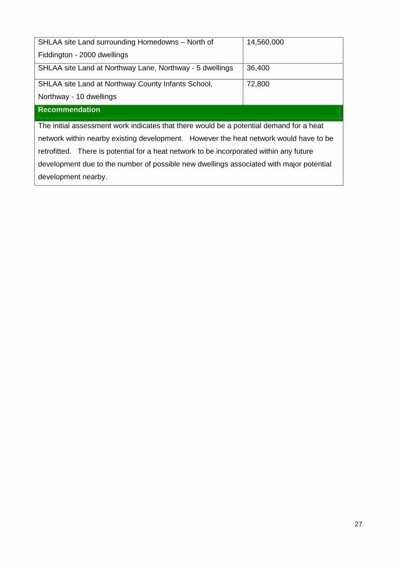
27
SHLAA site Land surrounding Homedowns – North of
Fiddington - 2000 dwellings
14,560,000
SHLAA site Land at Northway Lane, Northway - 5 dwellings 36,400
SHLAA site Land at Northway County Infants School,
Northway - 10 dwellings
72,800
Recommendation
The initial assessment work indicates that there would be a potential demand for a heat
network within nearby existing development. However the heat network would have to be
retrofitted. There is potential for a heat network to be incorporated within any future
development due to the number of possible new dwellings associated with major potential
development nearby.

28
Site 4: Javelin Park
Site Area (ha) c. 11
Site Plan
Existing use/designation
Vacant, previously developed airfield land. Benefits from planning permission for employment use.
Site ownership Gloucestershire County Council/Consi
Approximate distance to nearest gas pipeline Running along the site boundary – Low
pressure pipeline
Existing heat users within 0-1km of site
Nearby users ESTIMATED Heat Demand
(kWh per annum)
Business properties:
There are 32 nearby businesses.
2,965,824
Residential properties:
There are approximately 46 nearby residential properties.
334,880
Public buildings/other properties:
1 church
Data not available
Potential heat users within 0-2km of site
Potential nearby users ESTIMATED Heat Demand
(kWh per annum)
Local Plan - EK36 Hardwicke Former MoD Site 6 Data not available
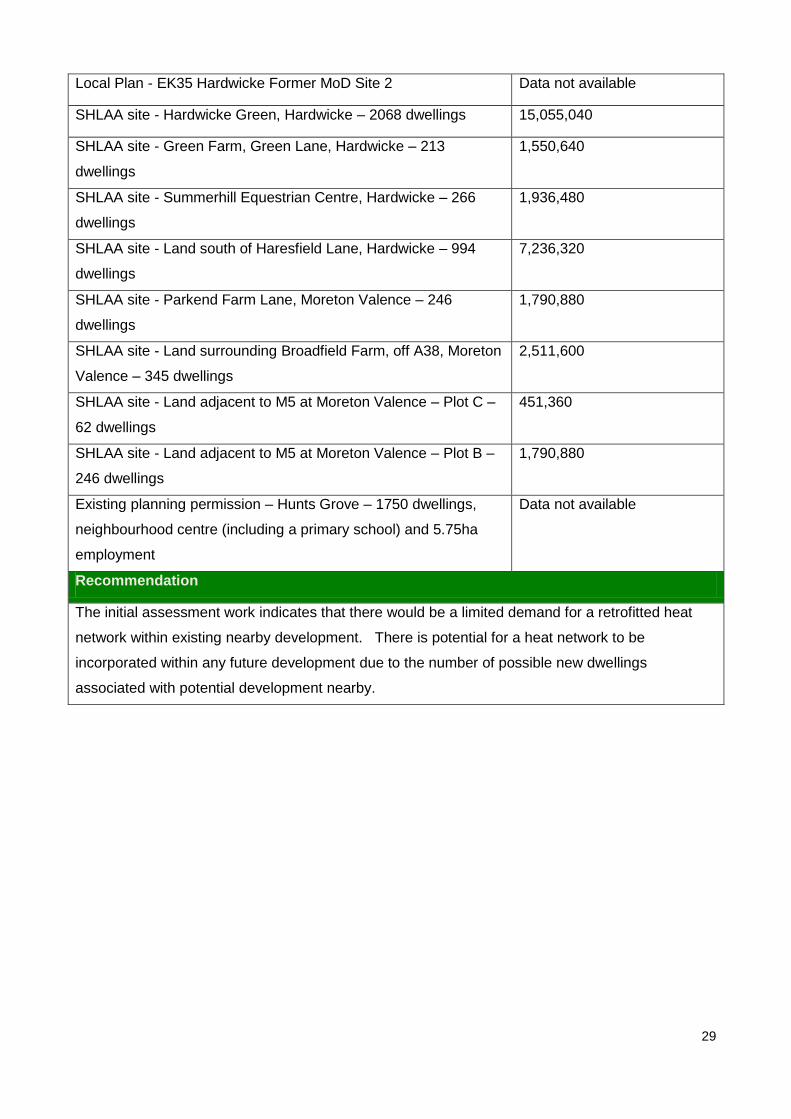
29
Local Plan - EK35 Hardwicke Former MoD Site 2 Data not available
SHLAA site - Hardwicke Green, Hardwicke – 2068 dwellings 15,055,040
SHLAA site - Green Farm, Green Lane, Hardwicke – 213
dwellings
1,550,640
SHLAA site - Summerhill Equestrian Centre, Hardwicke – 266
dwellings
1,936,480
SHLAA site - Land south of Haresfield Lane, Hardwicke – 994
dwellings
7,236,320
SHLAA site - Parkend Farm Lane, Moreton Valence – 246
dwellings
1,790,880
SHLAA site - Land surrounding Broadfield Farm, off A38, Moreton
Valence – 345 dwellings
2,511,600
SHLAA site - Land adjacent to M5 at Moreton Valence – Plot C –
62 dwellings
451,360
SHLAA site - Land adjacent to M5 at Moreton Valence – Plot B –
246 dwellings
1,790,880
Existing planning permission – Hunts Grove – 1750 dwellings,
neighbourhood centre (including a primary school) and 5.75ha
employment
Data not available
Recommendation
The initial assessment work indicates that there would be a limited demand for a retrofitted heat
network within existing nearby development. There is potential for a heat network to be
incorporated within any future development due to the number of possible new dwellings
associated with potential development nearby.

30
Site 5: Land adjacent to Quadrant Business Centre
Site Area (ha) c. 9
Site Plan
Existing use/designation
Flat overgrown previously developed land
Site ownership Ashtenne
Approximate distance to nearest gas
pipeline
Running along the site boundary – Low
pressure pipeline
Existing heat users within 0-1km of site
Nearby users ESTIMATED Heat Demand
(kWh per annum)
Business properties:
There are 155 nearby businesses.
14,365,710
Residential properties:
There are approximately 1854 nearby residential properties.
13,497,120
Public buildings/other properties:
1 church, 1 school, 3 units for the emergency centre and The
Royal British Legion,
Data not available
Potential heat users within 0-1km of site
Potential nearby users ESTIMATED Heat Demand
(kWh per annum)
Local Plan - EK35 Hardwicke Former MoD Site 2 Data not available

31
SHLAA site - RAF Quedgeley, Kingsway – 3300 dwellings 24,024,000
SHLAA site - Mayo’s Land, Quedgeley – 70 dwellings 509,600
SHLAA site - IM Distribution Centre, Naas Lane – 180
dwellings
1,310,400
SHLAA site - Lynton Fields and land to rear of – 57 dwellings 414,960
SHLAA site - Land east of Waterwells – 50 dwellings 364,000
SHLAA site - Land south of Grange Road – 220 dwellings 1,601,600
SHLAA site - Education site, Clearwell Drive, Quedgeley – 30
dwellings
218,400
SHLAA site - Land south of Gloucester, at Whaddon - 4,422
dwellings
32,192,160
SHLAA site - Sellars Farm, Hardwicke – 348 dwellings 2,533,440
SHLAA site - Mayo’s Land, Hardwick – 80 dwellings 582,400
SHLAA site - Hardwicke Green, Hardwicke – 2068 dwellings 15,055,040
SHLAA site - Green Farm, Green Lane, Hardwicke – 213
dwellings
1,550,640
SHLAA site - Summerhill Equestrian Centre – 266 dwellings 1,936,480
SHLAA site - Land at Shorn Brook Hardwicke – 86 dwellings 626,080
SHLAA site - Land south of Haresfield Lane, Hardwicke –
994 dwellings
7,236,320
SHLAA site - Land surrounding Broadfield Farm, off A38,
Moreton Valence – 345 dwellings
2,511,600
Existing planning permission – Hunts Grove – 1750
dwellings, neighbourhood centre (including a primary school)
and 5.75ha employment
Data not available
Recommendation
The initial assessment work indicates that there would is significant potential demand for a
heat network within existing nearby development. However the heat network would have to
be retrofitted. There is also good potential for a heat network to be incorporated within any
future development due to the number of possible new dwellings associated with major
potential development nearby.

32
Site 6: Land at Moreton Valence
Site Area (ha) c. 5.6
Site Plan
Existing use/designation
Former airfield land. Busy C&D and C&I waste facility. The extension area is currently farm land.
Site ownership Smiths Gloucester
Approximate Distance to nearest gas
pipeline
Running through the site – High pressure pipeline
Existing heat users within 0-1km of site
Nearby users ESTIMATED Heat Demand
(kWh per annum)
Business properties:
There are 23 nearby businesses.
2,131,686
Residential properties:
There are approximately 54 nearby residential properties.
393,120
Public buildings/other properties:
1 church
Data not available
Potential heat users within 0-2km of site
Potential nearby users ESTIMATED Heat Demand
(kWh per annum)
Local Plan - EK36 Hardwicke Former MoD Site 6
Data not available

33
SHLAA site - Land north west of Whitminster (only some of this
site falls within the 2KM buffer zone) – 1455 dwellings
10,592,400
SHLAA site - Summerhill Equestrian Centre, Hardwicke – 266
dwellings
1,936,480
SHLAA site - Hardwick Green, Hardwicke – 2068 dwellings 15,055,040
SHLAA site - Land south of Haresfield Lane, Hardwicke – 994
dwellings
5,238,380
SHLAA site - Parkend Farm Land, Moreton Valence – 246
dwellings
1,790,880
SHLAA site - Land surrounding Broadfield Farm, off A38,
Moreton Valence – 345 dwellings
2,511,600
SHLAA site - Land adjacent to M5 at Moreton Valence – Plot C
– 62 dwellings
451,360
SHLAA site - Land adjacent to M5 at Moreton Valence – Plot B
– 246 dwellings
1,790,880
Recommendation
The initial assessment work indicates that there would be a limited demand for a retrofitted heat
network within existing nearby development. There is potential for a heat network to be
incorporated within any future development due to the number of possible new dwellings
associated with potential development nearby.

34
Site 7: Land north of Railway Triangle, Gloucester
Site Area (ha) c. 5.5
Site Plan
Existing use/designation
Existing waste transfer site/aggregate business. The site also includes an area containing
other small businesses as well as redundant railway land and sidings
Site ownership Allstone Sand and Gravel Ltd
Approximate distance to nearest gas
pipeline
Running along the site boundary – Low
pressure pipeline
Existing heat users within 0-1km of site
Nearby users ESTIMATED Heat Demand
(KWh per annum)
Business properties:
There are approximately 602 nearby businesses.
55,794,564
Residential properties:
There are approximately 8027 nearby residential properties.
58,436,560
Public buildings/other properties:
These include approximately 1 hospital, 1 ambulance station,
9 schools, 4 churches, 1 police station, 1 fire station, 2
sports/leisure centres and the TA Centre. There are
approximately 30 nearby public building/other properties in
total.
Data not available

35
Potential heat users within 0-2km of site
Potential nearby users ESTIMATED Heat Demand
(kWh per annum)
Local Plan –H 2.6 Bus Depot, London Rd -35 dwellings 254,800
Local Plan – H 2.1 Part of St Michael's Square facing
Brunswick Road – 35 dwellings
254,800
Local Plan – H 2.3 Thomas Rich's car park – 30 dwellings 218,400
Local Plan – HC 18 Bakers Quay – 118 dwellings 859,040
Local Plan – MU 3 Bus Station and Market Parade (bus
station, offices, retail and housing) 25 dwellings
182,000
SHLAA site - Railway triangle (North) – 334 dwellings 2,431,520
SHLAA site - Fire Station – Eastern Avenue – 38 dwellings 276,640
SHLAA site - Former B&Q – 40 dwellings 291,200
SHLAA site - Bohanam House and adj Elmscroft Community
Centre site – 38 dwellings
276,640
SHLAA site - Hellipebs, Sisson Road – 70 dwellings 509,600
SHLAA site - Paygrove West – land off Paygrove Lane – 15
dwellings
109,200
SHLAA site - Clifton Road triangle – 65 dwellings 473,200
SHLAA site - Land at the corner of Southgate Street and
Trier Way – 12 dwellings
87,360
SHLAA site - former GWRSA social club – 20 dwellings 145,600
SHLAA site - Bus Station and Market Parade – 200 dwellings 1,456,000
SHLAA site - former Telecom House, Great Western Road –
25 dwellings
182,000
SHLAA site - Hampden Way car park – 75 dwellings 546,000
SHLAA site - Heathfields, 30 Denmark Road – 4 dwellings 29,120
SHLAA site - Land at Posy Lane, Lansdown Road and
Denmark Road – 10 dwellings
72,800
Gloucestershire Heritage Urban Regeneration Corporation
site – Railway Triangle
Data not available
Recommendation
This site has significant potential heat demand from existing nearby development including
businesses, dwellings and Gloucester Royal Hospital. However to meet this demand a

36
significant heat network would have to be retrofitted. There is potential for a heat network to
be included within any future development in particular the prospective redevelopment of the
railway triangle area.
37
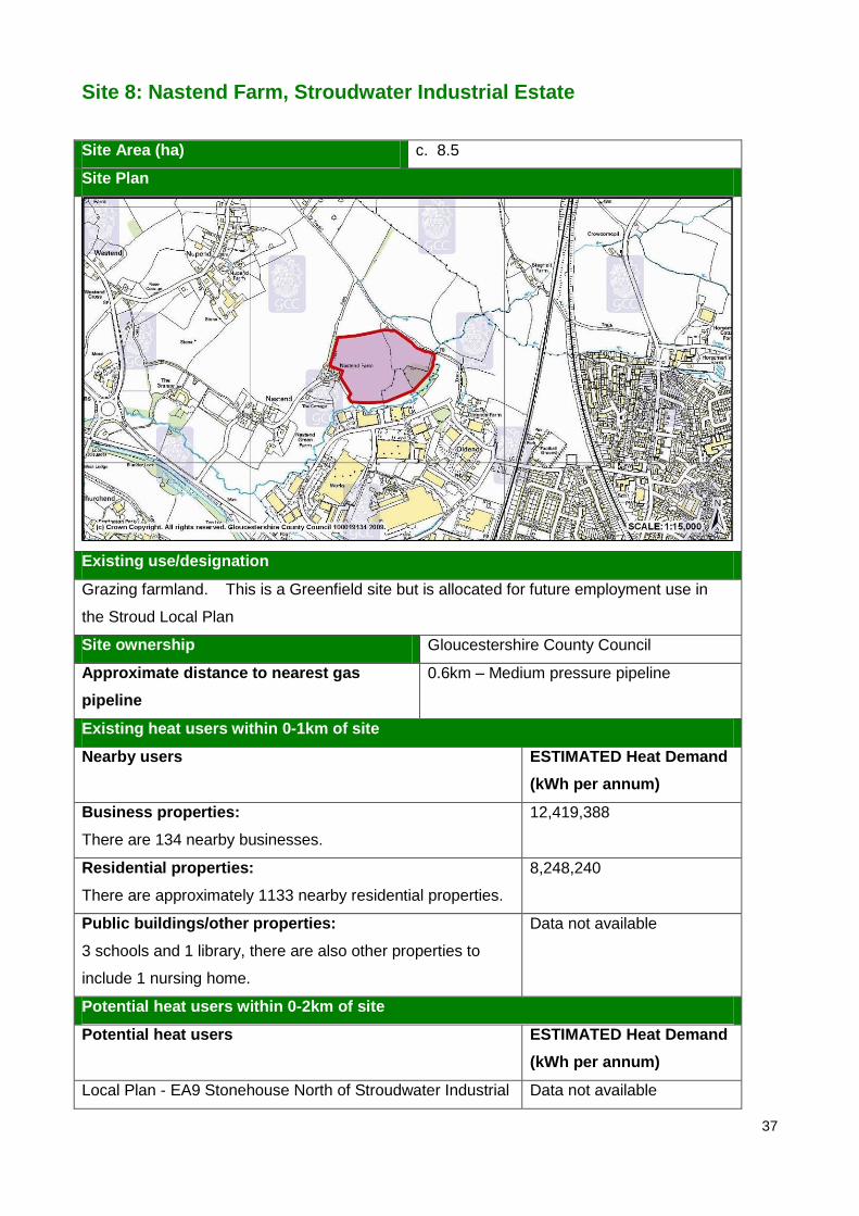
Site 8: Nastend Farm, Stroudwater Industrial Estate
Site Area (ha) c. 8.5
Site Plan
Existing use/designation
Grazing farmland. This is a Greenfield site but is allocated for future employment use in
the Stroud Local Plan
Site ownership Gloucestershire County Council
Approximate distance to nearest gas
pipeline
0.6km – Medium pressure pipeline
Existing heat users within 0-1km of site
Nearby users ESTIMATED Heat Demand
(kWh per annum)
Business properties:
There are 134 nearby businesses.
12,419,388
Residential properties:
There are approximately 1133 nearby residential properties.
8,248,240
Public buildings/other properties:
3 schools and 1 library, there are also other properties to
include 1 nursing home.
Data not available
Potential heat users within 0-2km of site
Potential heat users ESTIMATED Heat Demand
(kWh per annum)
Local Plan - EA9 Stonehouse North of Stroudwater Industrial Data not available

38
Estate 15.7ha
Local Plan - EA2 Eastington Meadow Mill, Eastington 2.2ha Data not available
Local Plan - EK2 Eastington Meadow Mill Industrial Estate Data not available
Local Plan - EK4 Stonehouse Bonds Mill Industrial Estate,
Bristol Road
Data not available
Local Plan - EK5 Stonehouse Upper Mills Industrial Estate,
Bristol Road
Data not available
Local Plan - Hg15C Garage and plumbers’ yard, Gloucester
Road - 20 dwellings
145,600
SHLAA site - Land west of Stonehouse – 3805 dwellings 27,700,400
SHLAA site - Land north of Eastington – 1567 dwellings 11,407,760
SHLAA site - Land to the rear of Regent Street, Stonehouse
– 28 dwellings
203,840
SHLAA site - Pearcroft Road, Stonehouse – 18 dwellings 131,040
SHLAA site - Pearcroft Road, Stonehouse – 85 dwellings 618,800
SHLAA site - Paper Mill, Lower Mills, Stonehouse – 55
dwellings
400,400
SHLAA site - Cotswold Green, Stonehouse – 28 dwellings 203,840
SHLAA site - Former goods yard and branch line,
Stonehouse – 71 dwellings
516,880
SHLAA site - Willow Farm, Bristol Road, Stonehouse – 95
dwellings
691,600
SHLAA site - Land to the east of Bramble Lane, Stonehouse
54 dwellings
393,120
SHLAA site - Land between Millend Lane and Bath Road,
Eastington – 306 dwellings
2,227,680
SHLAA site - Site of former Ship Inn, Stonehouse – 12
dwellings
87,360
SHLAA site - The Shubberies School, Oldends Lane,
Stonehouse – 44 dwellings
320,320
SHLAA site - Land at Kimmins Road, Stonehouse – 10
dwellings
72,800
SHLAA site - Land opposite Avenue Terrace, Stonehouse –
226 dwellings
164,280
SHLAA site - Land west of Bridgend House, Bridgend,
Stonehouse – 62 dwellings
451,360
39
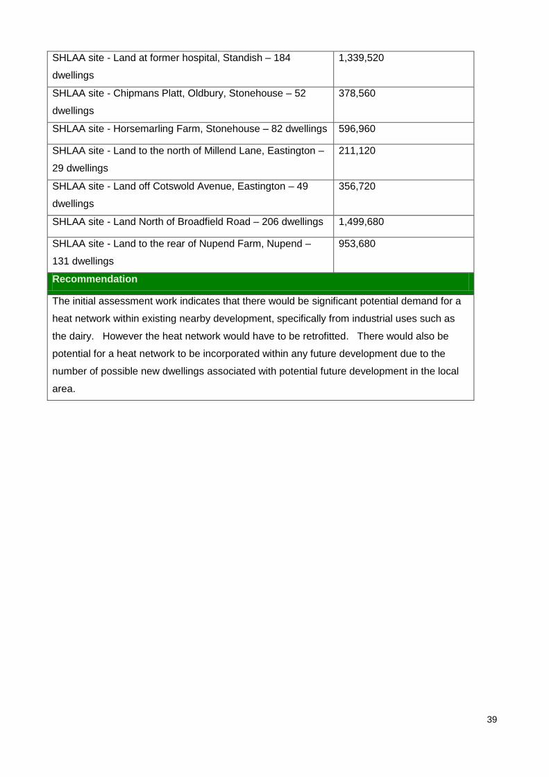
SHLAA site - Land at former hospital, Standish – 184
dwellings
1,339,520
SHLAA site - Chipmans Platt, Oldbury, Stonehouse – 52
dwellings
378,560
SHLAA site - Horsemarling Farm, Stonehouse – 82 dwellings 596,960
SHLAA site - Land to the north of Millend Lane, Eastington –
29 dwellings
211,120
SHLAA site - Land off Cotswold Avenue, Eastington – 49
dwellings
356,720
SHLAA site - Land North of Broadfield Road – 206 dwellings 1,499,680
SHLAA site - Land to the rear of Nupend Farm, Nupend –
131 dwellings
953,680
Recommendation
The initial assessment work indicates that there would be significant potential demand for a
heat network within existing nearby development, specifically from industrial uses such as
the dairy. However the heat network would have to be retrofitted. There would also be
potential for a heat network to be incorporated within any future development due to the
number of possible new dwellings associated with potential future development in the local
area.
40
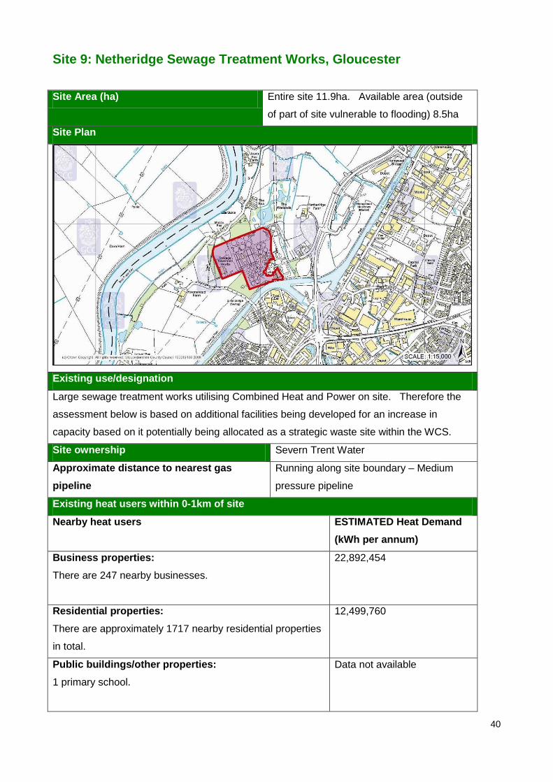
Site 9: Netheridge Sewage Treatment Works, Gloucester
Site Area (ha) Entire site 11.9ha. Available area (outside
of part of site vulnerable to flooding) 8.5ha
Site Plan
Existing use/designation
Large sewage treatment works utilising Combined Heat and Power on site. Therefore the
assessment below is based on additional facilities being developed for an increase in
capacity based on it potentially being allocated as a strategic waste site within the WCS.
Site ownership Severn Trent Water
Approximate distance to nearest gas
pipeline
Running along site boundary – Medium
pressure pipeline
Existing heat users within 0-1km of site
Nearby heat users ESTIMATED Heat Demand
(kWh per annum)
Business properties:
There are 247 nearby businesses.
22,892,454
Residential properties:
There are approximately 1717 nearby residential properties
in total.
12,499,760
Public buildings/other properties:
1 primary school.
Data not available

41
Potential heat users within 0-2km of site
Potential heat users ESTIMATED Heat Demand
(kWh per annum)
SHLAA site - former oil storage depot, Hempsted – 100
dwellings
728,000
SHLAA site - Industrial estate, Secunda Way – 12 dwellings 87,360
SHLAA site - Travis Perkins, Secunda Way – 142 dwellings 1,033,760
SHLAA site - Griggs Timber, Bristol Road – 12 dwellings 87,360
SHLAA site - Rear of 67-75 Milton Avenue, Podsmead – 45
dwellings
327,600
SHLAA site - Former Hempsted gas works – 225 dwellings 1,638,000
SHLAA site - Education site, Clearwell Drive, Quedgeley –
30 dwellings
218,400
SHLAA site - Blackbridge Allotments & playing field, Stroud
Road – 220 dwellings
1,601,600
SHLAA site - RAF Quedgeley, Kingsway – 3300 dwellings 24,024,000
SHLAA site - Land between Canal & Bristol Road – 200
dwellings
1,456,000
Recommendation
The initial assessment work indicates that there is would be significant potential demand for
a heat network within existing nearby development. However the heat network would have
to be retrofitted. There is potential for a heat network to be included within any future
development due to the possible number of new dwellings associated with potential future
development in the local area.

42
Site 10: The Park, Wingmoor Farm West
Site Area (ha) c. 6.8
Site Plan
Existing use/designation
An industrial estate with existing waste management uses. In the centre of the site there
are 4 former RAF buildings/hangers.
Site ownership Wellington Park Properties
Approximate distance to nearest gas
pipeline
Running through the site – High pressure
pipeline
Existing heat users within 0-1km of site
Nearby heat users ESTIMATED Heat Demand
(kWh per annum)
Business properties:
There are 13 businesses
1,204,866
Residential properties:
There are approximately 23 nearby residential properties in
total.
167,440
Public buildings/other properties:
There are no nearby public buildings
Data not available
Potential heat users within 0-2km of site
Potential nearby users ESTIMATED Heat Demand
(kWh per annum)
Local Plan - Extension to Malvern View (2.5 ha) Data not available

43
SHLAA site Deans Farm, Bishops Cleeve - 2000 dwellings 14,560,000
SHLAA site Land to north west of Cheltenham - 5000
dwellings
36,400,000
Recommendation
The initial assessment work indicates that there would be a demand for a heat network
within the existing development. However the heat network would have to be retrofitted.
There is good potential for a heat network to be included within any future development due
to the possible number of new dwellings associated with major potential development
nearby.
44
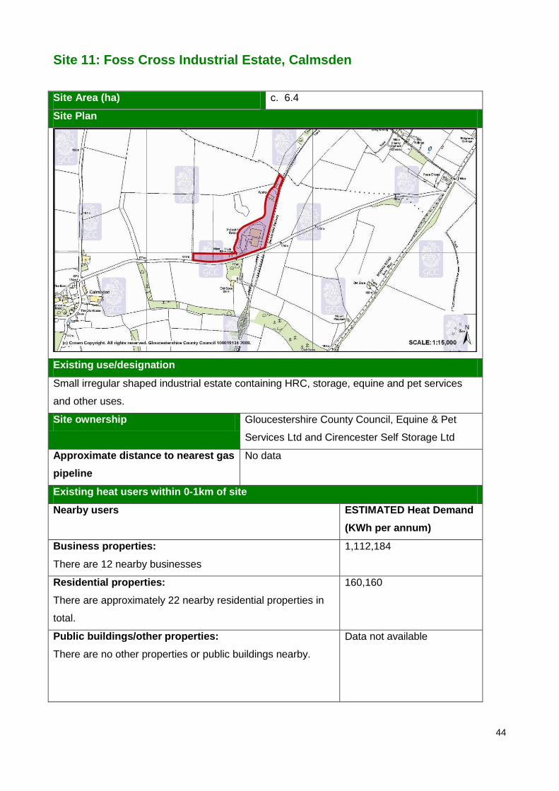
Site 11: Foss Cross Industrial Estate, Calmsden
Site Area (ha) c. 6.4
Site Plan
Existing use/designation
Small irregular shaped industrial estate containing HRC, storage, equine and pet services
and other uses.
Site ownership Gloucestershire County Council, Equine & Pet
Services Ltd and Cirencester Self Storage Ltd
Approximate distance to nearest gas
pipeline
No data
Existing heat users within 0-1km of site
Nearby users ESTIMATED Heat Demand
(KWh per annum)
Business properties:
There are 12 nearby businesses
1,112,184
Residential properties:
There are approximately 22 nearby residential properties in
total.
160,160
Public buildings/other properties:
There are no other properties or public buildings nearby.
Data not available

45
Potential heat users within 0-2km of site
Potential nearby users ESTIMATED Heat Demand
(kWh per annum)
N/A N/A
Recommendation
This site would only be suitable for a small scale CHP/district heating network due to the
limited number of existing properties in the vicinity of the site and the lack of planned
development nearby. Any scheme would have to be retrofitted.
46
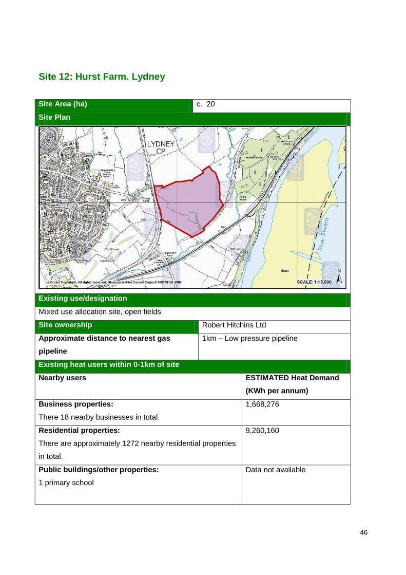
Site 12: Hurst Farm. Lydney
Site Area (ha) c. 20
Site Plan
Existing use/designation
Mixed use allocation site, open fields
Site ownership Robert Hitchins Ltd
Approximate distance to nearest gas
pipeline
1km – Low pressure pipeline
Existing heat users within 0-1km of site
Nearby users ESTIMATED Heat Demand
(KWh per annum)
Business properties:
There 18 nearby businesses in total.
1,668,276
Residential properties:
There are approximately 1272 nearby residential properties
in total.
9,260,160
Public buildings/other properties:
1 primary school
Data not available

47
Potential heat users within 0-2km of site
Potential nearby users ESTIMATED Heat Demand
(kWh per annum)
Local Plan - Lydney 1 – Mixed use – 1250 dwellings and
9ha employment
Data not available
Local Plan - Lydney 5 – Housing – Kings Building (Mill St
South) – 18 dwellings
131,040
Local Plan - Lydney 6 – Housing – Hill Street – 10 dwellings 72,800
Local Plan - Lydney 8 – Mead Lane – B1, B2, B8 Data not available
Local Plan - Lydney 9 – rear of Pine End Works, Harbour
Lane – B1, B2, B8
Data not available
SHLAA site – Cambourne Place - 33 dwellings 240,240
SHLAA site – Former Council Offices, High Street -14
dwellings
101,920
SHLAA site – Severnbanks School – 74 dwellings 538,720
SHLAA site – Highfield Road – 47 dwellings 342,160
SHLAA site – Land at Primrose Hill, Springfield Road – 8
dwellings
58,240
SHLAA site – Augustus Way, Court Road, Allaston – 196
dwellings
1,426,880
SHLAA site – Allaston Road – 9 dwellings 65,520
Recommendation
The initial assessment work indicates that there would be a potential demand for a heat
network within existing nearby development. However the heat network would have to be
retrofitted. There is limited potential for a heat network to be included within any future
development due to the relatively small number of possible new dwellings associated with
future development in the local area.
48
Site 13: Land at Lydney Industrial Estate
Site Area (ha) c. 28
Site Plan
Existing use/designation
Industrial estate and other land.
Site ownership Beachley Property Ltd
Approximate distance to nearest gas
pipeline
Running through the site – Low pressure
pipeline
Existing heat users within 0-1km of site
Nearby users ESTIMATED Heat Demand
(kWh per annum)
Business properties:
There are approximately 39 nearby businesses in total.
3,614,598
Residential properties:
There are approximately 1156 nearby residential properties
in total.
8,415,680
Public buildings/other properties:
1 church
Data not available
Potential heat users within 0-2km of site
Potential nearby users ESTIMATED Heat Demand
(KWh per annum)
Local Plan - Lydney 1 – Mixed use – 1250 dwellings and 9ha
employment
Data not available
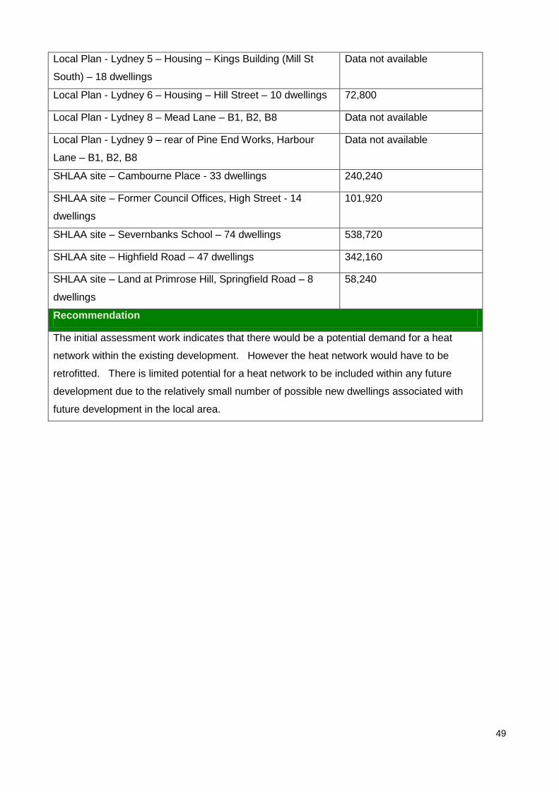
49
Local Plan - Lydney 5 – Housing – Kings Building (Mill St
South) – 18 dwellings
Data not available
Local Plan - Lydney 6 – Housing – Hill Street – 10 dwellings 72,800
Local Plan - Lydney 8 – Mead Lane – B1, B2, B8 Data not available
Local Plan - Lydney 9 – rear of Pine End Works, Harbour
Lane – B1, B2, B8
Data not available
SHLAA site – Cambourne Place - 33 dwellings 240,240
SHLAA site – Former Council Offices, High Street - 14
dwellings
101,920
SHLAA site – Severnbanks School – 74 dwellings 538,720
SHLAA site – Highfield Road – 47 dwellings 342,160
SHLAA site – Land at Primrose Hill, Springfield Road – 8
dwellings
58,240
Recommendation
The initial assessment work indicates that there would be a potential demand for a heat
network within the existing development. However the heat network would have to be
retrofitted. There is limited potential for a heat network to be included within any future
development due to the relatively small number of possible new dwellings associated with
future development in the local area.

50
Appendix 1
Sources of Further Information
Publications
Energy Act 2008
Integrated Energy – The role of CHP and district heating in our energy future – CHPA
(2010)
Meeting the Energy Challenge – A White Paper on Energy (2007)
PPS1 – Delivering Sustainable Development (2005)
PPS22 – Renewable Energy (2004)
Review of PPS22 (2010)
Draft PPS: Planning for a Low Carbon Future in a Changing Climate (2010)
The UK Renewable Energy Strategy (July 2009)
Warm Homes, Greener Homes – A Strategy for Household Energy Management (March
2010)
Waste Strategy for England (May 2007)
Websites
CHP focus – www.chp.decc.gov.uk/cms
Combined Heat and Power Association - www.chpa.co.uk
DEFRA - www.defra.gov.uk/environment/waste
The official information portal on Anaerobic Digestion - www.biogas-info.co.uk
UK heat map – www.chp.decc.gov.uk/heatmap/

51
Minerals & Waste Planning Policy Environment Directorate
Gloucestershire County Council Shire Hall Gloucester GL1 2TH
www.gloucestershire.gov.uk
December 2010