technical analysis of commercially hosted optical … · technical analysis of commercially hosted...
TRANSCRIPT
Technical analysis of commercially hosted optical payloads for enhanced SSA
Jonathan D. Lowe Analytical Graphics, Inc., Exton, Pennsylvania, 19341. Email:[email protected]
David A. Vallado Center for Space Standards and Innovation, Colorado Spring, Colorado, 80920.
Email:[email protected] Bob Hall
Analytical Graphics, Inc., Exton, Pennsylvania, 19341. Email:[email protected]
ABSTRACT
A proof-of-concept analysis is conducted to demonstrate the benefits of combining observations from commercially hosted optical payloads in Geostationary Earth Orbit (GEO) with data from traditional ground-based tracking systems. Several notional combinations of host orbits, ground tracking, hosted sensor scan capability and scheduling patterns are examined. Particular attention is given to the potential Space Situational Awareness (SSA) benefits realized by combining the space-based data with the ground network data.
1. BACKGROUND Geostationary orbit determination can be particularly difficult for uncooperative satellites [1]. Ground sensor visibility is often limited due to the nature of the sensor (many of which are optical) and a limited number of observations are collected. MIT Lincoln Labs successfully operated the Midcourse Space Experiment’s Space Based Vehicle (MSX/SBV) sensor to provide space-based optical observations to AFSPC for processing of GEO space objects for many years [2]. The resulting GEO orbits witnessed a large improvement in accuracy. There are several US Air Force initiatives to introduce future Space Based Space Surveillance (SBSS) systems into the USAF Space Surveillance Network (SSN) sensor mix, but none are operational to date. Commercial Geostationary Earth Orbit (GEO) satellite Owner-Operators and US Government organizations are currently investigating novel methods to improve the Space Situational Awareness for the GEO belt. One method includes the addition of secondary hosted payloads (HPs) on commercial GEO communications platforms. These payloads would have one or more optical sensors for tracking Resident Space Objects (RSOs). These trackers have significant advantages over ground-based trackers, including proximity and persistent views not limited by weather conditions. However, no such payloads have yet flown in GEO and no specific architecture of sensor tasking or data processing has been established. This study aims to identify some of the relevant issues in such a system and quantify how they impact the orbit uncertainty of the RSOs through a proof-of-concept trade study. The larger goal is to setup a framework within which various options can be explored in a realistic fashion.
2. TRADE STUDY DEFINITION All analysis was performed by simulating realistic tracking data and performing orbit determination using AGI’s Orbit Determination Toolkit (ODTK) and Satellite Tool Kit (STK). ODTK consists of a sequential filter (an extended Kalman filter with customized process noise), an optimal sequential smoother, and a simulator. Of particular relevance is the simulator, which attempts to produce a set of realistic measurements by deviating satellite states, tracking system measurement biases, environmental factors (e.g. atmospheric density) and adding measurement noise, all within the user-defined statistical parameters for each value. For this study, all parameters except the satellite orbit state were perturbed when creating sample tracking data. Tests were run to limit the observations in cases where the sensor had continuous or long periods when the RSO objects were visible. The design for this study included five RSOs in various orbits, several sensor networks, and a few hosted payloads. The notional geometry is shown in Fig. 1. with two host satellites located at approximately 50E and 80E.

Fig 1. Depiction of notional Hosted Payload architecture
Multiple tracking stations and sensor networks are modeled including relevant statistical characteristics of their measurements, detailed in Tab. 1. Each pass for a given tracking strand is modeled by first computing the window of time during which certain basic visibility constraints are met. Then a pass is chosen from within those intervals that conformed to that tracking strands specified methodology. Next a selected tracking schedule is then processed in the ODTK simulator to generate the observations. The simulated observations are processed together in the filter and smoother. Finally, various output reports and plots are generated.
Tab. 1. Summary of tracking data properties and scheduling
2.1 Visibility Constraints The following constraints were applied to the STK scenario simulation. These constraints are notional and specific parameters can easily be set within the existing framework.
2.1.1 Object lighting Ground stations must be in full shadow (i.e. after local twilight) and tracked satellites must not be in eclipse. 2.1.2 Solar lighting angle The tracker-RSO-Sun angle must be 90° or less, for both ground- and space-based trackers. The lighting constraints were simplified to capture first-order effects and more detailed investigation will be the topic of future study.
Network Trackers Meas. Types Meas.
accuracy Pass
length Meas. rate
Pass schedule
SSN Diego Garcia, Moron
Right Ascension Declination
0.5 arcSec 3 min 30 sec 1 pass / X days (variable). Stations alternate passes. Passes randomly placed within constrained intervals.
OO Cyprus, Perth, Hong Kong
Range Azimuth Elevation
Range: 5 m Az: 0.03° El: 0.02°
15 min 30 sec
1 randomly placed pass every 6 hrs. Simultaneous obs from each station.
HP HP1, HP2 SB Right Ascension, SB Declination
10 arcSec (variable)
~12 hr (variable)
60 sec 1 continuous pass spanning each constrained interval.
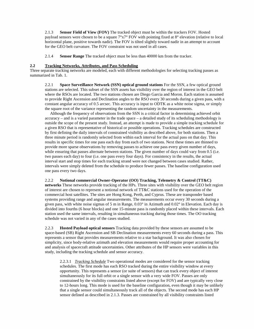
2.1.3 Sensor Field of View (FOV) The tracked object must be within the trackers FOV. Hosted payload sensors were chosen to be a square 7°x7° FOV with pointing fixed at 8° elevation (relative to local horizontal plane, positive towards nadir). The FOV is tilted slightly toward nadir in an attempt to account for the GEO belt curvature. The FOV constraint was not used in all cases. 2.1.4 Sensor Range The tracked object must be less than 40000 km from the tracker.
2.2 Tracking Networks, Attributes, and Pass Scheduling Three separate tracking networks are modeled, each with different methodologies for selecting tracking passes as summarized in Tab. 1.
2.2.1 Space Surveillance Network (SSN) optical ground stations For the SSN, a few optical ground stations are selected. This subset of the SSN assets has visibility over the region of interest in the GEO belt where the RSOs are located. The two stations chosen are Diego Garcia and Moron. Each station is assumed to provide Right Ascension and Declination angles to the RSO every 30 seconds during a given pass, with a constant angular accuracy of 0.5 arcsec. This accuracy is input to ODTK as a white noise sigma, or simply the square root of the variance representing the random uncertainty in the measurements. Although the frequency of observations from the SSN is a critical factor in determining achieved orbit accuracy – and is a varied parameter in the trade space – a detailed study of its scheduling methodology is outside the scope of the present study. Instead, an attempt is made to provide a simple tracking schedule for a given RSO that is representative of historical or possible operations. Tracking schedules are constructed by first defining the daily intervals of constrained visibility as described above, for both stations. Then a three minute period is randomly selected from within each interval for the actual pass on that day. This results in specific times for one pass each day from each of two stations. Next these times are thinned to provide more sparse observations by removing passes to achieve one pass every given number of days, while ensuring that passes alternate between stations. The given number of days could vary from 0.5 (i.e. two passes each day) to four (i.e. one pass every four days). For consistency in the results, the actual interval start and stop times for each tracking strand were not changed between cases studied. Rather, intervals were simply deleted from the schedule to produce fewer passes. The baseline configuration used one pass every two days. 2.2.2 Notional commercial Owner-Operator (OO) Tracking, Telemetry & Control (TT&C) networks These networks provide tracking of the HPs. Three sites with visibility over the GEO belt region of interest are chosen to represent a notional network of TT&C stations used for the operation of the commercial host satellites. The sites are Hong Kong, Perth, and Cyprus. These are transponder based systems providing range and angular measurements. The measurements occur every 30 seconds during a given pass, with white noise sigmas of 5 m in Range, 0.03° in Azimuth and 0.02° in Elevation. Each day is divided into fourths (6 hour blocks) and one 15-minute pass is randomly placed within these intervals. Each station used the same intervals, resulting in simultaneous tracking during those times. The OO tracking schedule was not varied in any of the cases studied. 2.2.3 Hosted Payload optical sensors Tracking data provided by these sensors are assumed to be space-based (SB) Right Ascension and SB Declination measurements every 60 seconds during a pass. This represents a sensor that provides measurements relative to a star background. It was also chosen for simplicity, since body-relative azimuth and elevation measurements would require proper accounting for and analysis of spacecraft attitude uncertainties. Other attributes of the HP sensors were variables in this study, including the tracking schedule and sensor accuracy.
2.2.3.1 Tracking Schedule Two operational modes are considered for the sensor tracking schedules. The first mode has each RSO tracked during the entire visibility window at every opportunity. This represents a sensor (or suite of sensors) that can track every object of interest simultaneously for its full orbit or a single sensor with a very wide FOV. Passes are only constrained by the visibility constraints listed above (except for FOV) and are typically very close to 12-hours long. This mode is used for the baseline configuration, even though it may be unlikely that a single sensor could simultaneously track all of the objects. The second mode has each HP sensor defined as described in 2.1.3. Passes are constrained by all visibility constraints listed

above. Pass length is dependent on RSO inclination, eccentricity, and distance along the GEO belt from the HP. The duration of a given pass varies significantly between RSOs, from no change at all (RSO orbit is completely contained within the FOV) to reduction by 85% compared to the first case. 2.2.3.2 Sensor Accuracy Measurements from the hosted optical sensor have a white noise sigma of 10, 5, or 1 arcsec. The baseline accuracy is 10 arcsec.
2.3 Multiple Satellite Solutions (MSS) Processing observations for multiple satellites simultaneously in the same filter is known to produce significantly improved results because the estimation process can better model the sensor statistics and any correlations in the system. However, for hosted payload architectures, this operational mode would, by definition, require access to and use of direct tracking data from various distinct organizations (e.g. US Government and commercial Owner-Operators) in a single data processing center. This may or may not be feasible. However, an effort is made to understand the benefits of possible combinations of multiple satellite solutions and drawbacks with respect to RSO orbit knowledge. In every case in this study, tracking data of the RSOs from the HPs is available to the filter and is combined with other measurements. Cases where RSO orbital estimates are generated independently by the HPs and then supplied as a catalog (i.e. ephemeris data) to other tracking systems are not considered. The primary reason for omitting those cases is that on the GEO belt even two HPs with overlapping coverage tend to create geometrically unobservable systems and orbital estimates created from only those trackers will be degenerate or quickly diverge. Some amount of tracking with different geometries, such as SSN ground tracking, is necessary to obtain a reliable solution. Several combinations of data and tracking for the HP are considered.
2.3.1 Host orbits provided by reference ephemeris In the simplest case, the orbit of the host satellites are given as a reference ephemeris, not including covariance information. Their states are not estimated by the filter. This has a similar effect to assuming perfect orbit knowledge of the host satellites and will result in unrealistically accurate “best case” RSO orbits. This is useful as a baseline for comparative purposes and is used as the baseline MSS mode. The SSN is used only to track the RSOs. Tracking by the OO network is not directly considered, although it would ultimately produce the reference ephemeris. Note that while useful as a comparison baseline, this setup would not give meaningful RSO covariance information in an operational system. Including the orbit accuracy of the HP satellite is critical to the success of the overall process. There it is recommended to model the uncertainty of the HP satellite use a reference ephemeris with covariance or assume a fixed uncertainty in the HP position. 2.3.2 Hosts tracked by OO and SSN and processed with SSN tracking of RSOs The SSN is used to track both host satellites and the RSOs. Those observations are processed in the same filter as the OO tracking of the host satellites. 2.3.3 Hosts tracked by OO network only but processed with SSN tracking of RSOs This configuration includes tracking of the HPs by the OO networks in the same filter as SSN tracking of the RSOs only. 2.3.4 Two HPs available These configurations use both HPs. 2.3.5 One HP available These configurations use only a single HP located at approximately 50E.
2.4 Separation of HPs Along GEO Belt A hosted payload located immediately adjacent to an RSO along the GEO belt will have no observability of its in-track position or velocity. As the HP moves away from the RSO along the belt, some in-track component will become visible. The difference in Longitude of Ascending Node (LAN) between the two HPs is varied from 30° to 60°. 2.5 Ground Network Only Configurations A number of other cases which used ground tracking only (e.g. no HP tracking of RSOs is considered) are computed in order to produce a fixed set of simulated observations for use in the trade study. These are included for reference.
2.5.1 Host satellites tracked by OO network only This uses the OO pass scheduling as described in section 2.2.2, but these measurements and the host satellites are the only ones processed by the filter. 2.5.2 Host satellites tracked by OO network and SSN; RSOs tracked by SSN Here only ground tracking is used in a MSS configuration. Pass scheduling for both networks is as mentioned above and the SSN tracks at rate of two passes per day. This may represent a very aggressive tracking schedule using current tracking assets. 2.5.3 SSN only tracks RSOs and hosts No OO tracking is used. SSN passes can be from two passes per day to one pass every two days.
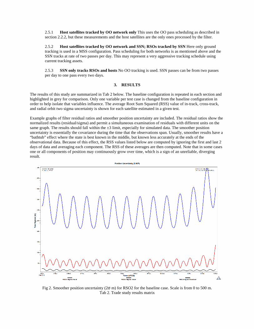
3. RESULTS The results of this study are summarized in Tab 2 below. The baseline configuration is repeated in each section and highlighted in grey for comparison. Only one variable per test case is changed from the baseline configuration in order to help isolate that variables influence. The average Root Sum Squared (RSS) value of in-track, cross-track, and radial orbit two sigma uncertainty is shown for each satellite estimated in a given test. Example graphs of filter residual ratios and smoother position uncertainty are included. The residual ratios show the normalized results (residual/sigma) and permit a simultaneous examination of residuals with different units on the same graph. The results should fall within the ±3 limit, especially for simulated data. The smoother position uncertainty is essentially the covariance during the time that the observations span. Usually, smoother results have a “bathtub” effect where the state is best known in the middle, but known less accurately at the ends of the observational data. Because of this effect, the RSS values listed below are computed by ignoring the first and last 2 days of data and averaging each component. The RSS of these averages are then computed. Note that in some cases one or all components of position may continuously grow over time, which is a sign of an unreliable, diverging result.
Fig 2. Smoother position uncertainty (2σ m) for RSO2 for the baseline case. Scale is from 0 to 500 m.
Tab 2. Trade study results matrix

Scenario Notes GE
OD
SS
pas
ses
/ X
day
HP
1 us
ed
HP
2 us
ed
HP
ref
ephe
m
OO
HP
trac
kin
g
GE
OD
SS
HP
trac
king
Ful
l Tra
ckin
g
Fixe
d FO
V
LA
N (
deg)
mea
s ac
c (a
rcS
ec)
RSO1 RSO2 RSO3 RSO4 RSO5 HP1 HP2
Baseline configuration 2 x x x x 30 10 110.1 384.6 274.2 380.0 216.0
SSN schedule trade,
One pass every 1 day 1 x x x x 30 10 110.0 376.0 273.6 386.3 214.0
One pass every 2 days (baseline) 2 x x x x 30 10 110.1 384.6 274.2 380.0 216.0
One pass every 3 days 3 x x x x 30 10 110.3 387.8 274.3 381.0 216.4
One pass every 4 days 4 x x x x 30 10 110.3 388.6 274.3 381.9 216.6
Multi-satellite solutions (MSS) trade
HP ephemeris (2 HP) (baseline) 2 x x x x 30 10 110.1 384.6 274.2 380.0 216.0
SSN tracks RSOs and 2 HPs 2 x x x x x 30 10 163.9 400.6 294.0 394.4 245.3 74.6 75.6
SSN only tracks RSOs (2 HPs) 2 x x x x 30 10 164.0 401.0 295.2 394.5 245.4 74.7 75.7
SSN tracks RSOs and 1 HP 2 x x x x 30 10 402.9 816.6 700.7 938.6 1033.5 92.8
SSN only tracks RSOs (1 HP) 2 x x x 30 10 408.0 808.8 697.1 935.5 1030.1 93.2
HP ephemeris (1 HP) 2 x x x 30 10 377.7 802.1 682.0 923.4 1017.0
Hosted Payload tracking trade
Full tracking of all RSOs (baseline) 2 x x x x 30 10 110.1 384.6 274.2 380.0 216.0
Fixed sensor FOV 2 x x x x 30 10 601.8 407.8 408.7 401.4 230.0
LAN separation trade
LAN separation 30 deg (baseline) 2 x x x x 30 10 110.1 384.6 274.2 380.0 216.0
LAN separation 60 deg 2 x x x x 60 10 324.9 624.6 618.2 632.6 552.0
HP measurement accuracy trade
10 arcSec (baseline) 2 x x x x 30 10 110.1 384.6 274.2 380.0 216.0
5 arcSec 2 x x x x 30 5 60.6 205.0 145.2 204.9 114.5
1 arcSec 2 x x x x 30 1 17.8 46.6 32.4 48.0 25.9
Other configurations for reference only
HP sats: OO tracking only - x 93.8 89.5
HP sats: OO and SSN tracking, RSOs SSN only 0.5 x x 3774 3434 3751 2919 2676 89.6 86.7
SSN tracks RSOs & HPs, 2 passes every 1 day 0.5 x 3885 3482 3912 2971 2743 935 1123
SSN tracks RSOs & HPs, 1 pass every 1 day 1 x 5138 6882 6787 7528 3671 93.1 89.2
SSN tracks RSOs & HPs, 1 pass every 2 days 2 x 7517 6507 9672 9404 7055 93.4 89.2
SSN tracks RSOs & HPs, 1 pass every 3 days 3 x 41049 20673 11146 7465 15355 93.5 89.4
SSN tracks RSOs & HPs, 1 pass every 4 days 4 x 12887 20052 12842 49524 33828
RSS 28 Ω8 Ω8 Ω8 Ω(m)

Fig 3. Measurement residual ratios for RSO5 for the fixed sensor FOV case. The RSO5 orbit drifts partially out of the HP2 field of view.
Fig 4. Simulated view from HP2 tracker
4. DISCUSSION AND CONCLUSIONS A number of preliminary conclusions can be drawn from the above simulations. 4.1 SSN Tracking Schedule Varying the pass frequency between one pass every day and one pass every four
days has an almost negligible effect on orbit uncertainty. This indicates that the sparse ground-based measurements add little additional knowledge to the far more abundant HP observations. However, GEO
HP1 HP2
Diego Garcia Moron

orbits are generally not observable using only co-planar space-based measurements [1]. Some support from the ground may be required for the filter to converge, though perhaps not much. If there is a minimum amount of ground tracking necessary for reliable solutions, it was not identified in this study.
4.2 Multi-satellite Solutions Adding one HP can provide a large improvement in RSO orbit knowledge and adding a second HP can increase this even more. Using a reference ephemeris, with no covariance information included, results in highly optimistic RSO estimates representing a “best possible” case. While useful as a comparison baseline, this setup would not give meaningful RSO covariance information in an operational system. Including the orbital uncertainty of the HP satellite will be critical to the success of the overall process. In these simulations, processing Owner-Operator tracking data along with SSN and HP tracking data provides notable improvement in HP orbit knowledge. However, a real-world system may see additional benefit because the OO tracking (and resultant HP orbits) could help to better calibrate the SSN sensors. This process could help identify biases that are time varying or potentially unobservable using SSN measurements alone, or possibly lend insight to additional sensor calibration parameters.
4.3 HP Tracking Mode Quantity of HP observations is also an important driver. For the highly inclined RSO1, a fixed FOV yields roughly 90% fewer measurements and about 5 times worse performance.
4.4 HP LAN Separation Although increasing the distance along the GEO belt between observers improves observability (an in-track component is now visible) it also scales the effect of HP measurement uncertainty, which is defined in terms of arc. More accurate sensors than those investigated here may yield a net benefit from greater LAN separation.
4.5 HP Measurement Accuracy Measurement accuracy has a nearly linear impact on the RSO uncertainty: a sensor that is 10 times better gives about 8 times better results.
5. FUTURE WORK
An effective framework for quickly analyzing Hosted Payloads and SSA architectures is readily available using COTS software tools. Several areas of investigation are ongoing. 5.1 Sensor Tracking Schedules Some questions remain about how much tracking from what sources is
necessary to obtain reliable orbit solutions. For ground based measurements, the impact of fewer or more irregularly spaced passes is of interest. For space-based observations, other areas of interest include various scheduling algorithms, observation frequency, and the impact of coordinating ground and space-based measurements when space-based measurements are also sparse.
5.2 Inclusion of LEO or MEO Orbit Optical Trackers Availability of SBSS or other systems may compliment GEO hosted payloads in an overall architecture.
5.3 Large HP Networks Multiple HPs spaced around the GEO belt could provide more than two trackers for the same RSO, at varying orbit geometries.
5.4 High Fidelity Sensor Modeling Using the new Electro-Optical/InfraRed (EOIR) capability in STK, very detailed models of sensor optics and RSO shape, surface, and spectral properties can be included for higher fidelity modeling of visibility intervals.
6. REFERENCES 1. Vallado, D.A., 2010. Evaluating Gooding Angles-only Orbit Determination of Space Based Space Surveillance
Measurements. Paper USR 10-S4.5 presented at the U.S. Russian Workshop. Maui HI.

2. Sharma, Jayant, Grant H. Stokes, Curt von Braun, George Zollinger, and Andrew J. Wiseman. 2002. Toward Operational Space Based Space Surveillance. Lincoln Laboratory Journal. 13:2. pg 309-334.