teaching with primary sources mtsu primary...
TRANSCRIPT
Historical Background Tennessee has three very distinct regions that make up the state: east, middle, and west. These are commonly referred to as the “grand divisions” and are represented by three stars on the state flag. The grand divisions of Tennessee are most visible by the different types of geological features across the state. Because of differences in geology and resources, the distribution of indus-trial and agricultural products varies widely. Furthermore, cultural differences have inspired different forms of folklife, includ-ing popular music, from blues in the west, to country in the middle, to bluegrass in the east. West Tennessee is distinct for several reasons: it is
Composed of 20-22 counties (differs according to source– Tennessee State Code states that there are 21)
Situated between the Tennessee River on the east and the Mississippi River on the west
Located on the edge of the New Madrid Seismic Zone. In 1811 and 1812, some of the strongest earthquakes ever recorded briefly changed the way the Mississippi River flowed and created Reelfoot Lake.
Home to Tennessee’s largest city, Memphis (currently with a population of around 670,000)
An important center for the development of blues and rock-n-roll, and home to major musical sites such as Beale Street and Graceland (both in Memphis)
Suggestions for Teachers & additional online resources There are great primary sources available from the Civil War and Great Depression eras in West Tennessee, especially in the following collections: America from the Great Depression to World War II: Photographs from the FSA-OWI, 1935-1945 and Map Collec-tions. In these and other collections, you can find great sources on the effect and use of the rivers in West Tennessee, including flooding, transportation, and shipping. Have students research the Mississippi or Tennessee Rivers in West Tennes-see and how they impact the region.
How does the river affect the landscape? How is the river important to farming?
What kinds of transportation does each river support? How has river transportation changed over the years?
How have the rivers impacted patterns of settlement, agriculture, inva-sion, and economic development over 200 years of history?
How have the roles and importance of the rivers changed over time?
Library of Congress resources to examine:
Primary Sources for Tennessee
Explore the States: Tennessee
Local Legacies: Tennessee Also see this:
“Geologic Zones” entry in the Tennessee Encyclopedia of History and Culture
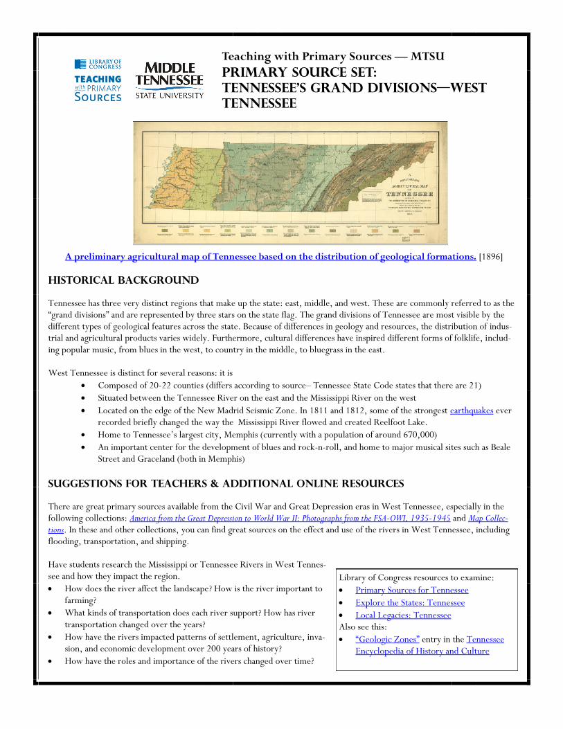
A preliminary agricultural map of Tennessee based on the distribution of geological formations. [1896]
Teaching with Primary Sources — MTSU
Primary Source Set:
Tennessee’s Grand Divisions—West
Tennessee

Shiloh National Military Park Tour Roads, Shiloh vicinity, Hardin County, TN
(Image #39: “BARGE TRAFFIC ON TENNESSEE
RIVER FROM LARGEST INDIAN MOUND”)
One of the few remaining old Mississippi River boats, Memphis, Tennessee. [1935]
West Tennessee College. Jackson, Tennessee. [1866]
Erosion control on Natchez Trace Project near Lexington, Tennessee. [1936]
Resettlement official investigating case of nine living in field on U.S. Route 70 between Camden and Bruceton, Tennessee, near Ten-nessee River. [1936]
Crawford-Governor Porter House, 407 Dunlap Street, Paris, Henry County, TN

Beale Street blues / by W.C. Handy. [1917]
The Bessie Levee augmented with sand bags during the 1937 flood. Near Tiptonville, Tennessee.
Balloon barrage training center. Lilluputians at a weemie roast. This illustration is portrayed here by comparing the huge balloons and dwarfed trainees seated in picnic fashion around their instructor. Camp Tyson, Tennes-see. Learn more about Camp Tyson here.
Medicine show, Huntingdon, Tennessee. [1935]
Battle of Shiloh or Pittsburg Landing, Tennessee. [1862-1865]
Edward Bates to Abraham Lincoln, Wednesday, May 04, 1864 (Opinion on Fort Pillow massacre). [Detail] Transcription available.

Citations: Tennessee’s Grand Divisions– WEST Tennessee
Teachers: Providing these primary source replicas without source clues may enhance the inquiry experience for students. This list of citations is supplied for refer-ence purposes to you and your students. We have followed the Chicago Manual of Style format, one of the formats recommended by the Library of Congress, for each entry below, minus the access date. The access date for each of these entries is December 14, 2009.
University of Tennessee, Knoxville. Agricultural Experiment Station. A preliminary agricultural map of Tennessee based on the distribution of geo-logical formations. Map. [S.1.], 1896. From the Library of Congress, Map Collections. http://memory.loc.gov/cgi-bin/query/r?ammem/gmd:@field(NUMBER+@band(g3961j+np000166)). Shahn, Ben, photographer. “One of the few remaining old Mississippi River boats, Memphis, Tennessee.” Photograph. October 1935. From the Library of Congress, America from the Great Depression to World War II: Photographs from the FSA-OWI, 1935-1945. http://memory.loc.gov/cgi-bin/query/r?ammem/fsaall:@field(NUMBER+@band(fsa+8a16435)). Mydans, Carl, photographer. “Erosion control on Natchez Trace Project near Lexington, Tennessee.” Photograph. March 1936. From the Library of Congress, America from the Great Depression to World War II: Photographs from the FSA-OWI, 1935-1945. http://memory.loc.gov/cgi-bin/query/r?ammem/fsaall:@field(NUMBER+@band(fsa+8a01563)). Mydans, Carl, photographer. “Resettlement official investigating case of nine living in field on U.S. Route 70 between Camden and Bruceton, Tennessee, near Tennessee River.” From the Library of Congress, America from the Great Depression to World War II: Photographs from the FSA-OWI, 1935-1945. http://memory.loc.gov/cgi-bin/query/r?ammem/fsaall:@field(NUMBER+@band(fsa+8a01635)). “Crawford-Governor Porter House, 407 Dunlap Street, Paris, Henry County, TN.” Drawing. n.d. From the Library of Congress, Built in America: Historic American Buildings Survey/ Historic American Engineering Record/ Historic American Landscapes Survey, 1933-Present. http://memory.loc.gov/cgi-bin/query/r?ammem/hh:@field(DOCID+@lit(TN0083)). West Tennessee College. Jackson, Tennessee. Advertisement.1866. From the Library of Congress, Emergence of Advertising in America: 1850-1920. http://memory.loc.gov/cgi-bin/query/r?ammem/eaa:@field(DOCID+@lit(eaa000110)). “Shiloh National Military Park Tour Roads, Shiloh vicinity, Hardin County, TN .” Photograph. n.d. From the Library of Congress, Built in America: Historic American Buildings Survey/ Historic American Engineering Record/ Historic American Landscapes Survey, 1933-Present. http://memory.loc.gov/cgi-bin/query/r?ammem/hh:@field(DOCID+@lit(TN0300)). Shahn, Ben, photographer. “Medicine show, Huntingdon, Tennessee.” Photograph. October 1935. From the Library of Congress, Amer-ica from the Great Depression to World War II: Photographs from the FSA-OWI, 1935-1945. http://memory.loc.gov/cgi-bin/query/r?ammem/fsaall:@filreq(@field(NUMBER+@band(fsa+8a16817))+@field(COLLID+fsa)). Evans, Walker, photographer. “The Bessie Levee augmented with sand bags during the 1937 flood. Near Tiptonville, Tennessee.” Pho-tograph. February 1937. From the Library of Congress, America from the Great Depression to World War II: Photographs from the FSA-OWI, 1935-1945. http://memory.loc.gov/cgi-bin/query/r?ammem/fsaall:@filreq(@field(NUMBER+@band(fsa+8a20393))+@field(COLLID+fsa)). “Balloon barrage training center. Lilluputians at a weemie roast. This illustration is portrayed here by comparing the huge balloons and dwarfed trainees seated in picnic fashion around their instructor. Camp Tyson, Tennessee.” Photograph. Between 1940 and 1946. From the Library of Congress, America from the Great Depression to World War II: Photographs from the FSA-OWI, 1935-1945. http://memory.loc.gov/cgi-bin/query/r?ammem/fsaall:@filreq(@field(NUMBER+@band(fsa+8b09861))+@field(COLLID+fsa)). Sneden, Robert Knox. Battle of Shiloh or Pittsburg Landing, Tennessee. Map. 1862-1865.From the Library of Congress, Map Collections. http://memory.loc.gov/cgi-bin/query/r?ammem/gmd:@field(NUMBER+@band(gvhs01+vhs00313)). Handy, W.C. “Beale Street blues / by W.C. Handy.” Sheet music. 1917. From the Library of Congress, African-American Sheet Music, 1850-1920. http://memory.loc.gov/cgi-bin/query/r?ammem/aasm:@field(NUMBER+@band(rpbaasm+0578)). Bates, Edward. Edward Bates to Abraham Lincoln, Wednesday, May 04, 1864 (Opinion on Fort Pillow massacre). From the Library of Congress, The Abraham Lincoln Papers at the Library of Congress. http://memory.loc.gov/cgi-bin/ampage?collId=mal&fileName=mal1/328/3280400/malpage.db&recNum=0.