te project application kaibab paiute local 2 - wacog · pipe springs rd -sr 389 to rv park rd, pipe...
TRANSCRIPT
ROUND 19
Page 1 of 14
Round 19 2012
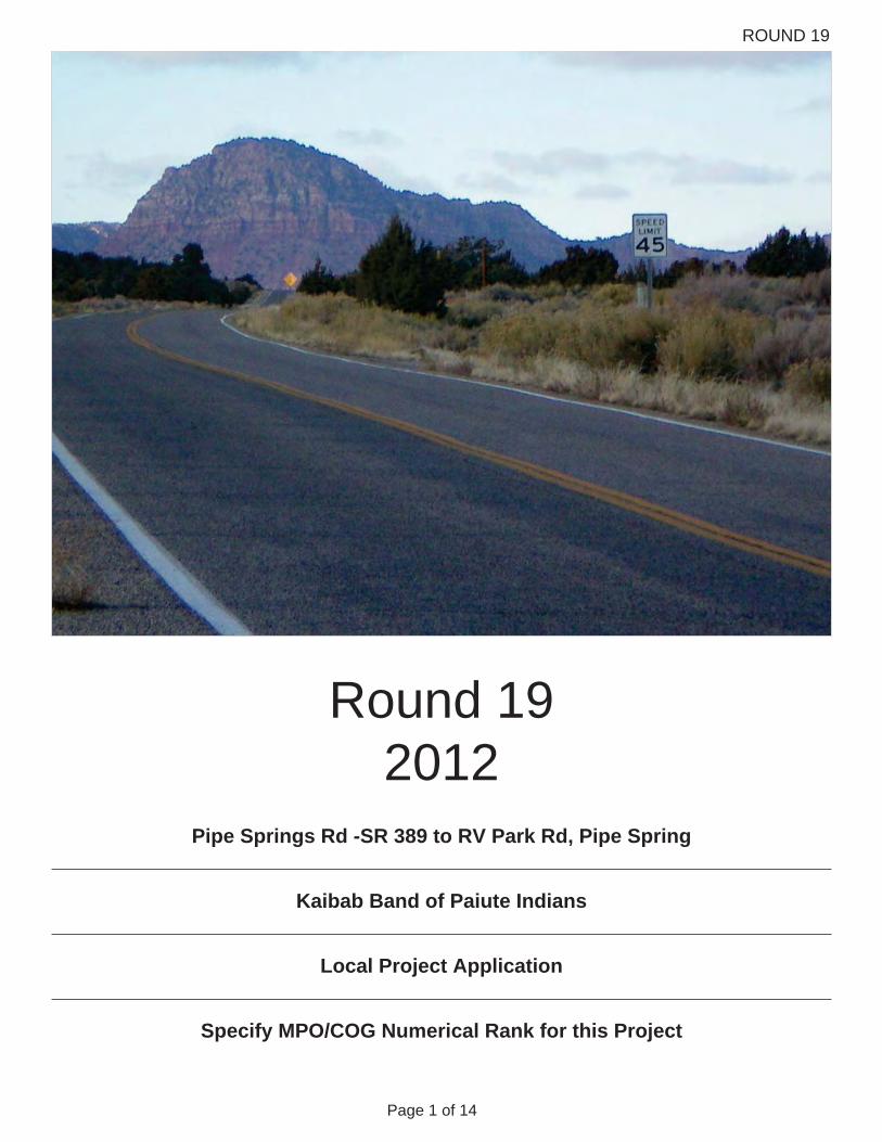
Pipe Springs Rd -SR 389 to RV Park Rd, Pipe Spring
Local Project Application
Kaibab Band of Paiute Indians
Specify MPO/COG Numerical Rank for this Project
ROUND 19
Page 2 of 14
1. Cover Page
2. Applicant Information (1-8)
APPLICATION SUBMITTAL REQUIREMENTS CHECKLIST
3. Project Description (10A - 13D)
4. Statement of Need
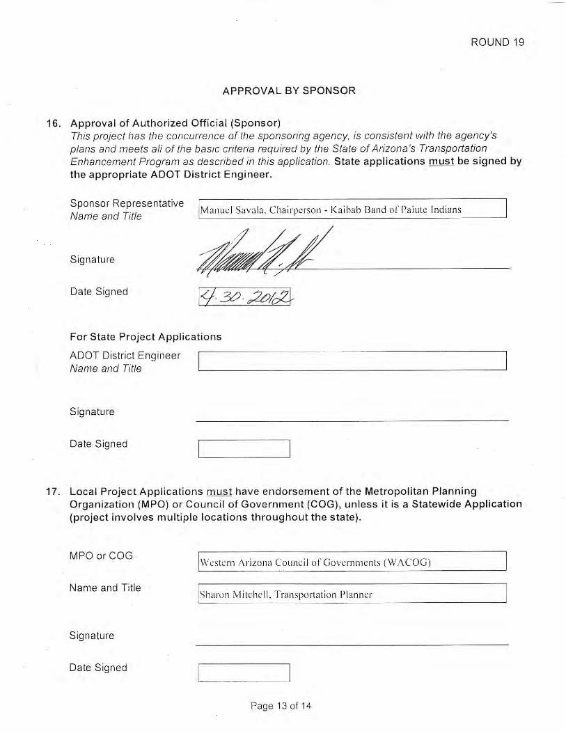
5. Authorized Official Signature
7. Cost Estimate Reviewer Signature
8. MPO/COG Signature
9. Cost Estimate Sheets (C1 - C4)
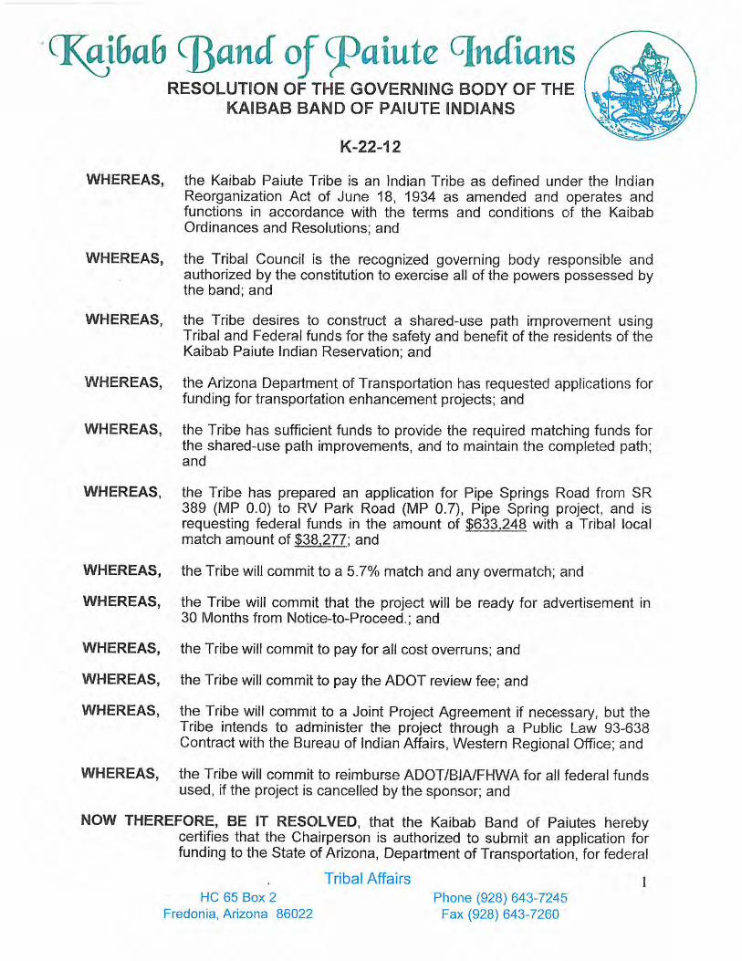
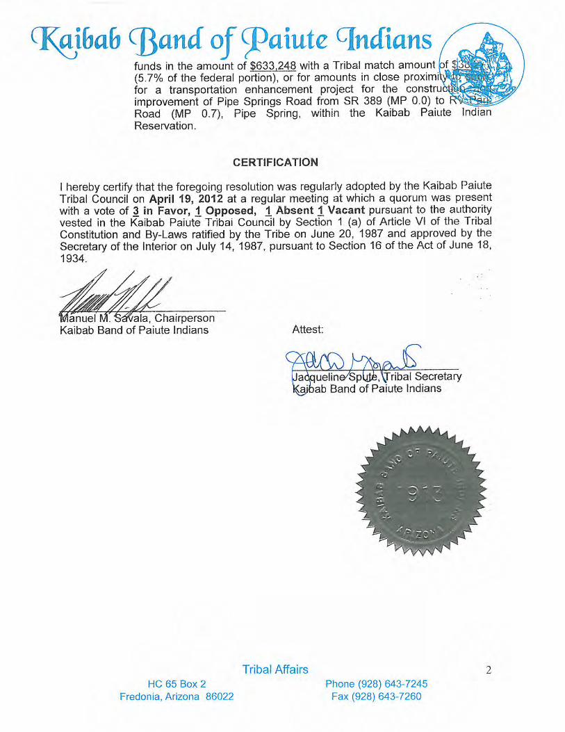
10. Appendix - Resolution
11. Appendix - State Map
12. Appendix - Vicinity Map
13. Appendix - Existing Location (Before) Photos
14. Appendix - Letters of Support - At Least One (1)
15. Appendix - Right-of-Way Ownership Documents

ROUND 19
Page 3 of 14
PROGRESS REPORT
Does the applicant have any active Transportation Enhancement (TE) projects?
OR Check off N/A below, if neither of the above applies. Word Count Maximum: 250 (1875 characters)
Yes NoIf yes, provide a status summary for each project in the text box below. Include milestones and scheduled construction date.
Yes No
Is the application for a new phase of any previously awarded TE projects?
If yes, provide a status summary for the phases in the text box below.
N/A
ROUND 19
Page 4 of 14
TRANSPORTATION ENHANCEMENT APPLICATION
Applicant and Sponsor
Western Arizona Council of Governments (WACOG)
1.
APPLICANT INFORMATION
Kaibab Band of Paiute Indians
MPO / COG 2.
Date3. Jun 11, 2012
4. Project Name and Limits Word Count Maximum: 50 (375 characters)
Pipe Springs Road from SR 389 to RV Park Road, Pipe Spring. Pipe Springs Road is County Road 240 beginning at SR 389 (MP 0.08) thence north to RV Park Road (MP 0.65).
5. Contact Person - Name and Title
Manuel Savala, Chairperson Kaibab Band of Paiute Indians
Mailing Address HC 65 Box 2
Fredonia
86022
City / Town
Zip Code
Phone Number
Fax Number928-643-7245
Email Address928-643-8329
ROUND 19
Page 5 of 14
APPLICANT INFORMATION Continued from previous page
County
Congressional District
Mohave
2nd District
6.
7.
8. Alternate Contact Person - Name and Title
Shirla Bundy, Finance Director Kaibab Band of Paiute Indians
Mailing Address HC Box 2 Fredonia, AZ 86022
Phone Number
Fax Number
Email Address [email protected]
928-643-7260
928-643-7245
ROUND 19
Page 6 of 14
PROVISION OF FACILITIES FOR PEDESTRIANS AND BICYCLES
PROVISION OF SAFETY AND EDUCATIONAL ACTIVITIES FOR PEDESTRIANS AND BICYCLISTS
PROJECT ACTIVITY CATEGORY
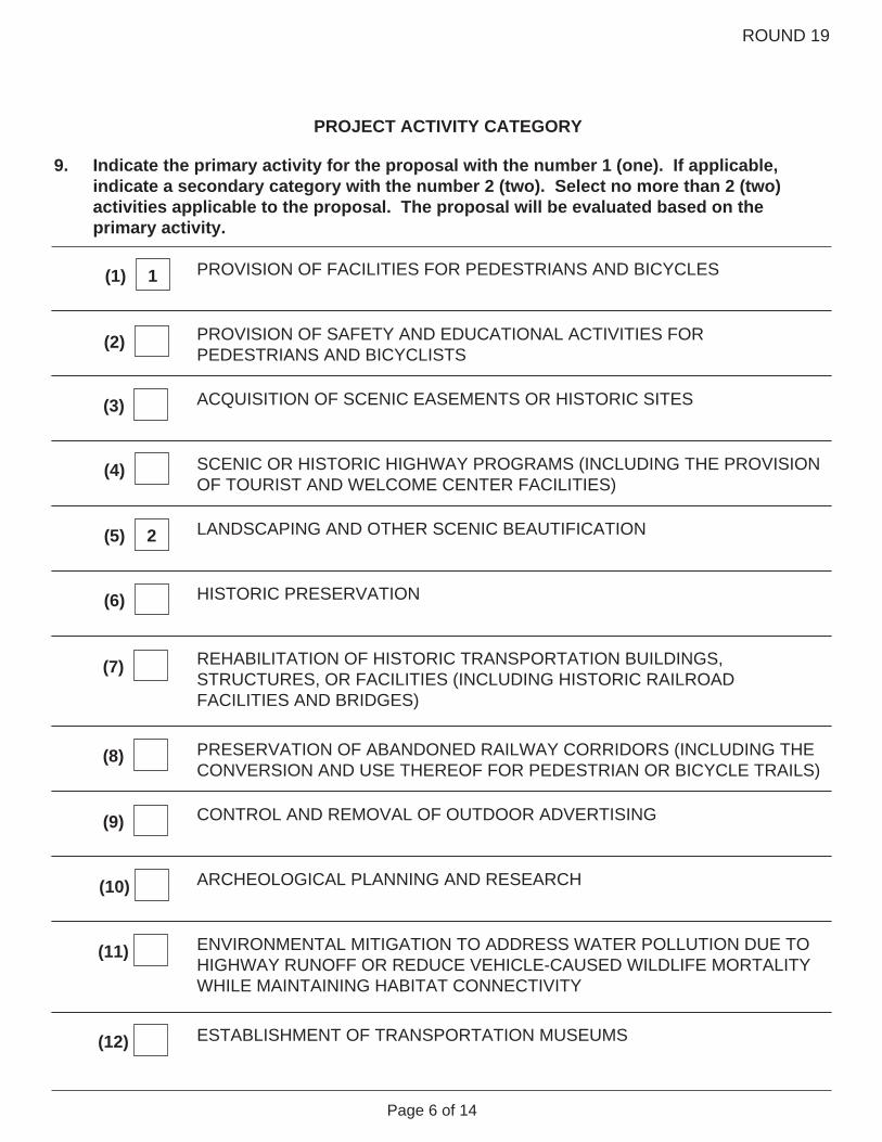
Indicate the primary activity for the proposal with the number 1 (one). If applicable, indicate a secondary category with the number 2 (two). Select no more than 2 (two) activities applicable to the proposal. The proposal will be evaluated based on the primary activity.
ACQUISITION OF SCENIC EASEMENTS OR HISTORIC SITES
SCENIC OR HISTORIC HIGHWAY PROGRAMS (INCLUDING THE PROVISION OF TOURIST AND WELCOME CENTER FACILITIES)
LANDSCAPING AND OTHER SCENIC BEAUTIFICATION
9.
HISTORIC PRESERVATION
REHABILITATION OF HISTORIC TRANSPORTATION BUILDINGS, STRUCTURES, OR FACILITIES (INCLUDING HISTORIC RAILROAD FACILITIES AND BRIDGES)
PRESERVATION OF ABANDONED RAILWAY CORRIDORS (INCLUDING THE CONVERSION AND USE THEREOF FOR PEDESTRIAN OR BICYCLE TRAILS)
CONTROL AND REMOVAL OF OUTDOOR ADVERTISING
ENVIRONMENTAL MITIGATION TO ADDRESS WATER POLLUTION DUE TO HIGHWAY RUNOFF OR REDUCE VEHICLE-CAUSED WILDLIFE MORTALITY WHILE MAINTAINING HABITAT CONNECTIVITY
ESTABLISHMENT OF TRANSPORTATION MUSEUMS
ARCHEOLOGICAL PLANNING AND RESEARCH
(1) 1
(2)
(3)
(4)
(5) 2
(6)
(7)
(8)
(9)
(10)
(11)
(12)
ROUND 19
Page 7 of 14
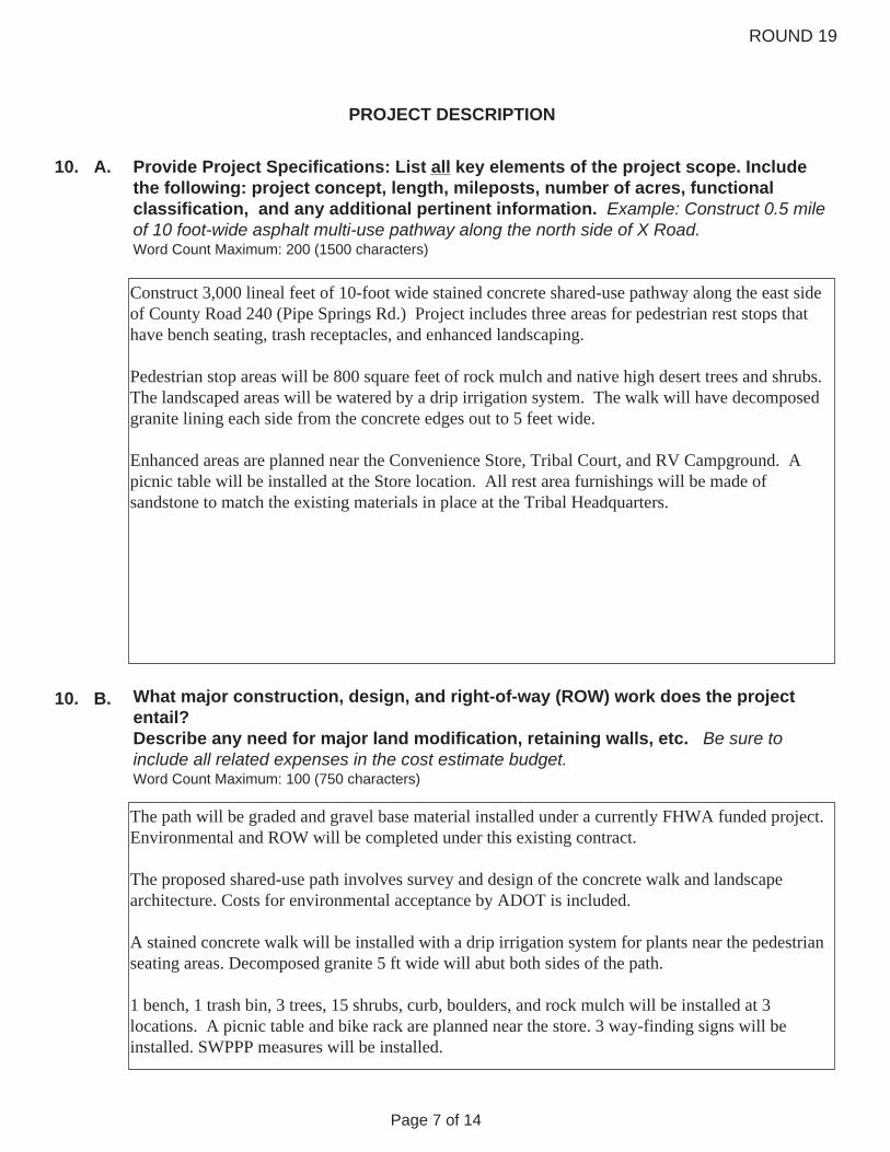
10. Provide Project Specifications: List all key elements of the project scope. Include the following: project concept, length, mileposts, number of acres, functional classification, and any additional pertinent information. Example: Construct 0.5 mile of 10 foot-wide asphalt multi-use pathway along the north side of X Road. Word Count Maximum: 200 (1500 characters)
PROJECT DESCRIPTION
A.
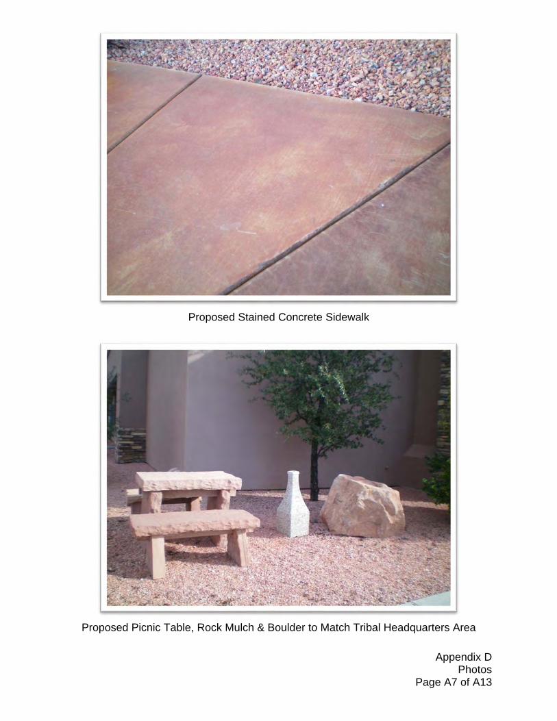
Construct 3,000 lineal feet of 10-foot wide stained concrete shared-use pathway along the east side of County Road 240 (Pipe Springs Rd.) Project includes three areas for pedestrian rest stops that have bench seating, trash receptacles, and enhanced landscaping. Pedestrian stop areas will be 800 square feet of rock mulch and native high desert trees and shrubs. The landscaped areas will be watered by a drip irrigation system. The walk will have decomposed granite lining each side from the concrete edges out to 5 feet wide. Enhanced areas are planned near the Convenience Store, Tribal Court, and RV Campground. A picnic table will be installed at the Store location. All rest area furnishings will be made of sandstone to match the existing materials in place at the Tribal Headquarters.
What major construction, design, and right-of-way (ROW) work does the project entail? Describe any need for major land modification, retaining walls, etc. Be sure to include all related expenses in the cost estimate budget. Word Count Maximum: 100 (750 characters)
B. 10.
The path will be graded and gravel base material installed under a currently FHWA funded project. Environmental and ROW will be completed under this existing contract. The proposed shared-use path involves survey and design of the concrete walk and landscape architecture. Costs for environmental acceptance by ADOT is included. A stained concrete walk will be installed with a drip irrigation system for plants near the pedestrian seating areas. Decomposed granite 5 ft wide will abut both sides of the path. 1 bench, 1 trash bin, 3 trees, 15 shrubs, curb, boulders, and rock mulch will be installed at 3 locations. A picnic table and bike rack are planned near the store. 3 way-finding signs will be installed. SWPPP measures will be installed.

ROUND 19
Page 8 of 14
Where is the project located?11. A. • Describe actual physical location • Attach state and vicinity map in appendix • For State projects, include the route and beginning and ending mileposts Word Count Maximum: 100 (750 characters)
PROJECT DESCRIPTION Continued from previous page
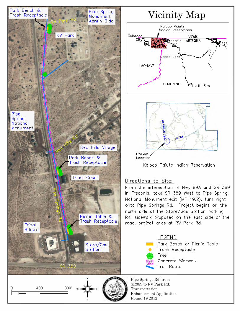
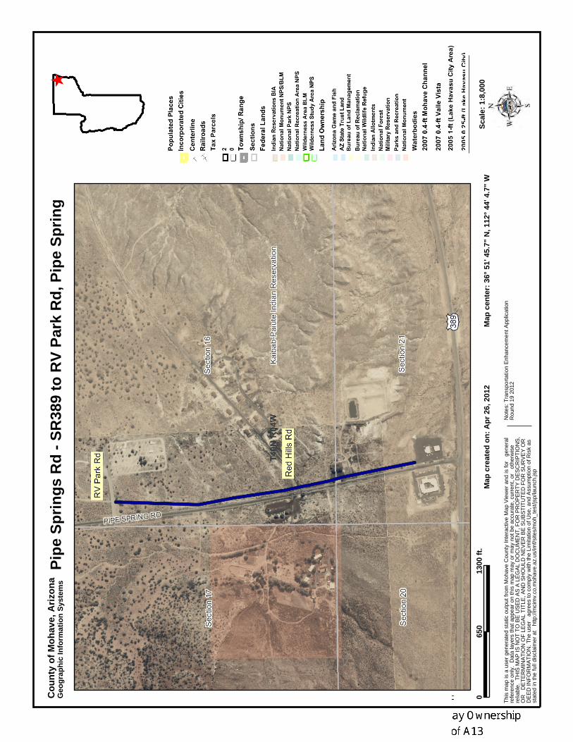
The project is within the Kaibab Paiute Indian Reservation along County Route 240 (Pipe Springs Road) in Pipe Spring, Mohave County, Arizona. The pathway begins at the Convenience Store and ends at the RV Campground drive entrance. The sidewalk will be located in an exclusively dedicated right-of-way abutting the existing county road right-of-way at approximately sixty feet (60') east of the road center line. See Appendix B for State Map and Appendix C for Vicinity Map.
Who owns the ROW of the proposed project? Provide proof or ROW ownership in Appendix. (Not Applicable for Activities 2 and 10 only)
Kaibab Band of Paiute Indians. See Appendix F for Assessor's Map.
B. 11.
Yes
%
Are any private landowners involved? If the project is on ADOT ROW, what percent of the project area is on ADOT ROW? (Percentage is determined by the ADOT District Engineer)
If this is a rail corridor project, is the corridor “rail banked”? If yes, provide status: Word Count Maximum: 50 (375 characters)
Yes No
No
N/A
N/A (not a rail corridor project)(not a rail corridor project)(not a rail corridor project)
YesIs the abandonment authorized by or proceeding before the Interstate Rail Commission? If yes, provide status: Word Count Maximum: 50 (375 characters)
No
N/A (not a rail corridor project)
ROUND 19
Page 9 of 14
PROJECT DESCRIPTION Continued from previous page
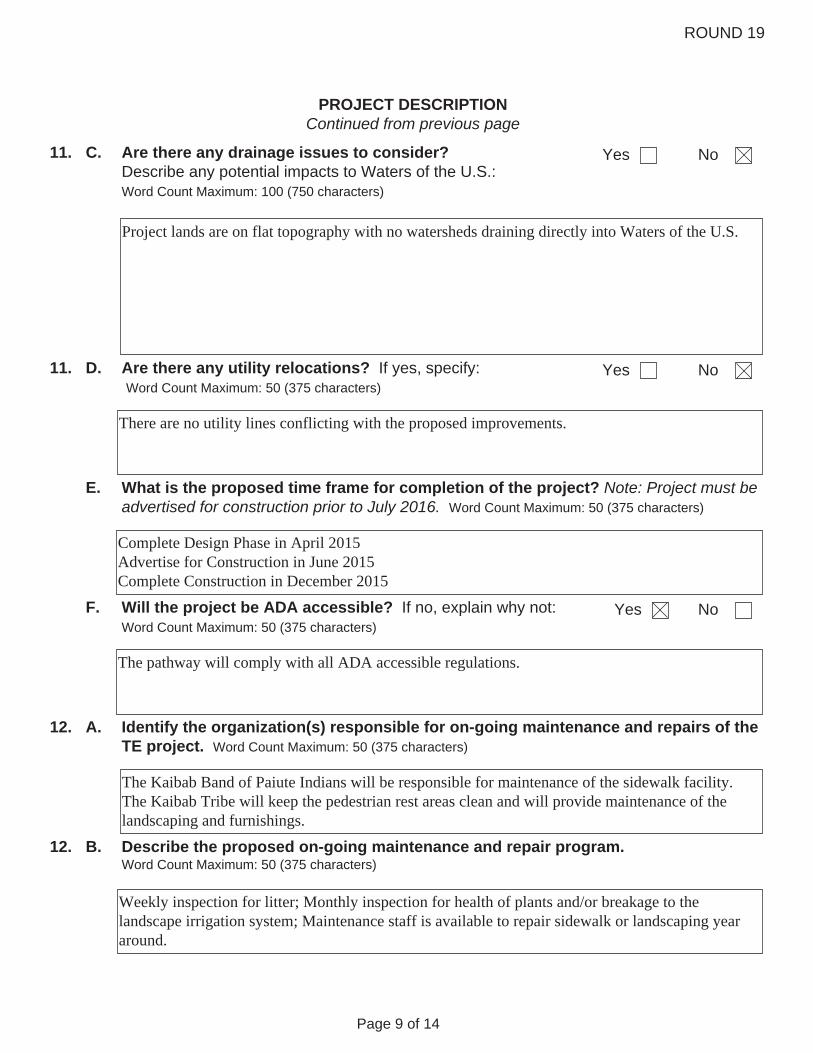
C. Are there any drainage issues to consider? Describe any potential impacts to Waters of the U.S.: Word Count Maximum: 100 (750 characters)
Yes No11.
Project lands are on flat topography with no watersheds draining directly into Waters of the U.S.
11. D. Are there any utility relocations? If yes, specify: Word Count Maximum: 50 (375 characters)
NoYes
There are no utility lines conflicting with the proposed improvements.
E. What is the proposed time frame for completion of the project? Note: Project must be advertised for construction prior to July 2016. Word Count Maximum: 50 (375 characters)
Complete Design Phase in April 2015 Advertise for Construction in June 2015 Complete Construction in December 2015
F. Will the project be ADA accessible? If no, explain why not: Word Count Maximum: 50 (375 characters)
NoYes
The pathway will comply with all ADA accessible regulations.
A. Identify the organization(s) responsible for on-going maintenance and repairs of the TE project. Word Count Maximum: 50 (375 characters)
12.
The Kaibab Band of Paiute Indians will be responsible for maintenance of the sidewalk facility. The Kaibab Tribe will keep the pedestrian rest areas clean and will provide maintenance of the landscaping and furnishings.
B. Describe the proposed on-going maintenance and repair program. Word Count Maximum: 50 (375 characters)
12.
Weekly inspection for litter; Monthly inspection for health of plants and/or breakage to the landscape irrigation system; Maintenance staff is available to repair sidewalk or landscaping year around.
ROUND 19
Page 10 of 14
C.
PROJECT DESCRIPTION Continued from previous page
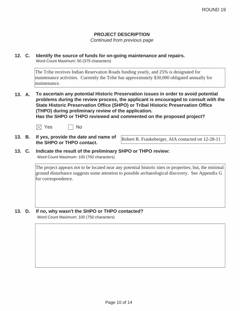
Identify the source of funds for on-going maintenance and repairs. Word Count Maximum: 50 (375 characters)
12.
The Tribe receives Indian Reservation Roads funding yearly, and 25% is designated for maintenance activities. Currently the Tribe has approximately $30,000 obligated annually for maintenance.
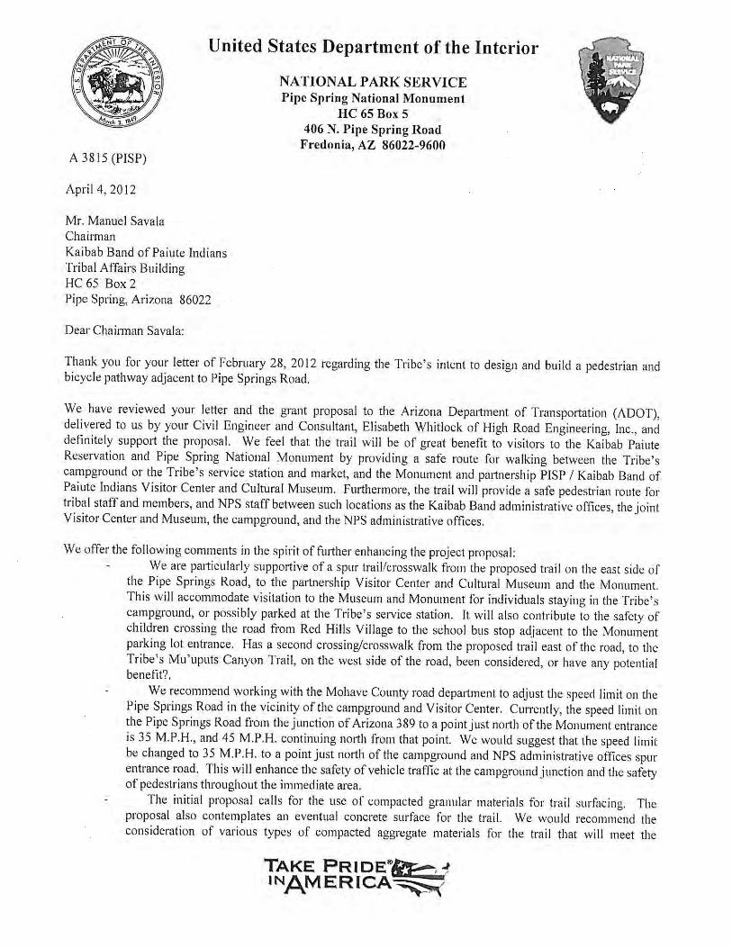
13. To ascertain any potential Historic Preservation issues in order to avoid potential problems during the review process, the applicant is encouraged to consult with the State Historic Preservation Office (SHPO) or Tribal Historic Preservation Office (THPO) during preliminary review of the application. Has the SHPO or THPO reviewed and commented on the proposed project?
Yes No
13. If yes, provide the date and name of the SHPO or THPO contact.
Indicate the result of the preliminary SHPO or THPO review: Word Count Maximum: 100 (750 characters)
A.
B. Robert R. Frankeberger, AIA contacted on 12-28-11
13. C.
The project appears not to be located near any potential historic sites or properties; but, the minimal ground disturbance suggests some attention to possible archaeological discovery. See Appendix G for correspondence.
If no, why wasn't the SHPO or THPO contacted? Word Count Maximum: 100 (750 characters)
13. D.

ROUND 19
Page 11 of 14
14. A. Is the project on a:
Planned transportation corridor? Yes No
Corridor under construction? Yes No
Existing transportation corridor? Yes No
If yes, estimated completion date?
If yes, scheduled completion date?
STATEMENT OF NEED
Describe how the community was or will be involved in this project. Word Count Maximum: 200 (1500 characters)
B. 14.
The community was involved in prioritizing this project. Public meetings were held for community input during the Long Range Transportation Plan process, during Phase 1 to determine alignment and connectivity patterns, and as a part of this application. Maps to describe the project were displayed at all Villages and Community Buildings throughout the Reservation with requests for comments. Information was distributed in the Tribal Newsletter with requests for comments. Public meetings were held to comply with the National Environmental Policy Act to inform the community on the scope and impacts of the proposed pathway. Similar outreach will continue for the enhancement phase of the project. The project planning process was open to the community during the following times: Annual Meeting on October 2, 2010 and October 1, 2011 Report at each Tribal Council meeting in October-December 2011 and January-March 2012 Public meeting for path Environmental Assessment on March 20, 2012 Tribal Council meeting to hear resolution supporting application April 19, 2012

ROUND 19
Page 12 of 14
STATEMENT OF NEED Continued from previous page
15. Describe how the project is an enhancement. Word Count Maximum: 250 (1875 characters)
The current pathway is gravel. There are no all-weather surfaces for pedestrian or bicycle use along this corridor. Having a hard surface on this pathway between the Convenience Store and the RV Park will encourage people to walk off of the roadway away from vehicle traffic. The improvements will enhance both the visitor experience to Pipe Spring National Monument as well as provide benefit to Tribal residents. Visitors to the Monument will see native trees and landscaped areas on their way to the site which will be inviting and impress upon them a welcoming environment. Residents will have a safe path to travel which is shaded in the summer months and provides break areas if they are walking long distances. The picnic table at the Store will enhance the project with an additional break area for travelers, visitors, and employees at the Store and the Tribal Headquarters.


ITEM DESCRIPTION UNIT QUAN.UNIT
PRICE TOTALFEDERAL TE
FUNDS @ 94.3%LOCALFUNDS
1. SITE TOPOGRAPHIC SURVEY LS 1 $12,500.00 $12,500.00 $11,787.50 $712.50
2. PROJECT ASSESSMENT REPORT or DETAILED WORKPLAN LS 1 $5,000.00 $5,000.00 $4,715.00 $285.00
3. ENVIRONMENTAL DETERMINATION (Infrastructure projects, including technical supporting documents)
LS 1 $20,000.00 $20,000.00 $18,860.00 $1,140.00
4. HAZMAT ASSESSMENT LS 1 $0.00 $0.00 $0.00
$ 37,500 $35,363 $2,138
1. Right-of-Way Acquisition LS 1 $0.00 $0.00 $0.00
2. Plans, Special Provisions or Bid Manual, Cost Estimate & Schedules. LS 1 $42,000.00 $42,000.00 $39,606.00 $2,394.00
3. GEOTECHNICAL INVESTIGATION and Materials & Pavement Design Report LS 1 $6,500.00 $6,500.00 $6,129.50 $370.50
4. DRAINAGE REPORT LS 1 $0.00 $0.00 $0.00
5. SWPPP LS 1 $3,000.00 $3,000.00 $2,829.00 $171.00
$51,500.00 $48,565 $2,936
INSTALLATION OF SWPP MEASURES LS 1 $9,500.00 $9,500.00 $8,958.50 $541.50
SITE PREPARATION LS 1 $25,000.00 $25,000.00 $23,575.00 $1,425.00
DEMOLITION
Sawcut LF $0.00 $0.00 $0.00
Remove Structures and Obstructions LS 1 $0.00 $0.00 $0.00
1. HARDSCAPE CONSTRUCTION
C. CONSTRUCTION OR IMPLEMENTATIONFor non-infrastructure projects (no ground disturbing activities), address only parts 4, D and F.
ARIZONA TRANSPORTATION ENHANCEMENT PROGRAM
ROUND 19 (2012) COST ESTIMATE
B. FINAL PRELIMINARY ENGINEERING DESIGN - Stages II, III, IV and PS&E(Not applicable to non-infrastructure projects)
A. SCOPING (15% Preliminary Engineering Design)(Non-infrastructure projects: Only #2 applies).
SUBTOTAL – PROJECT SCOPING COSTS
SUBTOTAL – PROJECT DESIGN COSTS
ARIZONA TRANSPORTATION ENHANCEMENT PROGRAMRound 19 (2012) Project Cost Estimate
Page C1 of C4

ITEM DESCRIPTION UNIT QUAN.UNIT
PRICE TOTALFEDERAL TE
FUNDS @ 94.3%LOCALFUNDS
Remove Fencing LF $0.00 $0.00 $0.00
Remove Structural Concrete $0.00 $0.00 $0.00
Remove Asphaltic Concrete Pavement $0.00 $0.00 $0.00
Remove Concrete Sidewalks, Slabs $0.00 $0.00 $0.00
HAZMAT ABATEMENT LS 1 $0.00 $0.00 $0.00
UTILITY RELOCATION LS 1 $0.00 $0.00 $0.00
RETAINING WALLReinforced concrete cantilevered SF $0.00 $0.00 $0.00
EARTHWORK
General Excavation $0.00 $0.00 $0.00
Drainage Excavation $0.00 $0.00 $0.00
Structural Excavation $0.00 $0.00 $0.00
Structural Backfill $0.00 $0.00 $0.00
Borrow (In Place) $0.00 $0.00 $0.00
CURB & GUTTER LF $0.00 $0.00 $0.00
AGGREGATE BASE CY $0.00 $0.00 $0.00
PATHWAY OR SIDEWALK MATERIALS
Concrete $0.00 $0.00 $0.00
Colored Concrete 31,000 $9.00 $279,000.00 $263,097.00 $15,903.00
Stamped Color Concrete $0.00 $0.00 $0.00
Precast Concrete Pavers $0.00 $0.00 $0.00
Asphaltic Concrete Ton $0.00 $0.00 $0.00
Polymer or Resin Stabilized Surface SF $0.00 $0.00 $0.00
CROSSWALK ENHANCEMENT
Concrete Pavers $0.00 $0.00 $0.00
Stamped Asphalt $0.00 $0.00 $0.00
Stamped Concrete $0.00 $0.00 $0.00
Concrete $0.00 $0.00 $0.00
Integral Color Concrete $0.00 $0.00 $0.00
PEDESTRIAN ADA RAMP SF $0.00 $0.00 $0.00
CULVERT EXTENSIONS LF $0.00 $0.00 $0.00
PEDESTRIAN LIGHTINGIncluding conduit and trenching Each $0.00 $0.00 $0.00
HANDRAIL
Standard $0.00 $0.00 $0.00
Decorative $0.00 $0.00 $0.00
$313,500.00 $295,631 $17,870
CY
LF
CY
SF
SF
SUBTOTAL - HARDSCAPE CONSTRUCTION
ARIZONA TRANSPORTATION ENHANCEMENT PROGRAMRound 19 (2012) Project Cost Estimate
Page C2 of C4

ITEM DESCRIPTION UNIT QUAN.UNIT
PRICE TOTALFEDERAL TE
FUNDS @ 94.3%LOCALFUNDS
TREES above 15 gallon in size as required per Local code or special design requirements
Each $0.00 $0.00 $0.00
TREES (15 GALLON SIZE) Each $0.00 $0.00 $0.00
TREES (5 GALLON SIZE) Each 10 $175.00 $1,750.00 $1,650.25 $99.75
SHRUBS (5 GALLON SIZE) Each 15 $45.00 $675.00 $636.53 $38.48
SHRUBS (1 GALLON SIZE) Each 30 $35.00 $1,050.00 $990.15 $59.85
CACTUS (5 GALLON SIZE) Each $0.00 $0.00 $0.00
MULCH
Decomposed Granite 300 $191.00 $57,300.00 $54,033.90 $3,266.10
Organic $0.00 $0.00 $0.00
TOPSOIL CY 50 $150.00 $7,500.00 $7,072.50 $427.50
SEEDING Acre $0.00 $0.00 $0.00
TURF SOD SY $0.00 $0.00 $0.00
BOULDERS Each 20 $250.00 $5,000.00 $4,715.00 $285.00
IRRIGATION SYSTEM
Drip 5,500 $4.50 $24,750.00 $23,339.25 $1,410.75
Turf $0.00 $0.00 $0.00
SLEEVING FOR IRRIGATION SYSTEM
Directional Bore $0.00 $0.00 $0.00
Cut and Patch 20 $150.00 $3,000.00 $2,829.00 $171.00
LANDSCAPE HEADER CURB LF 400 $20.00 $8,000.00 $7,544.00 $456.00
LANDSCAPE ESTABLISHMENT LS 1 $10,000.00 $10,000.00 $9,430.00 $570.00
$119,025.00 $112,241 $6,784
BENCHES Each 3 $750.00 $2,250.00 $2,121.75 $128.25
SEATWALLS LF $0.00 $0.00 $0.00
BIKE RACKS Each 1 $600.00 $600.00 $565.80 $34.20
TRASH RECEPTACLES Each 3 $850.00 $2,550.00 $2,404.65 $145.35
DRINKING FOUNTAINS Each $0.00 $0.00 $0.00
SIGNAGE (Standard Traffic Control) Each 3 $250.00 $750.00 $707.25 $42.75
TREE GRATES Each $0.00 $0.00 $0.00
$6,150.00 $5,799 $351
PICNIC TABLE Each 1 $2,750.00 $2,750.00 $2,593.25 $156.75 WEED BARRIER FABRIC SF 32,400 $0.25 $8,100.00 $7,638.30 $461.70
$0.00 $0.00 $0.00
$0.00 $0.00 $0.00
$0.00 $0.00 $0.00
$0.00 $0.00 $0.00
LF
3. SITE FURNISHINGS
4. OTHER CONSTRUCTION ITEMS. ALSO, ITEMIZED LINE ITEMS FOR NON-INFRASTRUCTURE PROJECTS.(Insert additional rows if necessary)
SUBTOTAL – LANDSCAPING & IRRIGATION ITEMS
SF
SUBTOTAL – SITE FURNISHINGS
CY
2. LANDSCAPING & IRRIGATION ITEMS
ARIZONA TRANSPORTATION ENHANCEMENT PROGRAMRound 19 (2012) Project Cost Estimate
Page C3 of C4
ITEM DESCRIPTION UNIT QUAN.UNIT
PRICE TOTALFEDERAL TE
FUNDS @ 94.3%LOCALFUNDS
$0.00 $0.00 $0.00
$0.00 $0.00 $0.00
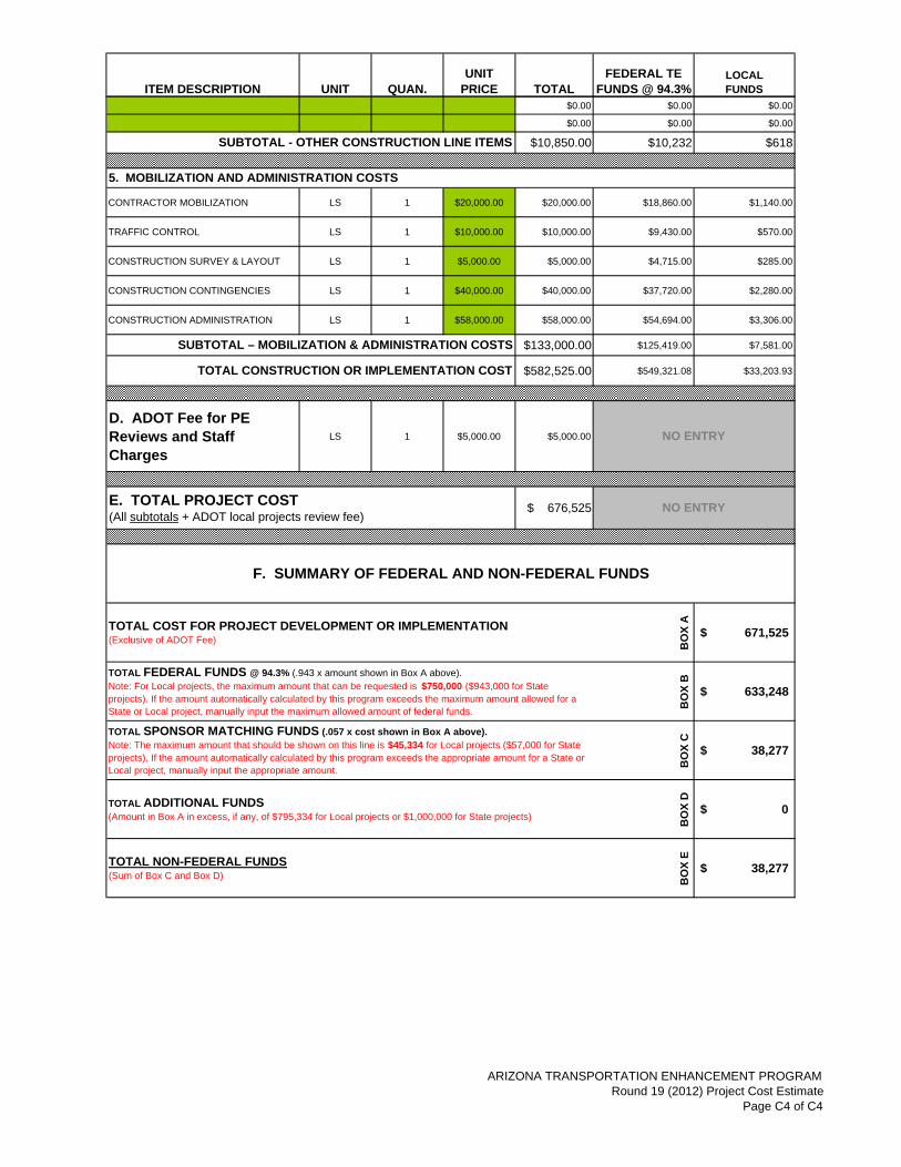
$10,850.00 $10,232 $618
CONTRACTOR MOBILIZATION LS 1 $20,000.00 $20,000.00 $18,860.00 $1,140.00
TRAFFIC CONTROL LS 1 $10,000.00 $10,000.00 $9,430.00 $570.00
CONSTRUCTION SURVEY & LAYOUT LS 1 $5,000.00 $5,000.00 $4,715.00 $285.00
CONSTRUCTION CONTINGENCIES LS 1 $40,000.00 $40,000.00 $37,720.00 $2,280.00
CONSTRUCTION ADMINISTRATION LS 1 $58,000.00 $58,000.00 $54,694.00 $3,306.00
$133,000.00 $125,419.00 $7,581.00
$582,525.00 $549,321.08 $33,203.93
D. ADOT Fee for PE Reviews and Staff Charges
LS 1 $5,000.00 $5,000.00
$ 676,525
BO
X A
671,525$
BO
X B
633,248$ B
OX
C
38,277$
BO
X D
0$
BO
X E
38,277$
TOTAL CONSTRUCTION OR IMPLEMENTATION COST
SUBTOTAL - OTHER CONSTRUCTION LINE ITEMS
NO ENTRYE. TOTAL PROJECT COST(All subtotals + ADOT local projects review fee)
NO ENTRY
F. SUMMARY OF FEDERAL AND NON-FEDERAL FUNDS
TOTAL FEDERAL FUNDS @ 94.3% (.943 x amount shown in Box A above).Note: For Local projects, the maximum amount that can be requested is $750,000 ($943,000 for State projects). If the amount automatically calculated by this program exceeds the maximum amount allowed for a State or Local project, manually input the maximum allowed amount of federal funds.
TOTAL NON-FEDERAL FUNDS(Sum of Box C and Box D)
5. MOBILIZATION AND ADMINISTRATION COSTS
SUBTOTAL – MOBILIZATION & ADMINISTRATION COSTS
TOTAL SPONSOR MATCHING FUNDS (.057 x cost shown in Box A above).Note: The maximum amount that should be shown on this line is $45,334 for Local projects ($57,000 for State projects). If the amount automatically calculated by this program exceeds the appropriate amount for a State or Local project, manually input the appropriate amount.
TOTAL ADDITIONAL FUNDS(Amount in Box A in excess, if any, of $795,334 for Local projects or $1,000,000 for State projects)
TOTAL COST FOR PROJECT DEVELOPMENT OR IMPLEMENTATION(Exclusive of ADOT Fee)
ARIZONA TRANSPORTATION ENHANCEMENT PROGRAMRound 19 (2012) Project Cost Estimate
Page C4 of C4

State Map
Pipe Springs Road from SR 389 to RV Park Road
Transportation Enhancement Application
Round 19 2012
Appendix B
ProjectLocation
N
S
W E
Pipe Springs Rd. fromSR389 to RV Park Rd.TransportationEnhancement ApplicationRound 19 2012
0 400' 800'
Vicinity Map
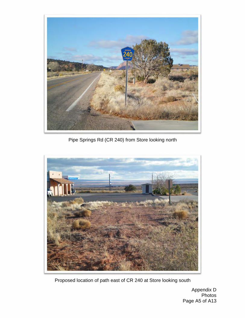
Appendix D Photos Page A5 of A13
Pipe Springs Rd (CR 240) from Store looking north
Proposed location of path east of CR 240 at Store looking south

Appendix D Photos Page A6 of A13
Pipe Springs Rd (CR 240) at Red Hills Rd (Red Hills Village) looking north
Proposed location of path at RV Park Rd looking south
Appendix D Photos Page A7 of A13
Proposed Stained Concrete Sidewalk
Proposed Picnic Table, Rock Mulch & Boulder to Match Tribal Headquarters Area

Co
un
ty o
f M
oh
ave,
Ari
zon
aG
eog
rap
hic
Info
rmat
ion
Sys
tem
sP
ipe
Sp
rin
gs
Rd
- S
R38
9 to
RV
Par
k R
d, P
ipe
Sp
rin
g
065
013
00ft
.M
ap c
reat
ed o
n:
Ap
r 26
, 201
2M
ap c
ente
r: 3
6° 5
1' 4
5.7"
N, 1
12°
44' 4
.7"
W
Thi
s m
ap is
a u
ser
gene
rate
d st
atic
out
put f
rom
Moh
ave
Cou
nty
Inte
ract
ive
Map
Vie
wer
and
is fo
r g
ener
alre
fere
nce
only
. D
ata
laye
rs th
at a
ppea
r on
this
map
may
or
may
not
be
accu
rate
, cur
rent
, or
oth
erw
ise
relia
ble.
TH
IS M
AP
IS N
OT
TO
BE
US
ED
AS
A L
EG
AL
DO
CU
ME
NT
, FO
R P
RO
PE
RT
Y D
ES
CR
IPT
ION
S,
OR
D
ET
ER
MIN
AT
ION
OF
LE
GA
L T
ITLE
, AN
D S
HO
ULD
NE
VE
R B
E S
UB
ST
ITU
TE
D F
OR
SU
RV
EY
OR
DE
ED
INF
OR
MA
TIO
N. T
he u
ser
agr
ees
to c
ompl
y w
ith th
e Li
mita
tion
of U
se, a
nd A
ssum
ptio
n of
Ris
k as
stat
ed in
the
full
disc
laim
er a
t h
ttp://
mci
mv.
co.m
ohav
e.az
.us/
imf/s
ites/
moh
_tes
t/jsp
/laun
ch.js
p
Not
es: T
rans
port
atio
n E
nhan
cem
ent A
pplic
atio
nR
ound
19
2012
Sca
le:
1:8,
000
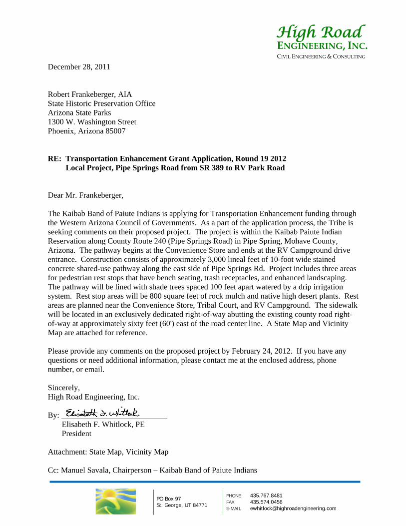
December 28, 2011 Robert Frankeberger, AIA State Historic Preservation Office Arizona State Parks 1300 W. Washington Street Phoenix, Arizona 85007 RE: Transportation Enhancement Grant Application, Round 19 2012 Local Project, Pipe Springs Road from SR 389 to RV Park Road Dear Mr. Frankeberger, The Kaibab Band of Paiute Indians is applying for Transportation Enhancement funding through the Western Arizona Council of Governments. As a part of the application process, the Tribe is seeking comments on their proposed project. The project is within the Kaibab Paiute Indian Reservation along County Route 240 (Pipe Springs Road) in Pipe Spring, Mohave County, Arizona. The pathway begins at the Convenience Store and ends at the RV Campground drive entrance. Construction consists of approximately 3,000 lineal feet of 10-foot wide stained concrete shared-use pathway along the east side of Pipe Springs Rd. Project includes three areas for pedestrian rest stops that have bench seating, trash receptacles, and enhanced landscaping. The pathway will be lined with shade trees spaced 100 feet apart watered by a drip irrigation system. Rest stop areas will be 800 square feet of rock mulch and native high desert plants. Rest areas are planned near the Convenience Store, Tribal Court, and RV Campground. The sidewalk will be located in an exclusively dedicated right-of-way abutting the existing county road right-of-way at approximately sixty feet (60') east of the road center line. A State Map and Vicinity Map are attached for reference. Please provide any comments on the proposed project by February 24, 2012. If you have any questions or need additional information, please contact me at the enclosed address, phone number, or email. Sincerely, High Road Engineering, Inc. By: Elisabeth F. Whitlock, PE President Attachment: State Map, Vicinity Map Cc: Manuel Savala, Chairperson – Kaibab Band of Paiute Indians
PO Box 97 St. George, UT 84771
PHONE 435.767.8481 FAX 435.574.0456 E-MAIL [email protected]
High Road ENGINEERING, INC.CIVIL ENGINEERING & CONSULTING
1
Elisabeth Whitlock
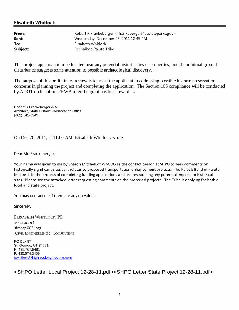
From: Robert R Frankeberger <[email protected]>Sent: Wednesday, December 28, 2011 12:45 PMTo: Elisabeth WhitlockSubject: Re: Kaibab Paiute Tribe
This project appears not to be located near any potential historic sites or properties; but, the minimal ground disturbance suggests some attention to possible archaeological discovery. The purpose of this preliminary review is to assist the applicant in addressing possible historic preservation concerns in planning the project and completing the application. The Section 106 compliance will be conducted by ADOT on behalf of FHWA after the grant has been awarded. Robert R Frankeberger AIA Architect, State Historic Preservation Office (602) 542-6943 On Dec 28, 2011, at 11:00 AM, Elisabeth Whitlock wrote: Dear Mr. Frankeberger, Your name was given to me by Sharon Mitchell of WACOG as the contact person at SHPO to seek comments on historically significant sites as it relates to proposed transportation enhancement projects. The Kaibab Band of Paiute Indians is in the process of completing funding applications and are researching any potential impacts to historical sites. Please see the attached letter requesting comments on the proposed projects. The Tribe is applying for both a local and state project. You may contact me if there are any questions. Sincerely,
ELISABETH WHITLOCK, PE President <image003.jpg> CIVIL ENGINEERING & CONSULTING PO Box 97 St. George, UT 84771 P: 435.767.8481 F: 435.574.0456 [email protected]
<SHPO Letter Local Project 12-28-11.pdf><SHPO Letter State Project 12-28-11.pdf>