te kowhai airfield rezoning plan
TRANSCRIPT

Te Kowhai Airfield
Rezoning Plan
Integrated Transport Assessment
September 2017

Te Kowhai Airfield Rezoning Plan
Integrated Transport Assessment
September 2017 Report Prepared by: Tara Hills Date Checked by: Kathy Tao Date Approved for issue by: Cameron Inder Date
Bloxam Burnett & Olliver Ltd
Level 5, 18 London Street Hamilton
Ph: 07 838 0144 Fax: 07 839 0431
Email: [email protected]

DOCUMENT HISTORY AND STATUS
Issue Rev. Issued To Qty Date Prepared Reviewed Approved
1 Draft The NZ Transport Agency 1E 12/9/17 T Hills K Tao C Inder
Printed: 12 September, 2017
Last Saved: 12 September, 2017
Project Manager: Andrew McFarlane
Name of Organisation: Bloxam Burnett & Olliver Ltd
Name of Project: Te Kowhai Airfield
Name of Report: Integrated Transport Assessment; September 2017
Report Version: DRAFT
Project Number: 144310.06

Bloxam Burnett & Olliver Ltd Te Kowhai Airpark Page 1
TABLE OF CONTENTS 1.0 Executive Summary ............................................................................................................................... 2 2.0 Introduction ......................................................................................................................................... 3
2.1 REPORT PURPOSE............................................................................................................................................... 3 2.2 PROPOSAL OVERVIEW ......................................................................................................................................... 3
3.0 Strategies and Policy .............................................................................................................................. 4 3.1 TRANSPORT STRATEGIES ...................................................................................................................................... 4
.................................................................................................................................................................... 6 4.0 Baseline Conditions ............................................................................................................................... 7
4.1 EXISTING LAND USE ............................................................................................................................................ 7 4.2 EXISTING ROAD NETWORK ................................................................................................................................... 7 4.3 EXISTING SPEED ENVIRONMENT ............................................................................................................................. 7 4.4 EXISTING PEDESTRIAN AND CYCLIST FACILITIES ........................................................................................................... 7 4.5 TRANSPORT MODES............................................................................................................................................ 7 4.6 CRASH HISTORY ................................................................................................................................................. 9
5.0 Existing Access ...................................................................................................................................... 9 5.1 ACCESS LOCATION .............................................................................................................................................. 9 5.2 SIGHT DISTANCE ...............................................................................................................................................10 5.3 FORMATION AND SEPARATION .............................................................................................................................11
6.0 Trip Generation ....................................................................................................................................12 6.1 PERMITTED BASELINE .........................................................................................................................................12 6.2 TRIP GENERATION .............................................................................................................................................12
7.0 Airpark Access......................................................................................................................................14 8.0 Airpark Access Performance ..................................................................................................................16
8.1 WIDER NETWORK EFFECTS ..................................................................................................................................17 9.0 Parking ................................................................................................................................................18 10.0 Travel Demand Management ............................................................................................................18
9.1 TRAVEL DEMAND MANAGEMENT (TDM) OPPORTUNITIES ......................................................................................18 11.0 Signage ...........................................................................................................................................19 12.0 Consultation with the NZ Transport Agency ........................................................................................19 13.0 Conclusion .......................................................................................................................................19 14.0 Recommendations ...........................................................................................................................20 LIST OF APPENDICIES APPENDIX A: AIRPARK INDICATIVE LAYOUT APPENDIX B: INTERSECTION CONCEPT DESIGN APPENDIX C: CRASH RECORD APPENDIX D: OPERATING SPEED SURVEY APPENDIX E: FLOW DIAGRAMS AND SIDRA RESULTS

Bloxam Burnett & Olliver Ltd Te Kowhai Airpark Page 2
1.0 Executive Summary
The Te Kowhai Airfield Ltd (the Applicant) is seeking to rezone land around the existing Te Kowhai Airfield which is located at 98 Limmer Road, Te Kowhai. The proposal is for an airpark including:
an airfield; 45 apartments with adjacent hangers and apron access; 87 residential lots ranging from 600 m2 - 2,500 m2 in size; a commercial precinct with up to 300 m2 of retail and a café of up to 225 m2; and a community facility of up to 300 m2.
A Concept Masterplan is shown on Figure 2 which divides the site into four precincts:
Precinct A: Runway and Operations; Precinct B: Commercial and hangers, Precinct C: Medium Density Residential, and Precinct D: General Residential.
Limmer Road is designated as State Highway 39 (SH39) and the subject site has an existing access off Limmer Road. Limmer Road became SH39 in 2013 after the opening of the Ngaruawahia section of the Waikato Expressway, and was upgraded at the time with shoulder widening and intersection improvements. Limmer Road intersects with Horotiu Road approximately 800 m to the west of the existing airfield access, and with Hawksgrip Road approximately 550 m to the east. Based on the CAS crash record there does not appear to be any underlying safety concerns with Limmer Road.
The existing airfield has a trip generation of approximately 30 vehicle movements per day (vpd). It is assumed that the apartments and residential lots will generate vehicle movements similar to apartments and residential lots. However, due to the nature of the airfield activity, it is likely that the apartments will generally not be fully occupied during the week, except on occasion when major events are on in Hamilton such as the annual Fieldays or All Black test matches. Two scenarios have been tested for occupancy rates of the apartments. It is predicted that a worst-case scenario would see 70% of apartments occupied during the week, with the expected (normal) scenario which would see 50% of apartments occupied. Based on the worst-case apartment scenario, the trip generation of the residential lots and airfield, the Te Kowhai Airpark could be expected to generate approximately 1,630 trips per weekday, and 245 trips per weekday AM and PM peak hour. SIDRA modelling of the proposed new Access Road and Limmer Road intersection shows that it performs well up to year 2042, even using the 70% apartment occupancy rate and 1% growth rate on actual surveyed Limmer Road traffic counts. The Level of Service (LoS) for the worst vehicle movement (right turn out of the airpark access) operates at LoS B. All movements on SH39 continue to operate at LoS A. Similarly, the Horotiu Road and Te Kowhai Road intersection continues to operate at a high LoS, with no movement operating at less than LoS C (the right turn out of Horotiu Road).

Bloxam Burnett & Olliver Ltd Te Kowhai Airpark Page 3
The proposed access off Limmer Road complies with sight distances in the NZ Transport Agency’s Planning and Policy Manual (the Planning Manual), however it does not comply with the minimum separation distance to adjacent accesses. The existing vehicle crossing is unsealed and has not been designed to accommodate large volume of traffic. The access will need to be upgraded to an intersection to accommodate traffic from the proposed airpark. An intersection concept design is included in Appendix B. This assessment concludes that the access design is expected to have negligible safety effects on the adjacent property accesses. Based on the assessment, Bloxam, Burnett and Olliver make the following recommendations:
The existing access is to be upgraded to an intersection with Limmer Road / State Highway 39.
The intersection should be designed in accordance with the preliminary concept drawing provided in Appendix B.
The new access road typical cross section and the number of car parking spaces should be determined in the detailed design, and these should comply with Appendix A: Traffic, of the Waikato District Plan.
2.0 Introduction
2.1 REPORT PURPOSE
This report is an Integrated Transport Assessment in accordance with Appendix 5C of the NZ Transport Agency’s Planning Policy Manual. This report will assess the traffic effects of the proposed Te Kowhai Airfield Rezoning Plan.
2.2 PROPOSAL OVERVIEW The Applicant is seeking to rezone land around the existing Te Kowhai Airfield which is located at 98 Limmer Road, Te Kowhai. The proposal is for an airpark which consists of four precincts:
a runway and operations precinct (A) a commercial precinct (B) a medium density residential precinct (C) a general residential precinct (D)
The proposal consists of:
an airfield; 45 apartments with adjacent hangers and apron access; 87 residential lots ranging from 600 m2 - 2,500 m2 in size; a commercial precinct with up to 300 m2 of retail and a café of up to 225 m2; and a community facility of up to 300 m2.
The site location is shown in Figure 1, with an indicative site layout shown in Figure 2 (also included as Appendix A).

Bloxam Burnett & Olliver Ltd Te Kowhai Airpark Page 4
3.0 Strategies and Policy
3.1 TRANSPORT STRATEGIES The New Zealand Transport Strategy 2008
The New Zealand Transport Strategy 2008 (NZTS) replaces the previous strategy published in 2002. It sets out the government's vision for transport and guides policy decision on transport matters. Whereas the 2002 Strategy covered the period until 2010, the current NZTS covers a longer period until 2040. This reflects the fact that many transport investments have long-term implications, and achieving change takes time. The government’s vision for transport is as follows:
“People and Freight in New Zealand have access to an affordable, integrated, safe, responsive and sustainable transport system”
The government’s objectives to see the vision realised are:
Assisting economic development Assisting safety and personal security Improving access and mobility Protecting and promoting public health Ensuring environmental sustainability
Access Hamilton
Access Hamilton guides Hamilton City’s development, transport infrastructure, and planning over the next 30 years. It aims to support Hamilton’s economic and social environment, support sustainable development and land use, manage incremental change in transport, and position infrastructure and land development to meet the City’s long-term needs.
While the location of the proposed airpark is not well suited to multi-modal transport, the very nature of the activity itself will reduce vehicle trips on the network. The Te Kowhai Airpark will allow apartment owners to fly to and from the site without needing to make any vehicle trips. Prior to the construction of the apartments, anyone wanting to fly to or from the site would have to make a minimum of two vehicle trips. Promoting the use of easy air travel with accommodation on site also has the potential to reduce the need for some long-distance vehicle trips as plane owners from further afield can elect to fly and stay on site when visiting Hamilton, rather than driving long distances.
Future Proof Hearing
The Applicant has recently provided a submission to the Future Proof Hearings recently held. This submission proposed that the airpark site be included within the Te Kowhai urban limit boundary. The submission was coordinated with, and supported by, the Waikato District Council (the Council).

Bloxam Burnett & Olliver Ltd Te Kowhai Airpark Page 5
Figure 1: Site Location
Te Rapa
State Highway1 Expressway
Site
Horotiu Road
N
Limmer Road (State Highway 39)
State Highway 1 Expressway South to Hamilton CBD
Te Kowhai
721 Horotiu Road
Te Kowhai Road
Te Kowhai Road

Bloxam Burnett & Olliver Ltd Te Kowhai Airpark Page 6
Figure 2: Indicative layout

Bloxam Burnett & Olliver Ltd Te Kowhai Airpark Page 7
4.0 Baseline Conditions 4.1 EXISTING LAND USE
The site is located between 98 and 202 Limmer Road in Te Kowhai north of Hamilton. The site has an existing use as an airfield surrounded by rural land use. The subject site is zoned rural.
4.2 EXISTING ROAD NETWORK
Limmer Road/SH39 is a two-way two-lane road with 3.5 m lane widths and 1.5 m sealed shoulders in the vicinity of the subject site. Limmer Road is classified as a Regional Arterial, and has an AADT of 3,900 vpd with 20% heavy commercial vehicles (HCV) according to the NZ Transport Agency’s 2015 traffic counts. Horotiu Road is a two-way two-lane road with 3.5 m lane widths and generally no shoulders in the area around the application site. Horotiu Road is classified as an Arterial Road and has an AADT of 1,170 vpd with 9% HCV according to the Council’s traffic counts in 2017. Hawksgrip Road is a two-way two-lane road with a sealed pavement width of 5 m. Hawksgrip Road is classified as a local road and has an AADT of 100 vpd according to the Council’s traffic counts. Prior to the opening of the Ngaruawahia Section of the Waikato Expressway, Limmer Road did not form part of SH39. SH39 began in Ngaruawahia and continued down Horotiu Road. However, with the extension of the Waikato Expressway, Horotiu Road was no longer needed as part of state highway network. As a result, the control at the intersection of Limmer Road and Horotiu Road was changed to give traffic on Limmer Road priority over traffic on Horotiu Road. Limmer Road was also upgraded to improve its safety and to reflect its classification as a state highway. This also included an upgrade of the Horotiu Road/Limmer Road intersection, which is shown in Figure 3, and the Limmer Road/Hawksgrip Road intersection which is shown in Figure 4.
4.3 EXISTING SPEED ENVIRONMENT
Limmer Road had a posted speed limit of 80 km/h. The operating speed was measured on site to be 93 km/h for traffic from the west and 86 km/h for traffic from the east (site survey results are included in Appendix D).
4.4 EXISTING PEDESTRIAN AND CYCLIST FACILITIES
The subject site is located in a rural area with no existing pedestrian or cyclist facilities.
4.5 TRANSPORT MODES There are no bus stops on Limmer Road near the subject site, and there are no regular bus services to or from the application site. This is due to the rural nature of this area and the close proximity of State Highway 1 and Great South Road which carry intercity buses.

Bloxam Burnett & Olliver Ltd Te Kowhai Airpark Page 8
Figure 3: Horotiu Road/Limmer Road Intersection
Figure 4: Hawksgrip Road/Limmer Road Intersection
It is desirable that connection be provided from the Airpark to the Te Kowhai township to allow pedestrian and cyclist access to the township. The Airpark concept plan includes a walkway from the northwest corner of the Airpark to Te Kowhai, and the Applicant is in discussion with the adjacent landowner to obtain support for this connection. It is noted that the Applicant only has frontage onto Limmer Road and no frontage onto Horotiu Road, therefore this connection is dependent on outside parties. Regardless of the outcome of this consultation, the Applicant intends to provide a walking and cycling connection from the site to the boundary of 721 Horotiu Road (the southern end of Te Kowhai, where gated permanent advance warning sign for “50 km/h speed posted speed limit ahead” are located) to allow the possibility of a future connection in this area.

Bloxam Burnett & Olliver Ltd Te Kowhai Airpark Page 9
4.6 CRASH HISTORY The New Zealand Transport Agency Crash Analysis System (CAS) has six reported crashes on Limmer Road around the subject site, including the Horotiu Road intersection, in the past five years between 2012 and 2017. Four of these crashes occurred at the Limmer Road/Horotiu Road intersection. Three of these crashes occurring in the last year, and all crashes occurring since the intersection was reconstructed and reprioritised in 2013 when the Ngaruawahia Section of the Waikato Expressway opened. This intersection reconstruction included the provision of turn lanes and straightening to ease the tight curve. The crashes were all non-injury crashes, with three crashes involving turning movements, for which failure to give way was a cause in two crashes, and one crash was a loss of control. The recent crash record suggests that there may be a safety issue with this intersection with some Horotiu Road motorists not recognising that they must give way. The remaining two crashes were loss of control crashes on Limmer Road, both of which were non-injury crashes that occurred in dark conditions, and one suspected of involving alcohol. In term of crash locations, one crash occurred approximately 172 m east of the subject site access, and the other occurred 248 m to the west of the subject site access. Based on the types and frequency of crashes, there does not appear to be any underlying safety issues with Limmer Road.
5.0 Existing Access
5.1 ACCESS LOCATION
Vehicle access to the site is currently provided via the one single entranceway off Limmer Road, located between Hawksgrip Road and Horotiu Road at the site’s only road frontage as shown in Figure 5.
Figure 5: Existing Access Location
Existing access Horotiu Road
Hawksgrip Road
Limmer Road

Bloxam Burnett & Olliver Ltd Te Kowhai Airpark Page 10
Figure 6: Existing Access
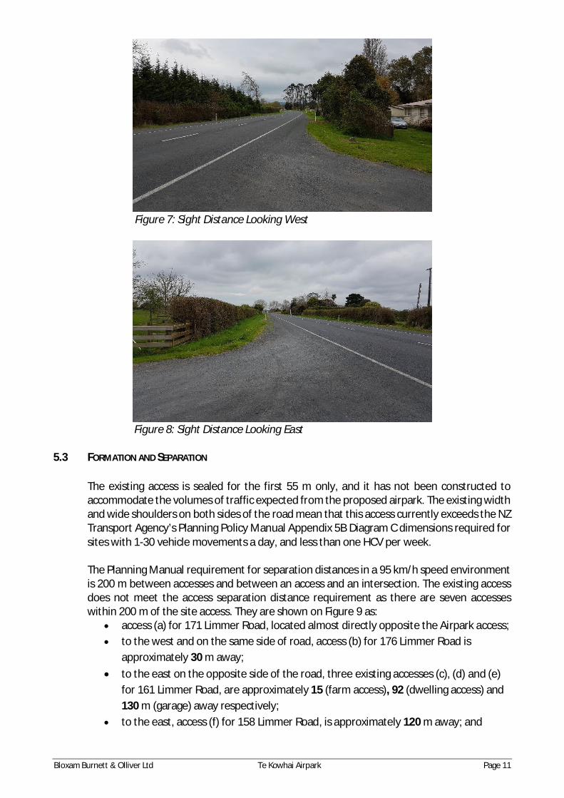
5.2 SIGHT DISTANCE
The sight distances from the access are given in Table 1 and are shown in Figures 7 and 8. The minimum sight distance at the existing access is 195 m to the west from the opposite side of the road. Slightly greater sight distances are achieved from a location 10 m to the east of the existing access (the proposed access location). The Planning Manual requires a sight distance of 214 m in a 93 km/h speed environment. The existing access location does not meet this requirement, however positioning the proposed new access approximately 10 m to the east of the existing access, will overcome this issue. The achievable sight distances for both the existing access and the proposed new access are summarised in Table 1.
Table 1: Sight Distances
Location Direction Side of Road Sight Distance
Operating Speed
Required Sight Distance
Existing Access
To the west Access 220 m
93 km/h 214 m Opposite 195 m
To the East Access 290 m
86 km/h 190 m Opposite 310 m
Proposed New Access
To the west Access 235 m
93 km/h 214 m Right turn bay 215 m
To the East Access 270 m
86 km/h 190 m Right turn bay 300 m
Bloxam Burnett & Olliver Ltd Te Kowhai Airpark Page 11
Figure 7: Sight Distance Looking West
Figure 8: Sight Distance Looking East
5.3 FORMATION AND SEPARATION
The existing access is sealed for the first 55 m only, and it has not been constructed to accommodate the volumes of traffic expected from the proposed airpark. The existing width and wide shoulders on both sides of the road mean that this access currently exceeds the NZ Transport Agency’s Planning Policy Manual Appendix 5B Diagram C dimensions required for sites with 1-30 vehicle movements a day, and less than one HCV per week. The Planning Manual requirement for separation distances in a 95 km/h speed environment is 200 m between accesses and between an access and an intersection. The existing access does not meet the access separation distance requirement as there are seven accesses within 200 m of the site access. They are shown on Figure 9 as:
access (a) for 171 Limmer Road, located almost directly opposite the Airpark access; to the west and on the same side of road, access (b) for 176 Limmer Road is
approximately 30 m away; to the east on the opposite side of the road, three existing accesses (c), (d) and (e)
for 161 Limmer Road, are approximately 15 (farm access), 92 (dwelling access) and 130 m (garage) away respectively;
to the east, access (f) for 158 Limmer Road, is approximately 120 m away; and

Bloxam Burnett & Olliver Ltd Te Kowhai Airpark Page 12
to the west, the double access (g) for 185 and 187 Limmer Road is approximately 126 m away.
The closest intersection (Hawksgrip Road) is more than 500 m east to the existing access.
Figure 9: Adjacent Accesses
6.0 Trip Generation 6.1 PERMITTED BASELINE
The existing airfield is currently used for private air trips and flying lessons. Trip generation information provided by the Applicant indicates that the existing site generates, on average, approximately 30 vpd, with a summer average peak of 40 vpd.
6.2 TRIP GENERATION
The proposal for the site includes 45 apartments and 87 residential lots of 2,500 m2. There will also be a 225 m2 GFA café, 300 m2 GFA of retail, a 300 m2 community facility and an expansion of existing airpark operations. As there are no facilities quite like this in New Zealand, there is no readily available trip generation data from which to base trip generation calculations. However, the concept is similar to the Hampton Downs Racetrack apartments, although these apartments sill require people to drive to them. The Applicant has indicated that they see the 45 apartments operating largely as weekend/holiday accommodation for flying enthusiasts who fly their planes either to or from the site. There may also be some local flying enthusiasts who choose to live on site, as a result the 87 residential lots would operate more like typical residential lots. On this basis, the following assumptions have been made to calculate trip generation of the proposal:
(d)161 Limmer Rd Dwelling access
(b)176 Limmer Rd Access
Proposed Airpark Access
(a) 171 Limmer Rd Access
(c)161 Limmer Rd Farm Access
(e)161 Limmer Rd Garage access
(f)158 Limmer Rd Access
(g)185-187 Limmer Rd Access
Bloxam Burnett & Olliver Ltd Te Kowhai Airpark Page 13
Approximately 50% (70% used for sensitivity testing) of the 45 apartments will be occupied during the week. Occupied apartments will have trip generation rates similar to those of a typical apartment;
The 87 country living lots will have trip generation of a typical residential unit and will be 100% occupied;
The airfield zone will have similar trip generation to the existing airfield with additional trip generation commensurate with the increase in size of the airfield (to be doubled);
The commercial zone will have a trip generation rate of typical similar activities; Approximately 20% of trips to the retail and café are expected to be internal Airpark
trips; and The community facility has been assessed as only generating internal trips as it is
intended to service the community living at the airpark, rather than being a destination that could generate external trips.
It is noted that the expected 50% occupancy rate of the apartments is based on the Applicant’s industry experience. The 70% occupancy rate used in sensitivity test is based on typical hotel occupancy rates in Waikato and Hamilton area. This figure is considered conservative as holiday homes tend to have a lower occupancy rate compared to hotels. Trip generation data has been sourced from the New Zealand Trips and Parking database and has been compared with other standard trip generation databases. For a residential unit, the predicted trip generation rate is 10.7 vpd per unit, and 1.3 per unit during the peak hour. For an apartment, the predicted trip generation rate is 6.8 vpd per unit and 0.8 per peak hour. However, given the rural location of the site, a residential lot trip generation rate has also been adopted for the apartments. The typical trip generation rate for a café is 73.3 vpd per 100 m2 GFA and 18 trips per peak hour per 100 m2 GFA. The typical trip generation for retail is approximately 100 vpd per 100 m2 GFA and 15.3 trips per peak hour per 100 m2 GFA. The airpark currently generates a peak season average of 43 vpd. The proposed development is expected to double the trip numbers solely associated with the airpark, bring the peak season daily average up to 86 vpd. It is assumed that 40% of these trips (34 trips) will occur in each of the peak hours.
The fully established Airpark is predicted to generate between 245-257 trips in the peak hour, and between 1,629-1,726 vpd. All relevant trip generation data is summarised in Tables 2 and 3.

Bloxam Burnett & Olliver Ltd Te Kowhai Airpark Page 14
Table 2: Airpark Peak Hour Trip Generation
Land Use Peak Hour Trip Generation Rate
Number/GFA
Typical Occupancy/T
rips
Weekday peak hour trip generation (trips per hour)
Residential / Country living lots 1.3 per dwelling 87 100% 113
Residential Apartments 1.3 per dwelling 45 50%/70% 29/41
Café to 18 per 100 m2 GFA 225 m2 80% 32
Retail 15.3 per 100 m2 GFA 300 m2 80% 37
Airpark Twice of the existing 17.2 200% 34
Total 245/257 vph
Table 3: Airpark Daily Trip Generation
Land Use Peak Hour Trip Generation Rate
Number/GFA
Typical Occupancy
/Trips
Weekday peak hour trip generation (trips per hour)
Residential / Country living lots 10.7 per dwelling 87 100% 931
Residential Apartments 10.7 per dwelling 45 50%/70% 240/337
Café to 73.3 per 100 m2 GFA 225 m2 80% 132
Retail 100 per 100 m2 GFA 300 m2 80% 240
Airpark Twice of the existing 43 200% 86
Total 1,629/1,726
7.0 Airpark Access
The existing access is unsuitable for the predicted increase in traffic volume expected from the Airpark development. Instead, it is proposed that a new access road (the Access Road) is constructed to service the Airpark. The cross section of the Access Road should comply with Table 4: Access and Road Performance Standards of Appendix A: Traffic of the Waikato District Plan. Based on the predicted traffic volumes, this Access Road is required to meet the “Local Road” standard. To achieve suitable sight distances, it is recommended that the proposed Access Road is located approximately 10 m east (centreline to centreline) of the existing access. This will

Bloxam Burnett & Olliver Ltd Te Kowhai Airpark Page 15
provide the new access with sufficient sight distances and compliance with the NZ Transport Agency Planning Manual. The proposed location and layout is shown in Figure 10 and in Appendix B. The proposed Access Road intersection will include a right turn pocket within a central flush median constructed in accordance with MOTSAM Part 2 Figure 3.28: Marking for Flush Medians at ‘T’ Intersections. This design has been chosen instead of Figure 2.35: Right Turn Bays in Rural Areas, as the flush median design provides increased sight distance and separate waiting area for vehicles turning right into accesses on the opposite side of the road while allowing through traffic to safely pass waiting vehicles. The flush median layout is based on the Figure 2.35 requirement for a 90 km/h operating speed. It allows a 3.5 m wide right turn flush median and 146 m long tapers. Furthermore, adequate width (greater than 6 m between the edge of seal and far side of the flush median), is provided by shoulder widening at all adjacent accesses for vehicles turning right into these accesses. The main difference between designing this site as a flush median with a right turn pocket instead of a rural right turn bay, is the absence of double yellow lines on the proposed access side of the road. While it is illegal to overtake on a flush median, the presence of double yellow lines, and the advance warning yellow lines, reinforces this fact to motorists. With consideration of the absence of the double yellow lines in the Access Road intersection design, it is recommended that the associated risk be mitigated through the placement of special general information signs which are similar to an IG-6 stating “No overtaking on flush median”. Permission to use these signs is to be sought from the NZ Transport Agency.
Figure 10: Proposed Access Design It is considered that the proposed design for the Access Road intersection adequately mitigates the separation distance issues for the following reasons: The flush median and shoulder widening will allow through traffic to safely pass any
slowing down left turning vehicles into accesses within 100 m of the proposed Access Road intersection. Therefore, the left turning vehicles and through traffic manoeuvre around each other safely.

Bloxam Burnett & Olliver Ltd Te Kowhai Airpark Page 16
The flush median and shoulder widening will also provide improved sight lines and a safe waiting area for right turning vehicles in the vicinity of the Access Road intersection, allowing through traffic to safely pass waiting right turn vehicles.
The farm access (d) shown on Figure 9 is expected to generate a minor number of traffic movements and therefore is not considered as a significant conflict point.
Waiting right turn vehicles at the Access Road intersection and the opposite access will restrict each other’s sight distances. This issue is mitigated by the flush median, together with the curves in Limmer Road in either direction, which allows waiting traffic to see approaching traffic.
While the increase in traffic from the Airpark will increase the potential for sight line restrictions from right turning vehicles, this issue is mitigated by the increased pavement width provided in this area, allowing for safer turning movements into all accesses.
For these reasons, the effects of this access are considered to be appropriately mitigated. A left turn slip lane is not recommended for the Access Road intersection as the majority of traffic is likely to access the site from Hamilton, and traffic volumes approaching from the west are expected to be low. Furthermore, left turn slip lanes have the potential to cause safety issues by obscuring the visibility of through vehicles on the main road to a driver at the stop line of the minor road. The Planning Manual Diagram E left turn shoulder widening is incorporated in the intersection design. It is recommended that the detailed design of the Airpark access and Access Road to include street lighting in accordance with AS/NZS 1158 series – Lighting for Roads and Public Spaces. On the basis of the above discussion, it is considered that the proposed concept design for the Airpark access will adequately mitigate any adverse traffic or safety effects generated by the proposed development.
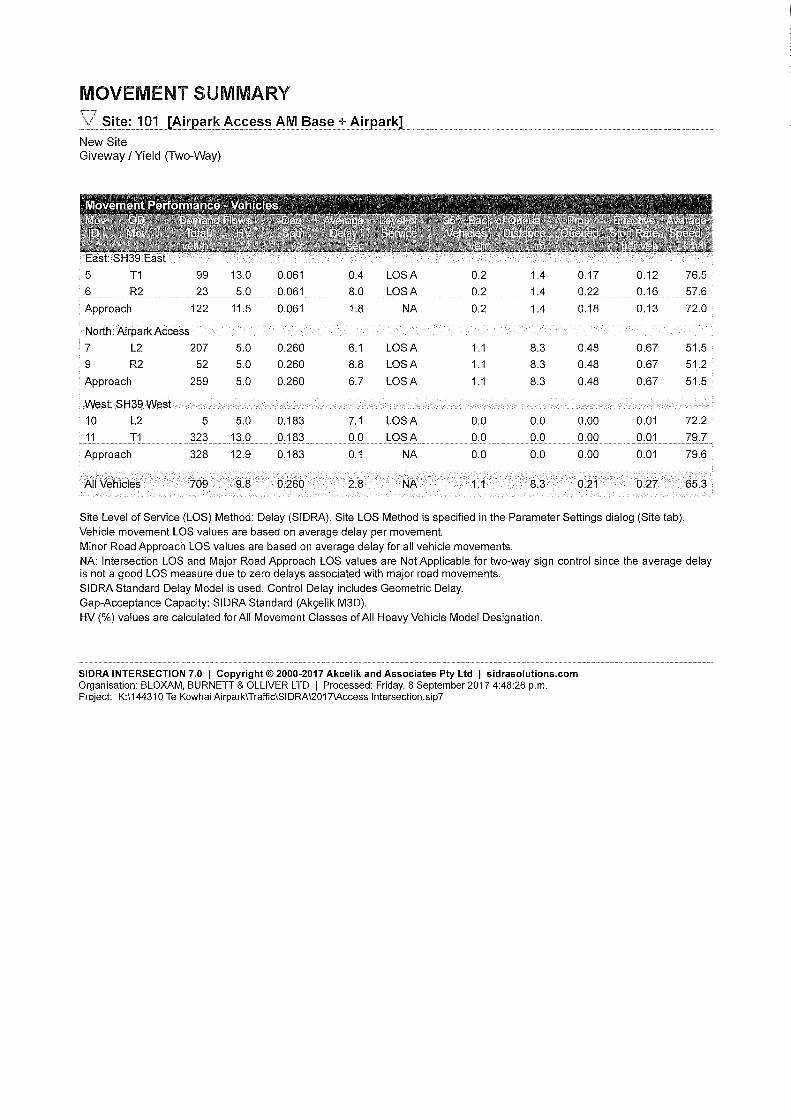
8.0 Airpark Access Performance
It is predicted that traffic using the proposed access will predominantly travel between Hamilton City and the Airpark either to and from work during the week; or to access facilities and service available in the City or at the Airpark. The fastest route into Hamilton is to turn left out of the site onto SH39. It is estimated that 20% of traffic may turn right onto SH39 to head to Te Kowhai or south to Whatawhata towards Raglan. This relatively low attraction rate is considered appropriate given that Te Kowhai does not have any significant retail or commercial facilities. It is predicted that 90% of traffic will be exiting the site in the AM peak and entering in the PM peak. These splits have been used to calculate turning volumes of the Airpark traffic. The NZ Transport Agency’s traffic counts indicate that the peak hour for traffic on Limmer Road is between 7-8 am (326 vehicles per hour) and 5-6 pm (395 vehicles per hour). Based on this, a SIDRA model of the access is created to assess the traffic effects of the proposed Airpark. The modelling considered future growth by applying a 1% annual increase rate of traffic on Limmer Road for up to year 2042. This growth rate was based on traffic volume changes on SH39 south of the Horotiu Road intersection over the last five years. The location south of Horotiu Road has been chosen as the area north of Horotiu Road has only been a

Bloxam Burnett & Olliver Ltd Te Kowhai Airpark Page 17
state highway since 2013 and therefore does not have adequate record of traffic volumes history. The results of SIDRA modelling are summarised in Table 4 with full results included in Appendix E. Assessments have also included a sensitivity test with a conservative 70% occupancy of the 45 apartments. Overall the access performs well with no movement worse than LoS B, even in the 2042 peak periods with 70% occupancy of the apartments. The LoS on SH39 is not affected with through movements operating at LoS A and turning movements into the Airpark also operating at LoS A, even in the 2042 peak periods.
Table 4: SIDRA Summary Airpark Access Intersection
Peak Period LoS for worst
movement
Average Delay for the worst movement
(seconds)
Degree of Saturation for the worst movement
AM Existing + Airpark A 8.8 0.260
2042 + Airpark A 9.8 0.281
PM Existing + Airpark B 12.1 0.300
2042 + Airpark B 13.9 0.333
8.1 WIDER NETWORK EFFECTS
To provide for traffic modelling for the wider road network effects, traffic surveys were undertaken at the Horotiu Road and Te Kowhai Road intersections. These intersections were surveyed on two days; Tuesday 11th April and Wednesday 12th April 2017 in both the morning and evening peak periods. The surveyed traffic flows were used to build a SIDRA models of the intersections. As with the SH39/Limmer Road traffic, an annual growth rate of 1% was used to create models for the 2042 peak periods. The results of this modelling indicate that these intersections currently perform well with the worst movement at LoS B with Airpark traffic. Modelling for future years shows that Horotiu Road intersection operates at LoS C in the year 2042 for the right turn out of Horotiu Road, with a 16 second average delay in the peak period. This delay is considered acceptable.
Table 5: SIDRA Summary Horotiu Road Intersection Peak Period LoS
for worst movement
Average Delay for the worst movement
(seconds)
Degree of Saturation For the worst movement
AM Existing + Airpark A 9.2 0.207
2042 + Airpark B 11.5 0.300
PM Existing + Airpark B 11.1 0.327
2042 + Airpark C 16.0 0.489

Bloxam Burnett & Olliver Ltd Te Kowhai Airpark Page 18
Table 6: SIDRA Summary Te Kowhai Road Intersection Peak Period LoS
For worst movement
Average Delay for the worst movement
(seconds)
Degree of Saturation For the worst movement
AM Existing A 9.1 0.249
2042 B 10.4 0.284
PM Existing B 10.9 0.273
2042 B 13.3 0.321
As both intersections continue to operate at a high-level of service, even with the addition of traffic from the proposed Airpark and a 1% annual growth rate through to 2042, the impacts on the surrounding road network are considered to be no more than minor.
9.0 Parking
The Waikato District Plan Appendix A: Traffic has parking requirements in its Table 1. For a dwelling, the requirement is 1 car parking space per bedroom. As the proposed Te Kowhai Airfield development is only in its concept stage, the number of units and design of individual units have not been finalised. Therefore, it is considered that parking requirements should be met in the detailed design phase and if requirements cannot be met, a separate Resource Consent should be sought. It is noted that there are currently no parking requirements in the Waikato District Plan for an airfield related activity. Parking for the airfield should be determined in the detailed design phase using relevant industry knowledge and experience once the exact use and size of the proposed airfield is known.
10.0 Travel Demand Management
9.1 TRAVEL DEMAND MANAGEMENT (TDM) OPPORTUNITIES The NZ Transport Agency recognises that travel demand cannot continue to be met with the unlimited supply of road infrastructure. Travel Demand Management refers to methods to reduce the need to travel as well as reducing short private vehicle trips. TDM is about providing greater choice of sustainable transportation options to the public, thereby spreading all trips over more travel modes and over more times of the day, or removing the need to travel at all. TDM therefore also helps to reduce the impact on the environment by reducing the level of carbon produced by travel. While the location of the proposed airpark is not well suited to multi-modal transport, the very nature of the activity itself will reduce vehicle trips on the network. The Te Kowhai Airpark will allow apartment owners to fly to and from the site without needing to make any vehicle trips. Prior to the construction of the apartments, anyone wanting to fly to or from the site would have to make a minimum of two vehicle trips, as well as having to find
Bloxam Burnett & Olliver Ltd Te Kowhai Airpark Page 19
accommodation elsewhere in the Waikato region and / or Hamilton City. Under the proposal, majority of the needs will be provided for on site, reducing the required private vehicle trips on the road network. Promoting the use of easy air travel with accommodation on site also has the potential to reduce the need for some long-distance vehicle trips, as plane owners from further afield can elect to fly and stay on site when visiting Hamilton and nearby areas, rather than driving long distances.
11.0 Signage The Applicant intends for all signage to be provided on private property. The signage will either meet the Council’s requirements or be approved by the Council via resource consent process. Details of the proposed signage will be provided at the detailed design stage of this development.
12.0 Consultation with the NZ Transport Agency Preliminary consultation has been undertaken regarding options for the proposed access to SH39/Limmer Road. Preliminary feedback from the NZ Transport Agency concerned the following: A better understanding of the size and scale of the commercial area; Connectivity to Te Kowhai, specifically the potential future provision of a walking and
cycling path through to Te Kowhai township; The addition of Diagram E left turn deceleration shoulder widening to any access
concept design; Confirmation of sight distance, lighting and signage at the proposed access; Information regarding any other site access; and An understanding of discussions held with the Council.
The original draft report has been updated to reflect these comments and address any concerns raised.
13.0 Conclusion
Based on this report Bloxam, Burnett and Olliver make the following conclusions:
The existing access is to be relocated and upgraded to a “Local Road” standard with a T intersection onto State Highway 39 to accommodate traffic from the proposed development. An access concept design is included in Appendix B, which addresses the potential safety issues with non-complying separation distances to nearby property accesses.
The existing airfield has a trip generation of approximately 30 vpd. Due to the unique nature of the proposal, there is no trip generation data available for similar development.

Bloxam Burnett & Olliver Ltd Te Kowhai Airpark Page 20
Based on some assumptions, the Airpark is expected to generate approximately 245 trips per weekday AM and PM peak hour.
SIDRA modelling of the proposed intersection shows that it performs well, up to year
2042 traffic flows on State Highway 39/Limmer Road using a 1% annual growth rate on actual surveyed traffic counts. The model indicates that the LoS for the worst movement (the right turn out of the airpark access) will operate at LoS B. All movements on SH39 continue to operate at LoS A under. Similarly, the Horotiu Road and Te Kowhai Road
intersections continue to operate at a high-level of service, with no movement operating at less than LoS C.
Parking requirements will be confirmed in the detailed design phase, and if requirements
cannot be met a separate Resource Consent should be sought.
14.0 Recommendations
Based on this report, Bloxam, Burnett and Olliver make the following recommendations:
The Applicant is to provide a walking and cycling connection from the site to the boundary of 721 Horotiu Road.
The existing access is to be relocated and upgraded to a “Local Road” intersection standard with State Highway 39/Limmer Road. The intersection should be designed in accordance with the preliminary design drawing provided in Appendix B.
Special general information signs similar to an IG-6 stating “No overtaking on flush median” are to be installed at both ends of the proposed flush median if approved by the NZ Transport Agency.
The new access road typical cross section and the number of car parking spaces should be determined in the detailed design, but these should comply with Appendix A: Traffic in the Waikato District Plan.
The detailed design of the Airpark access and Access Road is to include street lighting in accordance with AS/NZS 1158 series – Lighting for Roads and Public Spaces.
Airpark signage is to either meet the Waikato District Council requirements or be approved by the Council via resource consent process.

Appendix A
Airpark Indicative Layout


Appendix B
Intersection Concept Design


Appendix C
CAS Data


Appendix D
Indicative Operating Speed Measurements

Operating Speed Measurements
7/09/2017 From West From East 88 72 76 90 84 81 82 82 78 85 79 92 78 76 88 69 81 76 79 78 95 86 82 70 71 95 93 82 65 69 73 78 90 85 97 75 65 84 75 80 86 79 88 83 93 76 80 80 96 86 85th percentile 93 86 Required sight line 214 190
Appendix E
Flow Diagrams and SIDRA Results