tdot sr 28 draft ea - tva content/environment... · us 127/sr 28 improvements ii draft...
TRANSCRIPT
Document Type: EA-Administrative Record Index Field: Environmental Document
Transmitted Public/Agencies Project Name: TDOT SR 28 at Cumberland
Homesteads Project Number: 2010-36
US 127 / SR 28 IMPROVEMENTS FROM CLEVELAND STREET TO STATE ROUTE 68
DRAFT ENVIRONMENTAL ASSESSMENT Cumberland County, Tennessee
Prepared by: TENNESSEE VALLEY AUTHORITY
Knoxville, Tennessee
Cooperating Agency: U.S. ARMY CORPS OF ENGINEERS
Nashville, Tennessee
September 2014
To request further information, contact: Charles P. Nicholson NEPA Compliance
Tennessee Valley Authority 400 West Summit Hill Drive, WT 11D
Knoxville, TN 37902-1499 Phone: 865-632-3582 E-mail: [email protected]

This page intentionally left blank

Contents
Draft Environmental Assessment i
Table of Contents
CHAPTER 1 – PURPOSE AND NEED FOR ACTION ......................................................................... 1
1.1 Introduction .............................................................................................................................. 1 1.2 Decision to be Made ................................................................................................................ 1 1.3 Purpose of the Project .............................................................................................................. 1 1.4 Need for the Project ................................................................................................................. 3
1.4.1 Traffic and Level of Service Analysis ................................................................................ 3 1.4.2 Crash Analysis ................................................................................................................... 7 1.4.3 Traffic Safety...................................................................................................................... 7 1.4.4 Logical Termini and Independent Utility ............................................................................ 7 1.4.5 Consistency with Plans ...................................................................................................... 8
1.5 Scoping and Public Involvement .............................................................................................. 8 1.6 Necessary Permits or Licenses ............................................................................................... 8
CHAPTER 2 - ALTERNATIVES ......................................................................................................... 11
2.1 Alternative A – The No-Build (No Action) Alternative ............................................................ 11 2.2 Alternative B – The Build Alternative ..................................................................................... 11 2.3 Alternatives Considered but Eliminated From Further Discussion ........................................ 12 2.4 Identification of Mitigation Measures ...................................................................................... 13 2.5 The Preferred Alternative ....................................................................................................... 13
CHAPTER 3 – AFFECTED ENVIRONMENT AND ENVIRONMENTAL CONSEQUENCES ................................................................................................................. 14
3.1 Cultural Resources ................................................................................................................. 14 3.2 Water Quality and Aquatic Ecology ....................................................................................... 18 3.3 Wetlands ................................................................................................................................ 22 3.4 Floodplains ............................................................................................................................. 24 3.5 Vegetation and Wildlife .......................................................................................................... 25 3.6 Endangered and Threatened Species ................................................................................... 26 3.7 Parks, Natural Areas, and Recreation ................................................................................... 29 3.8 Air Quality ............................................................................................................................... 30 3.9 Land Use ................................................................................................................................ 31 3.10 Socioeconomics and Environmental Justice.......................................................................... 32 3.11 Cumulative Impacts ................................................................................................................ 32 3.12 Unavoidable Adverse Environmental Impacts ....................................................................... 33 3.13 Relationship of Short-Term Uses and Long-Term Productivity ............................................. 33 3.14 Irreversible and Irretrievable Commitments of Resources ..................................................... 33
CHAPTER 4 – LIST OF PREPARERS .............................................................................................. 35
CHAPTER 5 – LITERATURE CITED ................................................................................................. 37
List of Appendices
APPENDIX A – TVA NEPA COMPLIANCE OVERVIEW……………………………………..39
APPENDIX B – REGULATORY AGENCY CORRESPONDENCE…………………………..41

US 127/SR 28 Improvements
ii Draft Environmental Assessment
APPENDIX C – DRAFT MEMORANDUM OF AGREEMENT FOR IMPROVEMENTS TO STATE ROUTE 28, CUMBERLAND COUNTY, TENNESSEE ……………………..46
List of Tables
Table 1. 1995 and 2015 Average Daily Traffic (ADT) Volumes and Percent Trucks ............................................................................................................... 3
Table 2. 2014 and 2034 ADT and Percent Trucks .......................................................... 3 Table 3. Level of Service Description .............................................................................. 4 Table 4. Analysis Sections for Existing and No Build Conditions. See Figure
1 for the mapped locations of the segments. .................................................... 5 Table 5. Summary of Level of Service Analysis Results for 2014 Existing and
2034 No Build Alternative Conditions. See Figure 1 for the mapped locations of the segments.................................................................................. 6
Table 6. Summary of the LOS Analysis for the 2034 Build Alternative Condition ........................................................................................................... 7
Table 7. Endangered, threatened, and special concern species reported from Cumberland County. ....................................................................................... 26
List of Figures
Figure 1. The US 127 / SR 28 Project Area. Segments numbered 1 through 9 are listed in Tables 4 and 5. .............................................................................. 2
Figure 2. Proposed realignment of the US 127 – SR 68 intersection. ............................ 12 Figure 3. Streams and Wetlands in the US 127 project area. ........................................ 19 Figure 4. US 127 bridge over Byrd Creek. This view is looking upstream. ................... 20 Figure 5. US 127 bridge over Threemile Creek. This view is looking
upstream. ........................................................................................................ 21

Chapter 1 – Purpose and Need for Action
Draft Environmental Assessment 1
CHAPTER 1 – PURPOSE AND NEED FOR ACTION
1.1 Introduction
The Tennessee Department of Transportation (TDOT) proposes to widen 3.7 miles of US Highway 127 / State Route (SR) 281 and a connecting 0.5-mile segment of SR 68 in Cumberland County, Tennessee (Figure 1). This highway, presently a mix of 2- lane and 3-lane segments, would be widened to accommodate four travel lanes and a center turn lane. The intersection of US 127 and SR 68 would be rebuilt with a traffic signal
The proposed action would be funded entirely by the State of Tennessee. It is therefore not subject to the requirements of Section 4(f) of the U.S. Department of Transportation Act of 1966. It would require permits from the Tennessee Valley Authority (TVA) and the U.S. Army Corps of Engineers (USACE). These permitting actions by federal agencies are subject to the requirements of the National Environmental Policy Act (NEPA). This environmental assessment (EA) has been prepared by TVA to meet NEPA requirements. The USACE is a cooperating agency in the preparation of this EA. See Appendix A for more on TVA’s NEPA compliance process.
US 127 is a major north-south arterial route. It runs southward through the Sequatchie Valley to Pikeville and Dunlap to Chattanooga, and northward through Clarkrange and Jamestown into Kentucky.
1.2 Decision to be Made
The proposed roadway improvements require approval by the Tennessee Valley Authority (TVA) under Section 26a of the TVA Act and by the U.S. Army Corps of Engineers (USCOE) under Section 404 of the Clean Water Act for the resulting construction activities in streams and wetlands. The affected streams are tributaries of the Tennessee River (Emory River watershed) and include Byrd Creek, Threemile Creek, Onemile Creek, and unnamed tributaries to each stream.
1.3 Purpose of the Project
The purpose of the proposed action, as defined by TDOT, is to improve US 127 and SR 68 to address geometric, structural, and operational deficiencies within the project limits. The project would improve access to Crossville from the south and would improve access to the Cumberland Homesteads, Cumberland Mountain State Park, and Bear Trace Golf Course. The proposed improvements would also support potential economic and community development.
1 For purposes of brevity and because this roadway is better known to the public as US 127 than SR 28, it is referred to as US 127 in this EA.

US 127/SR 28 Improvements
2 Draft Environmental Assessment
Figure 1. The US 127 / SR 28 Project Area. Segments numbered 1 through 9 are listed in Tables 4 and 5.

Chapter 1 – Purpose and Need for Action
Draft Environmental Assessment 3
1.4 Need for the Project
The TDOT Bureau of Planning and Development prepared an Advanced Planning Report (APR) for the project in November 1994. The purpose of the APR was to evaluate the feasibility of improving US 127 south of Crossville. The APR also included an evaluation of the triangular intersection of US 127 and SR 68. The APR concluded that the existing highway, through the study limits, had geometric, structural, and operational deficiencies. The structural deficiencies included inadequate bridges over Byrd Creek and Threemile Creek. The geometric and operational deficiencies were highlighted by the highway having a crash rate (i.e., crashes per one million vehicle-miles) of 2.36, which was higher than the statewide average rate of 1.74 for the same period. In addition, the existing and projected traffic volumes indicated the need for a four lane highway. To address these deficiencies the APR recommended the following improvements:
Widen US 127 from two lanes to four lanes with a center turn lane along the existing alignment through the study limits;
Widen SR 68 to the same typical section from US 127 east through the intersection of Deep Draw Road;
Modify the triangle intersection at US 127 and SR 68 and install a signal;
Reduce shoulder widths along the highway in Crossville to minimize impacts; and
Design speeds should range between 40 and 45 miles per hour.
1.4.1 Traffic and Level of Service Analysis The APR included 1995 Base Year and projected 2015 Design Year average daily traffic (ADT) volumes and percent trucks (Table 1).
Table 1. 1995 and 2015 Average Daily Traffic (ADT) Volumes and Percent Trucks
Year ADT Range Percent Trucks
1995 6,050 – 12,390 7 – 8 %
2015 9,680 – 21,460 7 – 8 %
In 2013, the TDOT Project Planning Division updated the traffic analysis to include 2014 Base Year and 2034 Design Year ADT volumes and percent trucks (Table 2). The lower ADT was attributed to a lower than expected growth rate in the corridor.
Table 2. 2014 and 2034 ADT and Percent Trucks
Year ADT Range Percent Trucks
2014 6,400 – 12,660 5 – 8 %
2034 7,640 – 15,210 5 – 8 %
To determine how well traffic operates on the existing roadway network, a level-of-service (LOS) analysis was conducted. LOS is a measure of expected travel conflicts, delay, driver
US 127/SR 28 Improvements
4 Draft Environmental Assessment
discomfort, and congestion. LOS measurements rate how well traffic operates on a given transportation facility.
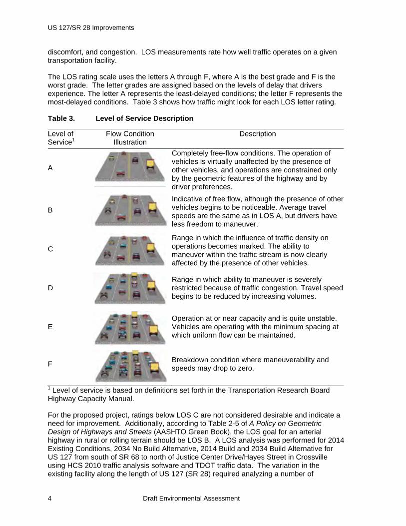
The LOS rating scale uses the letters A through F, where A is the best grade and F is the worst grade. The letter grades are assigned based on the levels of delay that drivers experience. The letter A represents the least-delayed conditions; the letter F represents the most-delayed conditions. Table 3 shows how traffic might look for each LOS letter rating.
Table 3. Level of Service Description
Level of Service1
Flow Condition Illustration
Description
A
Completely free-flow conditions. The operation of vehicles is virtually unaffected by the presence of other vehicles, and operations are constrained only by the geometric features of the highway and by driver preferences.
B
Indicative of free flow, although the presence of other vehicles begins to be noticeable. Average travel speeds are the same as in LOS A, but drivers have less freedom to maneuver.
C
Range in which the influence of traffic density on operations becomes marked. The ability to maneuver within the traffic stream is now clearly affected by the presence of other vehicles.
D
Range in which ability to maneuver is severely restricted because of traffic congestion. Travel speed begins to be reduced by increasing volumes.
E
Operation at or near capacity and is quite unstable. Vehicles are operating with the minimum spacing at which uniform flow can be maintained.
F
Breakdown condition where maneuverability and speeds may drop to zero.
1 Level of service is based on definitions set forth in the Transportation Research Board Highway Capacity Manual.
For the proposed project, ratings below LOS C are not considered desirable and indicate a need for improvement. Additionally, according to Table 2-5 of A Policy on Geometric Design of Highways and Streets (AASHTO Green Book), the LOS goal for an arterial highway in rural or rolling terrain should be LOS B. A LOS analysis was performed for 2014 Existing Conditions, 2034 No Build Alternative, 2014 Build and 2034 Build Alternative for US 127 from south of SR 68 to north of Justice Center Drive/Hayes Street in Crossville using HCS 2010 traffic analysis software and TDOT traffic data. The variation in the existing facility along the length of US 127 (SR 28) required analyzing a number of

Chapter 1 – Purpose and Need for Action
Draft Environmental Assessment 5
individual sections of the existing roadway. The characteristics of the existing highway are shown in Table 4.
Table 4. Analysis Sections for Existing and No Build Conditions. See Figure 1 for the mapped locations of the segments.
Segment Section Length (Miles) Distinguishing Characteristic
1 US 127 south of SR 68 to SR 68 intersection
0.21 2-lanes with 10' shoulders
2* US 127 at SR 68 intersection to County Road (Old Homestead)
0.1585 2-lanes with 10' shoulders
2* US 127 at County Road to 750' South of Byrds Creek Lane
0.3119 3-lanes - 2 southbound with 5' shoulder and 1 northbound lane with 9' shoulder
2* US 127 south of Byrds Creek Lane to south of East Lake Road
0.6155 2-lanes with 9' shoulders
3 US 127 south of East Lake Road to 1300' south of Park Trace Drive
0.2759 3-lanes - 2 northbound lanes with 5'shoulder and 1 southbound with 10'shoulder
4 US 127 south of Park Trace Drive tosouth of Malver Drive
0.5826 2-lanes with 9' shoulders
5 US 127 south of Malver Drive to north of Wilson Lane
0.1797 3-lanes with turn lane and 3' shoulders
6 US 127 north of Wilson Lane to north of Shepherd's Way
0.2023 2-lanes with 9' shoulders
7 US 127 north of Shepherd's Way (Miller Ave) to north of Dunbar
0.3 3-lanes with 2 westbound left turn lanes (45 mph) with 5' shoulders
8 US 127 at Dunbar Lane to north of Hayes Street
0.5041 3-lanes with 2 westbound left turn lanes (30 mph) with 2' shoulders
9 SR 68 from Deep Draw Road to US 127
0.4 2-lanes with 2’ shoulders
*These 3 segments were grouped together for analysis. Northbound and southbound facilities were different.
Those segments with distinct northbound or southbound features were analyzed by direction. The peak hour assumed a 55-45 percent directional split. Specific morning and evening peak hours were not assigned since the split was fairly even and the directional distribution for the peak hours varied along the study limits. Homestead Elementary School near the end of the project created a southbound morning generator. Closer toward Crossville, the heavier morning movement is northbound into town. For the purpose of the study, it is assumed that 55 percent represents the peak hour in a particular direction and 45 percent would represent traffic in the opposite direction during the same peak.
Table 5 shows the results of the LOS analyses for the 2014 existing and 2034 No Build Alternative conditions. The results of the LOS analysis indicates US 127 (SR 28) through the study limits currently operates at a LOS D or E and will operate at a LOS D or E under the 2034 No Build Alternative conditions.

US 127/SR 28 Improvements
6 Draft Environmental Assessment
Table 5. Summary of Level of Service Analysis Results for 2014 Existing and 2034 No Build Alternative Conditions. See Figure 1 for the mapped locations of the segments.
Segment Section 2014 Existing LOS
2034 No Build Alternative LOS
1 US 127 south of SR 68 to SR 68 intersection
D/D D/D
2 US 127 at SR 68 intersection to County Road (Old Homestead) to south of East Lake Road (includes SB passing lane)
NB D/D SB E/D
NB E/D SB E/E
3 US 127 south of East Lake Road to 1300’ south of Park Trace Drive (includes NB climbing lane)
NB D/D SB E/D
NB E/D SB E/E
4 US 127 south of Park Trace Drive to south of Malver Drive
D/D D/D
5 US 127 south of Malver Drive to north of Wilson Lane
D/D E/E
6 US 127 north of Wilson Lane to north of Shepherd's Way
D/D E/E
7 US 127 north of Shepherd's Way (Miller Ave) to north of Dunbar Lane
D/D E/E
8 US 127 Dunbar Lane to north of Hayes Street
E/E E/E
9 SR 68 from Deep Draw Road to US 127 intersection
D/D D/D
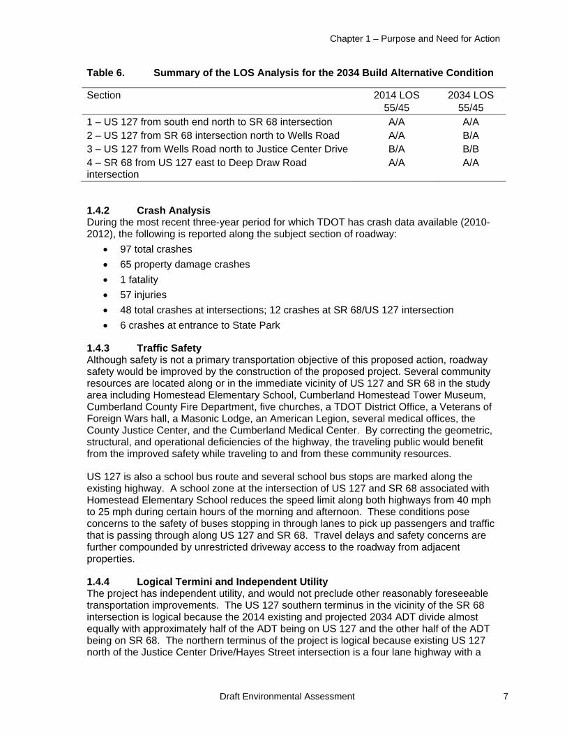
For the proposed 2034 Build Alternative conditions, the project was evaluated as a four lane highway with a center turn lane. The only change in this cross section would be from Wells Road to the north end of the project. This section would not include shoulders and would have a design speed of 30 mph rather than 45 mph. Because of the difference in traffic volumes, the sections of US 127 south of the SR 68 intersection and SR 68 from US 127 east to Deep Draw Road were analyzed separately. The analysis assumed the 55/45 percent direction split during the peak hour. Table 6 shows the LOS analysis results for the proposed 2034 Build Alternative condition. The results of the LOS analysis (Table 6) for the 2034 Build Alternative condition indicate that US 127 and SR 68 would operate at LOS A or B.
Chapter 1 – Purpose and Need for Action
Draft Environmental Assessment 7
Table 6. Summary of the LOS Analysis for the 2034 Build Alternative Condition
Section 2014 LOS 55/45
2034 LOS 55/45
1 – US 127 from south end north to SR 68 intersection A/A A/A 2 – US 127 from SR 68 intersection north to Wells Road A/A B/A 3 – US 127 from Wells Road north to Justice Center Drive B/A B/B 4 – SR 68 from US 127 east to Deep Draw Road intersection
A/A A/A
1.4.2 Crash Analysis During the most recent three-year period for which TDOT has crash data available (2010-2012), the following is reported along the subject section of roadway:
97 total crashes
65 property damage crashes
1 fatality
57 injuries
48 total crashes at intersections; 12 crashes at SR 68/US 127 intersection
6 crashes at entrance to State Park
1.4.3 Traffic Safety Although safety is not a primary transportation objective of this proposed action, roadway safety would be improved by the construction of the proposed project. Several community resources are located along or in the immediate vicinity of US 127 and SR 68 in the study area including Homestead Elementary School, Cumberland Homestead Tower Museum, Cumberland County Fire Department, five churches, a TDOT District Office, a Veterans of Foreign Wars hall, a Masonic Lodge, an American Legion, several medical offices, the County Justice Center, and the Cumberland Medical Center. By correcting the geometric, structural, and operational deficiencies of the highway, the traveling public would benefit from the improved safety while traveling to and from these community resources.
US 127 is also a school bus route and several school bus stops are marked along the existing highway. A school zone at the intersection of US 127 and SR 68 associated with Homestead Elementary School reduces the speed limit along both highways from 40 mph to 25 mph during certain hours of the morning and afternoon. These conditions pose concerns to the safety of buses stopping in through lanes to pick up passengers and traffic that is passing through along US 127 and SR 68. Travel delays and safety concerns are further compounded by unrestricted driveway access to the roadway from adjacent properties.
1.4.4 Logical Termini and Independent Utility The project has independent utility, and would not preclude other reasonably foreseeable transportation improvements. The US 127 southern terminus in the vicinity of the SR 68 intersection is logical because the 2014 existing and projected 2034 ADT divide almost equally with approximately half of the ADT being on US 127 and the other half of the ADT being on SR 68. The northern terminus of the project is logical because existing US 127 north of the Justice Center Drive/Hayes Street intersection is a four lane highway with a
US 127/SR 28 Improvements
8 Draft Environmental Assessment
center turn lane. The project would extend this four-lane with center turn lane configuration to the US 127 / SR 68 intersection. The term independent utility means that the project is usable even if no additional future transportation improvements in the area are made. This project demonstrates independent utility since it is not dependent upon other unfunded projects or those currently in early stages of project development. The proposed improvements to US 127 do not require the construction of any additional projects to be fully usable as a stand-alone project.
1.4.5 Consistency with Plans The proposed project was listed in the Accelerated Primary Highway Plan, a component of the 1986 Better Roads Program created by the 94th Tennessee General Assembly. The project has also received approval of the Crossville Regional Planning Commission and is included in the Tennessee Department of Transportation’s (TDOT) Fiscal Year 2014 through 2017 Transportation Improvement Program (STIP). The project is identified in the current STIP as Project No. #141801 and TDOT PIN #101044.00.
1.5 Scoping and Public Involvement
The US 127 / SR 68 project has a long history of public involvement. TDOT held a public design hearing on October 14, 1999. In 2002, this project became one of the 15 projects that the University of Tennessee Center for Transportation Research studied to determine if these projects as proposed were necessary. As part of this study, a public listening session was held in May, 2003 and attended by 48 people. In response to the finding of the study, TDOT modified the project to better reflect the needs of local residents and motorists and eliminated a portion of the project on SR 68.
In 2003, TDOT announced that it would use the Context Sensitive Solutions (CSS) process to evaluate the proposed project. The CSS process is a method used by TDOT to plan, design, construct, maintain and operate its transportation system in order to establish and achieve transportation, community, and environmental goals. A Citizens Resource Team was formed and met several times and presented recommendations to TDOT in 2005. These recommendations included the establishment of a Design Enhancement Team to develop additional detailed recommendations to address impacts to the Cumberland Homesteads Historic District. Some of these recommendations were adopted by TDOT.
TDOT first applied for the required TVA Section 26a and USCOE Section 404 permits in May 2006. TVA and USCOE issued Joint Public Notice No. 06-143 of the permit applications in January 2007. Comments received in response to this public notice have been considered in TDOT’s design of the project and in the development of this EA.
TDOT submitted a revised application for the Section 26a and Section 404 permits in March, 2010. TVA issued another public notice in December 2010 and held a joint public meeting with TDOT on January 20, 2011. Approximately 20 people attended the public meeting. TVA and TDOT received several comments during and shortly after the meeting. These comments have been considered in TDOT’s design of the project and in the development of this EA.
1.6 Necessary Permits or Licenses
The proposed alterations to streams and wetlands would require a permit issued by the USACE under Section 404 of the Clean Water Act (CWA) and a TVA Section 26a permit.

Chapter 1 – Purpose and Need for Action
Draft Environmental Assessment 9
They would also require an Aquatic Resource Alteration Permit (ARAP) issued by the Tennessee Department of Environment and Conservation (TDEC). The ARAP permit would include the State’s certification under Section 401 of the CWA that the issuance of the federal Section 404 and Section 26a permits would not result in a violation of state water quality standards.
Because the proposed highway construction would disturb more than one acre of land, it would require a Construction Stormwater Permit issued by the TDEC under the National Pollutant Discharge Elimination System. This permitting process requires the development and implementation of a site-specific Stormwater Pollution Prevention Plan.

Chapter 2 – Alternatives
Draft Environmental Assessment 11
CHAPTER 2 - ALTERNATIVES
This chapter describes the alternatives evaluated in this EA.
2.1 Alternative A – The No-Build (No Action) Alternative
Under the No-Build Alternative, TVA would not issue the requested Section 26a approval TDOT would not rebuild the section of US 127 and SR 68 as presently proposed. Routine maintenance would continue as needed. Historic properties, streams, wetlands, and other resources in the project area would not be affected by the highway construction. These resources would be affected by other activities, including the potential development of the remaining undeveloped areas along US 127 and the affected portion of SR 68. Selection of this alternative would not meet TDOT’s project purpose to improve US 127 / SR 68 by addressing geometric, structural, and operational deficiencies within the project limits.
2.2 Alternative B – The Build Alternative
Under this alternative, TVA and USCOE would issue the Section 26a and Section 404 permits to TDOT for the proposed fills and other modifications to streams and wetlands. TDOT would rebuild a 3.7 mile section of US 127 from Cleveland Street in Crossville to the US 127/SR 68 intersection. This section of US 127 would be rebuilt with four 12-ft travel lanes, a 12-ft two-way center turn lane, and two 0–10-ft shoulders with areas of curb and gutter. Between the US 127/SR 68 and the US 127/SR 392 intersections, the additional lanes would be constructed on the east side of the existing lanes. North of the US 127/SR 392 intersection, the new lanes would be added to both sides of the existing lanes.
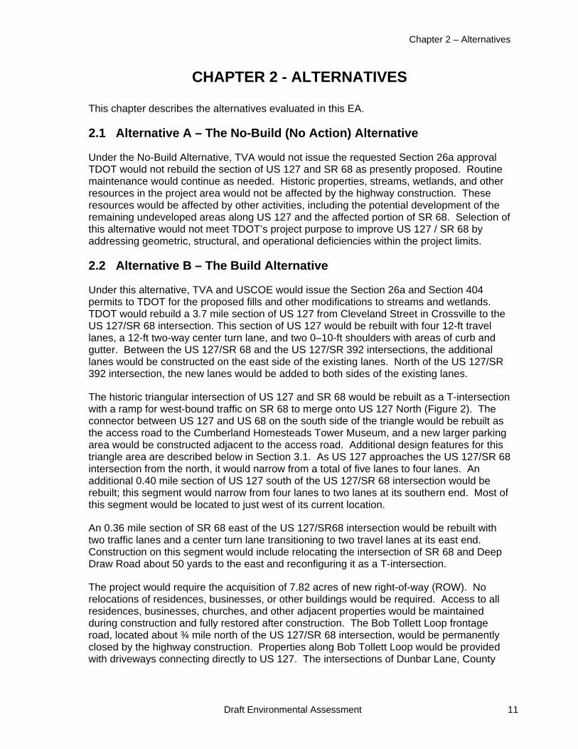
The historic triangular intersection of US 127 and SR 68 would be rebuilt as a T-intersection with a ramp for west-bound traffic on SR 68 to merge onto US 127 North (Figure 2). The connector between US 127 and US 68 on the south side of the triangle would be rebuilt as the access road to the Cumberland Homesteads Tower Museum, and a new larger parking area would be constructed adjacent to the access road. Additional design features for this triangle area are described below in Section 3.1. As US 127 approaches the US 127/SR 68 intersection from the north, it would narrow from a total of five lanes to four lanes. An additional 0.40 mile section of US 127 south of the US 127/SR 68 intersection would be rebuilt; this segment would narrow from four lanes to two lanes at its southern end. Most of this segment would be located to just west of its current location.
An 0.36 mile section of SR 68 east of the US 127/SR68 intersection would be rebuilt with two traffic lanes and a center turn lane transitioning to two travel lanes at its east end. Construction on this segment would include relocating the intersection of SR 68 and Deep Draw Road about 50 yards to the east and reconfiguring it as a T-intersection.
The project would require the acquisition of 7.82 acres of new right-of-way (ROW). No relocations of residences, businesses, or other buildings would be required. Access to all residences, businesses, churches, and other adjacent properties would be maintained during construction and fully restored after construction. The Bob Tollett Loop frontage road, located about ¾ mile north of the US 127/SR 68 intersection, would be permanently closed by the highway construction. Properties along Bob Tollett Loop would be provided with driveways connecting directly to US 127. The intersections of Dunbar Lane, County
US 127/SR 28 Improvements
12 Draft Environmental Assessment
Figure 2. Proposed realignment of the US 127 – SR 68 intersection.
Seat Road, and driveways of a few businesses and residences with US 127 or US 68 would be realigned to intersect at 90-degree angles. Parts of the Old Highway Circle frontage road would be removed and East Lane would be extended to intersect directly with US 127. The Bob Tollett Loop frontage road would also be removed and the driveways for businesses and residences along it would be extended to intersect directly with US 127.
2.3 Alternatives Considered but Eliminated From Further Discussion
Over the history of this project, TDOT has proposed several alternative designs for the intersection of US 127 and SR 68 adjacent to the Cumberland Homesteads visitor center, tower, and school. These alternatives had various configurations of T-shaped intersections that would have eliminated the current historical triangular intersection. Some of these configurations would have relocated the sections of US 127 and SR 68 at the intersection onto all new rights-of-way. Others would have generally followed the current alignments of US 127 and SR 68 and replaced the current triangular intersection with a rotary or a modified triangular intersection. In early 2004, TDOT convened a resource team comprised of representatives from TDOT, other agencies, and local citizens, businesses, and organizations to review alternative designs for the intersection through a Context Sensitive Solutions process. TDOT considered the findings of the resource team and eliminated the alternative designs because of their greater impacts to the Cumberland Homesteads Historic District, Cumberland Mountain State Park, and/or other resources, as well as potentially greater costs. Several of the findings of the resource team were incorporated into TDOT’s final design of the proposed action, described above as Alternative B.
Chapter 2 – Alternatives
Draft Environmental Assessment 13
2.4 Identification of Mitigation Measures
TDOT would follow the requirements of its Standard Specifications for Road and Bridge Construction (available at http://www.tdot.state.tn.us/construction/specs.htm) to minimize potential environmental impacts. TDOT would also follow the standard conditions for minimizing environmental impacts contained in permits issued by TVA, USCOE, and TDEC. TDOT would also implement the following non-routine environmental commitments:
Onsite stream mitigation as described in the ARAP permit, including lining of relocated stream channels with natural stone and planting their banks with native trees and/or shrubs. Segments of rebuilt streams would have a natural channel bottom and/or be lined with riprap, and have native shrubs planted on their banks.
Payment of $81,600 to the Tennessee Wildlife Resources Foundation for the In-Lieu Fee Stream Mitigation Program.
Debit of 1.01 acre of wetlands at the Coffee County Wetland Mitigation Bank.
Implementation of the stipulations listed in the Memorandum of Agreement for Improvements to State Route 28, Cumberland County, Tennessee to resolve adverse effects to historic properties.
2.5 The Preferred Alternative
TVA’s preferred alternative is Alternative B – the Build Alternative. The USCOE does not have a preferred alternative.

US 127/SR 28 Improvements
14 Draft Environmental Assessment
CHAPTER 3 – AFFECTED ENVIRONMENT AND ENVIRONMENTAL CONSEQUENCES
This chapter describes the existing conditions of cultural, natural, and socioeconomic resources in the project area that could be affected by the alternative actions. It also describes the effects, i.e., environmental consequences, of the No-Build and Build Alternatives on those resources.
3.1 Cultural Resources
Affected Environment
Middle Tennessee has been an area of human occupation for the last 12,000 years. Human occupation of the area is generally described in five broad cultural periods: Paleo-Indian (11,000-8,000 BC), Archaic (8000-1600 BC), Woodland (1600 BC-AD 1000), Mississippian (AD 1000-1700), and Historic (AD 1700- to present). Prehistoric land use and settlement patterns vary during each period, but short- and long-term habitation sites are generally located on flood plains and alluvial terraces along rivers and tributaries. Specialized campsites tend to be located on older alluvial terraces and in the uplands.
Cumberland County was created in 1856 from Bledsoe, Roane, Morgan, Fentress, Rhea, Putnam, Overton, and White counties. There were no major battles fought in the county during the Civil War. The Tennessee Central Railroad arrived in 1900 bringing new settlers and allowing local farmers to trade between Nashville and Knoxville markets. In the 1930s, as one of the New Deal programs to recover from the Great Depression, the federal government established the Cumberland Homesteads. The Cumberland Homesteads program, described in more detail below, provided houses, land for subsistence farming, and other amenities for 250 impoverished families (Straw 2010). The later construction of Interstate 40 was the most important factor in advancement of agriculture, industry, and tourism in the county (Brookhart 2010).
Section 106 of the National Historic Preservation Act (NHPA) requires federal agencies to consider the effects of their undertakings (i.e., proposed actions) on historic properties. Historic properties are cultural resources (i.e., prehistoric and historic archaeological sites, districts, buildings, structures and objects, locations of important historic events) that meet criteria defined by the Secretary of the Interior (36 CFR Part 60.4). Considering the effects of an undertaking is accomplished through a four-step process outlined in Section 106:
1. Initiation (defining the undertaking and the area of potential effect [APE] and identifying the parties to be consulted in the process);
2. Identification (studies to determine whether cultural resources are present in the APE and whether they qualify as historic properties);
3. Assessment of adverse effects, if any (determining whether the undertaking would damage the qualities that make the property eligible for the NRHP); and
4. Resolution of adverse effects (by avoidance, minimization, or mitigation).
Throughout the process the agency must consult with the appropriate state historic preservation office (SHPO) and federally recognized Indian tribes that have an interest in the undertaking, and any other party with a vested interest in the undertaking.

Chapter 3 – Affected Environment and Environmental Consequences
Draft Environmental Assessment 15
An undertaking may have effects on a historic property that are not adverse, if those effects do not diminish the qualities of the property that identify it as eligible for listing on the NRHP. However, if the agency determines (in consultation) that the undertaking’s effect on a historic property within the APE would diminish the qualities that make the property eligible for the NRHP (based on the criteria for evaluation at 36 CFR Part 60.4), the effect is considered adverse. Examples of adverse effects would be ground-disturbing activity in an archaeological site, or erecting structures within the viewshed of a historic building in such a way as to diminish the building’s historic setting. Adverse effects must be resolved. Resolution may consist of avoidance (such as redesigning a project to avoid impacts), minimization (such as planting visual screenings), or mitigation. Adverse effects to archaeological sites are typically mitigated by means of excavation to recover the important scientific information contained within the site. Adverse effects to a historic building are sometimes mitigated through documentation of the building by compiling historic records, studies, and photographs.
As the lead federal agency for Section 106 compliance, TVA has determined, in consultation with the SHPO, that the archaeological APE for the project includes all areas in which land disturbing activities associated with the proposed highway constructions would take place. The APE for architectural studies includes a 0.5 mile area surrounding the proposed roadwork, as well as any areas where the project would alter existing topography or vegetation in view of a historic structure, building, or district.
Cultural resource surveys were conducted in 1994, 1997, and 2004 under the direction of TDOT. A field review was conducted by TDOT and representatives from the SHPO in 1994. In 1996, TDOT prepared a report to document the findings from the 1994 field review; this report concluded that the Cumberland Homesteads Historic District, listed on the NRHP would be adversely affected by the proposed action.
The Cumberland Homesteads Community was founded in 1934 as a part of President Roosevelt’s New Deal. The community is known for the architectural style of its houses, outbuildings, and public buildings. The Cumberland Homesteads Community is the largest of the 34 communities built by the Division of Subsistence Homesteads in the nation. The community encompasses approximately 10,250 acres and the 1,300-acre Cumberland Mountain State Park is located in the center of the community. The Civil Works Administration began clearing the land in 1934. Architect William Macy Stanton designed the site plans and the buildings (Straw 2010). The area originally consisted of 251 Farm Homesteads built on lots ranging from 10 to 160 acres with the average homestead consisting of 16 acres (National Register of Historic Places #88001593). The farmsteads included a residence and multiple outbuildings. The homes feature native Crab Orchard sandstone construction. A number of community buildings were also constructed which included a water tower, the Cumberland Homesteads Tower, the Homestead elementary and high schools, two factories, a store, a government garage, and a loom house.
The District was listed on the NRHP in 1988 (NRHP #88001593) under National Register Criteria A and C for its significance in Social History, Community Planning and Development, Agriculture, and Architecture. The Cumberland Homesteads project had a major economic impact at the local level, but is also of national significance as an intact planned community representative of an important New Deal movement to aid destitute rural families.
US 127/SR 28 Improvements
16 Draft Environmental Assessment
A Phase I archaeological survey was conducted by Alexander Archaeological Consultants in 1997 and resurveyed in 2000 due to a realignment of the proposed widened roadway (Lawrence 2000). The archaeological survey identified no previously recorded archaeological resources and no previously unrecorded archaeological resources within the APE. A reconnaissance survey of historic structures and buildings was completed in 2004 by Parsons Brinkerhoff for TDOT that reevaluated the NRHP-listed properties included in the District. The results of this survey and the potential effects of the undertaking are documented in a 2005 report prepared by TDOT (Sellers 2005).
In 2013, TVA requested editorial changes to Figure 11 (page 43) and Figures 6 and 7 (Appendix E pages 13 and 14) in the Sellers (2005) report. TDOT provided revised figures that accurately depict the area within the historic district that does not retain its historic integrity (Appendix E in the draft Memorandum of Agreement [MOA]).
The Eldridge House, a relatively unmodified original Cumberland Homesteads house located within the APE, was demolished in or after 2005. TVA investigated the question whether the house was demolished to avoid the requirements of Section 106. Section 110(k) of the NHPA prohibits federal agencies from granting a permit to an applicant who have significantly adversely affected a historic property related to the permit with the intent to avoid the requirements of Section 106. TVA determined, after consultation with the Advisory Council on Historic Preservation (ACHP), that Section 110(k) does not apply to the Eldridge House because this property was 1) demolished by a private party; 2) TDOT did not have the legal power to prevent the demolition; and 3) it occurred a few years before TDOT applied for the permits from USCOE and TVA (Appendix F in the draft MOA).
TVA also investigated the question whether the historic government garage, a component of the original Cumberland Homesteads Community, or other historic/potentially historic properties were demolished in or after 2005 to avoid the requirements of Section 106. TVA determined, after consultation with the ACHP, that Section 110(k) of the NHPA does not apply to the government garage because the National Park Service found that it did not retain sufficient integrity to be eligible for the NRHP due to alterations and additions (Appendix G in the draft MOA).
Environmental Consequences
Under the No-Build Alternative, there would be no project-related effects on historic properties in the project area.
Under the Build Alternative, there would be no effects to archaeological resources because none are present in the APE. The activities associated with the widening and reconstruction of US 127 / SR 68 would affect the NRHP-listed Cumberland Homesteads Historic District and, as documented in the 2005 TDOT report (Sellers 2005), this effect would be adverse. The adverse effect would result from the physical destruction (Criterion i) and removal from its historic location (Criterion iii) (Sellars 2005: 35-37) resulting from use of the right-of-way taken from within the historic district and the physical destruction of the triangle intersection at the junction of US 127 and SR 68 adjacent to the Cumberland Homesteads Tower. The proposed highway widening and reconstruction would not result in an adverse effect under Criteria ii, iv, v, vi, and vii [36 CFR§ 800.5(a)(2)].
TVA has developed a draft MOA (attached as Appendix C) that lists the mitigation measures that TDOT would implement to resolve the adverse effects. The final version of
Chapter 3 – Affected Environment and Environmental Consequences
Draft Environmental Assessment 17
this MOA would be executed by TVA, USCOE, and TDOT, after consultation with the Tennessee SHPO and other consulting parties and consideration of comments received during the consultation process. The proposed mitigation measures are:
Signage: TDOT will provide sufficient funds to the City of Crossville to install a Cumberland Homesteads Historic District sign at the entrance of the District in an appropriate location along US 127 similar to the proposed at Triangle sign. The City of Crossville will be responsible for maintaining the sign.
Guardrails: TDOT will install weathered guardrails along the project corridor where indicated on the construction plans.
Sidewalk: TDOT will construct a meandering sidewalk of River Rock within the historic area.
Pavement: The widened, rebuilt road will be treated with tinted asphalt at the triangle intersection to delineate the historic area.
Cumberland Homesteads Tower Museum (CHTM): TDOT will provide sufficient funds and assist the CHTM in upgrading museum exhibits.
CHTM Brochure and Website: TDOT will hire a historic preservation consultant to work with the CHTM to design brochures for visitors to the museum and historic district to enhance the public’s understanding of these historic resources. TDOT will pay to print 30,000 brochures for distribution through CHTM. The historic preservation consultant will also work with the CHTM to update and/or revise the existing Cumberland Homesteads Tower Association website.
CHTM Landscaping Buffer: TDOT will work with the property owner, Cumberland County, to install a 30-foot long landscaping buffer using native plants between the CHTM and Homestead Elementary School. Cumberland County will be responsible for maintaining this buffer.
CHTM Light poles: TDOT will install decorative light poles, similar to the ones used at the Cumberland County Community Complex, in the proposed parking area at the CHTM.
CHTM Parking: TDOT will install a parking area in front of the tower that will be approximately 18.5 feet x 131 feet with a total of 13 parking spaces and one handicap parking space.
CHTM Stone Retaining Wall: TDOT will work with the property owner, Cumberland County, to install a low, rock wall using local materials to separate the CHTM entrance from the parking area.
Triangle Landscaping: Three of the eight trees located in the existing triangle will be saved and incorporated in the proposed new triangle. TDOT will plant five, 25 gallon pot, native trees (from the oak, maple, or dogwood varieties) in the new triangle. TDOT will attempt to create a pattern similar to the tree layout in the existing triangle. TDOT will be responsible for ensuring the life of these trees for up to 5 years.
Triangle Light Poles: TDOT will install decorative light poles, similar to the ones used at the Cumberland County Complex, along the 1400-foot perimeter of the triangle.
US 127/SR 28 Improvements
18 Draft Environmental Assessment
Triangle Reconstruction: TDOT shall reconstruct the triangle essentially as shown in Appendix I of the draft MOA.
Triangle Sign: TDOT will remove, store and re-erect the CHHD sign located in the existing triangle in approximately the same location in the reconstructed triangle. TDOT will be responsible for maintaining this sign.
Triangle Wooden Posts: TDOT will replace the existing wooden posts surrounding the triangle with white, wooden break away posts.
These mitigation measures have been designed to a) minimize the effects by the use of construction materials that would blend with the existing design of the historic district, and b) compensate for the effect by providing additional resources to maintain and promote the historic district.
3.2 Water Quality and Aquatic Ecology
Affected Environment
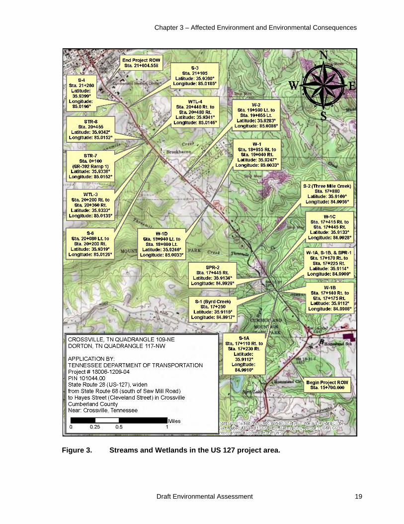
The proposed action would affect Byrd Creek, Threemile Creek, Onemile Creek, small unnamed tributaries to these streams, and springs (Figure 3). These streams are tributaries to Daddys Creek, the Obed River, and the Emory River. Additional characteristics of the streams include the following, as determined in 2006, 2009, and 2014 field surveys.
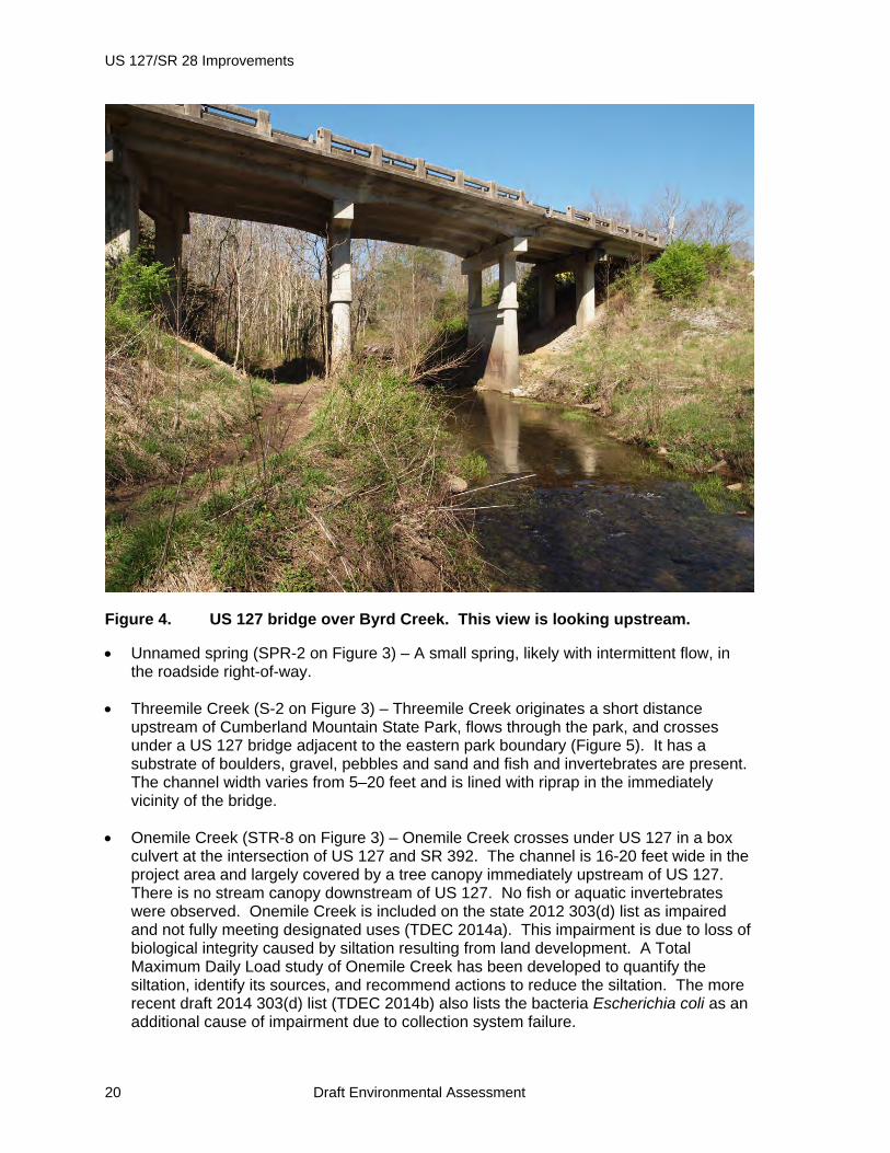
Byrd Creek (S-1 on Figure 3) – This perennial stream originates several miles upstream of Cumberland Mountain State Park and flows through the park, where it is impounded to form Byrd Lake. Downstream of the Byrd Lake dam and adjacent to the eastern park boundary, it flows under the US 127 bridge (Figure 4). The stream channel in the vicinity of US 127 is 6–25 feet wide and has a substrate of sand, gravel, and boulders. Riffles occur a short distance upstream and downstream of the bridge and the segment under the bridge is a pool. Invertebrates and fish are present, and aquatic plant beds occur immediately downstream of the bridge. Due to highway maintenance activities, tree and brush clearing under an adjacent power line, and off-road vehicle traffic, the tree canopy covers about 5 percent of the stream in the immediate vicinity of the US 127 bridge. Byrd Creek is included on the state 303(d) list as impaired for one or more designated uses due to low dissolved oxygen caused by upstream impoundment (TDEC 2014a).
Unnamed tributaries to Byrd Creek and spring (S-1A, S-1B, SPR-1 on Figure 3) – These intermittent streams and the outflow from the small spring intersect with Byrd Creek a short distance downstream of the US 127 bridge. The stream channel widths are 1–4 feet and the substrates are boulders, gravel, pebbles, and sand. The affected portions are predominantly riffles and runs with a largely open tree canopy due to powerline clearing and off-road vehicle traffic. No fish or invertebrates were observed.
Chapter 3 – Affected Environment and Environmental Consequences
Draft Environmental Assessment 19
Figure 3. Streams and Wetlands in the US 127 project area.
US 127/SR 28 Improvements
20 Draft Environmental Assessment
Figure 4. US 127 bridge over Byrd Creek. This view is looking upstream.
Unnamed spring (SPR-2 on Figure 3) – A small spring, likely with intermittent flow, in the roadside right-of-way.
Threemile Creek (S-2 on Figure 3) – Threemile Creek originates a short distance upstream of Cumberland Mountain State Park, flows through the park, and crosses under a US 127 bridge adjacent to the eastern park boundary (Figure 5). It has a substrate of boulders, gravel, pebbles and sand and fish and invertebrates are present. The channel width varies from 5–20 feet and is lined with riprap in the immediately vicinity of the bridge.
Onemile Creek (STR-8 on Figure 3) – Onemile Creek crosses under US 127 in a box culvert at the intersection of US 127 and SR 392. The channel is 16-20 feet wide in the project area and largely covered by a tree canopy immediately upstream of US 127. There is no stream canopy downstream of US 127. No fish or aquatic invertebrates were observed. Onemile Creek is included on the state 2012 303(d) list as impaired and not fully meeting designated uses (TDEC 2014a). This impairment is due to loss of biological integrity caused by siltation resulting from land development. A Total Maximum Daily Load study of Onemile Creek has been developed to quantify the siltation, identify its sources, and recommend actions to reduce the siltation. The more recent draft 2014 303(d) list (TDEC 2014b) also lists the bacteria Escherichia coli as an additional cause of impairment due to collection system failure.

Chapter 3 – Affected Environment and Environmental Consequences
Draft Environmental Assessment 21
Figure 5. US 127 bridge over Threemile Creek. This view is looking upstream.
Unnamed tributary to Onemile Creek (S-6 on Figure 3) – This small intermittent stream crosses under US 127 in a culvert. It has a channel width of 1–8 feet and depth of 1–3 feet. The substrate is gravel, mud, and sand, and no fish or aquatic invertebrates were observed. Scattered trees occur along the stream upstream of US 127.
Unnamed tributary to Onemile Creek (S-3 on Figure 3 – This small intermittent stream crosses under US 126 in a culvert. It has a channel width of 3–5 feet and depth of 1–2 feet. The substrate is boulders, gravel, and sand, and no fish or aquatic invertebrates were observed. It has a partial tree canopy.
Unnamed tributary to Onemile Creek (S-4 on Figure 3) – This small intermittent stream crosses under US 127 in a culvert. Upstream of US 127, it has a channel width of 1–2 feet and depth of 1–5 inches. Downstream, the width is 5 feet and depth 6 inches. The substrate is sand, gravel, and silt, and fish and aquatic insects are present. The upstream and downstream reaches both have a tree canopy.
Twenty-four wet-weather conveyances would be affected by the proposed action. Wet-weather conveyances are defined as watercourses that flow only in direct response to local precipitation and normally lack sufficient water to support fish or other aquatic organisms dependent on flowing water.

US 127/SR 28 Improvements
22 Draft Environmental Assessment
Environmental Consequences
Under the No-Build Alternative, there would be no project-related changes to the existing environmental conditions and therefore no direct, indirect, or cumulative impacts to streams and associated water quality and aquatic life.
Implementation of the Build Alternative would result in impacts to streams, wetlands, and associated water quality and aquatic life as a result of stream and wetland fills, stream relocations, replacement of bridges with culverts, culvert extensions, and relocations of buried utility pipelines. Impacts during construction would also result from erosion and sediment runoff into streams and wetlands.
TDOT proposes to replace the bridges over Byrd Creek and Threemile Creek concrete slab culverts because of the lower cost of the culverts. The Byrd Creek bridge would be replaced with a 196-foot long, 16-foot wide by 15-foot tall culvert. The Threemile Creek bridge would be replaced with a 192-foot long, 12-foot wide by 12-foot tall culvert. Rip-rap would be placed along the proposed culvert wingwalls upstream and downstream of the culvert.
A 437-foot section of the S-1A tributary to Byrd Creek would be relocated to a constructed channel lined with natural stone with one row of trees and one row of shrubs planted on each side of the stream. This relocation would result in a 54-foot loss of stream channel. An 89-foot section of the S-1B tributary to Byrd Creek and the associated SPR-1 spring run would be eliminated. The culverts for the S-3 and S-4 tributaries to One Mile Creek would be replaced with no net loss of stream length. The existing box culvert at Onemile Creek would be extended by 19 feet.
TDOT would implement construction-related best management practices (BMPs) to minimize water quality and aquatic resource impacts resulting from road construction activities. TDOT would also comply with applicable environmental laws and regulations (e.g., TDEC Storm Water Construction Permit) and the General and Standard Conditions marked as applicable in the TVA Section 26a permit. Proper implementation by TDOT of the BMPs and of the mitigation measures prescribed in the USCOE and TDEC permits is expected to result in only minor and temporary direct, indirect, and cumulative impacts to surface waters.
TDOT proposes a combination of onsite mitigation and payment of mitigation fees to mitigate the impacts of stream encapsulation and stream length loss. A total of 691 feet of stream channel would be rebuilt in a manner to mimic the original channel characteristics such as size, shape, and substrate as closely as possible. A row of native trees and shrubs would be planted on each streambank. TDOT determined that additional onsite mitigation was not practical due to limited space and proposes to mitigate for 340 feet of stream loss and encapsulation by paying $81,600 to the Tennessee Wildlife Resources Foundation for the In-Lieu Fee Stream Mitigation Program. With the implementation of the onsite mitigation and the payment to the In Lieu Fee Stream Mitigation Program, direct, indirect, and cumulative impacts to aquatic life and habitats would be insignificant.
3.3 Wetlands
Affected Environment

Chapter 3 – Affected Environment and Environmental Consequences
Draft Environmental Assessment 23
Wetlands are areas that are inundated or saturated with water that support vegetation adapted to saturated soil conditions. Wetlands typically include swamps, marshes, bogs, and similar areas. To be classified as a wetland, an area must have vegetation adapted to saturated conditions, have hydric soil types, and/or be saturated or covered with water at some time during the growing season of each year (Cowardin et al. 1979). The CWA prohibits the discharge of dredge or fill material in waters of the United States (including wetlands) without a Section 404 permit.
Executive Order (EO) 11990 - Protection of Wetlands requires federal agencies to avoid new construction in wetlands, unless there is no practicable alternative, and where wetlands cannot be avoided, the proposed action must include all practicable measures to minimize harm to the wetlands.
TDOT conducted a wetland assessment of the project area to determine the types and locations of wetland present within the project footprint. Wetland determinations were performed according to the USACE standards which require documentation of hydrophytic (i.e., wet-site) vegetation, hydric soil, and wetland hydrology (Environmental Laboratory 1987; Reed 1997; U.S. Department of Defense and USEPA 2003). TDOT identified four small wetlands with a total area of 0.409 acre that would be affected by the proposed action. One of these wetlands, with an area of 0.088 acre, is classified as an isolated wetland and not subject to Section 404 permitting requirements. The remaining wetland areas are subject to Section 404 permitting requirements. Following are brief descriptions of the wetlands which are identified in Figure 3.
Wetlands W-1A and W-1B – These are small herbaceous and scrub-shrub wetlands associated with the S-1A and S-1B streams and the SPR-1 spring. They have been disturbed by excavation, vehicle traffic, and periodic right-of-way mowing.
Wetland W-1C – This 0.03-acre scrub shrub wetland is located in the highway right-of-way and periodically mowed. It receives flow from two wet-weather conveyances and surface runoff from US 127.
Wetlands W-1 and W-1D – These two emergent wetlands are divided by US 127 and connected by a drainage pipe. They have been heavily disturbed by excavation, fill, and repeated mowing, mostly as a result of the development of the adjacent Homestead Place subdivision. Vegetation includes grasses, sedges and spikerush.
Wetland W-2 – This 0.5-acre forested wetland is vegetated with silver maple, willow, black gum, sedge, and cattail.
Wetland WTL-3 – This 0.5-acre shrub/forested wetland drains to Onemile Creek. Portions have been mowed to maintain a utility right-of-way. Plant species present include red maple, willow, silky dogwood, cattail and rushes.
Wetland WTL-4 - This 0.1-acre emergent/shrub wetland drains to Onemile Creek. It is a remnant of a larger wetland that was filled by the construction of the US 127 - SR 392 intersection. Plant species present include red maple, willow, silky dogwood, and rushes. It is periodically mowed to maintain a utility right-of-way.
Environmental Consequences

US 127/SR 28 Improvements
24 Draft Environmental Assessment
Under the No-Build Alternative, there would be no project-related disturbance to wetlands and therefore, there would be no direct, indirect, or cumulative impacts to wetland resources.
Implementation of the Build Alternative would result in permanent impacts from the clearing and filling of a total of 0.253 acre of wetlands (0.045 acre of W-1A, 0.03 acre of W-1B, 0.025 acre of W-1C, 0.001 acre of W-1D, 0.075 acre of W-1, 0.043 acre of W-2, 0.012 acre of WTL-3, and 0.022 acre of WTL-4). The impacts to these wetlands are unavoidable because the proposed action involves making improvements to the existing US 127 roadway. Project alternatives involving highway construction along new alignments were considered early in the planning process and determined to not be feasible because of overall greater level of impacts and greatly increased costs. Thus, there is no practicable alternative to avoiding impacts to wetlands.
TDOT proposes to mitigate the impacts resulting from the wetland fills by debiting, at a 4:1 mitigation ratio, 1.01 acre of available credit at the Coffee County Wetland Mitigation Bank. Potential indirect impacts to wetland areas adjacent to the construction area would be minimized through the use of construction-related BMPs to reduce runoff and sedimentation.
Analysis of cumulative effects to wetlands takes into account wetland loss and conversion at a landscape scale. In this case, wetland loss would be compensated for through the debiting of wetland credits at an approved wetland mitigation bank. The result would be no net or cumulative loss of wetland area or wetland functions across the region. With implementation of the proposed measures, direct, indirect, and cumulative impacts to wetlands would be minor.
3.4 Floodplains
Affected Environment
Floodplains are low-lying areas, typically near rivers and streams, which are subject to periodic flooding during heavy rains and/or long periods of wet weather. Floodplains provide important functions including storage of flood waters, wetland and wildlife habitat, and improved water quality. The 100-year floodplain is the area subject to a 1 percent chance of flooding in any given year.
Executive Order 11988 (Floodplain Management) directs TVA and other federal agencies to take actions to reduce the risk of flood loss, to minimize the impacts of floods on human safety, and to preserve the natural and beneficial values served by floodplains. The EO requires that federal agencies avoid development in the 100-year floodplain unless there is no practicable alternative.
The Federal Emergency Management Agency (FEMA) publishes Flood Insurance Maps that identify areas at risk from flooding. These maps for Cumberland County and Crossville (maps 47035C0309D, 47035C0317D, and 47035C0340D) show 100-year floodplains along One Mile Creek near where it is crossed by US 127 at the intersection with SR 392. The US 127 travel lanes and shoulders are elevated above the 100-year floodplain. No FEMA-designated floodways occur in the project area.

Chapter 3 – Affected Environment and Environmental Consequences
Draft Environmental Assessment 25
Environmental Consequences
Under the No-Build Alternative, there would be no project-related impacts on floodplains. Under the Build Alternative, impacts to floodplains and flooding would be minimal. The proposed culverts and other such obstructions in streams have been designed in a manner that would not cause any increase in flood hazard from a change in flood elevations or in flow-carrying capacity of affected streams. Consistent with EO 11998, TVA considers the culverts and other such obstructions in streams to be repetitive actions in the floodplain. The proposed action would comply with the National Flood Insurance Program, guidelines for implementing EO 11988, and Federal Highway Administration guideline 23 CFR 650A.
3.5 Vegetation and Wildlife
Affected Environment
The project area is located in the Cumberland Plateau ecoregion (Griffith et al. 1998). This ecoregion is underlain by Pennsylvanian-age rock and generally has acidic soils with low fertility. Most of the ecoregion is forested, and the dominant forest types are oak-hickory and oak-pine. Approximately 75 percent of Cumberland County is forested, and the dominant forest types are, in descending order, oak-hickory, loblolly-shortleaf pine, oak-pine, and white pine (U.S. Forest Service Forest Inventory and Analysis data). Forest area has remained relatively constant over the last decade.
The major vegetation types within the immediate project area are mowed lawns and roadside rights-of-ways (ROWs), woodlands, and brushy utility ROWs. The wooded areas consist of both isolated patches of trees along the roadside and the edges of more extensive tracts extending to the east or west. Tree species present include red maple, yellow poplar, white pine, Virginia pine, white oak, southern red oak, black locust, and flowering dogwood. Most trees are in the 4-10” diameter range. Some of the wooded areas have a dense understory of invasive shrubs, including privet, bush honeysuckle, and multiflora rose. No uncommon or rare plant communities are present.
Wildlife populations in the immediate project area are dominated by species inhabiting edge and early successional habitats. Typical species in the area include white-tailed deer, raccoon, eastern cottontail, American crow, blue jay, tufted titmouse, Carolina wren, American robin, blue-gray gnatcatcher, northern cardinal, and song sparrow.
The bridge over Byrd Creek (Figure 4), and, to a lesser degree the bridge over Threemile Creek (Figure 5), serve as wildlife crossings under US 127, providing some connectivity for species moving between forested State Park lands west of US 127 and woodlands west of US 127. Based on observations of animal tracks under the Byrd Creek bridge, white-tailed deer and raccoons likely make greatest use of the wildlife crossings.
Environmental Consequences
Under the No-Build Alternative, no project-related impacts to vegetation or wildlife would occur. Under the Build Alternative, there would be impacts to vegetation and wildlife due to the highway construction activities. Several acres of early successional habitats and marginal woodlands would be eliminated and replaced by the highway or regularly mowed ROWs. Forest area in Cumberland County remained relatively constant from 1989 through 2003, at about 321.000 acres, and increased to about 328,000 acres between 2003 and 2012. The loss of forest due to the proposed action would have little direct or cumulative
US 127/SR 28 Improvements
26 Draft Environmental Assessment
effect on the overall forest area in Cumberland County. Similarly, due to the configuration of the forest affected by the proposed action, there would be minimal impacts on those species of plants and animals, such as some Neotropical migratory birds, which require extensive contiguous tracts of forest for survival. The plant and animal species present in the immediate project area are common and widespread and the effects on them would be insignificant. The replacement of the bridges over Byrd Creek and Threemile Creek with much longer concrete slab culverts would eliminate much of their utility for wildlife crossing. The affected species are generally common in the area and this is unlikely to have significant impacts on area wildlife populations.
3.6 Endangered and Threatened Species
Affected Environment
Endangered species are those determined to be in danger of extinction throughout all or a significant portion of their range. Threatened species are those determined to be likely to become endangered within the foreseeable future. The Endangered Species Act (ESA) requires federal agencies to conserve endangered and threatened species listed under the ESA. In addition, Section 7 of the ESA requires federal agencies to consult with the U.S. Fish and Wildlife Service (USFWS) when their proposed actions may affect endangered or threatened species or their critical habitats. The state of Tennessee also provides legal protection for additional species considered threatened, endangered, or in need of management within the state that are not listed under the ESA.
Information on endangered and threatened species potentially occurring in the project area was provided by TDOT in 2009. Databases of listed species maintained by the Tennessee Department of Environment and Conservation (TDEC) Natural Heritage Program and TVA were also queried in 2014 for more recent information on the presence of listed species. With the exception of the Indiana and northern long-eared bats (discussed below), no differences were noted between the 2009 data and 2014 data. Field inspections of the project area were conducted by TDOT biologists on several occasions between 2002 and 2014 and by a TVA biologist in April 2014.
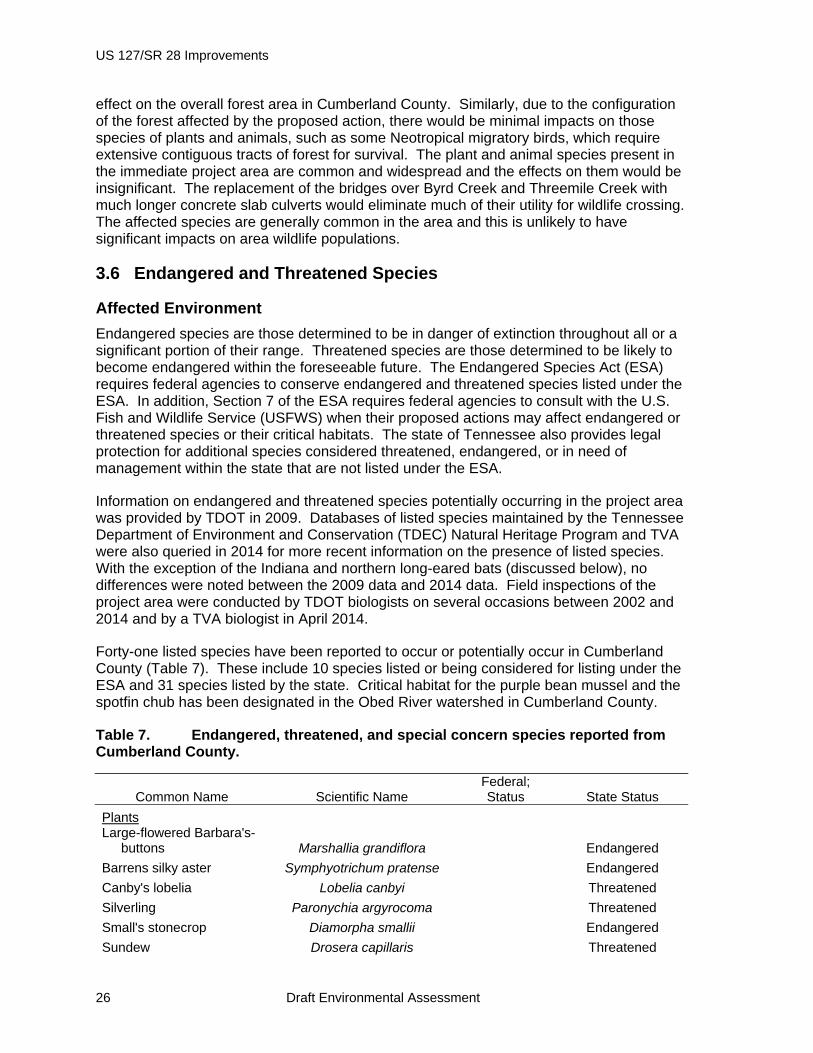
Forty-one listed species have been reported to occur or potentially occur in Cumberland County (Table 7). These include 10 species listed or being considered for listing under the ESA and 31 species listed by the state. Critical habitat for the purple bean mussel and the spotfin chub has been designated in the Obed River watershed in Cumberland County.
Table 7. Endangered, threatened, and special concern species reported from Cumberland County.
Common Name Scientific Name Federal; Status State Status
Plants Large-flowered Barbara's-
buttons Marshallia grandiflora Endangered
Barrens silky aster Symphyotrichum pratense Endangered
Canby's lobelia Lobelia canbyi Threatened
Silverling Paronychia argyrocoma Threatened
Small's stonecrop Diamorpha smallii Endangered
Sundew Drosera capillaris Threatened

Chapter 3 – Affected Environment and Environmental Consequences
Draft Environmental Assessment 27
Common Name Scientific Name Federal; Status State Status
Cumberland rosemary Conradina verticillata Threatened Threatened
Zigzag bladderwort Utricularia subulata Threatened
Roundleaf serviceberry Amelanchier sanguinea Threatened
Green pitcher plant* Sarracenia oreophila Endangered
Virginia spiraea Spiraea virginiana Threatened Endangered
Buxbaum's sedge Carex buxbaumii Endangered
Tawny cotton-grass Eriophorum virginicum Endangered
Canada lily Lilium canadense Threatened
Wood lily Lilium philadelphicum Endangered
White fringless orchid Platanthera integrilabia Candidate for
Listing Endangered
Rose pogonia Pogonia ophioglossoides Endangered Yellow nodding ladies'-
tresses Spiranthes ochroleuca Endangered
Sandreed grass Calamovilfa arcuata Threatened
Large-leaf pondweed Potamogeton amplifolius Threatened
Tennessee pondweed Potamogeton tennesseensis Threatened
Animals
A crayfish Cambarus pristinus Endangered
Purple bean mussel Villosa perpurpurea Endangered Endangered
Cumberland bean mussel Villosa trabalis Endangered Endangered
Spotfin chub Erimonax monachus Endangered Endangered
Tennessee dace Phoxinus tennesseensis In need of mgt
Tangerine darter Percina aurantiaca In need of mgt
Hellbender Cryptobranchus
alleganiensis In need of mgt Black Mountain
salamander Desmognathus welteri In need of mgt
Four-toed salamander Hemidactylium scutatum In need of mgt Eastern slender glass
lizard Ophisaurus attenuatus
longicaudus In need of mgt
Northern pine snake Pituophis melanoleucus
melanoleucus Threatened Red-cockaded
woodpecker* Picoides borealis Endangered Endangered
Golden-winged warbler Vermivora chrysoptera In need of mgt
Cerulean warbler Dendroica caerulea In need of mgt
Bachman's sparrow Peucaea aestivalis Endangered
Allegheny woodrat Neotoma magister In need of mgt
Smoky shrew Sorex fumeus In need of mgt
Southeastern shrew Sorex longirostris In need of mgt
Eastern big-eared bat Corynorhinus rafinesquii In need of mgt
Indiana bat Myotis sodalis Endangered Endangered
Northern Long-eared Bat Myotis septentrionalis Proposed
Endangered

US 127/SR 28 Improvements
28 Draft Environmental Assessment
*Extirpated from state
During field inspections of the project area, none of the listed plants or habitats suitable for the listed plants were observed. The federally listed mussels and the spotfin chub occur over 25 miles downstream of the project area and suitable habitat for these species is not present in the project area. The state-listed fish and crayfish could occur closer to the project, although habitat quality in the immediate vicinity of the project area is marginal. Suitable habitat for the hellbender, Black Mountain and four-toed salamanders, eastern slender glass lizard, northern pine snake, the listed birds, and the state-listed mammals does not occur in the project area.
The entire state of Tennessee falls within the summer range of the Indiana bat, and all suitable woodlands throughout the state are considered potential Indiana bat habitat by the USFWS (2012). Although this species has not been documented as occurring in Cumberland County, records for Indiana bats are known from Fentress and White counties within 20 miles of the project site. Indiana bats roost together in caves in large numbers during winter months, throughout central and mid-southern U.S. In the summer they migrate to woodlands throughout the eastern half of the U.S. Their range during summer months extends from northern New York to northern Alabama and Mississippi. In these woodlands, males and groups of breeding females roost under exfoliating bark found on snags or live trees.
The northern long-eared bat is a small bat associated with mature, interior forest habitats. This species is susceptible to white-nose syndrome, and the USFWS recently proposed to list the northern long-eared bat as endangered. Currently northern long-eared bat is thought to occupy habitat similar to Indiana bat. Northern long-eared bats utilize caves and mines during winter months, and roost in live and dead trees with exfoliating bark, crevices and cracks during summer months. No caves or mine shafts occur in the immediate vicinity of the project area.
TDOT biologists conducted an Indiana bat habitat suitability assessment in 2010 (Kathman 2010). The majority of the area that would be disturbed for widening US 127 and SR 68 is already cleared of trees. Potentially suitable summer roost habitat for Indiana bats, consisting of trees greater than 6” diameter, occurs in four areas. In 2014, following the 2013 proposal to list the northern long-eared bat as endangered, TDOT biologists revisited the project area. TDOT determined that no changes to habitat suitability for Indiana bat had occurred in the interim between the 2010 assessment and 2014, and that these areas were also potentially suitable habitat for the northern long-eared bat.
Environmental Consequences
Under the No-Build Alternative, no project-related impacts to federally or state-listed endangered and threatened species, designated critical habitat, and species listed as in need of management would occur.
Under the Build Alternative, construction activities with the potential to affect federally and state-listed species include the removal of trees, placement of fill, replacement of bridges with box culverts, extension of existing culverts, and stream relocations. None of the listed aquatic animals are known to occur in the immediate vicinity of the project area. TDOT would use appropriate BMPs during construction and maintenance of the widened US 127 / SR 68 as specified by applicable regulations and permits to minimize impacts to water
Chapter 3 – Affected Environment and Environmental Consequences
Draft Environmental Assessment 29
quality and stream flows. With implementation of these measures, there would be no direct, indirect, or cumulative impacts to listed aquatic species and no adverse modification of designated critical habitats. No federally or state-listed plants are known or likely to occur in the project area and there would be no impacts on these species. Similarly, no state-listed amphibians, reptiles, birds, or mammals would be affected.
TDOT initially consulted with the USFWS on potential effects to species listed under the ESA in 2002. In a letter dated October 2, 2002, the USFWS stated that their records did not indicate the presence of listed species in the project area (Appendix A). Based on the results of subsequent field surveys, it was determined that a small amount of potentially suitable summer roost habitat for Indiana and northern long-eared bats would be affected by the proposed action. Due to the limited area and quality of this habitat, TDOT determined that the proposed action may affect the Indiana bat, and that the effects would likely not be adverse. In a letter dated September 15, 2010 (Appendix A) the USFWS concurred with this determination for the Indiana bat. TVA concurs with this determination. TVA and TDOT have also determined that effects on the northern long-eared bat would not be adverse. TVA has requested concurrence from USFWS on the determination of effects on the northern long-eared bat.
3.7 Parks, Natural Areas, and Recreation
Affected Environment
Cumberland Mountain State Park (CSMP) is located within the project area, adjacent to the west side of US 127. The development of CSMP began in 1934 as an integral component of the Cumberland Homesteads project to provide a recreation area for Homesteads residents. The Farm Security Administration transferred the Cumberland Homesteads Park to the State of Tennessee in 1938, and in 1940 it officially opened as Cumberland Mountain State Park. CSMP has an area of 1,720 acres. Amenities include cabins, a 140-space campground accommodating tents and recreational vehicles, a picnic area, 15 miles of hiking trails, ball fields, a swimming pool, a restaurant, a recreation hall, meeting rooms, and a golf course. Byrd Creek is impounded within the park to create the 35-acre Byrd Lake, where fishing and boat rentals are available (Tennessee State Parks 2014).
The main entrance to CSMP is on US 127 0.75 miles southwest of the junction of US 127 and SR 68. This park entrance is 0.3 miles southwest of the proposed highway construction area. The CSMP campground, at its closest point, is about 600 feet from the southern limit of proposed construction on US 127. CSMP property also adjoins the US 127 ROW in two locations. An approximately 1,400 foot segment of park property adjoins US 127 in the vicinity of Byrd Creek bridge and an approximately 1,200-foot segment of park property adjoins US 127 a short distance northwest of the Threemile Creek bridge.
Two CMSP hiking trails are close to US 127. The 2.1 mile Byrd Creek Trail runs roughly parallel to the banks of Byrd Creek to a trailhead accessible from Byrds Creek Lane (also known as Old Homestead Highway), about 200 feet from the US 127 bridge over Byrd Creek. The 6-mile Overnight Trail connects to Byrd Creek Trail at this trailhead; an 0.9-mile segment of the Overnight Trail extends north-west of this trail junction roughly parallel to and within about 1,500 feet of US 127. Except at the trailhead on Byrds Creek Lane, US 127 is not visible from the Byrd Creek Trail or the Overnight Trail. Noise from traffic on US 127, particularly truck traffic, is a prominent part of the soundscape on parts of these two trails.

US 127/SR 28 Improvements
30 Draft Environmental Assessment
None of the streams in the immediate project area are designated as Wild and Scenic Rivers or listed on the National Rivers Inventory. A segment of Daddys Creek located approximately 25 stream miles downstream of the project area is within the Obed Wild and Scenic River (WSR), as are the Obed and Emory Rivers downstream of Daddys Creek. The outstandingly remarkable values of the Obed WSR include free-flowing streams, wildlife resources, and primitive character (NPS 1995).
Recreational off-road vehicle (ORV) use is common in the forested area immediately east of US 127 at the Byrd Creek bridge and along the edge of the US 127 ROW. The ORV trail network extends under the Byrd Creek bridge to the west side of US 127 (see Figure 4). There is little evidence of regular recreational use of other parts of the US 127 or SR 68 ROW.
Environmental Consequences
Under the No-Build Alternative, there would be no project-related impacts on parks, natural areas, and recreation in the project area. Under the Build Alternative, the proposed action would not encroach on CSMP property in the vicinity of Byrd Creek and access to the trailhead on Byrds Creek Lane would be maintained during and after construction. Hikers on the section of Byrd Creek Trail near this trailhead, as well as on parts of the Overnight Trail between Byrd Creek and Three Mile Creek would notice the noise produced by highway construction equipment. Hikers in these areas can currently hear intermittent noise from traffic, particularly large trucks, on US 127. Thus the Build Alternative would have no significant impact on CSMP. The replacement of the Byrd Creek bridge with a concrete box culvert would reduce or eliminate the ORV crossing under US 127. This would likely have little effect on overall ORV use in the project area.
3.8 Air Quality
Affected Environment
Cumberland County is in attainment with the National Ambient Air Quality Standards for all criteria air pollutants (USEPA 2013).
Environmental Consequences
Under the No-Build Alternative, there would be no project-related impacts to air quality. Emissions of air pollutants from vehicles in the project area would be proportional to vehicle miles travelled, although they are expected to decrease as a result of more stringent fuel mileage standards.
Under the Build Alternative, impacts to air quality would be minimal. Construction activities typical of roadway projects generate particulate matter (mostly dust) and small amounts of other pollutants. Emissions during construction activities would be temporary and limited to the immediate area surrounding the construction site. To reduce air quality impacts during construction, the construction contractor would be required to comply with all local, state, and federal regulations concerning air pollution related to construction activities. Mitigation measures normally used include applying water or suppressants during dry weather and taking other measures, such as covering loads to prevent the transport of dirt and dust from construction onto nearby roads.
Chapter 3 – Affected Environment and Environmental Consequences
Draft Environmental Assessment 31
According to TDOT and based upon the analysis of highway projects with similar meteorological conditions and traffic volumes, the carbon monoxide (CO) levels of the subject project will be well below the National Ambient Air Quality Standard (35ppm one-hour average and 9 ppm eight-hour average). Since the project will have levels below this standard and is located in a region of air quality conformity, it was determined that there will be no CO impact on the air quality of the area from the proposed project. This project qualifies as a “project with low potential MSAT [mobile source air toxics] effects” in accordance with 2009 guidance from the Federal Highway Administration.
3.9 Land Use
Affected Environment
Approximately 2.0 miles of the 3.4 mile stretch of US 127 between Cleveland Street and the US 127/SR 68 intersection at Homesteads is within the city limits of Crossville. An additional 0.7 miles of the highway close to Homesteads abuts the city limits. The remainder of US 127 and the subject stretch of SR 68 in the vicinity of Homesteads are not within or abutting the Crossville city limits but are within the designated Urban Growth Boundary for the City of Crossville. This designation, adopted in response to Section 7(b) of Tennessee Public Chapter 1101 of 1998, identifies areas adjacent to the corporate limits of a municipality where urban growth is expected over a 20-year period.
Land use along US 127 is a mix of urban development at the northern end of the project area, and suburban residential areas, commercial areas, and forest along the remainder of the project area. Part of the forested area is within Cumberland Mountain State Park. Institutional facilities include the Cumberland Medical Center complex, the Cumberland County Justice Center, a TDOT district maintenance center, the Homestead School complex, a water tower, the Homestead Museum and Tower, and at least five churches. Commercial development includes several medical offices and related health care businesses, an auto sales lot, banks, a hotel, a funeral home, and several other small businesses, both stand-alone and clustered in a few small strip malls. Social facilities include American Legion, Grange, and Veterans of Foreign Wars halls.
About half the length of the affected portions of US 127 and SR 68 is located on soils with the physical and chemical characteristics that would classify them as prime farmland (http://websoilsurvey.sc.egov.usda.gov/App/WebSoilSurvey.aspx). None of these areas are currently farmed and due to the presence of the highways and adjacent commercial and residential development, they are generally not available for farming. Little, if any, of the affected area along US 127 and SR 68 therefore qualifies as prime farmland as defined by Farmland Protection Policy Act of 1981.
Environmental Consequences
Under the No-Build Alternative, there would be no project-related impacts to land use in the project area. Under the Build Alternative, adverse impacts to land use would be minimal. About 8 acres of new ROW would be acquired. Almost all of this ROW is in narrow strips adjacent to the existing US 127 and SR 68 ROWs, and there would be no relocations of residences, businesses, or other buildings. Access to adjacent properties would be maintained during and after construction, and, for a few properties, post-construction access would be improved. Impacts to prime farmlands would be minimal.
US 127/SR 28 Improvements
32 Draft Environmental Assessment
3.10 Socioeconomics and Environmental Justice
Affected Environment
Cumberland County had an estimated population of 57,466 in 2013, a 2.5 percent increase over the 2010 population and a 22.8 percent increase over the 2000 population. The 2000-2013 population increase is much greater than the 14.2 percent in increase in the state population. The 2.5 percent increase for Cumberland County from 2010 to 2013 is similar to the 2.4 percent increase for the state during the same period (USBR 2014a, 2014b). This suggests a recent decrease in the county’s growth rate.
Population projections by the University of Tennessee Center for Business and Economic Research (UTCBER 2013) http://www.state.tn.us/tacir/population.html show an 11.1 percent population increase between 2013 and 2020, and a 23.7 percent population increase between 2013 and 2030 for Cumberland County. The projected increases for the state are 8.0 percent for 2013–2020 and 18.5 percent for 2013–2030.
Approximately 2916 people resided within 0.5 mile of the US 127/SR 68 project area in 2010 (USCB 2014a). Ninety-five percent of this population was white, slightly less than the 97.5 percent of the 2010 Cumberland County population that was white and considerably more than the 79.3 percent of the 2010 state population that was white. The median 2008–2012 per capita income of the population within 0.5 mile of the US 127/SR 68 project area was $18,423, lower than the Cumberland County per capita income of $20,584 and the state per capita income of $24,294 (USCB 2014c). The income of 16.4 percent of the Cumberland County population was below the poverty level, somewhat lower than the 17.3 percent for the state (USCB 2014c).
Environmental Consequences
Under the No-Build Alternative, there would be no project-related impacts to socioeconomics or to minority and low-income populations.
Under the Build Alternative, there would be a minor, short-term beneficial impact to the local economy during construction from increased local employment and purchasing of materials. While the relocation of some utilities would be required, service disruptions during construction would be minimized and coordinated with local service providers and end users. Although the proportions of minority and low-income populations in the project area are slightly higher than for Cumberland County, they are lower than the proportions for the state. Given this, and because there would be no project-induced relocations, no disproportionately adverse impacts to minority or low income populations would occur.
3.11 Cumulative Impacts
The Crossville area has, for several years, been one of the most rapidly developing parts of Tennessee, with the growth driven primarily by residential development. Although this growth has slowed in recent years, it is expected to continue for some time. Impacts from this development include the loss of forest and farmland and associated wildlife populations, increased sediment and nutrient runoff, and increased traffic congestion. As described above, the proposed action would result in few adverse impacts, and the adverse impacts to historic properties would be mitigated. Given the relatively limited scope of the proposed action, it is unlikely that it would result in a major increase in residential, commercial, or industrial development. Therefore, the proposed action, as defined by the Build Alternative, is not expected to result in significant cumulative impacts.
Chapter 3 – Affected Environment and Environmental Consequences
Draft Environmental Assessment 33
3.12 Unavoidable Adverse Environmental Impacts
The proposed action would result in unavoidable adverse impacts to historic properties. Although these impacts would be mitigated in compliance with Section 106 of the NHPA, there would still be the loss of some of the original components of the Cumberland Homesteads Historic District. No other unavoidable adverse environmental impacts have been identified.
3.13 Relationship of Short-Term Uses and Long-Term Productivity
Short-term impacts related to the proposed action will occur during construction operations. Some interruption of vehicular traffic flow is inevitable; however, appropriate maintenance of traffic phasing and access to adjoining roadways and driveways would be employed to minimize inconvenience. Temporary air impacts from dust and exhaust fumes, and noise associated with construction operations cannot be avoided. Every effort would be made to minimize these effects by using BMPs. Long-term benefits are anticipated to result from the proposed action, such as a decrease in traffic congestion, an improved level of service, and increased traffic safety.
3.14 Irreversible and Irretrievable Commitments of Resources
Irretrievable resources necessary for the proposed highway construction include energy (fossil fuel), concrete, aggregate, bituminous materials, and steel. None of these materials are in short supply. Implementation of the proposed project involves a commitment of a range of natural, physical, human, and fiscal resources. Land used in the construction of the proposed facility is considered an irreversible commitment during the time period that the land is used for the highway facility. However, if the facility is no longer needed, the land can be converted to another use. There would also be the irreversible loss of some of the original components of the Cumberland Homesteads Historic District, although these components have been thoroughly documented for archival purposes. The commitment of these resources is based on the concept that residents in the immediate area, state and region will benefit by the improved quality of the transportation system. These benefits would consist of improved accessibility and safety that are anticipated to outweigh the commitment of these resources.

Chapter 4 – List of Preparers
Draft Environmental Assessment 35
CHAPTER 4 – LIST OF PREPARERS
Charles P. Nicholson Education: Ph.D., Ecology and Evolutionary Biology; M.S., Wildlife
Management; B.S., Wildlife and Fisheries Science Experience: 35 years in Zoology, Endangered Species Studies, and NEPA
Compliance Involvement: NEPA Compliance and Document Preparation, Land Use,
Socioeconomics, Environmental Justice, Wildlife, Parks, Recreation and Wildlife, Water Quality and Aquatic Ecology
John T. Baxter Education: M.S. and B.S., Zoology Experience: 24 years in Protected Aquatic Species Monitoring, Habitat
Assessment, and Recovery; 16 years in Environmental Review
Involvement: Threatened and Endangered Species, Aquatic Ecology
Adam J. Dattilo Education: M.S., Forestry; B.S., Natural Resource Conservation
Management Experience: 12 years in Ecological Restoration and Plant Ecology; 8 years
in Botany Involvement: Threatened and Endangered
Britta P. Dimick Education: M.S., Botany-Wetlands Ecology Emphasis; B.A., Biology Experience: 15 years in Wetlands Assessments, Botanical Surveys,
Wetlands Regulations, and/or NEPA Compliance Involvement: Wetlands
Clinton E. Jones Education: B.S., Wildlife and Fisheries Science Experience: 22 years in Environmental Consultation and Fisheries
Management Involvement: Aquatic Ecology
Holly G. LeGrand Education: M.S., Wildlife; B.S., Biology Experience: 10 years in Biological Surveys, Natural Resource
Management, and Environmental Reviews Involvement: Threatened and Endangered Species, Wildlife
Roger A. Milstead, P.E. Education: B.S., Civil Engineering Experience: 38 years in Floodplain and Environmental Evaluations Involvement: Floodplains

US 127/SR 28 Improvements
36 Draft Environmental Assessment
Marianne M. Shuler Education: B.A., Religion/Middle Eastern Archaeology Experience: 10 years in Archaeology and Cultural Resource Management Involvement: Cultural Resources
Chapter 5 – Literature Cited
Draft Environmental Assessment 37
CHAPTER 5 – LITERATURE CITED
Alexander, L. 2000. Phase I Archaeological Survey of Proposed State Route 28 (US-127) From 0.16+ km South of Saw Mill Road to Cleveland Street in Crossville, and the Proposed State Route 392 Extension, From State Route 28 South of Crossville to State Route 1 (US-70) East of Crossville, Cumberland County, Tennessee. Report submitted to the Tennessee Valley Authority, Cultural Resources, Knoxville, Tennessee.
Brookhart, G. D. 2010. Cumberland County. The Tennessee Encyclopedia of History and Culture, Version 2.0. http://tennesseeencyclopedia.net/entry.php?rec=336.
Cowardin, L.M., V. Carter, F.C. Golet, and E.T. LaRoe. 1979. Classification of Wetland and Deepwater Habitats of the United States. U. S. Fish and Wildlife Publication FWS/OBS-79/31, Washington, D.C..
Environmental Laboratory. 1987. Corps of Engineers Wetland Delineation Manual. Vicksburg, Miss.: U.S. Army Corps of Engineers Waterways Experiment Station. Technical Report Y-87-1.
Federal Highway Administration. 2009. Interim Guidance Update on Air Toxic Analysis in NEPA Documents. Available at http://www.fhwa.dot.gov/environment/airtoxic/100109guidmem.htm.
Griffith, G. E, J. M. Omernik, and S. Azevedo. 1998. Ecoregions of Tennessee. U.S. Geological Survey, Reston, Virginia, U.S. Geological Survey.
Kathman, R. D. 2010. Letter to Mr. John Griffith on Indiana Bat: October Letting. Tennessee Department of Transportation, Nashville.
National Park Service. 1995. Obed Wild and Scenic River, Tennessee, Final General Management Plan / Development Concept Plan / Environmental Impact Statement. Atlanta, GA.
Reed, P. B. 1997. Revised National List of Plant Species that Occur in Wetlands: National Summary. U.S. Fish and Wildlife Service Biological Report 88(24).
Sellers, T, A. 2005. Historical/Architectural Assessment and Documentation of Effect Report Pursuant to 36 CFR 800. Report submitted to the Tennessee Valley Authority, Cultural Resources, Knoxville, Tennessee.
Straw, E. A. 2010. Cumberland Homesteads. The Tennessee Encyclopedia of History and Culture, Version 2.0. http://tennesseeencyclopedia.net/entry.php?rec=339.
Tennessee State Parks. 2014. Cumberland Mountain State Park. http://tnstateparks.com/parks/about/cumberland-mountain; accessed March 27, 2014.
(TDEC) Tennessee Department of Environment and Conservation. 2014a. Final Version - Year 2012 303(d) List. Tennessee Department of Environment and Conservation,

US 127/SR 28 Improvements
38 Draft Environmental Assessment
Nashville. Available at http://www.tn.gov/environment/water/docs/wpc/2012-final-303d-list.pdf.
_____. 2014b. Draft Year 2014 303(d) List. Tennessee Department of Environment and Conservation, Nashville. Available at http://www.tn.gov/environment/water/docs/wpc/2014-draft-303d-list.pdf.
U.S. Census Bureau. 2014a. State & County QuickFacts, http://quickfacts.census.gov/qfd/states/47/47035.html, accessed 13 May 2014
U.S. Census Bureau. 2014b. American FactFinder – Census 2000 Summary File 1. http://factfinder2.census.gov/bkmk/table/1.0/en/DEC/00_SF1/DP1/0500000US47035, accessed 13 May 2014.
U.S. Census Bureau. 2014c. American FactFinder – Selected Economic Characteristics, 2008–2012 American Community Survey 5-Year Estimates. http://factfinder2.census.gov/bkmk/table/1.0/en/ACS/12_5YR/DP03/0500000US47035%7C0400000US47, accessed 13 May 2014.
U.S. Department of Defense and U.S. Environmental Protection Agency. 2003. Advance Notice of Proposed Rulemaking on the Clean Water Act Regulatory Definition of Waters of the United States. Federal Register, Volume 68(10), January 15, 2003.
U.S. Environmental Protection Agency. 2013. Currently Designated Nonattainment Areas for All Criteria Pollutants. http://www.epa.gov/oaqps001/greenbk/ancl.html; accessed April 28, 2014.
University of Tennessee Center for Business and Economic Research (UTCEBR). 2013. State and County Population Projections. Available at http://www.state.tn.us/tacir/population.html, accessed 13 May 2014.

Appendix A – NEPA Overview
Draft Environmental Assessment 39
Appendix A - NEPA COMPLIANCE PROCESS OVERVIEW
The National Environmental Policy Act (NEPA) requires federal agencies, including the Tennessee Valley Authority (TVA), to consider the potential environmental impacts of actions they propose to take that will impact the physical environment before making a final decision to proceed. Specifically, NEPA requires the preparation of an Environmental Impact Statement (EIS) for a major action significantly impacting the quality of the human environment. The purpose of an EIS is to assess the potential environmental impacts of the proposed action and alert the federal agency decision maker and the public to those impacts before a final decision to proceed with the action is made. Regulations or procedures guide implementation of the statute.
TVA is subject to and complies with two sets of regulations or procedures that implement NEPA. These are the regulations promulgated by the Council on Environmental Quality (CEQ) at 40 C.F.R. parts 1500-1508 and TVA’s own NEPA procedures which supplement CEQ’s regulations. TVA’s NEPA procedures were adopted through a rulemaking process with public notice and opportunity for comment. TVA initially published its final NEPA procedures in the Federal Register in 1980 and later amended them after public notice and comment and republished them in the Federal Register in 1983. 48 Fed. Reg. 19,264 (Apr. 28, 1983). CEQ approved TVA’s initial and amended procedures. Internally, TVA’s “NEPA Interface” staff currently oversees TVA’s compliance with NEPA.
CEQ’s regulations and TVA’s NEPA procedures identify three levels of NEPA review. The most detailed and time-consuming level of review is an EIS. EISs are comprehensive, detailed documents often exceeding 300 pages exclusive of appendices and typically take 12 to 36 months or longer to complete. EIS processes provide opportunities for public comment, including a minimum mandatory 45-day comment period on draft EISs. Section 5.4 of TVA’s NEPA procedures provides that certain actions “normally” require an EIS including large water resource projects, major power generating facilities, and uranium mining and milling complexes. This refers to the construction of such facilities, not their continued operation. This section also requires the preparation of an EIS for “any major action, the environmental impact of which is expected to be highly controversial.” The controversy must be about the significance of environmental impacts, must have valid scientific underpinnings, and must be substantial. What is “substantial” requires consideration of the number of people raising legitimate environmental concerns in the context of the potentially affected population and whether other expert agencies have environmental concerns.
The lowest level of NEPA review applies to those actions determined to fall within one or more of the Categorical Exclusions (CEs) identified in TVA’s NEPA procedures. Section 5.2 of the procedures identifies 28 categories of actions that were predetermined during the rulemaking process normally to not result in significant environmental impacts and to not require an EIS. Neither CEQ’s regulations nor TVA’s procedures require that CEQ applicability determinations be documented. However, it is TVA’s practice to prepare a “Categorical Exclusion Checklist” to document its CE determinations for a number of its CEs. An opportunity for public comment on a CE is not required and TVA does not provide one.
The middle level of NEPA review is an Environmental Assessment (EA). EAs are more concise, less detailed documents than EISs, and can be as short as 10 to 15 pages. However, it is TVA’s practice to provide substantial information in its EAs, and TVA’s EAs often exceed 50 pages depending on the number of resources analyzed and the complexity of analyses. Neither

US 127/SR 28 to SR 68 Improvements
40 Draft Environmental Assessment
CEQ’s regulations nor TVA’s NEPA procedures require public comment on draft EAs, but TVA normally provides a 30 day comment period. The purpose of an EA is to determine whether a proposed action that is not categorically excluded is a major action with significant impacts on the quality of the human environment. If it is, an EIS is required. If it is not, TVA concludes the EA process by issuing a Finding of No Significant Impact, allowing the TVA decision maker to decide whether to proceed with the action.
Appendix B – Regulatory Agency Correspondence
Draft Environmental Assessment 41
Appendix B – REGULATORY AGENCY CORRESPONDENCE

US 127/SR 28 to SR 68 Improvements
42 Draft Environmental Assessment

Appendix B – Regulatory Agency Correspondence
Draft Environmental Assessment 43

US 127/SR 28 to SR 68 Improvements
44 Draft Environmental Assessment
Appendix B – Regulatory Agency Correspondence
Draft Environmental Assessment 45
US 127/SR 28 to SR 68 Improvements
46 Draft Environmental Assessment
Appendix C – DRAFT MEMORANDUM OF AGREEMENT FOR IMPROVEMENTS TO STATE ROUTE 28, CUMBERLAND COUNTY,
TENNESSEE
Appendix C – Draft MOA
Draft Environmental Assessment 47
DRAFT
MEMORANDUM OF AGREEMENT
BETWEEN THE TENNESSEE VALLEY AUTHORITY THE ADVISORY COUNCIL ON HISTORIC PRESERVATION,
AND THE TENNESSEE STATE HISTORIC PRESERVATION OFFICER
FOR IMPROVEMENTS TO STATE ROUTE 28
CUMBERLAND COUNTY, TENNESSEE
WHEREAS the Tennessee Department of Transportation (TDOT) has requested a 26a permit from the Tennessee Valley Authority (TVA) under Section 26a of the TVA Act for proposed improvements to State Route (SR) 28 in Cumberland County, Tennessee (Project) (Appendix A); and WHEREAS TVA, in consultation with the Tennessee State Historic Preservation Officer (TN SHPO), has determined the area of potential effects (APE) for this Project to be the area encompassed by the 7.6 km (4.6 miles) stretch of SR 28 (U.S.127) extending from SR 68 to Hayes Street in Crossville, Tennessee, including the additional area needed for the right-of-way improvements and the areas within the nearby viewshed of the Project (Appendix B); and WHEREAS TVA has considered the “magnitude and nature of the undertaking and the degree of federal involvement” in determining the appropriate level of effort to identify historic properties within the APE for this Project (as set out in the Advisory Council on Historic Preservation’s (ACHP) Section 106 regulations, 36 CFR § 800.4(b)(1)), and therefore TVA is issuing a permit for work by TDOT on state-owned lands and no TVA lands or facilities are involved; and WHEREAS TVA is the designated lead federal agency under 36 CFR § 800.2(a)(2) for this undertaking; and WHEREAS the United States Army Corps of Engineers (CORPS) will ensure that applicable provisions of the MOA will be carried out as they pertain to any 404 permit required by TDOT, and may sign this agreement as a co-federal Signatory to meet its Section 106 responsibilities; and WHEREAS identification of archaeological resources and historic structures has been conducted within the APE (Appendix C); and WHEREAS TVA, in consultation with the TN SHPO and TDOT, has determined that the Project will not adversely affect archaeological resources listed in or eligible for the National Register of Historic Places (NRHP) (Appendix B); and WHEREAS TVA, in consultation with TN SHPO, and TDOT has determined that the Project will adversely affect the Cumberland Homesteads Historic District (CHHD), which is listed in the NRHP (Appendix B); and
US 127/SR 28 to SR 68 Improvements
48 Draft Environmental Assessment
WHEREAS TVA has determined that the triangle intersection (Triangle), located at the junction of State Route 28 and State Route 68, retains sufficient integrity and contributes to the historic setting of the CHHD; and WHEREAS The Project will result in an adverse effect to the CHHD by physical destruction and removal from its historic location. The Project will require right-of-way to be taken from within the historic district and the physical destruction of the Triangle will adversely affect the CHHD; and WHEREAS the proposed Project will not result in the demolition of any historic structures that contribute to the NRHP-listed CHHD; and WHEREAS TVA has notified the ACHP regarding the adverse effect finding pursuant to 36 CFR § 800.6(a)(1), and the ACHP has agreed to participate in consultation to seek ways to reduce or mitigate adverse effects (Appendix B); and WHEREAS TVA has enclosed the current documentation required under 36 CFR § 800.11(e) regarding this project (Appendix D); and WHEREAS in order to minimize adverse effects to CHHD, TDOT modified the Project to reduce the right-of-way take from a contributing historic property and to minimize impacts to the Cumberland Homesteads Tower; and WHEREAS in order to involve the public in the decision making process, TDOT created a Context Sensitive Solutions Team (CSST) made up of local citizens with a variety of interests in the Project. CSST concentrated on the design of the existing triangle intersection at State Route 28 (U.S. 127) and State Route 68. CSST presented several alternatives that TDOT studied and as a result, TDOT redesigned the intersection from the original T-intersection to a new triangle that mimics the original triangle while allowing safe traffic flow. These provisions developed by CSST are incorporated into the stipulations section of this MOA to help avoid, minimize, and mitigate adverse effects; and WHEREAS TDOT has considered alternatives to the proposed improvements, and evaluated these alternatives for affects to historic properties; and WHEREAS TDOT hosted one public meeting in 2004 and held six Citizens Resource Team meetings regarding the Project between 2004 and 2005 that were also open to the public; and WHEREAS TVA hosted a public meeting on the Project in February of 2011 and a consulting parties meeting in October of 2011; and WHEREAS TVA hosted an on-site meeting with representatives of the ACHP, the TN SHPO, TVA, and TDOT in April of 2013 to review the Project; and WHEREAS TVA is relying on the expertise and professional judgment of TDOT (the State’s transportation agency) and TDOT has stated in writing that the proposed project still has logical purpose and need, and that the Project is appropriate and necessary for the area, given current and projected traffic volumes; and WHEREAS TVA requested editorial changes to Figure 11 (page 43) in the Documentation of Effect Report and Figures 6 and 7 (pages 13 and 14) in Appendix E of the Documentation of
Appendix C – Draft MOA
Draft Environmental Assessment 49
Effect Report, and TDOT has provided revised figures that accurately depict the area that does not retain its historic integrity (Appendix E); and WHEREAS TVA investigated the question whether the historic Eldridge House was demolished in or after 2005 to avoid the requirements of Section 106. TVA determined, after consultation with the ACHP, that Section 110(k) of the National Historic Preservation Act (NHPA) does not apply to the Eldridge House because this property was demolished by a private party; TDOT did not have the legal power to prevent the demolition; and it occurred several years before TDOT applied for the permit from TVA (Appendix F); and WHEREAS TVA investigated the question whether the historic government garage was demolished in or after 2005 to avoid the requirements of Section 106. TVA determined, after consultation with the ACHP, that Section 110(k) of the NHPA does not apply to the government garage because the National Park Service found that it did not retain sufficient integrity to be eligible for the NRHP due to alterations and additions (Appendix G) ; and WHEREAS TVA investigated the question whether other historic or potentially historic properties were demolished in or after 2005 to avoid the requirements of Section 106. TVA determined, after consultation with the ACHP, that Section 110(k) of the NHPA does not apply to these other properties because they did not retain sufficient integrity to be eligible for the NRHP or are not historic properties due to their date of construction (Appendix G); and
WHEREAS TDOT has agreed to be an Invited Signatory to this Memorandum of Agreement (MOA) (Appendix B); and WHEREAS the National Trust for Historic Preservation, Statewide Organizing for Community eMpowerment—Cumberland County Chapter, Cumberland Homesteads Tower Association, the City of Crossville, the Sierra Club, Dr. Calvin Dickinson, and Dr. Michael Birdwell have participated in the consultation and have been invited to concur with this MOA document (Appendix B); and WHEREAS the Eastern Band of Cherokee Indians, Cherokee Nation, United Keetoowah Band of Cherokee Indians in Oklahoma, Muscogee (Creek) Nation of Oklahoma, Alabama-Quassarte Tribal Town, Kialegee Tribal Town, Eastern Shawnee Tribe of Oklahoma, and the Shawnee Tribe were consulted regarding this Project (Appendix B); and WHEREAS the following stipulations to reduce and mitigate adverse effects were proposed by the consulting parties and the public, and TVA, the ACHP, and the TN SHPO, find the stipulations to be appropriate for the Project. NOW, THEREFORE, TVA, ACHP, TDOT, CORPS, and the TN SHPO agree that the Project shall be implemented in accordance with the following stipulations to satisfy TVA’s and the CORPS’ responsibilities under Section 106 of the NHPA. TVA’s Federal Preservation Officer, or the designee thereof, shall act for TVA in all matters concerning the administration of this agreement.

US 127/SR 28 to SR 68 Improvements
50 Draft Environmental Assessment
STIPULATIONS TVA will ensure that the following measures are carried out by TDOT for the alternative approved by TVA: I. Measures to reduce and mitigate adverse effects on the Cumberland Homesteads Historic District. Final decisions on the details of each item below to be made by TVA after consultation with TDOT, the SHPO, and the Consulting Parties.
Signage: TDOT will provide sufficient funds to the City of Crossville to install a CHHD sign at the entrance of the District in an appropriate location along US 127/SR28 similar to the one proposed at the Triangle (Appendix H). The City of Crossville will be responsible for maintaining the sign. Guardrails: TDOT will install weathered guard rails along the proposed State Route 28 project corridor where indicated on the construction plans (Appendix H). Sidewalks: TDOT will construct a meandering sidewalk of River Rock within the historic area. Pavement: The road will be treated with tinted asphalt at the triangle intersection to delineate the historic area (Appendix H). Cumberland Homesteads Tower Museum (CHTM): TDOT will provide sufficient funds and assist the CHTM in upgrading existing exhibits within the museum. CHTM Brochure and Website: TDOT will hire a historic preservation consultant to work with the CHTM to design brochures for visitors to the museum and historic district to enhance the public’s understanding of these historic resources. TDOT will pay to print 30,000 brochures for distribution through the tower museum. The historic preservation consultant will also work with the CHTM to update and/or revise the existing Cumberland Homesteads Tower Association website. CHTM Landscaping Buffer: TDOT will work with the property owner, Cumberland County, to install a 30-foot long landscaping buffer using native plants between the CHTM and Homestead Elementary School. Cumberland County will be responsible for maintaining this buffer.
CHTM Light poles: TDOT will install decorative light poles, similar to the ones used at the Cumberland County Complex, in the planned parking at the CHTM (Appendix H).
CHTM Parking: TDOT will install a parking area in front of the tower that will be approximately 18.5 feet x 131 feet with a total of 13 parking spaces and one handicap parking space.
Appendix C – Draft MOA
Draft Environmental Assessment 51
CHTM Stone Retaining Wall: TDOT will work with the property owner, Cumberland County, to install a low, rock wall using local materials to separate the CHTM entrance from the parking area.
Triangle Landscaping: Three of the eight trees located in the existing triangle will be saved and incorporated in the proposed new triangle. TDOT will plant five, 25 gallon pot, native trees (from the oak, maple, or dogwood varieties) in the new triangle. TDOT will attempt to create a pattern similar to the tree layout in the existing triangle. TDOT will be responsible for ensuring the life of these trees for up to 5 years.
Triangle Light Poles: TDOT will install decorative light poles, similar to the ones used at the Cumberland County Complex, along the 1400-foot perimeter of the triangle (Appendix H).
Triangle Reconstruction: TDOT shall reconstruct the Triangle essentially as shown in Appendix I.
Triangle Sign: TDOT will remove, store and re-erect the CHHD sign located in the existing triangle in approximately the same location in the new triangle. TDOT will be responsible for maintaining this sign.
Triangle Wooden Posts: TDOT will replace the existing wooden posts surrounding the triangle with white, wooden break away posts (Appendix H).
II. Administrative Provisions A. Amendments: Any signatory to this Agreement may propose to the other signatories that the Agreement be amended, whereupon the signatories will consult in accordance with 36 CFR § 800.6(c)(7) to consider such an amendment. B. Dispute resolution: Should any signatory to this Agreement object to any action carried out or proposed by TVA with respect to the implementation of this Agreement, TVA shall consult with that signatory to resolve the objection. If TVA, after initiating such consultation, determines that the objection cannot be resolved, then TVA shall forward documentation relevant to the objection to the ACHP, including TVA’s proposed response to the objection. Within forty-five (45) days after receipt of all pertinent documentation, the ACHP shall exercise one of the following options:
1. Advise TVA that the ACHP concurs in TVA’s proposed final decision, whereupon TVA shall respond accordingly; 2. Provide TVA with recommendations, which TVA shall take into account in reaching a final decision regarding its response to the objection; or 3. Notify TVA that the objection will be referred to the ACHP membership for formal comment and proceed to refer the objection and comment within forty-five (45) days. The resulting comment shall be taken into account by TVA in accordance with 36 CFR § 800.7(c)(4).
US 127/SR 28 to SR 68 Improvements
52 Draft Environmental Assessment
4. Should the ACHP not exercise one of the above options within forty-five (45) days after receipt of all pertinent documentation, TVA may assume the ACHP’s concurrence in its proposed response to its objections. 5. TVA shall take into account any ACHP recommendation or comment provided in accordance with this stipulation with reference only to the subject of the objection. TVA’s responsibility to carry out all actions under this Agreement that are not the subjects of the objection shall remain unchanged.
C. Termination of MOA: Any signatory to this Agreement may terminate it by providing sixty (60) days notice to the other parties, provided that the parties will consult during the period prior to the termination to seek agreement on amendments or other actions that will avoid termination. In the event of termination of this Agreement by the TN SHPO, TVA shall comply with the provisions of 36 CFR § 800.6(c)(8). D. Duration of MOA: This Agreement will terminate if its terms are not carried out within ten (10) years from the date of the last signature on this Agreement. Prior to such time, TVA may consult with the other signatories to reconsider the terms of the Agreement and amend it in accordance with Stipulation IV. Execution of this MOA by TVA, ACHP, TDOT, CORPS, and the TN SHPO, and the subsequent implementation of its terms, evidence that TVA and the CORPS have fulfilled their obligations under Section 106 of the NHPA by taking into account the effects of the Project on historic properties.

Appendix C – Draft MOA
Draft Environmental Assessment 53
SIGNATORY: TENNESSEE VALLEY AUTHORITY By: _______________________________________ DATE: ______________ Brenda Brickhouse Senior Vice President and Federal Preservation Officer

US 127/SR 28 to SR 68 Improvements
54 Draft Environmental Assessment
SIGNATORY: ADVISORY COUNCIL ON HISTORIC PRESERVATION By: _______________________________________ DATE: ______________ John M. Fowler Executive Director

Appendix C – Draft MOA
Draft Environmental Assessment 55
SIGNATORY: TENNESSEE STATE HISTORIC PRESERVATION OFFICER By: _______________________________________ Date: _______________ E. Patrick McIntyre, Jr. State Historic Preservation Officer

US 127/SR 28 to SR 68 Improvements
56 Draft Environmental Assessment
SIGNATORY: UNITED STATES ARMY CORPS OF ENGINEERS By: _______________________________________ Date: _______________ Lieutenant Colonel John L. Hudson District Engineer

Appendix C – Draft MOA
Draft Environmental Assessment 57
INVITED SIGNATORY: TENNESSEE DEPARTMENT OF TRANSPORTATION By: _______________________________________ Date: _______________

US 127/SR 28 to SR 68 Improvements
58 Draft Environmental Assessment
CONCURRENCE BY OTHERS: NATIONAL TRUST FOR HISTORIC PRESERVATION By: _______________________________________ Date: _______________

Appendix C – Draft MOA
Draft Environmental Assessment 59
CONCURRENCE BY OTHERS: STATEWIDE ORGANIZING FOR COMMUNITY EMPOWERMENT—CUMBERLAND COUNTY CHAPTER By: _______________________________________ Date: _______________

US 127/SR 28 to SR 68 Improvements
60 Draft Environmental Assessment
CONCURRENCE BY OTHERS: CUMBERLAND HOMESTEADS TOWER ASSOCIATION By: _______________________________________ Date: _______________

Appendix C – Draft MOA
Draft Environmental Assessment 61
CONCURRENCE BY OTHERS: SIERRA CLUB By: _______________________________________ Date: _______________

US 127/SR 28 to SR 68 Improvements
62 Draft Environmental Assessment
CONCURRENCE BY OTHERS:
CITY OF CROSSVILLE By: _______________________________________ Date: _______________

Appendix C – Draft MOA
Draft Environmental Assessment 63
CONCURRENCE BY OTHERS: By: _______________________________________ Date: _______________ Dr. Michael Birdwell

US 127/SR 28 to SR 68 Improvements
64 Draft Environmental Assessment
CONCURRENCE BY OTHERS: By: _______________________________________ Date: _______________ Dr. Calvin Dickinson

Appendix C – Draft MOA
Draft Environmental Assessment 65
APPENDICES TO DRAFT MOA
The following appendices to the Draft MOA are available at http://www.tva.com/environment/reports/tnstateroute28.htm. They are also available on compact disc upon request to:
Charles P. Nicholson NEPA Compliance Tennessee Valley Authority 400 West Summit Hill Drive, WT 11D Knoxville, TN 37902-1499 E-mail: [email protected]
APPENDIX A – Project Plans & Maps
APPENDIX B – Consultation
APPENDIX C – Reports
APPENDIX D – 800.11 Documentation
APPENDIX E – 2013 Revised Figures for Documentation of Effect Report
APPENDIX F – Eldridge House Timeline
APPENDIX G – Structures Taken During ROW Acquisition Adjacent to Triangle
APPENDIX H – Mitigation
APPENDIX I – 2014 Triangle Rendering