task team 5 (ancillary measurements, tt-am) 2014 report · task team 5 (ancillary measurements,...
TRANSCRIPT

GRUAN ICM-6, Mar 10-14, 2014, Greenbelt, MD, USA
Tony Reale (NOAA)
Martine De Maziere (IASB)
Thierry Leblanc (JPL)
Task Team 5 (Ancillary Measurements, TT-AM)
2014 Report

GRUAN ICM-6, Mar 10-14, 2014, Greenbelt, MD, USA
Annual Refresher: TT-AM Terms of Reference
1. Interface with other expert teams (such as NDACC, TCCON, MWRnet, etc.)
2. Evaluate the data products (uncertainty budget etc.) and bring in missing knowledge
3. Inventory potential instruments (and interface with other GRUAN-Task Teams if needed)
4. Establish campaign rationales for the validation of data from multiple platforms
5. Establish a system for the routine collection and display of data from multiple platforms
6. Guidance on the type and amount of data and associated metadata needed to be stored
from the instruments, as needed
7. Draw conclusions on the suitability of the deployed equipment and advise accordingly
to GRUAN Task Team on Site Assessment
8. Report on all above duties to (WG-GRUAN?)
GRUAN ICM-6, Mar 10-14, 2014, Greenbelt, MD, USA
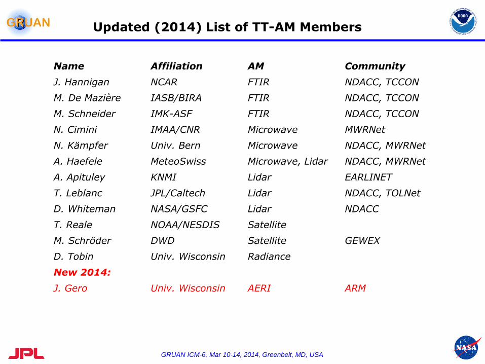
Updated (2014) List of TT-AM Members
Name Affiliation AM Community
J. Hannigan NCAR FTIR NDACC, TCCON
M. De Mazière IASB/BIRA FTIR NDACC, TCCON
M. Schneider IMK-ASF FTIR NDACC, TCCON
N. Cimini IMAA/CNR Microwave MWRNet
N. Kämpfer Univ. Bern Microwave NDACC, MWRNet
A. Haefele MeteoSwiss Microwave, Lidar NDACC, MWRNet
A. Apituley KNMI Lidar EARLINET
T. Leblanc JPL/Caltech Lidar NDACC, TOLNet
D. Whiteman NASA/GSFC Lidar NDACC
T. Reale NOAA/NESDIS Satellite
M. Schröder DWD Satellite GEWEX
D. Tobin Univ. Wisconsin Radiance
New 2014:
J. Gero Univ. Wisconsin AERI ARM
GRUAN ICM-6, Mar 10-14, 2014, Greenbelt, MD, USA
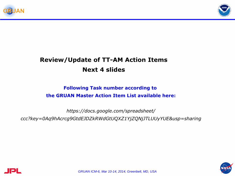
Review/Update of TT-AM Action Items
Next 4 slides
Following Task number according to
the GRUAN Master Action Item List available here:
https://docs.google.com/spreadsheet/
ccc?key=0Aq9hAcrcg9GtdEJDZkRWdGtUQXZ1YjZQNjJTLUUyYUE&usp=sharing
GRUAN ICM-6, Mar 10-14, 2014, Greenbelt, MD, USA
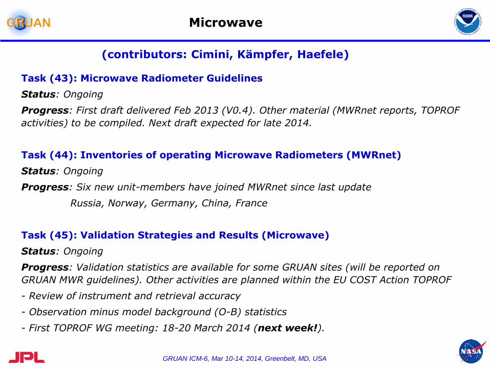
Microwave
Task (43): Microwave Radiometer Guidelines
Status: Ongoing
Progress: First draft delivered Feb 2013 (V0.4). Other material (MWRnet reports, TOPROF
activities) to be compiled. Next draft expected for late 2014.
Task (44): Inventories of operating Microwave Radiometers (MWRnet)
Status: Ongoing
Progress: Six new unit-members have joined MWRnet since last update
Russia, Norway, Germany, China, France
Task (45): Validation Strategies and Results (Microwave)
Status: Ongoing
Progress: Validation statistics are available for some GRUAN sites (will be reported on
GRUAN MWR guidelines). Other activities are planned within the EU COST Action TOPROF
- Review of instrument and retrieval accuracy
- Observation minus model background (O-B) statistics
- First TOPROF WG meeting: 18-20 March 2014 (next week!).
(contributors: Cimini, Kämpfer, Haefele)

GRUAN ICM-6, Mar 10-14, 2014, Greenbelt, MD, USA
Microwave (cont.)
COST Action ES1303
Towards operational ground based profiling with ceilometers, Doppler lidars and
microwave radiometers for improving weather forecasts
Period: Oct. 2013 – Dec. 2017.
WG 3: Microwave radiometers
Co-Chairs: Ulrich Loehnert (DE) and Nico Cimini (IT)
Objectives:
- pursue the establishment of a sustainable network of MWR
- summary of current status of “core” MWR
- assessment of procedures for calibration, operation, and maintenance
- development of harmonized QC data processing
- develop common error characteristics
TOPROF http://www.toprof.imaa.cnr.it/
GRUAN-
related
GRUAN ICM-6, Mar 10-14, 2014, Greenbelt, MD, USA
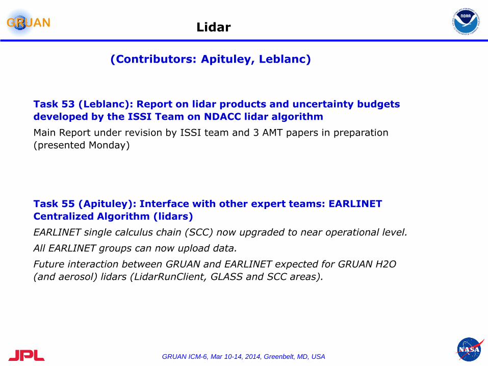
Lidar
Task 53 (Leblanc): Report on lidar products and uncertainty budgets
developed by the ISSI Team on NDACC lidar algorithm
Main Report under revision by ISSI team and 3 AMT papers in preparation
(presented Monday)
Task 55 (Apituley): Interface with other expert teams: EARLINET
Centralized Algorithm (lidars)
EARLINET single calculus chain (SCC) now upgraded to near operational level.
All EARLINET groups can now upload data.
Future interaction between GRUAN and EARLINET expected for GRUAN H2O
(and aerosol) lidars (LidarRunClient, GLASS and SCC areas).
(Contributors: Apituley, Leblanc)
GRUAN ICM-6, Mar 10-14, 2014, Greenbelt, MD, USA
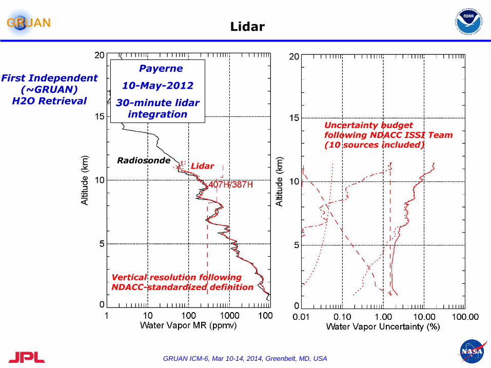
Lidar
Payerne
10-May-2012
30-minute lidar integration
Radiosonde Lidar
Uncertainty budget following NDACC ISSI Team (10 sources included)
Vertical resolution following NDACC-standardized definition
First Independent (~GRUAN)
H2O Retrieval
GRUAN ICM-6, Mar 10-14, 2014, Greenbelt, MD, USA
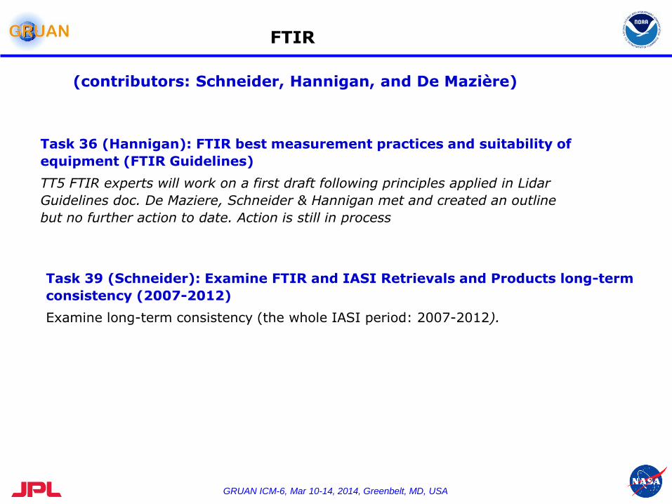
FTIR
Task 36 (Hannigan): FTIR best measurement practices and suitability of
equipment (FTIR Guidelines)
TT5 FTIR experts will work on a first draft following principles applied in Lidar
Guidelines doc. De Maziere, Schneider & Hannigan met and created an outline
but no further action to date. Action is still in process
Task 39 (Schneider): Examine FTIR and IASI Retrievals and Products long-term
consistency (2007-2012)
Examine long-term consistency (the whole IASI period: 2007-2012).
(contributors: Schneider, Hannigan, and De Mazière)

GRUAN ICM-6, Mar 10-14, 2014, Greenbelt, MD, USA
Summary
- First IRWG / NORS Error Analysis Workshop held in Boulder USA February 2012,
- Second Error Analysis Workshop associated with IRWG meeting Tsukuba Japan June 2013
- Current Activities:
- Implementation of derivative calculations (Kb) for many new possible error sources
- Ongoing testing by several groups within IRWG
- Implementation into dataset operational processing schemes
- Upload of this analysis into NDACC archive has begun
- Third workshop planned for Bremen Germany after 2014 IRWG in May
FTS Error Analysis & Budgeting

GRUAN ICM-6, Mar 10-14, 2014, Greenbelt, MD, USA
Global FTS Stations
Eureka 80 274
Ny_Alesund 79 12
Thule 77 291
Kiruna 68 20
Sodankyla 67 27
Poker_Flat 65 213
Harestua 60 11
St_Petersburg 60 30
Yekaterinburg 57 60
Tomsk 57 85
Bialystok 53 23
Bremen 53 9
Bratts_Lake 50 -104
Karlsruhe 49 8
Paris 49 2
Orleans 48 2
Garmisch 47 11
Zugspitze 47 11
Jungfraujoch 47 8
Park_Falls 46 270
Moshiri 44 142
Egbert 44 280
Rikubetsu 44 144
Toronto 44 281
Boulder 40 255
Barcroft 38 242
Lamont 37 263
Tsukuba 36 140
Table_Mtn 34 242
Kitt_Peak 32 248
Izana 28 344
Mauna_Loa 20 204
Mexico_City 19 -99
Altzomoni 19 -99
Addis_Ababa 9 39
Paramaribo 6 305
Ascension -8 -14
Darwin -12 131
Reu_Maido -21 55
Reu_St_Denis
-21 55
Wollongong -34 151
Lauder -45 170
Syowa_Station -69 40
Arrival_Heights -79 167
GRUAN ICM-6, Mar 10-14, 2014, Greenbelt, MD, USA
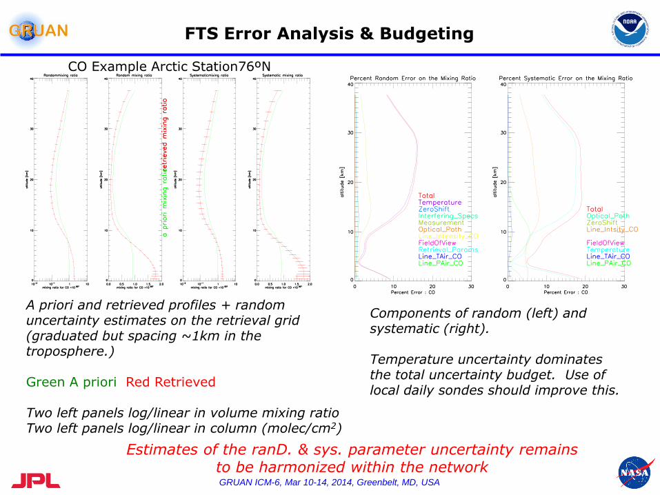
FTS Error Analysis & Budgeting
A priori and retrieved profiles + random uncertainty estimates on the retrieval grid (graduated but spacing ~1km in the troposphere.) Green A priori Red Retrieved Two left panels log/linear in volume mixing ratio Two left panels log/linear in column (molec/cm2)
CO Example Arctic Station76ºN
Components of random (left) and systematic (right). Temperature uncertainty dominates the total uncertainty budget. Use of local daily sondes should improve this.
Estimates of the ranD. & sys. parameter uncertainty remains to be harmonized within the network
27
28
29
-17 -16 -15
+ IASI-A
+ IASI-B
Izana (FTIR
+ Picarro)
Teide (Picarro)
aircraft (ISOWAT
+ flasks)
longitude [°]
latitu
de [°]
1000 2000 3000
1000
2000
3000
-300 -200 -100
-300
-200
-100
^
24
25
30
31
IAS
I H
2O
[p
pm
v]
ISOWAT H2O (x
IW) [ppmv]
H2O
^
D
IAS
I D
[0/ 0
0]
ISOWAT D (xIW
) [0/00
]
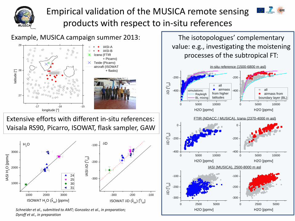
Empirical validation of the MUSICA remote sensing products with respect to in-situ references
Extensive efforts with different in-situ references: Vaisala RS90, Picarro, ISOWAT, flask sampler, GAW
Schneider et al., submitted to AMT; Gonzalez et al., in preparation; Dyroff et al., in preparation
The isotopologues’ complementary value: e.g., investigating the moistening
processes of the subtropical FT:
0 5000 10000
-400
-200
0 5000 10000
-400
-200
simulations:
Rayleigh
BL mixing
all
airmass
from higher
latitudes
D
[0/ 0
0]
H2O [ppmv]
in-situ reference (1500-6800 m asl)
all
airmass from
boundary layer (BL)
H2O [ppmv]
0 5000 10000
-400
-200
0
0 5000 10000
-400
-200
0
FTIR (NDACC / MUSICA), Izana (2370-4000 m asl)
D
[0/ 0
0]
H2O [ppmv] H2O [ppmv]
0 2500 5000
-300
-200
-100
0 2500 5000
-300
-200
-100
D
[0/ 0
0]
H2O [ppmv]
IASI (MUSICA), 2500-8000 m asl
H2O [ppmv]
Example, MUSICA campaign summer 2013:
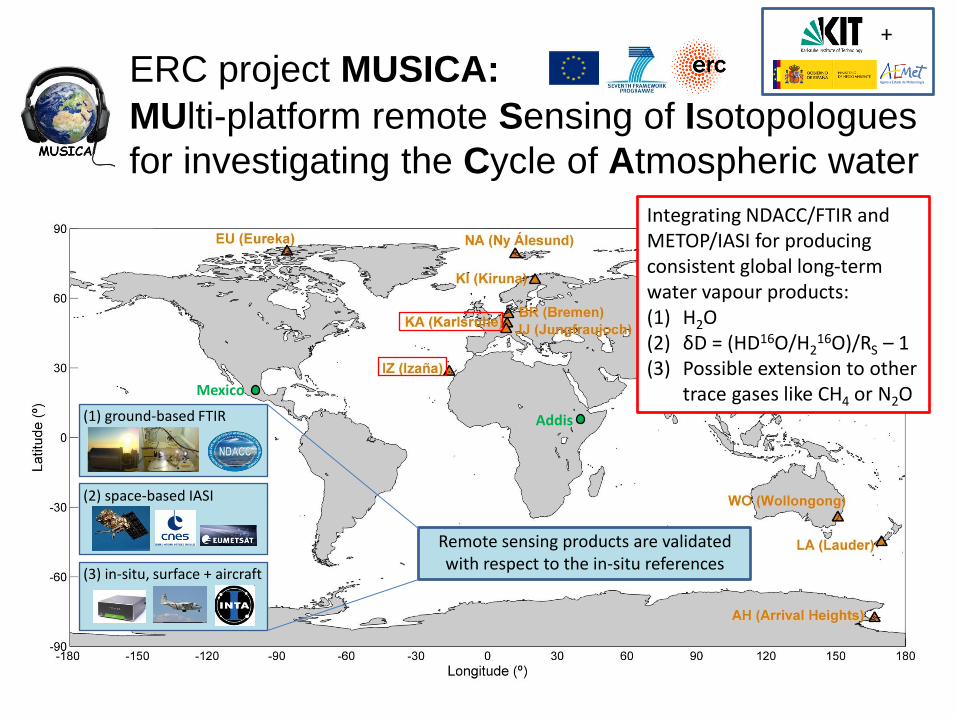
MUlti-platform remote Sensing of Isotopologues
for investigating the Cycle of Atmospheric water
ERC project MUSICA:
(1) ground-based FTIR
(2) space-based IASI
(3) in-situ, surface + aircraft
Mexico
Addis
+
Remote sensing products are validated with respect to the in-situ references
Integrating NDACC/FTIR and METOP/IASI for producing consistent global long-term water vapour products: (1) H2O (2) δD = (HD16O/H2
16O)/RS – 1 (3) Possible extension to other
trace gases like CH4 or N2O
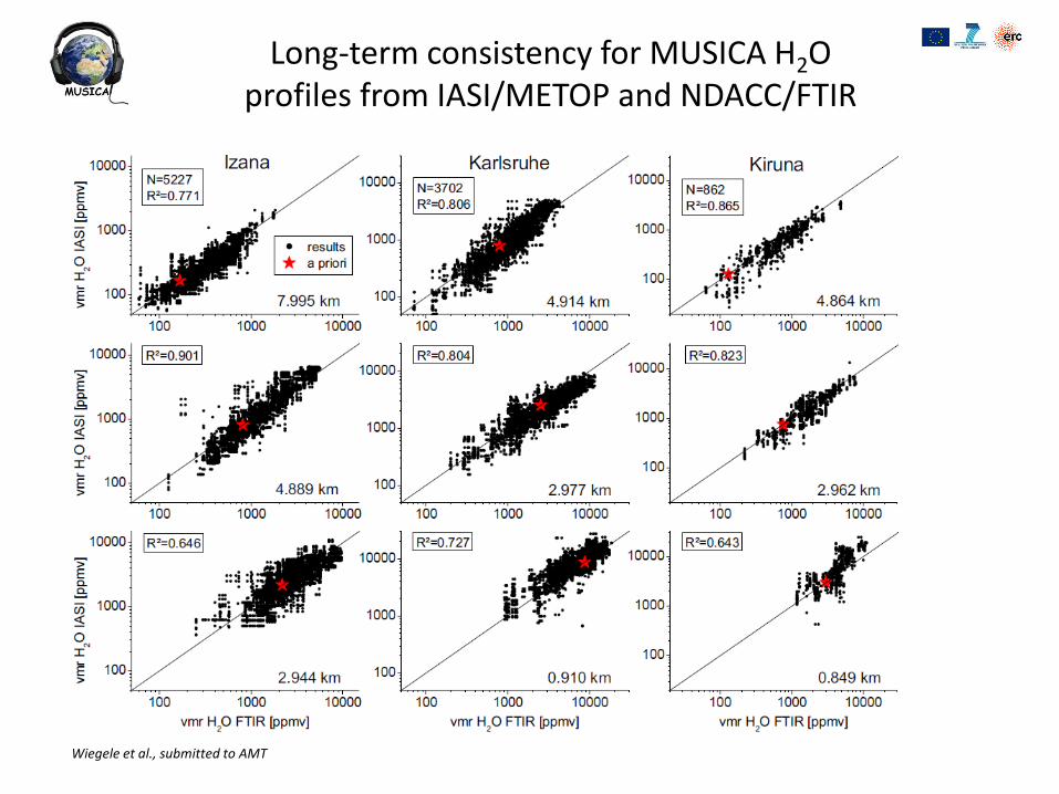
Long-term consistency for MUSICA H2O profiles from IASI/METOP and NDACC/FTIR
Wiegele et al., submitted to AMT
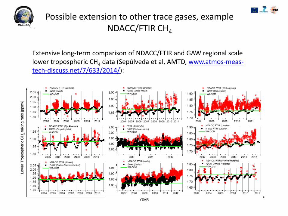
Possible extension to other trace gases, example NDACC/FTIR CH4
Extensive long-term comparison of NDACC/FTIR and GAW regional scale lower tropospheric CH4 data (Sepúlveda et al, AMTD, www.atmos-meas-tech-discuss.net/7/633/2014/):

M. De Mazière MACC II OSC, 27-30/1/2014
NORS
NORS : Demonstration Network Of ground-based Remote Sensing Observations (of NDACC) in support of the Copernicus Atmospheric Service (CAS or MACC-II at present) EU FP7 project, coordinator: M. De Mazière
• Start: Nov. 1, 2011
• Duration: 33 months, i.e., up to July 2014
• Objective:
To perform the required research and developments for optimizing the NDACC data for the purpose of supporting the quality assessments of the CAS
Research part
To develop and implement a Web-based Validation Server of the MACC-II (CAS) products using the NORS data products
Operational part
M. De Mazière MACC II OSC, 27-30/1/2014
NDACC reference data requirements
• Ensure long-term quality
Quality assurance protocols
• Network consistency
• Timely data delivery
• Data documentation
• Metadata, use guide, documented uncertainties
NORS advances the NDACC data in this direction
M. De Mazière MACC II OSC, 27-30/1/2014
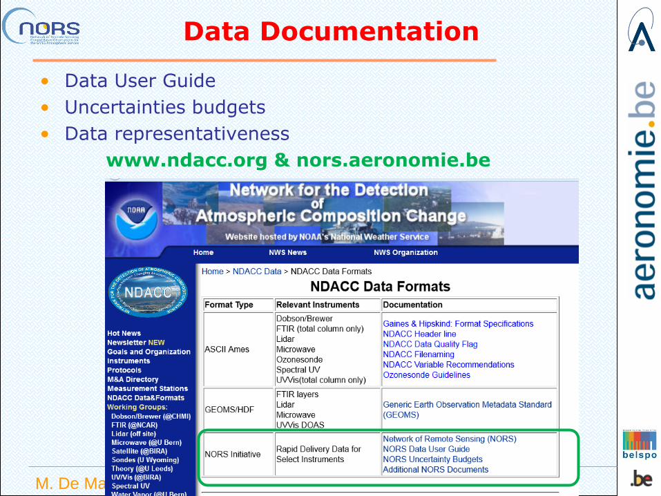
Data Documentation
• Data User Guide
• Uncertainties budgets
• Data representativeness
www.ndacc.org & nors.aeronomie.be

M. De Mazière MACC II OSC, 27-30/1/2014
Representativeness
0
1
2
3
0 10 20 30 40 50
Horizontal distance [km]
Altitude [
km
]
height_0°
height_1°
height_2°
height_3°
height_6°
MAXDOAS
Percentage of column
Latitude (°) Longitude East (°)
Altitude (km) Distance (km)
0 -20,900 55,480 0,05 0,0 20 -20,906 55,511 1,8 3,3 40 -20,912 55,546 3,8 7,0 60 -20,921 55,596 6,6 12,3 80 -20,934 55,666 10,6 19,7
Table 1. Example of a ray tracing output for an FTIR measurement of CH4 at St Denis (-20.9°S, 55.5°E),
Ile de La Reunion, on 25/1/2011 04:04 UT for a solar zenith angle of 62° and an azimuth angle of 101°
measured from N (0°) to E (90°). The Table provides the geographical location of the points along the
line of sight corresponding to a percentage of the total CH4 column.
FTIR

M. De Mazière MACC II OSC, 27-30/1/2014
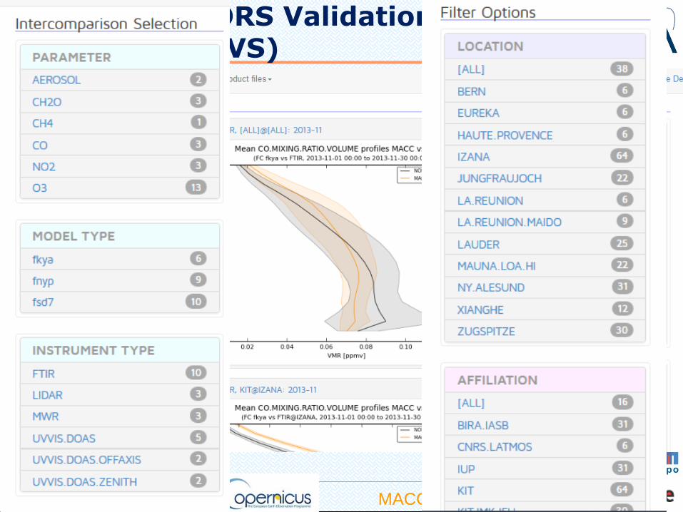
Operational Part
NORS Validation Server
http://nors-server.aeronomie.be
It takes
HDF data from the NDACC database and
& MACC-II model data from the MARS archive,
creates automatic validation reports generation
+ on-demand comparisons (other data, other models, other validation parameters, ….) and reports for VIP users
Publicly available
linked to the MACC-II Webpages
http://www.copernicusatmosphere.eu/services/aqac/global_verification
Gives direct feedback to data providers and users
M. De Mazière MACC II OSC, 27-30/1/2014
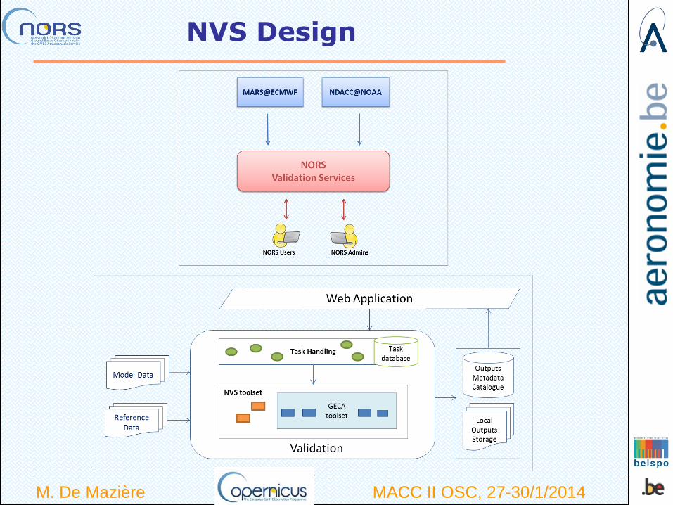
NVS Design
M. De Mazière MACC II OSC, 27-30/1/2014
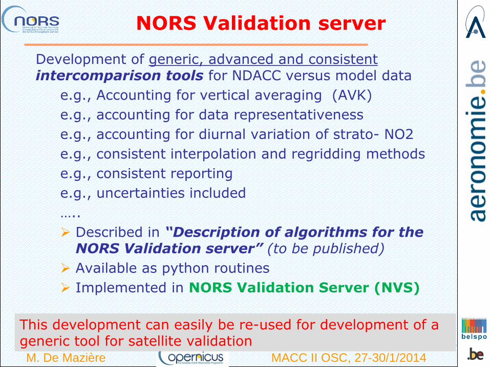
NORS Validation server
Development of generic, advanced and consistent intercomparison tools for NDACC versus model data
e.g., Accounting for vertical averaging (AVK)
e.g., accounting for data representativeness
e.g., accounting for diurnal variation of strato- NO2
e.g., consistent interpolation and regridding methods
e.g., consistent reporting
e.g., uncertainties included
…..
Described in “Description of algorithms for the NORS Validation server” (to be published)
Available as python routines
Implemented in NORS Validation Server (NVS)
This development can easily be re-used for development of a generic tool for satellite validation
M. De Mazière MACC II OSC, 27-30/1/2014
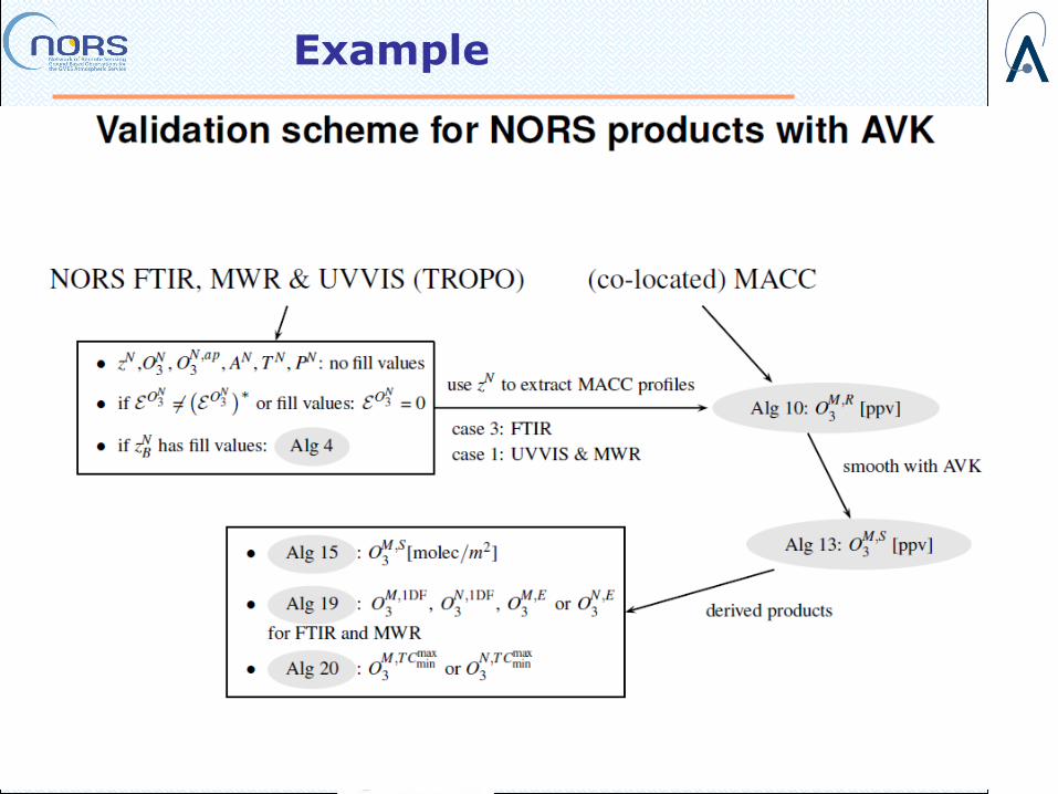
Example
M. De Mazière MACC II OSC, 27-30/1/2014
NORS Validation Server (NVS)
• Screen shot of validation server
M. De Mazière MACC II OSC, 27-30/1/2014
NORS Validation Server

M. De Mazière MACC II OSC, 27-30/1/2014
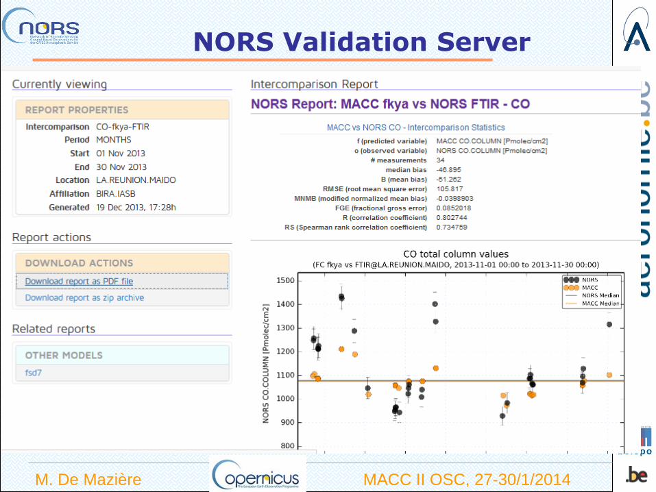
NVS reporting examples
Profile, partial column and total column intercomparisons
+ report including statistics
+ care for traceability

M. De Mazière MACC II OSC, 27-30/1/2014
Example: O3 from microwave spectrometer versus MACC models above Ny-Alesund
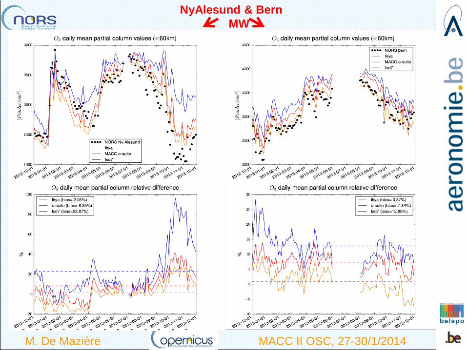
M. De Mazière MACC II OSC, 27-30/1/2014
NyAlesund & Bern
MW
• Acknowledgements: The NORS project has
received funding from the European Community’s
7th Framework Programme (2007-2013) under
grant agreement 284421
Thanks to ESA for letting NORS use the ESA-GECA
heritage
M. De Mazière MACC II OSC, 27-30/1/2014
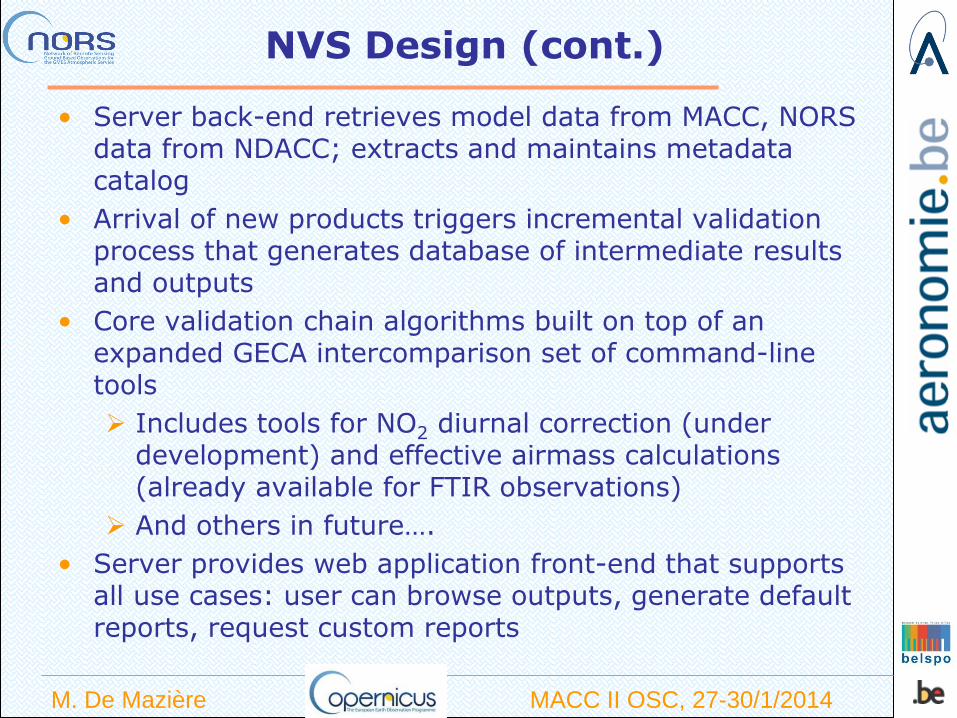
NVS Design (cont.)
• Server back-end retrieves model data from MACC, NORS data from NDACC; extracts and maintains metadata catalog
• Arrival of new products triggers incremental validation process that generates database of intermediate results and outputs
• Core validation chain algorithms built on top of an expanded GECA intercomparison set of command-line tools
Includes tools for NO2 diurnal correction (under development) and effective airmass calculations (already available for FTIR observations)
And others in future….
• Server provides web application front-end that supports all use cases: user can browse outputs, generate default reports, request custom reports
GRUAN ICM-6, Mar 10-14, 2014, Greenbelt, MD, USA
AERI
Task 60 (FTIR reps.): Suitability of Equipment: AERI as a potential GRUAN FTIR
instrument (FTIR)
- Successful contacts with J. Gero in 2013
- TT-AM members recommend AERI representative to be added to TT-AM,
- J. Gero accepted invitation and will coordinate current AERI operations,
and formulate reasonable plans for inclusion into GRUAN

GRUAN ICM-6, Mar 10-14, 2014, Greenbelt, MD, USA
Conclusion (Ground-based)
GRUAN Lidar, Microwave and FTIR Products are slowly, but surely coming
together
- 2014 should see the completion of GRUAN Lidar , GRUAN Microwave,
and GRUAN FTIR Guides
- Version 1 “full scale” GRUAN Lidar Data Stream should be ready by end of 2014
- We are hoping that this will be followed by a “full scale” GRUAN FTIR Data Stream
by end of 2015