taranaki’s pathway to the sea - wordpress.com · 23.10.2014 · province’s most unusual river...
TRANSCRIPT
Ch 3, Clearing the Water — Stony River, Oct 23, 2014 — By Jim Tucker
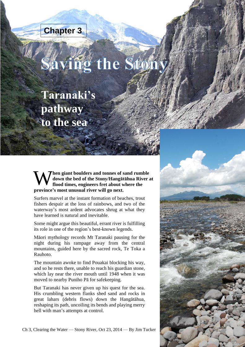
hen giant boulders and tonnes of sand rumble
down the bed of the Stony/Hangātāhua River at
flood times, engineers fret about where the
province’s most unusual river will go next.
Surfers marvel at the instant formation of beaches, trout
fishers despair at the loss of rainbows, and two of the
waterway’s most ardent advocates shrug at what they
have learned is natural and inevitable.
Some might argue this beautiful, errant river is fulfilling
its role in one of the region’s best-known legends.
Māori mythology records Mt Taranaki pausing for the
night during his rampage away from the central
mountains, guided here by the sacred rock, Te Toka a
Rauhoto.
The mountain awoke to find Pouakai blocking his way,
and so he rests there, unable to reach his guardian stone,
which lay near the river mouth until 1948 when it was
moved to nearby Puniho Pā for safekeeping.
But Taranaki has never given up his quest for the sea.
His crumbling western flanks shed sand and rocks in
great lahars (debris flows) down the Hangātāhua,
reshaping its path, uncoiling its bends and playing merry
hell with man’s attempts at control.
W
Taranaki’s
pathway
to the sea
Chapter 3

Ch 3, Clearing the Water — Stony River, Oct 23, 2014 — By Jim Tucker
The destructive floods have become more frequent since the late 1980s, the last big one in 2008 replenishing the sand on beaches all the way to New Plymouth, and possibly beyond.
But it’s unlikely they’re a new phenomenon.
The Māori name of the small town on the edge of the Hangātāhua’s catchment, Okato, means “great flow of water”.
Some attribute that to a tsunami which may have swept Taranaki about 250 years ago, while others believe it refers to the river’s behaviour.
The river is special for reasons other than its celebrated rainbow trout fishery, its astonishingly clear water and its ability to reduce a mountain — it’s the only one in New Zealand with a Local Water Conservation Notice.
The notice - the first of its kind in New Zealand - was gazetted in December, 1985, after a campaign by the Taranaki Acclimatisation Society and a close-knit association of Okato residents and farmers.
They feared their river might be lost to expansion by the petrochemical industry, used for a hydro-electric power scheme, or for large-scale irrigation in Western Taranaki.
In the 1970s, oil companies wanting to develop the province’s gas fields were looking for a location to build heavy industrial plants, and word was out they were attracted by the reliable flow of the Stony.
The threat receded when they settled on sites in North Taranaki at Motunui and Waitara, but Taranaki people were alerted to the possibility the National Government‘s Think Big visions and other economic development might fasten on their environmental taonga.
Today, there are strict controls over anybody discharging into the river or taking any of its water, which makes it as a pristine a waterway as you’ll find.1
Although local farmers say the river’s water doesn’t “keep” because of its headwaters in a swamp, and drinking from it would be unwise for humans because - like all natural waterways - there is risk from cross-species bugs originating in wildlife (giardia, for
instance), by all other measures of purity the river is out on its own.
Paradoxically, that doesn’t always mean it’s teeming with life. Trout and other stream life are cleaned out
whenever there is a major flood, meaning the river’s reputation as one of the best rainbow trout streams occasionally hangs by a nylon thread.
The thread never quite breaks, because Fish and Game NZ, which took over the acclimatisation societies in 1990, still restocks the waterway a couple of times a year with about 100 two-year-old rainbows.
Some rainbows are believed to find their way down from the Ahukawakawa/Moss Swamp in the headwaters between the mountain and the Pouakai Ranges.
They were introduced there many years ago. At left are Fish & Game photographs of stunted rainbow trout found in the swamp.
But most fishers accept that their chances of catching something depend largely on how much time has elapsed since the last big fresh.2
he story of the Hangātāhua/Stony River Local Water Conservation Notice begins with the 1969 discovery of the offshore Maui gas field, then 20th largest in the world.3
Pressure to use the gas to offset the cost of oil mounted after two world oil price shocks in the 70s temporarily increased the price of crude from $US10 a barrel in 1970 to $US90 a decade on.
Prime Minister Rob Muldoon’s National government also had another problem: its take-or-pay contract with the oil companies meant it had to pay for a certain amount of gas each year.
When projected demand for electricity didn’t warrant the building of gas-powered power stations beyond
T

Ch 3, Clearing the Water — Stony River, Oct 23, 2014 — By Jim Tucker
one at Huntly (they would waste 80% of the gas energy, anyway), the government decided to borrow big and build industrial complexes in Taranaki to use gas to make petrol at Motunui, methanol at Waitara, ammonia/urea at Kapuni and liquid petroleum gas at Oaonui.4
The success or failure of Think Big projects has long been debated (they are said to have cost the country about $7 billion to build), but one impact on Taranaki
was to put pressure on the guardians of the province’s environment.
The key one was Taranaki Catchment Commission, whose scientists began investigating the effects of the proposed schemes and other economic growth on the waterscape, especially rivers like the Waitara and
Stony.
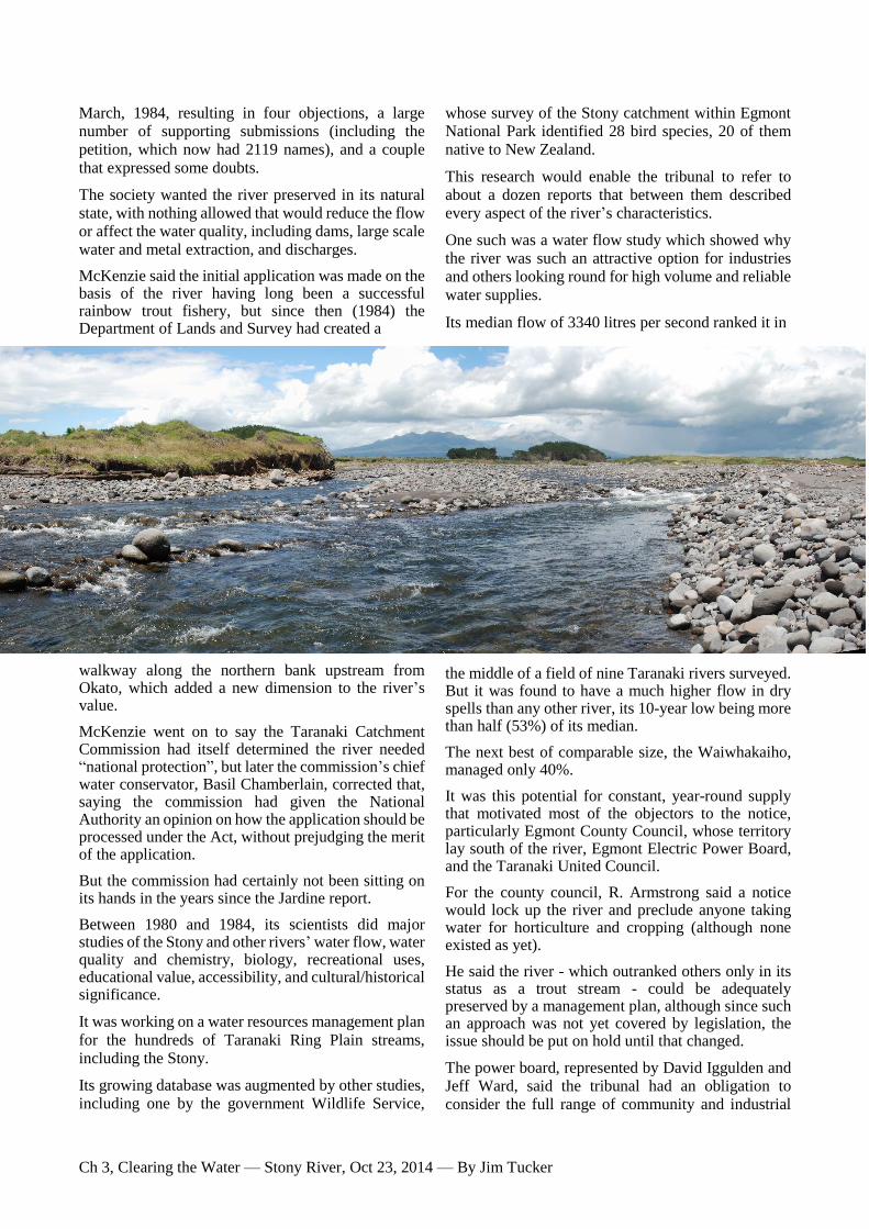
In fact, the commission had already gathered information about the Stony even before the term “Think Big” was invented.5 One of the first studies was a farm-by-farm survey of the 28 kilometre-long Stony catchment done by E. H. Jardine in 1979.6
A glance at the report’s maps and data shows immediately why the river was always going to be ideal for special protection.
Jardine found after it emerges from Egmont National Park, the Stony flows 16.5 kilometres down a narrow strip of farmland whose occupants mostly got their water from bores and wells and - unusual for Taranaki in those days - put next to nothing into the river in the
way of pollution.
It helped that half the farms were sheep and dry stock.
The river catchment is less than a kilometre wide for much of its run to the coast, which meant if there was waste to be discharged
from the 19 dairy farms and a sole pig farm along its banks, it went into streams on either side, the Kaihihi to the north-west and the Werekino in the south.
Unlike many of the province’s rivers, it had no dairy factory on its banks.
The only significant industry disturbing its environment was a metal quarry just downstream from the State Highway 45 bridge south of Okato.
Jardine reported the river was popular for recreation, including tramping, fishing, canoeing and swimming, and already had significant reserve land along its length.
After rushing 12km (and falling 670m) down through
the park, it passed more than 50 hectares of reserves, including the Blue Rata Scenic Reserve7 (then 25.9ha) halfway down, the Ngaweka Pā site just upstream
from Okato, the Okato Rugby Football Club grounds, and 20.23ha of Māori reserve on the southern foreshore at the river mouth.
The 1979 report documented what was already well known to most locals and to recreational users - the Stony/Hangātāhua River is unique in Taranaki: consistently flowing, popular, pristine, culturally and historically significant, and - probably most importantly - enduring little pressure from agriculture.
Jardine also explored the main downside, a propensity for destructive flooding on a scale that clogs up its bed, erodes its banks, changes its course, and on at least a
couple of recent occasions (1998 and 2008), threatens to spill into the neighbouring Kaihihi catchment and sweep into Okato.
he report noted something else that would turn out to be prophetic. Its list of land uses comprised 40 farms, the quarry...and a pottery.
Not just any pottery, because aside from the usual things - a big double-chamber kiln, a restored colonial villa, and a small shop - this one was owned by a couple who over time would become the unofficial guardian neighbours of the river.
It’s a title Lynn and Mike Spencer (below) modestly eschew, even though they have lived on the river’s
shifting northern bank just up from the state highway for 40 years, and were one of the forces behind the Okato community’s 1985 campaign to support the conservation notice.
T

Ch 3, Clearing the Water — Stony River, Oct 23, 2014 — By Jim Tucker
For them, the river began as simply a “back fence” to the three-acre property they bought in 1972 and developed into
a haven of mature trees.
But it would become a significant part of their lives, its shifting swimming holes, flood-time grumbles, attacks on their native tree plantings, and long, innocuous periods of being a
picturesque boundary, featuring in family photo albums.
Ask them what happened in the mid-80s and Lynn will bring out a thick file of papers, including copies of a buff-coloured, A5
pamphlet called Snow to Surf.
The first edition, dated March, 1985, recorded that a public meeting held in Hempton Hall near Okato the previous September drew more than 200
people, and appointed a committee to campaign in support of the Taranaki Acclimatisation Society’s application for a conservation order.
“At least one river as far as possible in its natural state
should be preserved for future generations in Taranaki,” Mike and Lynn Spencer wrote in the pamphlet.
“If any one river is to be considered, the Stony, because of its unique characteristics, should be that river. Historically, the Stony has been largely
untouched and unpolluted. Once the river’s natural state is tampered with, it will be the thin edge of a wedge...”
The pamphlet noted 500 people had signed a petition and committee members had pushed the case with New Plymouth’s National MP, Tony Friedlander, two
neighbouring county councils (Taranaki and Egmont), the Egmont Electric Power Board and other local body representatives.
Support had been pledged by about a dozen organisations, including Taranaki Federated Farmers.
Getting support from farmers was crucial, Lynn recalls. It was fortuitous, she says, one of the farmers whose property bordered the river was former All Black Terry O’Sullivan, a man with an ahead-of-his-time interest in the environment.
He was elected committee chairman, which sent a strong signal to authorities this was not merely a
campaign run by what were then regarded as suspiciously fringe elements, environmentalists.
The committee included other landowners, artist Peter Lambert, representatives from Federated Farmers, the acclimatisation society, surfers, and Phyllis Komene, who represented the Māori community.
By May, more than 2000 people had signed the
petition, the second edition of Snow to Surf reported.
A mass walk was planned for Sunday, May 19. Chairman O’Sullivan urged people to turn out for a two-day hearing that would be held at the Okato Rugby Football Club rooms the following week when a special tribunal set up by the Taranaki Catchment
Commission would hear the case for and against a conservation order.
t that hearing, the three tribunal members appointed by the Taranaki Catchment Commission and Regional Water Board - water
board chairman Tom Watson, board member and New Plymouth Mayor David Lean, and Commissioner of Crown Lands Alistair McIlroy - were told the Taranaki Acclimatisation Society first had concerns in the mid-70s that “large-scale consumptive uses” were planned for the river.8
Society president Bruce McKenzie said the society realised a local conservation notice might be possible after a 1981 amendment to the Water and Soil Conservation Act (1967).
In early 1983, it applied to the Minister of Works and Development, who referred the application to the
Water Board in December. The board advertised it in
A
Ch 3, Clearing the Water — Stony River, Oct 23, 2014 — By Jim Tucker
March, 1984, resulting in four objections, a large number of supporting submissions (including the petition, which now had 2119 names), and a couple
that expressed some doubts.
The society wanted the river preserved in its natural state, with nothing allowed that would reduce the flow or affect the water quality, including dams, large scale water and metal extraction, and discharges.
McKenzie said the initial application was made on the basis of the river having long been a successful rainbow trout fishery, but since then (1984) the Department of Lands and Survey had created a
walkway along the northern bank upstream from Okato, which added a new dimension to the river’s value.
McKenzie went on to say the Taranaki Catchment Commission had itself determined the river needed “national protection”, but later the commission’s chief water conservator, Basil Chamberlain, corrected that, saying the commission had given the National Authority an opinion on how the application should be processed under the Act, without prejudging the merit of the application.
But the commission had certainly not been sitting on its hands in the years since the Jardine report.
Between 1980 and 1984, its scientists did major studies of the Stony and other rivers’ water flow, water quality and chemistry, biology, recreational uses, educational value, accessibility, and cultural/historical significance.
It was working on a water resources management plan
for the hundreds of Taranaki Ring Plain streams, including the Stony.
Its growing database was augmented by other studies, including one by the government Wildlife Service,
whose survey of the Stony catchment within Egmont National Park identified 28 bird species, 20 of them native to New Zealand.
This research would enable the tribunal to refer to about a dozen reports that between them described every aspect of the river’s characteristics.
One such was a water flow study which showed why the river was such an attractive option for industries and others looking round for high volume and reliable
water supplies.
Its median flow of 3340 litres per second ranked it in
the middle of a field of nine Taranaki rivers surveyed. But it was found to have a much higher flow in dry spells than any other river, its 10-year low being more than half (53%) of its median.
The next best of comparable size, the Waiwhakaiho, managed only 40%.
It was this potential for constant, year-round supply that motivated most of the objectors to the notice, particularly Egmont County Council, whose territory lay south of the river, Egmont Electric Power Board, and the Taranaki United Council.
For the county council, R. Armstrong said a notice would lock up the river and preclude anyone taking water for horticulture and cropping (although none existed as yet).
He said the river - which outranked others only in its status as a trout stream - could be adequately preserved by a management plan, although since such an approach was not yet covered by legislation, the issue should be put on hold until that changed.
The power board, represented by David Iggulden and Jeff Ward, said the tribunal had an obligation to consider the full range of community and industrial

Ch 3, Clearing the Water — Stony River, Oct 23, 2014 — By Jim Tucker
needs associated with the river, not just those of conservation and recreation.
It was interested in power generation. Consultants had
looked at potential hydro-electric dam sites on the river, and though none was economically viable for a large state scheme, a small local version might still be desirable in the future, especially if power prices rose more than 50%.
The Taranaki United Council9 was implacably opposed to the application, which it said underestimated the river’s economic value. Council representative John Hutchings said future demands could arise from irrigation, the petrochemical industry and power generation, and denying access to the Stony could put pressure on neighbouring rivers.
A notice would be premature, given the Catchment
Commission’s ring plain water resources survey and the fact a water management plan would soon emerge.
Taranaki County Council (administering territory north of the river) did not formally object to the notice, but believed only half the catchment should be covered.
It said a conservation notice was best restricted to the upper section above Wiremu Rd, where scenic and recreational values were much greater than those of the lower reaches.
County engineer Bob Struthers said apart from being a valuable water supply, the river was the largest
source of river metal in the province.
The amount of rock in the river exceeded the capacity of the river to move it, and in the lower reaches, where the banks were strong enough to resist erosion, the river bed tended to rise.
This meant quarrying below the State Highway 45 bridge was sustainable, and it kept a clear water channel open.
Lawyer Susan Hughes, appearing for Okato Quarries
(below, sole metal supplier to the Okato district), said
the company had been extracting from its site below
the main road bridge for 28 years without damaging the river.
In fact, its operations were regarded by the Taranaki Catchment Commission as “necessary river control works”.
It was in favour of the conservation order, but wanted the section of river where the quarry operated to be excluded.
The acclimatisation society’s counsel, John Macdonald, said the conservation notice - the first of its kind in New Zealand - would not affect existing users like the quarry, and it would not “lock up” the river against future use, as objectors claimed.10
The objectors had failed to establish any current requirements for primary and secondary industry and the applicant was entitled to have its case judged on
the existing situation.
Referring to a precedent called the Rakaia Decision, he said Section 2 of the Water and Soil Conservation Amendment Act 1981 provided for waterways to be recognised and sustained in their natural state, and “multiple use of water resources was not specifically
part of that object”.
Minor water rights that were in the public interest could still be sought by the Crown, and the conservation notice could be revoked if a sufficient case warranted that.
Phyllis Komene, of Nga Mahanga hapu, through
whose lands the river flows, and who spoke at the tribunal hearing on behalf of proclaimed guardians of the maunga, Taranaki Iwi, described the river’s spiritual, cultural, ancestral and historical significance to Māori.
uman interaction with the Hangātāhua goes back more than 1000 years.
Taranaki Museum deputy director Roger Fyfe told the hearing archaeological and historical evidence suggested the river was important to people living in the Okato district since the earliest East Polynesian ancestors of Māori arrived there.
Sand dune erosion at the river mouth occasionally unearthed evidence of a major camp occupied by the moa hunters, he said.
Moa hunters are believed to have moved south as their prey became scarce in the North Island, so there is debate about whether moa still existed in Taranaki by
the time of the great Māori migration around 1300 (variously dated between 1250 and 1350).11
Today’s Maori inhabitants of the area and Puniho Pa, Nga Mahanga hapu, trace their antecedents back multiple generations. Nga Mahanga historian Dennis
H IMAGE: TRC

Ch 3, Clearing the Water — Stony River, Oct 23, 2014 — By Jim Tucker
Ngawhare Pounamu says before them, the people of the mountain were the Kahui Ao, Kahui Po, Kahui Pou and Kahui Atua, who lived on the mountain
ranges.12
People of the Taranaki Iwi whakapapa back to those who arrived in two waka, Kurahaupo and Te Rangimarie-i-te-ao, whose descendants settled at the mouth of the Hangātāhua.
After being delayed by damage suffered when departing Rarotonga, Kurahaupo, whose captain was Te Mounga-roa, landed on the east coast, according to historian Percy Smith. Finding the land already occupied, he
travelled down to Cook Strait and then up the west coast to Taranaki.13
Pounamu says when Kurahaupo arrived, they inter-married rather than conquered the locals.
Although earlier historians included
people from the Aotea waka in the lineage, he says Taranaki is generally distinct from the Aotea settlers to the south, hence the wars between Taranaki and Ngati Ruanui.
Percy Smith’s 1910 account of Māori on the North Island west coast included part of a document — he
called it a cosmogony - showing early ancestors, with the names Rua-Taranaki and Rau-hoto-tapairu listed on line 36 (of 50 lines).
Rua-Taranaki, of the Kahui-maunga people, was believed to be the first man to climb Mt Taranaki, which was renamed after him, having previously been
called by early tangata whenua Puke-haupapa (Ice Hill) and then Puke-o-naki.
Smith: “His wife was Rau-hoto-tapairu, who, at this day, is represented by a large boulder near Cape Egmont, on which are some peculiar markings apparently the work of man.”
Smith recounted the legend of Mt Taranaki’s flight from the central North Island after a failed attempt to seduce Mt Pihanga, and added a long quotation from fellow Taranaki historian, William Henry Skinner.
“Taranaki on his journey from Taupo was preceded by a stone — a female — of great mana, called Toka-a-
Rauhotu, which acted as a pilot, or guide, keeping well in advance of Taranaki.14
"The day preceding the capture of Egmont by Pou-a-kai, Toka-a-Rauhotu had reached a short distance of the coast, on the south side of Wai-wera-iti (Stoney River).”
His account attributed carvings on the rock to a party of Ngati Tama (North Taranaki Iwi), who later dug up the stone (below, at Puniho Pa) and removed it,
although the same night it returned to its resting place.
Smith wrote that the Taranaki people felt wedged in by Te Ati Awa in the north (New Plymouth and
Waitara) and Ngati Ruanui in the south (Opunake south).
Pounamu says there were several wars fought between Taranaki and Te Ati Awa, most of them arising when
elements of the latter either raided into Taranaki or murdered someone.
This trouble reached a peak between 1730 and 1740 when Taranaki persuaded their southern neighbours to join a raid on Te Ati Awa, which was successful.
However, by the turn of the century, the Taranaki
Iwi’s fortunes were reversed as Nga Puhi, Ngati Whatua and Waikato arrived from the north with the weapon that would reshape Māori destiny, the musket.
The Okato/Hangātāhua district would see little lasting peace from this time (early 1800s15) until the end of the third phase of the Taranaki land wars with Pakeha,
the 1881 colonial militia’s “invasion” of peace prophet Te Whiti O Rongomai’s marae at Parihaka (about 15km south of the Hangātāhua).
In the early 1830s, Taranaki people were sometimes driven from their lands by Waikato incursions (Skinner 1935), into the mountains or south, having
little chance against the guns of the northern invaders, who on occasion included their old foes, Te Ati Awa.
But there was a notable exception, closely associated with their biggest river.16
These days, the Hangātāhua’s willfulness is all too apparent just upstream from Mike and Lynn Spencer’s place, on the opposite south-eastern bank.

Ch 3, Clearing the Water — Stony River, Oct 23, 2014 — By Jim Tucker
Bank is the wrong word, for it’s a vertical cliff that rises 20 metres above the river, marking the north-eastern boundary of Ngaweka Pā.
This was the site of a battle Nga Mahanga and neighbouring hapu won with significant help from the cliff, whose foundations have been eroding since the mid-1980s.
Above the river, the pā itself is well-preserved by a
thick overgrowth of native trees, a century-old
reservation order made under the Scenery
Preservation Act 1903, and its tapu status as a burial
ground since it was abandoned as a
dwelling place by Māori before
colonial settlement.
Dominated at the entrance by two lava hillocks, the pā is a rare
example of stone breastwork.
The story of the Nga Mahanga victory over a war party from Waikato about 1820 is well documented by Smith (1910) and later historians writing in Taranaki’s newspapers.17
Accounts passed down say the pā appeared deserted to the invaders, but the defenders suddenly rushed in and used spears up to 18 feet long to drive the enemy through narrow confines of the central area and along a trench to the cliff-top.
Most died after plunging to the rocks below, the only survivors being a last few who fell on the bodies.
Smith wrote that people of the pā hauled up the bodies with supplejack ropes “and then enjoyed the usual feast”, but this was disputed in 1958 in an interview given by one of the descendants of Nga Weka, Iho Komene, who said the dead were accorded burial in a pit at the pā.
The Hangātāhua next features in historical accounts in 1848, when the name emerges of one of its most
famous kaitiaki, Kahu Makura or Minarapa (or Amou) as he was known to Pakeha.
According to New Plymouth historian Brian Scanlan18, Minarapa was asked by Francis Dillon Bell, New Plymouth agent of the colonising New Zealand Company, to guide him and a party (including the surveyor Wellington Carrington19) to the summit of Mount Egmont.
By this time, Minarapa, son of a principal chief, had
travelled to London (1841) and earned the gratitude of the European community when he assisted a scientific
party headed by surveyor Edwin Davy and Robert Gillingham, who explored the coast in 1847 and made
an unsuccessful attempt to climb the mountain from the western side.
In February of the year after the Davy-Gillingham
expedition, Bell decided the Hangātāhua route to the summit was the most accessible and the Taranaki tribe best able to guide him.
He travelled to Whareatea, a pā on the coast north of the river, to get permission to climb what to the Taranaki Iwi is their sacred mountain.20
Minarapa was appointed the guide for Bell and Carrington. He led them to the top, helping them become only the second Europeans to get there21.
En route, they explored the upper reaches of the Hangātāhua, coming across what are today known as Bell’s Falls22, described by Bell as he sketched them as “an object of transcendent sublimity” (Scanlan 1941).

Ch 3, Clearing the Water — Stony River, Oct 23, 2014 — By Jim Tucker
Minarapa lived to a great age into the start of the 20th century on his ancestral lands
at the end of the road named after him, not far from the Hangātāhua.23
He became the keeper of Te Toka a Rauhoto there, periodically removing lichen
growth and painting the rock with a reddish mixture of titoki berries, red kokowai berries and pork fat that had been boiled together (Scanlan 1941).
The rock was removed by Taranaki in 1948 to Puniho Pā, where in one of the meeting houses a coloured photograph (right) of the chief leaning on his precious
charge hangs on the gabled far end of the wharenui.
he second half century of Minarapa’s life saw the greatest changes to the environs of the Hangātāhua.
It was a gradual and at times violent
transformation into a place of European agricultural commerce, as the New Zealand Company acquired land for a constant stream of settlers.
Following uprisings by Taranaki and their neighbouring iwi (starting in Waitara) against the encroachment of settlement, martial law was
declared in Taranaki by Governor Gore Browne in 1860 and there followed two stages of land war in the province that lasted until 1869.
Although a ceasefire was agreed in 1861, fighting began again in 1863, the year Governor George Grey, who had replaced Gore Browne, issued a
proclamation allowing for the confiscation of vast tracts (nearly a million acres — 400,000ha) of Māori-owned Taranaki land from those “engaged in rebellion against Her Majesty’s authority”.24
That meant Taranaki Iwi land, Hangātāhua land.
Some of the battles — Warea, Tataraimaka/Katikara, Omata - were fought on the western ring plain by Taranaki and their allies against British and militia soldiers and contingents of Māori friendly to the provincial government.
The Hangātāhua — by this time also referred to by
the Pakeha-given name, the Stony (or Stoney)25 — is
occasionally mentioned in accounts of the campaigns of Major General Trevor Chute, Major Gustavus Von
Tempsky (who drew the scene
pictured below), Colonel H.J. Warre, and General Duncan Cameron.
It was not referred to as a place of battle but usually for encampment
or discourse while passing through.26
A typical reference is Skinner (1935): “In January, 1865, the Stony River area again comes into the military limelight.
“On Saturday, January 21, Colonel Warre and staff, with the Native Minister (Major Atkinson) and Mr Parris (Native Commissioner), left
New Plymouth, staying the night at Fort St. George,
Tataraimaka27, and the following day met the natives at Tukitukipapa, who there surrendered their arms, and expressed the desire of making peace.
“Riding inland the party proceeded to Ngana, the site of the new military position to be occupied on the north bank of the Stony River, and about one and a
half miles inland from the sea...”
Land north the Hangātāhua began to be parcelled out to those who had served in the military.
“By far the greater portion of the pioneer settlers were military men who had been ‘struck off pay’ and allotted sections in the district,” the 1965 Okato centennial booklet reported.28
T

Ch 3, Clearing the Water — Stony River, Oct 23, 2014 — By Jim Tucker
“In this way 100 men were granted a total area of 11,650 acres of land.”
Hard times beset the province following peace and the
withdrawal of the armed forces, and some of the ex-soldiers were forced to sell their allotments and move away.
Attempts were made to expand on earlier trading success Maori had with the high quality flax grown in the area, but the market failed.
Some hardy pioneers were undeterred, however, and stayed to take up the challenge after 1866, when the name Okato emerges in official records for the first time (Skinner 1935).29
For a decade or so, the Stony was regarded as the boundary
between settlers and Maori, so initially the Taranaki tribe’s land was not occupied after the confiscation and sales.
That changed after 1878,
writes Hohaia: “...after 1878 settlers and surveyors moved into the area south of the Hangaataahua River” (Hohaia 2010).
About this time, a small armed constabulary was
formed by the settlers and stationed at the Okato blockhouse, spending some weeks at one stage “guarding the bridge from threatened destruction by the Maoris” (1965 Centennial booklet).
The constabulary was dispersed in 1884 and members helped build roads “below the Stony River”.
Skinner wrote of his first contact with Okato in 1872 when there were few settlers and he was working as a cadet surveyor on improvements — including bridges - to the South Road between the Katikara and Stony Rivers (Skinner 1935).30
He listed names he recalled — Robert Gray (possibly
the first European settler), Betts, Curtis, Harrod, Andrews, Hempton, Cumming, Collins, Smith, Shaw, Henry, Syme, Jeans, O’Brien, Hawkes, Hogarth, McInnes, Howitt, Meara, Billing, Williams, Pailing, and a survivor of the Light Brigade, Keogh.
The first Stony River bridge was replaced by a larger
version in 1882, the second one doing service until 1929, when a concrete one was built. A bridge over the river upstream to connect inland farms south of the river with Carrington Rd was finished in 1908.
The following year, the county council put up a toll gate on the South Rd at Komene Rd, where it stayed until 1929 (1965 Centennial booklet).
The Stony River invoked much admiration from the settlers.
In a booklet published for the 70th anniversary of Okato in 1935, W.K. Howitt’s reminiscences include: “My mind reverts to my father’s own farm, just down from the old blockhouse, through which the Kaihihi
River ran, while on the boundary the Stony River, to my mind a unique watercourse, threaded its way through its stony bed and walls. 31
“Surely never more crystal stream, cold and icy, ever found its way
to the open sea.
“As boys we often used to lie on the moss-covered banks beside the old Kaihihi; delicate ferns growing
all around us and here and there bush flowers peeping up amongst the leaves and gently
nodding as they were swayed in the breeze.
“Beams of sunshine gleamed fitfully through the inter-
locked branches overhead, which often completely roofed in the river.
“The air was full of the perfume so common to the bush and which can be found nowhere else, and rang with the voices of the native birds, none of which were ever afraid.
“The river, like a thing of life, ran gently past us through meadow and dell, reflecting gloomily the image of the giant trees spreading themselves upon the bank. What a peace of mind as the waters gurgle over the stones through the woodland.”
Most of the woodland was not to last. In his memories
of the latter part of the nineteenth century, Len Andrews wrote in the same 1935 booklet:
“Hundreds of acres were felled every winter in the Okato district, and the burning-off took place the following March when the district would be covered with dense smoke sometimes for two weeks at a time.”
After cutting fern and burning it, the farmers grew wheat for milling, and crops of potatoes, swedes and oats. Cows were milked and butter hand-made, then co-operatives formed and the Crown Dairy Factory

Ch 3, Clearing the Water — Stony River, Oct 23, 2014 — By Jim Tucker
opened about 1894 on the banks of the Kaihihi (the first of several in the Okato/Puniho district).
Andrews recalled his father built his own factory and was the first farmer to own black and white (Friesian) cattle, imported in 1895.
“In earlier days we had reared roan Shorthorns...I can well remember helping to drive sixteen beasts to the Stony River sale.”
In 1904, his father also installed the area’s first milking machine. “Thus began a new era, dairy farming with the drudgery taken out of it.
The resultant increase in the size of the herds (they had milked 130 by hand), the greater use of artificial fertilisers, and the rising prices of butter and cheese, combined to bring prosperity to the dairy farmer and the district.”
hat was it about the river that inspired a reverence not enjoyed by most of the 300 or more waterways that course down from Mt Taranaki?
As mentioned above, it was not used excessively as a drain for cowsheds, nor was a dairy factory built there. Residents, in modern times at least, have drawn their water for drinking and stock from wells and bores, although this may have been something forced on them by the river’s rampaging effects on pumps and piping, or perhaps because they found the water would not keep32.
Sports fishermen have stocked it with rainbow trout since early acclimatisation society days, and still replenish it.
Maori revere it, trampers traverse it, artists paint it33, photographers capture its moods, picnickers sit beside it, swimmers marvel at its clarity, kayakers challenge its rapids, and the Taranaki Regional Council monitors its status and polices its security under the clauses of a unique piece of bureaucracy.
Whether it was the river’s outstanding qualities - recognised from the start by Maori and settlers (Howitt’s “never more crystal stream”) - or just the luck of having such a narrow catchment with alternative water courses close by, the reverence has inspired a lot of paperwork.
Some of its complexity emerged in evidence given to the tribunal hearing in 1985 by Taranaki Catchment Commission staff, Chief Water Conservator Basil Chamberlain and water conservator Fred McLay.
McLay presented what he called a “water resources inventory” for a draft management plan for the river, including hydrology, water quality and land and water uses in the catchment. It was all highly favourable.
The water’s colour and clarity were better than those of other rivers, and the nutrient (phosphate, nitrogen, etc) and bacteria counts were lower, the latter due to only a small area being in the district’s intensive farming zone.
Only one farm extracted water (one other had it as a standby source only) and no water was legally taken for irrigation and rural or community water suppliers. There were no industries using the river water and no power generation.
Chamberlain said there was little likelihood large-scale water demands would be made on the river, but he suggested a tiny amount — 30 litres per second — could be spared for future small domestic, rural and horticultural use without affecting the river’s natural state.
He was indicating there was no need to lock up the river entirely from landholders close by. He said no guarantee could be given the river would not be used by the petrochemical industry, since a local notice could be overridden by the Crown, and every water right application had to be treated on merit.
However, such an eventuality was unlikely in the foreseeable future. If the water conservation notice was granted, the quarry would need a water right, since its activities could be construed as a “river diversion”.34
Not all the paperwork on the river involved water quality and usage. Some reports looked at what was in it, in the way of living creatures and the material the
river transported by the millions of tonnes, sand.
As Phyllis Komene told the hearing, the Hangātāhua was an important source of food for Maori, recognised as far back as 1909 by registration of the fishing grounds at the mouth under Section 232 of the Native Land Act.
W

Ch 3, Clearing the Water — Stony River, Oct 23, 2014 — By Jim Tucker
A co-presenter at the hearing, Lindsay McLeod of the Taranaki Māori Committee, said lamprey eel caught from the river were considered a delicacy.
What else was living in there? To find out, the tribunal could refer to a catchment commission account of the river’s biology published the year before, as part of a three-year study of Taranaki Ring Plain rivers.35
This examined 145 sites in the major rivers and ranked them on width of the water surface, water colour,
clarity, temperature, pH36, river bottom rocks/sand, type of flow, vegetative cover, aquatic flora (plant life), bank vegetation, surrounding environment, developments, and wildlife (fish, birds). The best possible score was 16.5, the worst 36.5.
One of the two Stony sites (upstream at Wiremu Rd) scored second overall (after the Oakura River) with 18.75, with the downstream one not far behind on 21.5. Both scored highly on colour, clarity, temperature, cover, and developments (or lack of them).
The upstream site was strong on bank
vegetation, surrounding environment and wildlife, but did not score so well on aquatic flora; the lower site did poorly on the wildlife count.
The study also inspected 42 reaches in 14 rivers for tiny creatures called
macro-invertebrates, whose presence or absence indicates the health of river water.
Three habitats on the Stony were
tested and the river was found to be
unique among its ring plain cousins,
and explained why rainbow trout
thrive there.
“The turbulent, well-oxygenated water,
(with no finer sediments) combined with the absence of significant organic enrichment (nitrogen/phosphate) ensures a community dominated by mayflies is present along the length of the river,” the report said.37
“Conditions favouring taxa (macro-invertebrates) that
normally are found in typical lowland reaches of rivers (for example, sluggish water, fine organic substrates and dense mats of algae) do not exist in the Stony River and a restricted, organic-enrichment intolerant community exists.” They reported “low species diversity” in the river.
This was later explored further in the fisheries survey part of the study, which compiled 240 fish records
from 26 ring plain catchments over a 21-year period (1962-1983).
This study found only four different species of fish in
the Stony — eels (short-finned and long-finned),
whitebait (koaro and the main whitebait species,
inanga), trout (rainbow and undetermined, probably
brown), and bullies (red-finned and undetermined).
Lamprey eels (piharau) are not mentioned in relation
to the Stony.
hy so few fish? After all, the river scores high on many favourable counts — no weirs to prevent fish migrating, no dairy factory or cowshed discharges, little algal
growth, good tree cover for at least the upper reaches - and significantly disturbed at only one point, at the quarry below State Highway 45.38
Experienced anglers like New Plymouth’s Dave Dannefaerd — who gave evidence at the tribunal
hearing in 1985 - have few doubts about the reason.
He says the big floods clean everything out of the river and it takes time for life to return.
NZ Fish and Game’s Taranaki
field officer, Allen Stancliff, says recent floods in the river in 1990,
1998 (three between July and October), 2004, 2006 and 2008 saw massive erosion in the contributory Pyramid Stream on the mountain slopes.
High vertical banks of ash collapsed and the material was carried downstream to the sea (Fish and Game photo, above left). The river runs grey for months after such events (Fish and Game photo, above).
Most fish and their food (caddis flies and mayflies) are wiped out, the trout either swept away or killed by the
W

Ch 3, Clearing the Water — Stony River, Oct 23, 2014 — By Jim Tucker
erosive effects of the sediment on their gills. But some survive.
Anglers find them in side channels and even in ponds
in farm paddocks. Their food chain re-establishes quite quickly, especially the mayflies, which means surviving fish and those introduced
occasionally by Fish and Game grow quickly.
“When it’s stable, the Stony is still the best rainbow trout fishery in the province.”
The average catch for anglers is two to three kilograms; one of the biggest rainbow a 3.8kg fish caught by Dean Caskey in 1985 (pictured).
The biggest brown trout in recent years was a 4.3kg specimen. Many are returned to the river after being caught.
Each year, he drives over to the Tongariro National Trout Centre in Turangi with a tanker trailer and is given a few hundred two-year-old rainbows remaining
after a “kids’ fish-out day” held there when the trout must be culled.
After a similar fishing day in Stratford, those left over are released into Taranaki rivers like the Stony. For instance, on January 27, 2012, they let go 110 in the catchment off Hoani Rd (above right).
ources of the Stony River are high on the slopes
of Mt Taranaki in two main tributaries. One is
the Stony itself, which flows out of the
Ahukawakawa sphagnum moss swamp, itself
fed by streams from the north-western slopes of the
mountain and the southern side of the Pouakai Ranges.
The swamp is large, with interspersed peat areas, small lakes and ponds, and it acts as a natural flow regulator that ensures the river is fed in the dry summer period.39
The other main tributary is Pyramid Stream, which has
its source below the centre of the collapsed western
side of Mt Taranaki’s peak, which is unstable following the most recent volcanic activity in 1755.
This stream is the culprit when it comes to the
destructive river floods.
Before joining the Stony, it mostly flows through a narrow gorge with near-vertical walls 50m to 100m high, with rapid runoff from high altitudes causing flash floods carrying vast tonnages of boulders, cobbles, gravel and sand.
This ancient and occasional phenomenon - aggravated during early European settlement years by earthquakes dislodging material on the mountain - not only wreaks havoc on river life, but forces suspended
sand out into the sea, where more than half of it is transported northwards in what is known as the littoral drift.40
It forms and replenishes small, normally sand-starved beaches in the rocky bays near river mouths, and is responsible for the renewed health, including enduring sand dunes, of popular swimming sites like Ahu Ahu Rd and Oakura.
And the seemingly overnight formation of a sandy foreshore at the renowned surfboard riding site just north of the river mouth, Kumara Patch.
The Stony is probably the biggest single source of eroded material getting into the sea off Taranaki. In a 2009 thesis for her master of science41, Waikato University student Nicola Anne Cowie wrote in her literature review.
“It was estimated that between 75,000 and 180,000 cubic metres of material enters this coastal system, and streams (principally the Stony River) are the major source of sediment, contributing 43% of the total inputs, followed by cliff erosion.”
Not all the sand goes north, with a quarter of it retained by the river and some even heading south.
Quoting Kear (1979), Cowie wrote: “This longshore sediment transport results in iron sand derived from
S
IMAGES: Fish & Game NZ

Ch 3, Clearing the Water — Stony River, Oct 23, 2014 — By Jim Tucker
Mount Taranaki reaching as far north as Pandora’s Bank [Cape Reinga] and as far south as Paekakariki [just north of Wellington] covering over 480km.”42
To find how significantly Stony River sand affected beaches to the north, every three months between June, 2008, and May, 2009, she surveyed 12 places
between Komene Rd south of the Stony mouth and Back Beach just short of New Plymouth.
Looking at the results of previous studies and aerial photographs, she noted that a marked increase in sand in 2001 (presumably the result of the 1998 Stony flood) was greatly eroded by 2007.
But after the 2008 flood, a resulting influx had got as far north as Ahu Ahu Beach (above).
She concluded the effects of the drift would diminish beyond there and have minimal effects on Back Beach.
And: “...it is possible that the sediment injection will not substantially increase the annual volumes of sediment entering Port Taranaki [which needs regular dredging].”
That study was useful for the Taranaki Regional Council which owns the port, and it appears to have stimulated the council’s interest in erosion and aggradation (riverbed build-up) in all the Ring Plain rivers under its care.
In 2011, it published a report on what was happening
with the riverbeds and what might be done43, along the way acknowledging Cowie’s work and that done previously by an authority on Taranaki’s geology and volcanology, Professor Vince Neall, of Massey University.44
The Stony featured large in the report, which said:
“(It) is the most extreme example of a number of catchments draining Mt Taranaki/Egmont that are experiencing severe, and apparently worsening, erosion in their headwaters, presenting consequent aggradation problems to farming and infrastructure lower down on the Taranaki ring plain.”
Rainfall data suggested accelerated erosion in the Ring Plain rivers between 1994 and 2007 may have
been triggered by a series of particularly large storms in the second half of 1998.
These caused significant damage to many catchments
on Mt Taranaki and probably left them predisposed to higher rates of erosion during subsequent storms.
Peak stream-flow data suggested the frequency and intensity of storm events may have been increasing on Mt Taranaki since at least 1980, which had implications for further severe erosion and aggradation.
A particularly intense storm in April, 2008, caused the Stony to notch up its highest flood peak on record, the report said.
What can be done to tame the Stony?
Not much, it seems, but now it is being closely monitored for change, with council researchers using aerial mapping, and the Institute of Geological and Nuclear Sciences mapping existing landslides on Mt Taranaki using satellite imagery.
The regional council accepts nothing can be done to stop what happens on the mountain, and notes intervention on the Stony below Egmont National Park is controlled by the water conservation notice.
Ch 3, Clearing the Water — Stony River, Oct 23, 2014 — By Jim Tucker
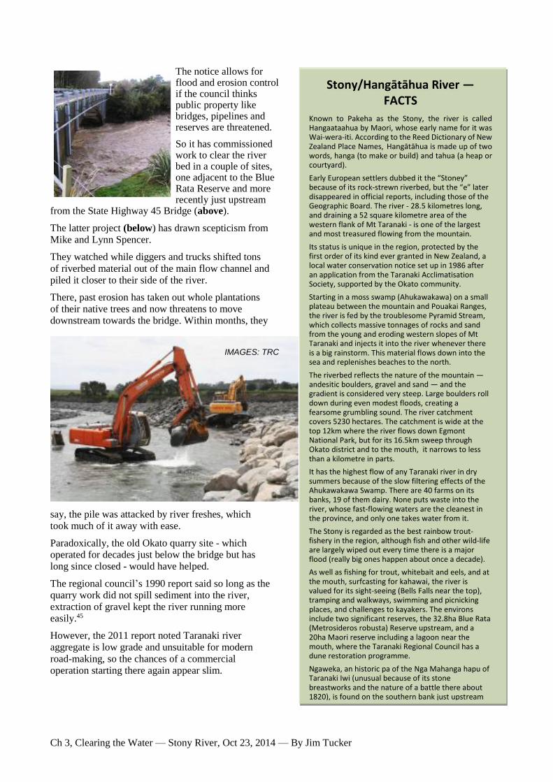
The notice allows for flood and erosion control if the council thinks public property like bridges, pipelines and reserves are threatened.
So it has commissioned work to clear the river bed in a couple of sites, one adjacent to the Blue Rata Reserve and more recently just upstream
from the State Highway 45 Bridge (above).
The latter project (below) has drawn scepticism from Mike and Lynn Spencer.
They watched while diggers and trucks shifted tons
of riverbed material out of the main flow channel and piled it closer to their side of the river.
There, past erosion has taken out whole plantations of their native trees and now threatens to move downstream towards the bridge. Within months, they
say, the pile was attacked by river freshes, which took much of it away with ease.
Paradoxically, the old Okato quarry site - which operated for decades just below the bridge but has long since closed - would have helped.
The regional council’s 1990 report said so long as the quarry work did not spill sediment into the river, extraction of gravel kept the river running more easily.45
However, the 2011 report noted Taranaki river aggregate is low grade and unsuitable for modern
road-making, so the chances of a commercial operation starting there again appear slim.
Stony/Hangātāhua River — FACTS
Known to Pakeha as the Stony, the river is called Hangaataahua by Maori, whose early name for it was Wai-wera-iti. According to the Reed Dictionary of New Zealand Place Names, Hangātāhua is made up of two words, hanga (to make or build) and tahua (a heap or courtyard).
Early European settlers dubbed it the “Stoney” because of its rock-strewn riverbed, but the “e” later disappeared in official reports, including those of the Geographic Board. The river - 28.5 kilometres long, and draining a 52 square kilometre area of the western flank of Mt Taranaki - is one of the largest and most treasured flowing from the mountain.
Its status is unique in the region, protected by the first order of its kind ever granted in New Zealand, a local water conservation notice set up in 1986 after an application from the Taranaki Acclimatisation Society, supported by the Okato community.
Starting in a moss swamp (Ahukawakawa) on a small plateau between the mountain and Pouakai Ranges, the river is fed by the troublesome Pyramid Stream, which collects massive tonnages of rocks and sand from the young and eroding western slopes of Mt Taranaki and injects it into the river whenever there is a big rainstorm. This material flows down into the sea and replenishes beaches to the north.
The riverbed reflects the nature of the mountain — andesitic boulders, gravel and sand — and the gradient is considered very steep. Large boulders roll down during even modest floods, creating a fearsome grumbling sound. The river catchment covers 5230 hectares. The catchment is wide at the top 12km where the river flows down Egmont National Park, but for its 16.5km sweep through Okato district and to the mouth, it narrows to less than a kilometre in parts.
It has the highest flow of any Taranaki river in dry summers because of the slow filtering effects of the Ahukawakawa Swamp. There are 40 farms on its banks, 19 of them dairy. None puts waste into the river, whose fast-flowing waters are the cleanest in the province, and only one takes water from it.
The Stony is regarded as the best rainbow trout-fishery in the region, although fish and other wild-life are largely wiped out every time there is a major flood (really big ones happen about once a decade).
As well as fishing for trout, whitebait and eels, and at the mouth, surfcasting for kahawai, the river is valued for its sight-seeing (Bells Falls near the top), tramping and walkways, swimming and picnicking places, and challenges to kayakers. The environs include two significant reserves, the 32.8ha Blue Rata (Metrosideros robusta) Reserve upstream, and a 20ha Maori reserve including a lagoon near the mouth, where the Taranaki Regional Council has a dune restoration programme.
Ngaweka, an historic pa of the Nga Mahanga hapu of Taranaki Iwi (unusual because of its stone breastworks and the nature of a battle there about 1820), is found on the southern bank just upstream from Okato.
IMAGES: TRC

Ch 3, Clearing the Water — Stony River, Oct 23, 2014 — By Jim Tucker
tramp to the mouth of the river is relatively easy going, through sand dunes at the bottom
of Komene Rd off State Highway 45 and a kilometre or two north along sandy beaches.
In summer, it’s possible to wade across the mouth. Cold water laps over the knees and the current is strong, though, and it’s not hard to imagine the tribulations of mailmen carrying heavy bags across in
the 1840s.
On the south side, the regional council and Taranaki Iwi have a wetland and dune restoration scheme under way.
A small stream coming out to the sea is partly edged by bright orange
algal growth, a byproduct of iron in the land.
The northern side of the river mouth is home to a big colony of black-fronted terns in summer months. If you approach, they move warily
away, but in orderly fashion. Go too far, though, and they all take off in a great white cloud of beating wings.
Behind them and the rocky shore they occupy, dairy farmland starts back up towards Okato.
It’s not high ground, but elevated enough to give a
view of the river’s wide bed and multiple braids just upstream from the single channel that riffles down to meet the surf.
A small stream drops into the river a few hundred metres upstream. It has created
a muddy foreshore covered in plant life and the slight smell of rotting vegetation.
Unusual in a riverbed that is otherwise built relentlessly of stones as far as the eye goes, up towards the mountain.
Grey rocks, boulders, gravel and sand.
A
Stony river, indeed.

Ch 3, Clearing the Water — Stony River, Oct 23, 2014 — By Jim Tucker
NOTES 1 Hangātāhua (Stony) River catchment (TRC) usage rules summarised:
Rule 1 allows water to be taken from the river for domestic, stock-watering and fire-fighting use, provided three stated conditions
are met.
Rule 2 allows water to be taken for agricultural and horticultural activities, but requires a resource consent. This ensures adverse
effects on the environment will be avoided, remedied or mitigated, and also allows the conditions relating to the combined
quantity of the takes and the assessment of alternative sources of water to be enforced. The first two conditions have been
included to limit the amount of water that an individual can take, in order to retain the quantities, flows and levels of water as far
as practicable in their natural state.
Rule 3 prohibits taking water for any purposes other than those allowed by Rules 1 and 2.
Rule 4 prohibits damming, and Rule 5 water diversion except for river and flood control (see Rules 12 and 13).
Rule 6 prohibits the discharge of contaminants or water to the Hangātāhua (Stony) River catchment. The third provision of the
1985 Local Water Conservation Notice said the protected waters included and provided for regionally important fisheries and
angling features, scenic characteristics and recreational features, and cultural, historical and educational features.
Rule 7 provides for the maintenance of existing or authorised structures in the catchment bed as a permitted activity, as long as
the stated conditions can be met.
Rule 8 makes the construction, placement and use of pipelines, roads and bridges a discretionary activity, and says those which
cannot meet the conditions of Rule 7 will a resource consent.
Rule 9 says the use, erection, reconstruction, placement, alteration, extension, removal or demolition of a structure that is not
provided for by Rules 7, 8, 10 or 11 is a prohibited activity.
Rule 10 permits any activity that is restricted under section 13(1) of the Act, and is undertaken by or on behalf of the Taranaki
Regional Council for the purposes of river and flood control, provided that the stated conditions can be met. Provision 6(2)(iv) of
the 1985 Local Water Conservation Notice provided that water rights could be granted and general authorisations made for
activities undertaken for river and flood control purposes pursuant to the Soil Conservation and Rivers Control Act 1941.
Rule 11 concerns River and flood control activities and says where activities undertaken under section 13(1) of the Act for the
purposes of river and flood control cannot meet the conditions of Rule 10, the adverse effects on the environment of the activity
are likely to be more than minor, and the activity should be controlled by means of a resource consent. Requiring a resource
consent for these activities will allow for the regionally important characteristics and features listed in the Local Water
Conservation Notice to be protected.
Rule 12 allows for the diversion of water for the purposes of river and flood control by or on behalf of the Taranaki Regional
Council, so long as the stated conditions can be met. The conditions have been made to ensure that adverse effects on the
environment are minor, and are much the same as the conditions on diversions in other catchments in the region.
Rule 13 says diversions for river and flood control purposes that cannot meet the conditions of Rule 12 are likely to have more
than minor adverse effects on the regionally important characteristics and features that were listed in the Local Water
Conservation Notice. For this reason, it is appropriate that the Taranaki Regional Council control the activity by requiring a
resource consent.
Rule 14 restricts a variety of activities in river and lake beds unless a Plan or a resource consent allows the activity. Because of
the regionally important characteristics and features that were listed in the Local Water Conservation Notice (and which have been
listed in Appendix IA), and in order to continue the protection of the waters of the Hangātāhua (Stony) River catchment, the
activities that are restricted by section 13(1) of the Act, and have not been provided for in other rules, are prohibited.
2 NZ Fish and Game comments about the Stony (Hangātāhua) River: Located near Okato in coastal Taranaki, the Stony has the
best water quality of any ring plain stream. In 1998, a major erosion event in a headwater tributary decimated the fishery and since
then the river has been very unstable. Releases of two-year-old hatchery rainbows provide good angling opportunities during
periods of relative stability. As the Stony is the steepest ring plain catchment, it is prone to flash flooding with heavy rainfall on
the mountain. Nymph or dry fly fishing is recommended. Bait fishing is banned from the entire Stony River.
3 Water conservation notices were introduced in 1968 by the Water and Soil Conservation Act 1967 (Section 20a). The process
was refined by the Water and Soil Conservation Amendment Act 1981 and the Wild and Scenic Rivers Amendment Act 1981,
which sought to protect important water resources through National Water Conservation Orders and Local Water Conservation
Notices. The Resource Management Act 1991 usurped this function, introducing water conservation orders. The Stony’s status is
unusual. It was not only the first waterway to be given a local water conservation notice, it was also the one of only a few before
the RMA took over. Others were Lake Tuakitoto, and the Pomahaka and Lower Clutha Rivers in Otago; the Hautapu River in
Ruapehu; and the Mangatainoka and Makuri Rivers in Wairarapa. Today there are 14 water conservation orders in place,
including Motu River (also subject to a national water conservation order prior to the Stony’s local notice), Rakaia River, Lake
Wairarapa, Manganuioteao River, Lake Ellesmere, Ahuriri River, Grey River, Rangitikei River, Kawarau River, Mataura River,
Buller River, Motueka River, Mohaka River and Rangitata River.
4 P1, Taranaki Catchment Commission, 1984, Freshwater Biology — Taranaki Ring Plain Water Resources Survey. Stratford.
Ch 3, Clearing the Water — Stony River, Oct 23, 2014 — By Jim Tucker
5 Economics commentator Brian Easton is believed to have come up with the label in 1980, following a comment someone made
about “thinking big” at that year’s National Party annual conference: Hembry, Owen, January 31, 2011, In the Shadow of Think
Big. Auckland: http://www.NZHerald.co.nz
6 Jardine, E H, October, 1979, Taranaki Ring Plain Water Resources Survey: Stony River Catchment — Present consumptive,
water and land use, Taranaki Catchment Commission, Stratford.
7 The Blue Rata Reserve is found on the banks of the Stony off Saunders Rd, close to the boundary with Egmont National Park.
The bush is dominated by kamahi (a common, medium sized forest tree in New Zealand), but the reserve is called Blue Rata
Reserve because it is scientifically important as a refuge of the Stony River blue rata (the biggest outside the park). The timber - of
which 2500ha were milled in the 1930s - has dense, blue-tinged timber, straight grain and great strength.
8 Taranaki Catchment Commission, 1986, Stony (Hangātāhua) River Management Plan, Stratford.
9 The Taranaki United Council was an interim provincial council set up in 1979 to unify governance in areas like regional
planning. When national reforms to local government were imposed a decade later, it was absorbed into the new Taranaki
Regional Council, which also incorporated the Taranaki Catchment Commission and Regional Water Board.
10 John Macdonald worked as a lawyer in New Plymouth for 16 years. He was appointed a district court judge at age 39 and
moved to Auckland. In 2006, he was appointed acting warranted district court judge, after retiring from 15 years as a district court
judge in Dunedin.
11 An account by Lieut.-Colonel McDonnell communicated by James Park and read to the Wellington Philosophical Society in
1888 describes a visit to South Taranaki by Governor Sir George Grey during which Grey, McDonnell and others were shown
moa remains in a buried oven near the mouth of the Waingongoro River that supported a story by Kawaua Paipai (then more than
90) that he joined moa hunts on the Waimate Plain when a youth around 1800.
12 Pers. comm. — April 23, 2013, Dennis Ngawhare Pounamu of Nga Mahanga, who is researching and writing a thesis on
Minarapa.
13 Smith, S. Percy, 1910, History and Traditions of the Maoris of the West Coast North Island of New Zealand Prior to 1840,
Thomas Avery, New Plymouth.
14 Skinner (1857-1946) was born in New Plymouth and worked as a surveyor in many parts of the province. A foundation member
of the Polynesian Society in 1892, he wrote a number of histories. His work with Percy Smith on the Maori history of Taranaki,
included in 1935 History and Reminiscences of the Okato District.
15 An early raid by Ngati-Whatua of Kaipara occurred in 1810: P7, Skinner, History of Okato. History and Reminiscences of
Okato 1865-1965. Okato Centennial Committee, Okato.
16 The Waikato invasions were ended in 1837, according to Hôhaia, who said Taranaki defeated the raiders in battles at Te Namu
and finally at Waimate. Te Miringa Hôhaia, 2010, Taranaki tribe — Relationships with other tribes. Te Ara — the Encyclopedia
of NZ. http://www.TeAra.govt.nz/en/taranaki-tribe/2
17 Houston, John, October 3, 1931, “Ancient Fort of Nga-Mahanga Hapu — Defeat of Northern Raiders” Hawera Star, Hawera;
Anon, November 1, 1958. “Nga-weka Pā, where the past haunts the present” Taranaki Herald, New Plymouth; Anon (date
unknown), “Where History Paused, No. 4: Only One Ear...To Bite”, Taranaki Herald.
18 Scanlan, Brian, 1941, extract from: Egmont: The Story of a Mountain — The Chief Minarapa, Reed, Wellington. As well as a
prolific historian, Scanlan was editor of the Taranaki Herald from 1937 to 1965.
19 One of three Carrington brothers who were early surveyors in New Plymouth, the others being Frederic Alonso and Octavius.
20 When returning from their attempt on the summit, Davy and Gillingham were confronted by a Taranaki chief, who insisted their
plant and rock specimens were tapu and must be returned. Quoted from Edwin Davy survr. and Robt. Gillingham, Wednesday,
March 17, 1847, “A report of an exploring expedition from New Plymouth, through the New Zealand Company's settlement, over
part of the middle range, commonly called Batu-wa to Mount Egmont”, Papers relating to provincial affairs - Taranaki. Inspector
of police, Collections of the Alexander Turnbull Library | Manuscripts & Pictorial, Reference Number MS-Papers-0032-0123,
Wellington.
21 They were preceded by scientist Ernst Dieffenbach, who got there on Christmas Day, 1939. Minarapa is considered by many
historians to be probably the first Maori to climb to the summit in modern times.
22 Scanlan said the Pakeha name of the falls came from a Dr Peter Wilson, who in an account written for the Wellington
Independent newspaper called them Dillon Bell’s Cataract (later shortened to Bell’s Falls). Minarapa was the name given to a
stream which flows into Ahukawakawa Swamp just before the falls and also to a bluff, while Carrington’s name was applied to a
ridge which sweeps up on the northern side of the mountain branch of the Hangātāhua. The three successful climbers left their
names in a mustard bottle at the summit “corked with a wad from Minarapa’s mat” (Scanlan 1941).
23 Within a year of the Bell expedition, Minarapa carried the bones of tribal chiefs to a secret burial cave, Te Ana-a-Tahatiti, on
the mountain, said to be the last journey of its kind. When Inspector of Armed Police, Donald McLean appointed Minarapa a
Maori policeman in 1848-49, but when the first Taranaki land wars began in the 1860s he led his people in early attacks on settlers

Ch 3, Clearing the Water — Stony River, Oct 23, 2014 — By Jim Tucker
at Omata. He accepted a truce offer from Governor Grey and handed in his arms in January, 1865, later that year guiding British
troops against the Hauhaus inland of Warea (Scanlan 1941).
24 Wells, B, 1878, History of Taranaki: A standard work on the history of the province, Edmondson & Avery, New Plymouth. The
confiscation prescribed, among other districts, the Oakura Block: Bounded on the north by the sea, on the east by the Omata Block
from the sea to where the boundary of the Omata Block is cut by the native pā running between the Patua and Pouakai ranges,
thence by a straight line running between the above mentioned ranges till it cuts the Hangātāhua river, thence by the Hangātāhua
River to the sea, except the block of land known by the name of Tataraimaka. Wells: “The total area of land north of the
Waingongoro River confiscated under orders in Council and dealt with under the New Zealand Settlements and Continuance Acts
was 934,325 acres. Of this area, 47,800 acres were laid out as Military Settlements; viz.,45,681 acres as rural lands, 1,115 acres as
suburban, and 1,004 in townships. The districts were Pukearuhe, Urenui, Tikorangi, Huirangi, Manganui, Mataitawa, Manutahi,
Oakura, Koru, Ahuahua, and Okato. Of the total area confiscated, 35,000 acres were allotted to the Military Settlers, 6,622 acres
were returned to the natives or reserved for their use, and the remainder was allotted for education and other reserves, or devoted
to roads.
25 Skinner, 1935: “In the early days of the New Plymouth settlement, 1841-1865, the seaward and southern portion of the district
was known as ‘Stoney River’. This name was coined by one of the European mailmen of the 1840s, Thomas Heale...He, with
other hardy and determined constables of that period...swagged Her Majesty’s mails on foot along the coast to the mission station
at Waimate (near Manaia)...The Hangātāhua was reckoned one of the roughest and most unsafe river crossings along the whole
coastal route, and to those who had to ford it in the early days and during the Maori War period, all considered the name ‘Stoney
River’ fitted the formation of its bed and difficult crossing.”
26 Cowan, James, 1956, New Zealand Wars: A History of the Maori Campaigns and the Pioneering Period: Volume II: The
Hauhau Wars, (1864—72), R.E.Owen, Wellington.
27 Scene of the last battle (1863) fought by Taranaki iwi warriors on the Okato block, when 30 of them were killed (Skinner 1935).
28 P47, Anon, 1965, History and Reminiscences of Okato 1865-1965, Okato Centennial Committee.
29 Skinner (1935) disputed an early claim the name Okato came from a blockhouse hill dominating the settlement. He preferred an
account from early settler and local historian W.J. Gray (whose house stood across the Hangātāhua from Ngaweka Pā), who
believed the name O-kato derived from a tidal wave which swept the Taranaki coast in the mid-1700s, destroying villages and
killing many people. “The word O-kato, a composite word, as given in Williams’ dictionary, means: Kato, flowing, flood (of the
tide only); O, the prefix, in this case meaning ‘the’ or ‘of’, so a free translation might be given as ‘A flooding (of the) tide’. Lyn
and Mike Spencer say there is some doubt about this and believe there may be equal validity in linking the name to the
Hangātāhua’s frequent flooding.
30 Not long prior to Skinner’s surveying work, access to the district was from the beach.
31 Reproduced in the 1965 centennial publication.
32 During his survey in 1979, Jardine was told Stony River water would not stay fresh when stored, but he said Taranaki
Catchment Commission scientists were unable to confirm that with tests. The storage problem was confirmed to the author in
2012 by well-known dairy industry veteran Don Harvey, who owns several farms in the district. He says the problem appears to
come from the river’s source in the moss swamp. Okato and nearby rural areas took water from the Mangatete Stream in the
Kaihihi catchment.
33 Coastal artist Peter Lambert presented four of his paintings at the 1985 tribunal hearing to demonstrate the challenges faced
when capturing the river, difficulties posed by the river’s clarity, volume and rapid movement.
34 The quarry had been operating with only a shingle extraction permit, and after the Local Water Conservation Notice was
granted by the tribunal, it was told to gain a water right from the commission. It received one in June, 1986.
35 Taranaki Catchment Commission, April, 1984, Freshwater Biology — Taranaki Ring Plain Water Resources Survey, Stratford.
This was part of a large Catchment Commission study of the ring plain rivers, approved by the National Water and Soil
Conservation Organisation in November, 1979, and done in response to an increasing demand for information brought on by the
Think Big projects, expanding horticulture, greater hygiene requirements for dairy sheds and rising consumption by communities
in general. The industrial projects included an ammonia/urea plant at Kapuni, a liquid petroleum gas project at Oaonui, a methanol
plant either in the Waitara Valley or at Omata, and a synthetic petrol plant in the Waitara area. Low river levels in summer meant
high demand for processing and cooling could damage any rivers involved. The study would look at surface hydrology,
groundwater hydrology, water quality, water and land use, recreation and freshwater biology. The commission’s scientists
examined 145 sites.
36 pH means potential hydrogen and is a measure of water’s alkalinity/acidity. Pure water has a pH close to 7.
37 P130, Freshwater Biology — Taranaki Ring Plain Water Resources Survey.
38 Quarries are far from beneficial. The 1984 freshwater biology report (p179) says quarrying and impoundment causes scouring
or movement of the riverbed, and siltation from bed movement and crusher plant washings are detrimental to fish life. Scouring
unstabilises the riverbed and disturbs the invertebrate communities, consequently reducing the fish food supply, and also may
reduce the availability of instream cover and so affect territorial behaviour of fish. Sediment can kill the fish or reduce growth

Ch 3, Clearing the Water — Stony River, Oct 23, 2014 — By Jim Tucker
rates and disease resistance, and prevent development of fish eggs and larvae. It can cause fish to modify their natural movements
or migrations, reduce their available food, and make them harder to catch.
39 Taranaki Regional Council, 1990, Stony (Hangātāhua) River Bed Survey, Stratford. The report said loosely jointed lava flows
on the north-western side of the mountain, some resting on loose gravel, had contributed to at least 11 large debris flows over the
previous 400 years, with the western crater rim being the source of a number of them. Following eruptions in 1500, debris washed
down the Stony in a large flood covering 15 square kilometres of what is now Okato farmland. A debris flow in 1890 destroyed
the bush from Pyramid Stream to the boundary of the park.
40 Two events of note occurred prior to 1990, the TRC report said: “The first of these major floods was in 1905 when a five metre-
high ‘wall of water, rocks and logs’ swept away a smithy’s shop located downstream of the main highway bridge...Then in
February 1935 the Stony River was diverted by rocks and shingle near the Blue Rata Reserve. Some flood water is alleged to have
flowed into the Kaihihi Stream ad damaged the Oxford Road Dairy Factory...In other floods water levels have been known to
approach the bottom of the State Highway 45 bridge...The supply of aggregate to the Stony River is thought to be dominated by
individual erosion events rather than a continual erosion process in the upper catchment.”
41 Cowie, Nicola Anne, 2009, Monitoring the Coastal Sand Wedge Outbreak from the Stony River, Taranaki, University of
Waikato, Hamilton.
42 Kear, D, 1979, Geology of ironsand resources of New Zealand: Dept of Scientific and Industrial Research, Wellington.
43 Taranaki Regional Council, July, 2011, Aggradation in Rivers and Streams of the Taranaki Ring Plain, Stratford.
44 Ibid, P12. “The Egmont Volcanic Centre has attracted much scientific interest for many years. There is geological interest as
well as the specialist volcanology interest and the acknowledged authority in both fields is Professor Vince Neall of Massey
University. He has had a long association with the mountain and has authored and been associated with a vast range of papers,
research and reports related to pedology, geology and volcanology of Taranaki. He has prepared a number of reports for Council,
especially relating to the Stony River and plays an active part in the Egmont Scientific Advisory Group.
45 Taranaki Regional Council, 1990, Stony (Hangātāhua) River Bed Survey.