talisman saber 2017 - defence.gov.au · aecom talisman saber 2017 commercial-in-confidence...
TRANSCRIPT

21-Feb-2016 Prepared for – Department of Defence – ABN: 68706814312
Department of Defence
21-Feb-2016
Commercial-in-Confidence
Talisman Saber 2017 Public Environment Report

AECOM Talisman Saber 2017 Commercial-in-Confidence
21-Feb-2016 Prepared for – Department of Defence – ABN: 68706814312
Talisman Saber 2017 Public Environment Report
Client: Department of Defence
ABN: 68706814312
Prepared by
AECOM Australia Pty Ltd Level 10, Tower Two, 727 Collins Street, Melbourne VIC 3008, Australia T +61 3 9653 1234 F +61 3 9654 7117 www.aecom.com ABN 20 093 846 925
21-Feb-2016
Job No.: 60517266
AECOM in Australia and New Zealand is certified to ISO9001, ISO14001 AS/NZS4801 and OHSAS18001.
© AECOM Australia Pty Ltd (AECOM). All rights reserved.
AECOM has prepared this document for the sole use of the Client and for a specific purpose, each as expressly stated in the document. No other party should rely on this document without the prior written consent of AECOM. AECOM undertakes no duty, nor accepts any responsibility, to any third party who may rely upon or use this document. This document has been prepared based on the Client’s description of its requirements and AECOM’s experience, having regard to assumptions that AECOM can reasonably be expected to make in accordance with sound professional principles. AECOM may also have relied upon information provided by the Client and other third parties to prepare this document, some of which may not have been verified. Subject to the above conditions, this document may be transmitted, reproduced or disseminated only in its entirety.

AECOM Talisman Saber 2017 Commercial-in-Confidence
21-Feb-2016 Prepared for – Department of Defence – ABN: 68706814312
Quality Information
Document Talisman Saber 2017
Ref 60517266
Date 21-Feb-2016
Prepared by Anneke Monte, James O'Donnell, Natalie Isaac, Daniel Lim, Jonathan Billington, Anna Hertle, Amelia Mack, Luke Kirkwood, Victoria Chantra
Reviewed by Matthew MacFarlane, Abe Francis, Colin Trinder and John Polglaze
Revision History
Revision
Revision Date Details Authorised
Name/Position Signature
1 11-Nov-2016 Draft Matthew MacFarlane Group Director - Southern Australia
2 16-Dec-2016 Final Matthew MacFarlane Group Director - Southern Australia
3 25-Jan-2017 Final Matthew MacFarlane Group Director - Southern Australia
4 21-Feb-2017 Revised Final Matthew MacFarlane Group Director - Southern Australia

AECOM Talisman Saber 2017 Commercial-in-Confidence
21-Feb-2016 Prepared for – Department of Defence – ABN: 68706814312
Table of Contents Executive Summary i 1.0 Introduction 1
1.1 Background and objectives of Exercise TS17 1 1.2 Justification for the Exercise 1 1.3 Operational and Environmental Management Context 1 1.4 Locations 2 1.5 Environmental assessment background 6 1.6 TS17 status and timeframe 6 1.7 PER objectives 6 1.8 Community and stakeholder consultation 6 1.9 PER structure 7
2.0 Methods 8 2.1 General approach 8
Flora and fauna review methods 8 2.1.1 Heritage review methods 10 2.1.2
2.2 Environmental Risk Assessment 11 2.3 EPBC Act Significance Test 12
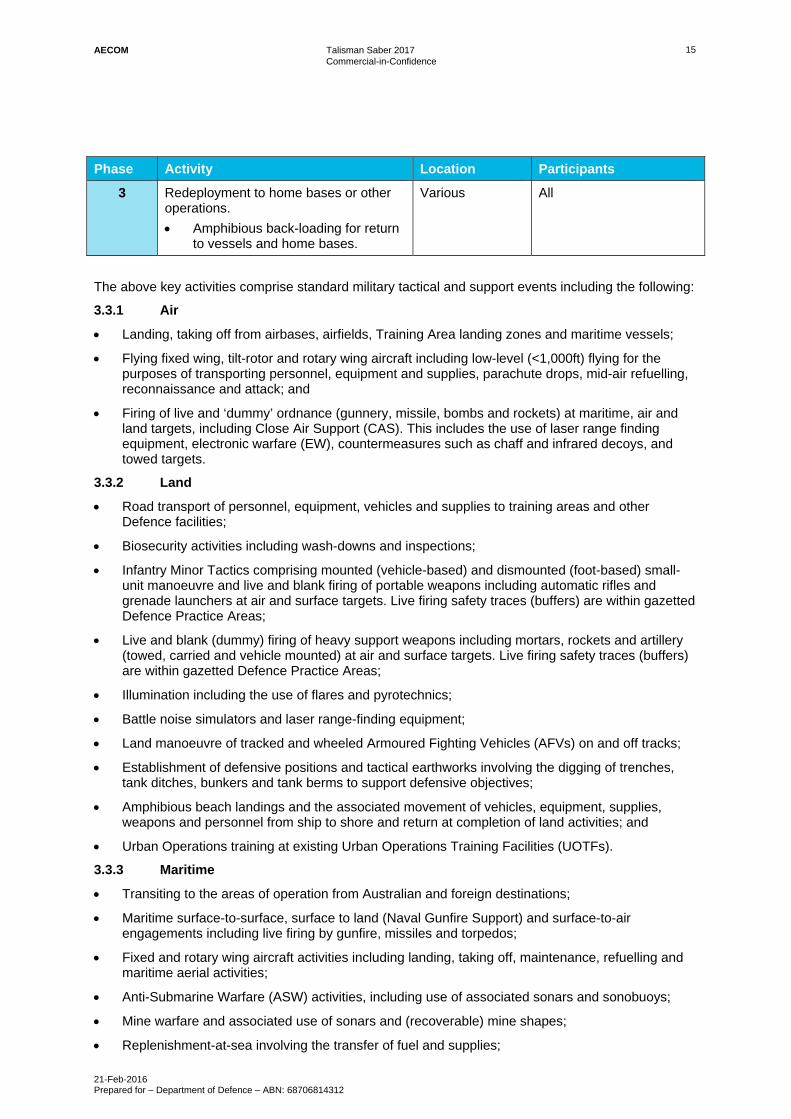
3.0 Description of Exercise TS17 13 3.1 Exercise objectives 13 3.2 Participants 13 3.3 Planned activities 13
Air 15 3.3.1 Land 15 3.3.2 Maritime 15 3.3.3 Administration and Control 16 3.3.4
3.4 Weapons and equipment 16 3.5 Timeframe for TS17 16 3.6 How exercise TS17 compares to TS15 and other previous exercises 17 3.7 Alternatives to TS17 17
Taking no action 17 3.7.1 Using another location 17 3.7.2 Alternative locations, time frames or activities that form part of the 3.7.3
action 18 A staged development or component of a larger action 18 3.7.4 Relationship of the action to other developments or actions 18 3.7.5
4.0 Context 19 4.1 Commonwealth legislation, State and Territory legislation 19 4.2 International conventions and agreements 19 4.3 Recovery Plans 19 4.4 Other agreements 20
Great Barrier Reef Marine Park Memorandum of Understanding 20 4.4.1 Permissive Occupancy Agreement for the Intertidal Zone – Stanage 4.4.2
Bay amphibious landing 21 4.5 Defence Policies and Operational Controls 21 4.6 Previous environmental impact assessment 22 4.7 Consultation 23 4.8 Social and economic aspects 24 4.9 Health and safety 25
5.0 TS17 sites - Descriptions, values and site-specific control measures 26 5.1 Shoalwater Bay Training Area 26
Location and access 26 5.1.1 Existing values 26 5.1.2 Potential impacts 26 Site specific-policies, plans and control measures 27 5.1.4
5.2 Townsville Field Training Area 29

AECOM Talisman Saber 2017 Commercial-in-Confidence
21-Feb-2016 Prepared for – Department of Defence – ABN: 68706814312
Location and access 29 5.2.1 Existing values 29 5.2.2 Potential impacts 29 5.2.3 Site-specific policies, plans and control measures 29 5.2.4
5.3 Cowley Beach Training Area 31 Location and access 31 5.3.1 Existing values 31 5.3.2 Potential impacts 31 5.3.3 Site-specific policies, plans and control measures 32 5.3.4
5.4 Mount Bundey Training Area 34 Location and access 34 5.4.1 Existing values 34 5.4.2 Potential impacts 34 Site-specific policies, plans and control measures 34 5.4.4
5.5 Halifax Bay Training Area 36 Location and access 36 5.5.1 Existing values 36 5.5.2 Potential impacts 36 5.5.3 Site-specific policies, plans and control measures 36 5.5.4
5.6 Stanage Bay area 38 Location and access 38 5.6.1 Existing values 38 5.6.2 Potential impacts 39 Site-specific policies, plans and control measures 39 5.6.4
5.7 Timor and Arafura Seas 41 Location 41 5.7.1 Existing values 41 5.7.2 Potential impacts 41 5.7.3 Site-specific policies, plans and control measures 41 5.7.4
5.8 Coral Sea (including Saumarez Reef Air Weapons Range) 42 Location 42 5.8.1 Existing values 42 5.8.2 Potential Impacts 43 5.8.3 Site-specific policies, plans and control measures 43 5.8.4
5.9 RAAF bases and civil airports 44 5.10 Depots and staging sites 45 5.11 Port facilities 46
6.0 Risk Assessment 48 6.1 Initial risk assessment findings 48 6.2 Residual Risk Assessment Findings 48
7.0 Measures to avoid or reduce impacts 49 7.1 Potential Impacts and source activities 49 7.2 Information and controls for specific issues of concern 54
Weed management 54 7.2.1 Quarantine 55 7.2.2 Fire Management 55 7.2.3 Terrestrial wildlife 56 7.2.4 Marine wildlife, including whales and other cetaceans 57 7.2.5 Endangered ecological communities or sensitive habitats 58 7.2.6 Waste management 59 7.2.7 Low flying aircraft noise 60 7.2.8 Light Spill 61 7.2.9 Nuclear-powered vessels 62 7.2.10 Coastal Erosion 62 7.2.11 Watercourses 62 7.2.12 Acid Sulfate Soils 63 7.2.13 Heritage 63 7.2.14 Land and water contamination 64 7.2.15
AECOM Talisman Saber 2017 Commercial-in-Confidence
21-Feb-2016 Prepared for – Department of Defence – ABN: 68706814312
POL or Chemical Spills 65 7.2.16 Aircraft emergency fuel dumping 66 7.2.17 Fires aboard vessels 66 7.2.18 Jamming signals 66 7.2.19 Nuclear activities and prohibited weapons 66 7.2.20 High explosive residues 67 7.2.21 Aircraft crashes 67 7.2.22
7.3 Environmental roles and responsibilities 67 7.4 Environmental awareness 69 7.5 EMG and Environmental Monitoring during TS17 69 7.6 Post-exercise environmental reporting 70 7.7 Community and stakeholder consultation 72 7.8 Exercise operational controls 72
TS17 Environmental Management Plan (EMP) 72 7.8.1 TS17 Combined Exercise Instruction (CEI) 72 7.8.2 Operation Orders (OPORDs) 72 7.8.3 Environmental Clearance Certificates (ECC’s) 72 7.8.4
8.0 EPBC Act significant impact tests and permits 73 8.1 Matters of National Environmental Significance 73
World Heritage Properties 73 8.1.1 National Heritage places 83 8.1.2 Wetlands of International Importance 84 8.1.3 Listed threatened species 86 8.1.4 Listed threatened ecological communities 90 8.1.5 Listed migratory species 92 8.1.6 Great Barrier Reef Marine Park 94 8.1.7 Nuclear actions 97 8.1.8 The Commonwealth marine environment 97 8.1.9 Protection of water resources from coal seam gas development and 8.1.10
large coal mining development 100 8.2 The whole of environment on Commonwealth land or actions by a
Commonwealth agency 100 Impacts on landscapes and soils 101 8.2.1 Impacts on coastal landscapes and processes 102 8.2.2 Impacts on ocean forms, ocean processes and ocean life 103 8.2.3 Impacts on water resources 105 8.2.4 Pollutants, chemicals, and toxic substances 106 8.2.5 Impacts on plants 107 8.2.6 Impacts on animals 110 8.2.7 Impacts on people and communities 111 8.2.8 Impacts on heritage 113 8.2.9
8.3 Principles of ecologically sustainable development 114 8.4 Other matters protected by the EPBC Act 115
Critical Habitats 115 8.4.1 Recovery and Threat Abatement Plans 116 8.4.2 Wildlife Conservation Plans 122 8.4.3 World Heritage Areas 122 8.4.4 Ramsar wetlands 122 8.4.5 Biosphere Reserves 123 8.4.6 Commonwealth Reserves (Marine or Terrestrial) 123 8.4.7
9.0 EPBC Act Permit Requirements 124 10.0 Conclusion 125 11.0 References 126
Appendix A Defence Environment Risk Tool A
Appendix B TS17 Platforms and weapons B

AECOM Talisman Saber 2017 Commercial-in-Confidence
21-Feb-2016 Prepared for – Department of Defence – ABN: 68706814312
Appendix C Commonwealth, State and Territory Legislation C
Appendix D MNES Recovery Plans D
Appendix E Defence Policies, Procedures and Guidelines E
Appendix F Shoalwater Bay Training Area PMST Search Results F
Appendix G Townsville Field Training Area PMST Search Results G
Appendix H Cowley Beach Training Area PMST Search Results H
Appendix I Mt Bundey Training Area PMST Search Results I
Appendix J Halifax Bay Training Area PMST Search Results J
Appendix K Stanage Bay area PMST Search Results K
Appendix L Timor and Arafura Seas PMST Search Results L
Appendix M Coral Sea PMST Search Results M
Appendix N MNES species likelihood of occurrence assessment N
Appendix O Shoalwater Bay Training Area Environment and Heritage Values O
Appendix P Townsville Field Training Area Environment and Heritage Values P
Appendix Q Cowley Beach Training Area Environment and Heritage Values Q
Appendix R Mount Bundey Training Area Environment and Heritage Values R
Appendix S Halifax Bay Training Area Environment and Heritage Values S
Appendix T Stanage Bay Environment and Heritage Values T
Appendix U Timor and Arafura Seas Environment and Heritage Values U
Appendix V Coral Sea Environment and Heritage Values V
Appendix W World Heritage Values W
Appendix X Ramsar wetland values for TS17 sites X
Appendix Y Risk Assessment Results Y
AECOM Talisman Saber 2017 Commercial-in-Confidence
21-Feb-2016 Prepared for – Department of Defence – ABN: 68706814312
Appendix Z Critically Endangered Species – Nature and Extent of Likely Impacts Z
Appendix AA Endangered Species - Nature and Extent of Likely impacts AA
Appendix BB Vulnerable Species - Nature and Extent of Likely Impacts BB
Appendix CC Threatened Ecological Communities - Nature and Extent of Likely Impacts CC
Appendix DD Migratory Species - Nature and Extent of Likely Impacts DD
Appendix EE Cetaceans - Nature and Extent of Likely Impacts EE
Appendix FF Marine species – Nature and Extent of Likely impacts FF
List of Figures
Figure 1 General locality of training areas and support activities for TS17 5 Figure 2 Personnel by nation and service 13 Figure 3 Shoalwater Bay Training Area Locality Plan 28 Figure 4 Townsville Field Training Area Locality Plan 30 Figure 5 Cowley Beach Training Area Locality Plan 33 Figure 6 Mount Bundey Training Area Locality Plan 35 Figure 7 Halifax Bay Training Area 37 Figure 8 Stanage Bay Area Locality Plan 40
List of Tables
Table 1 Exercise Training Areas 3 Table 2 Exercise Maritime areas 4 Table 3 Likelihood of occurrence definitions for MNES species 10 Table 4 Planned activities by phase, location and participants 14 Table 5 RAAF bases and civil airports to be used for TS17 44 Table 6 Depots and staging sites to be used for TS17 46 Table 7 Port facilities to be used for TS17 46 Table 8 Medium and High risks, activities with the potential to cause an impact and
section to refer to for mitigation measures 49 Table 9 TS17 environmental management Defence roles and responsibilities 67 Table 10 TS17 Defence Groups environmental management roles and responsibilities 68 Table 11 TS17 environmental management – post-Exercise environmental reporting 71 Table 12 Attributes, potential impacts and management approaches for the Great Barrier
Reef WHA 75 Table 13 Attributes, potential impacts and management approaches for the Wet Tropics
WHA 78 Table 14 Attributes, potential impacts and management approaches for Kakadu WHA 80 Table 15 Significant Impact Assessment – World Heritage Areas 82 Table 16 Significant Impact Assessment - National Heritage places 83 Table 17 Significant Impact Assessment - Wetlands of International Importance 85 Table 18 Threatened species with a moderate or greater likelihood of occurrence at TS17
sites 87 Table 19 Significant Impact Assessment – Critically Endangered, Endangered and
Vulnerable Species 88 Table 20 Significant Impact Assessment - Threatened ecological communities 91

AECOM Talisman Saber 2017 Commercial-in-Confidence
21-Feb-2016 Prepared for – Department of Defence – ABN: 68706814312
Table 21 Significant Impact Assessment – Terrestrial Migratory Species 93 Table 22 Significant Impact Assessment – Marine Migratory Species 93 Table 23 Significant Impact Assessment - Great Barrier Reef Marine Park 95 Table 24 Listed marine and cetacean species with a moderate or greater likelihood of
occurrence in Commonwealth marine areas in the Coral, Timor and Arafura Seas 98
Table 25 Significant Impact Assessment - Commonwealth marine environment 99 Table 26 Significant Impact Assessment – landscape and soils 101 Table 27 Significant Impact Assessment – coastal landscapes and processes 102 Table 28 Significant Impact Assessment – ocean forms, ocean processes and ocean life 103 Table 29 Significant Impact Assessment – water resources 105 Table 30 Significant Impact Assessment – pollutants, chemicals and toxic substances 106 Table 31 Significant Impact Assessment – plants 107 Table 32 Significant Impact Assessment – animals 110 Table 33 Significant Impact Assessment – people and communities 111 Table 34 Significant Impact Assessment – heritage 113 Table 35 Compliance with principles of ecologically sustainable development 115 Table 36 Significant impact Assessment – Recovery Plans 117 Table 37 Significant Impact Assessment – Wildlife Conservation Plans 122 Table 38 Risk Assessment Matrix A-1 Table 39 Likelihood descriptors A-1 Table 40 Consequence descriptors A-2 Table 41 Ships B-1 Table 42 Small craft B-1 Table 43 Aircraft – Rotary Wing B-2 Table 44 Aircraft – Fixed Wing B-2 Table 45 Land vehicles B-3 Table 46 Land Weapons B-4 Table 47 Other B-4 Table 48 Commonwealth, State and Territory Legislation applicable to TS17 C-1 Table 49 Recovery Plans and their objectives and requirements D-1 Table 50 Defence policies, procedures and guidelines E-1 Table 51 Likelihood of occurrence of critically endangered and endangered species N-1 Table 52 Likelihood of occurrence of Vulnerable species N-17 Table 53 Likelihood of occurrence of Migratory Marine Birds N-41 Table 54 Likelihood of Occurrence of Migratory Wetland Species N-45 Table 55 Likelihood of Occurrence of Migratory Terrestrial Species N-54 Table 56 Likelihood of Occurrence of Migratory Marine Species N-58 Table 57 Likelihood of Occurrence of Cetacean species N-66 Table 58 Likelihood of occurrence of Marine Fish species (Signathids) N-70 Table 59 Likelihood of occurrence of marine reptile species N-76 Table 60 Shoalwater Bay Training Area Environment and Heritage values O-1 Table 61 Townsville Field Training Area Environment and Heritage Values P-1 Table 62 Cowley Beach Training Area Environment and Heritage Values Q-1 Table 63 Mount Bundey Training Area Environment and Heritage Values R-1 Table 64 Halifax Bay Training Area Environment and Heritage Values S-1 Table 65 Stanage Bay Environment and Heritage Values T-1 Table 66 Timor and Arafura Seas Environment and Heritage Values U-1 Table 67 Coral Sea Environment and Heritage Values V-1 Table 68 World Heritage Values W-1 Table 69 Ramsar wetland values for TS17 sites X-1 Table 70 Residual Risk Assessment – Medium and High risks with standard and
additional TS17 mitigation measures applied Y-1 Table 71 Nature and extent of likely impacts to Critically Endangered species with a
likelihood of occurrence of Moderate or greater in TS17 activity areas Z-1 Table 72 Nature and extent of likely impacts to Endangered species with a likelihood of
occurrence of Moderate or greater AA-1
AECOM Talisman Saber 2017 Commercial-in-Confidence
21-Feb-2016 Prepared for – Department of Defence – ABN: 68706814312
Table 73 Nature and extent of likely impacts to Vulnerable species with a likelihood of occurrence of Moderate or greater in TS17 activity areas BB-1
Table 74 Nature and extent of likely impacts to threatened ecological communities with a likelihood of occurrence of Moderate or greater in TS17 activity areas CC-1
Table 75 Nature and extent of likely impacts to migratory marine mammals with a likelihood of occurrence of Moderate or greater in TS17 activity areas DD-1
Table 76 Nature and extent of likely impacts to migratory birds with a likelihood of occurrence of Moderate or greater in TS17 activity areas DD-2
Table 77 Nature and extent of likely impacts to migratory sharks and rays with a likelihood of occurrence of Moderate or greater in TS17 activity areas DD-12
Table 78 Nature and extent of likely impacts to migratory reptiles with a likelihood of occurrence of Moderate or greater in TS17 activity areas DD-13
Table 79 Nature and extent of likely impacts to cetacean species with a likelihood of occurrence of Moderate or greater in TS17 activity areas EE-1
Table 80 Nature and extent of likely impacts to marine fish species with a likelihood of occurrence of Moderate or greater FF-1
Table 81 Nature and extent of likely impacts to marine reptile species with a likelihood of occurrence of Moderate or greater in TS17 activity areas FF-1
AECOM Talisman Saber 2017 Commercial-in-Confidence
21-Feb-2016 Prepared for – Department of Defence – ABN: 68706814312
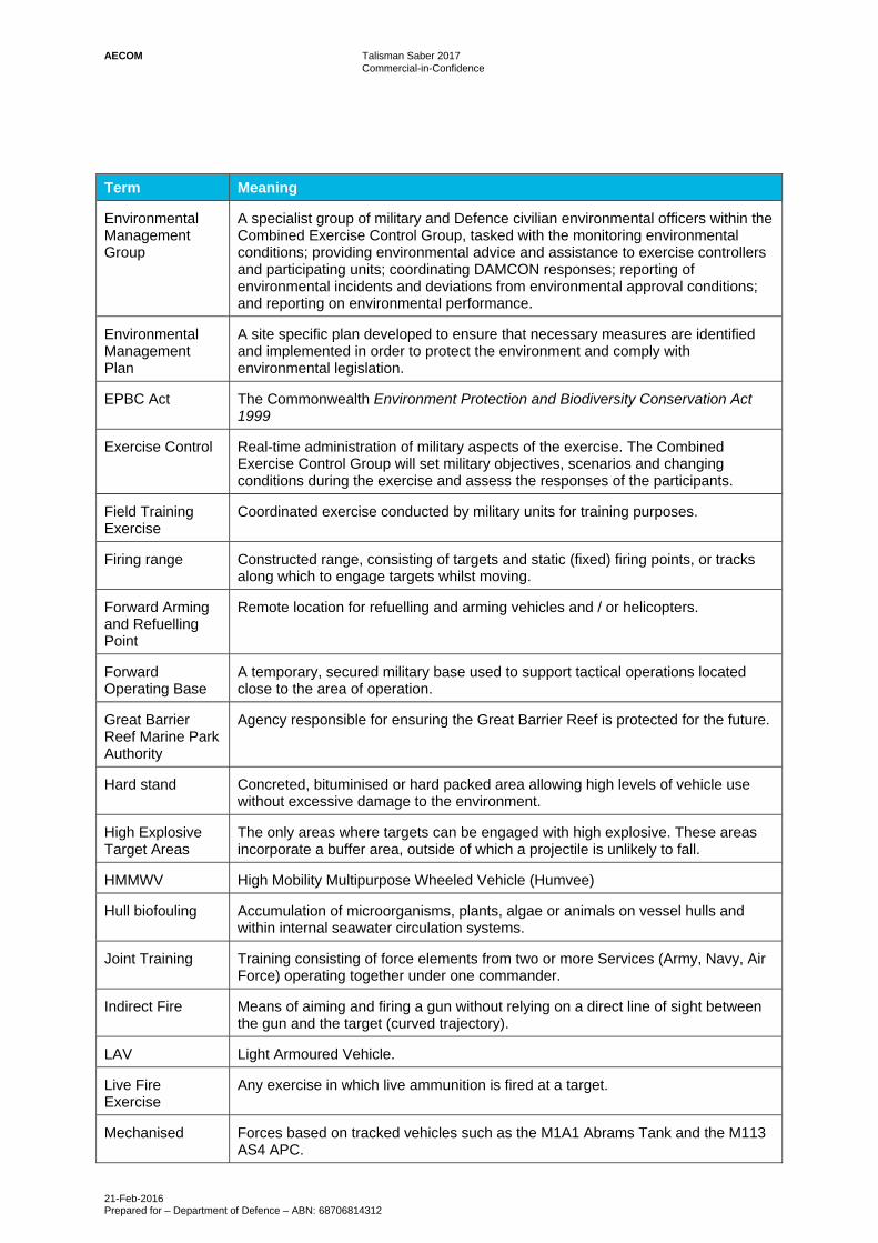
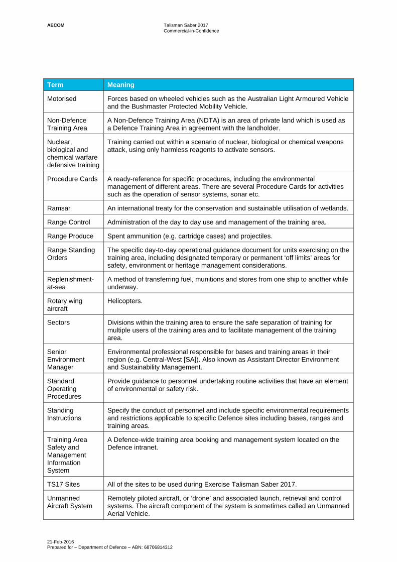
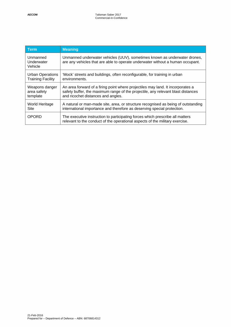
Glossary of Terms
Term Meaning
Army The Australian Army.
Australian Defence Force
The military forces of Australia, comprising the Australian Army, the Royal Australian Air Force and the Royal Australian Navy.
Awareness Cards A pocket reference issued to all personnel before training in certain Training Areas (e.g. Shoalwater Bay Training Area). The cards summarise information on management of environmental issues such as waste, heritage areas, plants and animals, soil, erosion, and fire.
Aqueous Film Forming Foam
Foam used for fire suppression.
A Vehicles Tracked or wheeled armoured vehicles.
B Vehicles Wheeled non-armoured, or lightly armoured vehicles generally used for logistic supply tasks.
Capability Defence’s ability to meet its operational aims and objectives.
Combined Training
Training consisting of military personnel of two or more countries, operating together under one commander.
Commonwealth Commonwealth of Australia.
Coral Sea Marine Reserve
A reserve established and managed under Division 4 of Part 15 of the EPBC Act.
Damage Control Damage Control (DAMCON) is an engineering element responsible for repairing any damage to infrastructure (e.g. road drainage) and the environment during and following the Exercise.
Defence The Department of Defence.
Defence Instructions
The mechanism and authority through which the Chief of the Defence Force, the Secretary for Defence or the Service Chiefs administer the Defence Act as a whole or the Services as single entities.
Direct Fire Means of aiming and firing a gun that relies on a direct line of sight between the gun and the target (flat trajectory).
Dismounted Operating on foot, without use of a vehicle.
Drop zone Flat, cleared area to allow safe parachute deployment.
Electronic Warfare
Warfare involving the use of the electromagnetic spectrum to attack an enemy or protect from enemy attack using the spectrum.
Environmental Clearance Certificate
A mechanism for Defence to identify and manage potential environmental impacts of specific activities and apply appropriate avoidance or mitigation measures as conditions to any approvals given.
AECOM Talisman Saber 2017 Commercial-in-Confidence
21-Feb-2016 Prepared for – Department of Defence – ABN: 68706814312
Term Meaning
Environmental Management Group
A specialist group of military and Defence civilian environmental officers within the Combined Exercise Control Group, tasked with the monitoring environmental conditions; providing environmental advice and assistance to exercise controllers and participating units; coordinating DAMCON responses; reporting of environmental incidents and deviations from environmental approval conditions; and reporting on environmental performance.
Environmental Management Plan
A site specific plan developed to ensure that necessary measures are identified and implemented in order to protect the environment and comply with environmental legislation.
EPBC Act The Commonwealth Environment Protection and Biodiversity Conservation Act 1999
Exercise Control Real-time administration of military aspects of the exercise. The Combined Exercise Control Group will set military objectives, scenarios and changing conditions during the exercise and assess the responses of the participants.
Field Training Exercise
Coordinated exercise conducted by military units for training purposes.
Firing range Constructed range, consisting of targets and static (fixed) firing points, or tracks along which to engage targets whilst moving.
Forward Arming and Refuelling Point
Remote location for refuelling and arming vehicles and / or helicopters.
Forward Operating Base
A temporary, secured military base used to support tactical operations located close to the area of operation.
Great Barrier Reef Marine Park Authority
Agency responsible for ensuring the Great Barrier Reef is protected for the future.
Hard stand Concreted, bituminised or hard packed area allowing high levels of vehicle use without excessive damage to the environment.
High Explosive Target Areas
The only areas where targets can be engaged with high explosive. These areas incorporate a buffer area, outside of which a projectile is unlikely to fall.
HMMWV High Mobility Multipurpose Wheeled Vehicle (Humvee)
Hull biofouling Accumulation of microorganisms, plants, algae or animals on vessel hulls and within internal seawater circulation systems.
Joint Training Training consisting of force elements from two or more Services (Army, Navy, Air Force) operating together under one commander.
Indirect Fire Means of aiming and firing a gun without relying on a direct line of sight between the gun and the target (curved trajectory).
LAV Light Armoured Vehicle.
Live Fire Exercise
Any exercise in which live ammunition is fired at a target.
Mechanised Forces based on tracked vehicles such as the M1A1 Abrams Tank and the M113 AS4 APC.
AECOM Talisman Saber 2017 Commercial-in-Confidence
21-Feb-2016 Prepared for – Department of Defence – ABN: 68706814312
Term Meaning
Motorised Forces based on wheeled vehicles such as the Australian Light Armoured Vehicle and the Bushmaster Protected Mobility Vehicle.
Non-Defence Training Area
A Non-Defence Training Area (NDTA) is an area of private land which is used as a Defence Training Area in agreement with the landholder.
Nuclear, biological and chemical warfare defensive training
Training carried out within a scenario of nuclear, biological or chemical weapons attack, using only harmless reagents to activate sensors.
Procedure Cards A ready-reference for specific procedures, including the environmental management of different areas. There are several Procedure Cards for activities such as the operation of sensor systems, sonar etc.
Ramsar An international treaty for the conservation and sustainable utilisation of wetlands.
Range Control Administration of the day to day use and management of the training area.
Range Produce Spent ammunition (e.g. cartridge cases) and projectiles.
Range Standing Orders
The specific day-to-day operational guidance document for units exercising on the training area, including designated temporary or permanent ‘off limits’ areas for safety, environment or heritage management considerations.
Replenishment-at-sea
A method of transferring fuel, munitions and stores from one ship to another while underway.
Rotary wing aircraft
Helicopters.
Sectors Divisions within the training area to ensure the safe separation of training for multiple users of the training area and to facilitate management of the training area.
Senior Environment Manager
Environmental professional responsible for bases and training areas in their region (e.g. Central-West [SA]). Also known as Assistant Director Environment and Sustainability Management.
Standard Operating Procedures
Provide guidance to personnel undertaking routine activities that have an element of environmental or safety risk.
Standing Instructions
Specify the conduct of personnel and include specific environmental requirements and restrictions applicable to specific Defence sites including bases, ranges and training areas.
Training Area Safety and Management Information System
A Defence-wide training area booking and management system located on the Defence intranet.
TS17 Sites All of the sites to be used during Exercise Talisman Saber 2017.
Unmanned Aircraft System
Remotely piloted aircraft, or ‘drone’ and associated launch, retrieval and control systems. The aircraft component of the system is sometimes called an Unmanned Aerial Vehicle.
AECOM Talisman Saber 2017 Commercial-in-Confidence
21-Feb-2016 Prepared for – Department of Defence – ABN: 68706814312
Term Meaning
Unmanned Underwater Vehicle
Unmanned underwater vehicles (UUV), sometimes known as underwater drones, are any vehicles that are able to operate underwater without a human occupant.
Urban Operations Training Facility
‘Mock’ streets and buildings, often reconfigurable, for training in urban environments.
Weapons danger area safety template
An area forward of a firing point where projectiles may land. It incorporates a safety buffer, the maximum range of the projectile, any relevant blast distances and ricochet distances and angles.
World Heritage Site
A natural or man-made site, area, or structure recognised as being of outstanding international importance and therefore as deserving special protection.
OPORD The executive instruction to participating forces which prescribe all matters relevant to the conduct of the operational aspects of the military exercise.

AECOM Talisman Saber 2017 Commercial-in-Confidence
21-Feb-2016 Prepared for – Department of Defence – ABN: 68706814312
Acronyms AAPA Aboriginal Areas Protection Authority
ADESM Assistant Director Environment and Sustainability Management
ADF Australian Defence Force
AFFF Aqueous Film Forming Foam
AFV Armoured Fighting Vehicle
ASW Anti-Submarine Warfare
BLS Beach Landing Site
CAS Close Air Support
CASEVAC Casualty Evacuation
CBTA Cowley Beach Training Area
CDF Chief of the Defence Force
CECG (Main) Combined Exercise Control Group (Main)
CHL Commonwealth Heritage List
CJOPS Chief of Joint Operations
DAMCON Damage Control
DAWR Department of Agriculture and Water Resources (Commonwealth)
DEIG Defence Estate and Infrastructure Group
DEPA Directorate of Environmental Protection and Assessments
DoEE Department of the Environment and Energy (Commonwealth)
EAR Environmental Assessment Report
ECC Environmental Clearance Certificate
EMG Environmental Management Group
EMP Environmental Management Plan
EMS Environmental Management System
EPBC Act Environment Protection and Biodiversity Conservation Act 1999
EXCON Exercise Control
EXDIR Exercise Director
FARP Forward Arming and Refuelling Point
FEG Force Element Group
FPC Final Planning Conference
GBRMP Great Barrier Reef Marine Park
GBRMPA Great Barrier Reef Marine Park Authority
GBRWHA Great Barrier Reef World Heritage Area
HBTA Halifax Bay Training Area
HEMP Heritage Environment Management Plan
ILUA Indigenous Land Use Agreement
LAT Lowest Astronomical Tide
LCAC Landing Craft Air Cushion

AECOM Talisman Saber 2017 Commercial-in-Confidence
21-Feb-2016 Prepared for – Department of Defence – ABN: 68706814312
MBTA Mount Bundey Training Area
MNES Matters of National Environmental Significance
MOU Memorandum of Understanding
MPC Mid-Planning Conference
NDTA Non-Defence Training Area
NOTAM Notice to Airmen
NOTMAR Notice to Mariners
NM Nautical Miles
NSW New South Wales
NT Northern Territory
NZ New Zealand
OCE Officer Conducting the Exercise
PER Public Environment Report
PMST Protected Matters Search Tool
QLD Queensland
RAAF Royal Australian Air Force
RAN Royal Australian Navy
RAS Replenishment-at-Sea
RESO Regional Environment and Sustainability Officer
RSO Range Standing Order
RSO&I Reception, Staging, Onward Movement and Integration
SBL Small Beach Landing Site
SI Standing Instruction
SEVT Semi-evergreen vine thickets of the Brigalow Belt (North and South) and Nandewar Bioregions
SIG 1.1 Significant Impact Guidelines 1.1 Matters of National Environmental Significance
SIG 1.2 Significant Impact Guidelines 1.2 Actions on, or impacting upon, Commonwealth land, and actions by Commonwealth agencies
SOF Special Operations Forces
SOP Standard Operating Procedure
SO Standing Order
SOVO Standing Order for Vehicle Operators
SMRP Sustainability Monitoring and Reporting Plan
SWBTA Shoalwater Bay Training Area
TFTA Townsville Field Training Area
TS11 Talisman Sabre 2011
TS13 Talisman Saber 2013
TS15 Talisman Sabre 2015
TS17 Talisman Saber 2017
UOTF Urban Operations Training Facilities

AECOM Talisman Saber 2017 Commercial-in-Confidence
21-Feb-2016 Prepared for – Department of Defence – ABN: 68706814312
US United States
US Forces United States Armed Forces
USMC United States Marine Corps
USN United States Navy
WHA World Heritage Area
WHS Work Health & Safety
AECOM Talisman Saber 2017 Commercial-in-Confidence
21-Feb-2016 Prepared for – Department of Defence – ABN: 68706814312
I
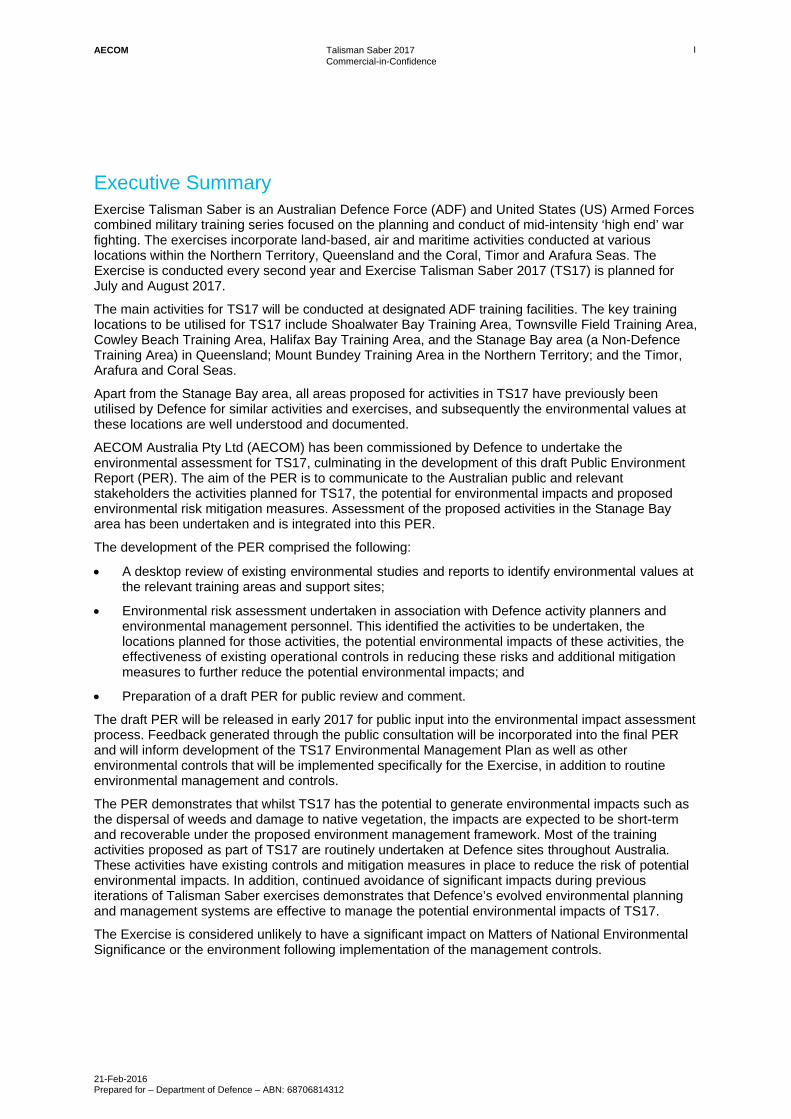
Executive Summary Exercise Talisman Saber is an Australian Defence Force (ADF) and United States (US) Armed Forces combined military training series focused on the planning and conduct of mid-intensity ‘high end’ war fighting. The exercises incorporate land-based, air and maritime activities conducted at various locations within the Northern Territory, Queensland and the Coral, Timor and Arafura Seas. The Exercise is conducted every second year and Exercise Talisman Saber 2017 (TS17) is planned for July and August 2017.
The main activities for TS17 will be conducted at designated ADF training facilities. The key training locations to be utilised for TS17 include Shoalwater Bay Training Area, Townsville Field Training Area, Cowley Beach Training Area, Halifax Bay Training Area, and the Stanage Bay area (a Non-Defence Training Area) in Queensland; Mount Bundey Training Area in the Northern Territory; and the Timor, Arafura and Coral Seas.
Apart from the Stanage Bay area, all areas proposed for activities in TS17 have previously been utilised by Defence for similar activities and exercises, and subsequently the environmental values at these locations are well understood and documented.
AECOM Australia Pty Ltd (AECOM) has been commissioned by Defence to undertake the environmental assessment for TS17, culminating in the development of this draft Public Environment Report (PER). The aim of the PER is to communicate to the Australian public and relevant stakeholders the activities planned for TS17, the potential for environmental impacts and proposed environmental risk mitigation measures. Assessment of the proposed activities in the Stanage Bay area has been undertaken and is integrated into this PER.
The development of the PER comprised the following:
A desktop review of existing environmental studies and reports to identify environmental values at the relevant training areas and support sites;
Environmental risk assessment undertaken in association with Defence activity planners and environmental management personnel. This identified the activities to be undertaken, the locations planned for those activities, the potential environmental impacts of these activities, the effectiveness of existing operational controls in reducing these risks and additional mitigation measures to further reduce the potential environmental impacts; and
Preparation of a draft PER for public review and comment.
The draft PER will be released in early 2017 for public input into the environmental impact assessment process. Feedback generated through the public consultation will be incorporated into the final PER and will inform development of the TS17 Environmental Management Plan as well as other environmental controls that will be implemented specifically for the Exercise, in addition to routine environmental management and controls.
The PER demonstrates that whilst TS17 has the potential to generate environmental impacts such as the dispersal of weeds and damage to native vegetation, the impacts are expected to be short-term and recoverable under the proposed environment management framework. Most of the training activities proposed as part of TS17 are routinely undertaken at Defence sites throughout Australia. These activities have existing controls and mitigation measures in place to reduce the risk of potential environmental impacts. In addition, continued avoidance of significant impacts during previous iterations of Talisman Saber exercises demonstrates that Defence’s evolved environmental planning and management systems are effective to manage the potential environmental impacts of TS17.
The Exercise is considered unlikely to have a significant impact on Matters of National Environmental Significance or the environment following implementation of the management controls.
AECOM Talisman Saber 2017 Commercial-in-Confidence
21-Feb-2016 Prepared for – Department of Defence – ABN: 68706814312
1
1.0 Introduction
1.1 Background and objectives of Exercise TS17
The Talisman Saber series of exercises is a major ADF and US Armed Forces joint and combined military training exercise focused on developing interoperability between forces, achieving critical proficiency qualifications and enabling high-end war fighting field training activities to take place under a fictional scenario. The Exercise incorporates maritime, air, and land-based elements and is conducted at various locations within Queensland (Qld), the Northern Territory (NT) and adjacent maritime areas. The principal participants are Australian and US armed forces comprising the Royal Australian Navy (RAN), United States Navy (USN), United States Marine Corps (USMC), Royal Australian Air Force (RAAF), United States Air Force (USAF), Australian Army and United States Army (US Army). Elements of New Zealand (NZ), Canadian, and Japanese armed forces may also participate.
Talisman Saber has taken place every two years since 2005 and joint combined Australian and US exercises of similar scale, locations and objectives have been carried out since 1997 as Exercise Crocodile and Exercise Tandem Thrust. Talisman Saber typically involves up to 30,000 Australian and US participants, with the majority of participants afloat or offshore. The Exercise is designed primarily to maximise collective training benefits within a Combined Task Force setting, and to expose participants to a wide spectrum of military capabilities and training experiences, including live fire opportunities.
Exercise Talisman Saber 2017 (TS17 or ‘the Exercise’) is expected to incorporate Reception, Staging, Onward movement and Integration (RSO&I), Special Operations Forces (SOF) activities, amphibious landings, parachute drops, land force manoeuvre, urban operations, air operations, electronic warfare and the coordinated firing of ammunition and explosive ordnance (both live and inert) from small arms, artillery, naval vessels, and aircraft. Maritime activities may also include use of sonobuoys, mine-clearing, replenishment-at-sea, Unmanned Surface Vessels (USVs), Unmanned Underwater Vessels (UUVs), simulated mine clearing, and anti-submarine warfare.
AECOM Australia Pty Ltd (AECOM) has been commissioned by Defence to provide environmental support for the Exercise including environmental assessment and development of this PER and an Environmental Management Plan (EMP). The aim of this PER is to communicate to the Australian public and relevant stakeholders the activities planned for TS17, potential environmental impacts and the measures that will be implemented to mitigate these impacts.
1.2 Justification for the Exercise
The Talisman Saber series of exercises is of critical importance to maintain and enhance ADF capability, readiness and interoperability between services and forces. As well as providing high-end war fighting training, it enables certification for numerous competencies required for deployment.
TS17 builds upon past and present joint and combined operations with the US such as Operation Inherent Resolve in Syria and Iraq as well as Talisman Saber Exercises carried out since 2005. TS17 is therefore essential to support the ADF’s primary mission to defend Australia and its national interests as well as contributing significantly to regional and global security.
1.3 Operational and Environmental Management Context
Defence operates and maintains several large training areas across the country. Each has a unique set of attributes that support the development and maintenance of specific operational capabilities under the full range of environmental conditions that the ADF may be called upon to operate within. These attributes may relate to environmental extremes (e.g. hot, cold, tropical or arid), terrain (e.g. mountainous, dense, open or coastal) and sufficient size to safely support certain capabilities and weapon systems (e.g. brigade-level mechanised manoeuvre, air-delivered high explosive ordnance). In some cases, particularly with new or recently enhanced capabilities, the training area estate does not possess sufficient elements to develop a capability to its full potential.
AECOM Talisman Saber 2017 Commercial-in-Confidence
21-Feb-2016 Prepared for – Department of Defence – ABN: 68706814312
2
In these cases, areas of public and / or private land may be temporarily designated as a non-Defence Training Area (NDTA) for a specific exercise as agreed with the landholder. This will occur during TS17 when an amphibious landing activity is planned to take place at Stanage Bay to the north of Shoalwater Bay Training Area (SWBTA). The Amphibious Ready Element (ARE) is an emerging ADF capability centred upon the recent acquisition of Navy’s Landing Helicopter Dock (LHD) ships. Developing this capability will support ADF operations involving larger scale amphibious landings, including humanitarian assistance such as the recent Operation Fiji Assist as well as more broadly contributing to regional and global stability. While SWBTA is able to support amphibious landing, its attributes are such that it is insufficient to support the scale of beach landing activities proposed for TS17 due to bathymetric and tidal factors, as well as beach access constraints.
Defence training areas, maintained in a sustainable condition that supports functioning natural ecosystems, is critical to Defence capability. A range of operational controls and other measures are employed to ensure that risks to this capability are managed. For example, excluding grassy weeds from a training area reduces its flammability, which in turn maintains vegetation structure and minimises erosion potential. To mitigate these risks, Defence operates vehicle wash-points and all vehicles must be assessed as clean and weed-free prior to entering any training area. Additionally, existing weed infestations are subject to ongoing management which may include a control program and its demarcation as a restricted area. Through approaches such as this, maintenance of critical training area attributes is closely linked to the maintenance of ecosystem function, biodiversity and heritage values that are subject to similar threatening processes. Where an activity is non-routine in its nature, scale or location, it is assessed in terms of environmental compliance and risk, and where any such risks are not adequately covered by routine measures, activity-specific controls are implemented (see Section 4.5). For the Stanage Bay area, as this is not Defence land, activities on this land are managed through Standing Orders (SOs) for NDTAs and through Exercise controls (EXCON) incorporating findings from the Stanage Bay Environmental Report for the activity which is provided in Attachment 1- Stanage Bay Environmental Report.
Due to its inherent command structure, Defence is able to consistently employ measures which would be difficult or impossible to implement on public lands due to the requirement to facilitate a range of recreational pursuits as well as practical constraints in enforcing certain environmental measures. Defence training areas, many of which have been managed by Defence for decades, often contrast markedly with surrounding areas as the long-term land use and management as a training area result in the preservation of unique environment and heritage values that might have otherwise have been lost. Combined with the environmental assessment and management processes Defence has in place, Defence training areas will be able to continue to support Defence training activities as well as environment and heritage values well into the future.
1.4 Locations
Field Training Exercises (FTX) incorporating Live Firing Exercises (LFX) will be conducted in the Northern Territory (FTX-North) and Queensland (FTX-East), specifically at Mount Bundey Training Area (MBTA), SWBTA, Townsville Field Training Area (TFTA), Halifax Bay Training Area (HBTA), and Cowley Beach Training Area (CBTA). An amphibious landing component is planned to be carried out on public and private land at Stanage Bay (herein referred to as the Stanage Bay Area). Maritime activities will take place within the Arafura, Timor and Coral Seas, including waters within the Great Barrier Reef Marine Park (GBRMP) and in the vicinity of and approaches to TFTA, CBTA, HBTA and SWBTA. Support establishments, which will be used for RSO&I and Exercise administration include:
Port facilities in Qld and NT - primarily Darwin, Gladstone, and Townsville;
RAAF Bases at Darwin, Tindal, Townsville, and Amberley;
Rockhampton Airport;
Defence accommodation at Darwin (Robertson Barracks and Larrakeyah Barracks) andRockhampton (Camp Rocky);
Minor training areas to support out-of-exercise ancillary practice comprising Robertson Barracks CloseTraining Area and Kangaroo Flats Training Area (KFTA); and
Defence administration facilities in Canberra.

AECOM Talisman Saber 2017 Commercial-in-Confidence
21-Feb-2016 Prepared for – Department of Defence – ABN: 68706814312
3
The training areas and maritime areas that will support the Exercise are briefly described below in Table 1 and Table 2 respectively and are hereafter referred to as ‘the TS17 sites’. Figure 1 shows the general locality for training and support activities.
Table 1 Exercise Training Areas
Training area Description
Queensland (FTX-E)
Shoalwater Bay Training Area (SWBTA)
SWBTA is approximately 454,500ha with its southern boundary located 50km north of Rockhampton and its gazetted area comprising land, coastal and sea environments. The maritime portion of SWBTA is within the GBRMP. SWBTA terrain comprises subtropical savannah, rainforest, vine thickets, wetlands, mangroves, relic dune systems, floodplains, offshore islands and reefs.
Townsville Field Training Area (TFTA)
TFTA is approximately 208,000ha and is located 50km southwest of Townsville. It is bounded to the north and east by escarpments of the Paluma and Herveys Ranges, while the western boundary lies west of Star River. TFTA comprises rivers and associated floodplains, with the majority of vegetation consisting of open savannah woodland.
Cowley Beach Training Area (CBTA)
CBTA is 5,081ha and is located in the wet tropics region on the north Qld coast, immediately north of the township of Inarlinga and approximately 40km south of Innisfail. It comprises both land, coastal and sea environments including 8km of beaches and the immediate hinterland. The maritime portion includes Lindquist Island located approximately 1km offshore.
Halifax Bay Training Area (HBTA)
HBTA is located in the GBRMP, 25km north west of Townsville and 14km off the coast. HBTA is made up of Rattlesnake Island, Acheron Island, Herald Island, Cordelia Rocks and Bramble Rocks. The islands are mostly coastal scrub with high steep features dominating all the islands.
The Stanage Bay area (Non-Defence Training Area)
The Stanage Bay area is 3,325ha and extends from the Stanage Bay locality on the tip of the Torilla Peninsula, south to the boundary of SWBTA, including adjacent waters. The Stanage Bay area comprises similar terrain to the coastal portions of SWBTA but with the addition of areas of cleared land.
Northern Territory (FTX-North)
Mount Bundey Training Area (MBTA)
MBTA is approximately 117,300ha and is located 115km south east of Darwin. It is bounded by the Arnhem Highway to the north, Mary River and the proposed Mary River National Park to the west, and Kakadu National Park to the east and south. MBTA terrain primarily consists of a large floodplain on the Mary River, adjacent rocky uplands and tropical savannah.

AECOM Talisman Saber 2017 Commercial-in-Confidence
21-Feb-2016 Prepared for – Department of Defence – ABN: 68706814312
4
Table 2 Exercise Maritime areas
Maritime area
Description
Timor Sea The Timor Sea is bordered by Timor Leste, the Indian Ocean, the north coast of the NT and Western Australia and Arafura Sea.
Arafura Sea The Arafura Sea is bordered by the Banda and Ceram seas, Timor Sea, the north coast of the NT, the Gulf of Carpentaria, Cape York, Torres Strait, New Guinea and the Papua and West Papua provinces of Indonesia.
Coral Sea The Coral Sea is bordered by the east coast of Qld (including the Great Barrier Reef), New Caledonia, the Solomon Islands, New Guinea and the Torres Strait.

") ")
")
")
")
")
")
")
")
")
")
GF
!!
!
!
!
!
!
!
!
RAAF Base Amberley
Arafura Sea
Coral SeaINDIAN OCEAN
INDIAN OCEAN
PACIFIC OCEAN
Gulf of Carpentaria
Timor Sea
Tasman Sea
Cowley Beach Training Area
RAAF Townsville
Saumarez ReefsTownsville FieldTraining Area
Stanage BayShoalwater Bay Training Area
Kangaroo FlatsTraining Area
RAAF BaseTindal
Mount BundeyTraining Area
RAAF Base DarwinDarwin Showgrounds
Halifax Bay AirWeapons Range
CANBERRA
SYDNEY
BRISBANE
MELBOURNE
HOBART
PERTH
DARWIN
ADELAIDE
New South Wales
Northern Territory
Queensland
South Australia
Victoria
Western Australia
Tasmania
K
A3 sizeAECO
M does
not w
arrant
the ac
curacy
or com
pleten
ess of
informa
tion dis
played
in this
map a
nd any
perso
n usin
g it do
es so
at thei
r own ri
sk. A
ECOM
shall
bear no
respon
sibility
or liab
ility for
any e
rrors,
faults,
defec
ts, or o
missio
ns in t
he info
rmation
.
Legend") Exercise LocationGF Saumarez Reefs! City
State BoundaryExclusive Economic Zone
GEOGRAPHIC DATUM AUSTRALIA 1994
Figure1
Document Path: O:\Bus_Lines\WIS\Team - T&DS\1_Business_Development\DEFENCE\Talisman\MXD\PER\Figure1_PER_GenLoc.mxd
GENERAL LOCALITY OF TRAINING AND SUPPORTACTIVITIES FOR TS17
Data Sources:1. Locality, Roads © StreetPro 20112. Base Map @ Esri, USGS, NOAA3. Exclusive Economic Zone Seas and Submerged Lands Act 1973 Proclamation under section 10B (26/07/1994)AMB2014a - Area @ Commonwealth of Australia (Geoscience Australia) 2014-01-01
Disclaimer:StreetPro © 2011 Pitney Bowes Software Pty Ltd. All rights reserved© State of Queensland (Department of Natural Resources and Mines) 2014. Data from Commonwealth of Australia(Geoscience Australia) 2009 used in creating this dataset provided under Creative Commons Australia - Attributionlicence.Updated data available at http://dds.information.qld.gov.au/dds/
© The State of Queensland (Department of Environment and Resource Management) 2011. While every care is takento ensure the accuracy of the Information Product, the Department of Environment and Resource Management makesno representations or warranties about its accuracy, reliability, completeness or suitability for any particular purposeand disclaims all responsibility and all liability (including without limitation, liability in negligence) for all expenses,losses, damages (including indirect or consequential damage) and costs which you might incur as a result of theproduct being inaccurate or incomplete in any way and for any reason.
PROJECT #:
LAST MODIFIED:CREATED BY:
60517266BM
VERSION: 1BM: 14/12/2016
Talisman Saber 2017Public Environmental Report
0 200 400 600Kilometres
")")
")
")
")
")
")")
")
")")
QLD
NSWSA
NT
WA
TAS
AECOM Talisman Saber 2017 Commercial-in-Confidence
21-Feb-2016 Prepared for – Department of Defence – ABN: 68706814312
6
1.5 Environmental assessment background
Defence is following a PER process to identify and mitigate potential impacts, invite public comment and obtain input into the environmental management of the Exercise. This PER has been prepared by AECOM with input from Defence Exercise planning and environmental professional staff. The Great Barrier Reef Marine Park Authority (GBRMPA) was also consulted during the process.
Mitigation actions developed through the PER process will be promulgated through the overall Exercise plan and will be implemented through the Combined Exercise Instruction (CEI) as well as through activity-specific Environmental Clearance Certificates (ECCs) and relevant environmental awareness and guidance documentation. Environmental support during the Exercise will be provided by an Environmental Management Group (EMG) established for the duration of the Exercise.
This approach has proven effective previously in managing environmental issues, as well as for engaging with key stakeholders and the general public regarding planned activities. It has been continuously improved and refined from the lessons identified from earlier major exercises conducted in Australia since 2005.
1.6 TS17 status and timeframe
The Exercise is planned to start on or around 15 June 2017 with establishment of the Combined Exercise Control Group (Main) [CECG Main], however in-exercise field activities are not expected to commence until 21 June 2017 with the establishment of opposing force (OPFOR) elements marking the start of the training scenario. FTX-North is planned to run from 21 June – 7 July 2017 and FTX-East from 8 July - 25 July 2017. Additionally, deployment and redeployment of platforms, weapons, support materiel and personnel will occur in the two weeks prior to and following the start and end of the Exercise
1.7 PER objectives
The PER provides the public, stakeholders and Defence environmental managers with information to understand the nature of activities proposed for TS17, their locations, the potential environmental impacts and the mitigation measures that will be implemented to avoid or minimise impacts.
The objectives of the PER are to:
Identify and assess the potential environmental impacts of TS17 activities – this includes the potential for significant impacts on Matters of National Environmental Significance (MNES) under the Environment Protection and Biodiversity Conservation Act 1999 (EPBC Act), as well as ‘the environment’ more broadly as defined in Section 528 of the EPBC Act;
Identify the environmental controls and mitigation measures to be implemented to avoid or minimise the risk of environmental impacts arising; and
Communicate the Exercise and associated mitigation actions to the Australian public and stakeholders and gather feedback to enable continuous improvement of the environmental management of the Exercise.
1.8 Community and stakeholder consultation
An integral component of TS17 is consultation with the community and stakeholders on potential environmental impacts associated with the Exercise and the proposed environmental management measures to address these. Information on TS17 will be provided through a range of community and stakeholder engagement activities including meetings with key stakeholders, community and stakeholder information sessions, advertisements in local and state / territory newspapers, provision of information via fact sheets, a dedicated website, social media, a dedicated email address, a free-call number for queries, and library displays throughout the entire consultation period. The public consultation period on the draft TS17 PER will be undertaken from February to March 2017.
Following the public consultation period, a final PER will be produced and released to the public. Further information on the consultation program is provided in Section 7.7 of the PER.

AECOM Talisman Saber 2017 Commercial-in-Confidence
21-Feb-2016 Prepared for – Department of Defence – ABN: 68706814312
7
1.9 PER structure
The PER is structured in accordance with Schedule 4 of the Environment Protection and Biodiversity Conservation Regulations 2000 (as amended, latest version October 2016) as follows:
Section 2.0 describes the method used to determine the environmental values, risks, impacts and mitigation measures of the Exercise;
Section 3.0 describes the TS17 Exercise, including planned timing, activities to be undertaken at each location, and weapons and equipment to be used;
Section 4.0 presents the legislative context of the Exercise as well as Defence policies and guidelines that are in place to ensure sustainable environmental management at Defence training areas and for Defence exercises;
Section 5.0 presents a description of the existing values at each of the proposed TS17 locations;
Section 6.0 presents the risk-based evaluation of potential impacts without mitigation and the residual risk assessment when Exercise-specific controls have been implemented;
Section 7.0 describes the standard Defence environmental impact mitigation measures and the TS17 specific operational controls;
Section 8.0 presents the significant impact analysis for impacts on MNES, as well as impacts on the whole of the environment on Commonwealth land or actions taken by a Commonwealth agency;
Section 9.0 considers the EPBC Permit requirements;
Section 10.0 provides a conclusion including a summary and recommendations for the Exercise; and
Section 11.0 provides the References used in this PER.

AECOM Talisman Saber 2017 Commercial-in-Confidence
21-Feb-2016 Prepared for – Department of Defence – ABN: 68706814312
8
2.0 Methods
2.1 General approach
The development of this PER and associated environmental impact assessment process comprised the following:
A desktop review of existing environmental studies and reports in order to identify environmental values at the relevant training areas and support sites;
Attendance at the Talisman Saber Mid-Planning Conference (MPC) in order to understand the planned nature and locations of key Exercise activities;
Development of a risk assessment to assess the planned activities and the effectiveness of existing operational and additional controls in reducing the risk of potential impacts;
Development of mitigation measures to reduce the risk of impact to MNES and the environment as a whole whilst maintaining required Exercise outcomes;
Preparation of a Significant Impact Analysis (SIA) in accordance with the Significant Impact Guidelines 1.1 Matters of National Environmental Significance (SIG 1.1) (Department of Environment and Energy (DoEE) then DoE, 2013) and Significant Impact Guidelines 1.2 Actions on, or impacting upon, Commonwealth land, and actions by Commonwealth agencies (SIG 1.2) (DoEE then DSEWPaC, 2013). This provided an assessment of the likely impacts of the action on protected matters under the EPBC Act; and
Preparation of a draft PER for public comment (this document).
In February 2017, the public consultation phase will commence (refer to Section 7.7). Public submissions will be reviewed, addressed and incorporated into the final PER. The final PER will be assessed by the Directorate of Environmental Protection and Assessments (DEPA) within the Defence Estate and Infrastructure Group (DEIG) to ensure that Defence continues to meet its environmental obligations in conducting the Exercise
Following finalisation of the PER and related environmental management documentation, the environmental impact management process will be completed through:
Integration of environmental mitigations actions and constraints into Exercise Environmental Management Plans at the Talisman Saber Final Planning Conference (FPC) by Australian and US Exercise Planners;
Preparation of an Environmental Assessment Report (EAR) by DEPA (EPBC Act self-assessment report);
Assessment and approval of ECCs prepared by participating units and approved by the Regional Environment and Sustainability Officers (RESO) for the relevant site/s;
Environmental awareness briefings and provision of environmental planning and awareness materials to Exercise participants;
Environmental monitoring during the Exercise by the EMG; and
Preparation of an environmental post-Exercise report to review the environmental outcomes of the Exercise and facilitate continuous improvement.
Flora and fauna review methods 2.1.1
Methods specific to identifying flora and fauna values and assessing potential impacts are described below and the results are provided in Section 5.0.
2.1.1.1 Database searches
Desktop assessments were conducted using the DoEE’s Protected Matters Search Tool (PMST) to identify protected flora and fauna species with potential to occur within or surrounding the TS17 sites. For each search, a 10 km buffer was applied to the search area in accordance with Defence’s Guidance on the Preparation of an Environmental Report (Department of Defence, 2013).
AECOM Talisman Saber 2017 Commercial-in-Confidence
21-Feb-2016 Prepared for – Department of Defence – ABN: 68706814312
9
The coordinates used for the PMST searches and the PMST results are provided as follows:
SWBTA: see Appendix F (search conducted on 18 October 2016);
TFTA: see Appendix G (search conducted on 21 October 2016);
CBTA: see Appendix H (search conducted on 21 October 2016);
MBTA: see Appendix I (search conducted on 24 October 2016);
HBTA: see Appendix J (search conducted on 07 November 2016);
Stanage Bay area: see Appendix K (search conducted on 8 September 2016);
Timor & Arafura Seas: see Appendix L (search conducted on 31 October 2016); and
Coral Sea: see Appendix M (search conducted on 31 October 2016).
The following databases were also accessed to identify records of State and Territory listed flora and fauna species:
The Qld Department of Environment and Heritage Protection (DEHP) ‘Wildlife Online’ database was used to identify endangered, vulnerable and near threatened (EVNT) species within each of Qld sites (accessed on 20 October 2016 for SWBTA and 21 October for TFTA and CBTA);
Regulated Vegetation Management Maps (including essential habitat) from the Qld Vegetation Management Act 1999 (VM Act), were used to identify potential habitat for EVNT species at Qld sites;
The Northern Territory Natural Resource Management ‘InfoNet’ database was used to identify EVNT species at NT sites (accessed on 23 October 2016); and
The Atlas of Living Australia was used to identify further records of EVNT flora and fauna species occurring within Qld and NT sites (accessed on 20 October 2016 for SWBTA and 21 October for TFTA and CBTA).
2.1.1.2 Literature review
References reviewed to develop the PER are provided in the Reference section, Section 11.0.
The focus of the ER is on impacts to MNES and the environment more broadly. Impacts to State listed flora and fauna species and habitat have been considered under the ‘Whole of the Environment’ sections of the report (Section 5.0 for values, Section 8.2 for the Significant Impact tests).
Species listed as Marine or Cetacean under the EPBC Act are only MNES where they occur in Commonwealth waters (3 – 200 nautical miles (NM) from the coast of the mainland and of offshore islands), or are otherwise protected as threatened or migratory species of MNES. The Significant Impact tests for these species are summarised in Section 8.1.4 and Section 8.1.6, which present the Significant Impact Assessment.
2.1.1.3 Likelihood of Occurrence
A ‘likelihood of occurrence’ rating was assigned to species that were identified as having the potential to occur at the sites proposed for TS17. For species only listed as either marine or cetacean, the likelihood of occurrence was only assessed in Commonwealth Marine waters as, unless otherwise listed, these species are only MNES where they occur in Commonwealth Marine waters. These ratings are provided in Appendix N and have been determined using a combination of factors including:
1. PMST Likelihood of Occurrence ratings;
2. Records of species presence at the site or within the general vicinity of the site, obtained from the Atlas of Living Australia;
3. Information contained on the Species Profile and Threats Database; and
4. Previous reports for the relevant training areas and support sites.
The definitions used to determine likelihood of occurrence for species are provided in Table 3 below are from the Defence Environment Risk Tool (DERT) (see Appendix B):

AECOM Talisman Saber 2017 Commercial-in-Confidence
21-Feb-2016 Prepared for – Department of Defence – ABN: 68706814312
10
Table 3 Likelihood of occurrence definitions for MNES species
Likelihood of occurrence rating
Definition*
Almost Certain Has occurred several times in the past year and in each of the previous 5 years OR has a > 90% chance of occurring if the risk is not mitigated.
E.g. Species directly observed on the site or recorded at the site within the past ten years. Preferred habitat is present on the site.
High Has occurred at least once in the past year and in each of the previous 5 years OR has a 60-90% chance of occurring before the risk assessment is reviewed (12 months) if the risk is not mitigated.
E.g. Species has been recorded on site. The site contains significant preferred habitat which is likely to support a population of the species, including roost sites.
Moderate Even probability of consequences occurring before the risk assessment is reviewed (12 months). Has occurred two or three times during the past 5 years OR has a 40-60% chance of occurring before the risk assessment is reviewed (12 months) if the risk is not mitigated.
E.g. Site contains some of the preferred habitat to support a population of the species and the species has been recorded within the vicinity of the site.
Low Has occurred once in the last 5 years OR has a 10-30% chance of occurring in the future if the risk is not mitigated.
E.g. Some of the preferred habitat present on the site. Species may infrequently visit the site en-route for foraging but will not roost or otherwise depend on habitats on the site for their survival. Migratory and aerial foraging birds may overfly the site.
Unlikely Has not occurred in the past 5 years OR may occur in exceptional circumstances (i.e. less than 10% chance of occurring in the next funding period if the risk is not mitigated).
E.g. The species has no recent historical records, and has no preferred habitat on the site and is considered unlikely to be present on the site.
* From the Defence Environment Risk Tool
Heritage review methods 2.1.2
Methods specific to identifying potential heritage values and assessing potential impacts are described below and the results are provided in Section 5.0.
2.1.2.1 Database searches
The PMST searches were also used to identify heritage-related MNES (e.g. Commonwealth and National Heritage Places) occurring at or near the TS17 sites. Searches were also undertaken of the:
Australian Heritage Database;
Australian National Shipwreck Database;
NT Heritage Register;
Aboriginal Areas Protection Authority (AAPA) Sacred Sites Register;
Qld Aboriginal & Torres Strait Islander Cultural Heritage Register;
Qld State Heritage Register;
Qld Cultural Heritage Information Management System;

AECOM Talisman Saber 2017 Commercial-in-Confidence
21-Feb-2016 Prepared for – Department of Defence – ABN: 68706814312
11
Qld WW2 Heritage Places; and
Australian Monuments Database.
2.1.2.2 Literature review
References reviewed to develop the PER are provided in the Reference section, Section 11.0.
2.2 Environmental Risk Assessment
A Joint Statement of Principles between the Australian and the US Armed Forces commits the forces to consider environmental impacts at the earliest stage of planning activities as an integrated element of risk assessment, and to strive to develop and implement measures to mitigate such impacts. An environmental risk assessment has been completed for TS17 as part of the PER process (see Section 6.0). The risk assessment process that was followed is consistent with the principles of the AS/NZ ISO 31000:2009 (ISO 31000) Risk Management – Principles and Guidelines (Standards Australia / New Zealand, 2009) and is described below:
i. Initial Environmental Risk Assessment: This was carried out in a workshop held during the Initial Planning Conference (17 – 29 June, 2016). The workshop was attended by representatives from Defence (Headquarters Joint Operations Command, RAN, DEIG (including DEPA), U.S. Armed Forces (Navy, Army and Marine Corps), and GBRMPA.
a. Planned activities were assessed according to their potential impacts on the environment at the sites at which the activities were planned to be undertaken;
b. Standard Defence environmental controls were identified (see Section 4.5and Appendix E) which were relevant to the activities and the potential impacts; and
c. An initial risk rating was determined taking into account standard controls (see Section 6.1).
ii. Risk Assessment review and incorporation into PER: AECOM reviewed the risk assessment as part of the PER and identified issues requiring closer consideration in the PER.
a. Environmental values and potential impacts from the Initial Risk Assessment were considered based on information sources including:
- Outcomes from previous Talisman Saber Exercises (PERs and Post-Exercise Reports (PXRs));
- Previous environmental monitoring, PMST searches, and field survey data for training areas;
- Strategic Environmental Assessment of Defence Activities in the Great Barrier Reef World Heritage Area (GBRWHA) (PGM Environment & Ecological, 2014);
- GBRMPA Strategic Assessment; and
- Reef 2050 Reports:
Long-Term Sustainability Plan;
Policy Guideline for Decision Makers;
Update on Progress;
Annual Report and Implementation Strategy 2016;
Investment Framework; and
Investment Baseline.
b. Risks with a rating of ‘Medium’ or ‘High’ were considered in further detail;
c. Additional mitigation measures were identified to reduce the likelihood and / or consequence of these risks (see Section 7.2); and
d. The risks were then reassessed to determine the residual risk of the activity with additional controls implemented to confirm that potential impacts would be sufficiently controlled (see Section 6.2).

AECOM Talisman Saber 2017 Commercial-in-Confidence
21-Feb-2016 Prepared for – Department of Defence – ABN: 68706814312
12
iii. Risk Ratings
a. To attain the risk rating for both the initial and residual risks, the likelihood of an event occurring was combined with the potential consequences of an event, as stated in ISO31000 and in the Defence Environmental Risk Tool (DERT) (see Appendix A); and
b. The likelihood and consequence were determined based on the guiding descriptors in the DERT.
iv. Risk Measures
a. All risks were assessed in terms of impacts to environment and heritage values; and
b. The risk assessment also considered potential impacts to capability, legislative compliance, financial outputs, Work Health & Safety (WHS), personnel and reputation for some of the risks that were identified.
The results of the risk assessment can be found in Section 6.0.
2.3 EPBC Act Significance Test
An EPBC Act Significant Impact test was undertaken which took into account both the standard control measures and the additional mitigation measures. The significance tests were completed in accordance with the EPBC Act SIG 1.1, SIG 1.2, the Draft significant impact guidelines for 36 migratory shorebird species (DoEE then DEWHA, 2009) and the Guidance on the preparation of an Environmental Report (Department of Defence, 2013). The results can be found in Section 8.0.

AECOM Talisman Saber 2017 Commercial-in-Confidence
21-Feb-2016 Prepared for – Department of Defence – ABN: 68706814312
13
3.0 Description of Exercise TS17
3.1 Exercise objectives
TS17 will form an essential part of the ADF’s training program as it will certify troops for deployment, provide invaluable experience to ADF personnel and enhance the ADF’s capability to provide and contribute to regional security. The primary aim of Exercise TS17 is to improve training and interoperability between the Australian and US Armed Forces at the operational and tactical level.
The Exercise is designed primarily to maximise combined training benefits within a Combined Task Force setting, and to expose participants to a wide spectrum of military capabilities and training experiences, including a variety of live fire opportunities.
3.2 Participants
TS17 is expected to involve approximately 33,000 participants from the Australian and US military forces, with some elements from the NZ, Canadian and Japanese armed forces, spread throughout a range of training environments in Australia and overseas. As shown in Figure 2, at least half this number will be ship’s crew. US Forces will comprise elements from the USN, USAF, USMC and US Army. Australian forces will be drawn from the RAN, RAAF and Army including elements from SOF.
The chart below (Figure 2) shows the approximate personnel by nation and equivalent service noting that the Canadian and Japanese forces are not shown due to the small numbers involved.
Figure 2 Personnel by nation and service
In common with previous exercises of this nature, an EMG will be established to provide environmental advice and support to Exercise management and planning staff. The EMG will be an integrated Australian-US group comprising military and civilian staff, including personnel with engineering, environmental and training area management backgrounds.
3.3 Planned activities
TS17 is expected to include force preparation activities, naval engagements, amphibious landings, parachuting, land force manoeuvre, urban operations, air operations and the coordinated firing of live ammunition and explosive ordnance from small arms, artillery, naval vessels and aircraft. A science and technology program may also involve testing emerging technologies.
0
5,000
10,000
15,000
Sea Land Air Marines Other
Num
ber
of P
erso
nnel
Equivalent Service
Australia
United States
New Zealand

AECOM Talisman Saber 2017 Commercial-in-Confidence
21-Feb-2016 Prepared for – Department of Defence – ABN: 68706814312
14
A substantial component of TS17 will occur at sea, with forces distributed over the Timor, Arafura and Coral Seas within the Australian Maritime Zones of the Territorial Sea and Exclusive Economic Zone.
TS17 will comprise four distinct phases taking place in the north and east of the training area. These phases are Deployment (1 June 2017), FTX-North (23 June 2017), FTX-East (8 July 2017) and Redeployment (23 July 2017).
Activities carried out during each of the phases and associated dates are described below in Table 4.
Table 4 Planned activities by phase, location and participants
Phase Activity Location Participants
0 Offshore quarantine inspections as per standard procedures to meet Department of Agriculture and Water Resources (DAWR) requirements
Hawaii (SOF for USMC, US Army and USAF)
Alaska (US Army)
Guam (for RCAF)
Wellington, NZ (for RNZAF and RNZN)
USMC, US Army, USAF, RCAF, RNZAF, RNZN
Reception, staging, onward movement and integration (RSO&I)
NT and Qld All
1 Land and air activities comprising:
Parachute drops;
Special operations;
Live firing;
Close Air Support; and
Combat Support.
MBTA AUS Army, US Army, USMC, RAAF, USAF
Maritime exercises comprising:
Fleet manoeuvre and engagement;
Anti-submarine warfare; and
Non-combat helicopter support.
Timor and Arafura Seas
RAN, USN
2 Amphibious Beach Landings Stanage Bay Area
All
Land and air activities comprising
Land manoeuvre;
Live firing;
Artillery support;
Close Air Support;
Mine warfare;
Urban Operations training; and
Combat Support.
TFTA and SWBTA
All
Maritime exercises, comprising:
Fleet manoeuvre and engagement;
Naval Gunfire Support;
Close Air Support;
Landings and take-offs;
Replenishment-at-Sea; and
Anti-submarine warfare.
Coral Sea, CBTA and SWBTA
RAN, USN, USMC, USAF, RNZN, RNZAF, RCAF.
AECOM Talisman Saber 2017 Commercial-in-Confidence
21-Feb-2016 Prepared for – Department of Defence – ABN: 68706814312
15
Phase Activity Location Participants
3 Redeployment to home bases or other operations.
Amphibious back-loading for return to vessels and home bases.
Various All
The above key activities comprise standard military tactical and support events including the following:
Air 3.3.1
Landing, taking off from airbases, airfields, Training Area landing zones and maritime vessels;
Flying fixed wing, tilt-rotor and rotary wing aircraft including low-level (<1,000ft) flying for the purposes of transporting personnel, equipment and supplies, parachute drops, mid-air refuelling, reconnaissance and attack; and
Firing of live and ‘dummy’ ordnance (gunnery, missile, bombs and rockets) at maritime, air and land targets, including Close Air Support (CAS). This includes the use of laser range finding equipment, electronic warfare (EW), countermeasures such as chaff and infrared decoys, and towed targets.
Land 3.3.2
Road transport of personnel, equipment, vehicles and supplies to training areas and other Defence facilities;
Biosecurity activities including wash-downs and inspections;
Infantry Minor Tactics comprising mounted (vehicle-based) and dismounted (foot-based) small-unit manoeuvre and live and blank firing of portable weapons including automatic rifles and grenade launchers at air and surface targets. Live firing safety traces (buffers) are within gazetted Defence Practice Areas;
Live and blank (dummy) firing of heavy support weapons including mortars, rockets and artillery (towed, carried and vehicle mounted) at air and surface targets. Live firing safety traces (buffers) are within gazetted Defence Practice Areas;
Illumination including the use of flares and pyrotechnics;
Battle noise simulators and laser range-finding equipment;
Land manoeuvre of tracked and wheeled Armoured Fighting Vehicles (AFVs) on and off tracks;
Establishment of defensive positions and tactical earthworks involving the digging of trenches, tank ditches, bunkers and tank berms to support defensive objectives;
Amphibious beach landings and the associated movement of vehicles, equipment, supplies, weapons and personnel from ship to shore and return at completion of land activities; and
Urban Operations training at existing Urban Operations Training Facilities (UOTFs).
Maritime 3.3.3
Transiting to the areas of operation from Australian and foreign destinations;
Maritime surface-to-surface, surface to land (Naval Gunfire Support) and surface-to-air engagements including live firing by gunfire, missiles and torpedos;
Fixed and rotary wing aircraft activities including landing, taking off, maintenance, refuelling and maritime aerial activities;
Anti-Submarine Warfare (ASW) activities, including use of associated sonars and sonobuoys;
Mine warfare and associated use of sonars and (recoverable) mine shapes;
Replenishment-at-sea involving the transfer of fuel and supplies;

AECOM Talisman Saber 2017 Commercial-in-Confidence
21-Feb-2016 Prepared for – Department of Defence – ABN: 68706814312
16
Use of flares and pyrotechnics;
Use of sonars;
Use of shipboard countermeasures, such as chaff and infrared decoys;
Special operations activities including small boat raids;
Discharge to sea of blackwater, greywater and food waste as permissible by extant regulations; and
Resupply and transfer of vehicles, aircraft, equipment, supplies, personnel and waste at designated ports.
Administration and Control 3.3.4
In accordance with Defence’s agreement with DAWR, Australian DAWR officials will travel to the US to train US military staff on procedures for inspection of US military equipment for biosecurity risks in accordance with DAWR requirements;
Establishment and maintenance of administration and support areas for EXCON, accommodation, messing, waste management, vehicle and aircraft refuelling, maintenance and repair;
Establishment of Command Posts and EXCON, adjudicators and associated communications and Command and Control (C2) structures;
Damage Control (DAMCON) support to provide in-exercise repair to infrastructure and response to incidents in association with Range Control and the EMG;
Casualty Evacuation (CASEVAC) in the event of emergencies; and
Provision of security and public safety, including sentries, local police force presence and security contractors.
3.4 Weapons and equipment
Platforms and weapons that will be used at TS17 comprise much of the inventory of the Australian and US armed forces authorised for use in Australia (i.e. nuclear weapons and depleted uranium munitions are not authorised for use in Australia and will not be used).
The platforms and weapons that are planned to be utilised for TS17 for the sea, air and land domains are summarised in Appendix B. Note that the precise composition of maritime strike groups utilised for the Exercise will depend on operational availability.
One of the new platforms that will be used as part of TS17 that has not been used in previous TS exercises is the Landing Helicopter Dock Landing Craft (LLC). This platform provides ship to shore and return transportation and is intended to be used as part of the amphibious landing component at Stanage Bay and at Sabina Point at SWBTA. The use of the LLC for operational landings in coastal waters of SWBTA, HBTA, CBTA and other training areas has been assessed by Umwelt on behalf of Defence. The findings in the Draft Environmental Report (Umwelt 2017) for the operational use of the LLC have been incorporated into this PER and in consideration of potential impacts to TS17 sites from TS17 activities.
3.5 Timeframe for TS17
The duration of TS17 is similar to previous exercises in the Talisman Saber series. The field activity associated with the Live Firing Exercise is scheduled to take place over approximately two weeks in July 2017. During this period the Exercise participants will conduct preparatory training prior to commencing a more intensive period of tactical training. It should be noted that military personnel will also take some time, typically one week, to redeploy post completion of the Exercise.

AECOM Talisman Saber 2017 Commercial-in-Confidence
21-Feb-2016 Prepared for – Department of Defence – ABN: 68706814312
17
3.6 How exercise TS17 compares to TS15 and other previous exercises
Exercise TS17 will host a similar number of personnel and equipment compared to past Talisman Saber exercises. It will also involve similar activities, although changes in Exercise scenarios mean that some activities may change locations compared to previous years. For example, maritime exercises will primarily be held in the Coral Sea rather than the Timor and Arafura Seas. Additionally an amphibious landing is planned to be held at beaches between Stanage Bay and SWBTA as well as at Herald Island in HBTA. Key differences between TS17 and TS15 are as follows:
The Land component of FTX-North will be primarily held at MBTA rather than Bradshaw Field Training Area and overall there will be a reduced presence in the NT compared to TS15;
The land component of FTX-East will be held at TFTA as well as SWBTA and overall there will be an increased presence in Qld compared to TS15; and
An amphibious landing at a NDTA is planned for Stanage Bay and surrounds in Qld rather than at Fog Bay and surrounds in the NT which occurred at TS15.
3.7 Alternatives to TS17
Exercise TS17 provides a critical biennial opportunity to improve combat training, readiness and interoperability with US forces. The Exercise is an essential activity for the ADF as it certifies troops for deployment and as such, the alternative of not proceeding with TS17 is considered unfeasible. The Exercise provides invaluable experience to ADF personnel and enhances ADF capability to provide and contribute to regional security.
The combination of TS17 locations and activities has been chosen to meet the ADF’s training requirements, while also ensuring that facilities are sustainably managed to meet legislative requirements and future capability needs. It is considered that, when coupled with the Defence-wide and TS17-specific environmental management measures described in Section 7.8 and Section 7.2 respectively, the Exercise will enable Defence to meet its strategic objectives while minimising adverse impacts on the environment.
Taking no action 3.7.1
Exercise TS17 provides a critical biennial opportunity to improve combat training, readiness and interoperability with the US armed forces as a key coalition partner. As well as providing individual competencies and certifications, the Exercise provides immeasurable value to effectively achieving operational objectives in joint and combined missions and significantly enhances the combat readiness of the ADF. As such, it builds upon past and present joint and combined operations with the US such as Operation Inherent Resolve in Syria and Iraq as well as Talisman Saber Exercises carried out since 2005. TS17 is therefore essential to support the ADF’s primary mission to defend Australia and its national interests and contributes to both regional and global security. The alternative of not undertaking the action is not considered feasible.
Using another location 3.7.2
TS17 will be primarily carried out at SWBTA, TFTA, CBTA, MBTA, HBTA, the Stanage Bay Area and areas of the Timor, Arafura and Coral Seas, including within the GBRMP. These locations (excluding the Stanage Bay area) have previously been used for Talisman Saber Exercises as well as other Exercises since 1997. During that time, there has not been a known significant impact to a Matter of National Environmental Significance (MNES) or the environment as a result of a Talisman Saber Exercise noting that continued environmental monitoring of key Talisman Saber exercises locations means that a significant impact, and / or cumulative impacts are likely to have been detected.
Maritime and air activities in the GBRMP are essential to fulfilling the required outcomes of the Exercise due to the requirements for maritime elements to be in close proximity to TFTA, CBTA and SWBTA. This is essential to enable joint (land, sea and air) integration critical to achieving combat readiness. Defence works closely with the GBRMPA to ensure its activities do not pose an unacceptable risk to the environmental and social values of the reef.
Use of the Stanage Bay area is essential to achieving the objectives of the Exercise due to the physical attributes of the planned beach landing areas (including beach profiles, adjacent sea room
AECOM Talisman Saber 2017 Commercial-in-Confidence
21-Feb-2016 Prepared for – Department of Defence – ABN: 68706814312
18
and accommodation for different tide and sea states), as well as its proximity to the main area of operation at SWBTA. It is acknowledged that two beach landing sites (BLS) exist at SWBTA (Sabina Point and Freshwater Beach); however their physical attributes are insufficient to support the required scale of amphibious landings within the required timeframe for the Exercise. Furthermore, it delivers essential variation to the Exercise compared to previous Talisman Saber Exercises and as such provides direct support to enhancing the ADF’s new Amphibious Ready Element (ARE).
Alternative locations, time frames or activities that form part of the action 3.7.3
No alternative locations, timeframes or activities are anticipated as part of the action. However, as mentioned previously, unforeseen global events may divert elements in the region away from TS17 activities. This has occurred previously during TS11 where the majority of USN elements were diverted to assist in the aftermath of the 2011 earthquake and tsunami in Japan (Operation Tomodachi).
A staged development or component of a larger action 3.7.4
TS17 is not a staged development or component of a larger action and consists solely of the activities described. Activities that will be conducted as part of TS17 are incorporated into this PER assessment. Activities that are not completed as part of TS17 will be conducted in accordance with standard Defence processes and Service EMPs.
Relationship of the action to other developments or actions 3.7.5
There are no known developments or actions that are related to the action covered by this PER.

AECOM Talisman Saber 2017 Commercial-in-Confidence
21-Feb-2016 Prepared for – Department of Defence – ABN: 68706814312
19
4.0 Context Defence, as a Commonwealth agency, has obligations to comply with Commonwealth legislation including the EPBC Act. Defence fulfils its obligations under the EPBC Act through a range of policy instruments, guidelines and procedures that operate at the corporate, service and site / base level. Defence Instruction (General) ADMIN 40-3: Assessment and Approval of Defence Actions under the Environment Protection and Biodiversity Conservation Act 1999 (DI(G) ADMIN 40-3) outlines different levels of environmental assessment and approval that apply to Defence activities depending on the degree of perceived environmental risk. The requirement for this PER was triggered in part to assist Defence in decision-making regarding the level of assessment and approval appropriate to the project.
DI(G) ADMIN 40-3 also states that ‘Defence aims to comply with State, Territory and local government environmental legislation and requirements to the extent that these do not conflict with Commonwealth legislative obligations’. TS17 will be conducted at a number of locations throughout the NT and Qld, therefore consideration of these other legislative requirements is necessary.
This section outlines Commonwealth, State and Territory legislation, Defence policies and agreements of relevance to TS17. It also identifies applicable international conventions and other agreements which have implications for the planning and implementation of the Exercise.
4.1 Commonwealth legislation, State and Territory legislation
An overview of the Commonwealth, Qld and NT legislative framework that may be applicable to TS17 is provided in Appendix C.
4.2 International conventions and agreements
In addition to Commonwealth legislation, Defence is obliged to comply with several international conventions and treaties as listed below:
Convention on International Trade in Endangered Species of Wild Fauna and Flora (CITES);
International Convention for the Prevention of Pollution from Ships, 1973 as modified by the Protocol of 1978 (Marpol 73/78);
The migratory bird species listed under section 209 of the EPBC Act are determined by those species listed under the following conventions:
- Japan Australian Migratory Birds Agreement (JAMBA);
- China Australian Migratory Birds Agreement (CAMBA);
- Republic of Korea Australian Migratory Birds Agreement (ROKAMBA); and
- Species native to Australia and included under the Convention on the Conservation of Migratory Species of Wild Animals (Bonn Convention).
4.3 Recovery Plans
There are thirteen specific state and national recovery plans for EPBC-listed threatened species and communities that are present or have the potential to be present within the project areas which are:
National Multi-Species Recovery Plan for the Cycads 2007;
Recovery Plan for Marine Turtles in Australia 2003;
National Recovery Plan for the Northern Quoll (Dasyurus hallucatus);
National recovery plan for the Red Goshawk (Erythrotriorchis radiatus) 2012;
Recovery Plan for the Semi-evergreen vine thickets of the Brigalow Belt (North and South) and Nandewar Bioregions ecological community (SEVT) 2010;
Nature Conservation (Koala) Conservation Plan 2006 and Management Program 2006 – 2016;
Recovery Plan for the Water Mouse (False Water Rat) 2010;
AECOM Talisman Saber 2017 Commercial-in-Confidence
21-Feb-2016 Prepared for – Department of Defence – ABN: 68706814312
20
Recovery Plan for the White Shark 2013;
Humpback Whale Recovery Plan: 2005 – 2010;
Whale Shark Recovery Plan 2005 – 2010;
National Recovery Plan for Yellow Chat (Capricorn subspecies) 2008;
National Recovery Plan for the Black-Breasted Button-Quail (Turnix melanogaster) 2009;
National Recovery Plan for the Large-eared Pied Bat (Chalinolobus dwyeri) 2011;
Nature Conservation (Estuarine Crocodile) Conservation Plan 2007 and Management program 2007–2017;
National recovery plan for threatened Albatrosses and Giant Petrels 2011-2016; and
National recovery plan for the Black-throated Finch southern subspecies (Poephila cincta cincta) 2007.
Appendix D contains the objectives and requirements of the Recovery Plans.
4.4 Other agreements
Great Barrier Reef Marine Park Memorandum of Understanding 4.4.1
The GBRMP was established in 1974 and protects the world’s largest coral reef ecosystem. It is a multiple use area, with a variety of zones that provide for a range of ecologically sustainable recreational, commercial and research opportunities and for the continuation of traditional activities. The boundary of the GBRMP extends seaward from the low water mark.
The GBRMPA is the Commonwealth agency responsible for overall management of the land and sea areas that fall within the GBRMP and most of the associated World Heritage Area (WHA). Several Defence training areas either fall within or about the WHA boundary, including SWBTA and CBTA, as well as a number of declared Naval gunnery practice areas in the Coral Sea. Some parts of Defence training areas are also part of the GBRMP (e.g. Defence-owned islands within Shoalwater Bay).
A Memorandum of Understanding (MOU) between Defence and GBRMPA in 2008 established a framework for joint planning, management and information sharing. Under this management agreement, which was most recently updated in 2016, Defence and GBRMPA meet annually to discuss issues arising from Defence use of the Great Barrier Reef. Through this process, areas for cooperation were identified, including environmental monitoring, joint research activities and access to training areas.
The risks to the Great Barrier Reef from Defence activities are considered through joint participation in risk assessments and risk workshops, including those conducted for the Talisman Saber series. Underpinning these ongoing management arrangements have been two strategic environmental assessments of Defence activities in the GBRWHA. The first of these was completed in 2006, with this work renewed in an updated strategic assessment completed in 2014. A range of other cooperative management agreements exist for specific parts of the GBRMP, including Dugong Protection Areas at Shoalwater Bay and Halifax Bay, and additional monitoring activities at the Triangular Island underwater demolitions site.
The Great Barrier Reef Outlook Report 2014 also links to and evaluates Defence’s environmental performance under the joint management agreement. The Outlook Report process continues to recognise Defence’s strong environmental performance record in the Great Barrier Reef and documents any areas where improvements can be made.
AECOM Talisman Saber 2017 Commercial-in-Confidence
21-Feb-2016 Prepared for – Department of Defence – ABN: 68706814312
21
Permissive Occupancy Agreement for the Intertidal Zone – Stanage Bay amphibious 4.4.2landing
The amphibious landing and associated activities at Stanage Bay are expected to be conducted over two weeks in July 2017. This will primarily constitute an administrative amphibious landing whereby personnel, vehicles, equipment and machinery will be offloaded at approximately four beaches in the Stanage Bay area and will then move in convoy to SWBTA. Prior to this a range of support and preparatory activities will be carried out in order to prepare the landing sites.
A small scale simulated combat training activity will also be conducted with troops occupying 14 tactical positions and simulated combat activities occurring including the use of blank ammunition and search radar. Once complete, the main landing activity will commence.
On completion of the TS17 exercise, the personnel, vehicles and equipment that arrived via Stanage Bay will return to Stanage Bay for back-loading onto amphibious craft and ships off-shore.
The activities will be conducted on both public and private property in accordance with individual arrangements made between Defence and federal, state and local government agencies and private landholders and lessees.
Conditions of this permission may include aspects of the scope and timing of the activity, liability against harm and requirement for insurance.
4.5 Defence Policies and Operational Controls
Defence has a well-developed framework for environmental management which is incorporated into all areas of the organisation and built into standard processes. This is supported by an Environmental policy which is endorsed by senior military and civilian Defence personnel and is used as the guiding principle for the establishment of the Defence Environmental Management System (EMS). This system is integrated into the Defence business including service-specific plans, operational controls and processes. The Framework is shown in Plate 1. Defence policies, guidelines, Service EMPs, RSOs, Standing Instructions (SIs) and other elements of the Defence environmental management framework will be implemented during TS17 and are described in Appendix E.

AECOM Talisman Saber 2017 Commercial-in-Confidence
21-Feb-2016 Prepared for – Department of Defence – ABN: 68706814312
22
Plate 1 The Defence Environmental Management Framework
4.6 Previous environmental impact assessment
Defence has been actively considering the environmental impacts of major joint military exercises since the early 1990’s. Exercises Kangaroo 95, Crocodile 99, Tandem Thrust 01 and Crocodile 03 were all major exercises involving US and other foreign military forces and were conceptually similar to the current Talisman Saber series.
The period from 1999 through to 2003 covered the transitional arrangements that followed the introduction of Australia’s key environmental legislation, the EPBC Act. Prior to the EPBC Act, arrangements had been in place for the Department of Defence to consider the environmental impacts arising from major military exercises under a ‘Notice of Intent’ agreement with the then Department of Environment and Heritage (DEH).
With the commencement of the EPBC Act, Exercise Crocodile 03 (Croc 03) became the first major military exercise considered and approved under the EPBC Act process. Two years later an identical exercise, Talisman Saber 05 (TS05) was also considered and approved.
Environmental Management Sub-Plans
Operational Controls
Defence Instructions
Standing Orders
Standard Operating Procedures
Environmental Clearance Certificates
Training Area Safety and Management
Information System
Defence Environmental Policy
Defence Environmental Strategic Plan
National Environmental Management System
Monitoring and Reporting
Site Environmental Management
Risk Register
Environmental Monitoring
Program
National Policies and Guidelines
Joint Statement of Principles Environment and Heritage
Service Environmental Management Plans
Land Activities
Maritime Activities
Air Activities

AECOM Talisman Saber 2017 Commercial-in-Confidence
21-Feb-2016 Prepared for – Department of Defence – ABN: 68706814312
23
For both Croc 03 and TS05 a number of very similar conditions were agreed between DEH and Defence as part of the approval process. The controls implemented in both these exercises are still in place today and they have been integrated into Defence policies and procedures applying to the conduct of all major military exercises including those in the current 'Talisman Saber' Series.
In May 2006 new policy guidelines were released by DEH titled “EPBC Act Policy Statement 1.2 Significant Impact Guidelines – Actions on, or impacting upon, Commonwealth land and Actions by Commonwealth Agencies”. These guidelines described the process that Commonwealth Government agencies were expected to apply when making decisions about the application of the EPBC Act to their activities.
Talisman Saber 2007 (TS07) was the third iteration of an almost identical major exercise since Croc 03. The assessment of the exercise management plan was undertaken by Defence’s own professional environmental staff in accordance with the 2006 DEH Guidelines and determined not to trigger the thresholds requiring further consideration or approval under the EPBC Act.
However, Defence recognised that there was still a real need to engage with the community about the environmental management of Defence activities during these major exercises. The fact that many activities centred on the iconic SWBTA, parts of which are also in the GBRWHA, added to the need to communicate the effective management of environmental risks during training.
Since TS05, Defence has adopted the PER process as part of the overall exercise community engagement program. Defence uses the methodology that has been successfully applied under the original EPBC Act approvals and subsequent assessments with each exercise environmental performance informing the following exercise in a cycle of continuous improvement.
In addition to this PER, an ER was developed in 2016 to identify impacts and mitigations for activities planned for use of the Stanage Bay area. The Stanage Bay EAR did not identify any potential impacts to the environment or MNES, however additional mitigation actions were recommended to reduce the potential for impacts as a result of this component of TS17.
4.7 Consultation
This PER has been prepared to provide information from which interested individuals and groups may gain an understanding of Exercise TS17, its potential impacts, and the measures that are proposed to be taken to minimise and manage these impacts. Consultation on the PER and seeking community input is an important component of the development of the PER. To facilitate this, the TS17 Community Consultation Strategy has been developed which outlines the engagement activities and communication mechanisms that will be undertaken as part of the consultation phase of the PER. These activities and mechanisms are outlined below:
The consultation activities that will be established for, and carried out immediately following release of the draft PER, comprise the following:
- Key stakeholder engagement: Letters will be sent in mid-February 2017 to key stakeholders advising them of the release of the draft PER, exhibition period and community consultation activities. Stakeholders will be encouraged to visit the TS17 PER website to access fact sheets and an electronic copy of the PER, and to distribute this information via their social media and digital networks. Key stakeholders include relevant:
Landowners and leaseholders;
Community groups;
Local councils; and
State and territory government departments.
- Newspaper advertising: newspaper advertising informing the public of the PER consultation period will occur in mid-February 2017. The newspaper ads will detail the release of the draft PER, the timeframes for the submission period and where further information can be accessed, for example, via the website or static displays.
AECOM Talisman Saber 2017 Commercial-in-Confidence
21-Feb-2016 Prepared for – Department of Defence – ABN: 68706814312
24
- Fact sheets: Fact sheets will be produced to provide general background information including key potential impacts and environmental management and to educate stakeholders and the community about the Exercise. The fact sheets will be available mid-February 2017 at static displays, on the TS17 PER website, at local Council Customer Service Centres, at local libraries and relevant community centres.
- Social Media: A Facebook page and Twitter account will be set up for the Exercise with information disseminated to people who have subscribed or joined the groups.
- Website: A dedicated TS17 PER website will be established to promote awareness and progress of the PER process, allow access to information such as fact sheets and publicise community consultation opportunities throughout the PER consultation period. The website will be launched in February to March 2017.
- Communication mechanisms: A ‘freecall’ (1800) information hotline and email address will be established for the draft PER consultation period. The communication mechanisms provide the community and stakeholders with additional avenues to obtain information and provide feedback. These will be activated from February to March 2017.
- Static displays located at venues readily accessible by the public and with high pedestrian traffic such as shopping centres and the libraries of townships near key Exercise locations for the duration of the consultation period. Static displays will provide an opportunity for the community and stakeholders to review the draft PER and receive information outside public display sessions, accommodating community members who are shift workers or encounter other challenges with availability. Static displays will contain fact sheets, posters, draft PERs and contact details.
Individual briefings with key stakeholders (including traditional owners) will be held, as required, throughout February and March 2017.
The consultation program may also include an Open Day in Rockhampton in mid-2017.
4.8 Social and economic aspects
The majority of activities during TS17 will be carried out at designated Defence Training Areas, within Defence airspace and out at sea. These areas are situated well away from densely populated areas and are unlikely to result in unusual noise and vibration disturbances to residents nearby. There will also be increased activity at certain Defence facilities and bases however these are not expected to result in a significant disruption to the general public.
In addition to activities carried out on Defence land or designated airspace and maritime areas, a beach landing activity has been planned for areas around the Stanage Bay community. This has been assessed in detail and an Environmental Report (ER) produced which includes an assessment of the environmental and heritage values of the area and the potential impacts from TS17. These potential impacts to the Stanage Bay community and recreational users in the area include:
Temporary loss of recreational access to certain locations;
Temporary loss of access to commercial fisheries;
Temporary loss of public amenity (noise) from amphibious landings and associated aircraft activities;
Potential damage to private / public infrastructure;
Potential safety impacts to people inadvertently entering operational areas; and
Temporary overload of public amenities.
Specific mitigation actions were recommended in the ER to mitigate these identified impacts including consultation, provision of security, aircraft flight restrictions and repair / reinstatement of any damaged areas or infrastructure.
Australian and US military personnel will also transit through and be stationed at various locations across the NT and Qld including Darwin, Rockhampton and Townsville. As such, there will be

AECOM Talisman Saber 2017 Commercial-in-Confidence
21-Feb-2016 Prepared for – Department of Defence – ABN: 68706814312
25
considerable economic benefits to the local and surrounding regions through spending by the ADF on goods and services including food, entertainment, contractors and vehicle hire.
In addition, there will be regular use of wash points at Rockhampton both prior to and at the conclusion of the activity for cleaning of vehicles, equipment and machinery. This will occur during the day and at night noting that no additional illumination will be required and this is an enduring process through all TS Exercises and Ex Hamel.
The ADF and US military are professional organisations that take pride in the way they conduct themselves and interact with the community. However, while slight, the potential for anti-social behaviour by off-duty personnel is recognised. Australian and US personnel are subject to Australian civil law and Australian Military law which addresses anti-social behaviour. US forces are also subject to US military rules and regulations. Unacceptable behaviour by ADF or by US personnel is not tolerated; personnel who break civil or military regulations are disciplined.
4.9 Health and safety
The wellbeing and safety of all Exercise participants and community members is central to the successful conduct of any combined Exercise. The Work Health and Safety Act 2011 (Cth) applies to all members of the ADF and Australian Public Service and replaces the previous Occupational Health and Safety (Commonwealth Employment) Act 1991 (Cth). All personnel involved in planning and conducting TS17 have duties and responsibilities under the Work Health and Safety Act 2011.
The relevant codes of practice developed under the Act will be referred to during the Exercise, as it is acknowledged that there are inherent risks in the type of activities that Defence undertakes. In addition a Safety Plan will be developed and control measures implemented to identify and manage the inherent risks of the Exercise.
The safety of the community is paramount and Defence has numerous procedures in place to ensure that the safety of the general public is maintained during the conduct of all military training including TS17. All weapons have safety templates that must be contained within designated Defence Areas and Defence Practice Areas. Considerable security arrangements will be in place to discourage unauthorised entry to training areas during live firing exercises. Potential for fire damage to the civil community and public infrastructure will be addressed through management plans to reduce the risk of fires resulting from TS17 activities, as well as reducing the impacts in the event of fire. Additionally, procedures are in place for Notice to Airmen (NOTAMs) and Notice to Mariners (NOTMARs), which are issued to close air and maritime space while training areas and ranges are active.
Transport safety and management is also of key concern and a range of measures will be implemented to ensure that vehicles and personnel are transported safely and with the least amount of disruption possible when public roads are being used. To this end, a Traffic Management Plan will be developed and incorporated into the Safety Plan for TS17.

AECOM Talisman Saber 2017 Commercial-in-Confidence
21-Feb-2016 Prepared for – Department of Defence – ABN: 68706814312
26
5.0 TS17 sites - Descriptions, values and site-specific control measures
This section provides details on each of the planned TS17 sites, in particular a description of each site, a summary of values, a description of the potential activity impacts at the site and site-specific control measures.
5.1 Shoalwater Bay Training Area
Location and access 5.1.1
SWBTA is located northeast of Rockhampton and north of Yeppoon on the Central Qld coast. The closest community to the training area is the township of Byfield, located near the south-eastern border of the training area. A locality map showing SWBTA is provided in Figure 3.
The site is recognised as the ADF’s most important area for the conduct of amphibious and combined arms exercises. Exercise activities are undertaken on a regular basis at the training area by both Australian and International contingents, including the Singapore Defence Forces.
Facilities at SWBTA include several airfields, helicopter landing points, parachute drop- zones, camps and associated infrastructure (food preparation building, administration building, gravel car parks, tent sites, helipads). Support facilities include water treatment plants, sewage ponds, generators, fuelling and waste transfer stations.
The main point of entry and exit into the training area is via the Green Route, which commences at the intersection of the Bruce Highway and Raspberry Creek Road, adjacent to the Glen Geddes railway siding (60 km north of Rockhampton). There are three other entry and exit points into SWBTA. However, use of other routes may only occur as approved by Range Control.
Existing values 5.1.2
SWBTA has high biological diversity and a well-preserved environment. The site comprises coastal and sub-coastal aquatic landscapes and ecosystems, many of which are relatively undisturbed habitat areas for significant flora and fauna. The State of Environment Report (Defence, 2008) indicates that the SWBTA is in a relatively natural state, with almost 100% vegetation cover. Much of the surrounding area has since been cleared and SWBTA is now one of the largest remaining natural areas in the Central Coast region of Qld.
A significant component of SWBTA includes marine areas, which include areas identified as part of the GBRWHA, as well as numerous islands within the Marine Park. It also forms part of the Shoalwater and Corio Bay Ramsar site, which is also listed in the Directory of Important Wetlands. Details of the existing site values are provided in Appendix O.
Potential impacts
Potential impacts on environmental and / or heritage values of SWBTA from TS17 are primarily related to land based activities such as vehicle movements, amphibious landings, live firing exercises, field engineering and waste generation and management. Maritime activities at SWBTA were assessed from the Lowest Astronomical Tide (LAT) level inland with maritime activities beyond the LAT level assessed as part of the Coral Sea, including the Great Barrier Reef Marine Park. As an existing training area, the proposed activities for TS17 already occur at the site at various times throughout the year, therefore the potential for adverse impacts on the natural environment should be considered in the context of the historical and ongoing use of the site as a Defence training area. Although there is potential for activities to affect environment and heritage values at the site, controls are in place to reduce the risks from these activities and additional mitigation measures would be put in place to manage these impacts (see Section 7.2).
The amphibious landing planned for Sabina Point at SWBTA is intended to include use of the LLC, which is a new platform that has not been used previously at SWBTA. The LLC differs from other amphibious platforms in that it uses water jets for propulsion and this has the potential to cause impacts to beaches and beach approaches. The potential impacts have been assessed by Umwelt on behalf of Defence who determined that “…in beaches with lower wave/wind energy levels, sites are

AECOM Talisman Saber 2017 Commercial-in-Confidence
21-Feb-2016 Prepared for – Department of Defence – ABN: 68706814312
27
more readily disturbed… and they present a higher likelihood that larger numbers of more sensitive biodiversity values will be present. Lower energy sites will have lower recovery rates.” (Umwelt 2017). Umwelt determined that the beach at Sabina Point is an ultra-low energy beach and has recommended a number of mitigation measures to reduce the scale of potential impacts from use of the LLC at the site (Umwelt 2017). These mitigation measures have been included in Section 7.0 and will be implemented through operation controls as part of the Exercise.
Site specific-policies, plans and control measures 5.1.4
In addition to the Defence-wide environmental management processes described in Section 4.5 and Appendix E, the following site-specific environmental controls apply to activities at SWBTA:
Annual Landscape Monitoring Program: includes monitoring of climate, water quality, aquatic habitat condition, vegetation condition, native terrestrial fauna, feral fauna, weeds, water quality and fire. A water quality monitoring program is undertaken annually by the Qld Department of Science, Information Technology, Innovation and the Arts; and
Awareness Cards: The SWBTA Awareness Card is a pocket reference for military personnel that summarises information relevant to the site including management of waste, heritage areas, plants and animals and soil and erosion issues, fires, and appropriate use and management of marine areas.
Where it is identified that residual risks have a ‘Medium’ or ‘High’ risk rating despite the implementation of Defence-wide environmental management processes and site-specific control measures (see Section 6.2), additional issue-specific (e.g. acid sulfate soil) environmental controls (see Section 7.2) will be implemented for TS17 through Exercise Operational controls (see Section 7.8).

!(!(
!(!(!(!(
!(!(
!(!(!( !(!(!( !(!(!( !(!(!( !(!(!( !(!(!( !(!(!(
!(!(!(
!(!(
!(!(!(
!(
!(!(!(!(
!(!(
!(!(!(
!(!( !(
!(
!(!(!(!(!(!(!(!(!(!(!(!(!(
!(!(!(!(!(!(!(!(!(!(!(!(!(!(
!(!(!(!(!(!(!(!(!(!(!(
!(!(!(!(
!(!(!(!(!(!(!(!(!(!(!(!(!(!(!(!(!(!(!(
!(!(!(!(!(!(!(!(!(!(!(!(!(!(
!(!(!(!(!(!(!(!(!(!(!(!(!(!(!(!(!(!(!(!(!(!(!(!(!(!(!(!(!(!(!(!(!(!(!(!(!(
!(!(!(!(!(!(!(!(!(!(
!(!(!(!(!(!(!(!(!(!(!(!(
!(
!(
TownshendIslandSector
HuttonvaleSector
ClintonSector
GibraltarSector
PineMountain
Sector
RaspberryVale Sector
RowesLagoonSector Freshwater
Sector
Mt HummockSector
Pyri PyriSector
BraesideSector
ThePlainsSector
DismalSector
RazorbackSector
CorridorSector
Mt TilpalSector
Mt ParnassusSector
The GlenSector
Great Barrier ReefWorld Heritage Area
Ramsar Wetlands: Shoalwater and CorioBays Area (ShoalwaterBay Training Area, in
part - Corio Bay)
Brett R
d
Val le
y Rd
Th e OaksBack Rd
Can al Creek Rd
Rasp
berryC ree
kRd
S tanage Bay Rd
Byfield Rd(YeppoonByfieldRd)
Byfi eldR
d
Kun wa raraRd(Bruce Hwy)
0 5 10KilometresK
A3 sizeAECO
M does
not w
arrant
the ac
curacy
or com
pleten
ess of
informa
tion dis
played
in this
map a
nd any
perso
n usin
g it do
es so
at thei
r own ri
sk. A
ECOM
shall
bear no
respon
sibility
or liab
ility for
any e
rrors,
faults,
defec
ts, or o
missio
ns in t
he info
rmation
.
LegendRoadShoalwater Bay Training AreaRamsar WetlandsFlora Survey Trigger (v4.1)
!(Cultural / Aboriginal Heritage Sites within SWBTAGreat Barrier ReefWorld Heritage Area
GEOGRAPHIC DATUM AUSTRALIA 1994
Figure3
Document Path: O:\Bus_Lines\WIS\Team - T&DS\1_Business_Development\DEFENCE\Talisman\MXD\PER\Figure3_PER_SWBTALocalityPlan.mxd
SHOALWATER BAY TRAINING AREALOCALITY PLAN
Data Sources:1. Place names gazetteer - Queensland, © State of Queensland (Department of Natural Resources and Mines) 20162. Heliports and landing grounds - Queensland © State of Queensland (Department of Natural Resources and Mines) 20163. Ramsar Wetlands of Australia @Australian Government Department of the Environment, 2014Boundaries of zoned areas within the Great Barrier Reef Marine Park proclaimed under Section 32 of the Great Barrier ReefMarine Park Act 1975 (CTH) and described in Schedule 1 of the Great Barrier Reef Marine Park Zoning Plan 2003.Representation of the Zoning Plan 2003 schedules for describing zones within the GBRMP @ Great Barrier Reef MarinePark Authority4.Department of Aboriginal and Torres Strait Islander Partnerships data @ QLD Government5. Base World Imagery @ Esri, DigitalGlobe, GeoEye, Earthstar Geographics, CNES/Airbus DS, USDA, USGS, AEX,Getmapping, Aerogrid, IGN, IGP, swisstopo, and the GIS User Community6. Nature Conservation Act Protected Plants EVNT Flora Survey Trigger Map Spatial Layer Ver.4.1 © State of Queensland(Department of Environment and Heritage Protection), 2016
Disclaimer:1. StreetPro © 2011 Pitney Bowes Software Pty Ltd. All rights reserved2. @ State of Queensland (Department of Natural Resources and Mines) 2014. Data from Commonwealth of Australia(Geoscience Australia) 2009 used in creating this dataset provided under Creative Commons Australia - Attributionlicence.Updated data available at http://dds.information.qld.gov.au/dds/3. © The State of Queensland (Department of Environment and Resource Management) 2011.While every care is taken to ensure the accuracy of the Information Product, the Department of Environment and ResourceManagement makes no representations or warranties about its accuracy, reliability, completeness or suitability for anyparticular purpose and disclaims all responsibility and all liability (including without limitation, liability in negligence) for allexpenses, losses, damages (including indirect or consequential damage) and costs which you might incur as a result of theproduct being inaccurate or incomplete in any way and for any reason.
PROJECT #:
LAST MODIFIED:CREATED BY:
60517266BM
VERSION: 1BM: 13/12/2016
Talisman Saber 2017Public Environmental Report
1:330,000 (when printed at A3)
QLD
NSWSA
NT
WA
TAS
SWBTA
SectorsBraeside SectorClinton SectorCorridor SectorDismal SectorFreshwater SectorGibraltar SectorHuttonvale SectorMt Hummock SectorMt Parnassus Sector
Mt Tilpal SectorPine Mountain SectorPyri Pyri SectorRaspberry Vale SectorRazorback SectorRowes Lagoon SectorThe Glen SectorThe Plains SectorTownshend Island Sector

AECOM Talisman Saber 2017 Commercial-in-Confidence
21-Feb-2016 Prepared for – Department of Defence – ABN: 68706814312
29
5.2 Townsville Field Training Area
Location and access 5.2.1
TFTA is a military training area of approximately 208,000ha, located mainly within the Charters Towers Regional Council local authority area, 60km southwest of Townsville. This site comprises a High Range Training Area, acquired by the Commonwealth in 1967, and Dotswood Station, purchased in 1988. The north-east edge of TFTA is within the Wet Tropics WHA.
TFTA offers a wide variety of terrain types suitable for training. The Training Area has a 350 person scale A camp in Kempvale Sector adjacent to Keelbottom Creek and 250 person camp in Pretty Sector some 10 km south east of Hervey’s Range Road. There are airfields located at Kempvale Sector A, Horne Dam, Woolshed, Star and Dotswood homesteads and at Picanniny.
A map showing the location of the TFTA is provided in Figure 4.
Existing values 5.2.2
The extreme northern tip of the TFTA borders the declared World Heritage Property, ‘Wet Tropics of Queensland’ and the Great Barrier Reef is within 10km of the site. TFTA is also within 40km of the Bowling Green Bay Ramsar site. Within the TFTA boundaries, there is a high likelihood of the ‘Endangered’ threatened ecological community ‘Broad Leaf Tea-tree (Melaleuca viridiflora) Woodlands in High Rainfall Coastal North Queensland’. TFTA supports a wide variety of vegetation communities due to the diversity in rainfall, landforms and soils. The majority of the site is remnant vegetation and includes rainforest, tall open forest and vine thicket, Eucalypt-dominated woodlands, open woodlands and fringes of riparian vegetation along most streams. A number of indigenous and non-indigenous heritage sites are located within the TFTA and the area has been nominated for inclusion on the Commonwealth Heritage List (CHL). Details of the environment and heritage values of the site are provided in Appendix P.
Potential impacts 5.2.3
Potential impacts on environmental and / or heritage values of TFTA from TS17 are primarily related to land based activities such as vehicle movements, live firing exercises, field engineering and waste generation and management. As an existing training area, the proposed activities for TS17 already occur at the site at various times throughout the year, therefore the potential for adverse impacts on the natural environment should be considered in the context of the historical and ongoing use of the site as a Defence training area. Although there is potential for activities to affect environment and heritage values at the site, controls are in place to reduce the risks from these activities and additional mitigation measures would be put in place to manage these impacts (see Section 7.2).
Site-specific policies, plans and control measures 5.2.4
In addition to the Defence-wide environmental management processes described in Section 4.5 and Appendix E, the following site-specific environmental controls apply to activities at TFTA:
Awareness Cards: The TFTA Awareness Card is a pocket reference for military personnel that summarises information relevant to the site including management of waste, heritage areas, plants and animals and soil and erosion issues.
Where it is identified that residual risks have a ‘Medium’ or ‘High’ risk rating despite the implementation of Defence-wide environmental management processes and site-specific control measures (see Section 6.2), additional issue-specific (e.g. fire management) environmental controls (see Section 7.2) will be implemented for TS17 through Exercise Operational controls (see Section 7.8).
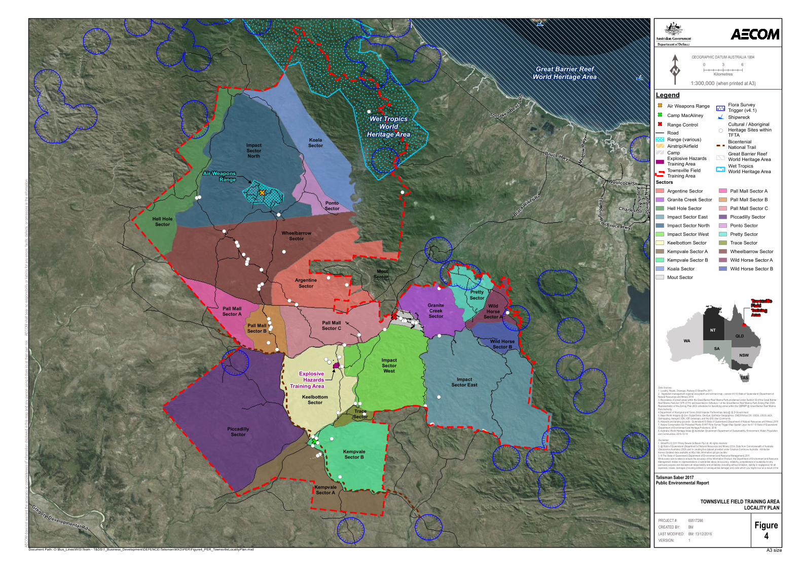
!(
!(
!(
!(
!(
!(
!(
ë
ë
!(!(!(
!(
!(!(
!(
!(!(
!(
!(
!(
!(!( !(!(!(!(
!(
!(!(!(
!(!(
!(
!(
!(
!(
!(
!(
!(!(
!(
!(!(
!(
!(
!(!(
!(
!(
!(!(!(
!(
!(
!(!(
!(
!(!(
!(
!(
!(!(
!(
!(!(!(!(!(!(
!(!(
!(!(!(
!(
Air WeaponsRange
ExplosiveHazards
Training Area
Hell HoleSector
ImpactSectorNorth
ArgentineSector
KoalaSector
PontoSector
WheelbarrowSector
ImpactSector East
GraniteCreekSector
Wild HorseSector B
WildHorse
Sector A
PrettySector
PiccadillySector
KempvaleSector A
Pall MallSector C
Pall MallSector A
Pall MallSector B
KeelbottomSector
ImpactSectorWest
TraceSector
KempvaleSector B
MoutSector
Great Barrier ReefWorld Heritage Area
Wet TropicsWorld
Heritage Area
Angus AvCharles St
NathanSt
Woolcock St
Mt Lo w
Pwy
Toola kea Beac hRd
TheRingRd (Bruce Hwy)
Black River R d
Gregory Developmental Rd
Bruce Hwy
0 3 6KilometresK
A3 sizeAECO
M does
not w
arrant
the ac
curacy
or com
pleten
ess of
informa
tion dis
played
in this
map a
nd any
perso
n usin
g it do
es so
at thei
r own ri
sk. A
ECOM
shall
bear no
respon
sibility
or liab
ility for
any e
rrors,
faults,
defec
ts, or o
missio
ns in t
he info
rmation
.
LegendGF Air Weapons RangeGF Camp MacAlineyGF Range Control
RoadRange (various)Airstrip/AirfieldCampExplosive Hazards Training AreaTownsville Field Training Area
Flora Survey Trigger (v4.1)
ë Shipwreck
!(
Cultural / Aboriginal Heritage Sites withinTFTABicentenial National TrailGreat Barrier ReefWorld Heritage AreaWet TropicsWorld Heritage Area
GEOGRAPHIC DATUM AUSTRALIA 1994
Figure4
Document Path: O:\Bus_Lines\WIS\Team - T&DS\1_Business_Development\DEFENCE\Talisman\MXD\PER\Figure4_PER_TownsvilleLocalityPlan.mxd
TOWNSVILLE FIELD TRAINING AREALOCALITY PLAN
Data Sources:1. Locality, Roads, Drainage, Railway © StreetPro 20112. Vegetation management regional ecosystem and remnant map - version 8.0 © State of Queensland (Department ofNatural Resources and Mines) 20163. Boundaries of zoned areas within the Great Barrier Reef Marine Park proclaimed under Section 32 of the Great BarrierReef Marine Park Act 1975 (CTH) and described in Schedule 1 of the Great Barrier Reef Marine Park Zoning Plan 2003.Representation of the Zoning Plan 2003 schedules for describing zones within the GBRMP @ Great Barrier Reef MarinePark Authority4.Department of Aboriginal and Torres Strait Islander Partnerships data @ QLD Government5. Base World Imagery @ Esri, DigitalGlobe, GeoEye, Earthstar Geographics, CNES/Airbus DS, USDA, USGS, AEX,Getmapping, Aerogrid, IGN, IGP, swisstopo, and the GIS User Community6. Heliports and landing grounds - Queensland © State of Queensland (Department of Natural Resources and Mines) 20167. Nature Conservation Act Protected Plants EVNT Flora Survey Trigger Map Spatial Layer Ver.4.1 © State of Queensland(Department of Environment and Heritage Protection), 20168. Australia, World Heritage Areas @ Australian Government Department of Sustainability, Environment, Water, Populationand Communities, 2015-10-14Disclaimer:1. StreetPro © 2011 Pitney Bowes Software Pty Ltd. All rights reserved2. @ State of Queensland (Department of Natural Resources and Mines) 2014. Data from Commonwealth of Australia(Geoscience Australia) 2009 used in creating this dataset provided under Creative Commons Australia - Attributionlicence.Updated data available at http://dds.information.qld.gov.au/dds/3. © The State of Queensland (Department of Environment and Resource Management) 2011.While every care is taken to ensure the accuracy of the Information Product, the Department of Environment and ResourceManagement makes no representations or warranties about its accuracy, reliability, completeness or suitability for anyparticular purpose and disclaims all responsibility and all liability (including without limitation, liability in negligence) for allexpenses, losses, damages (including indirect or consequential damage) and costs which you might incur as a result of the
PROJECT #:
LAST MODIFIED:CREATED BY:
60517266BM
VERSION: 1BM: 13/12/2016
Talisman Saber 2017Public Environmental Report
1:300,000 (when printed at A3)
QLD
NSWSA
NT
WA
TAS
TownsvilleFieldTrainingArea
SectorsArgentine SectorGranite Creek SectorHell Hole SectorImpact Sector EastImpact Sector NorthImpact Sector WestKeelbottom SectorKempvale Sector AKempvale Sector BKoala SectorMout Sector
Pall Mall Sector APall Mall Sector BPall Mall Sector CPiccadilly SectorPonto SectorPretty SectorTrace SectorWheelbarrow SectorWild Horse Sector AWild Horse Sector B
AECOM Talisman Saber 2017 Commercial-in-Confidence
21-Feb-2016 Prepared for – Department of Defence – ABN: 68706814312
31
5.3 Cowley Beach Training Area
Location and access 5.3.1
CBTA is located within the wet tropics region of far North Qld, approximately 40km south of Innisfail. The site is bounded by Browns Range and Inarlinga to the south, Cowley Beach to the east, Mourilyan Harbour to the north and the Moresby River system to the west. The regional locality of CBTA is shown in Figure 5.
The site includes Lindquist Island (located 1 km offshore) and a Defence Closure Area that extends seaward to the eastern edge of the Great Barrier Reef. Main access to the area is from the Bruce Highway on the Cowley Beach Road.
Exercises conducted at CBTA are concentrated in the cantonment area, on the rocket range, on Browns and Cowley Beaches, and on Browns and Esmeralda Ranges. Other than the road network, the majority of CBTA is not used for training activities.
Existing values 5.3.2
CBTA comprises 5,081ha of coastal lowland plains consisting of rainforest, woodland, swamps and 8 km of beaches. The site is part of the Cassowary Coast, which was significantly affected by Cyclone Yasi in early February 2011, with extensive damage occurring to vegetation and wildlife habitats. While this damage has largely regenerated, the Cassowary (listed as endangered under the EPBC Act) population around CBTA was affected by the habitat damage and has not yet fully recovered. With QPWS, Defence personnel established feeding stations to support local Cassowary populations. As CBTA extends seaward to the eastern edge of the Great Barrier Reef, coastal and marine environments are a significant part of this site.
CBTA contains part of the World Heritage-listed Property, ‘Wet Tropics of Queensland’ and its eastern boundary borders the GBRMP. Zoning of adjacent GBRMP waters include: ‘Conservation park’, ‘General Use’, ‘Habitat Protection’, ‘Marine National Park’ zones. Within the CBTA two threatened ecological communities potentially occur, ‘Littoral Rainforest and Coastal Vine Thickets of Eastern Australia’ (Critically Endangered) and ‘Broad Leaf Tea-tree (Melaleuca viridiflora) Woodlands in High Rainfall Coastal North Queensland’ (Endangered).
The majority of the CBTA occurs on Quaternary marine deposits with beach ridges and estuarine deposits in the eastern half of CBTA, and muds and clays in the western half of CBTA. There are a number of marine habitats in CBTA including, beaches and foredunes, mangroves, rocky intertidal areas, seagrass and coral reefs. On land, ecological communities include rainforest, open forests, wetlands, and freshwater swamps. There are also several sites of indigenous and non-indigenous significance within CBTA. Details of the environmental and heritage site values are provided in Appendix Q.
Potential impacts 5.3.3
Potential impacts on environmental and / or heritage values of CBTA from TS17 are primarily related to land based activities such as vehicle movements, amphibious landings, live firing exercises, field engineering and waste generation and management. As an existing training area, the proposed activities for TS17 already occur at the site at various times throughout the year, therefore the potential for adverse impacts on the natural environment should be considered in the context of the historical and ongoing use of the site as a Defence training area. Although there is potential for activities to affect environment and heritage values at the site, controls are in place to reduce the risks from these activities and additional mitigation measures would be put in place to manage these impacts (see Section 7.2).
AECOM Talisman Saber 2017 Commercial-in-Confidence
21-Feb-2016 Prepared for – Department of Defence – ABN: 68706814312
32
Site-specific policies, plans and control measures 5.3.4
In addition to the Defence-wide environmental management processes described in Section 4.5 and Appendix E, the following site-specific environmental controls apply to activities at CBTA:
Cowley Beach Training Area Land Management Plan: this is a site-specific document to facilitate the sustainable use of CBTA based on the Environmental Impact Assessment of Defence Training Activities at CBTA. The need for the Land Management Plan arose from the provisions of the Wet Tropics Management Plan (1998) policy document Protection through Partnerships (1997). Together, the Environmental Impact Assessment and EMP fulfil the Wet Tropics Management Plan policy of ‘an agreed Defence Use Management Code of Practice’ and an approved EMP for the CBTA. The Land Management Plan provides a strategy for managing training activities and maintenance activities.
Where it is identified that residual risks have a ‘Medium’ or ‘High’ risk rating despite the implementation of Defence-wide environmental management processes and site-specific control measures (see Section 6.2), additional issue-specific (e.g. contamination management) environmental controls (see Section 7.2) will be implemented for TS17 through Exercise Operational controls (see Section 7.8).

!(!(!(!(!(!(!(!(
!(!(
!(!(!(!(
!(!(
!(
Camp
Range Control
Helipad
Cowley BeachTownship
Great Barrier ReefWorld Heritage Area
BonersSector
HuntersSector
DixiSector
MegsSector
BrownsBeachSector
VK Sector
DoublePoint
SectorGreat
BarrierReef
Wet TropicsWorld Heritage Area
Coco
Rd
Marw
ickR dWells Rd
McCu tcheonRd
Karra
Rd
Bob R
d
Marano Rd
Aldridge Rd
Gangemi Rd
Jay Rd
Eden
Rd
Silvio Rd
StephensonRd
Cowley Beach Rd
0 0.5 1KilometresK
A3 sizeAECO
M does
not w
arrant
the ac
curacy
or com
pleten
ess of
informa
tion dis
played
in this
map a
nd any
perso
n usin
g it do
es so
at thei
r own ri
sk. A
ECOM
shall
bear no
respon
sibility
or liab
ility for
any e
rrors,
faults,
defec
ts, or o
missio
ns in t
he info
rmation
.
LegendRoadCowley Beach Training AreaCampCowley Beach TownshipHeliportRange ControlThreatened Ecological CommunitiesFlora Survey Trigger (v4.1)
!(Cultural / Aboriginal Heritage Sites within CBTAGreat Barrier Reef World Heritage AreaWet Tropics World Heritage Area
GEOGRAPHIC DATUM AUSTRALIA 1994
Figure5
Document Path: O:\Bus_Lines\WIS\Team - T&DS\1_Business_Development\DEFENCE\Talisman\MXD\PER\Figure5_PER_CowleyBTALocalityPlan.mxd
COWLEY BEACH TRAINING AREALOCALITY PLAN
Data Sources:1. Locality, Roads, Drainage, Railway © StreetPro 20112. Vegetation management regional ecosystem and remnant map - version 8.0 © State of Queensland (Department ofNatural Resources and Mines) 20163. Boundaries of zoned areas within the Great Barrier Reef Marine Park proclaimed under Section 32 of the Great BarrierReef Marine Park Act 1975 (CTH) and described in Schedule 1 of the Great Barrier Reef Marine Park Zoning Plan 2003.Representation of the Zoning Plan 2003 schedules for describing zones within the GBRMP @ Great Barrier Reef Marine ParkAuthority4.Department of Aboriginal and Torres Strait Islander Partnerships data @ QLD Government5. Base World Imagery @ Esri, DigitalGlobe, GeoEye, Earthstar Geographics, CNES/Airbus DS, USDA, USGS, AEX,Getmapping, Aerogrid, IGN, IGP, swisstopo, and the GIS User Community6. Heliports and landing grounds - Queensland © State of Queensland (Department of Natural Resources and Mines) 20167. Nature Conservation Act Protected Plants EVNT Flora Survey Trigger Map Spatial Layer Ver.4.1 © State of Queensland(Department of Environment and Heritage Protection), 2016Disclaimer:1. StreetPro © 2011 Pitney Bowes Software Pty Ltd. All rights reserved2. @ State of Queensland (Department of Natural Resources and Mines) 2014. Data from Commonwealth of Australia(Geoscience Australia) 2009 used in creating this dataset provided under Creative Commons Australia - Attributionlicence.Updated data available at http://dds.information.qld.gov.au/dds/3. © The State of Queensland (Department of Environment and Resource Management) 2011.While every care is taken to ensure the accuracy of the Information Product, the Department of Environment and ResourceManagement makes no representations or warranties about its accuracy, reliability, completeness or suitability for anyparticular purpose and disclaims all responsibility and all liability (including without limitation, liability in negligence) for allexpenses, losses, damages (including indirect or consequential damage) and costs which you might incur as a result of theproduct being inaccurate or incomplete in any way and for any reason.
PROJECT #:
LAST MODIFIED:CREATED BY:
60517266BM
VERSION: 1BM: 13/12/2016
Talisman Saber 2017Public Environmental Report
1:45,000 (when printed at A3)
QLD
NSWSA
NT
WA
TAS
Cowley BeachTrainingArea
SectorsBoners SectorBrowns Beach SectorDixi SectorDouble Point Sector
Hunters SectorMegs SectorVK Sector
Camp
Helipad
Cowley BeachTownship
GreenBeach
RangeControl
INSET0 100 200 300
Metres

AECOM Talisman Saber 2017 Commercial-in-Confidence
21-Feb-2016 Prepared for – Department of Defence – ABN: 68706814312
34
5.4 Mount Bundey Training Area
Location and access 5.4.1
The MBTA covers approximately 117,300ha and is located approximately 115km south east of Darwin Central Business District in the NT. The site is bounded by the Arnhem Highway to the north, Mary River and the proposed Mary River National Park to the west, and Naracoorte National Park to the east through to the south.
MBTA was established to support training in field manoeuvres and live firing. It has field firing areas, high explosive impact areas, training sectors and infrastructure to support management and operational use. Infrastructure at the site is limited, and includes a road network, maintenance areas, a Range Control facility, a 200 person ‘Scale A’ campsite and a number of support facilities, including purpose built ranges.
Access to MBTA is provided via the Arnhem Highway, which has direct connection to Stuart Highway, providing a direct transport link to Darwin. The site has an internal road network of unsealed gravel roads appropriate for all weather use, although movement is generally restricted during the wet season to prevent damage to roads and tracks, as well as damage to vehicles. A regional map showing MBTA is provided in Figure 6.
Existing values 5.4.2
MBTA borders the World Heritage Property ‘Kakadu National Park’ which is listed for its natural and cultural values. MBTA also adjoins the ‘Kakadu National Park and the Mary Floodplain System’, which are on the Directory of Important Wetlands in Australia. MBTA is drained to the north-west and north-east by the Mary and Wildman Rivers respectively. These wetlands and connections form essential refuges for migratory waterbirds and other fauna, especially during the dry season. The majority of MBTA is vegetated by Melaleuca savannah woodlands, open forests and grassed floodplains. MBTA is listed on the CHL for its natural heritage values and contains a number of indigenous archaeological sites including one registered and one recorded sacred site identified on the NT AAPA Sacred Sites Register. Details of the existing site values are provided in Appendix R.
Potential impacts
Potential impacts on environmental and / or heritage values of MBTA from TS17 are primarily related to land based activities such as vehicle movements, live firing exercises, field engineering and waste generation and management. As an existing training area, the proposed activities for TS17 already occur at the site at various times throughout the year, therefore the potential for adverse impacts on the natural environment should be considered in the context of the historical and ongoing use of the site as a Defence training area. Although there is potential for activities to affect environment and heritage values at the site, controls are in place to reduce the risks from these activities and additional mitigation measures would be put in place to manage these impacts (see Section 7.2).
Site-specific policies, plans and control measures 5.4.4
In addition to the Defence-wide environmental management processes described in Section 4.5 and Appendix E, the following site-specific environmental controls apply to activities at MBTA:
Mount Bundey Heritage and Environmental Management Plan (AECOM, 2010): provides an integrated framework and strategies for management of the significant natural and cultural heritage values at MBTA, including management requirements during major exercises; and
Mount Bundey Training Area Sustainability Monitoring and Reporting Plan which reviews values and activities and specifies monitoring activities and thresholds that trigger specific management actions.
Where it is identified that residual risks have a ‘Medium’ or ‘High’ risk rating despite the implementation of Defence-wide environmental management processes and site-specific control measures (see Section 6.2), additional issue-specific (e.g. spill management) environmental controls (see Section 7.2) will be implemented for TS17 through Exercise Operational controls (see Section 7.8).

Range Control
Urban OperationsTraining Facilities
Static Firing Point -Range Area
RNE: AligatorRivers Region
RNE: WildmanRiver Catchment
!(
WildmanSector
AnnaburrooSector
ArnhemSector
JabiruSector
Mary RiverSector
West RoadSector
MountainSector
Jim JimSector
CraigCreekSector
BarramundiSector
KakaduSector
MARY RIVER
Kakadu National ParkWorld Heritage Area
Arnhem Hwy Jim Jim Rd
Point Stuart Rd
0 2.5 5KilometresK
A3 sizeAECO
M does
not w
arrant
the ac
curacy
or com
pleten
ess of
informa
tion dis
played
in this
map a
nd any
perso
n usin
g it do
es so
at thei
r own ri
sk. A
ECOM
shall
bear no
respon
sibility
or liab
ility for
any e
rrors,
faults,
defec
ts, or o
missio
ns in t
he info
rmation
.
LegendRoadRange ControlStatic Firing Point -Range AreaUrban Operations Training FacilityMount Bundey Training Area
!( Sacred SiteKakadu National Park World Heritage AreaRegister of National Estate
GEOGRAPHIC DATUM AUSTRALIA 1994
Figure6
Document Path: O:\Bus_Lines\WIS\Team - T&DS\1_Business_Development\DEFENCE\Talisman\MXD\PER\Figure6_PER_MtBundeyLocalityPlan.mxd
MOUNT BUNDEY TRAINING AREALOCALITY PLAN
Data Sources:1. Locality, Roads, Airport/Airfield, Drainage, Railway © StreetPro 20112. Recorded Sacred SIte @ AAPA, 20053. Base World Imagery @ Esri, DigitalGlobe, GeoEye, Earthstar Geographics, CNES/Airbus DS, USDA, USGS, AEX,Getmapping, Aerogrid, IGN, IGP, swisstopo, and the GIS User CommunityDisclaimer:1. StreetPro © 2011 Pitney Bowes Software Pty Ltd. All rights reserved2. @ State of Queensland (Department of Natural Resources and Mines) 2014. Data from Commonwealth of Australia(Geoscience Australia) 2009 used in creating this dataset provided under Creative Commons Australia - Attributionlicence.Updated data available at http://dds.information.qld.gov.au/dds/3. © The State of Queensland (Department of Environment and Resource Management) 2011.
While every care is taken to ensure the accuracy of the Information Product, the Department of Environment andResource Management makes no representations or warranties about its accuracy, reliability, completeness orsuitability for any particular purpose and disclaims all responsibility and all liability (including without limitation, liability innegligence) for all expenses, losses, damages (including indirect or consequential damage) and costs which you mightincur as a result of the product being inaccurate or incomplete in any way and for any reason.
PROJECT #:
LAST MODIFIED:CREATED BY:
60517266BM
VERSION: 1BM: 13/12/2016
Talisman Saber 2017Public Environmental Report
1:155,000 (when printed at A3)
QLD
NSWSA
NT
WA
TAS
Mt. BundeyTraining Area
SectorsAnnaburroo SectorArnhem SectorBarramundi SectorCraig Creek SectorJabiru SectorJim Jim Sector
Kakadu SectorMary River SectorMountain SectorWest Road SectorWildman Sector

AECOM Talisman Saber 2017 Commercial-in-Confidence
21-Feb-2016 Prepared for – Department of Defence – ABN: 68706814312
36
5.5 Halifax Bay Training Area
Location and access 5.5.1
HBTA lies within the GMRMP, 25km north-west of Townsville and 14km off the coast. It consists of Rattlesnake Island, Acheron Island, Herald Island, Cordelia Rocks and Bramble Rocks. The islands are used for survival training, infantry minor tactics, command post exercises and live firing (on Rattlesnake Island only). Access is via helicopter or by sea.
The USMC and a Marine Extradition Unit will be conducting small boat landings at Herald Island in Halifax Bay. A regional map showing Halifax Bay is provided in Figure 7.
Existing values 5.5.2
HBTA falls within the GBRWHA and the Wet Tropics of Queensland WHA. The area is within the Commonwealth marine area and within the GBRMP. The threatened ecological communities ‘Littoral Rainforest and Coastal Vine Thickets of Eastern Australia’ (critically endangered), ‘Broad leaf tea-tree (Melaleuca viridiflora) woodlands in high rainfall coastal north Queensland’ (endangered) and ‘SEVT’ (endangered) with the potential to occur on the islands, A number of threatened, migratory, marine and cetacean species protected under the EPBC Act are likely to occur in the area with the marine environment in Halifax Bay a known nesting, foraging and breeding area for Flatback and Green Turtles as well as providing known habitat for Dugong and the Indo-pacific humpback dolphin and other protected marine species.
Details of the existing site values are provided in Appendix S.
Potential impacts 5.5.3
Potential impacts on environmental and / or heritage values of Halifax Bay relate to both maritime and air activities. The highest environmental risk posed by the planned maritime activities is identified as the introduction and dispersal of marine pest species in Australian waters. This risk is addressed through the Maritime Activities EMP and other biosecurity measures Defence has in place, noting the number of ship movements (approximately four ships) associated with TS17 are inconsequential compared to those associated with commercial merchant ship operations and previous Talisman Saber exercises. Additional mitigation measures will be implemented to further reduce these risks (see Section 7.2).
Site-specific policies, plans and control measures 5.5.4
Defence-wide environmental management processes described in Section 4.5 and Appendix E will apply to activities in Halifax Bay. Where it is identified that residual risks have a ‘Medium’ or ‘High’ risk rating despite the implementation of Defence-wide environmental management processes (see Section 7.2), additional issue-specific (e.g. waste management) environmental controls (see Section 7.2) will be implemented for TS17 through Exercise Operational controls (see Section 7.8).

;
;;
;
;
;
ë
ëë
ë
ëë
ë
ë
ë
ë
ë
ë
ë
ë
ë
ë
ë
ë
ë
ë
ë
ë
ë
ë
RattlesnakeIsland
HeraldIsland
HavannahIsland
AcheronReef
FlyIsland
PalmIslands
Great Barrier ReefWorld Heritage Area
Wet TropicsWorld
Heritage Area
PALM ISLAND FERRY
L AGOONTR AIL
BRUCE HIGHWAY
SAUN
DE
RS BEACH
ROAD
PRIVATEROAD
TRACK
PRIVATE ROAD
TRACK
LOCAL ROAD
PATH
PR IVATE ROAD TRACK
BLUEWATERDRIVE
PURO
NOPA
RKWAY
PRIVATEROAD
TRACK
PACE
RO
AD
HENCAM
P CREEKROAD
PRIVATE ROAD
ESPLANADE
FORES
TRY ROAD
PR IVAT EROAD
ESPLANADE
LOCA
LROAD
LOCAL ROAD
VERR
ALL R
OAD
WEST
PO
INT RO
AD
ESPLANADE
ESPLANADE
LOCAL ROAD
PATH
0 0.5 1KilometresK
A3 sizeAECO
M does
not w
arrant
the ac
curacy
or com
pleten
ess of
informa
tion dis
played
in this
map a
nd any
perso
n usin
g it do
es so
at thei
r own ri
sk. A
ECOM
shall
bear no
respon
sibility
or liab
ility for
any e
rrors,
faults,
defec
ts, or o
missio
ns in t
he info
rmation
.
LegendRoadPalm Island FerryHalifax Bay Air Weapons RangeHalifax Bay Air Weapons Range Danger Template
ë Shipwreck; World War 2 Heritage Places
Great Barrier Reef World Heritage AreaWet Tropics World Heritage AreaFlora Survey Trigger (v4.1)
GEOGRAPHIC DATUM AUSTRALIA 1994
Figure7
Document Path: O:\Bus_Lines\WIS\Team - T&DS\1_Business_Development\DEFENCE\Talisman\MXD\PER\Figure8_PER_TownsvilleHalifaxBay.mxd
HALIFAX BAY AIR WEAPONS RANGELOCALITY PLAN
Data Sources:1. Locality, Roads, Drainage, Railway © StreetPro 20112. Vegetation management regional ecosystem and remnant map - version 8.0 © State of Queensland (Department ofNatural Resources and Mines) 20163. Boundaries of zoned areas within the Great Barrier Reef Marine Park proclaimed under Section 32 of the Great BarrierReef Marine Park Act 1975 (CTH) and described in Schedule 1 of the Great Barrier Reef Marine Park Zoning Plan 2003.Representation of the Zoning Plan 2003 schedules for describing zones within the GBRMP @ Great Barrier Reef MarinePark Authority4.Department of Aboriginal and Torres Strait Islander Partnerships data @ QLD Government5. Base World Imagery @ Esri, DigitalGlobe, GeoEye, Earthstar Geographics, CNES/Airbus DS, USDA, USGS, AEX,Getmapping, Aerogrid, IGN, IGP, swisstopo, and the GIS User Community6. Heliports and landing grounds - Queensland © State of Queensland (Department of Natural Resources and Mines) 20167. Nature Conservation Act Protected Plants EVNT Flora Survey Trigger Map Spatial Layer Ver.4.1 © State of Queensland(Department of Environment and Heritage Protection), 20168. Australia, World Heritage Areas @ Australian Government Department of Sustainability, Environment, Water, Populationand Communities, 2015-10-14Disclaimer:1. StreetPro © 2011 Pitney Bowes Software Pty Ltd. All rights reserved2. @ State of Queensland (Department of Natural Resources and Mines) 2014. Data from Commonwealth of Australia(Geoscience Australia) 2009 used in creating this dataset provided under Creative Commons Australia - Attributionlicence.Updated data available at http://dds.information.qld.gov.au/dds/3. © The State of Queensland (Department of Environment and Resource Management) 2011.While every care is taken to ensure the accuracy of the Information Product, the Department of Environment and ResourceManagement makes no representations or warranties about its accuracy, reliability, completeness or suitability for anyparticular purpose and disclaims all responsibility and all liability (including without limitation, liability in negligence) for allexpenses, losses, damages (including indirect or consequential damage) and costs which you might incur as a result of the
PROJECT #:
LAST MODIFIED:CREATED BY:
60517266BM
VERSION: 1BM: 14/12/2016
Talisman Saber 2017Public Environmental Report
1:200,000 (when printed at A3)
QLD
NSWSA
NT
WA
TAS
Halifax Bay Air Weapons Range

AECOM Talisman Saber 2017 Commercial-in-Confidence
21-Feb-2016 Prepared for – Department of Defence – ABN: 68706814312
38
5.6 Stanage Bay area
Location and access 5.6.1
As part of TS17, it is proposed to undertake amphibious beach landing activities and associated hinterland activities in the vicinity of Stanage Bay, Qld over approximately eight consecutive days in July 2017. The Stanage Bay area is located on the eastern side of the Torilla Peninsula bounded generally by Stanage Bay Township to the north, the coastline to the east, the boundary of SWBTA to the south, and 500m west of Stanage Bay Road to the west. The land-based footprint of the proposed area of use is approximately 3,325ha.
The proposed activities for this area includes a tactical scenario using small boats at five small BLSs and associated land-based positions (includes use of blank ammunition), a main amphibious landing, support activities by rotary and fixed wing aircraft (see Figure 8 for a map showing the locality of Stanage Bay and the areas proposed for use). Travel between BLSs and other operational sites will be by public roads and established tracks. At the conclusion of the activity the participants will move in convoy to SWBTA and vehicles and equipment will be cleaned inside the immediate area of the Grey Gate at SWBTA.
The activities proposed at these sites have been subject to a separate environmental impact assessment, TS17 Stanage Bay Amphibious Landing Environment Report (AECOM, 2016) (see Attachment 1- Stanage Bay Environmental Report). The report provides additional detail on the proposed activities. The report concluded that, based on the description of the action and outcomes of the impact assessment, that the beach landing and inland manoeuvre activities will not have a real chance or possibility of resulting in a significant impact on a MNES or ‘the environment’ as defined in Section 528 of the EPBC Act. The short-term nature of the action in combination with implementation of recommended mitigation measures supported this conclusion.
The findings of the Stanage Bay Amphibious Landing Environment Report have been incorporated into this PER. The values of the area and potential impacts are described below. The EPBC Act Significant Impact tests in Section 8.0 incorporate the values and potential impacts to the Stanage Bay area.
Existing values 5.6.2
The marine portion of Stanage Bay encompasses areas of the GBRWHA and the southern portion of the activity area coincides with the Ramsar site, ‘Shoalwater and Corio Bays area’. It comprises a variety of environments including sandy beaches, dunes, intertidal mudflats backed by mangroves, coastal wetlands, tidally influenced creeks, rocky headlands, vine thickets, eucalypt woodlands, Thick Melaleuca groves and periodically inundated herbfields. One ‘Endangered’ threatened ecological community is also mapped along much of the dune systems in the Stanage Bay area, ‘SEVT’.
The marine environment in the Stanage Bay area is recognised as an important nesting, foraging and breeding area for Flatback Turtles as well as providing known habitat for Dugong, Southern Humpback Dolphin, five of Australia’s six marine turtle species, and other protected marine species. Seagrass beds are also mapped as present along a number of the beaches proposed for use.
A number of Weeds of National Significance have been identified as potentially occurring within the Stanage Bay area and are likely a result of heavy recreational use of the beaches within the activity area. The primary land uses at Stanage Bay and the surrounding areas are recreational fishing and boating, local tourism, pastoral / agricultural, and pine plantations.
Both the Indigenous and Historical heritage values at Stanage Bay are poorly understood generally due to a lack of systematic assessment of the area. It currently has three registered Aboriginal heritage sites in the proposed activity area but there are likely to be more due to lack of detailed archaeological assessment. Camp sites, middens and stone artefact processing sites are likely to be found within the beach foredune areas and anywhere with freshwater. Burial sites can also be found in soft sand in foredunes. In addition to archaeological sites, there are a number of landforms (rocky outcrops, fossilised coral, waterholes and headlands) that are likely to have intangible cultural heritage importance to local Aboriginal people (i.e. sacred sites). These are typically associated with landform and ecological features that are unique in an area.
AECOM Talisman Saber 2017 Commercial-in-Confidence
21-Feb-2016 Prepared for – Department of Defence – ABN: 68706814312
39
Potential impacts
Potential impacts on environmental and / or heritage values of the Stanage Bay area from TS17 are primarily related to land based activities such as vehicle movements, amphibious landings and minor field engineering. Maritime activities at Stanage Bay were assessed from the LAT level inland with maritime activities beyond the LAT level assessed as part of the Coral Sea, including the Great Barrier Reef Marine Park. These activities will be of a short duration and will maximise use of existing infrastructure to reduce the risk of impacts. Additional mitigation measures will be put in place to manage these impacts (see Section 7.2).
The amphibious landing planned for the BLSs in the Stanage Bay area is intended to include use of the LLC which is a new platform and has not been used previously for Talisman Saber exercises. The LLC differs from other amphibious platforms in that it uses water jets for propulsion and this has the potential to cause impacts to beaches and beach approaches. The potential impacts have been assessed by Umwelt on behalf of Defence who determined that “…in beaches with lower wave/wind energy levels, sites are more readily disturbed… and they present a higher likelihood that larger numbers of more sensitive biodiversity values will be present. Lower energy sites will have lower recovery rates.” (Umwelt 2017). Umwelt determined that the beaches at Stanage Bay are moderate energy beaches and therefore the risk of significant impacts is decreased (Umwelt 2017), however the recommended mitigation measures for use of LLCs will still be implemented. These mitigation measures have been included in Section 7.0 and will be implemented through operation controls as part of the Exercise.
Site-specific policies, plans and control measures 5.6.4
In addition to the Defence-wide environmental management processes described in Section 4.5 and Appendix E, the following specific environmental controls apply to activities at Stanage Bay as this will be considered to be a NDTA for the purpose of the activity:
SOs for NDTA: These SOs provide specific day-to-day operational guidance for all ADF formations units, ADO, ADF Cadets, organisations and personnel including contractors and non-Defence personnel who are authorised to use an NDTA for Defence purposes. They provide minimum safety measures, individual responsibilities, processes and procedures to minimise and manage the risk associated with activities in NDTAs. They include designation of temporary or permanent ‘off-limits’ areas for safety, environmental or heritage management considerations; and
Permissive Occupancy: Defence will comply with any landowner conditions agreed to during land access negotiations.
Where it is identified that residual risks have a ‘Medium’ or ‘High’ risk rating despite the implementation of Defence-wide environmental management processes (see Section 6.2), additional issue-specific (e.g. heritage management) environmental controls (see Section 7.2) will be implemented for TS17 through Exercise Operational controls (see Section 7.8).

[·
[·
[·
")")
")")
")
")
")
")
")
")
")
GFGF GF
GFGF
GFGF
GF
GF
GF GF
ë
ë
!(
!(!(
Great Barrier ReefWorld Heritage Area
STANAGE BAY RDShoalwater and CorioBays Area (Shoalwater
Bay Training Area,in part - Corio Bay)
Kelly's Airstrip
Hollins Creek Airstrip
Hollins Bay Airstrip
0 2.5 5KilometresK
A3 sizeAECOM does not warrant the accuracy or completeness of information displayed in this map and any person using it does so at their own risk. AECOM shall bear no responsibility or liability for any errors, faults, defects, or omissions in the information.
Legend[· Airstrips") Beach Landing Sites") Small Boat Landing
GF Tactical PositionsAccess TracksMSRStanage Bay Exercise AreaThreatened Ecological CommunitiesRamsar Wetlands
GEOGRAPHIC DATU M AU STRALIA 1994
Figure8
Document Path: O:\Bus_Lines\WIS\Team - T&DS\1_Business_Development\DEFENCE\Talisman\MXD\PER\Figure7_PER_SBALocalityPlan.mxd
STANAGE BAY LOCALITY PLAN
Data Sources:1. Loca lity, Roa ds © StreetPro 20112. V egeta tion m a n a gem en t region a l ecosystem a n d rem n a n t m a p - version 8.0 © Sta te of Queen sla n d (Departm en t ofNa tura l Resources a n d M in es) 20163. La n din g Sites,Tra in in g Area s Boun da ry, AirStrip @ Defen ce, 20164. Sea gra ss © All Rights (in cludin g copyright) CSIRO Austra lia 20155. Sea gra ss M ea dows © TropWATER 20146. Ca da stre © Sta te of Queen sla n d (Departm en t of Na tura l Resources a n d M in es) 20167. Queen sla n d Wetla n d Da ta V ersion 4.0 – Wetla n d area s 2013 @ Departm en t of En viron m en t a n d Herita geProtection , 20138. M a tters of Sta te En viron m en ta l Sign ifica n ce (V _ 4.1) © Sta te of Queen sla n d (Depa rtm en t of En viron m en t a n dHerita ge Protection) 20169. Grea t Barrier Reef Z on in g 2008 © Sta te of Queen sla n d (Departm en t of Na tion a l Pa rks, Sport a n d Ra cin g) 201610. Waterwa y Ba rrier Works © Sta te of Queen sla n d (Depa rtm en t of Agriculture a n d Fisheries) 201611. Directory of Importa n t Wetla n ds © Sta te of Queen sla n d (Departm en t of En viron m en t a n d Herita ge Protection) 201612. Atla s of Livin g Austra lia Records provided b y Queen sla n d Herb a rium , a ccessed through ALA website. For morein form a tion : http://collection s.a la .org.a u/pub lic/show/Disclaimer:1. StreetPro © 2011 Pitn ey Bowes Softwa re Pty Ltd. All rights reserved2. @ Sta te of Queen sla n d (Depa rtm en t of Natura l Resources a n d M in es) 2014. Data from Com mon wea lth of Austra lia(Geoscien ce Austra lia ) 2009 used in crea tin g this da ta set provided un der Crea tive Com m on s Austra lia - Attrib utionlicen ce.U pda ted da ta a va ila b le a t http://dds.in form a tion.qld.gov.a u/dds/3. © The Sta te of Queen sla n d (Departm en t of En viron m en t a n d Resource M a n a gem en t) 2011. While every ca re ista ken to ensure the a ccura cy of the In form a tion Product, the Depa rtm en t of En viron m en t a n d Resource M a n a gem en tm a kes no represen ta tion s or wa rra n ties a b out its a ccura cy, relia b ility, com pleten ess or suita b ility for a n y pa rticula rpurpose a n d discla im s a ll responsib ility a n d a ll lia b ility (in cludin g without lim ita tion , lia b ility in n egligen ce) for a llexpen ses, losses, da m a ges (in cludin g in direct or con sequen tia l da m a ge) a n d costs which you m ight in cur a s a result ofthe product b ein g in a ccura te or in complete in a n y wa y a n d for a n y rea son .
PROJECT #:
LAST M ODIFIED:CREATED BY:
60517266BM
V ERSION: 1BM : 13/12/2016
Talisman Saber 2017Public Environmental Report
1:125,000 (when prin ted a t A3)
QLD
NSWSA
NT
WA
TAS
StanageBay
!( Cultural / Aboriginal Heritage within Stanage Bay ë Shipwreck
Great Barrier Reef World Heritage Area

AECOM Talisman Saber 2017 Commercial-in-Confidence
21-Feb-2016 Prepared for – Department of Defence – ABN: 68706814312
41
5.7 Timor and Arafura Seas
Location 5.7.1
TS17 activities that take place within the Timor and Arafura Seas will fall within the North Marine Region comprising Commonwealth waters from west Cape York Peninsula to the NT –Western Australia border. The region covers approximately 625,689 square kilometres of tropical waters in the Gulf of Carpentaria and Arafura and Timor seas, and abuts the coastal waters of Qld and the NT (refer to Figure 1 for the locality of these areas).
The activities within the Timor and Arafura Seas will consist of maritime exercises comprising fleet manoeuvre and engagement, anti-submarine warfare, and non-combat helicopter support.
The North Marine Region is governed by a Bioregional Plan, prepared pursuant to the EPBC Act (DSEWPaC, 2012a). The plan does not cover state or territory waters but, where relevant, does include information about inshore environments and the way they interact with species and habitats of the Commonwealth marine area.
The Plan identifies a range of conservation values in the North Marine Region, comprising eight key ecological features, species listed under Part 13 of the EPBC Act that live in the North Marine Region and biologically important areas and protected places including marine reserves, heritage places and historic shipwrecks.
In terms of potential risks to the environment, it should be recognised that only small boats, if anything, are likely to operate in the coastal (i.e. State / Territory) margins of the North Marine Region. Given the artificiality of the ‘boundary’ between these and Commonwealth waters and the similarity of environmental settings, risk mitigation measures and standard practices employed to limit any potential risks in Commonwealth waters would have similar application in State / Territory waters.
Existing values 5.7.2
The Timor and Arafura Seas contain a variety of marine environments including seagrass beds, mangroves, coral reefs, and freshwater lagoons along with eight key ecological features identified in the North marine Region. These environments support a range of threatened and migratory marine species listed under the EPBC Act. The listed Ramsar wetlands ‘Ashmore Reef National Nature Reserve’ (listed on the CHL) and ‘Cobourg Peninsula Wildlife Sanctuary’ are located in proximity to the Timor and Arafura Seas. One historic shipwreck is also located in the North marine region. Details of the existing site values are provided in Appendix U.
Potential impacts 5.7.3
Potential impacts on environmental and / or heritage values of the Timor and Arafura Seas relate to both maritime and air activities. The highest environmental risk posed by the planned maritime activities is identified as the introduction and dispersal of marine pest species in Australian waters. This risk is addressed through the Maritime Activities EMP and other biosecurity measures Defence has in place, noting the number of ship movements (approximately four ships) associated with TS17 are inconsequential compared to those associated with commercial merchant ship operations and previous Talisman Saber exercises. Additional mitigation measures will be implemented to further reduce these risks (see Section 7.2).
Site-specific policies, plans and control measures 5.7.4
Defence-wide environmental management processes described in Section 4.5 and Appendix E will apply to activities in the Timor and Arafura seas. Where it is identified that residual risks have a ‘Medium’ or ‘High’ risk rating despite the implementation of Defence-wide environmental management processes (see Section 6.2), additional issue-specific (e.g. spill management) environmental controls (see Section 7.2) will be implemented for TS17 through Exercise Operational controls (see Section 7.8).

AECOM Talisman Saber 2017 Commercial-in-Confidence
21-Feb-2016 Prepared for – Department of Defence – ABN: 68706814312
42
5.8 Coral Sea (including Saumarez Reef Air Weapons Range)
Location 5.8.1
The Coral Sea is located along the north east coast of Australia, between Qld (east of and excluding the Great Barrier Reef), New Guinea and Vanuatu (refer to Figure 1 for the locality of these areas). It is approximately 989 842 km2 and is bordered by the Torres Strait Protected Zone to the north, the limits of Australian Exclusive Economic Zone (EEZ) on its eastern border and the GBRMP to the west. It includes a number of Gazetted Defence Practice Areas including the Saumarez Reef Air Weapons Range. Vessels will transit through the GBRMP and the Coral Sea Commonwealth Marine Reserve – potential impacts on values within these Marine Protected Areas are captured under their respective and specific locations (e.g. SWBTA, CBTA). Activities within the Coral Sea are governed by the ADF Maritime Activities EMP
The Coral Sea Commonwealth Marine Reserve encompasses the former Coral Sea Conservation Zone, former Coringa-Herald National Nature Reserve and former Lihou Reef National Nature Reserve noting that TS17 has no planned activities within the Coringa-Herald or Lihou Reef National Nature Reserves. The statutory process for developing new reserve management plans has commenced and the plans are expected to be released mid-2017. The new reserve will provide a greater level of protection to the conservation and heritage values of the area and will have six zones with varying levels of protection from general use including tourism, aquaculture and some commercial fishing, to strictly protected ‘no-take’ nature reserves. It is intended that Defence activities will be permitted as ‘General Use’ in all Zones of the Coral Sea Commonwealth Marine Reserve (see the Commonwealth Marine Reserves Review: Report of the Bioregional Advisory Panel at http://www.environment.gov.au/system/files/pages/23061bf8-df19-4b74-b867-5a57ccbc5c8b/files/cmrreviewbioregionaladvisorypanelreportfinal_1.pdf for further information). Activities within the Coral Sea Commonwealth Marine Reserve will be consistent with current agreed Defence uses of the area and in accordance with DoEE’s approval for Defence to continue existing uses of the area
The GBRMP is 344,400 km2 in area falls within the Coral Sea commencing south of the Torres Strait and stretching approximately 2,300 km along the coast of QLD down to the same latitude as the Coral Sea reserve (to the north of the town of Bundaberg). The GBRMP ends at the low tide mark on the shore and TS17 activities will be conducted within this area as well as within the broader Marine Park and Coral Sea.
Saumarez Reef is located approximately 330 km north east of Gladstone, within the Coral Sea Commonwealth Marine Reserve but outside of the GBRMP. It is one of the southernmost reefs to be located on the Coral Sea Shelf. The site contains three main reefs and two sand cays (North East Cay and South West Cay). The Saumarez Reef Danger Area is a declared Defence Practice Area promulgated in Commonwealth Gazette No. GN 46 (P 2997) dated 23 Nov 94. The site is recommended as a Habitat Protection Zone (IUCN IV), reflecting the sensitive environmental values of the site. The reef is known for a high density of shark species and is considered a nursery site for sharks and mid-sized predatory fish.
Existing values 5.8.2
The Coral Sea and Saumarez Reef Air Weapons Range contain a variety of habitats including coral reefs, several islets comprising sandy habitat, forest, shrubland, seagrasses and mangroves, and lagoons. The Coral Sea is also important for recreational fishing, charter fishing, the marine aquarium trade, commercial fishing, tourism, whale-watching and diving.
The Saumarez Reefs and surrounding area lies within the Coral Sea Commonwealth Marine Reserve which has been listed as a Conservation Protection Zone (IUCN IV) and Multiple Use Zone (IUCN VI). The area has also been recommended to become Habitat Protection Zone (reefs) (IUCN IV). The Coral Sea and Saumarez Reef contain a number of shipwrecks, grave sites, artefacts, and other heritage sites. Details of the existing area values are provided in Appendix V.
The area supports high species richness and endemism with higher fish and shark biomass particularly in existing protection zones. It is for these reasons, amongst others, that it was argued that

AECOM Talisman Saber 2017 Commercial-in-Confidence
21-Feb-2016 Prepared for – Department of Defence – ABN: 68706814312
43
the Commonwealth Marine Reserve was required to provide even greater protection of the reefs and seas in the area.
One of the values of the Coral Sea is that this is the location of the only known predictable aggregation of Dwarf Minke Whales in the world (see http://www.minkewhaleproject.org/).
Potential Impacts 5.8.3
Potential impacts on environmental and / or heritage values of the Coral Sea relate to both maritime and air activities. Amphibious activities occurring at SWBTA and Stanage Bay are assessed from LAT inland as part of the assessments for those sites, and from LAT seaward the activities under the Coral Sea sections. The highest environmental risk posed by the planned maritime activities is identified as the introduction and dispersal of marine pest species in Australian waters. This risk is addressed through the Maritime Activities EMP and other biosecurity measures Defence has in place, noting the number of ship movements associated with TS17 are inconsequential compared to those associated with commercial merchant ship operations. Additional mitigation measures will be implemented to further reduce these risks (see Section 7.2).
The activities that are proposed for TS17 in the Coral Sea are essentially the same as the activities that occurred as part of TS13. The mitigation measures and control measures for TS13 were also essentially the same as proposed for TS17 and included identification of discharge boxes within the GBRMP; restriction of the use of sonar in accordance with the Maritime Activities EMP considering the potential for encountering whales; reporting of whale sightings to GBRMP; suspension of firing when whales observed in target area; and requirements for slow speeds close to the coast.
The TS13 Post Exercise Environment Report noted that there were frequent sightings of marine mammals in open waters and that crews were vigilant in implementing procedures to detect, observe and avoid the possibility of colliding with these animals. There were no reports of any harm caused to marine mammals. There was a high profile incident where both inert and unarmed ordnance was jettisoned in the GBRMP and Defence worked in partnership with the GBRMP to determine the most suitable methods to manage the incident. Asides from this incident and two other minor incidents (loss of a bin overboard when waves broke over the deck, and accidental discharge of black water outside of a specified discharge box in the GBRMP), it was found that the risks of impact to the Coral Sea values from TS13 were effectively mitigated through the Maritime Activities EMP and through implementation of the Exercise EMP.
Site-specific policies, plans and control measures 5.8.4
Defence-wide environmental management processes described in Section 4.5 and Appendix E will apply to activities in the Coral Sea and Saumarez Reef Air Weapons Range. Where it is identified that residual risks have a ‘Medium’ or ‘High’ risk rating despite the implementation of Defence-wide environmental management processes (see Section 6.2), additional issue-specific (e.g. marine animal management) environmental controls (see Section 7.2) will be implemented for TS17 through Exercise Operational controls (see Section 7.8).

AECOM Talisman Saber 2017 Commercial-in-Confidence
21-Feb-2016 Prepared for – Department of Defence – ABN: 68706814312
44
5.9 RAAF bases and civil airports
A number of RAAF bases and civil airports will be utilised for military and civil aircraft movements and to facilitate movement of personnel and equipment between Defence locations. A list and description of these sites is provided below in Table 5.
Table 5 RAAF bases and civil airports to be used for TS17
Base or civil airport name
Site description
RAAF Base Darwin, NT
RAAF Base Darwin covers an area of approximately 1,300 ha and is located 6.5km from the Darwin Central Business District. The Base shares the runway with Darwin International Airport, which is located just northwest of the RAAF Base. The combined RAAF Base / Airport site is identified as a Joint User Airport under the Commonwealth Airports Act 1996. Military aircraft operations and civil aircraft operations – regular passenger and general aviation – are co-ordinated and directed by the Darwin Air Traffic Control tower. Surrounding land uses include recreation, residential areas, open space, semi broad acre commercial and agricultural development, rural small holdings and light industrial uses. The RAAF Base is located at the headwaters of the Rapid Creek catchment which includes Marrara Swamp. Both Rapid Creek and Marrara Swamp are considered environmentally significant as the only fresh water bodies in Darwin. A number of places on the CHL exist within the base. These include the Commanding Officer’s Residence, Water Tower, and two types of Tropical House. In addition, the Base Precinct (including on-Base living accommodations, messing, cinema, chapel, and its overall layout and streetscape) is on the CHL.
RAAF Base Tindal, Northern Territory
RAAF Base Tindal is the main tactical fighter Base in the NT and is located approximately 320km south-east of Darwin and approximately 15km south-east of the township of Katherine. The base lies adjacent to the Stuart Highway, which provides direct access to Katherine and Darwin. RAAF Base Tindal covers approximately 29,000ha of land.
As the main fighter aircraft base in the NT, the site regularly hosts both Australian and foreign fighter squadrons, including US and other nations.
Tindal Creek flows through the site, a tributary of the Katherine River, and is an ephemeral stream that is subject to flooding. The base is underlain by Tindal limestone and there are numerous sinkholes at the site that may support rainforest habitats as well as the potential for caves that support troglodytic fauna. The Base is surrounded by pastoral and agricultural land, quarries and the Cutta Cutta Caves National Park. Sacred sites are recorded in the wider Base area in addition to a number of highly significant Indigenous archaeological sites.
RAAF Base Townsville, North Queensland
RAAF Base Townsville is located on approximately 900ha of land, 5km north west of the Townsville Central Business District. The base’s air movement areas and some airside services are shared with the Townsville International Airport. The combined RAAF Base / Airport site is identified as a Joint User Airport under the Commonwealth Airports Act 1996. Military aircraft operations and civil aircraft operations – regular passenger and general aviation – are co-ordinated and directed by the Townsville Air Traffic Control tower.
The surrounding land uses include sanitary and cemetery uses to the south, civil aviation facilities to the east, light industrial uses to the west, open public spaces to the north (Rowes Bay) and the Townsville Town Common Conservation Park, which is an ephemeral wetland managed by Queensland Parks and Wildlife Service. The RAAF Base is built on low lying wetlands and coastal sediments and forms part of the local wetlands system that includes the Town Commons.
AECOM Talisman Saber 2017 Commercial-in-Confidence
21-Feb-2016 Prepared for – Department of Defence – ABN: 68706814312
45
Base or civil airport name
Site description
RAAF Base Amberley, South Queensland
RAAF Base Amberley is the largest operational base for the ADF with a size of over 1,600ha and is located 7km from Ipswich and 50km southwest of Brisbane. The Cunningham Highway runs close to the Base and provides the major road link.
The Base is bordered to the north, west and east by the Bremer River, and Warrill Creek to the south and east. The proximity and nature of these waterways poses a flood risk to proximate portions of the Base. The area surrounding the Base is primarily agricultural, with some residential areas which lead into Ipswich city to the north-east. A number of historic heritage places on the CHL exist within the base.
Rockhampton Airport, Central Queensland
Rockhampton Airport is located 5km from the Rockhampton Central Business District, with immediate surrounds comprising predominantly residential, light industrial and agricultural land uses.
This airport is often utilised for the transport of military personnel (including by direct international charter and military airlift) to Rockhampton Airport for transit to SWBTA, which is located approximately 70km to the north. To facilitate this, Defence leases facilities at Rockhampton Airport. Rockhampton has traditionally been the main logistic and administrative support location for major Exercises.
RAAF Base Williamtown
RAAF Base Williamtown is located approximately 20km north of Newcastle (NSW)
It is located adjacent to pastoral land, to Stockton Beach (Worimi Conservation Land) and the Tomago Sandbeds (Hunter Water Catchment Area).
RAAF Base Richmond NSW
RAAF Base Richmond is located between the communities of Windsor and Richmond of the Sydney Metropolitan Area, and approximately 50 km to the north west of Sydney Central Business District. It is bound to the northern side by agricultural land uses leading down to the Hawkesbury River. On the southern side are residential and other urban land uses.
RAAF Base Richmond is contained on the CHL for its historic heritage values.
The base is known for its transport aircraft including Hercules aircraft supplying military equipment and various supplies – particularly in support of disaster relief.
There will be a comparatively minor requirement for aircraft movement of personnel and equipment, refuelling of aircraft and force build-up requiring landing and take-off of military aircraft at Brisbane and Cairns airports. This is routine in nature for both military aircraft and the airports.
The types of activities proposed at RAAF bases during TS17 (refer Section 3.3.1) are consistent with those typically undertaken at these facilities. The key difference during TS17 will be the scale of operations, with both bases and civil airports expected to receive a higher volume of military aircraft and associated personnel.
Defence-wide environmental management processes described in Section 4.5 and Appendix E will apply to activities at the identified RAAF bases and civilian airports. Where it is identified that residual risks have a ‘Medium’ or ‘High’ risk rating despite the implementation of Defence-wide environmental management processes (see Section 6.2), additional issue-specific (e.g. noise management) environmental controls (see Section 7.2) will be implemented for TS17 through Exercise Operational controls (see Section 7.8).
5.10 Depots and staging sites
Depots and staging sites will be utilised for a range of support activities, including temporary sleeping and living arrangements, and equipment and vehicle storage and maintenance. A description of these sites is provided below in Table 6.
In addition to the list below, staging may be undertaken at other Defence sites, such as internally within Training areas; however, those staging activities will be captured as part of the overall planned activities in the training area.

AECOM Talisman Saber 2017 Commercial-in-Confidence
21-Feb-2016 Prepared for – Department of Defence – ABN: 68706814312
46
Table 6 Depots and staging sites to be used for TS17
Depot site Site description
Western Street Rockhampton Multi-User Depot, Central Queensland
This site is at 68 Western Street, Rockhampton, Qld. The site is approximately 37.6ha and is located adjacent to Rockhampton Airport. The site is used primarily as a multi-user depot for reserve personnel, and is also used to support exercises conducted in SWBTA. Facilities at this site include purpose built facilities for operations support, vehicle washing and cleaning for traffic into and out of SWBTA, and a 1,800 person camp.
Sarina Showgrounds
The Sarina Showgrounds are located on the Bruce Highway in Mackay, Qld. The site is used for a range of shows and events such as the Sarina markets and the Sarina Agricultural Show.
The site will be used as a staging area for Exercise TS17.
The types of activities proposed at depots and staging sites during TS17 are consistent with those typically undertaken at these facilities. The key difference during TS17 will be the scale of operations, with the sites expected to be occupied by up to 2,000 personnel and vehicle movements to and from site to be significantly increased.
Defence-wide environmental management processes described in Section 4.5 and Appendix E will apply to activities at the identified RAAF bases and civilian airports. Where it is identified that residual risks have a ‘Medium’ or ‘High’ risk rating despite the implementation of Defence-wide environmental management processes (see Section 6.2), additional issue-specific (e.g. watercourse management) environmental controls (see Section 7.2) will be implemented for TS17 through Exercise Operational controls (see Section 7.8).
5.11 Port facilities
A number of port facilities will be utilised for entry and exit of personnel, discharge of cargo (such as to support Training Areas and minimise highway road traffic) and to support naval vessel departures to, and return from, off-shore exercise activities. A list and description of these Ports is provided below in Table 7. All ports are operational 24 hours per day, seven days a week.
Table 7 Port facilities to be used for TS17
Port Facilities
Port Facility Site Descriptions
Darwin Port A naturally occurring port, the Darwin Port is one of the only ports near an urban centre on the northern coast of Australia. It provides access to coastal areas east and west, and to shipping routes into Asia. This Port consists of three civil use wharfs and port facilities at HMAS Coonawarra (mainly patrol boats). The three civil wharfs are:
East Arm Wharf – mainly for cargo of containers and resource based goods;
Stokes Wharf – primarily a tourist location of non-maritime function. Also provides the embarkation point for harbour cruises; and
Fort Hill Wharf – predominantly used for cruise ship docking and non-cargo ship docking.
AECOM Talisman Saber 2017 Commercial-in-Confidence
21-Feb-2016 Prepared for – Department of Defence – ABN: 68706814312
47
Port Facilities
Port Facility Site Descriptions
Port of Gladstone
This Port is located 525km north of Brisbane and near Gladstone city. It is primarily used for the import of raw material and export of finished product associated with the area’s industries, being coal, mineral mining and agricultural resources.
The Port consists of 15 operational berths, with an additional berth under construction. This includes a dedicated tanker berth. Some berths are owned independently (such as by mining companies) for their use; others are owned by Gladstone Port Corporation and are available for multiple (non-dedicated) use. Users and occupiers of the Port are required to comply with any direction from the Port Authority.
Port Alma Port Alma is the ocean port for the city of Rockhampton. It is a deep water harbour that is primarily used for import and export of products to and from this area. The Port consists of three operational berths and can accommodate vessels up to 180m in length. It is also the primary designated port on the East coast of Australia for handling explosive materials and chemicals.
Port of Townsville
This port, located near an urban centre, is regionally significant as it provides access to cargo imports and export for northern Qld, including both Townsville and surrounds and inland areas. It is primarily used for the import of refined fuel products, nickel ore and vehicles and the export of refined metals, cattle and beef, sugar and molasses.
The Port consists of nine operational berths, including a dedicated tanker berth. There are a number of breakwaters in the Port area that create a safe harbour. Port operating procedures take into consideration the environmental aspects of its location, in particular the nearby marine environment of the GBRMP and WHAs. Cleveland Bay is a Dugong Protection Area.
All ports to be used by TS17 are active facilities with regular commercial shipping operations. While TS17 will see an increase in vessel numbers in these ports, any potential impacts are generally consistent with year-round port operations.
Defence-wide environmental management processes described in Section 4.5 and Appendix E, including the Maritime EMP, will apply to activities at the identified ports. Where it is identified that residual risks have a ‘Medium’ or ‘High’ risk rating despite the implementation of Defence-wide environmental management processes (see Section 6.2), additional issue-specific (e.g. quarantine management) environmental controls (see Section 7.2) will be implemented for TS17 through Exercise Operational controls (see Section 7.8).

AECOM Talisman Saber 2017 Commercial-in-Confidence
21-Feb-2016 Prepared for – Department of Defence – ABN: 68706814312
48
6.0 Risk Assessment An environmental risk assessment was completed for TS17 as part of the PER process and was conducted in a manner consistent with the principles of the AS/NZ ISO 31000:2009 (ISO 31000) Risk Management – Principles and Guidelines (Standards Australia / New Zealand, 2009). The results of the assessment are provided in this section.
To determine the risk associated with potential impacts, the likelihood of an event occurring was combined with the potential consequences of an event. The likelihood and consequence were determined based on the guiding descriptors in the Defence Environmental Risk Tool (see Appendix A).
All risks were assessed in terms of impacts to environment and heritage values. In addition, the risk assessment considered potential impacts to capability, legislative compliance, financial outputs, WHS, personnel and reputation for some of the risks that were identified.
6.1 Initial risk assessment findings
The Initial Environmental Risk Assessment was completed at the Initial Planning Conference (IPC) which was attended by representatives from Defence (Headquarters Joint Operations Command, RAN, DEIG (including DEPA), United States Armed Forces and GBRMPA. It was noted as part of the risk assessment process that most of the training activities proposed as part of TS17 are routinely undertaken on a daily basis at Defence sites throughout Australia. These activities have existing controls and mitigation measures in place to reduce the risk of potential environmental impacts. The potential impacts to environmental values from the TS17 activities were assessed taking into account the standard Defence environmental controls as described in Section 4.5 and Appendix E.
An initial risk rating was determined based on this assessment and it was determined that 118 potential impacts had a risk rating of ‘High’ or ‘Medium’.
6.2 Residual Risk Assessment Findings
AECOM reviewed the risk assessment as part of the PER and identified issues requiring closer consideration in the PER. Environmental values and potential impacts from the Initial Risk Assessment were verified based on information sources including:
Outcomes from previous Talisman Saber Exercises (PERs and Post-Exercise Reports (PXRs));
Previous environmental monitoring, PMST searches, and field survey data for training areas; and
Strategic Environmental Assessment of Defence Activities in the GBRWHA (PGM Environment & Ecological, 2014).
Risk ratings were adjusted accordingly and any potential impacts with a risk rating of ‘Medium’ or ‘High’ were considered in further detail. Additional mitigation measures were identified to reduce the likelihood and / or consequence of these risks (see Section 7.2) and the risks were then reassessed to determine the residual risk of the activity with additional controls implemented to confirm that potential impacts would be sufficiently controlled. The 64 potential impacts with a residual risk of ‘High’ or ‘Medium’ rating are identified in Appendix Y.

AECOM Talisman Saber 2017 Commercial-in-Confidence
21-Feb-2016 Prepared for – Department of Defence – ABN: 68706814312
49
7.0 Measures to avoid or reduce impacts Defence has a well-developed framework for environmental management which is incorporated into all areas of the organisation and built into standard processes. This framework includes Defence policies, guidelines, Service EMPs, RSOs, SIs and other elements as described in Section 4.5 and detailed in Appendix E.
In addition to this overarching framework, additional measures may be required to manage risks identified during the risk assessment process (see Section 6.0) as part of the pre-Exercise planning process. This section details the TS17-specific environmental control mechanisms that will be applied to reduce the potential environmental risks for TS17.
7.1 Potential Impacts and source activities
The Initial Risk Assessment (see Section 6.1) determined that a number of potential impacts have a risk rating of ‘Medium’ or ‘High’ from TS17 activities. These impacts are collated in Table 8 below along with the activities that have the potential to result in this impact.
Additional mitigation measures are required to reduce the risk of these impacts, either by reducing the likelihood or reducing the consequence of the impact. The additional mitigation measures have been developed in reference to the activity or the aspect that the activity may impact. Table 8 identifies which mitigation to refer to in order to determine how the key activity risks will be minimised.
Table 8 Medium and High risks, activities with the potential to cause an impact and section to refer to for mitigation measures
Activity Potential impact Proposed Mitigations
Vehicle movement - land transit between training areas and / or bases; and off-road vehicle movements including armoured, wheeled and tracked.
Introduction / dispersal of weeds / pathogens / marine pest species
See Section 7.2.1 – Weed
Management
See Section 7.2.2 - Quarantine
Establishment and operation / maintenance of defensive positions, target areas, field infrastructure including temporary fuel farms, field workshops, field power generation and distribution, fuel distribution, wash-down points, forward arming and refuelling parks / points (FARPs) and / or Forward Operating Bases (FOBs) (i.e. digging, removal of vegetation, temporary infrastructure etc.).
Management of solid waste generated on-site.
Parachute drops.
Rotary wing flying including low-level (<1,000ft), take off / landing and troop insertions.
Aircraft / Airfield operations, maintenance and air transport.
Incorrect vehicle wash down procedures.
Hull biofouling and ship ballast water uptake and discharge resulting in introduction of previously unrecorded pest species into Australian waters or dispersal of known pest species into new areas.

AECOM Talisman Saber 2017 Commercial-in-Confidence
21-Feb-2016 Prepared for – Department of Defence – ABN: 68706814312
50
Activity Potential impact Proposed Mitigations
Establishment and operation / maintenance of defensive positions, target areas, field infrastructure including temporary fuel farms, field workshops, field power generation and distribution, fuel distribution, wash-down points, FARPs and / or FOBs (i.e. digging, removal of vegetation, temporary infrastructure etc.). Fire resulting in damage
to native vegetation and habitat values
See Section 7.2.3 – Fire
Management Live firing from indirect fire weapons, armoured vehicles and infantry - firing of ammunition, tank main armaments, small arms, fire support weapons.
Vehicle accident as a result of internal road and track movements by armoured, wheeled and / or tracked vehicles.
Vehicle movement - land transit between training areas and / or bases; and off-road vehicle movements including armoured, wheeled and tracked.
Death, damage or injury to EPBC Act, state or territory listed species or ecological community (terrestrial)
See Section 7.2.4 – Terrestrial wildlife
See Section 7.2.6 – Endangered
ecological communities or
sensitive habitats
See Section 7.2.7 – Waste
Management
See Section 7.2.8 – Low-flying aircraft noise management
See Section 7.2.9 – Light Spill
Live firing of weapons (gunnery, missile and rocket firing, bombing, towed targets).
Use of explosive demolition charges, including mine disposal charges and underwater explosive demolitions charges (not planned at this stage).
Munitions landing outside designated impact areas during live firing activities.
Generation and management of solid waste.
Establishment and operation / maintenance of defensive positions, target areas, field infrastructure including temporary fuel farms, field workshops, field power generation and distribution, fuel distribution, wash-down points, FARPs and / or FOBs (i.e. digging, removal of vegetation, temporary infrastructure etc.).
Noise disturbance from training activities (including live firing, rotary wing and low-flying aircraft operations).
Light-spill leading to disruption of terrestrial bird and mammal species movements, disruption of turtles moving ashore to lay eggs, hatchlings moving towards the sea; and turtles and sea snakes at sea.
Accidental fires from vehicle accidents or live firing activities.

AECOM Talisman Saber 2017 Commercial-in-Confidence
21-Feb-2016 Prepared for – Department of Defence – ABN: 68706814312
51
Activity Potential impact Proposed Mitigations
Marine mammal strike from routine passage and manoeuvres of ships and small watercraft; and / or replenishment-at-sea (including vertical replenishment).
Death, damage or injury to EPBC Act, state or territory listed species or ecological community (marine or benthic)
See Section 7.2.5
– Marine wildlife
See Section 7.2.6 – Endangered
ecological communities or
sensitive habitats
See Section 7.2.9 – Light Spill
See Section 7.2.5
- Whales and other cetaceans
See Section 7.2.10 – Nuclear-powered vessels
Grounding resulting in reef and / or benthic flora damage from routine passage and manoeuvres of ships and small watercraft.
Collision at sea causing uncontrolled hydrocarbon or oil discharge impacting on aquatic fauna and / or flora.
Use of explosive demolition charges, including mine disposal charges.
Sea disposal of wastewater and / or macerated food waste resulting in adverse health effects to marine fauna or habitats (e.g. bioaccumulation, nitrification, damage to coral or seagrass etc.).
Disorientation and / or disturbance of marine mammals due to ship noise and use of underwater frequencies such as sonar.
Emergency jettisoning of ordnance.
Hull biofouling and ship ballast water uptake and discharge resulting in damage to seagrass, coral, other marine habitats or marine fauna species.
LLC beach landings causing scouring and mobilisation of sediment resulting in damage to seagrass, coral, other marine habitats or marine fauna species.
Off-road vehicle movements including armoured, wheeled and tracked vehicles.
Increased erosion, sedimentation and / or run-off
See Section 7.2.11 – Coastal
Dune Erosion
See Section 7.2.12 -
Watercourses
Establishment and operation / maintenance of defensive positions, target areas, field infrastructure including temporary fuel farms, field workshops, field power generation and distribution, fuel distribution, wash-down points, FARPs and / or FOBs (i.e. digging, removal of vegetation, temporary infrastructure etc.).
Off-road vehicle movements including armoured, wheeled and tracked vehicles.
Exposure of Acid Sulfate Soil
See Section 7.2.13 – Acid Sulfate Soils
Establishment and operation / maintenance of defensive positions, target areas, field infrastructure including temporary fuel farms, field workshops, field power generation and distribution, fuel distribution, wash-down points, FARPs and / or FOBs (i.e. digging, removal of vegetation, temporary infrastructure etc.).

AECOM Talisman Saber 2017 Commercial-in-Confidence
21-Feb-2016 Prepared for – Department of Defence – ABN: 68706814312
52
Activity Potential impact Proposed Mitigations
Off-road vehicle movements including armoured, wheeled and tracked.
Damage to Indigenous / Non-Indigenous heritage values
See Section 7.2.14 – Heritage
Management
See Section 7.2.3– Fire
Management
Establishment and operation / maintenance of defensive positions, target areas, field infrastructure including temporary fuel farms, field workshops, field power generation and distribution, fuel distribution, wash-down points, FARPs and / or FOBs (i.e. digging, removal Field engineering and obstacles (including tank trenches).
Live firing of weapons (gunnery, missile and rocket firing, bombing, towed targets).
Munitions landing outside designated impact areas during live firing activities.
Accidental fires from vehicle accidents or live firing activities.
Accidents or collisions from vehicle transit, on-road and off-road vehicle movements including armoured, wheeled and tracked, collision at sea or air collision.
Contamination – petrol, oil, lubricant or chemical spills leading to soil / water contamination
See Section 7.2.15 – Land and
Water Contamination
See Section 7.2.16 – POL or Chemical Spills
See Section 7.2.17 – Aircraft emergency fuel
dumping
See Section 7.2.18 – Fires
aboard vessels
Use of Aqueous Film Forming Foam (AFFF) in response to maritime or terrestrial fire incident.
Unintentional discharge of hazardous materials from a vessel, aircraft or operations and maintenance.
Fuel spill from refuelling activities and / or maintenance activities.
Ineffective wastewater containment and / or runoff from vehicle wash points and aprons.
Live firing from indirect fire weapons, armoured vehicles and infantry - firing of ammunition, tank main armaments, small arms, fire support weapons.
Contamination arising from unexploded ordnance
See Section 7.2.21 – High
Explosive Residues
Amphibious landings. Damage to beach substrate / Coastal dune erosion
See Section 7.2.11 – Coastal
erosion Vehicle movement in the coastal zone on the beach and dedicated routes / assembly areas.
Alteration of natural drainage systems from off-road vehicle movement through estuarine or wetland areas.
Damage to waterways See Section
7.2.12 - Watercourses
Deep rutting if vehicles drive on inundated land areas.
Water quality impacts from vehicles using informal creek crossings.
AECOM Talisman Saber 2017 Commercial-in-Confidence
21-Feb-2016 Prepared for – Department of Defence – ABN: 68706814312
53
Activity Potential impact Proposed Mitigations
Damage to public roads and dust generation from military convoy in vicinity of NDTAs.
Damage to reputation and social values
See Section 7.2.19 – Jamming
Signals
Noise impacts on local communities from Exercise activities (e.g. firing, take-off / landing of aircraft).
Increased road congestion on nearby roads, resulting in amenity (e.g. noise, increased travel times) impacts and loss of income for businesses.
Adverse economic, amenity and safety impact on adjacent landholders in the event of bushfire.
Temporary limitations on access to public beaches in the vicinity of Stanage Bay for educational, economic, recreational or cultural purposes.
Increased congestion in ports and harbours due to anchorage of ADF vessels.
Impacts to indigenous heritage values with associated social consequences for the local community.
Temporary exclusions and loss of recreational values at the BLSs for the period of the training activity.
The Exercise will also result in movement of personnel and equipment on public roads through Stanage Township. This may result in some minor and transitory impacts on amenity for local residents, but is also likely to result in some economic benefits for local businesses due to increased patronage by military and civilian personnel involved in TS17.
Noise from aircraft (rotary and fixed wing) leading to amenity impacts to residences and beach users, and agricultural activity / stock management.
Note also that impacts to indigenous heritage values may have social consequences for the local community.
Noise impacts on sensitive receivers from depot / staging site activities.
Temporary limitations on recreational and commercial (e.g. fishing) uses due to access restrictions during the Exercise.
Other impacts of potential concern to stakeholders
Nuclear activities and prohibited weapons. See Section 7.2.20 – Nuclear activities and
prohibited weapons
High explosive residues. See Section 7.2.21 - High explosive residues
Aircraft crashes. See Section 7.2.22 – Aircraft crashes
AECOM Talisman Saber 2017 Commercial-in-Confidence
21-Feb-2016 Prepared for – Department of Defence – ABN: 68706814312
54
7.2 Information and controls for specific issues of concern
This section details information and management actions to mitigate potential impacts of concern that have been raised during community consultation for previous exercises. It summarises the responses to issues that are commonly raised with respect to the Exercise. The specific controls described below are implemented through the systems and procedures described in Appendix E and in Section 7.8 – Exercise Operational Controls.
Weed management 7.2.1
The dispersal of weeds and pathogens may occur as a result of:
Vehicle movement (on road, off-road and between training areas and / or bases);
Establishment and operation / maintenance of defensive positions, target areas, field infrastructure including temporary fuel farms, field workshops, field power generation and distribution, fuel distribution, wash-down points, forward arming and refuelling parks / points (FARPs) and / or Forward Operating Bases (FOBs);
Management of solid waste generated on-site; and
Rotary wing flying including low-level (<1,000ft), take off / landing and troop insertions.
The risk of the introduction of weed species or the dispersal of existing weed species is managed through prevention and control activities. Defence has standard weed management processes including:
Specification of weed prevention activities in SOs;
Dedicated wash bays and vehicle hygiene facilities are located at training areas, barracks, other Defence facilities and temporary facilities will be provided at all access points to SWBTA for use prior to leaving sites;
Limiting access to areas of weed infestation;
The management / control of established populations of Weeds of National Significance (WONS); and
Regular weed surveys in training areas in accordance with relevant site-specific management plans with management action triggered if new WONS populations are discovered.
Additional mitigation measures to reduce the risk of the introduction or dispersal of weed species as a result of TS17 activities are described below:
Cleaning and inspection of all vehicles, plant and equipment for mud or vegetation matter prior to entry to, and departure from training areas, Stanage Bay or supporting area in line with RSO or SO requirements;
Cleaning and inspection of aircraft prior to deployment to training areas, Stanage Bay or supporting areas; and
For the amphibious landing in the Stanage Bay area, all vehicles, equipment and machinery will be cleaned prior to embarkation at point of origin and foreign vessels will be inspected by US military staff in accordance with DAWR requirements at offshore locations prior to entry to Australian Waters.
The implementation of these additional mitigations will reduce the likelihood that weeds will be introduced to new areas or will be dispersed beyond current distribution as a result of TS17 activities. These measures will also ensure that Defence complies with the Qld Land Protection (Stock and Pest Route Management) Act 2002 and complies with recovery plans for Threatened Species and Ecological Communities, such as the SEVT Recovery Plan (see Appendix D).

AECOM Talisman Saber 2017 Commercial-in-Confidence
21-Feb-2016 Prepared for – Department of Defence – ABN: 68706814312
55
Quarantine 7.2.2
Quarantine and biosecurity issues may arise as a result of movement of foreign vessels, aircraft, equipment and personnel into Australia from the US, NZ, Japan and Canada.
Quarantine and biosecurity risks are managed through prevention and control activities. Defence has standard quarantine processes including:
The establishment of guidelines and resources by DAWR for administering quarantine for ADF and foreign military activities;
US military staff will pre-inspect US military equipment for biosecurity risks in accordance with DAWR requirements;
Provision of information to US and NZ military units and personnel to enable compliance with Australian quarantine requirements, including requirements for ships and aircraft, vessel refuse, cleaning, food and mail; and
Establishment and use of wash-down facilities at entry points to Training Areas.
Additional mitigation measures to reduce quarantine and biosecurity risks as a result of TS17 activities are described below:
RAN and RAAF Exercise participants will adhere to requirements for conducting maritime monitoring including monitoring of discharge in designated areas;
Ships fitted with flushable ballast tanks will conduct ballast water exchanges in accordance with guidelines by the Marine Environmental Protection Committee of the International Maritime Organisation. Ships are to observe national processes:
- For US forces this is the ‘OPNAV 5090 Manual’; and
- For the ADF this is the MA EMP Procedure Card PS12 with the Maritime EMP procedure cards.
Maritime units will follow applicable reporting requirements in the event of a spill with reporting to the EMG and through the chain of command as per established Spill Response procedures; and
The EMG will conduct monitoring to ensure that environmental protection measures are implemented effectively.
The implementation of these additional mitigations will reduce the likelihood of breaches in quarantine and biosecurity protocols including the Commonwealth Biosecurity Act 2015. In Qld, these additional mitigations will also assist Defence in complying with the Land Protection (Stock and Pest Route Management) Act 2002 and Weeds Management Act 2013.
Fire Management 7.2.3
Unplanned bushfires may be started as a result of:
Live firing of ammunition;
Use of explosives;
Vehicle movement (on road, off-road and between training areas and / or bases);
Regular field activities such as field cooking, heating of ration packs, use of hexamine stoves and smoking; and
Establishment and operation / maintenance of defensive positions, target areas, field infrastructure including temporary fuel farms, field workshops, field power generation and distribution, fuel distribution, wash-down points, FARPs and / or FOBs.
The risk of fire is managed through prevention and control activities. Defence has standard fire management processes including:
Periodic hazard reduction burning to reduce the level of fuel loads;
Construction and maintenance of fire breaks;
Restriction of live firing to designated target areas to ensure the risk of fire is reduced; and

AECOM Talisman Saber 2017 Commercial-in-Confidence
21-Feb-2016 Prepared for – Department of Defence – ABN: 68706814312
56
Restriction of some ammunition types during periods of high fire danger.
Additional mitigation measures to reduce the risk of fire as a result of TS17 activities are described below:
Checking the Fire Danger Rating for each area prior to conducting activities to avoid periods of high fire danger;
Check forecast climatic conditions prior to conducting activities to reduce the risk and likelihood of fire;
Have firefighting facilities and equipment on hand in order to deal with spot fires; and
A site specific Fire Management Plan will be developed for Stanage Bay.
The implementation of these additional mitigations will reduce the likelihood that fire will start as a result of TS17 activities. These measures will also assist Defence in complying with the NT Bushfires Management Act 2016.
Terrestrial wildlife 7.2.4
Terrestrial wildlife may be injured or impacted as a result of:
Vehicle movement - land transit between training areas and / or bases;
Live firing of weapons, including noise disturbance;
Use of explosive demolition charges or munitions landing outside designated impact areas during live firing activities;
Poor waste management practice; and
Establishment and operation / maintenance of defensive positions, target areas, field infrastructure including temporary fuel farms, field workshops, field power generation and distribution, fuel distribution, wash-down points, FARPs and / or FOBs (i.e. digging, removal of vegetation, temporary infrastructure etc.).
Terrestrial wildlife impact risks are managed through prevention and control activities. Defence has standard mitigation measures, including:
Vehicle movement guidelines and enforced speed limits;
Site and access track reinstatement (i.e. deep tyre tracks, vehicle impacts will be smoothed to prevent fauna entrapment);
Prohibition of interference with any fauna; and
Designated fauna protection areas where certain activities (i.e. explosive demolitions) are restricted or regulated.
Additional mitigation measures to reduce the risk of impact to terrestrial wildlife as a result of TS17 activities include:
If injured fauna are found, they will be reported in accordance with existing procedures in RSOs and EMPs; and
Incident records, including records of injured fauna, to be maintained and utilised in planning and designing improvements for future exercises.
The implementation of these additional mitigations will reduce the likelihood that terrestrial wildlife will be impacted as a result of TS17 activities. These measures will also assist Defence in complying with the EPBC Act, the NT Territory Parks and Wildlife Conservation Act 2014, the Qld Environmental Protection Act 1994 and recovery plans for Threatened Species and Ecological Communities, such as the SEVT Recovery Plan (see Appendix D).

AECOM Talisman Saber 2017 Commercial-in-Confidence
21-Feb-2016 Prepared for – Department of Defence – ABN: 68706814312
57
Marine wildlife, including whales and other cetaceans 7.2.5
Marine wildlife may be impacted by:
Marine mammal strike from routine passage and manoeuvres of ships and small watercraft and / or replenishment at Sea (including vertical replenishment);
Watercraft grounding resulting in reef and / or flora damage from routine passage and manoeuvres of ships and small watercraft;
Amphibious landings resulting in damage to coral reefs and seagrass beds, comprising turtle and dugong habitat;
Collision at sea causing uncontrolled hydrocarbon or oil discharge;
Use of explosive demolition charges, including mine disposal charges;
Behaviour changes and / or disturbance of marine mammals due to ship noise and use of underwater frequencies such as sonar;
Ingestion of any disposed material; and / or
Emergency jettisoning of ordnance.
Marine wildlife impact risks are managed through prevention and control activities. Defence has a range of mitigation measures that will be implemented for TS17 including:
Adoption of the Maritime Activities EMP including procedure cards to avoid impacts on marine cetaceans, manage underwater noise intensive activities and for operation of sensor systems / sonars;
Adoption of vessel movement guidelines and safe speed measures consistent with operational requirements;
Vigilance and awareness and to the greatest extent practicable avoidance of known whale aggregation areas;
Maintenance of an effective manning of lookouts (including use of 20x110 Big Eye binoculars if available) on vessels and, when available, utilization of acoustic sensors to inform units regarding the presence of large marine fauna, especially whales, dolphins, dugongs and turtles;
Maintaining of designated separation distances from whales, dolphins (except when bow-riding), dugongs and marine turtles for vessels (including hovercraft) and aircraft (including helicopters);
Prohibition of interference with any fauna;
Designation of fauna protection areas where certain activities are restricted or regulated;
Pre-amphibious landing inspections to minimise likelihood of damage to seagrass beds and coral reefs;
Pre-activity monitoring when operationally practicable and safe (via aircraft) prior to training events at sea for marine mammal detections which are then immediately reported to ships’ crew prior to event commencement;
Maintaining of incident records and utilising these in planning and designing improvements for future exercises;
To the greatest extent possible avoiding sonar transmissions with source levels above 210 dB within 30 nm of the coastline in East Australia Exercise Area over the period May to September; and the Capricorn Channel, SWBTA and the North Australian Exercise Area over the period July to September; and
Suspending sonar transmissions if a whale is sighted less than 3,600m from the ship.
Australia, NZ and the US take the need to protect marine mammals, including Minke Whales, from the effects of underwater sound sources seriously. RAN, NZ and US Navy ships are fitted with different types of active sonar systems used in anti-submarine warfare and strict procedures, detailed in the

AECOM Talisman Saber 2017 Commercial-in-Confidence
21-Feb-2016 Prepared for – Department of Defence – ABN: 68706814312
58
Maritime Activities EMP, govern their use in Australian waters. In international waters, the US Navy has strict procedures that apply to the systems that are fitted to US Navy ships.
Additional mitigation measures to reduce the risk of impact to marine wildlife as a result of TS17 activities include:
Reporting of any stranded, injured or dead marine wildlife through AUSFLTSAFETY by signal and then by email to DEPA for submission to the relevant authority if required;
Details of any injured, sick or dead megafauna will be reported and recorded prior to, during and immediately after the proposed activity;
Aids used to attract attention, give direction and indicate positions such as floats and markers should have a white float as well as a safety orange float (if specified) as sea turtles have difficulty in seeing orange floats and may become entangled in lines attached to the floats whilst a white marker is more easily visible and will usually be avoided; and
Selected beach impact and recovery monitoring programs may be implemented as part of the amphibious landings.
The risks of impacts to marine wildlife and important marine habitats such as seagrass are assessed when undertaking large exercises (such as Talisman Saber) and prior to introduction of new platforms and equipment. Defence is in the process of assessing the potential for environmental risks associated with the use of the LLCs for coastal landing in the GBR (Umwelt, 2017). The draft interim Environmental Assessment Report has been completed and is currently under review prior to its finalisation.
The outcomes of the draft interim report have been considered in the development of this PER and mitigation measures arising from this process will be incorporated into the MA EMP and associated operational controls and guidelines as appropriate. The revised MA EMP, including additional specific measures for operations in the GBRWHA, will be finalised prior to TS17 and will be implemented for the exercise.
Endangered ecological communities or sensitive habitats 7.2.6
Significant vegetation communities or flora and fauna species have the potential to be impacted by:
Vehicle movement - land transit between training areas and / or bases;
Live firing of weapons, including noise disturbance;
Use of explosive demolition charges or munitions landing outside designated impact areas during live firing activities;
Poor waste management practice;
Establishment and operation / maintenance of defensive positions, target areas, field infrastructure including temporary fuel farms, field workshops, field power generation and distribution, fuel distribution, wash-down points, FARPs and / or FOBs (i.e. digging, removal of vegetation, temporary infrastructure etc.);
Benthic scouring during beach landings resulting in impacts to seagrass or coral habitat present at shallow depths (Umwelt, 2017); and
Use of herbicides to reduce weed infestations and dispersal risk.
The risk of impact to endangered ecological communities or sensitive habitats is managed through prevention and control activities. Defence has standard procedures for the protection of flora and fauna, including:
Ecological surveys and monitoring for all key training areas, including SWBTA, TFTA, MBTA and CBTA;
ECCs required for all non-routine activities, particularly those activities that require clearing of vegetation. These documents specify the environmental mitigation and management

AECOM Talisman Saber 2017 Commercial-in-Confidence
21-Feb-2016 Prepared for – Department of Defence – ABN: 68706814312
59
requirements for each training activity and must be approved by a RESO or ADESM before the training can commence;
Prohibition of vegetation clearing unless specifically approved by RESO via an ECC;
Prohibition of interference with any fauna; and
Designated fauna protection areas where certain activities are restricted or regulated.
Additional mitigation measures to reduce the risk of impact to endangered ecological communities or sensitive habitats as a result of TS17 activities include:
Mapping of all SEVT in the Stanage Bay area and designating these areas as ‘no-go’ areas for tactical positions and the activity;
Minimisation of disturbance to perennial (woody) vegetation;
Identification of all existing seagrass beds and, where practicable, avoiding routes that pass over seagrass beds in shallower reaches, which may be adversely impacted by the passage of landing vessels and amphibious vehicles. Where possible low tide will be avoided for landing exercises (except for LCACs);
Planned approach routes for the amphibious landing will be reconnoitred in advance of the landings and refined if required;
Avoiding grounding of vessels on seagrass, and trampling of seagrass by personnel; and
Limit the extent of the passage to / from the beach over shallow areas which may be influenced by wake and propeller / water jet induced turbulence.
The implementation of these additional mitigations will reduce the likelihood that endangered ecological communities or sensitive habitats will be impacted as a result of TS17 activities. These measures will assist Defence in complying with the EPBC Act, the NT Territory Parks and Wildlife Conservation Act 2014, the Qld Environmental Protection Act 1994 and recovery plans for Threatened Species and Ecological Communities, such as the SEVT Recovery Plan (see Appendix D).
Waste management 7.2.7
Issues surrounding waste management may occur as a result of:
Solid waste generated on-site;
Vehicle and equipment maintenance activities;
Operation of sewage systems at main accommodation areas; and
Waste generation by vessels at sea.
The risk from waste management activities is managed through prevention and control activities. Defence has standard waste management processes including:
On land:
- All solid and liquid wastes are taken to, and segregated at designated waste collection locations / waste transfer stations;
- All hazardous and dangerous wastes are managed in accordance with range facility instructions. These wastes are only moved on civilian roads in vehicles licensed for that purpose and in accordance with jurisdiction regulations;
- Solid waste is not buried, burnt or left on training areas; and
- Reticulated sewage systems, septic systems and / or sewage ponds are used to manage wastewater at main accommodation areas.
At sea:
- Exercise instructions specify management of various forms of waste by vessels. Locations for any authorised discharges are consistent with arrangements for commercial shipping;

AECOM Talisman Saber 2017 Commercial-in-Confidence
21-Feb-2016 Prepared for – Department of Defence – ABN: 68706814312
60
- No plastic waste is discharged at sea;
- Targets, parachutes, and UUVs are recovered to the maximum extent practicable consistent with operational and personnel safety;
- Discharge ‘boxes’ for wastewater are specified within the GBRMP at locations agreed with the GBRMPA, given the higher level of environmental values in this area;
- Areas where discharges are not permitted in waters off NT are charted; and
- Used / excess hazardous material (all types) will be retained on-board for unloading at next port of calling, as allowed for.
Additional mitigation measures to reduce the risk of waste management activities as a result of TS17 activities are described below: Vehicle or equipment maintenance activities will mostly occur at ports or bases prior to
deployment for the Exercise;
Any equipment that is dropped will be retrieved during the amphibious landing in the Stanage Bay area;
The beach, intertidal and shallow subtidal areas will be inspected after the amphibious landing in the Stanage Bay area, and all waste and equipment will be removed;
Used / excess hazardous materials generated by warships will be contained within these ships and will not be discharged at sea, which is in accordance with maritime obligations; and
Radioactive waste from nuclear powered warships would not require disposal in Australia.
The implementation of these additional mitigations will reduce the risk associated with waste generation and management as a result of TS17 activities. These measures will assist Defence in complying with the following legislation:
Commonwealth
- Environment Protection (Sea Dumping) Act 1981;
- Protection of the Sea (Powers of Intervention) Act 1981;
- Protection of the Sea (Prevention of Pollution from Ships) Act 1983;
- Australian Maritime Transport Safety Authority Act 1990; and
- Hazardous (Regulation of Exports and Imports) Waste Act 1989.
Northern Territory
- Dangerous Goods Act 2004;
- Marine Pollution Act 2004;
- Waste Management and Pollution Control Act 2013 and associated regulations; and
- Water Act 2013.
Queensland
- Transport Operations (Marine Pollution) Act 1985.
Low flying aircraft noise 7.2.8
Issues may arise due to aircraft noise as a result of:
Noise from aircraft (rotary and fixed wing) leading to amenity impacts to residences and beach users, and agricultural activity / stock management; and
Noise impacts on migratory or waterbird colonies.
The risk of low flying aircraft noise is managed through prevention and control activities. Defence has standard management processes including:

AECOM Talisman Saber 2017 Commercial-in-Confidence
21-Feb-2016 Prepared for – Department of Defence – ABN: 68706814312
61
The RAAF Aircraft Operations EMP Environmental Planning Handbook - the primary reference for noise sensitive areas and low altitude flight;
An Airspace Management Plan to avoid known noise sensitive areas;
SOs requiring provisions on low flying to be observed for all training exercises including TS17; and
Prohibitions for over-flights in ‘Restricted Areas’, for example:
- MBTA SOs specify that there are noise buffer zones over Arnhem and Barramundi, Kakadu and Annaburroo sectors;
- SWBTA SO specify that flying directly over the Byfield, Stockyard Point and Marlborough communities be avoided and restrictions are in place around flying over sensitive fauna areas noted as Pelican Rock, Akens Island and Bay Island; and
- TFTA SOs specify that flying directly over the Herveys Range community at Thorntons Gap and neighbouring cattle property homesteads must be avoided. A 2 km noise buffer is to be established around the Paynes Lagoon, Fanning River and Dotswood homesteads and all adjacent residences.
Additional mitigation measures to reduce the risk of low altitude aircraft noise as a result of TS17 activities include:
Designated noise restricted area (no low fly zone) for aircraft over residential areas to be implemented through the TS17 Airspace Management Plan;
Ongoing communication with local landowners and managers; and
Ramsar wetlands will be avoided to prevent adverse impact to the resident waterbird colonies.
The implementation of these additional mitigations will reduce the likelihood of significant aircraft noise impacts as a result of TS17 activities. These measures will assist Defence in complying with the EPBC Act, the NT Territory Parks and Wildlife Conservation Act 2014 and the Qld Environmental Protection Act 1994.
Light Spill 7.2.9
Issues associated with light spill are mainly from operations in the vicinity of turtle nesting beaches where lighting may pose some risk of confusion to turtles as they rely upon light and light contrasts for navigation (PGM Environment 2014). The risk of this occurring is reduced significantly considering that the Exercise is being completed outside of the turtle hatching season.
The lights from ships offshore will not disorient turtles as much as lights further inshore would, however lights may cause some confusion to turtles in the water, as they have been observed to swim towards vessel lights and then commence circling around them. This may increase the risk of boat strike. The risk to turtles presented by the lighting of warships and naval auxiliaries at anchor is expected to be limited as ships will not be anchoring, they will be positioned offshore and warships and naval auxiliaries have subdued lighting patterns with longer wavelength red lights which turtles are less sensitive to (PGM Environment and Eco Logical Australia 2014).
The lights from ships are also known to attract sea snakes which may then become entrapped or entangled with equipment on the vessels. This could result in injury or death of the sea snake and can also pose a WHS risk if personnel attempt to release the animal.
Along with the above reasons, when considered in comparison to the greater number of cruise ships that utilise the area that have bright white lights, approach the shore and anchor for periods, there is a low probability that TS17 would result in death or injury of turtles, sea snakes or other marine fauna. In addition, normal operational procedures ensure:
Deck lighting will only be used for the specific purpose of ensuring personnel safety; and
The risk of using search lights on watercraft will be communicated to participants.
AECOM Talisman Saber 2017 Commercial-in-Confidence
21-Feb-2016 Prepared for – Department of Defence – ABN: 68706814312
62
Nuclear-powered vessels 7.2.10
Nuclear powered vessels will be participating in TS17. While US nuclear powered vessels have a high record of safety, visits of nuclear powered warships to Australian ports are permitted only to berths and anchorages that have been assessed as suitable by the Visiting Ships Panel (Nuclear) (VSP(N)).
Nuclear-powered vessels risks are managed through prevention and control activities. Defence has a number of provisions for emergency response in the event of a release of radioactive materials from a nuclear warship:
Emergency response provisions for a release in a port or anchorage is addressed through the Defence Operations Manual (OPSMAN 1): visits to Australia by nuclear-powered warships;
Each permitted port has a safety plan that covers emergency response to nuclear accidents, as well as radiation monitoring during visits; and
Each port’s suitability and management plan are re-assessed by the VSP(N) every two years.
Additional mitigation measures to reduce the risk of nuclear-powered vessels as a result of TS17 activities are described below:
The TS17 EMP will specify that any release of radioactive materials (either actual or imminent) from a nuclear powered warship is to be reported immediately to the ADF, which will communicate this immediately to the Australian Government; and
The US Navy and the ADF will provide support to the relevant Government agencies as required to minimise any impacts to human health or the environment.
The implementation of these additional mitigations will reduce the risk from nuclear-powered vessels as a result of TS17 activities. These measures will assist Defence in complying with the Commonwealth Protection of the Sea (Prevention of Pollution from Ships) Act 1983, the NT Marine Pollution Act 2004 and the Qld Marine Parks Act 2004.
Coastal Erosion 7.2.11
Coastline and sand dunes have the potential to be impacted by TS17 activities, including:
Amphibious landings; and
Vehicle movement in the coastal zone on the beach and dedicated routes / assembly areas.
Coastal erosion impacts are managed through prevention and control activities. Defence has standard impact mitigation measures, including: Pre-Exercise photo-monitoring of beach and dune areas;
Pre-Exercise assessment will be carried out to identify and demarcate areas vulnerable to erosion. These areas will be designated as ‘no-go areas’. Consideration will be given to vehicle weight and characteristics during the assessment;
Tidal monitoring of beach exits and dune tracks during Exercise and after Exercise to determine whether remediation is required;
Existing beach exits will be used and erosion protection measures (geotextile matting) implemented to minimise the impact of large / wide wheeled vehicles where necessary; and
Off-track manoeuvre activities will not be carried out in foredune areas.
No additional mitigation measures are considered necessary for TS17 at this stage as the existing mitigation measures already reduce the likelihood of significant coastal erosion and assist Defence in complying with the Qld Coastal Protection and Management Act 1995 and the Queensland Coastal Plan 2012.
Watercourses 7.2.12
Existing watercourses and drainage lines will be avoided and formalised crossings will be preferentially used where possible. Any inadvertent damage will be repaired prior to the conclusion of the Exercise.
AECOM Talisman Saber 2017 Commercial-in-Confidence
21-Feb-2016 Prepared for – Department of Defence – ABN: 68706814312
63
These measures will reduce the risk of impact on watercourses as a result of TS17 activities. These measures will also assist Defence in complying with the NT Water Act 2013 and the Qld Water Act 2000.
Acid Sulfate Soils 7.2.13
Acid Sulfate Soils have the potential to be impacted by:
Off-road vehicle movements including armoured, wheeled and tracked; and / or
Establishment and operation / maintenance of defensive positions, target areas, field infrastructure including temporary fuel farms, field workshops, field power generation and distribution, fuel distribution, wash-down points, FARPs and / or FOBs (i.e.: digging, removal of vegetation, temporary infrastructure etc.).
While the risk of impact is relatively low, prevention and control activities exist. Defence has standard impact mitigation measures, including:
Review of Acid Sulfate Soil maps;
Prohibiting excavation in mangrove areas and other areas mapped as containing Acid Sulfate Soils;
Avoiding vehicle movement on Marine Plain Country or tidal flats likely to have Acid Sulfate Soils and marking these areas as ‘No Go‘ areas for the Exercise; and
Development of an Acid Sulfate Soil emergency plan that considers appropriate methods, procedures and PPE for identifying, responding and remediating inadvertent Acid Sulfate Soil exposure.
No additional mitigation measures are considered necessary for TS17 at this stage however post-activity excavations may need to be reinstated immediately if Acid-Sulfate Soils have been unintentionally exposed and the EMG will be required to monitor any such incidents.
These measures will reduce the risk of exposure to and impact from acid sulfate soils as a result of TS17 activities. These measures will assist Defence in complying with the NT Soil Conservation and Land Utilisation Act 2001 and the Qld Nature Conservation Act 1992.
Heritage 7.2.14
Due to the restricted public access and the relatively low intensity of land use within the majority of training areas, most contain intact indigenous heritage sites. The Stanage Bay area may also contain indigenous heritage sites that as yet may or may not be recorded or registered. It is thus important to ensure that all personnel are aware of their obligations, responsibilities and the procedures under the EPBC Act, the NT Heritage Act 2012, the Qld Queensland Heritage Act 1992 and the Aboriginal and Torres Strait Islander Heritage Protection Act 1984.
Impact to heritage listed areas or sites with potential heritage values may occur as a result of:
Off-road vehicle movements including armoured, wheeled and tracked vehicles;
Sustained and frequent movement of personnel on foot through the training areas;
Establishment and operation / maintenance of defensive positions, target areas, field infrastructure including temporary fuel farms, field workshops, field power generation and distribution, fuel distribution, wash-down points, FARPs and / or FOBs, and obstacles including tank trenches;
Live firing of weapons (gunnery, missile and rocket firing, bombing, towed targets);
Munitions landing outside designated impact areas during live firing activities; and
Accidental fires from vehicle accidents or live firing activities.
AECOM Talisman Saber 2017 Commercial-in-Confidence
21-Feb-2016 Prepared for – Department of Defence – ABN: 68706814312
64
The risk of impact to heritage values is managed through prevention and control activities. Defence has standard impact mitigation processes including:
Some archaeological surveys and heritage assessment for the key training areas of TS17, including MBTA, SWBTA, TFTA and CBTA;
Site EMPs (if present) provide robust protection for the protection of National Heritage Places;
Protection mechanisms for both known and unknown heritage sites are provided for in RSOs, ranging from avoidance and notification in the event that a possible heritage site is found, to establishment of buffer areas around known sites including sites in the Stanage Bay area; and
A central database of all recorded heritage sites is maintained by Range Control and will be consulted as part of the activity planning process and through the ECC process to prevent any clearing or excavation activities in these areas.
An additional mitigation measure to reduce the risk of impact to possible heritage values as a result of TS17 activities is the development and implementation of a chance finds management procedure with clear reporting guidelines.
The heritage values in the Stanage Bay area as a non-Defence area will be managed with the above mitigation measures as well as additional mitigation measures to protect the values of the area. There are three Aboriginal heritage sites currently registered with the Department of Aboriginal and Torres Strait Islander Partnerships (DATSIP) in the area and it is also subject to an Indigenous Land Use Agreement (ILUA) between Ergon Energy and the Darumbal people. In terms of historic heritage, there are no registered historic heritage sites within the Stanage Bay area, however, there are a number of known ruins from the early settlement of the area including the Stanage Bay Homestead.
An additional mitigation measure to reduce the risk of impact to possible heritage values as a result of TS17 activities is the development and implementation of a chance finds management procedure with clear reporting guidelines.
These measures will reduce the risk of impact to heritage values as a result of TS17 activities and will assist Defence in complying with the EPBC Act, the NT Heritage Act 2012, the Qld Queensland Heritage Act 1992 and the Aboriginal and Torres Strait Islander Heritage Protection Act 1984.
Land and water contamination 7.2.15
Land and water contamination may arise as a result of:
Vehicle movements (on road and off-road);
Vehicle accidents;
Field engineering activities;
Amphibious landings, including Joint Logistics Over The Shore activities (movement of stores and equipment from ship to shore);
Replenishment-at-sea (including vertical replenishment);
Ship grounding and consequential biofouling contamination;
Weapons practice resulting in contamination arising from unexploded ordnance;
Aircraft / Airfield exercise logistics operations and air transport;
FARPs; and
Use of AFFF in response to maritime or terrestrial fire incident.
The risk of land and / or water contamination is managed through prevention and control activities. Defence has standard impact mitigation processes all users of Defence training areas are required to adhere to, including:
SOs, SOPs and activity-specific ECCs to ensure compliance with Defence policy and Commonwealth legislation including the EPBC Act;

AECOM Talisman Saber 2017 Commercial-in-Confidence
21-Feb-2016 Prepared for – Department of Defence – ABN: 68706814312
65
No field camps, administrative / maintenance, refuelling areas, portable toilets or latrines, disposal of grey water or burying of human waste is permitted within 200m of a watercourse (flowing or dry);
Spillage of petrol, oil or other potentially hazardous material to be reported to Range Control immediately;
Spill control and clean up measures are to be positioned ready for use at the amphibious landing sites;
Storage and handling requirements for POL and chemicals are specified in SOPs;
Refuelling facilities are on hardstands with provision of POL spill clean-up kits;
No refuelling, vehicle servicing and maintenance, field latrines, shower points, field kitchens and sullage disposal, engineering works or high explosives within the Capricorn Coast Water Catchment Area (within the SWBTA); and
Annual water quality monitoring is conducted at SWBTA, TFTA, MBTA and CBTA to assess water quality conditions.
Additional mitigation measures to reduce the risk of land and / or water contamination as a result of TS17 activities are described below:
Response to spills including monitoring and management as required through the Directorate of Training Area Management; and
Portable toilets will be used for field sanitation. All sewage and grey water will be removed from the sites and disposed of appropriately. All rubbish and solid waste will be collected and disposed of appropriately.
The implementation of these additional mitigations will reduce the risk of potential land and / or water contamination as a result of TS17 activities. These measures will assist Defence in complying with the Commonwealth National Environment Protection Council Act 1994, the NT Soil Conservation and Land Utilisation Act 2001 and the Qld Nature Conservation Act 1992.
POL or Chemical Spills 7.2.16
Pollution or chemical spills may occur as a result of:
Accidents or collisions from vehicle transit, on-road and off-road vehicle movements including armoured, wheeled and tracked, collision at sea or air collision;
Use of AFFF in response to maritime or terrestrial fire incident (only permitted in response to an emergency incident, not for training purposes);
Unintentional discharge of hazardous materials from a vessel, aircraft or operations and maintenance;
Fuel spill from refuelling activities and / or maintenance activities; and
Ineffective wastewater containment and / or runoff from vehicle wash points and aprons.
The risk of pollution or chemical spills is managed through prevention and control activities. Defence has standard impact mitigation processes which are among the most stringent in the world including:
Adherence to SOPs and the use of Maritime Activities EMP Procedure Cards that provide guidance on risk reduction for marine pollution for specific activities;
SOPs for sea disposal of garbage, sewage and oily wastes, replenishment-at-sea and refuelling at anchor;
Appropriate response measures available for use at all sites;
Refuelling of generators carried out over a bunded area;
If external tanks are used the tanks, hoses and connections must all be bunded;
AECOM Talisman Saber 2017 Commercial-in-Confidence
21-Feb-2016 Prepared for – Department of Defence – ABN: 68706814312
66
All fuel storage areas must be bunded;
Generators inspected for signs of leaking prior to deployment; and
Adherence to shipboard oil spill contingency plans which cover spill response, procedures for reporting, containment, control, recovery and disposal of spilled material including use of spill clean-up materials.
Additional mitigation measures to reduce the risk of pollution or chemical spills as a result of TS17 activities are described below:
Any spill greater than 20L (5L within the GBR Marine Park) must be reported and information on procedures followed provided as part of the reporting process;
Appropriate spill containment measures, such as portable bunds or drip-trays implemented for all diesel or fuel-powered generators;
No refuelling of vehicles permitted in the Stanage Bay area (only generator refuelling) as part of the activity;
No Logistics Over The Shore permitted at SWBTA so there will be no use of generators or associated equipment that could result in a spill at this location;
Any administrative refuelling of support vehicles to be carried out at appropriate refuelling locations and containment to be provided;
Packaged fuel or other liquids will not be stored on the ground without prior approval. Effective secondary containment must be provided; and
EMG members to be competent in advising on HAZCHEM responses and improvising where needed to implement containment.
The implementation of these additional mitigations will reduce the risk of POL or chemical spills and will ensure compliance with Section 6.15 of the SOs for North Qld NDTAs.
Aircraft emergency fuel dumping 7.2.17
The likelihood of high altitude aerial fuel dumping resulting in measurable ground deposition would be low due to the dispersion and turbulence from the aircraft flight, and the volatilisation that would occur prior to the fuel reaching the ground. Standard practice is to conduct any emergency fuel dumping at a high altitude (e.g. above 6,000ft). Dumping at a lower altitude would occur only in an emergency and would be unlikely.
Fires aboard vessels 7.2.18
The likelihood of a fire occurring aboard a navy vessel resulting in a release of hazardous materials to the atmosphere that causes impacts to the Capricorn Coast Water Catchment supply is low. The Australian, US, NZ and Canadian navies have well-established procedures to reduce the risk of fires occurring aboard vessels and these procedures will be implemented in Australian and International waters. The potential for accidents, potential impacts and management controls for US nuclear warships are outlined in in the report titled “Environmental Monitoring and Disposal of Radioactive Wastes from U.S. Naval Nuclear-powered Ships and Their Support Facilities”, available at: https://nnsa.energy.gov/sites/default/files/nnsa/02-12-multiplefiles/NT-11-1%20FINAL.pdf.
Jamming signals 7.2.19
Jamming of specific military radio frequencies may be exercised during TS17 in which case Specific Spectrum Management Agency controls (on approval from the Chief Safety Officer) will be applied to avoid disturbance to domestic and emergency services communication networks.
Nuclear activities and prohibited weapons 7.2.20
Exercise TS17 does not include any activities that involve the use of depleted uranium or nuclear munitions or weapons. Depleted uranium munitions are not in the ADF inventory and their use is prohibited in all military exercises in Australia.

AECOM Talisman Saber 2017 Commercial-in-Confidence
21-Feb-2016 Prepared for – Department of Defence – ABN: 68706814312
67
No nuclear, chemical, biological or radiological munitions will be used during TS17. Nuclear powered submarines and an aircraft carrier will be participating and these may or may not have nuclear weapons on board. For security reasons, it has been the long-standing policy of the US Government to never confirm or deny the presence of nuclear weapons on board their ships.
High explosive residues 7.2.21
Wind and water-borne dispersal of contaminants from high explosive residues is highly unlikely. Studies of the residues from high explosives has found that less than 1 % of the explosives used remains, with the majority of explosive compounds consumed in the explosion (Hewitt, et al., 2003).
Aircraft crashes 7.2.22
The likelihood of aircraft crashes occurring during TS17 is low. Noting that, the RAAF has only recorded four F/A-18 crashes since the aircraft entered RAAF service in 1984. In the unlikely event of an aircraft crash over land the impact is expected to be localised, with most of the remaining fuel burning off due to the crash. The hazardous components of the aircraft (e.g. from avionics and batteries potential composites) are present in relatively minor quantities and would be scattered over the crash site, and subject to natural transformation, dispersal and dissipation processes. Any crashes would be responded to immediately by Defence with the aircraft wreckage removed and the site remediated to the extent practicable.
7.3 Environmental roles and responsibilities
The implementation of TS17-specific mitigation measures and standard Defence environmental management processes is overseen by designated Defence personnel and the specific TS17 environmental management roles and responsibilities are presented in Table 9.
Table 9 TS17 environmental management Defence roles and responsibilities
Defence Personnel Role / Responsibility
Officer Conducting the Exercise
The OCE is the officer responsible for the overall conduct of the whole exercise. The OCE will issue detailed exercise instructions providing operational and / or tactical level guidance for the conduct of an exercise. The OCE may be the officer commanding the exercise or this responsibility may be delegated to another officer.
Chief Environmental Officer The chief environmental officer is responsible to EXDIR for the promulgation of environmental mitigation measures and the close monitoring of activities with a high environmental risk. The exercise environmental officer is also responsible for managing compliance with environmental controls, and, through EXDIR, for reporting environmental incidents to the Directorate of Environment Protection and Assessment.
Exercise Director The exercise director (EXDIR) is responsible to the OCE for developing and managing the exercise environment to ensure that exercise objectives are achieved in a safe, realistic, environmentally responsible and cost effective manner. In this role, the EXDIR does not usually have responsibility for the management or outputs of player (training audience) organisations. The EXDIR commands EXCON.
Unit Commanders Responsible for ensuring that their respective units implement the applicable environmental controls and that all personnel have the means to meet their environmental responsibilities, including undertaking the awareness training and the provision of appropriate equipment and resources to respond immediately to any environmental incidents.

AECOM Talisman Saber 2017 Commercial-in-Confidence
21-Feb-2016 Prepared for – Department of Defence – ABN: 68706814312
68
Defence Personnel Role / Responsibility
Unit Environmental Liaison Officers
Military personnel nominated by the Unit Commanders, responsible for coordinating, monitoring and reporting on environmental matters for each operational unit throughout TS17. The Unit Environmental Liaison Officers will maintain regular liaison with the EMG Field Teams (see below) throughout TS17.
Exercise Participants All participants have a responsibility to comply with the operational controls for the Exercise including the Exercise EMP and Exercise Instructions.
Additionally, particular Defence groups involved in the environmental planning and management of TS17 have roles and responsibilities which are presented in Table 10
Table 10 TS17 Defence Groups environmental management roles and responsibilities
Defence Groups Role / Responsibility
Combined Exercise Control Group
In complex larger scale exercises an Exercise Control Group may be established. In the combined environment, this will be called the CECG. The CECG Dir is responsible to the EXDIR for the effective control and management of the various specialist exercise control groups. The CECG Dir ensures EXCON create realistic situations and effects that emulate operational conditions providing the training audience with opportunities to practise mission essential tasks. The EXCON can also provide oversight and active management of several mandated governance matters including safety, environment, force protection, defence reputation and financial control.
Environmental Management Group (EMG)
The EMG usually comprises a number of field teams staffed by military and Defence civilian environmental officers. EMG tasks include conducting pre and post exercise environmental inspections; monitoring compliance with environmental instructions, providing environmental advice and assistance to exercise controllers, planners and players; reporting environmental incidents and / or deviations from environmental approval conditions or range standing orders (RSOs), and coordinating DAMCON responses; documenting and investigating environmental incidents; and providing input to post-exercise environmental reports.
Defence Regional Environment and Sustainability Officers
The responsibilities of Defence RESOs are to provide advice to exercise planners regarding approval requirements and processes; and approve environmental clearance certificates for the conduct of exercises in their region when referral to the Commonwealth DoEE, is not required.

AECOM Talisman Saber 2017 Commercial-in-Confidence
21-Feb-2016 Prepared for – Department of Defence – ABN: 68706814312
69
Defence Groups Role / Responsibility
Directorate of Environment Protection and Assessment
The responsibilities of the Directorate of Environmental Protection and Assessment (DEPA) for exercise planning are to provide advice to the lead planning agency on environmental approval/s in accordance with the EPBC Act; environmental impacts that might arise; undertake a self- assessment of the environmental impacts of an exercise as outlined in the EPBC Act to determine whether referral of the exercise to the Department of Environment and Energy is required; prepare an EAR for an exercise outlining the environmental conditions and requirements the exercise proponents must meet in order to be able to conduct the exercise; and issue any Environmental Clearance Certificate/s that may be required for the conduct of a major exercise following approval from the Minister for the Environment.
Range Control An existing management arrangement responsible for the coordinated and sustainable use of large field training areas. For the Exercise, Range Control will run its normal operations such as unit march-in / march-out inspections at SWBTA, MBTA, TFTA and CBTA.
7.4 Environmental awareness
Awareness of the relevant environmental controls to be implemented during TS17, including the role and responsibility of individual participants, is critical to the successful prevention, minimisation and reporting of environmental impacts. Environmental awareness will be achieved through training, inductions, Exercise instructions, briefings and dissemination of awareness cards.
The environmental training aims to provide Exercise participants with an understanding of the potential environmental impacts and associated management requirements for the Exercise. The training will be delivered to all Exercise participants (ADF, US, NZ, Canadian and Japanese Forces) through:
Environmental inductions;
Environmental awareness materials;
Exercise instructions and orders; and
Unit and group briefings (environmental awareness briefings will be provided for all participants at staging areas, prior to them undertaking Exercise activities, which will include the materials covered in the awareness cards).
Each military unit involved in TS17 will nominate a Unit Environmental Liaison Officer who will be tasked with promoting environmental awareness and ensuring that environmental controls are implemented and risks minimised.
7.5 EMG and Environmental Monitoring during TS17
Environmental monitoring will be conducted to monitor the implementation of standard and additional environmental mitigation measures. As in previous major exercises, a combined EMG has been established in the planning phase and will have the key responsibility for monitoring during TS17 and reporting at the conclusion of the Exercise. The EMG is made up of a military team comprising engineers and environmental specialists from both ADF and US Forces, as well as an environmental policy adviser from DEPA.
During the Exercise the EMG is responsible for:
Ensuring that environmental protection measures are implemented effectively;
AECOM Talisman Saber 2017 Commercial-in-Confidence
21-Feb-2016 Prepared for – Department of Defence – ABN: 68706814312
70
Identifying where safety or security incidents have environmental impact implications which need to be evaluated;
Responding rapidly in the event of an environmental incident;
Verifying that ECCs, RSOs, SOPs and the requirements of the DEPA EAR conditions are adhered to;
Providing advice to military commanders on environmental mitigation and avoidance measures; and
Reporting environmental incidents.
The EMG is intended to be supported by the Mobile Data Capture Tool, a data tablet application (app) that has been developed specifically for the Exercise. This app allows inspection details, including photographs and grid references, to be recorded by different EMG teams simultaneously and uploaded in real-time to the Exercise controllers, within network coverage constraints. While the majority of inspections confirm compliance, if an incident occurs, resources can be deployed to address it as soon as possible and the area quarantined from the Exercise.
Any incidents involving the death or injury of a species listed under the EPBC Act will be reported within 7 days in accordance with EPBC Act requirements. This reporting will be completed by the EMG with support from UELO and RCO and will be provided to DEPA to report to DoEE.
The EMG will have direct access to the CECG to ensure that Exercise activities are conducted with minimal environmental impact.
7.6 Post-exercise environmental reporting
The EMG is supported by Unit Environmental Liaison Officers and the DEIG Environment Team. The Unit Environmental Liaison Officers will undertake a number of reporting actions at the conclusion of TS17 to support the EMG reporting actions, and to support the ongoing local management of the training areas. Actions include:
Documenting any remediation works;
Ensuring compliance with operational controls; and
Attendance at EMG inspections, completing post activity reports and closing out ECCs.
The DEIG Environment Team will undertake a number of reporting actions at the conclusion of TS17 in support of EMG reporting. Actions include:
Confirming compliance with any issued ECC remediation or management requirements including to review the close-out of the ECC by the Unit Environment Liaison Officer;
Briefing the EMG on specific environmental issues and mitigations undertaken during and post-Exercise; and
Liaison and communications with external stakeholders on environmental issues held during the Exercise.
Other Post-Exercise reporting activities are described in Table 11.

AECOM Talisman Saber 2017 Commercial-in-Confidence
21-Feb-2016 Prepared for – Department of Defence – ABN: 68706814312
71
Table 11 TS17 environmental management – post-Exercise environmental reporting
Training Element
Description Responsibility Timeframe
Post Activity Checks
Post activity checks are carried out by the EMG to verify the implementation of environmental controls and their effectiveness, as well as any additional rehabilitation / remediation works that are required.
The post activity checks are documented with photographic records. Any rehabilitation or remedial works identified through the checks will be undertaken either immediately, or according to an agreed schedule.
EMG No later than 30 days after completion of Exercise
Environmental Post Exercise Report
(PXR)
An Environmental PXR is prepared at the conclusion of the Exercise and provides an assessment of the compliance of the Exercise activities with the TS17 EMP and TS17 EAR. The Environmental PXR outlines the planning, execution and outcomes of the Exercise as it relates to the environment.
The report is prepared by the CECG with support from DEPA. Other resources that input into the report include the Unit Environment Liaison Officers, Lead Environmental Planner, Unit Commanders, Incident Reports, March Outs and the results of physical site inspectors.
Once completed, it will be submitted to Senior Defence management, the DoEE and key stakeholders at the end of the Exercise.
CECG No later than 30 October 2017
Post Exercise Briefing
A Post Exercise Briefing will be held with key Australian and US Defence personnel to discuss:
Any environmental incidents that occurred, impacts and response actions;
The effectiveness of environmental controls and implementation;
Any issues in implementation of environmental management controls;
Any complaints received and their follow-up; and
Lessons identified and improvements for subsequent exercises.
Headquarters Joint Operations Command will keep records of this briefing and maintain these for input into the environmental planning and management of subsequent Exercises.
A second Post Exercise Briefing will be held with key stakeholders such as the DoEE, Northern Land Council, GBRMPA and the Qld Department of Environment and Heritage Protection. The session will be used to discuss compliance with the TS17 EMP, any environmental incidents, and opportunities for continual improvement.
HQJOC No later than 30 September 2017 (first briefing) and no later than 30 October 2017 (second briefing)
AECOM Talisman Saber 2017 Commercial-in-Confidence
21-Feb-2016 Prepared for – Department of Defence – ABN: 68706814312
72
7.7 Community and stakeholder consultation
TS17 consultation activities are described in Section 4.7. Community consultation will be conducted from mid-January to mid-February 2017 when this PER will be promulgated to provide the community and stakeholders with the opportunity to gain an understanding of Exercise TS17, its potential impacts, and the measures that are proposed to minimise and manage these impacts. The community and stakeholders will be able to provide input as part of this process and these inputs will be considered and responded to as part of the PER finalisation process.
7.8 Exercise operational controls
Specific control measures that are developed for TS17 will be outlined in the plans, instructions, orders and other documents that provide guidance and instruction for Exercise participants, in particular Commanding Officers. These documents are recognised within the Defence hierarchy of controls and are accepted by Defence personnel as documents that need to be complied with during the conduct of activities.
TS17 Environmental Management Plan (EMP) 7.8.1
An EMP will be developed for TS17 that sets out the framework for management, mitigation and monitoring of potential environmental impacts. The document will provide detailed guidance for the management of environmental issues during the Exercise. It will explain the responsibilities of Exercise participants and the special environmental management teams that will be set up for the Exercise. The EMP will detail the processes to address identified risks and direct Exercise participants towards the relevant SOs, SIs and site environmental documents and management plans.
TS17 Combined Exercise Instruction (CEI) 7.8.2
The TS17 CEI will contain specific instructions for each activity to ensure that Exercise objectives are delivered in a planned and safe manner. For major military exercises like TS17, the CEI is the overarching management instruction establishing the framework for operational control of all Exercise activities and for the coordination and deconfliction of subordinate plans and orders. The CEI contains the information that is common and relevant to all participants, with individual topics such as logistics, communications and environmental management.
Operation Orders (OPORDs) 7.8.3
OPORDs are the executive instructions to participating forces and prescribe all matters relevant to the conduct of the military operational aspects of the Exercise. Separate orders are issued to different types of forces: 'friendly' (Blue), 'adversary' (Red) and 'neutral' (White - administrative and EXCON). They describe the Exercise conceptual scenario, the forces available and under command, the mission to be accomplished, what activities will be conducted to achieve the mission, what constraints might be imposed on achievement of that mission, and the plans, schedules or doctrine applied specific components of the Exercise. The OPORD is focussed on the activities and actions of Exercise participants and also cross references requirements in the CEI. For Talisman Saber, the OPORD will link with the environment protection requirements derived from the CEI.
Environmental Clearance Certificates (ECC’s) 7.8.4
Defence uses ECCs to regulate activities that are not sufficiently covered by other operational controls such as SOs and SOPs. ECCs will be used for a wide range of activities during the Exercise (for example, the amphibious landing at Stanage Bay) and compliance with ECCs is monitored by the EMG throughout the Exercise. ECCs specify the environmental mitigation and management requirements for each training activity and must be approved by a RESO or ADESM before the training can commence.
AECOM Talisman Saber 2017 Commercial-in-Confidence
21-Feb-2016 Prepared for – Department of Defence – ABN: 68706814312
73
8.0 EPBC Act significant impact tests and permits This section of the PER assesses the potential for Exercise TS17 to have a significant impact on MNES under the EPBC Act or ‘the environment’ more broadly as defined in Section 528 of the EPBC Act. In this context, a ‘significant impact’ is:
‘…an impact which is important, notable or of consequence, having regard to its context or intensity’ (Department of the Environment 2013)
This requires consideration of the:
a. Sensitivity, value and quality of the protected matter;
b. Intensity and magnitude of the impact/s;
c. Timing, duration and frequency of the proposed action;
d. Existing levels of impact from other sources; and
e. Direct, indirect and total impacts that could be attributed to the action.
An action could be considered likely to have a significant impact if there is a real chance or possibility that the impact will occur. Where there is a risk of serious or irreversible damage, lack of scientific certainty about an impact cannot be used as justification that an action is unlikely to have a significant impact.
The Significant Impact Assessments for TS17 have been prepared in accordance with the SIG 1.1 and SIG 1.2 issued by the former Department of Sustainability, Environment, Water, Population and Communities (now DoEE) (2013).
Defence standard environmental management processes (see Appendix E) and TS17-specific environmental mitigation measures (see Section 7.2) have been taken into account when considering the potential for a significant impact from TS17.
8.1 Matters of National Environmental Significance
The following sections provide an assessment of the significance of impacts on MNES that may arise from TS17 activities.
World Heritage Properties 8.1.1
World Heritage Areas (WHAs) are outstanding examples of the world's natural or cultural heritage. The World Heritage Committee oversees listing these areas on behalf of the United Nations Educational, Scientific and Cultural Organisation (UNESCO). Sites are selected on the basis of having cultural, historical, scientific or some other form of significance, and they are legally protected by international treaties.
Description
TS17 activities may occur within or adjacent to three WHAs:
Wet Tropics WHA (extends into CBTA and the northern edge of TFTA including the TFTA Special Lease Area). The Wet Tropics WHA meets all four of the criteria for natural heritage for selection as a World Heritage Site;
Kakadu National Park WHA (borders MBTA) is the largest terrestrial national park in Australia and has been listed as a WHA for its cultural and natural heritage values; and
Great Barrier Reef WHA (extends into the marine areas of SWBTA, CBTA, HBTA, and the Stanage Bay area) was declared a WHA in 1981, internationally recognised by the World Heritage Committee for its outstanding universal value.
The values contributing to the listing of these areas are detailed in Appendix W.

AECOM Talisman Saber 2017 Commercial-in-Confidence
21-Feb-2016 Prepared for – Department of Defence – ABN: 68706814312
74
Management
In addition to the controls discussed in Section 7.0, Defence manages its impacts on the world heritage values at these sites through additional controls and management approaches. These are listed as follows for each of the WHAs.
Wet Tropics of Queensland World Heritage Area (CBTA and the north-eastern margin of TFTA):
Ongoing consultation with the Wet Tropics World Heritage Management Authority and implementation of management actions in agreement with the Authority;
Development and implementation of the CBTA Land Management Plan that guides management of training and maintenance activities;
Limiting training in Wet Tropics areas to low-impact training such as field navigation on foot; and
Restricting CBTA to low-impact training such as small boat handling, limited small arms training and navigation on foot.
Kakadu National Park World Heritage Area (adjacent to MBTA):
Ongoing consultation with Kakadu National Park managers to coordinate environmental management across the shared border, particularly in relation to bushfire management and weed control;
Restricting use of the portion of MBTA adjacent to Kakadu National Park WHA to primarily low impact training purposes and limited off-road vehicle movement; and
Maintenance of a buffer zone at MBTA along the border of Kakadu.
Great Barrier Reef World Heritage Area (marine areas of SWBTA, CBTA, HBTA, the Stanage Bay area and parts of the Coral Sea):
Management of the marine areas of the GBRWHA are in accordance with the Strategic Environmental Assessment of Defence Activities in the GBRWHA (URS Australia, 2006, updated by PGM Environment & Ecological, 2014).
Nature and extent of likely impact
The GBRMPA developed a 25-year program to protect and restore the values of the Great Barrier Reef as part of a comprehensive strategic assessment (GBRMPA 2014). In addition to this assessment, the Strategic Environmental Assessment of Defence Activities in the GBRWHA (PGM Environment & Ecological, 2014) was commissioned which concluded that, on balance, Defence presence in the GBRWHA has an effectively neutral to positive effect upon World Heritage values.
An overarching strategy for management of the Great Barrier Reef is detailed in The Reef 2050 Long-Term Sustainability Plan (GBRMPA 2015). This includes a Reef-wide Integrated Monitoring and Reporting Program, which monitors the success of the Plan and assists in informing adaptive management.
The activities that will be undertaken for TS17 will be consistent with activities that are routinely undertaken at CBTA, HBTA, MBTA, SWBTA and TFTA and these activities are described and managed through the RSOs for these sites. The activities at Stanage Bay will be undertaken in accordance with the NDTA SOs developed specifically for the management of Defence activities on non-Defence lands. The potential for activities (both on and off Defence-owned land) to impact on water quality (such as through sedimentation of watercourses and disturbance of the littoral zone) are specifically addressed by RSOs and Exercise EMPs. Further to this, any risks to natural heritage values will be managed through implementation of the additional mitigation measures identified in Section 7.2.14 – Heritage Management, and Section 7.2.6 – Endangered Ecological Communities and Sensitive Habitats. In addition, TS17 is a short-term activity with a limited spatial distribution. The nature and extent of impacts associated with the key attributes under each of the world heritage criteria, as well as the key management approaches to minimise these impacts are detailed in Table 12 for the Great Barrier Reef WHA, Table 13 for Wet Tropics WHA and Table 14 for Kakadu WHA. The overall assessment of WHAs under the MNES criteria is provided in Table 15.

AECOM Talisman Saber 2017 Commercial-in-Confidence
21-Feb-2016 Prepared for – Department of Defence – ABN: 68706814312
75
Table 12 Attributes, potential impacts and management approaches for the Great Barrier Reef WHA
World Heritage Criteria Key attributes Nature and Extent of Potential Impacts
Key Management Approaches
(vii): contain superlative natural phenomena or areas of exceptional natural beauty and aesthetic importance.
Spectacular scenery and panoramic seascapes and island landscapes;
Spectacular ecological phenomena including seabird and marine turtle breeding colonies and over-wintering butterflies; and
Abundance and diversity of undersea shapes, sizes and colours including coral reefs and fishes.
The activities carried out during TS17 will be temporary in nature without significant modification to landscapes, seascapes or ecological phenomena. However potential indirect impacts to this criterion may occur through the following:
Introduction / dispersal of weeds / pathogens / marine pest species;
Fire resulting in damage to native vegetation and habitat values;
Death, damage or injury to EPBC Act, state or territory listed species or ecological community (marine or benthic);
Damage to beach substrate / coastal dune erosion;
Contamination – petrol, oil, lubricant or chemical spills leading to soil / water contamination; and
Aircraft emergency fuel dumping.
Biosecurity procedures (Section 7.2.1 and Section 7.2.2);
Fire management at TAs including hazard reduction burns and firebreaks (Section 7.2.3);
Live firing restrictions (Section 7.2.3);
Vessel lookout procedures (Section 7.2.5);
Pre-activity monitoring and restrictions to off-track movement in foredune areas (Section 7.2.11);
Spill prevention and control procedures (Section 7.2.16and Section 7.2.17); and
Emergency procedures for fuel dumping (Section 7.2.17).
(viii): be outstanding examples representing major stages of earth’s history, including the record of life, significant on-going geological processes in the development of landforms, or significant geomorphic or physiographic features.
Evolution of reef over millennia shaped by changing climates, sea-levels and hydrology;
World’s largest coral reef system;
Comprises shallow and deeper reefs including continental slope, deep oceanic waters and abyssal plains.
The activities carried out during TS17 will be temporary in nature and are not intended to interact with the coral reef. However, potential indirect impacts to this criterion may occur through the following:
Introduction / dispersal of weeds / pathogens / marine pest species;
Contamination – petrol, oil,
Biosecurity procedures (Section 7.2.1 and Section 7.2.2);
Spill prevention and control procedures (Section 7.2.16 and Section 7.2.17); and
Emergency procedures for fuel dumping (Section 7.2.17).
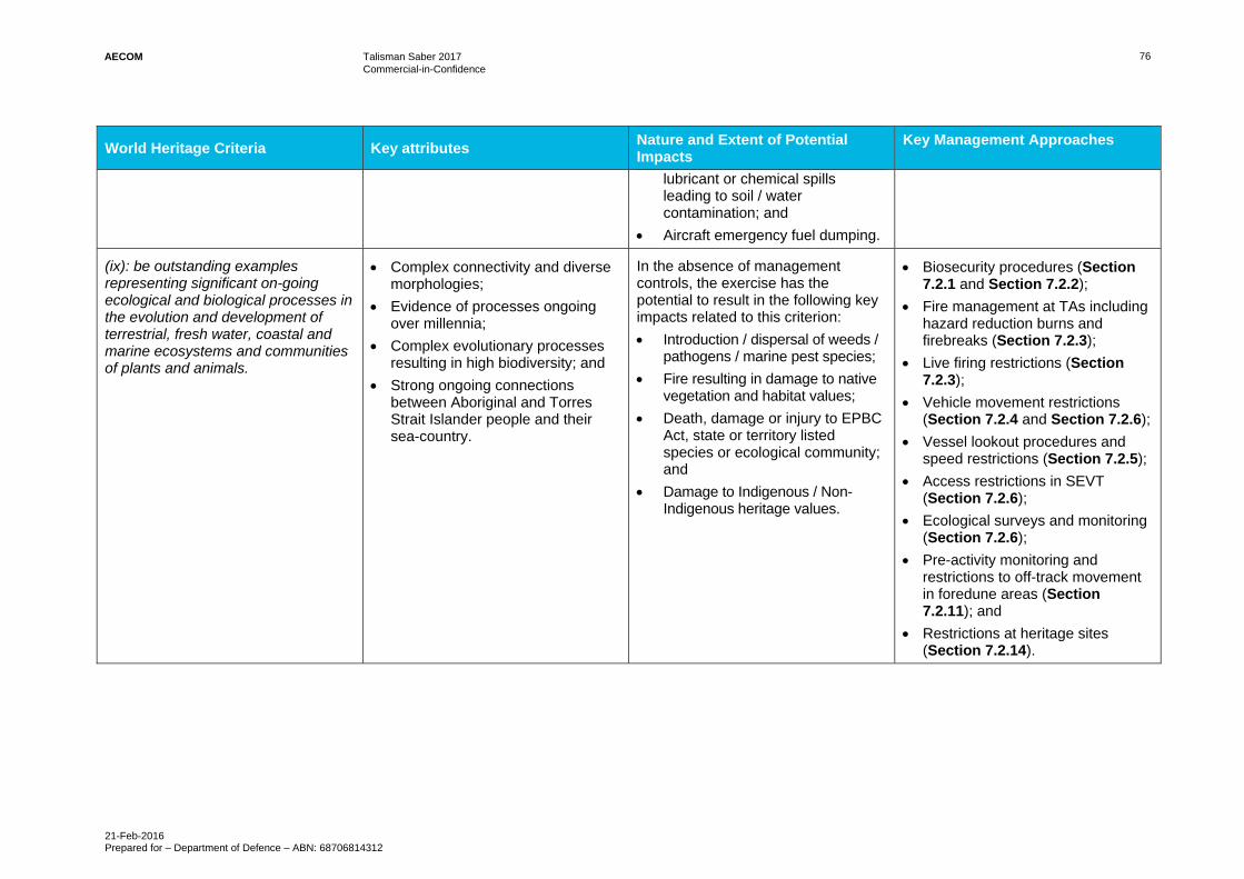
AECOM Talisman Saber 2017 Commercial-in-Confidence
21-Feb-2016 Prepared for – Department of Defence – ABN: 68706814312
76
World Heritage Criteria Key attributes Nature and Extent of Potential Impacts
Key Management Approaches
lubricant or chemical spills leading to soil / water contamination; and
Aircraft emergency fuel dumping.
(ix): be outstanding examples representing significant on-going ecological and biological processes in the evolution and development of terrestrial, fresh water, coastal and marine ecosystems and communities of plants and animals.
Complex connectivity and diverse morphologies;
Evidence of processes ongoing over millennia;
Complex evolutionary processes resulting in high biodiversity; and
Strong ongoing connections between Aboriginal and Torres Strait Islander people and their sea-country.
In the absence of management controls, the exercise has the potential to result in the following key impacts related to this criterion:
Introduction / dispersal of weeds / pathogens / marine pest species;
Fire resulting in damage to native vegetation and habitat values;
Death, damage or injury to EPBC Act, state or territory listed species or ecological community; and
Damage to Indigenous / Non-Indigenous heritage values.
Biosecurity procedures (Section 7.2.1 and Section 7.2.2);
Fire management at TAs including hazard reduction burns and firebreaks (Section 7.2.3);
Live firing restrictions (Section 7.2.3);
Vehicle movement restrictions (Section 7.2.4 and Section 7.2.6);
Vessel lookout procedures and speed restrictions (Section 7.2.5);
Access restrictions in SEVT (Section 7.2.6);
Ecological surveys and monitoring (Section 7.2.6);
Pre-activity monitoring and restrictions to off-track movement in foredune areas (Section 7.2.11); and
Restrictions at heritage sites (Section 7.2.14).
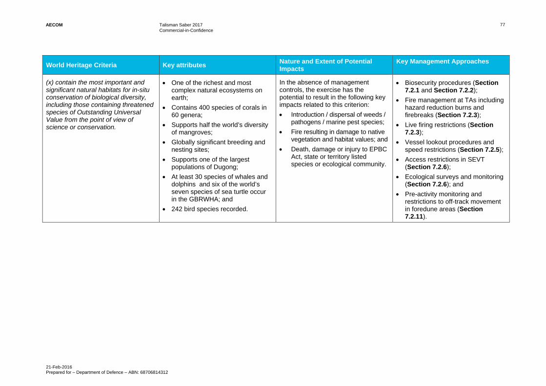
AECOM Talisman Saber 2017 Commercial-in-Confidence
21-Feb-2016 Prepared for – Department of Defence – ABN: 68706814312
77
World Heritage Criteria Key attributes Nature and Extent of Potential Impacts
Key Management Approaches
(x) contain the most important and significant natural habitats for in-situ conservation of biological diversity, including those containing threatened species of Outstanding Universal Value from the point of view of science or conservation.
One of the richest and most complex natural ecosystems on earth;
Contains 400 species of corals in 60 genera;
Supports half the world’s diversity of mangroves;
Globally significant breeding and nesting sites;
Supports one of the largest populations of Dugong;
At least 30 species of whales and dolphins and six of the world’s seven species of sea turtle occur in the GBRWHA; and
242 bird species recorded.
In the absence of management controls, the exercise has the potential to result in the following key impacts related to this criterion:
Introduction / dispersal of weeds / pathogens / marine pest species;
Fire resulting in damage to native vegetation and habitat values; and
Death, damage or injury to EPBC Act, state or territory listed species or ecological community.
Biosecurity procedures (Section 7.2.1 and Section 7.2.2);
Fire management at TAs including hazard reduction burns and firebreaks (Section 7.2.3);
Live firing restrictions (Section 7.2.3);
Vessel lookout procedures and speed restrictions (Section 7.2.5);
Access restrictions in SEVT (Section 7.2.6);
Ecological surveys and monitoring (Section 7.2.6); and
Pre-activity monitoring and restrictions to off-track movement in foredune areas (Section 7.2.11).
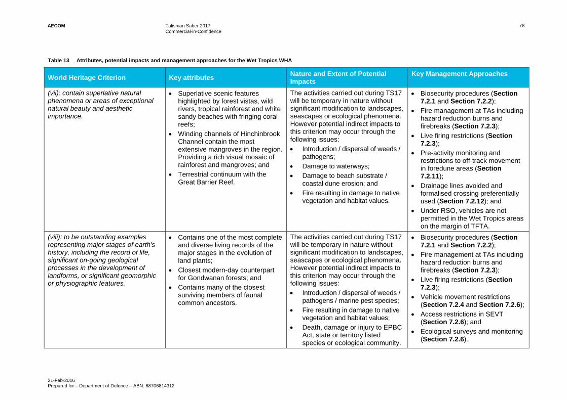
AECOM Talisman Saber 2017 Commercial-in-Confidence
21-Feb-2016 Prepared for – Department of Defence – ABN: 68706814312
78
Table 13 Attributes, potential impacts and management approaches for the Wet Tropics WHA
World Heritage Criterion Key attributes Nature and Extent of Potential Impacts
Key Management Approaches
(vii): contain superlative natural phenomena or areas of exceptional natural beauty and aesthetic importance.
Superlative scenic features highlighted by forest vistas, wild rivers, tropical rainforest and white sandy beaches with fringing coral reefs;
Winding channels of Hinchinbrook Channel contain the most extensive mangroves in the region. Providing a rich visual mosaic of rainforest and mangroves; and
Terrestrial continuum with the Great Barrier Reef.
The activities carried out during TS17 will be temporary in nature without significant modification to landscapes, seascapes or ecological phenomena. However potential indirect impacts to this criterion may occur through the following issues:
Introduction / dispersal of weeds / pathogens;
Damage to waterways;
Damage to beach substrate / coastal dune erosion; and
Fire resulting in damage to native vegetation and habitat values.
Biosecurity procedures (Section 7.2.1 and Section 7.2.2);
Fire management at TAs including hazard reduction burns and firebreaks (Section 7.2.3);
Live firing restrictions (Section 7.2.3);
Pre-activity monitoring and restrictions to off-track movement in foredune areas (Section 7.2.11);
Drainage lines avoided and formalised crossing preferentially used (Section 7.2.12); and
Under RSO, vehicles are not permitted in the Wet Tropics areas on the margin of TFTA.
(viii): to be outstanding examples representing major stages of earth's history, including the record of life, significant on-going geological processes in the development of landforms, or significant geomorphic or physiographic features.
Contains one of the most complete and diverse living records of the major stages in the evolution of land plants;
Closest modern-day counterpart for Gondwanan forests; and
Contains many of the closest surviving members of faunal common ancestors.
The activities carried out during TS17 will be temporary in nature without significant modification to landscapes, seascapes or ecological phenomena. However potential indirect impacts to this criterion may occur through the following issues:
Introduction / dispersal of weeds / pathogens / marine pest species;
Fire resulting in damage to native vegetation and habitat values;
Death, damage or injury to EPBC Act, state or territory listed species or ecological community.
Biosecurity procedures (Section 7.2.1 and Section 7.2.2);
Fire management at TAs including hazard reduction burns and firebreaks (Section 7.2.3);
Live firing restrictions (Section 7.2.3);
Vehicle movement restrictions (Section 7.2.4 and Section 7.2.6);
Access restrictions in SEVT (Section 7.2.6); and
Ecological surveys and monitoring (Section 7.2.6).

AECOM Talisman Saber 2017 Commercial-in-Confidence
21-Feb-2016 Prepared for – Department of Defence – ABN: 68706814312
79
World Heritage Criterion Key attributes Nature and Extent of Potential Impacts
Key Management Approaches
(ix): be outstanding examples representing significant on-going ecological and biological processes in the evolution and development of terrestrial, fresh water, coastal and marine ecosystems and communities of plants and animals.
Outstanding examples of significant ongoing ecological processes and biological evolution;
Centre of endemism second only to New Caledonia in endemic genera density;
Provides fundamental insights into ecological processes and the evolution from rainforest to sclerophyll forests; and
Exceptionally high level of fauna and flora diversity with 3,000 vascular plant species, of which 576 are endemic, 107 mammal species, of which 11 are endemic, 113 reptile species, of which 24 are endemic and 51 amphibians, of which 22 are endemic.
The activities carried out during TS17 will be temporary in nature without significant modification to landscapes, seascapes or ecological phenomena. However potential indirect impacts to this criteria may occur through the following issues:
Introduction / dispersal of weeds / pathogens / marine pest species;
Fire resulting in damage to native vegetation and habitat values;
Death, damage or injury to EPBC Act, state or territory listed species or ecological community.
Biosecurity procedures (Section 7.2.1 and Section 7.2.2);
Fire management at TAs including hazard reduction burns and firebreaks (Section 7.2.3);
Live firing restrictions (Section 7.2.3);
Vehicle movement restrictions (Section 7.2.4 and Section 7.2.6);
Access restrictions in SEVT (Section 7.2.6); and
Ecological surveys and monitoring (Section 7.2.6).
(x): contain the most important and significant natural habitats for in-situ conservation of biological diversity, including those containing threatened species of Outstanding Universal Value from the point of view of science or conservation.
Largely intact with hundreds of endemic species, many listed as threatened;
Majority of plant species have restricted distributions and many plant and animal species are isolated or are disjunct populations; and
Most floristically and structurally diverse in Australia and outstanding on a global scale.
The activities carried out during TS17 will be temporary in nature without significant modification to landscapes, seascapes or ecological phenomena. However potential indirect impacts to this criterion may occur through the following issues:
Introduction / dispersal of weeds / pathogens / marine pest species;
Fire resulting in damage to native vegetation and habitat values;
Death, damage or injury to EPBC Act, state or territory listed species or ecological community.
Biosecurity procedures (Section 7.2.1 and Section 7.2.2);
Fire management at TAs including hazard reduction burns and firebreaks (Section 7.2.3);
Live firing restrictions (Section 7.2.3);
Vehicle movement restrictions (Section 7.2.4 and Section 7.2.6);
Access restrictions in SEVT (Section 7.2.6); and
Ecological surveys and monitoring (Section 7.2.6).

AECOM Talisman Saber 2017 Commercial-in-Confidence
21-Feb-2016 Prepared for – Department of Defence – ABN: 68706814312
80
Table 14 Attributes, potential impacts and management approaches for Kakadu WHA
World Heritage Criteria Key attributes Nature and Extent of Potential Impacts
Key Management Approaches
(i): to represent a masterpiece of human creative genius.
Art sites represent a unique artistic achievement;
Large number and density of art sites; and
Detailed depictions of people and animal species, many long extinct.
MBTA is spatially separated from Kakadu WHA and potential impacts from activities are unlikely to result in changes to art sites, particularly those that are not within the immediate vicinity of the TS17 activity. However, heritage sites at MBTA contribute to the overall heritage value of the region.
Restrictions at heritage sites (Section 7.2.14).
(vi): to be directly or tangibly associated with events or living traditions, with ideas, or with beliefs, with artistic and literary works of outstanding universal significance.
Rock art and archaeological records are an exceptional source of evidence for social and ritual activities from Pleistocene era to present.
MBTA is spatially separated from Kakadu WHA and potential impacts from activities are unlikely to result in changes to art sites, particularly those that are not within the immediate vicinity of the TS17 activity. However, heritage sites at MBTA contribute to the overall heritage value of the region.
Restrictions at heritage sites (Section 7.2.14).
(vii): contain superlative natural phenomena or areas of exceptional natural beauty and aesthetic importance.
Contrast between Ramsar wetlands and spectacular vertical and stepped escarpments;
Wetlands extend over tens of square kilometres and host millions of waterbirds;
Large areas without human access; and
Breathtaking views.
TS17 activities will not take place within the WHA and are unlikely to result in impacts to Ramsar wetlands, escarpments or views of the WHA. However potential indirect impacts to this criterion may occur through the following indirect issues:
Weed and feral animal invasion; and
Wildfire.
Biosecurity procedures (Section 7.2.1 and Section 7.2.2);
Fire management at TAs including hazard reduction burns and firebreaks (Section 7.2.3);
Live firing restrictions (Section 7.2.3); and
Restriction of live firing to designated target areas to ensure the risk of fire is reduced.

AECOM Talisman Saber 2017 Commercial-in-Confidence
21-Feb-2016 Prepared for – Department of Defence – ABN: 68706814312
81
World Heritage Criteria Key attributes Nature and Extent of Potential Impacts
Key Management Approaches
(ix): be outstanding examples representing significant on-going ecological and biological processes in the evolution and development of terrestrial, fresh water, coastal and marine ecosystems and communities of plants and animals.
Incorporates significant elements of four major river systems;
Escarpment and stone country span more than 2 billion years of geological history;
Floodplains dynamic environments which illustrate ecological and geomorphological effects of Holocene climate change and sea-level rise;
Relatively little impact from human settlement over a large area providing unique opportunity to investigate large-scale processes in intact landscape; and
Indigenous communities, rock art and archaeological sites represent an outstanding example of human interaction with the environment.
MBTA is not located within the Kakadu WHA so TS17 activities are unlikely to directly impact on the values of the WHA. The activities carried out during TS17 are temporary in nature and are unlikely to modify landscapes, floodplains, river systems or heritage sites. However, potential impacts to this criterion may occur through the following secondary issues: Weed and feral animal invasion; Wildfire; and Land and water contamination.
Biosecurity procedures (Section 7.2.1 and Section 7.2.2);
Restriction of TS17 activities to MBTA and other Defence sites which are spatially separated from the Kakadu WHA;
Restrictions at heritage sites (Section 7.2.14).
Vehicle movement restrictions (Section 7.2.4 and Section 7.2.6); and
Live firing restrictions (Section 7.2.3).
(x): contain the most important and significant natural habitats for in-situ conservation of biological diversity, including those containing threatened species of Outstanding Universal Value from the point of view of science or conservation.
Protects almost entire catchment of a large tropical river;
Widest range of habitats and greatest number of species documented of any comparable area in tropical northern Australia; and
Protects over one third of Australia’s bird species, one quarter of Australia’s land mammals and an exceptionally high number of reptile, frog and fish species as well as huge concentrations of waterbirds.
MBTA is not located within the Kakadu WHA so TS17 activities are unlikely to directly impact on the values of the WHA. The activities carried out during TS17 are temporary in nature and are unlikely to impact on the biological diversity or the range of habitats within the WHA. However potential impacts to this criterion may occur through the following secondary issues: Weed and feral animal invasion; Wildfire; and Land and water contamination
Biosecurity procedures (Section 7.2.1 and Section 7.2.2);
Restriction of TS17 activities to MBTA and other Defence sites which are spatially separated from the Kakadu WHA;
Vehicle movement restrictions (Section 7.2.4 and Section 7.2.6); and
Live firing restrictions (Section 7.2.3).

AECOM Talisman Saber 2017 Commercial-in-Confidence
21-Feb-2016 Prepared for – Department of Defence – ABN: 68706814312
82
Table 15 Significant Impact Assessment – World Heritage Areas
Criterion Assessment of nature and extent of impacts
Possibility the action will cause one or more of the World Heritage attributes to be lost.
Unlikely.
The action is unlikely to result in the loss of the WHA’s natural beauty, the ecosystems, the morphology, evidence of morphology, the size, the diversity or elements that are essential for the long-term conservation of the area’s ecosystems and biodiversity as the activity is short term and has a limited spatial distribution. The activity will be physically separated from sensitive environmental areas through the use of restricted areas and operational controls will limit impacts. The overall scale and intensity of TS17 is expected to be similar to previous years and any impacts are likely to be localised, temporary and recoverable.
Possibility the action will cause one or more of the World Heritage attributes to be degraded or damaged.
Unlikely.
Impacts from TS17 are expected to be localised, temporary and recoverable due to the short duration and limited spatial distribution of the activity. Standard Defence controls such as RSOs and buffer zones, Exercise-specific controls such as the TS17 EMP, and Defence’s collaborative management with relevant authorities and the limitation of impacts from previous Exercises show that TS17 may involve limited, temporary impact on components of the ecosystem although this will not impact on the ecosystem as a whole or affect World Heritage values. TS17 is unlikely to result in the loss of the WHA’s natural beauty, the ecosystems, the morphology, evidence of morphology, the size, the diversity or elements that are essential for the long-term conservation of the area’s ecosystems and biodiversity.
Possibility the action will cause one or more of the World Heritage attributes to be notably altered, modified, obscured or diminished.
Unlikely.
The action is unlikely to cause any notable alterations, modifications, obscuring or diminishments in the WHA’s size, diversity, natural beauty, ecosystem as a whole, morphology, evidence of morphology or elements that are essential for the long-term conservation of the area’s ecosystems and biodiversity as the activity is short term and has a limited spatial distribution. The activity will be physically separated from sensitive environmental areas through the use of restricted areas and operational controls will limit impacts.
Possibility the action will impact on the integrity of the property
Unlikely
The TS17 activities will be physically separated from sensitive environmental areas through the use of restrictions and operational control to limit impacts. In addition, the activity is similar to previous Talisman Saber activities previously undertaken at the sites which did not impact on the World Heritage values of the sites. TS17 impacts will be localised, temporary and recoverable. The action is unlikely to result in an impact to, or loss of, any elements or features and processes that convey the properties’ Outstanding Universal Values or are necessary for the WHA properties to maintain their Outstanding Universal Values. It is also unlikely to reduce the size or change the boundary of the properties, or otherwise reduce the wholeness of the WHAs. In addition, the action is unlikely to impact on the intactness of the WHA sites and is unlikely to result in fragmentation, loss or degradation of the key features, processes and attributes of the World Heritage values of the sites.

AECOM Talisman Saber 2017 Commercial-in-Confidence
21-Feb-2016 Prepared for – Department of Defence – ABN: 68706814312
83
National Heritage places 8.1.2
National Heritage sites are sites of natural, historic and Indigenous places of outstanding significance to the nation.
Description
All of the main training areas where TS17 will occur (SWBTA, TFTA, CBTA and MBTA) contain National Heritage listed sites. For the most part, these sites remain in good condition because they have been in Defence ownership for many years and Defence has been a conscientious steward of heritage values.
Management
Defence manages its impacts on the heritage values of these sites through:
Heritage management forming a key part of site EMPs for HBTA and TFTA;
Creation of exclusion zones around key heritage sites to limit the type of training activities that can be conducted in the vicinity of these sites. This is particularly the case for high intensity training such as live firing or explosive demolitions training; and with heavy vehicle use at MBTA and TFTA (used at both sites but mostly in buffer zones to ensure the sites remain in a natural condition); and
Inclusion of measures into standard and regularly used military doctrine such as RSOs, as well as through Environmental Awareness Cards for SWBTA and TFTA.
Chapter 3 of the State of Environment Report for SWBTA demonstrates that the heritage values of the property have been well cared for under the site’s EMS (Defence 2008). Similar provisions (e.g. Heritage Environment Management Plans (HEMPs) for MBTA and RSOs for the other major training areas) provide robust protection for National Heritage Places during TS17.
Nature and extent of likely impact
The activities that will be undertaken for TS17 will be consistent with activities that are routinely undertaken at CBTA, MBTA and SWBTA and these activities are described and managed through the RSOs for these sites. The activities at Stanage Bay will be undertaken in accordance with the NDTA SOs developed specifically for the management of Defence activities on non-Defence lands. The potential for activities (both on and off Defence-owned land) to impact on water quality (such as through sedimentation of watercourses and disturbance of the littoral zone) are specifically addressed by RSOs and exercise EMPs. Further to this, any risks to natural heritage values will be managed through implementation of the additional mitigation measures identified in Section 7.2.14 – Heritage Management, and Section 7.2.6 – Endangered Ecological Communities and Sensitive Habitats. In addition, TS17 is a short-term activity with a limited spatial distribution.
Based on the Significant Impact Assessment in Table 16, it is unlikely that TS17 will result in a significant impact on National Heritage properties.
Table 16 Significant Impact Assessment - National Heritage places
Criterion Assessment of nature and extent of impacts
Possibility the action will cause one or more of the National Heritage attributes to be lost.
Unlikely.
The overall scale and intensity of TS17 is expected to be similar to previous years; any impacts would be localised, temporary and recoverable. Existing exclusion zones and other heritage management measures will remain extant for the activity and additional measures will be implemented to further reduce potential impacts.
Possibility the action will cause one or more of the National Heritage attributes to be degraded or damaged.
Unlikely.
Impacts from TS17 are expected to be localised, temporary and recoverable. Existing exclusion zones and other heritage management measures will remain extant for the activity and additional measures will be implemented to further reduce potential impacts. When considered in the context of these controls, it is considered unlikely that TS17 will result in degradation or damage of any National Heritage values.

AECOM Talisman Saber 2017 Commercial-in-Confidence
21-Feb-2016 Prepared for – Department of Defence – ABN: 68706814312
84
Criterion Assessment of nature and extent of impacts
Possibility the action will cause one or more of the National Heritage attributes to be notably altered, modified, obscured or diminished.
Unlikely.
Impacts from TS17 are expected to be localised, temporary and recoverable. Existing exclusion zones and other heritage management measures will remain extant for the activity and additional measures will be implemented to further reduce potential impacts When considered in the context of these controls, it is considered unlikely that TS17 will result in degradation or damage of any National Heritage values.
Possibility the action will impact on the integrity of the property.
Unlikely.
The TS17 activities will be physically separated from sensitive environmental areas through the use of restrictions and operational control to limit impacts. In addition, the activity is similar to Talisman Saber activities previously undertaken at the sites which did not significantly impact on the National Heritage values of the sites. TS17 impacts will be localised, temporary and recoverable. The action is unlikely to result in an impact to, or loss of, any elements or features and processes that convey the properties’ heritage values or are necessary for the properties to maintain their National Heritage Values. It is also unlikely to reduce the size or change the boundary of the properties, or otherwise reduce the wholeness of the National Heritage areas. In addition, the action is unlikely to impact on the intactness of the National Heritage sites and is unlikely to result in fragmentation, loss or degradation of the key features, processes and attributes of the National Heritage values of the sites.
Wetlands of International Importance 8.1.3
Wetlands of International Importance (Ramsar sites) are classified as such if a wetland is internationally significant in terms of the biodiversity and uniqueness of ecology, botany, zoology, limnology or hydrology.
The TS17 Exercise will take place in the vicinity of five wetlands of international importance (Ramsar sites):
‘Shoalwater and Corio Bays’, which extends into SWBTA, meet criteria one to eight for a Ramsar site;
‘Kakadu National Park’, adjacent to MBTA, meets all nine criteria for a Ramsar wetland site;
‘Coral Sea Reserves (Coringa-Herald and Lihou Reefs and Cays)’ in the Coral Sea meets Ramsar criteria one to five, seven and eight; and
‘Cobourg Peninsula and Ashmore Reef National Nature Reserve’, in the Timor and Arafura Sea, meets the first six criteria of a Ramsar wetland site.
The natural values and processes for each criterion that have contributed to the listing of each of these sites are provided in Appendix X and Table 17 provides the Significant Impact Assessment for these sites.
Management
Defence manages its impacts on these Ramsar sites through:
Close consultation and cooperation with GBRMPA and State government maritime and nature conservation authorities;
Oil spill preparedness measures;
Prohibition on discharge of sewage and other ship wastes in the vicinity of the Shoalwater and Corio Bays area;
Biosecurity measures to prevent the introduction and spread of possible marine pests;

AECOM Talisman Saber 2017 Commercial-in-Confidence
21-Feb-2016 Prepared for – Department of Defence – ABN: 68706814312
85
Regulation of inshore activities involving watercraft, amphibious vehicles and beach landings to minimise disturbance to wildlife and prevent damage to seagrass, saltmarsh and mangroves;
Restriction on off-road vehicle movement in Dismal Sector of SWBTA where part of the RAMSAR wetland is located, and restrictions on off-road vehicle movement in the vicinity of freshwater wetlands; and
The Maritime activities EMP provides detailed guidance on the minimisation of environmental impacts of naval activities in the Timor and Arafura Seas, Coral Sea and in the vicinity of other marine Ramsar sites.
Nature and extent of impacts
The impacts from TS17 on the Ramsar sites in the vicinity of the Exercise activities will be limited due to the short duration and limited spatial distribution of the activity. In addition, the activities that will be undertaken for TS17 will be consistent with activities that are routinely undertaken at CBTA and MBTA and these activities are described and managed through the RSOs and EMPs for these sites. Further to this, potential impacts will be subject to additional mitigation measures including those identified in Section 7.2.6 – Endangered Ecological Communities and Sensitive Habitats, and Section 7.2.12 – Watercourses, Section 7.2.15 - Land and Water Contamination.
Based on the Significant Impact Assessment in Table 17, it is unlikely that TS17 will result in a significant impact on World Heritage properties
Table 17 Significant Impact Assessment - Wetlands of International Importance
Criterion Assessment of nature and extent of impacts
Possibility the action will result in areas of the wetland being destroyed or substantially modified.
Unlikely.
Most TS17 activities will take place well away from three of the four Ramsar sites described above and are not likely to have any notable impacts. At SWBTA, environmental management arrangements for military activities are well established and regularly reviewed in conjunction with conservation authorities. The GBR Strategic Assessment report determined that Defence activities are localised, appropriately managed and the condition and trend for MNES is considered to be good and stable. The ecological character of Shoalwater Bay Wetlands has been well conserved in conjunction with major military exercises for nearly half a century.
The condition of the Ramsar sites that TS17 will interact with has been assessed with recognition of the continuing nature of TS17. The Report found that these sites are in a good condition at present and it is predicted they will remain stable and improve over time (GBRMPA 2014). When considered in the context of the mitigation measures and the short duration of the Exercise, TS17 is unlikely to result in areas of Wetlands of National Importance being destroyed or substantially modified.
Possibility the action will result in a substantial and measurable change in the hydrological regime of the wetland, for example, a substantial change to the volume, timing, duration and frequency of ground and surface water flows to and within the wetland.
Unlikely.
For the reasons described for the criterion above, TS17 is unlikely to result in a substantial and measurable change in the hydrological regime of the Ramsar sites.
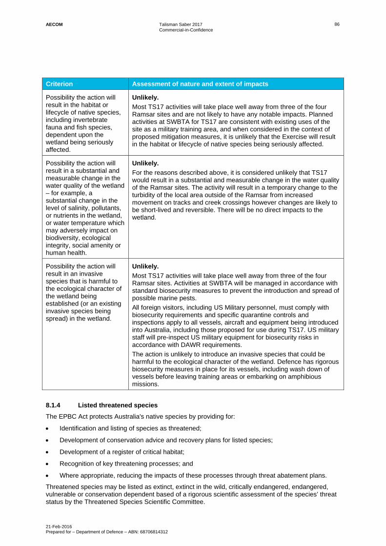
AECOM Talisman Saber 2017 Commercial-in-Confidence
21-Feb-2016 Prepared for – Department of Defence – ABN: 68706814312
86
Criterion Assessment of nature and extent of impacts
Possibility the action will result in the habitat or lifecycle of native species, including invertebrate fauna and fish species, dependent upon the wetland being seriously affected.
Unlikely.
Most TS17 activities will take place well away from three of the four Ramsar sites and are not likely to have any notable impacts. Planned activities at SWBTA for TS17 are consistent with existing uses of the site as a military training area, and when considered in the context of proposed mitigation measures, it is unlikely that the Exercise will result in the habitat or lifecycle of native species being seriously affected.
Possibility the action will result in a substantial and measurable change in the water quality of the wetland – for example, a substantial change in the level of salinity, pollutants, or nutrients in the wetland, or water temperature which may adversely impact on biodiversity, ecological integrity, social amenity or human health.
Unlikely.
For the reasons described above, it is considered unlikely that TS17 would result in a substantial and measurable change in the water quality of the Ramsar sites. The activity will result in a temporary change to the turbidity of the local area outside of the Ramsar from increased movement on tracks and creek crossings however changes are likely to be short-lived and reversible. There will be no direct impacts to the wetland.
Possibility the action will result in an invasive species that is harmful to the ecological character of the wetland being established (or an existing invasive species being spread) in the wetland.
Unlikely.
Most TS17 activities will take place well away from three of the four Ramsar sites. Activities at SWBTA will be managed in accordance with standard biosecurity measures to prevent the introduction and spread of possible marine pests.
All foreign visitors, including US Military personnel, must comply with biosecurity requirements and specific quarantine controls and inspections apply to all vessels, aircraft and equipment being introduced into Australia, including those proposed for use during TS17. US military staff will pre-inspect US military equipment for biosecurity risks in accordance with DAWR requirements.
The action is unlikely to introduce an invasive species that could be harmful to the ecological character of the wetland. Defence has rigorous biosecurity measures in place for its vessels, including wash down of vessels before leaving training areas or embarking on amphibious missions.
Listed threatened species 8.1.4
The EPBC Act protects Australia's native species by providing for:
Identification and listing of species as threatened;
Development of conservation advice and recovery plans for listed species;
Development of a register of critical habitat;
Recognition of key threatening processes; and
Where appropriate, reducing the impacts of these processes through threat abatement plans.
Threatened species may be listed as extinct, extinct in the wild, critically endangered, endangered, vulnerable or conservation dependent based of a rigorous scientific assessment of the species’ threat status by the Threatened Species Scientific Committee.

AECOM Talisman Saber 2017 Commercial-in-Confidence
21-Feb-2016 Prepared for – Department of Defence – ABN: 68706814312
87
Description
The areas where TS17 will be undertaken have the potential to contain a number of threatened species listed under the EPBC Act. All of the species that were identified through the EPBC Act PMST searches (see Appendix F to Appendix M) and available survey data are listed in Appendix N along with an assessment of the likelihood that the species will be present at the TS17 sites. The assessment showed that 67 threatened species have an occurrence likelihood of moderate or greater at the TS17 sites. The classes and listing status of these species is shown in Table 18.
Table 18 Threatened species with a moderate or greater likelihood of occurrence at TS17 sites
Critically Endangered Endangered Vulnerable
Mammal - 6 13
Plant - 4 5
Bird 4 11 11
Fish - - 1
Reptile - 6 15
Amphibian - 1 -
Sharks and Rays - - -
Management
TS17 is occurring over a short timeframe and does not propose any permanent changes to landscapes or habitats. In addition, Defence has a comprehensive framework for managing the environment on training areas and in marine areas and is implementing additional mitigation measures to reduce impacts to protected species (see Section 7.2). Standard and additional measures include:
Exclusion zones to be placed around areas known to contain protected species or endangered ecological communities;
Restriction of off-road vehicle movements;
Restriction of vegetation clearing and major excavations likely to impact habitat or species distribution; and
Reinstatement of disturbed areas after the Exercise has concluded.
Nature and Extent of Likely Impacts
The critically endangered species with an occurrence likelihood of moderate or greater at the TS17 sites include 4 bird species. A significant impact assessment for these species can be found in Table 19. This table is a summary and analysis of the likely impacts from TS17 for all the species with a likelihood of occurrence of moderate or greater. The detail of interactions of TS17 with each species and the nature and extent of impacts can be found in Appendix Z.
The endangered species with an occurrence likelihood of moderate or greater at the TS17 sites include 11 bird species, 6 mammal, 4 plant, 6 reptile and 1 amphibian species. A significant impact assessment for these species can be found in Table 19. This table is a summary and analysis of the likely impacts from TS17 for all the species with a likelihood of occurrence of moderate or greater. The detail of interactions of TS17 with each species and the nature and extent of impacts can be found in Appendix AA.
The vulnerable species with an occurrence likelihood of moderate or greater at the TS17 sites include 11 bird species, 13 mammal, 5 plant, 15 reptile and 1 fish species. A significant impact assessment for these species can be found in Table 19. This table is a summary and analysis of the likely impacts from TS17 for all the species with a likelihood of occurrence of moderate or greater. The detail of interactions of TS17 with each species and the nature and extent of impacts can be found in Appendix Z.
AECOM Talisman Saber 2017 Commercial-in-Confidence
21-Feb-2016 Prepared for – Department of Defence – ABN: 68706814312
88
Table 19 Significant Impact Assessment – Critically Endangered, Endangered and Vulnerable Species
Criterion Assessment of nature and extent of impacts
Critically Endangered & Endangered Species
Possibility the action will lead to a long-term decrease in the size of a population.
Vulnerable Species
Possibility the action will lead to a long-term decrease in the size of an important population of a species.
Unlikely.
The activities proposed for TS17 are the same short-term uses of these training areas that occur during routine training year-round. Major earthworks, substantial vegetation clearance or other actions that might change hydrological regimes or otherwise impact habitat are not proposed and are prohibited without environmental assessments and specific control from Range Control or the EMG. Areas of ground disturbance may occur as part of the activities, however these will be focused in areas that have been previously cleared, or retain limited native species, and / or are sparsely vegetated. It is unlikely that TS17 will result in permanent or major impacts to habitat that supports critically endangered or endangered species, or important populations of vulnerable species. It is also unlikely that TS17 will impact on the breeding cycle of the listed critically endangered or endangered species, or an important population of vulnerable species, therefore it is unlikely that impacts will be significant.
In the unlikely event that there were impacts to a population of critically endangered or endangered species, or an important population of vulnerable species, they would likely be minor, localised and temporary.
Critically Endangered & Endangered Species
Possibility the action will reduce the area of occupancy of the species.
Vulnerable Species
Possibility the action will reduce the area of occupancy of an important population.
Unlikely.
The activities proposed for TS17 are the same short-term uses of these training areas that occur during routine training year-round. Major earthworks, substantial vegetation clearance or other actions that might change hydrological regimes or otherwise impact habitat are not proposed and are prohibited without environmental assessments and specific control from Range Control or the EMG. Areas of ground disturbance may occur as part of the activities, however these will be focused in areas that have been previously cleared, or retain limited native species, and / or are sparsely vegetated. Areas that are inadvertently disturbed in sensitive areas will be remediated following the Exercise.
In the unlikely event that there were impacts they would likely be minor, localised and temporary and would be unlikely to reduce the area of occupancy the species.
Critically Endangered & Endangered Species
Possibility the action will fragment an existing population into two or more populations.
Vulnerable Species
Possibility the action will fragment an existing important population into two or more populations.
Unlikely.
The activities proposed for TS17 are the same short-term uses of training areas that occur during routine training year-round. Known populations of threatened species will be avoided where possible in accordance with RSOs and any inadvertent impacts are likely to be temporary and reversible and are unlikely to result in the fragmentation of critically endangered or endangered species populations, or important vulnerable species populations.
AECOM Talisman Saber 2017 Commercial-in-Confidence
21-Feb-2016 Prepared for – Department of Defence – ABN: 68706814312
89
Criterion Assessment of nature and extent of impacts
Critically Endangered, Endangered & Vulnerable Species
Possibility the action will adversely affect habitat critical to the survival of a species.
Unlikely.
The activities proposed for TS17 are the same short-term uses of these training areas that occur during routine training year-round. Impacts to habitat known to support threatened species will be avoided where possible in accordance with RSOs and impacts are likely to be minor, localised and temporary. Major earthworks, substantial vegetation clearance or other actions that might change hydrological regimes or otherwise impact habitat are not proposed and are prohibited without environmental assessments and specific control from Range Control or the EMG. Areas of ground disturbance may occur as part of the activities, however these will be focused in areas that have been previously cleared, or retain limited native species, and / or are sparsely vegetated. Areas that are inadvertently disturbed in sensitive areas will be remediated following the Exercise.
In the unlikely event that there were impacts they would likely be minor, localised and temporary and would be unlikely to reduce the area of occupancy the species.
Critically Endangered & Endangered Species
Possibility the action will disrupt the breeding cycle of a population.
Vulnerable Species
Possibility the action will disrupt the breeding cycle of an important population
Unlikely.
TS17 is intended to be conducted in June - July 2017 which is not during peak bird, mammal, turtle or plant breeding or reproduction seasons of the listed species identified from the PMST search.
Critically Endangered, Endangered & Vulnerable Species
Possibility the action will modify, destroy, remove, isolate or decrease the availability or quality of habitat to the extent that the species is likely to decline.
Unlikely.
The activities proposed for TS17 are the same short-term uses of these training areas that occur during routine training year-round. Impacts to habitat known to support threatened species will be avoided where possible in accordance with RSOs and impacts are likely to be minor, localised and temporary. Major earthworks, substantial vegetation clearance or other actions that might change hydrological regimes or otherwise impact habitat are not proposed and are prohibited without environmental assessments and specific control from Range Control or the EMG. Areas of ground disturbance may occur as part of the activities, however these will be focused in areas that have been previously cleared, or retain limited native species, and / or are sparsely vegetated. Areas that are inadvertently disturbed in sensitive areas will be remediated following the Exercise or during the Exercise, depending on the severity of disturbance. While beach landing exercises have the potential to result in localised impacts to seagrass and coral reef habitats present at shallow depths, the level of disturbance to these habitats is insufficient to result in species decline and will be further minimised through adherence to operational controls to avoid or minimise loss of these habitat elements (Umwelt 2017).
In the unlikely event that there were impacts they would likely be minor, localised and temporary and would be unlikely to reduce the area of occupancy the species.

AECOM Talisman Saber 2017 Commercial-in-Confidence
21-Feb-2016 Prepared for – Department of Defence – ABN: 68706814312
90
Criterion Assessment of nature and extent of impacts
Critically Endangered & Endangered Species
Possibility the action will result in invasive species that are harmful to a critically endangered, endangered or vulnerable species’ becoming established in the critically endangered, endangered or vulnerable species’ habitat.
Unlikely.
The risk of introduction or dispersal of an invasive species or disease will be managed through prevention activities and control activities. Defence standard quarantine processes including inspections of military equipment in accordance with DAWR requirements prior to arrival in Australia, establishment and use of wash-down facilities at entry points to Training Areas and maritime monitoring, including monitoring of wastewater discharge, as well as mitigation measures in Section 7.0.
It is unlikely that TS17 will result in the introduction or dispersal of an invasive species considering these mitigation measures and in comparison to standard commercial equipment movement across the Australian border.
Critically Endangered, Endangered & Vulnerable Species
Possibility the action will introduce a disease that may cause the species to decline.
Critically Endangered, Endangered & Vulnerable Species
Possibility the action will interfere with the recovery of the species.
Unlikely.
TS17 activities are unlikely to result in permanent or widespread impacts to habitat that supports protected species. No large-scale vegetation clearing, major excavations or other activities that are considered key threatening processes under species recovery plans (see Appendix D) are planned for the activity. The activities proposed for TS17 are the same short-term uses of these training areas that occur during routine training year-round. Impacts to habitat known to support threatened species will be avoided where possible in accordance with RSOs and impacts are likely to be minor, localised and temporary. Areas of ground disturbance may occur as part of the activities, however these will be focused in areas that have been previously cleared, or retain limited native species, and / or are sparsely vegetated. Areas that are inadvertently disturbed in sensitive areas will be remediated following the Exercise or during the Exercise, depending on the severity of disturbance.
In the unlikely event that there were impacts they would likely be minor, localised and temporary and would be unlikely to reduce the area of occupancy the species.
Listed threatened ecological communities 8.1.5
An ecological community is a naturally occurring group of native plants, animals and other organisms that are interacting in a unique habitat. Its structure, composition and distribution are determined by environmental factors such as soil type, position in the landscape, altitude, climate and water availability. Types of ecological communities listed under national environmental law include woodlands, grasslands, shrublands, forests, wetlands, marine, ground springs and cave communities.
The EPBC Act protects Australia's ecological communities by providing for:
Identification and listing of ecological communities as threatened;
Development of conservation advice and recovery plans for ecological communities;
Development of a register of critical habitat;

AECOM Talisman Saber 2017 Commercial-in-Confidence
21-Feb-2016 Prepared for – Department of Defence – ABN: 68706814312
91
Recognition of key threatening processes; and
Where appropriate, reducing the impacts of these processes through threat abatement plans.
There are three endangered ecological communities known to occur at the training areas where TS17 will be conducted:
‘Littoral Rainforest and Coastal Vine Thickets of Eastern Australia’ (critically endangered) are present at SWBTA and CBTA;
‘SEVT’ (endangered) is present at SWBTA and Stanage Bay; and
‘Broad leaf tea-tree (Melaleuca viridiflora) woodlands in high rainfall coastal north Qld’ (endangered) is present at SWBTA, TFTA and CBTA.
A significant impact assessment for these communities can be found in Table 20. This table is a summary and analysis of the likely impacts from TS17 for all the species with a likelihood of occurrence of moderate or greater. The detail of interactions of TS17 with each species and the nature and extent of impacts can be found in Appendix CC.
Table 20 Significant Impact Assessment - Threatened ecological communities
Criterion Assessment of nature and extent of impacts
Possibility the action will reduce the extent of an ecological community.
Unlikely.
Defence management aims to retain remnant vegetation in good condition, and to prevent or minimise threats such as land clearing, grazing, weed invasion and bushfire.
TS17 activities are not planned to include vegetation clearance or activities likely to cause major habitat modification. TS17 will be subject to the RSOs for Training Areas which establish procedures for operation on Training Areas. This includes environmental management procedures such as requiring activities that might threaten these ecological communities, such as land clearing, flora removal, earthworks, or alterations to ground water or surface water drainage, to undergo environmental assessment. RSOs do not permit hydrocarbons, chemicals, herbicides, fertilisers or other pollutants being released especially in or near watercourses that would kill or inhibit the growth of members of the ecological community. RSOs also require that units immediately advise Range Control of any damage or accidents, such as a fuel or chemical spill, and there are incident response procedures to minimise damage and to initiate repair.
TS17 activities are similar to usual training activities conducted throughout the year at these Training Areas. When the aforementioned controls are taken into account, impacts on rainforest remnants are likely to be entirely avoided, with no reduction in the extent, health or quality of the community expected.
Possibility the action will fragment or increase fragmentation of an ecological community, for example by clearing vegetation for roads or transmission lines.
Possibility the action will adversely affect habitat critical to the survival of an ecological community.
Possibility the action will modify or destroy abiotic (non-living) factors (such as water, nutrients, or soil) necessary for an ecological community’s survival, including reduction of groundwater levels, or substantial alteration of surface water drainage patterns.
Possibility the action will cause a substantial change in the species composition of an occurrence of an ecological community, including causing a decline or loss of functionally important species, for example through regular burning or flora or fauna harvesting.
AECOM Talisman Saber 2017 Commercial-in-Confidence
21-Feb-2016 Prepared for – Department of Defence – ABN: 68706814312
92
Criterion Assessment of nature and extent of impacts
Possibility the action will cause a substantial reduction in the quality or integrity of an occurrence of an ecological community, including, but not limited to:
Assisting invasive species, that are harmful to the listed ecological community, to become established; or
Causing regular mobilisation of fertilisers, herbicides or other chemicals or pollutants into the ecological community which kill or inhibit the growth of species in the ecological community.
Unlikely.
The risk of introduction or dispersal of an invasive species will be managed through prevention activities and control activities. US military staff will pre-inspect US military equipment for biosecurity risks in accordance with DAWR requirements. Defence standard quarantine processes including establishment and use of wash-down facilities at entry points to Training Areas and maritime monitoring including monitoring of wastewater discharge as well as mitigation measures in Section 7.0.
It is unlikely that TS17 will result in the introduction or dispersal of an invasive species considering these mitigation measures.
Possibility the action will interfere with the recovery of an ecological community.
Unlikely.
TS17 activities are unlikely to result in permanent or widespread impacts to ecological communities as no large-scale vegetation clearing, major excavations or other activities that are considered key threatening processes under species recovery plans (see Appendix D) are planned for the activity. The activities proposed for TS17 are the same short-term uses of these training areas that occur during routine training year-round. Impacts to habitat known to support threatened species will be avoided where possible in accordance with RSOs and impacts are likely to be minor, localised and temporary. Areas of ground disturbance may occur as part of the activities, however these will be focused in areas that have been previously cleared, or retain limited native species, and / or are sparsely vegetated. Areas that are inadvertently disturbed in sensitive areas will be remediated following the Exercise or during the Exercise, depending on the severity of disturbance.
In the unlikely event that there were impacts they would likely be minor, localised and temporary and would be unlikely to reduce the area of occupancy of the ecological community.
Listed migratory species 8.1.6
Many animals migrate to Australia or pass through or over Australian waters during their annual migrations. Migratory species listed under international agreements to which Australia is a party are protected under the EPBC Act. Examples of migratory species include species of bird, reptiles, sharks and mammals such as whales, dugongs and marine turtles.
There are 45 migratory species known to occur in the areas where TS17 will be conducted. A significant impact assessment for these communities can be found in Table 21 and Table 22. This table is a summary and analysis of the likely impacts from TS17 for all the species with a likelihood of occurrence of moderate or greater. The detail of interactions of TS17 with each species and the nature and extent of impacts can be found in Appendix DD.
AECOM Talisman Saber 2017 Commercial-in-Confidence
21-Feb-2016 Prepared for – Department of Defence – ABN: 68706814312
93
Table 21 Significant Impact Assessment – Terrestrial Migratory Species
Criterion Assessment of nature and extent of impacts
Possibility the action will substantially modify (including by fragmenting, altering fire regimes, altering nutrient cycles or altering hydrological cycles), destroy or isolate an area of important habitat for a migratory species.
Unlikely.
The activities proposed for TS17 are the same short-term uses of these training areas that occur during routine training year-round. Major earthworks, substantial vegetation clearance or other actions that might change hydrological regimes or otherwise impact habitat are not proposed and are prohibited without environmental assessments and specific control from Range Control or the EMG. Areas of ground disturbance may occur as part of the activities, however these will be focused in areas that have been previously cleared, or retain limited native species, and / or are sparsely vegetated. It is unlikely that TS17 will result in permanent or major impacts to habitat that supports critically endangered terrestrial species, or that TS17 will impact on the breeding cycle of the listed critically endangered species therefore it is unlikely that impacts will be significant.
In the unlikely event that there were impacts to a critically endangered species population, they would likely be minor, localised and temporary.
Possibility the action will result in an invasive species that is harmful to the migratory species becoming established in an area of important habitat for the migratory species.
Unlikely.
The risk of introduction or dispersal of an invasive species will be managed through prevention activities and control activities. US military staff will pre-inspect US military equipment for biosecurity risks in accordance with DAWR requirements. Defence standard quarantine processes including establishment and use of wash-down facilities at entry points to Training Areas and maritime monitoring including monitoring of wastewater discharge as well as mitigation measures in Section 7.0.
It is unlikely that TS17 will result in the introduction or dispersal of an invasive species considering these mitigation measures.
Possibility the action will seriously disrupt the lifecycle (breeding, feeding, migration or resting behaviour) of an ecologically significant proportion of the population of a migratory species.
Unlikely.
TS17 is intended to be conducted in July – August 2017 which is not during bird, mammal, or plant breeding or reproduction seasons.
Table 22 Significant Impact Assessment – Marine Migratory Species
Criterion Assessment of nature and extent of impacts
Possibility the action will substantially modify (including by fragmenting, altering fire regimes, altering nutrient cycles or altering hydrological cycles), destroy or isolate an area of important habitat for a migratory species.
Unlikely.
The activities proposed for TS17 are the same short-term uses of these training areas that occur during routine training year-round. Major actions that might change hydrological regimes or otherwise impact habitat are not proposed and are prohibited without environmental assessments and specific approval from Range Control or the EMG. It is unlikely that TS17 will result in destruction or isolation of an area of important habitat for migratory marine species

AECOM Talisman Saber 2017 Commercial-in-Confidence
21-Feb-2016 Prepared for – Department of Defence – ABN: 68706814312
94
Criterion Assessment of nature and extent of impacts
Possibility the action will result in an invasive species that is harmful to the migratory species becoming established in an area of important habitat for the migratory species.
Unlikely.
The risk of introduction or dispersal of an invasive species will be managed through prevention activities and control activities. US military staff will pre-inspect US military equipment for biosecurity risks in accordance with DAWR requirements. Defence standard quarantine processes including establishment and use of wash-down facilities at entry points to Training Areas and maritime monitoring including monitoring of wastewater discharge as well as mitigation measures in Section 7.0.
It is unlikely that TS17 will result in the introduction or dispersal of an invasive species considering these mitigation measures.
Possibility the action will seriously disrupt the lifecycle (breeding, feeding, migration or resting behaviour) of an ecologically significant proportion of the population of a migratory species.
Unlikely.
TS17 is intended to be conducted in July – August 2017 which is not during mammal or turtle breeding or reproduction seasons. Stringent measures to avoid impacts on marine cetaceans have been developed as part the Maritime Activities EMP and are used during training exercises. There are several Procedure Cards for operation of sensor systems, including operation of sonars. In international waters, the US Navy has strict procedures that apply to the systems that are fitted to US Navy ships. Additional mitigation measures will also be implemented (see Section 7.0).
Great Barrier Reef Marine Park 8.1.7
The Great Barrier Reef is the world’s largest coral reef ecosystem, supporting an abundant array of plants and animals and is a Commonwealth Marine Area. It also supports multiple uses including conservation, tourism, commercial fishing and Defence uses. The GBRMPA, along with Queensland Parks and Wildlife Service, use permits to reduce impacts, monitor activities and ensure the conservation of the reef.
An independent assessment of the effectiveness of the management of Defence activities in the GBR was published in the Great Barrier Reef Outlook Report 2014. It found that Defence activities were limited in area and duration and the social, biophysical and jurisdictional management issues were minor. The report concluded that ‘the limited area of operations and the high level of performance in minimising the environmental impacts results in Defence activities posing minimal threat to Great Barrier Reef values.’
A significant impact assessment for the GBR can be found in Table 23 noting that the World Heritage aspects of the area are addressed in Section 8.1.1 with threatened species addressed in Section 8.1.4, threatened ecological communities addressed in Section 8.1.5 and migratory species addressed in Section 8.1.6.

AECOM Talisman Saber 2017 Commercial-in-Confidence
21-Feb-2016 Prepared for – Department of Defence – ABN: 68706814312
95
Table 23 Significant Impact Assessment - Great Barrier Reef Marine Park
Criterion Assessment of nature and extent of impacts
Possibility the action will modify, destroy, fragment, isolate or disturb an important, substantial, sensitive or vulnerable area of habitat or ecosystem component such that an adverse impact on marine ecosystem health, functioning or integrity in the Great Barrier Reef results
Unlikely.
TS17 proposes a range of training activities that are well understood, have been conducted before, and for which there are established environmental management controls and procedures.
Impacts associated with turbidity and potential run-off of contaminants would be localised during activities. No marine habitats within the GBRMP would be permanently modified or destroyed at any phase of the activity. Sewage discharges in the Great Barrier Reef from RAN and visiting warships were unlikely to have any long-term, significant effect on ecological values (Strategic Environmental Assessment of Defence Activities in the GBRWHA (URS Australia, 2006, updated by PGM Environment & Ecological, 2014).
The impacts of major exercises such as TS17 are predictable and expected to be localised, minor and recoverable, given the tested and effective risk avoidance and impact mitigation measures which are routinely employed for exercises. TS17 is unlikely to modify, destroy, fragment, isolate or disturb an important, substantial, sensitive or vulnerable area of habitat or ecosystem health in the GBR.
Possibility the action will have a substantial adverse effect on a population of a species or cetacean including its life cycle (for example, breeding, feeding, migration behaviour, life expectancy) and spatial distribution.
Unlikely.
TS17 is scheduled during the migration period for Humpback Whales, and while there is some potential for TS17 activities to interact with and / or disturb a small number of whales for a short period, it is considered highly unlikely that these activities would disrupt the breeding process or result in any other substantial impacts.
Stringent measures to avoid impacts on marine cetaceans have been developed as part the Maritime Activities EMP and are used during training exercises. There are several Procedure Cards for operation of sensor systems, including operation of sonars. In international waters, the US Navy has strict procedures that apply to the systems that are fitted to US Navy ships. Additional mitigation measures will also be implemented (see Section 7.0.).
Potential impacts are predominantly limited to minor impacts to individuals, if at all, associated with increased noise during the Stanage Bay activity, disturbance of seagrass beds, boat strike and disturbance of cetaceans.
Possibility the action will result in a substantial change in air quality or water quality (including temperature) which may adversely impact on biodiversity, ecological health or integrity or social amenity or human health.
Unlikely.
TS17 proposes a range of training activities that are well understood, have mostly been conducted before, and for which there are established environmental management controls and procedures.
Exercise instructions will specify management of various forms of waste by vessels. Locations for any authorised discharges will be broadly consistent with arrangements for commercial shipping. Discharge ‘boxes’ are specified within the GBRMP given the higher level of environmental values in this area. Areas where discharges are not permitted in waters off NT are charted.
Any used / excess hazardous wastes generated by warships will be contained within these ships and will not be discharged at sea, which is in accordance with maritime convention obligations.
Extensive Defence procedures limit the risk of ship grounding incidents, however in the unlikely event that ship grounding was to occur, this could result in biofouling contamination.

AECOM Talisman Saber 2017 Commercial-in-Confidence
21-Feb-2016 Prepared for – Department of Defence – ABN: 68706814312
96
Criterion Assessment of nature and extent of impacts
The potential for activities (both on and off Defence-owned land) to impact on water quality (such as through sedimentation of watercourses and disturbance of the littoral zone) are specifically addressed by RSOs and exercise EMPs.
When considered in the context of existing agricultural and industrial activities adjacent to the GBRMP, any impacts on water quality would be negligible and recoverable. Any changes to air quality would also be short in duration and are not expected to have any impact on biodiversity, ecological health, social amenity or human health.
Possibility the action will result in a known or potential pest species being introduced or becoming established in the Great Barrier Reef Marine Park.
Unlikely.
The risk of introduction or dispersal of an invasive species will be managed through prevention activities and control activities. The Maritime Activities EMP has specific guidance and instructions to minimise the risk of marine pests, such as ballast water uptake and discharge, transfer of cargo, cleaning of small boats and trailers and movement of equipment between marine areas. Inspections of military equipment in accordance with DAWR requirements prior to arrival in Australia will be conducted and maritime monitoring including monitoring of wastewater discharge as well as mitigation measures in Section 7.0 will be implemented.
It is unlikely that TS17 will result in the introduction or dispersal of an invasive species considering these mitigation measures and in comparison to standard commercial equipment movement across the Australian border.
Possibility the action will result in persistent organic chemicals, heavy metals, or other potentially harmful chemicals accumulating in the marine environment such that biodiversity, ecological integrity, or social amenity or human health may be adversely affected.
Unlikely. Spillage of contaminants during operation may contaminate the marine environment; however, this is unlikely to occur to the extent that biodiversity, ecological integrity, or social amenity or human health may be adversely affected. Additionally, implementation of appropriate management measures will greatly reduce this risk. Permissible routine discharges from ships within the WHA include processed bilge water, treated sewage effluent and greywater. Note that by definition, processed bilge water has been treated to remove any amount of oil which would pose a marine pollution risk, as per IMO standards, and thus such discharges would similarly have no pollutant effect within the Great Barrier Reef region. The discharge of sewage effluent from an IMO-approved sewage treatment plant is permissible within the GBR Marine Park, as such treated wastewater is not considered to have any significant pollutant effect. Some warships are not fitted with such treatment plants. These ships preferably discharge sewage in sea areas outside of the Marine Park boundary. Where this is not practicable, the usual practice is that designated discharge ‘boxes’ are defined, within which the ships can discharge the wastewater provided the ship is steaming at a speed of not less than 4 kts (to promote mixing and dilution). The designated discharge boxes are consistent with GBRMP Zoning and defined in consultation with GBRMPA. All such discharges are recorded and reported to GBRMPA. No controls are currently placed upon greywater discharges by MARPOL. RAN policy requires ships to either treat greywater in a sewage system or be fitted with holding tanks so that greywater is not discharged within 1 nm of the coast, islands or reefs, which is consistent with GBRMP Regulations. In practice, ships engaged in the Exercise will typically discharge greywater within the designated discharge boxes.
AECOM Talisman Saber 2017 Commercial-in-Confidence
21-Feb-2016 Prepared for – Department of Defence – ABN: 68706814312
97
Criterion Assessment of nature and extent of impacts
None of the permissible discharges of wastewater streams from ships would be likely to have any tangible adverse effect upon World Heritage values.
Possibility the action will have a substantial adverse impact on heritage values of the Great Barrier Reef Marine Park, including damage or destruction of an historic shipwreck.
Unlikely.
Impacts from TS17 are expected to be localised, temporary and recoverable. When considered in the context of Defence’s sound track record of collaborative management with GBRMPA, standard Defence controls such as RSOs, Maritime Activities EMP and buffer zones, and Exercise-specific controls such as the TS17 EMP, it is considered unlikely that TS17 will result in degradation or damage of the heritage values of the GBRMP. This includes damage or destruction to an historic shipwreck. In the unlikely event that jettisoning of ordnance is required, then Defence has an established hierarchy of controls to minimise safety and environmental risks from such an occurrence. This includes avoidance of known shipwrecks and inner-reef areas as well as preference for jettison in deep areas outside of the GBRMP and GBRWHA. Ordnance, whether inert (i.e. non-explosive) or live (i.e. explosive) is only jettisoned from aircraft (or ships) if it is unavoidable and is essential for maintaining safety. Furthermore, whenever ordnance is jettisoned, whether within or external to the GBRWHA, the circumstances are recorded, including type and amount of ordnance and location. This permits appropriate follow-up action to be initiated as warranted, which may include notice to mariners, marking of charts, or recovery.
Nuclear actions 8.1.8
Nuclear actions relate to nuclear installations, transportation of nuclear fuels, storing radioactive wastes, mining uranium ores and similar activities set out in the EPBC Regulations.
Neither TS17 in aggregate, nor any of the sub elements of the Exercise, could be considered a nuclear action as defined in Section 22 of the EPBC Act.
Nuclear powered vessels of the US military will participate in TS17. Routine radiation testing will be undertaken at ports visited by nuclear powered vessels before, during and after TS17. Members of the US Navy operating nuclear powered vessels have a high record of safety and professionalism.
Nuclear weapons and depleted uranium munitions will not be used during TS17. Depleted uranium munitions are not part of the ADF inventory of equipment or supplies and are not permitted to be used by foreign forces in Australia.
The Commonwealth marine environment 8.1.9
The Commonwealth marine environment refers to the environment in a Commonwealth marine area which is any part of the sea (including the waters, seabed, and airspace), within Australia's exclusive economic zone and / or over the continental shelf of Australia, that is not State or NT waters (note that the GBRMP is also a Commonwealth Marine Area). The Commonwealth marine area stretches from the 3 NM State / Territory waters limit out to the boundary of the Exclusive Economic Zone, 200 NM from the coast. Under the EPBC Act, it is an offence to kill, injure or interfere with a cetacean in the Commonwealth marine area, or to kill, take, trade, keep or move a listed marine species in these areas.
Parts of the Coral, Timor & Arafura Seas where TS17 activities will be undertaken are included in the Commonwealth marine area. All of the marine and cetacean species that were identified through the EPBC Act PMST searches (see Appendix F to Appendix M) and available survey data are listed in Appendix N along with an assessment of the likelihood that the species will be present at the TS17 sites. The assessment showed that 110 marine and 22 cetacean species have an occurrence

AECOM Talisman Saber 2017 Commercial-in-Confidence
21-Feb-2016 Prepared for – Department of Defence – ABN: 68706814312
98
likelihood of moderate or greater at the TS17 sites. The classes and listing status of these species is shown in Table 24.
Table 24 Listed marine and cetacean species with a moderate or greater likelihood of occurrence in Commonwealth marine areas in the Coral, Timor and Arafura Seas
Listed Marine Species Cetacean
Mammal 1 22
Fish 74 -
Reptile 35 -
The nature and likely extent of impact from TS17 to the listed marine and cetacean species that are considered to have a likelihood of occurrence of Moderate or greater in the Commonwealth marine areas in the Coral, Timor and Arafura Seas were assessed in Appendix BB and Appendix CC). Any impacts to these species were assessed as likely to be minor and transient, given the low level of activity in the Commonwealth marine area (e.g. compared to commercial shipping), the habitat preferences of these species, and the proposed management and mitigation measures (see Section 7.2).
8.1.9.1 North Marine Region
TS17 activities that occur within the Timor and Arafura Seas will fall within the North Marine Region. The North Marine Region comprises Commonwealth waters from west Cape York Peninsula to the NT –Western Australia border. The North Marine Region is governed by a Bioregional Plan, prepared pursuant to the EPBC Act (DSEWPaC, 2012a). The plan does not cover state or territory waters but, where relevant, does include information about inshore environments and the way they interact with species and habitats of the Commonwealth marine area.
The Plan identifies a range of conservation values in the North Marine Region, comprising eight key ecological features, species listed under Part 13 of the EPBC Act that live in the North Marine Region and biologically important areas and protected places including marine reserves, heritage places and historic shipwrecks.
8.1.9.2 Coral Sea Commonwealth Marine Reserve
Recently, the independent Commonwealth Marine Reserves Review reports have been released and the Director of National Parks has commenced the statutory process for developing new reserve management plans for the proposed Coral Sea Commonwealth Marine Reserve, expected to be released mid-2017. Until such time as the management plans come into effect, transitional arrangements apply. Defence has been liaising with DoEE with regards to how this will impact on their use of the reserves and whether current usage arrangements will be continued.
The Coral Sea Commonwealth Marine Reserve encompasses the former Coral Sea Conservation Zone, former Coringa-Herald National Nature Reserve and former Lihou Reef National Nature Reserve. Covering an area of 989,842 km2 adjacent to the GBRMP, the new reserve will provide a greater level of protection to the conservation and heritage values of the area. The Marine Reserve will have six zones with varying levels of protection from general use including tourism, aquaculture and some commercial fishing, to strictly protected ‘no-take’ nature reserves.
In framing the reserve proposal, the Commonwealth Government considered the central role played by Defence in managing Australia’s offshore marine areas and island territories through surveillance, hydrographic survey, transport, search and rescue, and where required, deterrence and enforcement. The Commonwealth Government also recognised that training exercises may require naval and aircraft manoeuvres and transit through marine protected areas. Accordingly, all six zones in the Coral Sea Commonwealth Marine Reserve will permit Defence activities.
It is understood that Defence discussions with DoEE have confirmed that use of the Reserve will not be subject to the forthcoming Management Plan for the area and Defence will not be required to request approvals for activities in the area. It is intended that Defence activities will be permitted as ‘General Use’ in all Zones of the Coral Sea Commonwealth Marine Reserve (see the Commonwealth Marine Reserves Review: Report of the Bioregional Advisory Panel at

AECOM Talisman Saber 2017 Commercial-in-Confidence
21-Feb-2016 Prepared for – Department of Defence – ABN: 68706814312
99
http://www.environment.gov.au/system/files/pages/23061bf8-df19-4b74-b867-5a57ccbc5c8b/files/cmrreviewbioregionaladvisorypanelreportfinal_1.pdf for further information). The management arrangements for Defence use of the Coral Sea will be consistent with the Advisory Panel report which identifies the conduct of Defence activities as permissible and not be subject to approval in any proposed zone (see https://parksaustralia.gov.au/marine/review/reports.html for further information).
Management
TS17 is occurring over a short timeframe and does not propose any permanent changes to landscapes or habitats. In addition, Defence has a comprehensive framework for managing the environment on training areas and in marine areas and is implementing additional mitigation measures to reduce impacts to the marine environment (see Section 7.2).
The Maritime Activities EMP and Air Operations EMP provide extensive information and guidance to the ADF to avoid and mitigate environmental impacts from training and operations in marine areas. In addition, Exercise areas have been designated for military training in the Commonwealth Marine Area, in open ocean sites that are remote from sensitive places and marine protected areas.
The significant impact assessment for the Commonwealth Marine Environment is provided in Table 25.
Table 25 Significant Impact Assessment - Commonwealth marine environment
Criterion Assessment of nature and extent of impacts
Possibility that Exercise TS17 will result in a known or potential pest species becoming established in the Commonwealth marine area.
Unlikely. The Maritime Activities EMP has specific guidance and instructions to minimise the risk of marine pests, such as ballast water uptake and discharge, transfer of cargo, cleaning of small boats and trailers and movement of equipment between marine areas. All foreign visitors, including US Military personnel, must comply with Biosecurity requirements and specific quarantine controls and inspections apply to all vessels, aircraft and equipment being introduced into Australia including those proposed for use during TS17. As for previous exercises, US military equipment will be pre-inspected in accordance with DAWR requirements prior to arriving in Australia for the Exercise.
Possibility that Exercise TS17 will modify, destroy, fragment, isolate or disturb an important or substantial area of habitat such that an adverse impact on marine ecosystem functioning or integrity in a Commonwealth marine area results.
Unlikely. Noting that TS17 will take place over a short period in the Commonwealth marine area(s), that comprehensive environmental assessment and mitigation has been implemented through the Maritime Area EMP and Air Operations EMP, and that actions in the GBRWHA are managed in consultation with the GBRMPA, it is considered that any impact on habitat values will be negligible and transient as military aircraft and vessels pass through. There may be localised scouring of seagrass habitat during beach landing events, however this will be localised in nature and avoided or minimised through operational controls.
Possibility that Exercise TS17 will have a substantial adverse effect on a population of a marine species or cetacean including its life cycle and spatial distribution.
Unlikely. TS17 is scheduled during the migration period for Humpback Whales, and while there is some potential for TS17 activities to interact with and / or disturb a small number of whales for a short period, it is considered highly unlikely that these activities would disrupt the breeding process or result in any other substantial impacts. Stringent measures to avoid impacts on marine cetaceans have been developed as part of the Maritime Activities EMP and are used during training exercises. There are several Procedure Cards for operation of sensor systems and sonars. In international waters, the US Navy has strict procedures that apply to the systems that are fitted to US Navy ships. Additional mitigation measures will also be implemented (see Section 7.0.).
AECOM Talisman Saber 2017 Commercial-in-Confidence
21-Feb-2016 Prepared for – Department of Defence – ABN: 68706814312
100
Criterion Assessment of nature and extent of impacts
Potential impacts are predominantly limited to minor impacts to individuals, if at all, associated with increased noise during the Stanage Bay activity, disturbance of seagrass beds, boat strike and disturbance of cetaceans.
Possibility that Exercise TS17 will result in a substantial change in air quality or water quality (including temperature) which may adversely impact on biodiversity, ecological integrity; social amenity or human health.
Unlikely. TS17 proposes a range of training activities that are well understood, have mostly been conducted before, and for which there are established environmental management controls and procedures. Exercise instructions will specify management of various forms of waste by vessels. Locations for any authorised discharges will be broadly consistent with arrangements for commercial shipping. Discharge ‘boxes’ for blackwater / macerated food waste, are specified within the GBRMP given the higher level of environmental values in this area. Areas where discharges are not permitted in waters off NT are charted. Any used / excess hazardous wastes generated by warships will be contained within these ships and will not be discharged at sea, which is in accordance with maritime convention obligations. Any impacts on water quality would be negligible and recoverable. Any changes to air quality would also be short in duration and are not expected to have any impact on biodiversity, ecological health, social amenity or human health.
Possibility that Exercise TS17 will result in persistent organic chemicals, heavy metals, or other potentially harmful chemicals accumulating in the marine environment such that biodiversity, ecological integrity, social amenity or human health may be adversely affected.
Possibility that Exercise TS17 will have a substantial adverse impact on heritage values of the Commonwealth marine area, including damage or destruction of an historic shipwreck.
Unlikely. Impacts from TS17 are expected to be localised, temporary and recoverable. When considered in the context of Defence’s sound track record of collaborative management with relevant agencies, standard Defence controls such as the Maritime Activities EMP and buffer zones, and Exercise-specific controls such as the TS17 EMP, it is considered unlikely that TS17 will result in degradation or damage of the heritage values of the Commonwealth marine area.
Protection of water resources from coal seam gas development and large coal 8.1.10mining development
Not applicable to Exercise TS17
8.2 The whole of environment on Commonwealth land or actions by a Commonwealth agency
As TS17 is proposed to be undertaken by a Commonwealth agency and to utilise Commonwealth land, it is also necessary to consider the potential for significant impact on ‘the environment’, as defined in Section 528 of the EPBC Act, specifically:
a. ecosystems and their constituent parts including people and communities; and
b. natural and physical resources; and
c. qualities and characteristics of locations, places and areas; and
d. heritage values of places; and
e. the social, economic and cultural aspects of a thing mentioned in paragraphs (a), (b), (c) or (d).

AECOM Talisman Saber 2017 Commercial-in-Confidence
21-Feb-2016 Prepared for – Department of Defence – ABN: 68706814312
101
The Significant Impact Guidelines 1.2 Action on, or impacting upon, Commonwealth land, provide the criteria by which an action is assessed to determine its potential impact on the whole of the environment as defined under the EPBC Act. The following sections provide a self-assessment against these criteria for TS17 activities.
Potential impacts of TS17 have been described in Section 7.1 of this PER. Outside the Defence training areas, most of the Exercise activities vary little from civilian uses such as road, ship and aircraft transit along established transport routes, entry to ports and airports, and disembarking and embarking personnel and cargo. Components of the activity that may have higher impacts, such as live firing and armoured vehicle manoeuvre, are restricted to Defence Training Areas and Gazetted Defence Practice Areas.
Impacts on landscapes and soils 8.2.1
Table 26 presents an assessment of the proposed action against significant impact criteria for landscapes and soils.
Table 26 Significant Impact Assessment – landscape and soils
Criterion Assessment of nature and extent of impacts
Possibility that the action will substantially alter natural landscape features.
Unlikely.
Exercise TS17 will involve some localised excavation for activities such as establishment of temporary infrastructure (where possible existing infrastructure will be used), field engineering and road cratering. Some air-to-ground live firing exercises would be conducted as part of TS17 over existing Gazetted Defence Practice Areas which have been specifically set aside for such activities and the impacts assessed as part of their establishment. In addition, some quarrying at established Defence Practice Areas may be required to repair roads following the exercise and this would be subject to ECC processes.
The identified live-firing activities routinely occur on training areas and will not substantially alter natural landscape features. With regards to temporary infrastructure, field engineering and road cratering, equipment will be removed at the conclusion of the activity and these areas will be reinstated by DAMCON personnel.
There are no activities proposed that will substantially alter natural landscape features, existing high-impact activities are localised, and remediation will occur post-Exercise therefore TS17 is unlikely to substantially alter natural landscape features.
Possibility that the action will cause subsidence, instability or substantial erosion.
Unlikely.
Off-road vehicle movements and construction and operation of temporary field infrastructure may result in some localised erosion.
The risk of erosion will be limited through:
Designation of sensitive areas such as sand dunes as restricted access areas;
Protection of high-use points through sensitive areas (i.e.: beach egress points) prior to the Exercise;
Control of off-road movements through Exercise instructions; and
Identification of areas of erosion, instability and / or soil compaction post-activity and implementation of remediation if required.
TS17 is unlikely to cause substantial erosion, subsidence or instability at the sites if the identified mitigation measures are implemented.
AECOM Talisman Saber 2017 Commercial-in-Confidence
21-Feb-2016 Prepared for – Department of Defence – ABN: 68706814312
102
Criterion Assessment of nature and extent of impacts
Possibility that the action will involve medium or large-scale excavation of soil or minerals.
Unlikely.
Medium or large-scale excavation of soil or minerals is not planned as part of TS17. Small-scale excavations may be dug during the activity however the impact from this activity will be limited through:
Reinstatement of excavated areas post-activity, and
Major earthworks, substantial vegetation clearance or other actions that might change hydrological regimes or otherwise impact habitat are not proposed and are prohibited without environmental assessments and specific control from Range Control or the EMG.
TS17 is unlikely to cause large-scale excavation of soil or minerals.
Impacts on coastal landscapes and processes 8.2.2
Table 27 presents an assessment of the proposed action against significant impact criteria for coastal landscapes and processes.
Table 27 Significant Impact Assessment – coastal landscapes and processes
Criterion Assessment of nature and extent of impacts
Possibility that the action will alter coastal processes, including wave action, sediment movement or accretion, or water circulation patterns.
Unlikely.
Amphibious landing activities are planned for the Stanage Bay area and for Sabina Point at SWBTA over a week period and these activities may cause some short-term damage to the beaches and / or substrate. The impacts from these activities will be limited as the activities are small scale and of a short duration therefore they are not sufficient to impact on wave action, sediment movement or accretion, or water circulation patterns.
Possibility that the action will permanently alter tidal patterns, water flows or water quality in estuaries.
Unlikely.
TS17 will include activities to be conducted in estuaries, in the vicinity of creeks and in tidally affected areas. These activities will be conducted over a short time period and will not include major earthworks or other actions that might change hydrological regimes or otherwise alter tidal patters, water flows or water quality in estuaries.
Potential impacts to estuaries, water flows or tidally affected areas will be limited through:
Management of leaks or spills (see Section 7.2.16);
Reinstatement of excavated areas post-activity;
Minimisation of the risk of exposure of acid sulfate soils and management of accidentally disturbed acid sulfate soils (see Section 7.2.13); and
Minimisation of impacts to watercourses (see Section 7.2.12).
The short duration, localised impacts, limitation of impacts in tidal, estuarine or creeks and management of potential impacts means that TS17 is unlikely to permanently alter tidal patterns, water flows or water quality in these areas.
AECOM Talisman Saber 2017 Commercial-in-Confidence
21-Feb-2016 Prepared for – Department of Defence – ABN: 68706814312
103
Criterion Assessment of nature and extent of impacts
Possibility that the action will reduce biological diversity or change species composition in estuaries.
Unlikely.
TS17 will include activities to be conducted in estuaries at SWBTA and CBTA The nature, scale and intensity of these activities will be consistent with activities already covered by and managed through RSOs. TS17 may have some temporary impact on water quality, but this impact would be minor and recoverable with little to no resultant impact on biological diversity or species composition.
Possibility that the action will extract large volumes of sand or substantially destabilise sand dunes.
Unlikely.
TS17 will include activities in the coastal zone of the Stanage Bay area and dune areas of SWBTA and potentially CBTA. This could include vehicle manoeuvre and therefore the action could result in destabilisation of sand dunes if conducted inappropriately.
Control measures are in place to avoid and / or mitigate impacts (see Section 7.2.11) and include:
Egress from beaches will be via existing tracks which will be protected, if necessary, to minimise the impact of large / wide wheeled vehicles;
Vehicle operation in accordance with SOs for Vehicle Operators;
Heritage areas, rookeries, sensitive dune areas and threatened ecological communities will be identified as No-Go areas; and
Post-activity environmental monitoring will be conducted and damaged areas will be remediated by DAMCON personnel where required.
TS17 would not require extraction of large volumes of sand and is unlikely to substantially destabilise dunes due to the limited timeframe, spatial distribution and intensity of the activity in coastal dune areas.
Impacts on ocean forms, ocean processes and ocean life 8.2.3
Table 28 presents an assessment of the proposed action against significant impact criteria for ocean forms, ocean processes and ocean life.
Table 28 Significant Impact Assessment – ocean forms, ocean processes and ocean life
Criterion Assessment of nature and extent of impacts
Possibility that the action will reduce biological diversity or change species composition on reefs, seamounts or in other sensitive marine environments.
Unlikely.
TS17 includes maritime activities and aircraft operations in marine environments. Vessels may accidentally strike marine species or ground on reefs. The likelihood of incidental impacts on marine flora and fauna through accidental strike, vessel grounding and accidental hydrocarbon / waste spills is significantly reduced through use of state of the art navigation systems, very high competency levels, charting of underwater reefs for avoidance and strict procedures to reduce the likelihood of occurrence. There is little to no potential to alter species composition on reefs, seamounts or in other sensitive marine environments.
Possibility that the action will alter water circulation patterns by modification of existing landforms or the addition of artificial reefs or other large structures.
Unlikely.
No activities are proposed that would result in the alteration of water circulation patterns through the modification of existing landforms or the addition of artificial reefs or other large structures are proposed as part of TS17.
AECOM Talisman Saber 2017 Commercial-in-Confidence
21-Feb-2016 Prepared for – Department of Defence – ABN: 68706814312
104
Criterion Assessment of nature and extent of impacts
Possibility that the action will substantially damage or modify large areas of the seafloor or ocean habitat, such as seagrass.
Unlikely.
TS17 will include passage of landing craft over seagrass beds in the Stanage Bay area and SWBTA. While there is some potential for impacts on benthic habitat, particularly seagrass, during unloading of vehicles from rigid-hulled landing craft, the impacts from these landing activities will be reduced through:
Reconnaissance of planned approach routes in advance of the full scale exercises;
Specification of wastewater discharge boxes approved by GBRMPA within the GBRMP, which are away from potentially sensitive seafloor, ocean habitat or seagrass beds for use when no alternatives are available; and
Exercise instructions will specify waste management procedures for vessels.
The potential for significant impact on the health of the seafloor or ocean habitat as a result of TS17 is considered unlikely.
Possibility that the action will release oil, fuel or other toxic substances into the marine environment in sufficient quantity to kill larger marine animals or alter ecosystem processes.
Unlikely.
TS17 will include maritime activities that will require ballast water discharge and wastewater discharge, replenishment-at-sea, maritime manoeuvres and aircraft manoeuvres. These activities could result in accidental spills or could require emergency aerial fuel dumping, and will require waste management which could include wastewater discharge to sea.
The risk of occurrence and extent of these impacts will be reduced through:
Adherence to SOPs and the Maritime Activities EMP;
Adherence to guidance for activities including prohibition on at-sea disposal of garbage, and replenishment-at-sea;
Reporting of any spill greater than 20L (5L within the GBRMP) and reporting on spill-response procedures that were followed;
Exercise instructions will specify waste management procedures for vessels;
Standard practice for emergency fuel dumping is to conduct the activity at a high altitude (e.g. above 6,000ft) to reduce the amount of measurable ground deposition, due to the dispersion and turbulence from the aircraft flight, and the volatilisation that would occur prior to the fuel reaching the ground;
Any used / excess hazardous wastes generated by warships will be contained within these ships and will not be discharged at sea, in accordance with maritime obligations; and
Nuclear powered warships do not generate any radioactive waste.
TS17 is unlikely to result in the release of oils, fuels or other toxic substances into the marine environment in sufficient quantity to kill larger marine animals or alter marine processes considering the established mitigation measures that will be implemented and the short duration of the activity.
AECOM Talisman Saber 2017 Commercial-in-Confidence
21-Feb-2016 Prepared for – Department of Defence – ABN: 68706814312
105
Criterion Assessment of nature and extent of impacts
Possibility that the action will release large quantities of sewage or other waste into the marine environment.
Likely TS17 will include maritime activities that will require ballast water discharge and wastewater discharge, replenishment-at-sea and vessels to manage the waste they will generate during the activity. Potential impacts will be managed through:
Use of wastewater discharge boxes that meet GBRMPA requirements for discharge in the GBRMP;
Use of wastewater discharge boxes that are consistent with arrangements for commercial shipping;
Exercise instructions will specify management of various forms of waste by vessels;
Any used / excess hazardous wastes generated by warships will be contained within these ships and will not be discharged at sea in accordance with maritime obligations; and
The mitigation measures identified in Section 7.2 will be followed. TS17 is likely to release sewage or other waste into the marine environment although Defence has established procedures for managing waste generated during maritime activities and the additional mitigation measures identified above and in Section 7.2 will be followed.
Impacts on water resources 8.2.4
Table 29 presents an assessment of the proposed action against significant impact criteria for water resources.
Table 29 Significant Impact Assessment – water resources
Criterion Assessment of nature and extent of impacts
Possibility that the action will measurably reduce the quantity, quality or availability of surface or ground water.
Unlikely. TS17 will include field activities and encampments which may result in some adverse effects on water quality during the Exercise period. In addition, limited groundwater extraction from bores may occur in some locations and some desalination occurring at SWBTA. These impacts will be limited through:
There will be no surface water abstraction carried out at any of the training areas except in the event of a bushfire emergency;
There are site-specific restrictions on the location of field camps, administrative / maintenance, refuelling areas, portable toilets or latrines, disposal of grey water or burying of human waste, in proximity to watercourses (e.g. a 200m buffer is in place at MBTA);
Annual water quality monitoring is conducted at MBTA, SWBTA, TFTA and CBTA and additional monitoring will be undertaken by the EMG during TS17; and
All drinking water for activity participants will be brought to the sites and will not require the extraction of water from any surface water bodies or groundwater bores.
The short duration of TS17 means that there is unlikely to be a measurable reduction in the availability of groundwater and the activity will not involve the use of large quantities of water so it is unlikely to generate runoff that enters creeks. Should it be necessary for vehicles or personnel on foot to cross flowing creeks, the impacts on water quality are expected to be minor and localised. The activity is unlikely to reduce the quantity, quality or availability of surface water or groundwater.
AECOM Talisman Saber 2017 Commercial-in-Confidence
21-Feb-2016 Prepared for – Department of Defence – ABN: 68706814312
106
Criterion Assessment of nature and extent of impacts
Possibility that the action will channelise, divert or impound rivers or creeks or substantially alter drainage patterns.
Unlikely.
TS17 will not involve the construction of channels, diversions or impounding of rivers or creeks and therefore alteration of drainage patterns is not expected.
Is there a real chance or possibility that the action will measurably alter water table levels?
Unlikely.
TS17 will not involve groundwater extraction or trenching on a scale that could impact water table levels.
Pollutants, chemicals, and toxic substances 8.2.5
Table 30 presents an assessment of the proposed action against significant impact criteria for pollutants, chemicals and toxic substances.
Table 30 Significant Impact Assessment – pollutants, chemicals and toxic substances
Criterion Assessment of nature and extent of impacts
Possibility that the action will generate smoke, fumes, chemicals, nutrients, or other pollutants which will substantially reduce local air quality or water quality.
Unlikely.
TS17 is expected to include live firing, explosive demolitions and the use of flares and pyrotechnic devices which will generate some smoke and other pollutants. However, the duration of these emissions would be short and have a negligible impact on air quality for sensitive receptors.
Exhaust emissions would also be produced from the vehicles and vessels used as part of the Exercise, but these would be temporary in nature and would not result in a substantial impact to the local or regional air quality.
Possibility that the action will result in the release, leakage, spillage, or explosion of flammable, explosive, toxic, radioactive, carcinogenic, or mutagenic substances, through use, storage, transport, or disposal.
Likely.
TS17 will involve the use of ammunition, explosive devices and pyrotechnics however the use, storage and transport of these substances is strictly controlled through military procedures and will be confined to gazetted Defence Practice Areas. Blank ammunition and pyrotechnics will be used in simulated attack and defence in the Stanage Bay area and there is potential for exposure or contamination relating to the use of these materials, however these activities will be small in scale and localised and range produce (i.e.: cartridges) will be collected at the conclusion of the activity.
TS17 will also involve the use of vehicles, equipment, machinery, vessels and aircraft throughout the activity. There is potential for hydrocarbon spillage from use of these items and from refuelling and maintenance operations at sea, on land and at airfields. There is also potential for explosion during refuelling or as part of an accident (e.g. vehicle collision or vessel striking submerged rocks).
The potential for these impacts would be managed through a range of control measures including:
Having appropriate hydrocarbon-specific spill kits and oily waste storage containers in place;
The development of a waste management recovery plan;
SOs for Vehicle Operators (SOVOs);
the Maritime Activities EMP;
Exercise instructions and pre-Exercise proving of beach approach routes for vessels; and

AECOM Talisman Saber 2017 Commercial-in-Confidence
21-Feb-2016 Prepared for – Department of Defence – ABN: 68706814312
107
Criterion Assessment of nature and extent of impacts
Implementation of mitigations identified in Section 7.2.15 – Land and Water Contamination, Section 7.2.16 – POL or Chemical Spills and Section 7.2.17 – Aircraft Emergency Fuel Dumping.
TS17 may result in the spillage or explosion of flammable, explosive or toxic substances however the use of explosive and flammable substances is strictly controlled and training areas have been established for this purpose with associated controls on use, and purpose-built facilities for use of explosives. In addition, Defence has established stringent procedures for the management of accidentals spills and leaks therefore impacts are likely to be minor, confined and manageable. As such, the use of these substances in the controlled training area environments is unlikely to have a significant impact on the environment.
Possibility that the action will increase atmospheric concentrations of gases which will contribute to the greenhouse effect or ozone damage.
Unlikely.
Greenhouse gases would be produced as a result of the action; however, these would be insignificant in the context of Australia’s overall greenhouse gas emissions and are an unavoidable by-product of this crucial exercise to maintain and enhance ADF capability.
Possibility that the action will substantially disturb contaminated or acid sulfate soils.
Unlikely.
Acid sulfate soils are known to occur within coastal areas of Qld and NT including within the Stanage Bay area and SWBTA. TS17 may result in the exposure of acid sulfate soils from off-road vehicle movements and field engineering. This potential impact will be managed through controls including:
Restrictions on movements in mangroves and estuarine areas;
Identified acid-sulfate soil areas will be designated as no-digging areas;
Communication of restricted areas through Exercise instructions; and
Post-activity monitoring by the TS17 EMG and remediation by dedicated DAMCON personnel where required.
Considering the above controls, it is unlikely that acid sulfate soils will be substantially disturbed as a result of TS17, and any smaller areas of disturbance would be appropriately reinstated.
Impacts on plants 8.2.6
Table 31 presents an assessment of the proposed action against significant impact criteria for plants.
Table 31 Significant Impact Assessment – plants
Criterion Assessment of nature and extent of impacts
Possibility that the action will result in medium or large-scale native vegetation clearance.
Unlikely.
TS17 may require some vegetation clearance for the establishment and maintenance of target areas and gun positions although this is expected to be minor in scale. There is also some potential for damage to native vegetation as a result of off-road vehicle movements and maintenance of existing tracks, but this is also expected to be minor in scale.
AECOM Talisman Saber 2017 Commercial-in-Confidence
21-Feb-2016 Prepared for – Department of Defence – ABN: 68706814312
108
Criterion Assessment of nature and extent of impacts
The removal and disturbance of vegetation will be minimised through adherence to RSOs at SWBTA, TFTA, CBTA, HBTA and MBTA including the following measures:
Reducing disturbance to vegetation and the environment to reduce the likelihood of detection by a potential enemy;
Restricting the felling of trees and saplings;
Restricting the clearance of flora;
Prohibiting indiscriminate damage to, or wilful destruction of, flora;
Restricting off-road vehicle movement;
Prohibiting attachment of targets to trees (or use of trees as targets);
Ensuring trees are protected from any ropes or signs that may need to be attached;
Prohibiting the removal of native plants from the training area; and
Minimising the use and disturbance of mangrove and foreshore vegetation.
The activities in the Stanage Bay area will not require vegetation clearance as existing cleared areas will be used for strategic defence positions and temporary administrative requirements.
TS17 will not include activities that require medium or large-scale native vegetation clearance and will adhere to Defence mitigation measures that reduce the disturbance of vegetation and restrict the felling or clearance of flora. It is therefore unlikely that TS17 will result in medium or large-scale native vegetation clearance.
Possibility that the action will result in clearance of any vegetation containing a listed threatened species which is likely to result in a long-term decline in a population or which threatens the viability of the species?
Unlikely. TS17 will not include activities that require medium or large-scale native vegetation clearance and will adhere to Defence mitigation measures that reduce the disturbance of vegetation and restrict the felling or clearance of flora. In addition, restricted areas will be specified through RSOs, the TS17 CEI and ECCs to conserve identified threatened species and habitat. Any vegetation clearance is likely to be minor and will not be permitted in areas where listed threatened species are known to occur therefore it is unlikely that TS17 will result in a long-term decline in a threatened species population or will threaten the viability of a threatened species.
Possibility that the action will introduce potentially invasive species.
Unlikely. TS17 involves troops, vehicles, equipment, machinery, vessels and aircraft from the US, NZ, Japan and Canada and therefore there is the potential for the activity to introduce potentially invasive species. Preventing the introduction and dispersal of weeds through control of weed infestations is carried out across the Defence Estate. Information on preventing introduction and dispersal is provided to personnel by environmental awareness cards and weed prevention activities are specified in RSOs. Additionally vehicle hygiene facilities including dedicated wash bays are located at training areas, Barracks and other Defence facilities.

AECOM Talisman Saber 2017 Commercial-in-Confidence
21-Feb-2016 Prepared for – Department of Defence – ABN: 68706814312
109
Criterion Assessment of nature and extent of impacts
The PER has identified the potential for dispersal of weeds and pathogens between activity locations; however this risk will be managed through measures including:
Inspection of ADF, NZ and US Armed Forces vehicles prior to entry and departure to training areas. This includes the cleaning of all vehicles (including contractor vehicles), equipment and vehicle loads prior to entry into the training area at wash-down facilities;
Vehicles, boots, plant and equipment must also be clean and free from contaminants;
Demarcation of ‘restricted areas’ where access is restricted due to safety, heritage or environmental values or threats. For example areas of weed infestation are clearly marked on maps and signposted as ‘restricted areas’ to prevent dispersal;
Wash-down of rotary wing aircraft prior to transit between training areas;
Completion of weed surveys and development of weed management plans including recommendations for management and priority areas for control as part of routine Training Area management; and
The mitigation measures identified in Section 7.2.1 and Section 7.2.2.
TS17 is unlikely to introduce potentially invasive species as Defence has stringent weed management, biosecurity and quarantine procedures to reduce the likelihood of this occurring and Australian and foreign vehicles, equipment, machinery, aircraft and vessels will be inspected prior to entry to and departure from training areas.
Possibility that the action involve the use of chemicals which substantially stunt growth of native vegetation.
Unlikely.
While the use of herbicides may occur as part of general Defence training area weed management, these activities are not proposed as part of TS17 for SWBTA, TFTA, CBTA, HBTA or MBTA. For Stanage Bay, some herbicides may be deployed in advance of the amphibious landing in order to reduce the level of weed infestation and reduce the risk of dispersal within and outside of the Stanage Bay area. Any weed spraying would be conducted using approved chemicals and by appropriately qualified personnel. It would not include any areas of sensitive native vegetation or important fauna habitat.
Is there a real chance or possibility that the action will involve large-scale controlled burning or any controlled burning in sensitive areas, including areas which contain listed threatened species?
Unlikely.
Controlled burns will not be undertaken as part of TS17, either in preparation for the activity or as part of the Exercise itself.

AECOM Talisman Saber 2017 Commercial-in-Confidence
21-Feb-2016 Prepared for – Department of Defence – ABN: 68706814312
110
Impacts on animals 8.2.7
Table 32 presents an assessment of the proposed action against significant impact criteria for animals.
Table 32 Significant Impact Assessment – animals
Criterion Assessment of nature and extent of impacts
Possibility that the action will cause a long-term decrease in, or threaten the viability of, a native animal population/s, through death, injury or other harm to individuals.
Unlikely. While there is some potential for direct injury or death of individual animals due to vehicle, vessel or aircraft collision, the levels of activity and controls in place (see Section 7.2.4 and Section 7.2.6) are such that this is unlikely to result in a long-term decrease in, or threaten the viability of, a species population.
Possibility that the action will displace or substantially limit the movement or dispersal of native animal populations.
Unlikely. While the presence of troops and amphibious vehicles may temporarily disrupt some native fauna and affect movement patterns, this would be short-term, localised and impacts recoverable.
Possibility that the action will substantially reduce or fragment available habitat for native species.
Unlikely. SWBTA, TFTA, CBTA, MBTA, HBTA and the Stanage Bay area are known to support a number of native species, including listed threatened species. However, the activities proposed for TS17 do not include the clearance of native vegetation, will not be conducted during turtle or bird breeding season, and any damage to aquatic habitats such as seagrass is expected to be minor and recoverable. Therefore, substantial reduction or fragmentation of native species habitat is not anticipated.
Possibility that the action will reduce or fragment available habitat for listed threatened species which is likely to displace a population, result in a long-term decline in a population, or threaten the viability of the species.
Unlikely. In terms of terrestrial fauna species, activities proposed for TS17 require only minor clearance of native vegetation; therefore, substantial reduction or fragmentation of native species habitats, and resultant impacts on species viability, is considered unlikely. SWBTA, CBTA and the Stanage Bay area also provide important habitat for listed threatened turtle species, including Loggerhead, Leatherback, Olive Ridley and Flatback turtles. While the PER has identified the potential for amphibious landing exercises at SWBTA and Stanage Bay to cause some impacts to beach substrate and benthic flora on approaches to the landing sites, these impacts are expected to be minor and reversible, and not result in any discernible decline in population numbers of species viability.
Possibility that the action will introduce exotic species which will substantially reduce habitat or resources for native species.
Unlikely. TS17 involves troops, vehicles, equipment, machinery, vessels and aircraft from the US, NZ, Japan and Canada and therefore there is the potential for the activity to introduce potentially invasive species. Measures that will be adopted to prevent the introduction and dispersal of weeds and pest animal species include:
Information on preventing introduction and dispersal is provided to personnel in inductions, briefings and environmental awareness cards;
Adherence to weed prevention activities as specified in RSOs;
Use of vehicle hygiene facilities including dedicated wash bays located at training areas, barracks and other Defence facilities;
Establishment of ‘no-go’ zones in areas of high density weed infestations, pathogens or transportable pest animal species to prevent their spread;

AECOM Talisman Saber 2017 Commercial-in-Confidence
21-Feb-2016 Prepared for – Department of Defence – ABN: 68706814312
111
Criterion Assessment of nature and extent of impacts
All foreign visitors, including US Military personnel, must comply with biosecurity requirements and specific quarantine controls and inspections apply to all vessels, aircraft and equipment being introduced into Australia;
US military equipment will be inspected in offshore locations in accordance with DAWR requirements prior to arriving in Australia for the Exercise; and
The mitigation measures identified in Section 7.2.1 and Section 7.2.2 will be implemented.
TS17 is unlikely to introduce potentially invasive species as Defence has stringent weed management, biosecurity and quarantine procedures to reduce the likelihood of this occurring and Australian and foreign vehicles, equipment, machinery, aircraft and vessels will be inspected prior to entry to and departure from training areas.
Impacts on people and communities 8.2.8
Public beach sites in the vicinity of SWBTA, the Stanage Bay area and CBTA may be temporarily closed to the public leading to a loss of recreational values at these sites in the lead-up to, and during, the Exercise. This impact will be short-term, with beaches re-opened to the public immediately following remediation of any physical impacts arising from the Exercise. Strict beach access control arrangements will be in place during the Exercise, which will mitigate any risks to public safety. Additionally, consultation with the community and tourist operators will be carried out prior to the Exercise.
The Exercise will also result in movement of personnel and equipment on public roads in the vicinity of the Training Areas and Stanage township. This may result in some transitory impacts on amenity for local residents although local businesses may experience some economic benefits due to increased patronage by military and civilian personnel involved in TS17. This could include the use of local services such as vehicle rentals, hotel rooms, restaurants, etc. as well as the procurement of local produce and supplies which will also have a positive benefit for the local economy. There is also the potential for personnel to make use of recreational and tourism activities in the area once the Exercise has concluded.
Table 33 presents an assessment of the proposed action against significant impact criteria for people and communities.
Table 33 Significant Impact Assessment – people and communities
Criterion Assessment of nature and extent of impacts
Possibility that the action will substantially increase demand for, or reduce the availability of, community services or infrastructure which have direct or indirect impacts on the environment, including water supply, power supply, roads, waste disposal, and housing.
Likely. For the activity at Stanage Bay, the activity will use a number of community services or infrastructure including mobile networks, public roads, and accommodation. The mobile network is understood to be limited and susceptible to an increase in demand and the activity is likely to increase in demand and potentially reduce availability for members of the public. Public roads will be used as the vehicles move in convoy from Stanage Bay to SWBTA and this is likely to reduce the usability of the road for members of the public. Accommodation will be used by personnel undertaking reconnaissance and supporting the activity before, during and after the Exercise. Whilst the use of short-term accommodation for the activity will reduce availability for members of the public, this will be temporary and is expected to be economically beneficial for the Stanage Bay community.
AECOM Talisman Saber 2017 Commercial-in-Confidence
21-Feb-2016 Prepared for – Department of Defence – ABN: 68706814312
112
Criterion Assessment of nature and extent of impacts
The activity does not propose to use power from the grid, town water supplies, public waste disposal facilities or residential housing in the Stanage Bay area. Exercise planning will consider the need for power generators, drinking water, ablutions, and waste storage and transfer resources as part of the activity. It is intended that waste generated will be minimal and that most waste will be carried out by participating troops. It is also intended that drinking water and rations will be carried by participating personnel and that porta-loos will be available to reduce reliance on the local sewerage network. Whilst mitigation measures will be implemented to reduce the impact from the activity on community resources and infrastructure, it is possible that the activity will substantially increase the demand for community services. For the activity at SWBTA, TFTA, CBTA, HBTA and MBTA, while previous exercises resulted in temporarily increased demand for some infrastructure close to the Exercise areas (e.g. Rockhampton), post-Exercise reports do not indicate that this resulted in a reduced availability of these services to the community. To support the increased numbers of ADF and USMC personnel present during the activity, Exercise planning will consider the need for additional resources (e.g. temporary generators, camp sites) to ensure the self-sufficiency of Training Areas and Bases. TS17 will generate some increased demand for civilian accommodation (e.g. hotel rooms) during, and in the weeks preceding and following the Exercise; however, the impact of this increased demand will be temporary and reversible.
Possibility that the action will affect the health, safety, welfare or quality of life of the members of a community, through factors such as noise, odours, fumes, smoke, or other pollutants.
Unlikely.
While localised increases in noise, dust and odours may be experienced as a result of TS17 activities, arising for example through military convoy vehicle movements on public roads, such effects would be short-lived and generally remote from densely populated areas. Safeguards exist in SOPs to avoid and minimise the extent of dust generation, with dust suppression measures implemented where required.
While there is some potential for bushfires to occur as a result of activities such as firing of live ammunition, use of explosives and off road vehicle manoeuvres, the risk minimisation measures in RSOs will be adhered to as will the mitigation measures noted in Section 7.2.3 – ‘Fire Management’. Additionally, Defence actively manages bushfire risk through periodic hazard reduction burning to reduce the level of fuel loads, as well as the construction and maintenance of fire breaks.
Noise impacts on sensitive receivers may also be generated by low altitude flight, particularly around RAAF Base Darwin and RAAF Base Tindal. These are operational air bases which result in ongoing noise. Noise levels and durations are unlikely to exceed other regular exercises carried out at other times of the year such as Exercise Pitch Black and are considered unlikely to result in reduction of the health, safety, welfare or quality of life in the community. In addition, mitigation measures identified in Section 7.2.8 – ‘Low-flying aircraft noise’ will be implemented.

AECOM Talisman Saber 2017 Commercial-in-Confidence
21-Feb-2016 Prepared for – Department of Defence – ABN: 68706814312
113
Criterion Assessment of nature and extent of impacts
Possibility that the action will cause physical dislocation of individuals or communities.
Unlikely.
While TS17 may require temporary closure of recreational areas sometimes used by the general public (e.g. Cowley Beach, Stanage Bay private beaches and Darwin Showgrounds). This will not result in physical dislocation of individuals or communities.
Possibility that the action will substantially change or diminish cultural identity, social organisation or community resources.
Unlikely.
TS17 exercises will have no impact on cultural identity or social organisation. TS17 may increase the use of some community resources, however the use will be short term and will be accompanied by economic benefits to the community where this usage occurs.
Impacts on heritage 8.2.9
Table 34 presents an assessment of the proposed action against significant impact criteria for heritage.
Table 34 Significant Impact Assessment – heritage
Criterion Assessment of nature and extent of impacts
Possibility that the action will permanently destroy, remove or substantially alter the fabric (physical material including structural elements and other components, fixtures, contents, and objects) of a heritage place.
Unlikely.
TS17 activities are not proposed to permanently destroy, remove or substantially alter the fabric of any known heritage places. Heritage values on Defence land are assessed and managed in accordance with current Heritage and EMP or equivalent documents. RSOs demarcate ‘restricted areas’ due to safety, heritage or environmental values or threats. For example, areas of Indigenous heritage are clearly marked on maps and signposted as restricted areas to prevent damage. Movements will be restricted. These mitigation measures will be implemented to avoid impacts to identified heritage, and unknown heritage can be reported and avoided should it be identified.
Considering these mitigation measures, it is unlikely that TS17 will result in the permanent destruction, removal or substantial alteration of a physical place.
Possibility that the action will involve extension, renovation, or substantial alteration of a heritage place in a manner which is inconsistent with the heritage values of the place.
Unlikely.
Extension, renovation, or substantial alteration of a heritage place is not proposed as part of TS17.
Possibility that the action will involve the erection of buildings or other structures adjacent to, or within important sight lines of, a heritage place which are inconsistent with the heritage values of the place.
Unlikely.
Additional temporary infrastructure, such as field workshops, field hospitals and FARPs will be required for TS17. However, these will be established in remote locations and will be temporary. Erection of new permanent structures is not proposed.
AECOM Talisman Saber 2017 Commercial-in-Confidence
21-Feb-2016 Prepared for – Department of Defence – ABN: 68706814312
114
Criterion Assessment of nature and extent of impacts
Possibility that the action will substantially diminish the heritage value of a heritage place for a community or group for which it is significant.
Unlikely.
While training activities, including land manoeuvres, live firing activities and amphibious landings have the potential to impact on sites or artefacts of cultural heritage significance, the likelihood is low because these sites are recognised by Defence during Exercise planning and management controls are implemented to protect them. Archaeological surveys and heritage assessments have been previously undertaken for the key training areas of TS17, including SWBTA, CBTA, MBTA and TFTA (where an evaluation is currently underway). Both known and unknown Indigenous cultural heritage sites and artefacts are provided for in the RSOs with known sites of Indigenous heritage significance established as ‘no-go areas' in accordance with SOs. If heritage sites or artefacts are found during the Exercise, then a ‘Chance Finds’ procedure will be implemented to protect the heritage values of the find. HEMPs in place for MBTA and BFTA also provide site-specific frameworks and strategies for management of the significant natural and cultural heritage values at these locations. This is supported by an ILUA between Defence and approximately 800 traditional owners, which ensures the protection of sacred sites, cultural awareness training and ongoing consultation between traditional owners and the Commonwealth. The mitigation measures identified in Section 7.2.14 will also be implemented.
Considering the mitigation measures, the on-going consultation between Defence and traditional owners with regard to heritage management and that the TS17 activities at the Training Areas will be consistent with routine activities at these sites, it is unlikely that the activity will substantially diminish the heritage value of a heritage place for a community or group for which it is significant.
Possibility that the action will substantially alter the setting of a heritage place in a manner which is inconsistent with the heritage values of the place.
Unlikely.
The mitigation measures in place for protection of Non-Indigenous, Indigenous and natural heritage features mean that the likelihood of substantially altering the setting of a heritage place during TS17 is low.
Possibility that the action will substantially restrict or inhibit the existing use of a heritage place as a cultural or ceremonial site.
Unlikely.
Safety and operational constraints may necessitate restrictions on public access to some heritage places potentially used as cultural or ceremonial sites. However, the duration of the closure to community members will be limited to the greatest extent practicable, and community members will be consulted in advance of the TS17.
8.3 Principles of ecologically sustainable development
As stated in the Defence Environmental Strategic Plan 2010-2014, ‘Defence aims to ensure that ecologically sustainable development principles and objectives, such as understanding the whole of life cost of our decisions, are taken into account in all relevant policies and activities’ (Defence, 2010). In considering TS17 against the requirements of the EPBC Act, it is necessary to assess its compliance with the relevant principles of ecologically sustainable development as defined in Section 3A of the Act.
Table 35 outlines the five principles of ecologically sustainable development, along with statements outlining how TS17 will be conducted in accordance with these principles.

AECOM Talisman Saber 2017 Commercial-in-Confidence
21-Feb-2016 Prepared for – Department of Defence – ABN: 68706814312
115
Table 35 Compliance with principles of ecologically sustainable development
Principle How TS17 complies with the principle
Decision-making processes should effectively integrate both long-term and short-term economic, environmental, social and equitable considerations
Planning for TS17 has included detailed consideration of environmental matters through the PER process, with the potential for social and economic issues also addressed through the associated public consultation activities. Long-term environmental considerations at training areas are effectively managed through mechanisms such as SMRPs. Decision-making regarding planned activities as part of TS17 balances these considerations with the need to carry out Defence’s mission to defend Australia and its national interests.
If there are threats of serious or irreversible environmental damage, lack of full scientific certainty should not be used as a reason for postponing measures to prevent environmental degradation
The impact assessment undertaken for TS17 and previous TS Exercises indicates that serious or irreversible environmental damage is considered unlikely. Nonetheless, a suite of measures will be implemented to manage the potential for adverse impacts (refer to Section 7.0). Where uncertainty exists regarding the potential for environmental impacts, as was the case for the Stanage Bay area, additional assessments were undertaken to determine the nature and extent of any potential impact, and to ensure that any such impacts could be effectively managed during the Exercise.
The principle of inter-generational equity—that the present generation should ensure that the health, diversity and productivity of the environment is maintained or enhanced for the benefit of future generations
The reservation of training areas for Defence purposes has resulted in the maintenance of ecological and biodiversity values that may otherwise have been subject to significant pressures from development. In the case of SWBTA, it is now one of the largest remaining natural areas in the Central Coast region of Qld, providing important habitat for a range of species. These areas are managed in accordance with SMRPs, which aim to ensure that desired environmental conditions are maintained into the future. For TS17, damage to environmental values will be monitored by a dedicated EMG and reinstatement undertaken by DAMCON personnel.
The conservation of biological diversity and ecological integrity should be a fundamental consideration in decision-making
As noted above, reservation of Defence training areas has assisted to preserve biological diversity and ecological integrity by placing limits on development and demonstrating strong environmental stewardship. Planning for TS17 has considered the potential for impacts on ecological values as a result of proposed activities, and implementation of the Exercise will include a range of controls such as establishment of restricted areas in locations known to be important for biological diversity and ecological integrity.
Improved valuation, pricing and incentive mechanisms should be promoted.
In accordance with its Waste Minimisation Policy, Defence aims to reduce the environmental impact of its activities through its procurement processes. Defence will investigate opportunities to procure and use more sustainable consumables as part of TS17.
8.4 Other matters protected by the EPBC Act
The following sections provide an assessment of the significance of impacts from TS17 activities on other matters protected by the EPBC Act.
Critical Habitats 8.4.1
The EPBC Act requires that DoEE identify habitat critical to the survival of a listed threatened species and that this is identified in a Recovery Plan for the species and, in addition, the DoEE may identify and list critical habitat on the Register of Critical Habitat.

AECOM Talisman Saber 2017 Commercial-in-Confidence
21-Feb-2016 Prepared for – Department of Defence – ABN: 68706814312
116
Description
None of the sites proposed for use for TS17 are listed as critical habitat (DoEE 2017) and none of the Recovery Plans for species with the potential to occur at the TS17 sites, identify these sites as areas containing habitat critical for the survival of the species.
Nature and extent of likely impact
Not applicable.
Recovery and Threat Abatement Plans 8.4.2
Description
There are a number of species with recovery plans that are considered to have a moderate to high likelihood of occurring in the Activity Area. These Recovery Plans are detailed in Appendix D and the likelihood of occurrence assessment is detailed in Appendix N.
There are no threat abatement plans that are applicable to the activity or Activity Area.
Table 36 below provides details of the Recovery Plans relevant to the TS17 sites, the likelihood of occurrence of the species or community the Recovery Plan relates to, and the likelihood that the activity will impact on the objectives of the recovery plan.
AECOM Talisman Saber 2017 Commercial-in-Confidence
21-Feb-2016 Prepared for – Department of Defence – ABN: 68706814312
117
Table 36 Significant impact Assessment – Recovery Plans
Recovery Plan Species likelihood of occurrence Assessment of nature and extent of likely impact
National Multi-Species Recovery Plan for the Cycads 2007
Cycas megacarpa: Low likelihood of occurrence at SWBTA and Stanage Bay. Cycas ophiolitica: Almost certain to occur at SWBTA and Stanage Bay.
No clearing of vegetation is proposed for TS17 and activities at Stanage Bay are unlikely to damage or destroy individuals or seedlings of C. ophiolitica. At SWBTA, areas known to contain protected species or communities will be marked as No-Go areas to prevent damage or destruction of these species occurring. It is unlikely that individuals will be impacted or that Exercise activities will have a significant impact on the species assuming that the mitigation measures identified in Section 7.2 are implemented.
Recovery Plan for Marine Turtles in Australia 2003 Loggerhead Turtle: Moderate likelihood of occurrence at SWBTA, CBTA, HBTA and Stanage Bay. High likelihood of occurrence in the Timor and Arafura Seas and the Coral Sea. Leatherback Turtles and Olive Ridley Turtles: Unlikely to occur at Stanage Bay, SWBTA, CBTA, HBTA and TFTA. Highly likely to occur in the Timor and Arafura Seas and the Coral Sea. Green Turtles, Hawksbill Turtles and Flatback Turtles: Unlikely to occur at TFTA, moderate likelihood of occurrence at CBTA and HBTA, high likelihood of occurrence in the Timor and Arafura Seas and Coral Sea, almost certain to be present at SWBTA and Stanage Bay.
TS17 will not interact with the identification and protection of critical habitats, monitoring programs or stakeholder education. TS17 will not be conducted during turtle nesting season so is unlikely to impact on turtle nesting. Maritime activities are guided by the MA EMP which includes comprehensive, practical guidance to ships’ crews on avoiding marine wildlife such as turtles. Considering that TS17 will take place over a short period, and noting the range of mitigation measures in place to minimise harm to marine species and habitats, impacts on endangered turtles are expected to be low
National Recovery Plan for the Northern Quoll (Dasyurus hallucatus) (Endangered)
Low likelihood of occurrence at CBTA and HBTA, moderate likelihood of occurrence at Stanage Bay, TFTA and SWBTA, and high likelihood of occurrence at MBTA.
The TS17 activities will be conducted in accordance with RSOs and the activity EMP and will not entail any appreciable changes to normal Defence use of the properties. The activities are unlikely to contribute to the decline of the quoll species or reduce the viability of populations potentially present at the sites.

AECOM Talisman Saber 2017 Commercial-in-Confidence
21-Feb-2016 Prepared for – Department of Defence – ABN: 68706814312
118
Recovery Plan Species likelihood of occurrence Assessment of nature and extent of likely impact
National recovery plan for the Red Goshawk (Erythrotriorchis radiatus) (Vulnerable) 2012
Low likelihood of occurrence at CBTA and HBTA; moderate likelihood of occurrence at Stanage Bay, SWBTA and MBTA; high likelihood of occurrence at TFTA.
The sites where TS17 will be conducted are not known to support important populations of the Red Goshawk and the activity is unlikely to impact on the species and will not include vegetation clearing or alteration to habitat in the Stanage Bay area.
Recovery Plan for the Semi-evergreen vine thickets of the Brigalow Belt (North and South) and Nandewar Bioregions ecological community (SEVT) 2010
Known to occur at SWBTA and Stanage Bay. The TS17 activities are unlikely to impact on the SEVT community as vegetation clearance is not proposed and areas known to contain the community will be marked as No-Go areas with access restricted.
Nature Conservation (Koala) (Vulnerable) Conservation Plan 2006 and Management Program 2006 – 2016
Low likelihood of occurrence at HBTA, moderate likelihood of occurrence at SWBTA and Stanage Bay, high likelihood of occurrence at TFTA.
In the Stanage Bay area the nature of the activities, short duration and the controls that will be in place are such that adverse impacts to the species are not expected. Activities at the Defence training areas will be conducted in accordance with RSOs including regulations on speed limits and the areas are managed to retain the habitat qualities. As such, the activities are unlikely to impact the viability of koala populations and / or increase the decline of koala populations or habitat.
Recovery Plan for the water mouse (False Water Rat) (Vulnerable) 2010
Unlikely to occur at TFTA and HBTA, low likelihood of occurrence at SWBTA, Stanage Bay and HBTA, moderate likelihood of occurrence at CBTA.
The activities at the TS17 sites do not include vegetation clearance. Areas known to contain protected species or ecological communities will be mapped and access will be restricted to these areas. As such, it is unlikely that the activity will impact on the species’ survival and any impacts to the species or its habitat that may arise from TS17 would be short term, minor and recoverable.

AECOM Talisman Saber 2017 Commercial-in-Confidence
21-Feb-2016 Prepared for – Department of Defence – ABN: 68706814312
119
Recovery Plan Species likelihood of occurrence Assessment of nature and extent of likely impact
Recovery Plan for the White Shark (Vulnerable) 2013
Unlikely to occur at SWBTA, TFTA and Stanage Bay; low likelihood of occurrence at CBTA, HBTA, Timor and Arafura Seas; high likelihood of occurrence in the Coral Sea.
TS17 maritime activities are unlikely to cause significant impacts to habitat critical to the survival of the species and do not involve any of the activities considered to be key threats to the species’ survival.
Humpback Whale (Vulnerable) Recovery Plan: 2005 – 2010
Unlikely to occur at TFTA; low likelihood of occurrence at CBTA; moderate likelihood of occurrence at SWBTA, HBTA and Stanage Bay; high likelihood of occurrence in the Coral Sea and Timor and Arafura Seas.
Threats to Humpback Whales from military activities will be managed under the Maritime Activities EMP. The measures include keeping an effective lookout and maintaining a separation distance from any whales sighted, especially when conducting exercises involving sonar or underwater demolitions. The activity is unlikely to impact on the recovery of Humpback Whale populations or the distribution of Humpback Whales in Australian waters.
Whale Shark (Vulnerable) Recovery Plan 2005 – 2010
Unlikely to occur at SWBTA, TFTA or Stanage Bay; low likelihood of occurrence at CBTA, HBTA or in the Coral Sea; and high likelihood of occurrence in the Timor and Arafura Seas.
The TS17 maritime activities will be conducted in July when Whale Sharks usually congregate in Western Australia and are unlikely to be found in the vicinity of where the activities will be conducted. The activity is unlikely to impact on the level of protection offered to Whale Sharks or to growth of the species’ population.
National Recovery Plan for Yellow Chat (Capricorn subspecies) 2008
Unlikely to occur at MBTA; low likelihood of occurrence at SWBTA; moderate likelihood of occurrence at Stanage Bay.
TS17 activities do not include vegetation clearance and areas mapped as containing the SEVT community (Yellow Chat habitat) will be restricted as No-Go areas. As such, the activity is unlikely to have a significant impact on the species or species habitat and will not include activities listed as known threats to the species.

AECOM Talisman Saber 2017 Commercial-in-Confidence
21-Feb-2016 Prepared for – Department of Defence – ABN: 68706814312
120
Recovery Plan Species likelihood of occurrence Assessment of nature and extent of likely impact
National Recovery Plan for the Black-Breasted Button-Quail (Turnix melanogaster) 2009
Low likelihood of occurrence at Stanage Bay and SWBTA.
The TS17 activities are not expected to interact with the Black-Breasted Button Quail and not expected to impact on the recovery of the species as the species is unlikely to occur at the sites where TS17 will be undertaken.
National Recovery Plan for the Large-eared Pied Bat (Chalinolobus dwyeri) 2011
Moderate likelihood of occurrence at SWBTA and Stanage Bay.
The TS17 activities will be conducted at sites that are not known to contain priority sites or maternity sites for the Large-eared Pied Bat. The Exercise will not include activities listed as key threats to the species and will not impact on other areas listed as key objectives in the Recovery Plan for the species.
Nature Conservation (Estuarine Crocodile) Conservation Plan 2007 and Management program 2007–2017
Low likelihood of occurrence at TFTA and HBTA, moderate likelihood of occurrence in the Timor, Arafura and Coral Seas; and almost certain to occur at SWBTA, Stanage Bay, CBTA and MBTA.
The TS17 activities will be managed through the MA EMP for the avoidance of collision with marine wildlife, and Defence sites where the species potentially occurs are managed in accordance with RSOs which includes measures to minimise impacts on habitats and fauna in the marine sections of the sites. Activities at Stanage Bay will be predominantly land based and will utilise formed crossings to minimise impacts to waterways. The activity is unlikely to have a significant impact on the species or to be contrary to the Recovery Plan for the species.
National recovery plan for threatened albatrosses and giant petrels 2011-2016
Campbell Albatross, Chatham Albatross, Shy Albatross, Black-browed Albatross, Salvin’s Albatross and Sooty Albatross have a low likelihood of occurrence in the Coral Sea; White-capped Albatross has a moderate likelihood of occurrence in the Coral Sea.
Defence-wide environmental management processes apply to activities in the Coral Sea and therefore the likelihood of impact to these species is low. Activities in the area are limited to maritime exercises and as such impacts to White-capped Albatross habitat or populations are expected to be minor and transient.
AECOM Talisman Saber 2017 Commercial-in-Confidence
21-Feb-2016 Prepared for – Department of Defence – ABN: 68706814312
121
Recovery Plan Species likelihood of occurrence Assessment of nature and extent of likely impact
National recovery plan for the Black-Throated Finch southern subspecies (Poephila cincta cincta) (Endangered) 2007
Unlikely to occur at SWBTA, HBTA and Stanage Bay; high likelihood of occurrence at TFTA.
TS17 activities would be conducted in accordance with RSOs for training areas including not permitting vegetation clearance. Overall, any impacts from TS17 on the habitat of these finches would be expected to be minimal, transient and recoverable and unlikely to reduce the Black-Throated Finch habitat or recovery.
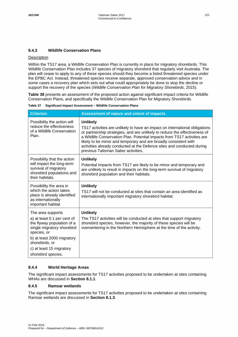
AECOM Talisman Saber 2017 Commercial-in-Confidence
21-Feb-2016 Prepared for – Department of Defence – ABN: 68706814312
122
Wildlife Conservation Plans 8.4.3
Description
Within the TS17 area, a Wildlife Conservation Plan is currently in place for migratory shorebirds. This Wildlife Conservation Plan includes 37 species of migratory shorebird that regularly visit Australia. The plan will cease to apply to any of these species should they become a listed threatened species under the EPBC Act. Instead, threatened species receive separate, approved conservation advice and in some cases a recovery plan which sets out what could appropriately be done to stop the decline or support the recovery of the species (Wildlife Conservation Plan for Migratory Shorebirds, 2015).
Table 38 presents an assessment of the proposed action against significant impact criteria for Wildlife Conservation Plans, and specifically the Wildlife Conservation Plan for Migratory Shorebirds.
Table 37 Significant Impact Assessment – Wildlife Conservation Plans
Criterion Assessment of nature and extent of impacts
Possibility the action will reduce the effectiveness of a Wildlife Conservation Plan.
Unlikely
TS17 activities are unlikely to have an impact on international obligations or partnership strategies, and are unlikely to reduce the effectiveness of a Wildlife Conservation Plan. Potential impacts from TS17 activities are likely to be minor and temporary and are broadly consistent with activities already conducted at the Defence sites and conducted during previous Talisman Saber activities.
Possibility that the action will impact the long-term survival of migratory shorebird populations and their habitats.
Unlikely
Potential impacts from TS17 are likely to be minor and temporary and are unlikely to result in impacts on the long-term survival of migratory shorebird population and their habitats.
Possibility the area in which the action takes place is already identified as internationally important habitat
Unlikely
TS17 will not be conducted at sites that contain an area identified as internationally important migratory shorebird habitat.
The area supports
a) at least 0.1 per cent of the flyway population of a single migratory shorebird species, or
b) at least 2000 migratory shorebirds, or
c) at least 15 migratory
shorebird species.
Unlikely
The TS17 activities will be conducted at sites that support migratory shorebird species, however, the majority of these species will be overwintering in the Northern Hemisphere at the time of the activity.
World Heritage Areas 8.4.4
The significant impact assessments for TS17 activities proposed to be undertaken at sites containing WHAs are discussed in Section 8.1.1.
Ramsar wetlands 8.4.5
The significant impact assessments for TS17 activities proposed to be undertaken at sites containing Ramsar wetlands are discussed in Section 8.1.3.

AECOM Talisman Saber 2017 Commercial-in-Confidence
21-Feb-2016 Prepared for – Department of Defence – ABN: 68706814312
123
Biosphere Reserves 8.4.6
Description
None of the sites proposed for use for TS17 contain biosphere reserves, with the nearest Biosphere Reserve being the Great Sandy Biosphere which is more than 300km away from SWBTA.
Nature and extent of likely impact
Not applicable.
Commonwealth Reserves (Marine or Terrestrial) 8.4.7
Description
There are no Commonwealth Reserves (marine or terrestrial) located within the TS17 area. The closest Reserve is the Kakadu National Park which is a terrestrial Commonwealth Reserve, bound to the east of the MBTA. Considering the nature of the activity and that the activities will not be conducted within a Commonwealth Reserve, it is considered unlikely that the action will damage any Commonwealth Reserves.
Nature and extent of likely impact
Not applicable.

AECOM Talisman Saber 2017 Commercial-in-Confidence
21-Feb-2016 Prepared for – Department of Defence – ABN: 68706814312
124
9.0 EPBC Act Permit Requirements The EPBC Act requires a permit under Part 13 for activities which may kill, injure, take, trade, keep or move a member of a listed threatened species or ecological community, a member of a listed migratory species, or a member of a listed marine species in or on a Commonwealth area.
TS17 will be undertaken on Commonwealth land and marine areas. While accidental impacts on individual members of species that may be protected under the EPBC Act are possible, such impacts are not predictable and have not occurred in the past due to the comprehensive suite of environmental mitigation measures applies at Defence sites. Existing reporting protocols would treat such impacts as incidents and these would be reported to the Department of Environment and Energy for investigation wherever appropriate. The significant impact assessment (see Section 8.0 for the summary and Appendix Z, Appendix AA, Appendix BB, Appendix CC and Appendix DD for details) determined that it is unlikely that TS17 will have a significant impact on individual critically endangered, endangered, migratory or marine species, and that it is unlikely that TS17 will have a significant impact on an important population of a vulnerable species or a threatened species as a whole.
As such, Defence does not seek permits under Section 525 of the EPBC Act and does not need to impose additional conditions on TS17 to ensure that permits can be attained.
The assessments against each of the threatened, marine or migratory species with a likelihood of occurrence of moderate or greater (see Appendix N for likelihood of significance determination), are provided in Appendix Z, Appendix AA, Appendix BB and Appendix DD. In addition, the details of recovery plans are provided in Appendix D and the mitigation measures that will be implemented to comply with legislative requirements, including recovery plans, and reduce the risks to protected species and ecological communities, are provided in Section 7.2.
AECOM Talisman Saber 2017 Commercial-in-Confidence
21-Feb-2016 Prepared for – Department of Defence – ABN: 68706814312
125
10.0 Conclusion Talisman Saber Exercises are designed to improve combat training, readiness and interoperability, providing invaluable experience to ADF personnel and enhancing the ADF’s capability to provide and contribute to regional security. TS17 will be the latest in a series of large scale military exercises that has taken place in Australia over several decades. The nature of the Exercise and its activities are well understood from previous experience, the environmental impacts have been comprehensively assessed in consultation with authorities such as GBRMPA, DoEE and DEHP Qld, and Defence has instituted robust measures and procedures to avoid and minimise impacts, to record incidents and respond to and repair any damage.
This PER has been specifically developed to:
Identify and assess TS17 activities and potential environmental impacts – this includes the potential for significant impact on MNES listed under the EPBC Act, as well as ‘the environment’ more broadly as defined in Section 528 of the EPBC Act;
Identify the environmental controls and mitigation measures to be implemented to avoid or minimise the risk of environmental impacts arising; and
Communicate this to the Australian public and stakeholders.
From experience gained in previous exercises and similar activities to TS17, the ADF, US Armed Forces, Canadian and NZ Armed Forces understand and are well prepared to provide the necessary resources, controls and tools required to avoid and / or mitigate environmental impacts. This will be the seventh Talisman Saber exercise conducted and there have been no significant environmental impacts since it first began. This experience is also gained from the routine and regular use of Defence’s training facilities, providing a pathway of continual improvement in environmental management for Defence training activities and the environmental management of the facilities more broadly. Defence enhances this understanding and experience through the provision and distribution of environmental awareness materials that describe environmental behaviours and procedures to be adopted by personnel on Defence and non-Defence land.
The demonstrated avoidance of any significant impacts during previous iterations of Talisman Saber exercises provides confidence that Defence’s evolved environmental planning and management systems are effective and can be relied upon to manage the environmental impacts of TS17.
It has been determined that, when the suite of environmental controls to be implemented for TS17 is taken into account, there is little real chance or possibility that the proposed TS17 activities will have significant impacts on protected MNES, or the environment on Commonwealth land, provided existing protocols and plans are implemented. It is also considered that there is little real chance or possibility that the action by the Commonwealth will have a significant impact on the environment.
While it is acknowledged that TS17 has the potential to generate environmental impacts such as weed dispersal and damage to native vegetation, impacts are expected to be short-term, recoverable and consistent with the ongoing use of Defence training areas and Gazetted Defence Practice Areas for similar activities. Defence is committed to ensuring that potential environmental impacts associated with TS17 have been adequately identified and considered, and are being managed responsibly. Defence will consider any feedback received during the exhibition period of the final PER as part of final planning for the Exercise.

AECOM Talisman Saber 2017 Commercial-in-Confidence
21-Feb-2016 Prepared for – Department of Defence – ABN: 68706814312
126
11.0 References ADF (2001) Standing Orders for Cowley Beach Training Area, Chapter 13 Environmental and Heritage Management, Australian Defence Force, December 2001.
AECOM (2016) Talisman Saber Amphibious landing in the Stanage Bay area, 19 October 2016 (draft).
AECOM (2015) Talisman Sabre 2015 Northern Territory Beach Landing Exercise, 30 April 2015 (draft).
AECOM (2011) Talisman Sabre 2011 – Public Environmental Report, April 2011.
AECOM (2010) Heritage and Environmental Management Plan: Mount Bundey Training Area. Unpublished Report Prepared by Department of Defence.
Aurecon (2012a) Talisman Saber Environmental Management Plan, November 2012.
Aurecon (2012b) Talisman Saber 2013 Final Public Environment Report, December 2012.
Bamford, M (2015) Talisman Sabre 2015 Northern Territory Beach Land Exercise Report on Fauna Observations December, Report for AECOM, 9 March 2015.
Buxton, C. D. and Cochrane, P. (2015). Commonwealth Marine Reserves Review: Report of the Bioregional Advisory Panel. Department of the Environment, Canberra.
Department of Defence (2008) State of the Environment Report for Shoalwater Bay Training Area 2008.
Department of Defence (2013) Exercise Talisman Saber 13 Environmental Post Exercise Report, 20 December 2013.
Department of Defence (not yet released) Australian Defence Force Publication (ADFP) 7.0.3 – Exercise Planning and Conduct (ed 3).
Department of the Environment (2013) Significant Impact Guidelines 1.1 – Matters of National Environmental Significance, Environment Protection and Biodiversity Conservation Act 1999, 2013.
Department of the Environment (2014). EPBC Act referral guidelines for the Outstanding Universal Value of the Great Barrier Reef World Heritage Area. Commonwealth of Australia, viewed on 19 November 2016, < http://www.environment.gov.au/system/files/resources/e8e47508-5ea4-457b-adef-b9c1364e9bec/files/referral-guidelines-great-barrier-reef_0.pdf>
Department of the Environment (2014) EPBC Protected Matters Search Tool, Accessed June 2014, Commonwealth Department of Sustainability, Environment, Water, Population and Communities.
Department of Environment and Energy (DoEE) 2016a, Species Profile and Threats Database, Commonwealth of Australia, viewed on 17 November 2016, <http://www.environment.gov.au/cgi-bin/sprat/public/sprat.pl>.
Department of Environment and Energy (DoEE) 2017, Species Profile and Threats Database – Register of Critical Habitat, Commonwealth of Australia, viewed on 27 January 2017, < http://www.environment.gov.au/cgi-bin/sprat/public/publicregisterofcriticalhabitat.pl>.
Department of Environment and Heritage Threatened Species Unit (Qld), Griffith University, James Cook University, Queensland Turtle Conservation Project (2012) Turtle and Dugong Research and Monitoring, Western Shoalwater Bay, 25 June - 5 July 2012, A. Marine turtles, unpublished report.
Department of Environment and Resource Management (2010) National recovery plan for the water mouse (false water rat) Xeromys myoides. Department of Environment and Resource Management, State of Queensland.
Department of Natural Resources, Environment and the Arts (2007) Darwin Parks Biodiversity Monitoring 2007 Baseline Report: Casuarina Coastal Reserve, Charles Darwin National Park, Holmes Jungle, Howard Springs Nature Reserve and Hunting Reserve, Department of Natural Resources, Environment and the Arts, Northern Territory Government, Darwin.

AECOM Talisman Saber 2017 Commercial-in-Confidence
21-Feb-2016 Prepared for – Department of Defence – ABN: 68706814312
127
Department of Sustainability, Environment, Water, Population and Communities (2012a) Marine bioregional plan for the North Marine Region, Canberra.
Department of Sustainability, Environment, Water, Population and Communities (2012b) Commonwealth marine environment report card: Supporting the marine bioregional plan for the North Marine Region, Canberra.
Department of Sustainability, Environment, Water, Populations and Communities (2012c) Advice to the Minister for Sustainability, Environment, Water, Population and Communities from the Threatened Species Scientific Committee (the Committee) on an Amendment to the List of Threatened Ecological Communities under the Environment Protection and Biodiversity Conservation Act 1999 (EPBC Act), DSEWPaC, May 2012.
Department of Sustainability, Environment, Water, Populations and Communities (2013) Significant impact guidelines: 1.2 – Actions on, or impacting upon, Commonwealth land and Actions by Commonwealth Agencies, June 2013.
GHD (2007) Shoalwater Bay Landscape Monitoring Program Report 2007 Implementation, Unpublished Report Prepared for the Department of Defence, September 2007.
Great Barrier Reef Marine Park Authority (2014) Great Barrier Reef Region Strategic Assessment: Strategic Assessment Report, viewed on 21 October 2016, http://elibrary.gbrmpa.gov.au/jspui/handle/11017/2861.
Great Barrier Reef Marine Park Authority (2014b) Great Barrier Reef Outlook Report 2014, viewed on 21 October 2016 < http://www.gbrmpa.gov.au/cdn/2014/GBRMPA-Outlook-Report-2014/>.
Great Barrier Reef Marine Park Authority (2015) Reef 2050 Long-Term Sustainability Plan, viewed on 21 October 2016 <http://www.environment.gov.au/marine/gbr/publications/reef-2050-long-term-sustainability-plan>.
Hewitt AD, Jenkins TF, Ranney TA, Stark JA, Walsh ME, Taylor S, Walsh MR, Lambert DJ, Perron NM, Collins NH and Karn R (2003) Estimates for Explosive Residue for the Detonation of Army Munitions US Army Corps Engineers, Engineer Research and Development Centre.
HLA (2004a) Cowley Beach Training Area Land Management Strategy Prepared for Corporate Services Infrastructure – NQ. Unpublished Report Prepared for Department of Defence, April 2004.
HLA (2004b) Environmental Impact Assessment of Defence Training Activities at Cowley Beach Training Area Unpublished Report Prepared for the Department of Defence.
Jaensch R (2008) A condition assessment of wetlands and waterbirds in the Shoalwater Bay Training Area Wetlands International, February 2008.
James Cook University, Department of Environment and Heritage, Threatened Species Unit (2012) ‘Turtle and Dugong Research and Monitoring, Western Shoalwater Bay, 25 June - 5 July 2012, B. Marine turtle satellite telemetry', unpublished report.
James Cook University, Department of Environment and Heritage Threatened Species Unit (2012) ‘Turtle and Dugong Research and Monitoring, Western Shoalwater Bay, 25 June - 5 July 2012, C. Dugong satellite telemetry’, unpublished report.
Northern Territory Government, Department of Natural Resources, Environment the Arts and Sport, Land and Water Division (2008) Acid Sulfate Soils of the Darwin Region Technical Report No.09/2008D), November 2008.
PGM Environment and Eco Logical Australia 2014. Strategic Environmental Assessment of Defence Activities in the Great Barrier Reef World Heritage Area, 2014. Prepared for Department of Defence.
Taylor, B.L., Baird, R., Barlow, J., Dawson, S.M., Ford, J., Mead, J.G., Notarbartolo di Sciara, G., Wade, P. & Pitman, R.L. 2008. The IUCN red list of threatened species. http://www.iucnredlist.org. Accessed December 2016.
The Minke Whale Project (n.d.) Welcome to the Minke Whale Project, viewed on 13 December 2016 < http://www.minkewhaleproject.org/>

AECOM Talisman Saber 2017 Commercial-in-Confidence
21-Feb-2016 Prepared for – Department of Defence – ABN: 68706814312
128
Umwelt (2017) Stage 2A Interim Assessment Report: Landing Helicopter Dock Landing Craft – Volume 1 Main Text and Appendices, January 2017.
United Nations Educational, Scientific and Cultural Organisation (2017) Great Barrier Reef, viewed on 17 November 2016 < http://whc.unesco.org/en/list/154>
United Nations Educational, Scientific and Cultural Organisation (2017) Kakadu National Park, viewed on 17 November 2016 < http://whc.unesco.org/en/list/147>
United Nations Educational, Scientific and Cultural Organisation (2017) Wet Tropics of Queensland, viewed on 17 November 2016 < http://whc.unesco.org/en/list/486>