talbot village - bournemouth · pdf file1 1. introduction 1.1 the talbot village conservation...
TRANSCRIPT
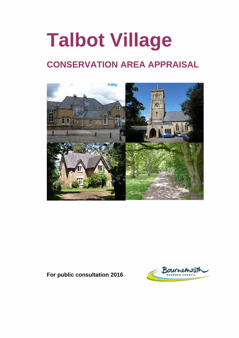
Talbot Village
CONSERVATION AREA APPRAISAL
For public consultation 2016

Produced by: Bournemouth Borough Council Design & Heritage Planning Services All maps within this document are reproduced from Ordnance Survey material with the permission of Ordnance Survey on behalf of the Controller of Her Majesty’s Stationery Office. © Crown copyright. Bournemouth Borough Council 100019829. 2015/2016
The aerial photograph is copyright © BLOM Pictometry 2009
Join in This document, and the accompanying draft Management Plan, have been prepared for public consultation and we would like to hear your views on the content of both. We invite you to write to us. Response forms are available from:
1. www.bournemouth.gov.uk/talbotvillageconservationarea
2. Winton and Ensbury Park Libraries
3. Town Hall Customer Services Centre, St Stephen’s Road BH2 6EB
Please send your completed response forms/comments: By email to: [email protected] Or By post to Design and Heritage Team
Town Hall Annexe St Stephen’s Road Bournemouth BH2 6EA
Copies of the full documents and summaries are available from the web address and locations above.
The closing date for responses is 29th
February 2016

2
Contents: 1. Introduction 2. The Planning Policy Context
Primary Legislation National Policy and guidance Bournemouth Local Plan
3. Summary of Special Interest 4. Location and Setting 5. Historical Development 6. Spatial Analysis
Relationship of Spaces Key Views and Vistas Landmarks
7. Character Analysis
Plan Form Activity and Uses Definition of character areas Architectural and historic qualities Trees, planting and green spaces The public realm General condition of buildings
8. Contribution of Buildings
Listed buildings Positive buildings Neutral buildings Negative buildings
9. Boundary review 10. Management: Issues and Challenges
Strategic issues
Organisational issues
Policy & control
Economic issues
Spatial Issues
Site specific issues
11. Community Involvement
3
Appendices: 1. Properties within the Conservation Area 2. Current Planning Policy Wording
List of Figures: 1. Conservation Areas in Bournemouth 2. Boundary of Talbot Village Conservation Area 3. Local Plan policy designations 4. Design No.2 – P F Robinson 5. Aerial View of the Conservation Area 6. Ordnance Survey of 1810
7. Talbot Village Estate Map around 1870
8. Talbot Village Estate Map around 1903
9. Character areas
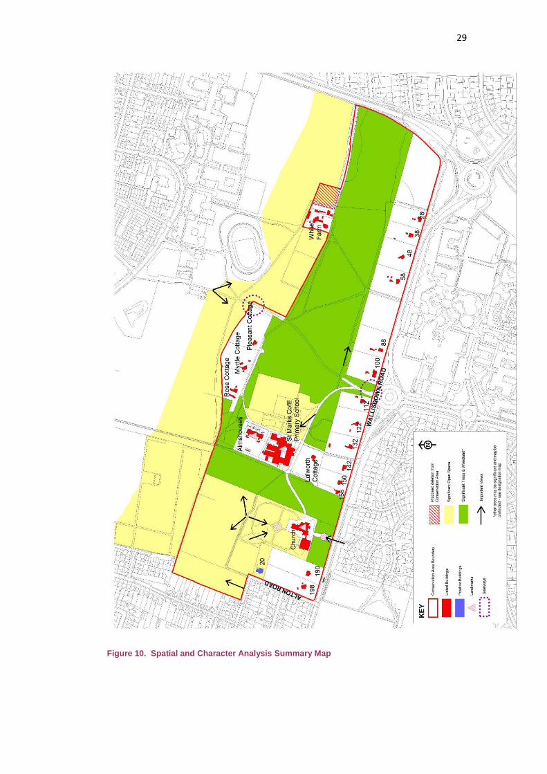
10. Spatial and Character Analysis Summary Map
1
1. Introduction
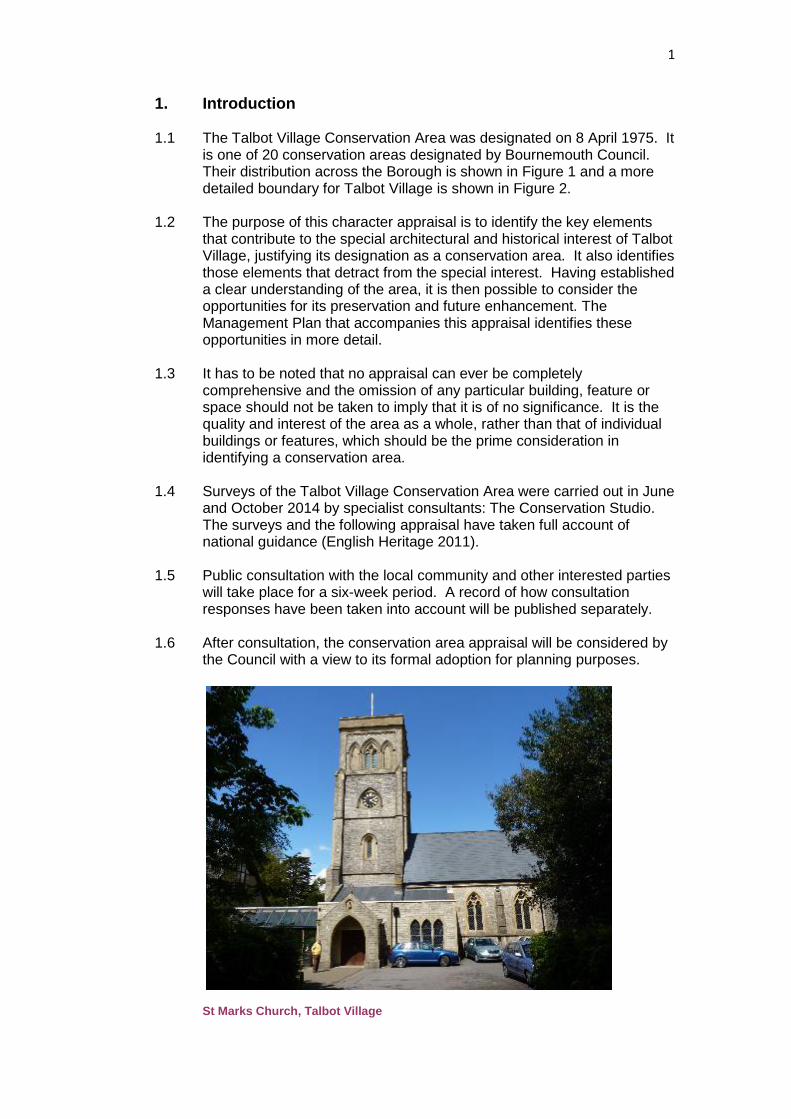
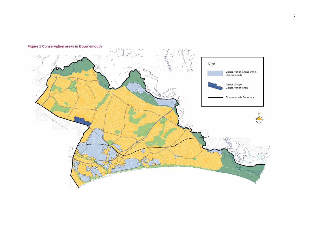
1.1 The Talbot Village Conservation Area was designated on 8 April 1975. It
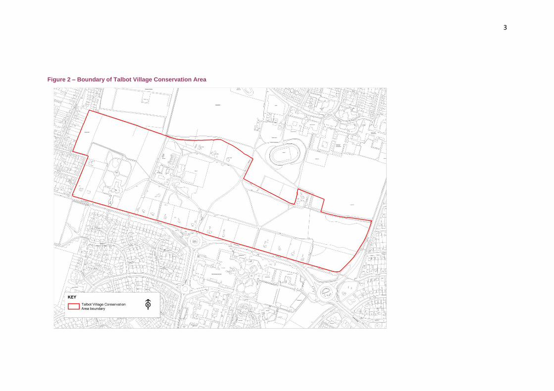
is one of 20 conservation areas designated by Bournemouth Council. Their distribution across the Borough is shown in Figure 1 and a more detailed boundary for Talbot Village is shown in Figure 2.
1.2 The purpose of this character appraisal is to identify the key elements
that contribute to the special architectural and historical interest of Talbot Village, justifying its designation as a conservation area. It also identifies those elements that detract from the special interest. Having established a clear understanding of the area, it is then possible to consider the opportunities for its preservation and future enhancement. The Management Plan that accompanies this appraisal identifies these opportunities in more detail.
1.3 It has to be noted that no appraisal can ever be completely
comprehensive and the omission of any particular building, feature or space should not be taken to imply that it is of no significance. It is the quality and interest of the area as a whole, rather than that of individual buildings or features, which should be the prime consideration in identifying a conservation area.
1.4 Surveys of the Talbot Village Conservation Area were carried out in June
and October 2014 by specialist consultants: The Conservation Studio. The surveys and the following appraisal have taken full account of national guidance (English Heritage 2011).
1.5 Public consultation with the local community and other interested parties
will take place for a six-week period. A record of how consultation responses have been taken into account will be published separately.
1.6 After consultation, the conservation area appraisal will be considered by
the Council with a view to its formal adoption for planning purposes. St Marks Church, Talbot Village
2
Figure 1 Conservation areas in Bournemouth
3
Figure 2 – Boundary of Talbot Village Conservation Area
4
2. The Planning Policy Context
Primary Legislation 2.1 The concept of Conservation Areas was introduced by the Civic
Amenities Act 1967, in recognition of the need to look beyond the listing of individual buildings, and to protect the relationships between significant buildings and spaces.
2.2 Current Government legislation is set out in the Planning (Listed
Buildings and Conservation Areas) Act 1990, which defines conservation areas as ‘areas of special architectural or historic interest the character or appearance of which it is desirable to preserve or enhance.’ The Act places statutory duties on local planning authorities:
To identify and designate such areas and to review them from time to
time (Section 69) To pay special attention to preserving or enhancing the character of
conservation areas when exercising planning powers, for instance when considering planning proposals (Section 72)
To publish proposals for the preservation and enhancement of conservation areas (section 71)
Conservation area appraisals can be the means for meeting some of these requirements.
2.3 The principal consequences of designation are controls over the
demolition of buildings and over works to trees. Planning permission is required for the demolition of most unlisted buildings, and the extent to which they make a contribution to the character of the area will be a factor in decision-making. This is less relevant in Talbot Village where most of the buildings are statutorily listed, so listed building consent is already required for works of demolition, alteration or extension.
2.4 Where it is proposed to lop, top or fell any tree within a conservation
area, above the minimum size of 75mmdiameter measured at 1.5m above ground level, six weeks’ notice must be served on the Council. In this time they will either agree that works can go ahead or they may serve a Tree Preservation Order.
National Policy and guidance
2.5 The National Planning Policy Framework (NPPF) sets out Government planning policies and how they are expected to be applied. It notes that the purpose of the planning system is to contribute to the achievement of sustainable development, expressed as: economic, social and environmental roles. The environmental role includes, ‘contributing to protecting and enhancing our natural, built and historic environment...’ (para.7).
2.6 Conserving heritage assets is one of the 12 core land-use planning
principles that the NPPF sees as underpinning both plan-making and decision-taking (para.17).
2.7 The NPPF defines ‘heritage assets’ as a range of buildings, monuments,
sites and places that have ‘a degree of significance meriting consideration in planning decisions because of their heritage interest’.
5
This definition includes ‘designated heritage assets’ where they are specifically protected – for instance as ancient monuments, listed buildings or conservation areas – or where they are registered by English Heritage - historic parks and gardens of special historic interest.
2.8 The NPPF defines ‘significance’ as: ‘The value of a heritage asset to this
and future generations because of its heritage interest. That interest may be archaeological, architectural, artistic or historic.’ It adds that, ‘Significance derives not only from a heritage asset’s physical presence, but also from its setting.’
2.9 Not all elements of a conservation area will necessarily contribute to its
significance (para.138) and when considering the designation of conservation areas, local planning authorities should ensure that an area justifies such status because of its special architectural or historic interest (para.127).
2.10 The NPPF must be taken into account in the preparation of local and
neighbourhood plans, and it is a material consideration in planning decisions. Any harm to the significance of heritage assets that would be caused by development proposals will require clear and convincing justification and weighed against the public benefits of the proposal.
2.11 Advice on the interpretation and implementation of the NPPF is provided
in the National Planning Practice Guidance (NPPG), which has chapters on, for instance, ‘Conserving and Enhancing the Historic Environment’ and on ‘Design’. This is an on-line resource, accessed through the Government’s Planning Portal, and is subject to periodic updates.
2.12 In addition, extensive guidance is provided by English Heritage through
its HELM (Historic Environment: Local Management) initiative.
Bournemouth Local Plan 2.13 The Local Plan for Bournemouth consists of several documents. The
primary document is the Core Strategy which provides the spatial strategy for the Borough for the period 2006 to 2026. It was adopted in October 2012.
2.14 The Core Strategy is supplemented by further documents that may be
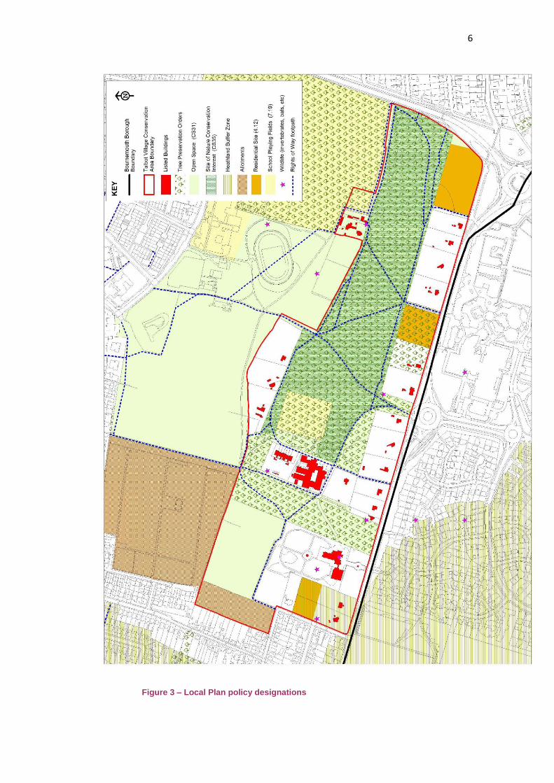
geographically specific, such as the Town Centre Area Action Plan, or cover a particular topic, such as Affordable Housing. In addition, some of the policies from the previous Bournemouth District Wide Local Plan 2002 are ‘saved’ and are therefore still relevant. They will be superseded in time by policies in new development plan documents (DPD), such as the forthcoming Development Management Policies. The full wording of Local Plan policies relevant to this appraisal is provided at Appendix 2. For a full schedule of all current planning policies, see the Council’s web site. The most relevant planning policies that apply to the Talbot Village Conservation Area are shown in Figure 3.
6
Figure 3 – Local Plan policy designations

7
Core Strategy (2012) 2.15 The Core Strategy acknowledges
the NPPF requirement to have a proactive strategy for the conservation and enjoyment of the historic environment. It confirms that the Council is producing a set of conservation area appraisals that provide information on each conservation area with advice to owners, occupiers and prospective developers on how they should be maintained.
2.16 The Core Strategy states that
opportunities for continuing to understand, preserve and enhance Bournemouth’s historic assets will be sought through a range of initiatives including conservation area appraisals. Policy CS39 seeks to protect designated assets, which include conservation areas (see appendix 2).
2.17 Other relevant Core Strategy policies include Policy CS1, CS12, CS31,
CS33, CS35 and CS41. Policy CS1 states that in making planning decisions the Council will reflect the presumption in favour of sustainable development and will encourage use of the pre-application process to find appropriate solutions. Policy CS12 safeguards allotments, while CS31 protects public and private open spaces from development. Policy CS33 protects heathland. Policy CS35 addresses Sites of Nature Conservation Interest. Policy CS41 promotes a high quality of design in all developments.
District Wide Local Plan (2002)
2.18 Policy 4.4 of the Bournemouth District Wide Local Plan 2002 is still relevant to planning decisions affecting conservation areas. The policy expects development proposals to preserve or enhance the character of conservation areas by having regard to design issues such as scale, density, height, form, massing and layout as well as protecting existing elements, such as street pattern, spaces, trees and views.
2.19 Policy 4.12 is specific to the Talbot Village Conservation Area. It
restricts further development to no more than six dwellings on specific sites and improvements to the school. It also resists the introduction of urban detailing, such as kerbs to the roads and lighting.
2.20 Another relevant planning policy in the District Wide Local Plan is Policy
7.19, which seeks to safeguard school playing fields. 2.21 These saved policies will remain as material considerations in the
determination of planning applications until they are superseded by polices in the forthcoming Development Management Policies DPD.
8
Talbot Village Conservation Area 2.22 In 1995 the Council published a leaflet about the conservation area and
the effects of designation. This leaflet will be superseded by this Conservation Area Appraisal once it is adopted.
3. Summary of Special Interest
A visionary model village developed by the sisters, Georgina and Marianne Talbot in the 1850s inspired by the writings of philanthropist Robert Owen who developed New Lanark in Scotland in the early 18th century (now a World Heritage site)
The village survives intact reflecting the integrity of its original model concept
Talbot Village was built about the same time as more-famous model villages, such as the Saltaire World Heritage Site in West Yorkshire
Unlike settlements developed to improve industrial workforces, Talbot Village was a purely philanthropic endeavour to address local poverty
Cottages were laid out on large plots to encourage self-sufficiency They were designed in a rustic and picturesque style with
exaggerated historical features Designs were derived from Victorian pattern books by writers such
as J C Loudon and P F Robinson The school and a row of almshouses designed by Christopher
Crabbe Creeke, the Surveyor of Bournemouth The village was completed in 1870 by the construction of St Marks
Church designed by Evans and Fletcher, architects from Wimborne The higher status of the church and almshouses is emphasised by
the use of stone White Farm is the only farm house and outbuildings remaining within
a rural setting of the six farms that once served the Estate The cottages are characterised by a consistent use of brickwork with
tiled or slated roofs and leaded light windows The buildings are largely enclosed by mature woodland consisting of
both specimen and self-seeded trees The woodland generates a tranquil atmosphere within the
conservation area contrasting with the business of the adjacent Wallisdown Road
The informal nature of the roads and paths adds to the rural character of the area
Almost all the buildings are statutorily listed. This emphasises the high significance of Talbot Village and the importance of the setting of the buildings in the Conservation Area
Ownership remains with the Talbot Village Trust that was set up by the Talbot sisters
9
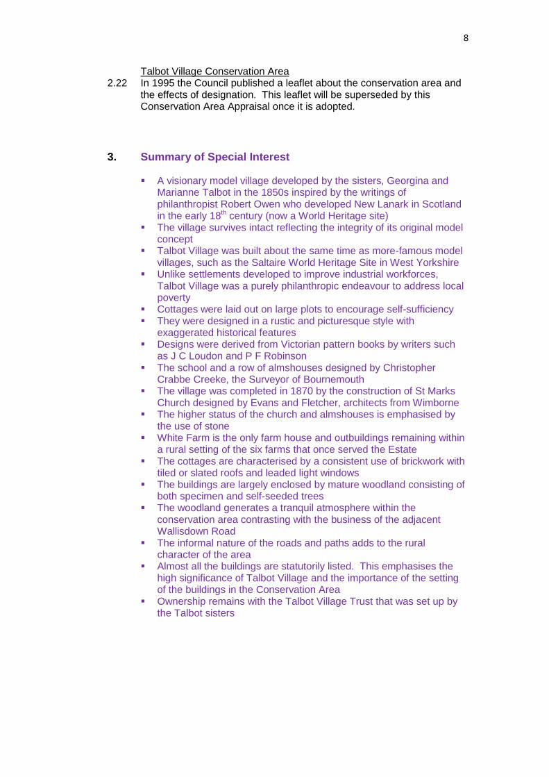
Figure 4. A cottage in the old English style – Design No.2 – P F Robinson 1837
4. Location and Setting
4.1 The Talbot Village Conservation Area lies about 2.5km north west of
Bournemouth Town Centre on what is geologically the coastal gravel
terrace. The topography is incised by the river valleys of the Bourne to
the southwest, and the Stour to the north, so that the village is on a ridge
about 45m above sea level.
4.2 In the mid-19th century, Talbot Village was isolated in a setting of open
heathland, known as Wallis Down and later Talbot Heath. This setting
was gradually urbanised as Bournemouth and Poole developed and
expanded.
4.3 The south side of the conservation area is defined by Wallisdown Road
(A3049), which is also the Borough boundary. To the south, in the
Borough of Poole, are the modern campuses of Bournemouth University
and the Arts University Bournemouth, and an area of 1980s housing also
called Talbot Village. These developments have all been built on Talbot
Heath. The heathland that remains is protected by European law.
4.4 On the north side of the conservation area there is an area of open
space, formerly farmland, which is now used for recreation, school
buildings and allotment gardens. To the west, an area of housing,
known as Highmoor, was laid out in the late 19th century and further to
the north and east are the 20th century suburbs of Bournemouth.
4.5 In marked contrast with the neighbouring housing developments, the
historical Talbot Village is a very low-density settlement with its own
church and school. It is dominated by mature woodland that largely
obscures its built form.
10
4.6 Properties within the Talbot Village Conservation Area can be found at
Appendix 1.
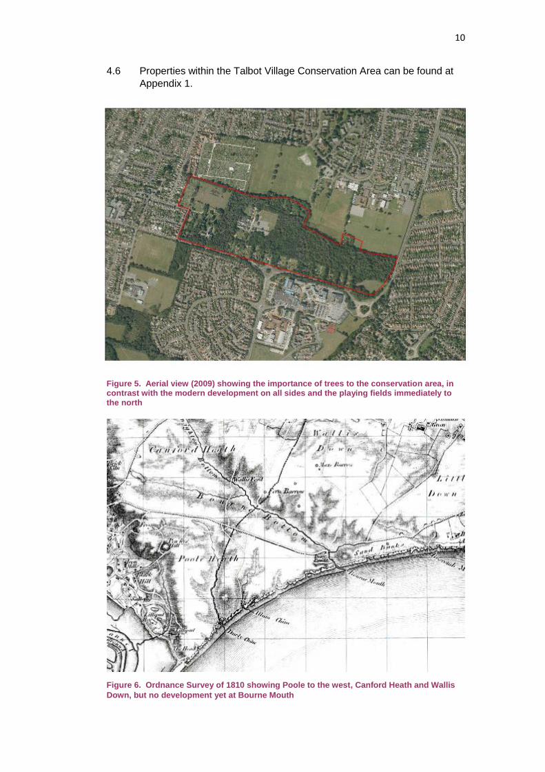
Figure 5. Aerial view (2009) showing the importance of trees to the conservation area, in contrast with the modern development on all sides and the playing fields immediately to the north
Figure 6. Ordnance Survey of 1810 showing Poole to the west, Canford Heath and Wallis
Down, but no development yet at Bourne Mouth
11
5. Historical Development
5.1 Archaeological finds have suggested that there was some Iron Age and
Romano-British activity in the general area. However, until the 19th century, the only significant settlement was the maritime town of Poole, which was first laid out in 1180. The large swathe of land from Christchurch to Dorchester was no more than low-grade heathland interspersed with occasional farmsteads.
5.2 This landscape began to change with the Enclosure Acts for
Christchurch (1802) and Great Canford (1822). As the land was not readily suited to agriculture, some of the new owners started plantations particularly of the Scots pines that have become so characteristic of the area. The effect of enclosure was that poor people could no longer make a living on what had previously been common land.
5.3 Much of the land that later became Talbot Village was acquired by the
Lord of the Manor of Christchurch, Sir George Ivison Tapps, and it later passed to a successor, Sir George Tapps-Gervis.
5.4 The seaside resort began when Lewis Tregonwell built a house in 1810
near the mouth of the Bourne - hence Bournemouth (see Figure 6 above). This still survives, much altered, at the core of the Royal Exeter Hotel. However, development did not gather pace until Sir George Tapps-Gervis laid out the Westover Estate in 1836 to designs by Benjamin Ferrey. In 1856, Christopher Crabbe Creeke was appointed as Surveyor to the Town Commissioners for Bournemouth. Creeke designed many hotels, villas and some public buildings that came to define the emerging character of the town.
5.5 The Talbot family descended from the Earls of Shrewsbury. Sir George
Talbot (1763-1850) inherited the Baronetcy of Mickleham near Dorking in Surrey. In addition to this country seat, he had a townhouse in Grosvenor Square and he owned the Portobello Estate in north Kensington.
5.6 Sir George had two daughters, Marianne and Georgina, who would
escape the rigours of London by visiting the Bournemouth area. In the 1840s they settled permanently at Hinton Wood House on the East Cliff. Georgina, in particular, was much moved by the poverty that had resulted from the enclosures. She was also aware of the writing of philanthropists such as Robert Owen, the developer of New Lanark, and of other model settlements built by land owners and industrialists.
5.7 Georgina began by renting land and providing employment for
impoverished people to carry out a programme of clearance and land improvements. She employed David Tuck, a local farmer and builder, to oversee the work.
5.8 In 1850, with the death of their father, the sisters inherited considerable
wealth. This was increased by the sale of the Portobello Estate for housing developments to meet the growing needs of London. The money enabled them to further their philanthropic ideals and they set about acquiring several parcels of land that eventually amounted to
12
some 465 acres in the Parish of Kinson just across the then county border in Dorset.
5.9 An area of 150 acres was retained as common land to provide animal
grazing for new tenants while six farms were laid out in varying sizes from Middle Farm (15 acres) to Talbot Village Farm (111 acres). White Farm (formerly Wareham’s Farm), the only farm house and outbuildings remaining within a rural setting – the land surrounding the farmhouse is no longer associated with it.
5.10 At the heart of the new holding, about 70 acres was reserved for the
model village. In all, 19 houses were built over about ten years from 1850. They had generous plots of about an acre, each with a well and outbuildings. Tenants were expected to develop sustainable lifestyles by keeping animals, such as pigs and chickens, and by growing their own fruit and vegetables
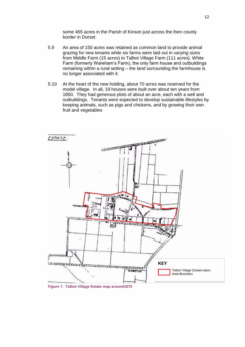
Figure 7. Talbot Village Estate map around1870
13
5.11 The sisters expected their charity to be met with a moral code to be
observed by all the tenants. The code banned alcohol and the carrying out of any trade, and it promoted neatness, good repair and healthy recreation.
5.12 The cottages were well-built in a picturesque style that was influenced by
John Nash’s designs for Blaize Hamlet. This ‘Old English style’ was made popular in Victorian pattern books by writers such as PF Robinson (See Figure 3) and John Claudius Loudon, whose ‘Encyclopaedia of cottages, farm and villa architecture and furniture’ had been published in 1833.
5.13 Most of the cottages lined the north side of Wallisdown Road opposite the common. Towards the west end of the village a school was built in 1862 to the Romanesque design of Christopher Creeke, the Surveyor of Bournemouth. It included a schoolmaster’s house and a small chapel that was endowed for the Vicar of Kinson to hold a service every Sunday. The school, with an original capacity for 66 pupils, had almost doubled by the end of the century. It was extended again in 1992 to accommodate 480 pupils.
Talbot Village School Almshouses
5.14 Also in 1862, and again to designs by Creeke, a row of almshouses with
seven sets of rooms was built to the north of the school. Each almshouse had an outhouse and a pig-sty.
5.15 The model village was completed in 1870 by the construction of St
Marks Church designed by Evans and Fletcher, architects from Wimborne, and the endowment for holding services was transferred from the school chapel. It is said that the Talbot sisters were distrustful of the morality of bell-ringers, so they had a mechanical carillon of twelve bells installed in the four-stage tower.
5.16 By the mid-20th century, the church had become the centre of its own
parish and in 1986 a large extension was built on its north side. This resulted in a liturgical re-orientation of the church on a north-south axis leaving the old chancel as a side chapel. In 1992, a substantial parish hall was added to the west of the church.
14
5.17 Georgina died in 1870, around the time that the church was completed, and the dedication of the church was brought forward so that she could be buried there. She is commemorated with an imposing stone cross in the churchyard. Her sister Marianne continued the charitable work established with the model village, including the planting of trees, until her death some 20 years later.
5.18 The Talbot sisters provided for
the longer-term future of the village by vesting it in a charitable trust. The Talbot Village Trust still owns all the land and buildings of the village with the exception of St Mark’s Church, the Vicarage and White Farm. It also still owns or has an interest in land outside the conservation area. The Talbot Village Trust has housing tenants within the Conservation Area, but has also funded sheltered accommodation, for elderly and disabled people, and housing for students in the wider area of South East Dorset. The Trust donates £800,000 to £1 million a year to local causes that meet with its charitable objectives.
5.19 Over time, Talbot Village has lost its rural isolation as the suburbs of
Bournemouth and Poole have expanded, and farming activity has become less relevant. In 1925, the first sale of land from the estate saw 27 acres in the south west go for commercial claypits. Then from the 1950s to the 1980s several parcels of land were released for educational purposes and for housing, some under compulsory purchase orders. The housing also known as Talbot Village, on the site of Talbot Village Farm was developed in the 1980s.
5.20 The historical boundary between Hampshire and Dorset followed the
north-south line of Boundary Road immediately to the east of the conservation area. With local government re-organisation in 1974, the boundary moved further east as Bournemouth and Christchurch were taken into Dorset. Since then Bournemouth has become an independent unitary authority.
15
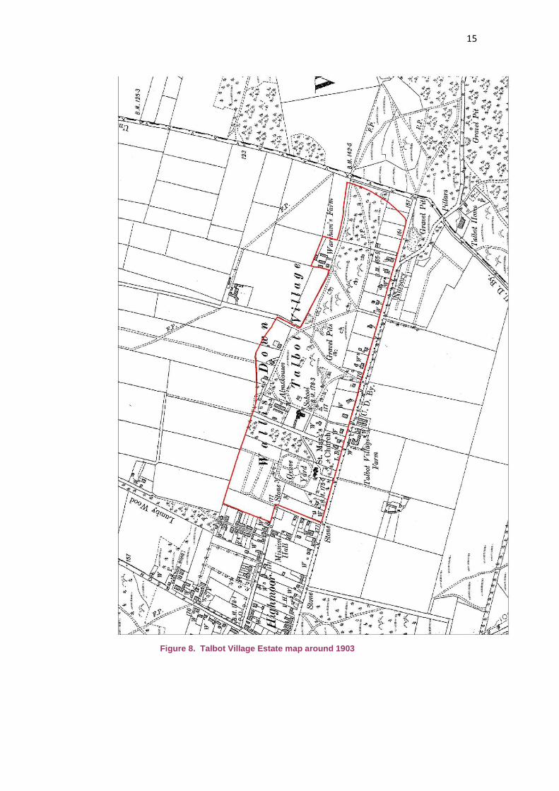
Figure 8. Talbot Village Estate map around 1903
16
6. Spatial Analysis Relationship of Spaces
6.1 The conservation area is characterised by a low density of buildings, which provide a marked contrast with the later housing and educational developments that now form its context. The buildings have a thickly wooded setting, although this was not always the case – key planting by the Talbot sisters and natural regeneration processes over time have created the treed character that we see today.
6.2 The area is unusual in that it is a model village and its layout was
conceived and built in a short period by a single owner. It is not, therefore, an evolved settlement like most historic villages where successive phases of development can be discerned.
6.3 The original plan is still very clear: individual cottages on plots of about
an acre were laid out along the north side of Wallisdown Road with the, then, common/heathland opposite. There is an area of open land to the south east where four plots were never developed. However, early maps show that there was once a building on the, now vacant, plot between Nos.58 and 88. To the rear of these buildings, a focus is provided by the school and the terrace of almshouses, close to which there are another four cottages on large plots along the northern boundary of the area. The result is a very contained and inward-looking settlement that is largely unseen by those passing by on Wallisdown Road.
6.4 The wider area was punctuated by a series of farms, of which White
Farm alone remains in the conservation area (The farmhouses of Lollipop Farm and Heath Farm survive outside the area within later developments). To the east of the school, and behind the frontage cottages, there is an extensive area of woodland initially planted by Marianne Talbot after Georgina’s death, but subsequently characterised by natural regeneration (Albion Woods). In 1889, the Ordnance Survey still shows this area largely as gravel pits.
6.5 To the west of the school is a further plantation and then the open burial
grounds associated with St Mark’s Church. To the north of this is an open paddock with an area of allotment gardens to the west.
6.6 The house plots now have more of an emphasis on use as ornamental
or recreational gardens than for subsistence farming and they tend to be surrounded by high mature hedges and trees. There is an open space in front of the school and almshouses that is used for car parking and play areas. Roads and paths are unadopted and informal, particularly where they criss-cross the dense woodland.
6.7 The churchyard is also flanked by trees but has a more open character.
The narrow entrance opens out into car parking around the church with the graveyards beyond and the paddock further still to the north.
17
View along rear access lane
Key Views and Vistas
6.8 Outside the conservation area, views along Wallisdown Road show the contrast between the trees and hedges fronting the cottages on the north side and the modern educational land-uses to the south. From the north, views across the playing fields are met by the impressive wooded edge of the conservation area. To the east, along Boundary Road, the tree canopy maintains a strong green border to the Conservation Area.
6.9 Internally, there are views across the open spaces towards the school,
the almshouses and the church. There are also unfolding views along the lanes, notably the straight rear access to the Wallisdown Road cottages, and there are glimpses through gateways to the cottages themselves.
6.10 Views out of the conservation area, across the paddock and allotments
to the north of the churchyard, are limited by tree cover which has the effect of screening out modern development so that a rural atmosphere is retained. This is unusual in an urban context.
View across the paddock Memorial to Georgina Talbot
18
Landmarks
6.11 While the cottages are largely hidden behind their hedges, the school, the almshouses and the church provide natural focal points viewed across open spaces. In addition, the memorial crosses to the two sisters are landmarks within the churchyard.
7. Character Analysis Plan form
7.1 Talbot Village was laid out on open heathland when the main features were the roads that defined the awards made under the Enclosure Acts. Wallisdown Road was one such road, while Boundary Road followed the, then, county boundary between Dorset and Hampshire.
7.2 This explains why most of the cottages follow a linear pattern along
Wallisdown Road rather than forming a nucleus. This also meant that the cottages faced onto the retained common grazing land on the south side of the road. The farms, however, were necessarily dispersed across the remainder of the estate.
7.3 Land to the rear of the line of cottages was used as gravel pits until part
of it was developed with the school and the almshouses. Then the church and its burial ground were added to the west. This layout with interconnecting lanes and paths has changed very little since 1870. Activity and Uses
7.4 Wallisdown Road is now a busy radial route serving both the town centre and the two universities. It is understandable, therefore, that the cottages on the north side tend to be protected by tall hedges. In complete contrast, however, the hinterland behind the cottage plots is peaceful with a distinct rural and woodland character even though it contains the school. The paddock to the north of the churchyard, used for horses, adds to this rustic character despite the nearby presence of 20th century housing developments.
19
View looking west along Wallisdown Road
7.5 The school and the church both generate traffic at the beginning and end
of the day. Events at the church hall lead to pressure for car parking, particularly along the road through the Plantation between St Mark’s Church and the school.
Definition of character areas
7.6 While the conservation area is not large, it does have nine distinct parts, which are shown on the plan at Figure 9:
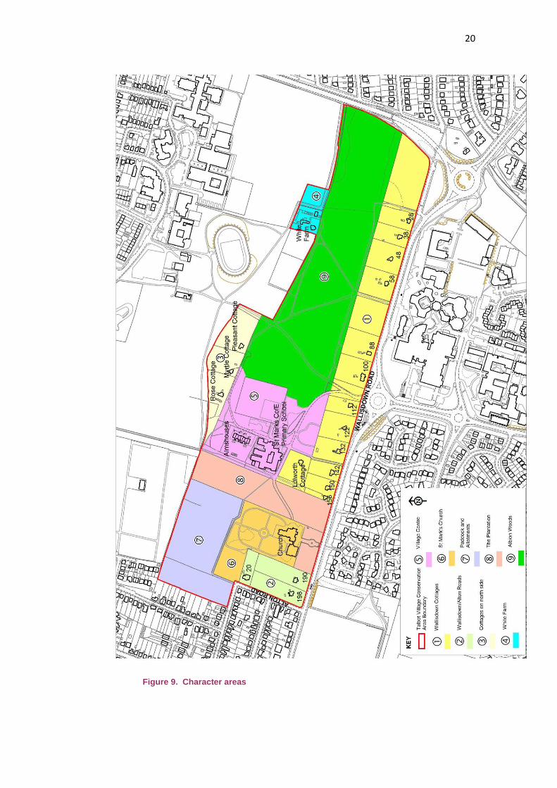
20
Figure 9. Character areas
21
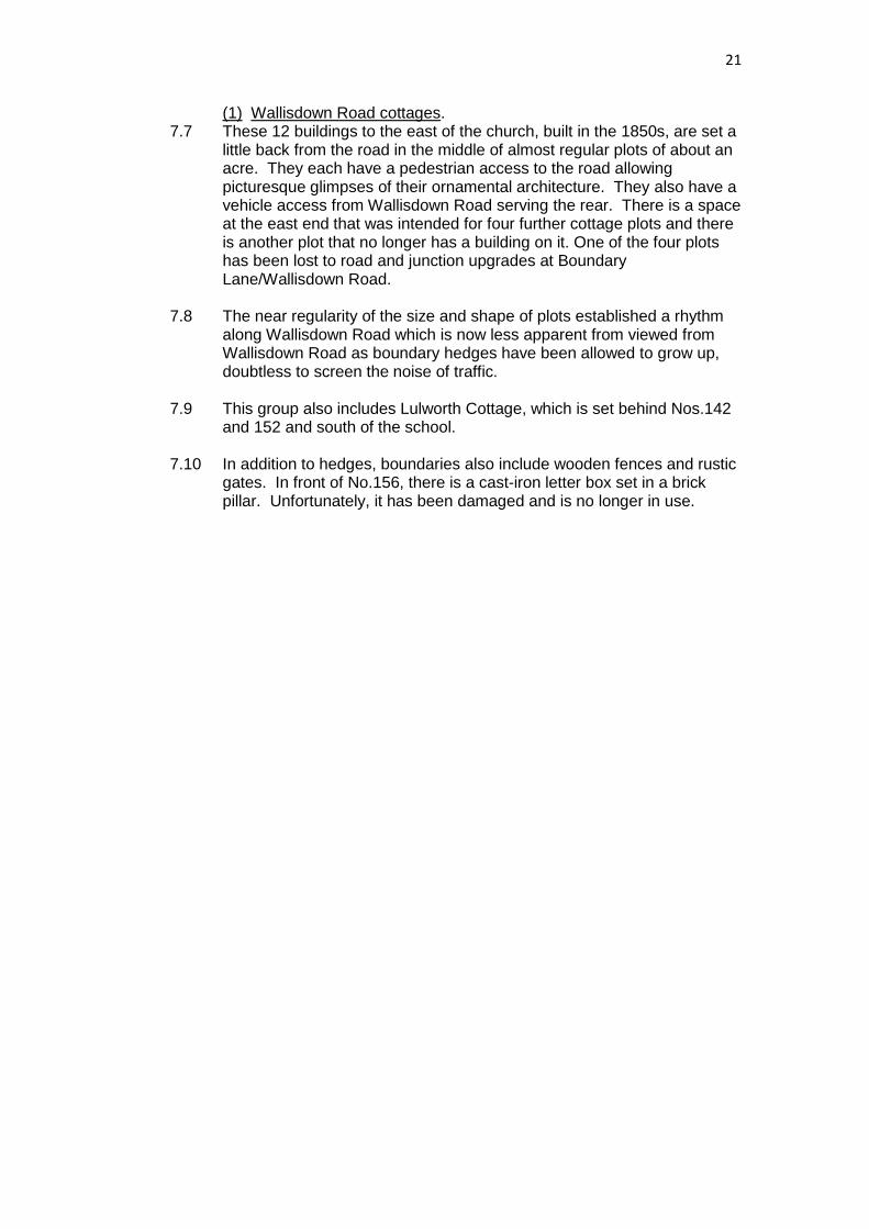
(1) Wallisdown Road cottages. 7.7 These 12 buildings to the east of the church, built in the 1850s, are set a
little back from the road in the middle of almost regular plots of about an acre. They each have a pedestrian access to the road allowing picturesque glimpses of their ornamental architecture. They also have a vehicle access from Wallisdown Road serving the rear. There is a space at the east end that was intended for four further cottage plots and there is another plot that no longer has a building on it. One of the four plots has been lost to road and junction upgrades at Boundary Lane/Wallisdown Road.
7.8 The near regularity of the size and shape of plots established a rhythm along Wallisdown Road which is now less apparent from viewed from Wallisdown Road as boundary hedges have been allowed to grow up, doubtless to screen the noise of traffic.
7.9 This group also includes Lulworth Cottage, which is set behind Nos.142 and 152 and south of the school.
7.10 In addition to hedges, boundaries also include wooden fences and rustic
gates. In front of No.156, there is a cast-iron letter box set in a brick pillar. Unfortunately, it has been damaged and is no longer in use.
22
(2) Wallisdown/Alton Roads. 7.11 The two cottages at the west end of the conservation area were built
after the church in about 1870. They are set further back with much deeper plots and a more wooded character than the main group.
7.12 Behind them is the Vicarage that was added in 1934. Although essentially plain, it does have generous eaves, a brick storey band and a full-height porch with an arched upper window. The D-shaped drive has distinctive brick piers to the entrances.
7.13 At the junction of the two roads there is a marker stone inscribed ‘Talbot Village’. (3) Cottages on the north side.
7.14 While the other cottages line the pre-existing enclosure road, Rose Cottage, Myrtle Cottage and Pleasant Cottage were built later in the 1850s on the north side of the conservation area looking in towards the centre.
7.15 They too are set in the generous plots intended by the Talbot sisters to promote self-sufficiency. Indeed, Pleasant Cottage is on an even more generous plot than it neighbours, relating to the original layout of the field boundaries to the north.
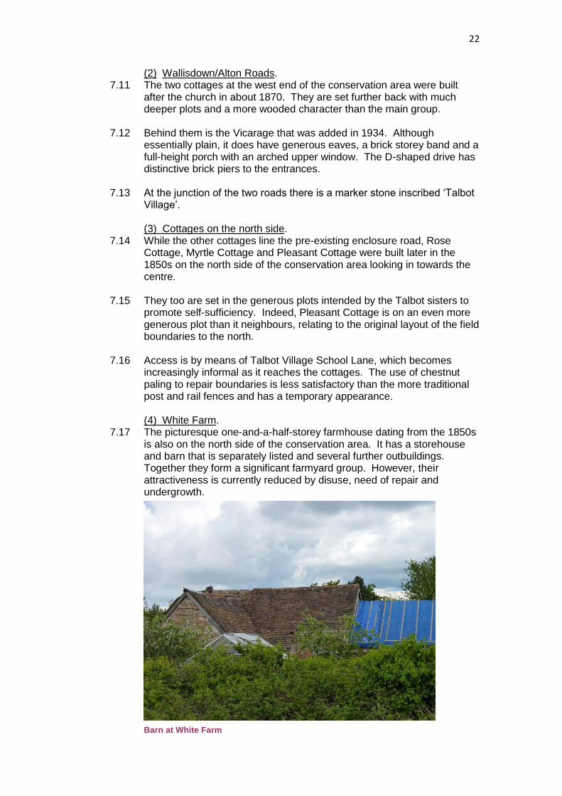
7.16 Access is by means of Talbot Village School Lane, which becomes increasingly informal as it reaches the cottages. The use of chestnut paling to repair boundaries is less satisfactory than the more traditional post and rail fences and has a temporary appearance. (4) White Farm.
7.17 The picturesque one-and-a-half-storey farmhouse dating from the 1850s is also on the north side of the conservation area. It has a storehouse and barn that is separately listed and several further outbuildings. Together they form a significant farmyard group. However, their attractiveness is currently reduced by disuse, need of repair and undergrowth. Barn at White Farm
23
7.18 The farmland once associated with White Farm is now recreation grounds outside the conservation area but providing an appropriately open setting. (5) The Village centre.
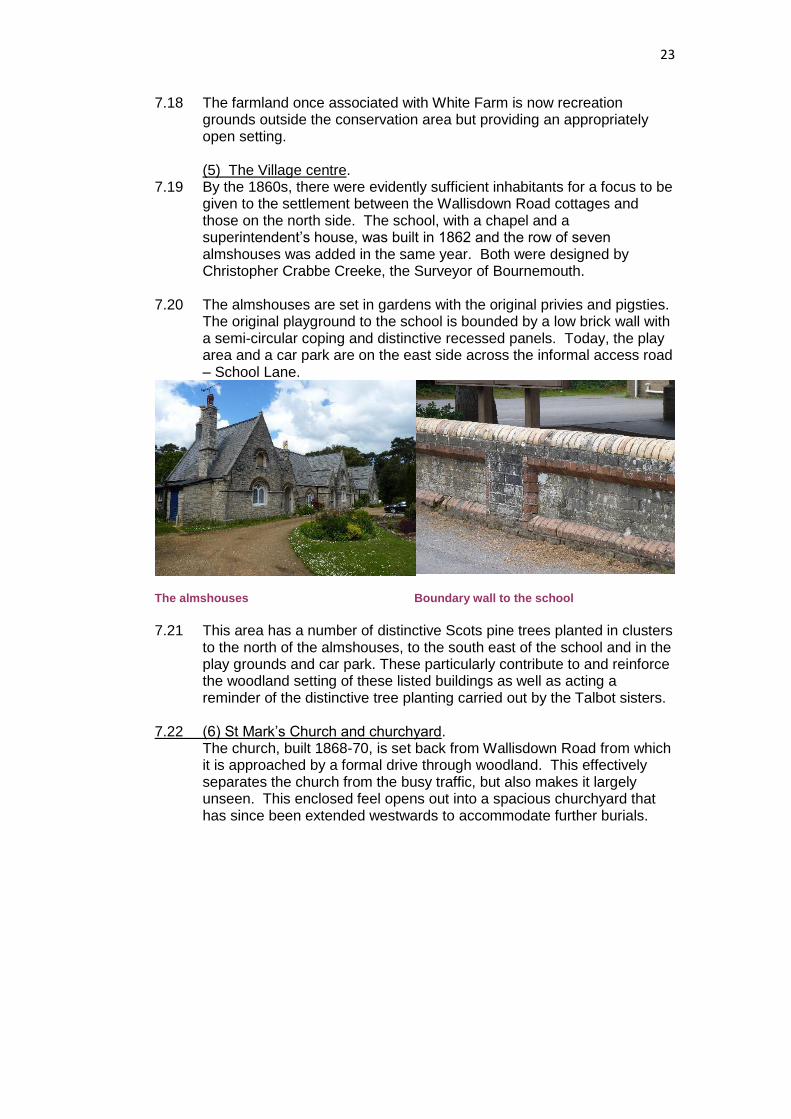
7.19 By the 1860s, there were evidently sufficient inhabitants for a focus to be given to the settlement between the Wallisdown Road cottages and those on the north side. The school, with a chapel and a superintendent’s house, was built in 1862 and the row of seven almshouses was added in the same year. Both were designed by Christopher Crabbe Creeke, the Surveyor of Bournemouth.
7.20 The almshouses are set in gardens with the original privies and pigsties. The original playground to the school is bounded by a low brick wall with a semi-circular coping and distinctive recessed panels. Today, the play area and a car park are on the east side across the informal access road – School Lane.
The almshouses Boundary wall to the school
7.21 This area has a number of distinctive Scots pine trees planted in clusters
to the north of the almshouses, to the south east of the school and in the play grounds and car park. These particularly contribute to and reinforce the woodland setting of these listed buildings as well as acting a reminder of the distinctive tree planting carried out by the Talbot sisters.
7.22 (6) St Mark’s Church and churchyard. The church, built 1868-70, is set back from Wallisdown Road from which it is approached by a formal drive through woodland. This effectively separates the church from the busy traffic, but also makes it largely unseen. This enclosed feel opens out into a spacious churchyard that has since been extended westwards to accommodate further burials.

24
7.23 The church was extended in the 20th century on the north side. The extension, which re-orientates the liturgical axis in a north-south direction, has a sweeping expanse of slate roof and a dramatic stained glass window in the north gable end. A linked church hall has also been added on the west side creating a complex that hosts a lively programme of events as well as church services.
Formal layout of the churchyard
7.24 The formal layout of the graveyard focuses on an ornamental cross that
commemorates Georgina Talbot. Her sister is also commemorated with a cross in the approach road. (7) Paddock and allotments.
7.25 The paddock survives from the original farmland and is still used for horses. It contributes to the openness of the churchyard and to the rural character of the area. It is defined by post and wire fences and views beyond it.
7.26 To the west, an area has been laid out as allotment gardens. These add to the sense of open- ness and provide a buffer to the built up area – a transition between the houses and the paddocks. The use as allotments is also sympathetic to the self-sufficiency ethos of the village. Close to the entrance of the allotments there is a Victorian cast-iron lamp post now converted from gas to electrical supply. (8) The Plantation.
7.27 There are two main areas of woodland. The rectangular area between the churchyard and the school, known as the Plantation, would appear to have been established as a deliberate scenic device at least in its
25
southern part. While the dominant trees are pines, there is also a range of native and non-native species contained by attractive post and rail fences. The Plantation is crossed diagonally by a road linking the church and the school. (9) Albion Woods.
7.28 The other area is that between White Farm and the Wallisdown Road cottages, known as Albion Woods. Here the distinction between what was intended and what has naturally regenerated is blurred, but it is known that Marianne carried out an extensive programme of tree planting after her sister died in 1870 with a high percentage of native species. The woods are crossed by several tracks linking the university area in the south with the housing estates to the north. Some are gravelled but most are unsurfaced. There are also less formal footpaths through the woods and ditches, banks and hedge boundaries dating back at least to the previous use as gravel workings. Architectural and historic qualities
7.29 Modest by some current standards, the cottages were considered generous when first constructed. They are built of brick with slate or tiled roofs. They generally have an attic floor above the ground floor – only two have a full first floor (Nos.58 & 100) – and they tend to have single-storey outbuildings to the side or rear.
7.30 The picturesque style comes from pattern book designs, such as those
of John Loudon, which used often exaggerated historical motifs. Particularly distinctive are the L-shaped plans with the entrance set diagonally across the angle.
7.31 Windows are timber mullioned casements with diamond leaded lights.
They are typically three lights wide with transoms on the ground floor and two lights wide above. Some have hood-mouldings and there are also canted bays with tiled roofs.
Typical casement windows with mullions L-shaped plan with ornamental chimneys and and transoms dividing leaded lights fish-scale tiles
7.32 The steeply pitched roofs have overhanging eaves with exposed rafter
feet and gabled dormers. They often have courses of fish-scale tiles. Chimney stacks are prominent and some are diagonally set to give ornamental qualities.
26
7.33 Porches add to the rustic character. Some take the form of catslide roofs supported on posts, while another variation infills the angle of an L-shaped plan. The timber doors generally have tall narrow panels.
7.34 For public buildings, such as St Mark’s Church and the almshouses,
stone is used to emphasise their higher status. The stone is Purbeck or Portland in the form of squared rubble with ashlar dressings. On the almshouses, the Romanesque style is enhanced with semi-circular arches of brick that contrast with the stonework.
7.35 The school is built of buff brickwork with architectural detailing achieved
through the extensive use of specially shaped bricks in contrasting colours. The complex has a range of large slate roofs and dramatically tall windows to light the larger spaces. Plaques, now set in a front extension record that the school ‘was built by G G Talbot 1862 and endowed by M A Talbot 1903’, presumably when it was first extended.
Romanesque arches on the almshouses Commemorative plaques on the school
Trees, planting and green spaces 7.36 It is apparent that the area was fairly barren scrubland until the Talbot
sisters set about land improvements. Even when development was completed in 1870, the church was said to be highly visible. The woodland character of the conservation area has therefore emerged over time through deliberate planting and natural regeneration.
7.37 Clearly, there was an element of strategic tree-planting, particularly of
Scots pines, as is widely prevalent across the Bournemouth area. A notable example is the prominent group of pine trees between the school and the car park. There is also evidence of deliberate planting in the Plantation and in the Albion Woods to the east of the school, and it is known that Marianne was responsible for much of this.
7.38 Recorded species include oak, sycamore, Scots pine, holly, holm oak,
hawthorn, rowan, prunus, silver birch, laurel, sweet chestnut, yew and Norway maple. However, it is clear that a good deal of the woodland is self-seeded regeneration of species such as sycamore.
7.39 The churchyard includes specimen trees and box hedges to emphasise
the formal plan. Private gardens vary considerably from intensive flower gardens to informal woodland glades. There is little evidence that the original ideals of self-sufficiency are being upheld on any notable scale.
27
7.40 All of the woodland area at Talbot Village is protected by a ‘Woodland’ or ‘Group’ Tree Preservation Order (TPO). Woodland TPOs protect all trees whatever their size on the day the order was made and all the trees that have grown since. Group TPOs protect trees within a defined group that were present on the day the order was made, or they can cover individually identified trees within the group.
A group of Scots pines by the school Specimen trees in the churchyard
The public realm
7.41 It is significant to the rural character of the conservation area that the lanes and paths are not adopted. Instead, they are owned and maintained by the Talbot Village Trust, which means that smooth tarmac surfaces edged with formal kerbs have been largely avoided to good effect. The gravel tracks identify what the characteristic surfacing is.
7.42 There are a number of footpath entrances to the village, as well 2 main
ones for vehicles – to serve the church and the rest of the village including the school. The key gateways are from the roundabout on Wallisdown Road and from the open space at Slades Farm.
7.43 Street furniture is very limited, again in keeping with the informal
character. There is the gas lamp-standard on Alton Road, the marker stone at its junction with Wallisdown Road and a cast-iron letter box near No.156 Wallisdown Road. There is also a distinctively designed granite bench in the churchyard inscribed to commemorate the Queen’s Diamond Jubilee in 2002.
7.44 Property boundaries follow status and character. The school has a substantial brick wall with recessed panels, while the cottages have picket fences and post-and-rail fences but mostly dense hedges. Less successful are the use of chestnut paling or the chainlink fencing between White Farm and Boundary Road.
Jubilee ben

28
Bench in St Mark’s Churchyard Chestnut paling
General condition of buildings 7.45 The buildings are well maintained. The cottages are all in the ownership
of the Talbot Village Trust and they have therefore benefitted from being maintained to a similar standard and in a similar way. This has helped to uphold the visual coherence of the village. The exception is White Farm, which is not in productive use and is occupied on a caretaker basis. This has led to an air of neglect and decay, but solutions for the future are being sought.
29
Figure 10. Spatial and Character Analysis Summary Map
30
8. Contribution of Buildings Listed buildings
8.1 The fact that so many of the buildings in the conservation area are statutorily listed confirms the high quality of the area. There are 25 listed buildings comprising: St Mark’s Church Two churchyard crosses – memorials to the Talbot sisters The Talbot Village School The Almshouses White Farmhouse The storehouse/barn at White Farm 18 cottages
Full details of these buildings are provided on Historic England’s website.
8.2 The listed status means that both the inside and the outside of the buildings is important and needs to be safeguarded. The setting of these buildings should also be protected. Positive buildings
8.3 Positive buildings are those that make a positive contribution to the character of a conservation area. Listed buildings, by definition, have special architectural or historic interest and are, therefore, considered to be positive. However, there may be other heritage assets that the Council would wish to see retained – this could include boundary walls.
8.4 In this case, most of the buildings in the conservation area are listed.
There is only one exception: the vicarage at No.20 Alton Road. This is a testament to the enduring quality of the original concept of Talbot Village and the importance the buildings have nationally.
8.5 The Vicarage was built in 1934 in a sympathetic red brick with classical
references particularly in the two-storey porch and the gate piers. It adds to the established qualities of the conservation area.
Positive building - The Vicarage, Alton Road
31
Neutral buildings 8.6 Neutral buildings neither enhance nor detract from the conservation
area. This is usually because they are of a later date and style and do not, therefore, define the prevailing character.
8.7 There are no neutral buildings within Talbot Village as all are either listed
or otherwise positive as described above. There are some elements or additions to listed buildings that are neutral in character; for example, the more recent buildings – the church hall and the rear extensions to the school – are well-detailed but functional. They were evidently designed so that they would not compete with the listed buildings to which they are attached. By their discreteness, they do not detract from the character while they certainly add to the vitality of the village.
Negative buildings
8.8 Negative buildings detract from the character or appearance of the conservation area. No buildings by virtue of their design or construction are negative within Talbot Village. There are concerns however, about the condition of the buildings at White Farm which detract from the otherwise well maintained quality of the area (see section 7).
9. Boundary review 9.1 The extent of the conservation area is defined by the core of the Talbot
sisters’ estate that survives following the disposal of land to the north for recreation grounds and to the south for the universities and for development of the modern Talbot Village housing estate. While the recreation grounds are pleasant, they are not considered to have the special qualities that would warrant inclusion within the designated area.
9.2 The conservation area boundaries have been carefully reconsidered in
the course of this appraisal, and there is just one proposed amendment. A small square area on the east side of White Farm was once clearly related to the farmhouse and outbuildings (see map at Figure 8). Today, it clearly relates more properly to the playing fields beyond. It is also designated as school playing fields for planning policy purposes. It is suggested that this small area should be deleted from the conservation area designation. The proposed change is shown on the map at Figure 9.
10. Management Issues and Challenges
10.1 While most of the conservation area benefits from common ownership,
and therefore common standards, there are a number of issues arising
from the appraisal of the area’s character that raise opportunities that
can be addressed through future management. These are expressed in
the following series of themes. They are then considered in more detail
in a companion document, the Talbot Village Conservation Area
Management Plan.
32
Strategic issues
10.2 These issues concern the role of Talbot Village in a modern urban
context:
Retaining a rural character in an urbanised setting
The current role of the original charitable intentions for the Village
The interests of other stakeholders, such as the universities and the
local authority
Organisational issues
10.3 These are the practical matters affecting management and maintenance,
such as:
The adoption of standards and expectations
The assignment of responsibilities between owners and occupiers
The involvement of other agencies, such as the local authority
Raising wider awareness of the special interest
Planning Policy and control
10.4 The planning regime can be used for the benefit of the area by:
Controlling heritage assets to maintain their special interest
Updating specific development plan policies
Managing the protection of trees
Addressing buildings-at-risk
Identifying opportunity sites and both the scope and the constraints
for new development
Economic issues and opportunities for development
10.5 The current delivery of charitable purposes has inevitably evolved from
the original intentions of the Talbot sisters. Implications for the character
of the conservation area include:
Occupation and use
Costs of building maintenance
Costs of environmental management
Potential for new development to secure the long-term future of the
village
Spatial Issues
10.6 These issues address the management of the more public areas. They
include:
Controlling tree cover both in terms of its extent and the need to
avoid over-maturity through succession planting
Maintaining appropriate surfacing for the lanes, footpaths and car
park areas
Deciding whether there should be any lighting of the public realm
Defining expectations for property boundaries
Safeguarding the setting of the conservation area through the
development process and traffic management and or public
realm/road improvements
33
Site specific issues
10.7 These include:
Establishing a viable future for White Farm and its associated
buildings
Ensuring that the needs of the school, its playground and the car
park are accommodated without detracting from the character of the
conservation area
Maintenance and planting in the churchyard
11. Community Involvement 11.1 Involving local communities and raising public awareness are essential
to the review of conservation areas and producing character appraisals.
Accordingly, public consultation will be undertaken on the draft Talbot
Village Conservation Area Appraisal (and accompanying Management
Plan) for a six week period.
11.2 It is intended that publicity and public engagement will include:
An exhibition and ‘drop in surgery’
Letters, emails or other contact with all properties within the
conservation area and major stakeholders
Press releases prepared for local media to report
Site notices erected within the conservation area
Use of the Council website, Facebook and Twitter
Copies of the appraisal made available for viewing at the Council’s
offices and local library
11.3 A report of consultation, explaining how responses have been taken into account, will be published separately.

34
Appendix 1
Properties within the Conservation Area Alton Road: 20 Wallisdown Road: 28, 38, 48, 58, 88, 100, 112, 122, 132, 142, 150, 156,
190,198, St Mark’s Church, Cottages: Lulworth, Rose, Myrtle, Pleasant Other: St Mark’s Primary School, 1-7 Almshouses, White
Farm
Appendix 2 Current planning policy wording Key ‘Saved’ Bournemouth District Wide Local Plan (2002) policies Policy 4.4 “Development proposals in conservation areas should preserve or enhance the character or appearance of the area. In determining applications for development, the Local Planning Authority will have regard to the following:
i) Scale, density, height, form, massing, layout, materials, colours, vertical or horizontal emphasis and detailed design of the proposed development in relation to the predominant character of buildings in the area or, in the case of extensions, to the character of the principal building;
ii) Retention of the original building plots where their relationship with the pattern of development and other plots makes a contribution to the character or appearance of the conservation area.
iii) Protection of existing street patterns, open spaces, trees, hedgerows, walls, views and other elements which are an integral part of the conservation area.”
Policy 4.12 “The Local Planning Authority will seek to protect Talbot Village from further development except for dethatched dwellings and improvements to the modern school buildings. The dwellings shall be sited within spacious plots of similar size to those existing and shall be of a size, scale and character sympathetic to the listed buildings and shall, together with landscaping, preserve or enhance the character of the conservation area. There shall be a maximum of 6 new dwellings sited as follows: By Alton Road 2 By Wallisdown Road 1 Land adjacent to White Farm Close 3 Improvements or extension to modern buildings of the school shall only be permitted if the setting of the original listed school building is enhanced. The construction of kerbs, provision of street lighting and extension road lengths will not be permitted.”

35
Key Local Plan Core Strategy (2012) Policy
Policy CS39
“The Local Planning Authority will seek to protect designated heritage assets from demolition, inappropriate alterations, extensions or other proposals that would adversely affect their significance. Proposals for development likely to result in substantial harm to, or loss of, Grade II listed buildings or parks and gardens will only be approved in exceptional circumstances, and for a Grade I or II* listed buildings or parks and gardens only in wholly exceptional circumstances. “Where a proposal for alteration, extension or demolition is likely to affect a
designated heritage asset or its setting, the developer will be required to submit
an assessment of that asset and indicate the impact of the proposal on the
asset.”
Note: A Conservation Area is a designated heritage asset.