take it outside! the next ten years - parks.traviscountytx.gov · manor austin walter e. long lake...
TRANSCRIPT
...take it outside! The Next Ten Years
The mission of Travis County Parks is to provide places where people recreateoutdoors for their health and wellbeing, where they relax, enjoy family and friends,and engage with their community, where regardless of their age and abilities theychallenge themselves and play hard, and where they and generations to comeenjoy the many wonderful natural and cultural resources of Travis County.
Travis County‘s new system-wide parks master plan provides a framework forrealizing this mission as the county population continues to grow over the nextdecade. The plan identifies land acquisition priorities, types of parks to be built,and recreational facilities to be provided. It establishes capital improvementpriorities that are to be implemented primarily with voter-approved bonds.
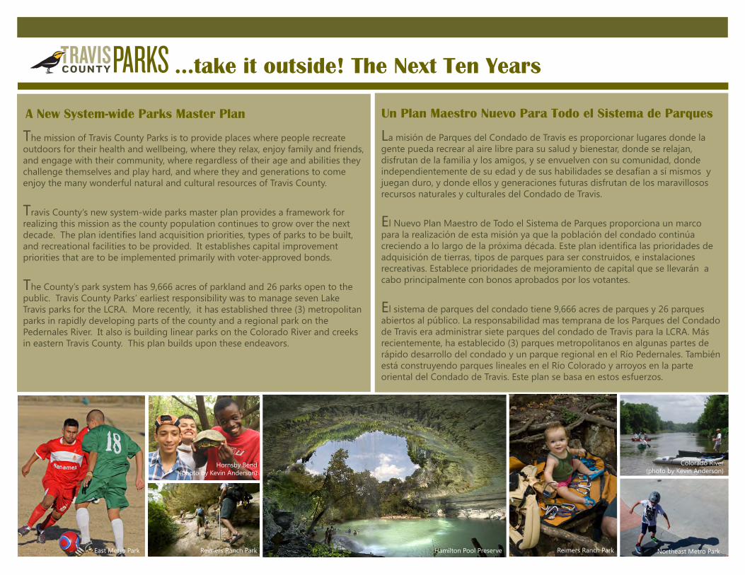
The County’s park system has 9,666 acres of parkland and 26 parks open to thepublic. Travis County Parks’ earliest responsibility was to manage seven LakeTravis parks for the LCRA. More recently, it has established three (3) metropolitanparks in rapidly developing parts of the county and a regional park on thePedernales River. It also is building linear parks on the Colorado River and creeksin eastern Travis County. This plan builds upon these endeavors.
A New System-wide Parks Master Plan
East Metro Park Hamilton Pool Preserve
Hornsby Bend(photo by Kevin Anderson)
Reimers Ranch Park
Colorado River(photo by Kevin Anderson)
Reimers Ranch Park Northeast Metro Park
La misión de Parques del Condado de Travis es proporcionar lugares donde lagente pueda recrear al aire libre para su salud y bienestar, donde se relajan,disfrutan de la familia y los amigos, y se envuelven con su comunidad, dondeindependientemente de su edad y de sus habilidades se desafían a sí mismos yjuegan duro, y donde ellos y generaciones futuras disfrutan de los maravillososrecursos naturales y culturales del Condado de Travis.
El Nuevo Plan Maestro de Todo el Sistema de Parques proporciona un marcopara la realización de esta misión ya que la población del condado continúacreciendo a lo largo de la próxima década. Este plan identifica las prioridades deadquisición de tierras, tipos de parques para ser construidos, e instalacionesrecreativas. Establece prioridades de mejoramiento de capital que se llevarán acabo principalmente con bonos aprobados por los votantes.
El sistema de parques del condado tiene 9,666 acres de parques y 26 parquesabiertos al público. La responsabilidad mas temprana de los Parques del Condadode Travis era administrar siete parques del condado de Travis para la LCRA. Másrecientemente, ha establecido (3) parques metropolitanos en algunas partes derápido desarrollo del condado y un parque regional en el Río Pedernales. Tambiénestá construyendo parques lineales en el Río Colorado y arroyos en la parteoriental del Condado de Travis. Este plan se basa en estos esfuerzos.
Un Plan Maestro Nuevo Para Todo el Sistema de Parques

Park Development Concepts
Regional Parks and PreservesRegional parks and preserves that are at least 200 acres are preferred over smallertracts for the benefits derived from the larger size.- Nature-based recreational opportunities are increased- Natural drainage patterns are preserved and groundwater recharge is maximized- Fragmentation of ecosystems and wildlife habitat is reduced- Rural landscapes and vistas are preserved- Maintenance operations are consolidated
Greenways and River CorridorsGreenways along waterways are preferred land configurations because of thebenefits derived from their linear shape.- Extended, connected trail systems can be developed- Impacts of stormwater and runoff on water quality are attenuated- Flood damage is mitigated- Wildlife corridors are established- Rural landscapes and views are preserved
Parkland Acquisition Priorities- Floodplains and Low Terraces- Pedernales River Corridor- Post Oak Savanna and Bluffs- Significant Natural Springs and Water Features
Acquisition Strategies- Voter-approved Bonds- Parkland Dedications- Federal and State Grants- Floodplain Buy-outs- Donations
Floodplain and Low Terraces
...take it outside! The Next Ten Years
Pedernales River Corridor
Colorado River below confluence with Onion Creek
Onion Creek Bottomland Woods Colorado River
Pedernales River
Reimers Ranch Park Reimers Ranch Park

Natural Springs and Water Features
Post Oak Savanna and Bluffs (insert Spanish)
...take it outside! The Next Ten Years was reviewed by the public in the spring of 2016 and adopted by the Travis County Commissioners Court on August 9, 2016
Post Oak Savanna Bluff
Pogue Springs
View to Post Oak Savanna Post Oak
Pedernales River at Hamilton Creek
Hamilton Pool
Parques y Reservas RegionalesParques y reservas regionales de por lo menos 200 acres son preferibles a lasextensiones más pequeñas por los beneficios derivados de mayor tamaño - Oportunidades recreacionales basados en la naturaleza se incrementan- Los patrones naturales de drenaje se conservan y la agua subterránea se máximiza - La fragmentación de los ecosistemas y hábitat de la vida silvestre se reducen- Las operaciones de mantenimiento se consolidan
Vías Verdes y Corredores de Río Las vías verdes a lo largo de los canales son configuraciones preferidas de la tierradebido a las ventajas derivadas de su forma lineal. - Sistemas de senderos extendidos, conectados se pueden desarrollar- Los impactos de las aguas de tormenta y de escorrentía sobre la calidad del agua se atenúan- Daños por inundaciones se mitigan- Se establecen corredores de vida silvestre - Paisajes rurales y puntos de vista se conservan
Prioridades de Adquisición de Zonas Verdes - Planicies de Inundación y Terrazas Bajas- Corredor del Río Pedernales- Post Oak Sabanna y Bluffs- Manantiales Naturales y Características de Agua Significantes
Estrategias de Adquisición- Bonos aprobados por los votantes- Dedicaciones de Zonas Verdes- Subsidios Federales y Estatales- Compras de Planicies de Inundación - Donaciones
Conceptos de Desarrollo de Parques
…¡Llévalo afuera! Los Próximos Diez Años fue revisado por el público en la primavera de 2016 y adoptada por la Corte de Comisionados del Condado de Travis el 9 de agosto de 2016

SShh
ooa a
l lCC
rreeeekk
WWiillbbaarrggeerr CCrreeeekk WWiill
llooww CCrreeeekk
EEll mmCCrreeeekk
WWee
ll llss
BBrra
ann
cchh
CCoo
t tt to onn
wwoo
oodd
CCrree
eekk
CCoo
lleemm
aann
BBrraa
nncchh
LLii tt
tt llee
WWiill
llooww
CCrre
eee
kk
LLiittttllee
WWaa
llnnuu
tt
CCrreeeekk
WWaa
llnn
uuttCC
rreeee
kk
GGiilllleellaanndd CCrreeeekk
CCoottttoonnww
ooooddCCrreeee
kk
DDeecckkeerrCC
rreeeekk
DDrry
y
CCrreeeekk
HHaarrrriiss BBrraanncchh
CCrreeeekk
DDrryy CCrreeeekk
WWaa
llllee
rrCC
rreeeek
k
FFoo
rrtt
BBrraanncchh
CCrree
eekk
TTaa
nnnn
eehhiill
l lBB
rraann
cchh
CCrr
eeeekk
") 969
")1325
UV 1
PFLUGERVILLEPFLUGERVILLE
ELGINELGIN
WEBBERVILLEWEBBERVILLE
ROUNDROUND
ROCKROCK
MANORMANOR
AUSTINAUSTIN
Walter E.
Long Lake EastEastMetropolitanMetropolitanParkPark
WildhorseWildhorse
WhisperWhisperValleyValley
GillelandGilleland
CreekCreek
GreenwayGreenway
Ben E.Ben E.FisherFisher
ParkPark
BlueBlueBluffBluffParkPark
Colorado River CorridorColorado River Corridor
LittleLittleWebbervilleWebbervilleParkPark
WebbervilleWebbervilleParkPark
WilbargerWilbargerCreekCreekGreenwayGreenway
Post OakPost OakSavanna & BluffsSavanna & Bluffs
TO BE NAMEDTO BE NAMED
GreenwayGreenway
FM 973FM 973CrossingCrossing
NortheastNortheastMetropolitanMetropolitan
ParkParkBASTROPBASTROP
North
east
Pla
nn
ing A
rea C
on
cept
Pla
n -
by C
om
mis
sio
ner P
recin
cts
North
east
Pla
nn
ing A
rea C
on
cept
Pla
n -
by C
om
mis
sio
ner P
recin
cts
CCoo
lloorraa
ddoo RRiivveerr
0 2 41 Miles
.
Incorporated Areas
Travis County Parks
DISCLAIMER: This product is for informational purposes and may not have been prepared for or be suitable for legal, engineering, or surveying purposes. It does not represent an on-the-ground survey and represents only the approximate relative location of property boundaries. Travis County has produced this product for reference purposes only and offers no warranties for the product’s accuracy or completeness.Created On: September 29, 2016
Greenway/ Corridor AreasProjected Dedications
6
Post Oak Savanna
4
8
2
1
3
7
5
1Complete parkland acquisition for
Gilleland Creek Greenway
2Develop Gilleland Creek trail &
other recreational facilities
3 Renovate Ben E. Fisher Park
4Acquire parkland for Colorado
River Corridor
5Acquire parkland for Wilbarger
Creek Greenway
6Acquire parkland for TO BE
NAMED Greenway
7Acquire Post Oak Savanna &
adjacent bluffs
8Develop boat ramp at FM 973
crossing
9Acquire strategic parkland
(location to be determined)
Implementation Priorities for NE
Planning Area
Other Conserved Land(Other Jurisdiction Parkland, &
Travis County Non-BCP
Conservation Easement Properties)
Precinct 1 Parks
Precinct 2 Parks
Note: This map has been revised to
reflect Travis County parkland that has
been acquired as of September 2016.

MMaa hh
aaCCrr
eeeekk
DDrryy CCrreeee
kk
MMaarrbblleeCCrreeeekk
BBlluunnnnCCrreeeekk
BBeeaarr CCrreeeekk
CCoowwppe
enn CCrreeeekk
SSoouutthh
FFoorrkkDDrryy CCrreeeekk
EEaassttBBoouullddiinnCCrreeeekk
BBooggggyy CCrreeeekk
RRiinnaarrddCCrreeeekk
WWeessttBBoouullddiinnCCrreeeekk
OOnniioonn CCrreeeekk
UV 1
Del ValleDel ValleSoftballSoftball
ComplexComplex
BarkleyBarkleyMeadowsMeadowsParkPark
TimberTimberCreekCreekParkPark
SoutheastSoutheastMetropolitanMetropolitanParkPark
Richard MoyaRichard Moya
ParkPark
ManchacaManchacaGardensGardens
ParkPark
Onion CreekOnion CreekGreenwayGreenway
ColoradoColoradoRiverRiver
CorridorCorridor
DryDryCreekCreekGreenwayGreenway
A B I AA B I A
Sou
theast
Pla
nn
ing A
rea C
on
cept
Pla
n -
by C
om
mis
sio
ner P
recin
cts
Sou
theast
Pla
nn
ing A
rea C
on
cept
Pla
n -
by C
om
mis
sio
ner P
recin
cts
BASTROPBASTROP
HAYSHAYS
CALDWELLCALDWELL
CCoolloorraa
ddooRRiivveerr
0 2 41 Miles .Created On: September 06, 2016
12
3
5
4
1Complete parkland acquisition for
Onion Creek Greenway
2Complete Onion Creek trail &
other recreational facilities
3Acquire parkland for Colorado
River Corridor
4Develop pool/water play area at
Southeast Metropolitan Park
5Acquire parkland for Dry Creek
Greenway
6Acquire strategic parkland
(location to be determined)
Implementation Priorities for SE
Planning Area
ABIA Portion of Greenway Incorporated Areas
Other Conserved Land(Other Jurisdiction Parkland,
Balcones Canyonlands Preserve (BCP),
& City of Austin's Water Quality
Protection Lands)Greenway/ Corridor Areas
Travis County Parks
Precinct 3 Parks
Precinct 4 Parks

SSllaauugghhtteerr CCrreeeekk
GGrraappeeCCrreeeekk
GGaaiinn
eess CC rreeeekk
HHoonn
eeyyCCrree
eekk
BBaarrttoonn
CCrreeee
kk
HHaarrrriissoo
nnHHooll
llooww
FFaallll CCrreeeekk
PPeeddeerrnn
aalleessRRiivveerr
LLiicckkCCrreeeekk
BBeeee
CCrreeeekk
HHuurrssttCCrreeeekk
YYaauuppoonnCCrreeeekk
LLii ttttlleeBBaarrttoonnCCrreeeekk
BBrraanncchh RRoocckkyy CCrreeeekk
RRoocckkyy CCrreeeekk
MMyyrrttlleeCCrreeeekk
TThh
oommaassSSpprriinnggss
TTrraavviiss CC
oouunnttyy CC
rreeeekk
BBaarrttoonn
CCrreeeekk
BBeeeeCCrreeeekk ((WWeessttllaakkee))
UV 1
LAKEWAYLAKEWAY
WESTWEST
LAKELAKE
HILLSHILLS
BEE CAVEBEE CAVE
BRIARCLIFFBRIARCLIFF
THETHE
HILLSHILLS
ROLLINGWOODROLLINGWOOD
SANSAN
LEANNLEANN
AUSTINAUSTIN
ReimersReimersRanchRanchParkPark
Hamilton PoolHamilton PoolPreservePreserve
PacePaceBendBendParkPark
Wild BasinWild BasinPreservePreserve
Loop 360Loop 360Boat RampBoat RampMansfieldMansfield
Dam ParkDam Park
WindmillWindmillRun ParkRun Park
Pedernales RiverPedernales RiverCorridorCorridor
HAYSHAYS
BLANCOBLANCO
Sou
thw
est
Pla
nn
ing A
rea C
on
cept
Pla
n -
by C
om
mis
sio
ner P
recin
cts
Sou
thw
est
Pla
nn
ing A
rea C
on
cept
Pla
n -
by C
om
mis
sio
ner P
recin
cts
BURNETBURNET
LakeLake
TravisTravis
0 2 41 Miles .DISCLAIMER: This product is for informational purposes and may not have been prepared for or be suitable for legal, engineering, or surveying purposes. It does not represent an on-the-ground survey and represents only the approximate relative location of property boundaries. Travis County has produced this product for reference purposes only and offers no warranties for the product’s accuracy or completeness.Created On: September 13, 2016
Hamilton
Hamilton
Creek
Creek
4
1 Southwest Sports Complex
2Acquire parkland for Pedernales
River Corridor
3Develop Reimers Ranch Park
campground & expand trail system
4Improve day use area & develop
campgrounds at Pace Bend Park
5
Acquire strategic Lake Travis
properties (location to be
determined)
Implementation Priorities for SW
Planning Area
1
Incorporated Areas
Other Conserved Land(Other Jurisdiction Parkland, Balcones
Canyonlands Preserve (BCP), & City of
Austin's Water Quality Protection Lands)
2
3
Travis County Parks
Precinct 2 Parks
Precinct 3 Parks

BB
uullll CCrreeee
kk
WWeesstt
BBuullllCCrreeeekk
SSpprriinnggCCrree
eekk
SSuullpphh
uurrCCrreeeekk
PPoosstt
OOaakkCCrreeeekk
CCoolllliieerrHHoollllooww
BBiiggSSaannddyy
CCrreeeekk
LL
iimmeeCCrreeeekk
FFiisshheerr HHoo
llllooww
NNeeggrrooBB
rraanncchh
CCooww
CCrreeeekk
BBeeeeCCrreeeekk
BBiinngghhaammCCrreeeekk
LLoonnggHHoolllloowwCCrreeeekk
CCyypprreessssCCrre eeekk
CCoottttoonnwwooooddBBrraanncchh
BBeeaa
rr CCrreeeekk
CCooww FFoorrkk BBuullll CC rreeeekk
£¤183
")1325
UV 1
LAGOLAGO
VISTAVISTA
LEANDERLEANDER
VOLENTEVOLENTE
POINT POINT
VENTUREVENTURE
CEDARCEDAR
PARKPARK
JONESTOWNJONESTOWN
AUSTINAUSTIN
Hamilton PoolHamilton Pool
t Rampp
ArkansasArkansasBend ParkBend Park
Hippie Hollow ParkHippie Hollow Park
BobBobWentzWentz
ParkPark
SandySandyCreekCreekParkPark
CypressCypressCreekCreekParkPark
Tom HughesTom HughesParkPark
FritzFritzHughesHughesParkPark
DinkDinkPearsonPearsonParkPark
SelmaSelmaHughesHughesParkPark
MaryMaryQuinlanQuinlanParkPark
AllenAllenMemorialMemorial
ParkPark
NamelessNamelessSchool/ CemeterySchool/ Cemetery
HoneycombHoneycomb
Hills ParkHills Park
Trails EndTrails End
PreservePreserve
North
west
Pla
nn
ing A
rea C
on
cept
Pla
n -
by C
om
mis
sio
ner P
recin
cts
North
west
Pla
nn
ing A
rea C
on
cept
Pla
n -
by C
om
mis
sio
ner P
recin
cts
LakeLake
TravisTravis
0 2 41 Miles .
WILLIAMSONWILLIAMSON
BURNETBURNET
DISCLAIMER: This product is for informational purposes and may not have been prepared for or be suitable for legal, engineering, or surveying purposes. It does not represent an on-the-ground survey and represents only the approximate relative location of property boundaries. Travis County has produced this product for reference purposes only and offers no warranties for the product’s accuracy or completeness.Created On: September 06, 2016
Incorporated Areas
1
2 3
1 Develop Trails End Preserve
2 Improve Bob Wentz Park facilities
3 Improve Hippie Hollow Park entrance area
4 Acquire strategic Lake Travis properties
(location to be determined)
Implementation Priorities for NW Planning Area
Other Conserved Land(Other Jurisdiction Parkland, Balcones
Canyonlands Preserve (BCP), U.S. Fish &
Wildlife Preserve Areas, & City of
Austin's Water Quality Protection Lands)
Travis County Parks
Precinct 2 Parks
Precinct 3 Parks

This plan was prepared by Travis County Parks
Steve Manilla, P.E. TNR County Executive Cynthia McDonald, TNR Chief Deputy Charles Bergh, Travis County Parks Director
Robert Armistead, CRCP, MEd, Parks Assistant Director Wendy Scaperotta, MLA, Planning Project Manager Dan Perry, District Park Manager
Tim Speyrer, District Park Manager Dan Chapman, Chief Park Ranger Glen Gilman, Park Land Manager Dan Pacatte, Park Forester Sara Dilbert, GIS Analyst
Northeast Metro Park
Northeast Metro Park
Northeast Metro Park
Northeast Metro ParkReimers Ranch Park Reimers Ranch Park2016 Travis County Commissioners Court
For more information about Travis County park master plans go to https://parks.traviscountytx.gov
Travis County Commissioners Court
Sarah EckhardtCounty Judge
Ron Davis Brigid SheaCommissioner, Pct.1 Commissioner, Pct 2
Gerald Daugherty Margaret J. GomezCommissioner , Pct. 3 Commissioner, Pct. 4
All photos provided by Travis County Parks unless otherwise specified