tagging of pacific pelagics (topp) · 2010-06-15 · tagging of pacific pelagics (topp) dr. barbara...
TRANSCRIPT
Tagging of Pacific Pelagics (TOPP)
Dr. Barbara Block Stanford University
Department of Biological Sciences Hopkins Marine Station Pacific Grove, CA 93950-3094
Phone: (831) 655-6236 Fax (831) 375-0793 E-mail: [email protected]
Dr. Daniel P. Costa Ecology Evolutionary Biology
University of California, Santa Cruz Long Marine Lab
100 Shaffer Rd Santa Cruz, California USA 95060-5730
Phone: (831) 459-2786 Fax: (831) 459-3383 E-mail: [email protected]
Donald Kohrs Stanford University
Department of Biological Sciences Hopkins Marine Station Pacific Grove, CA 93950-3094
Phone: (831) 655-6225 Fax : (831) 375-0793 E-mail: [email protected]
Education and Outreach Network Liaison Randy Kochevar
AD2 Phone: (831)236-0728 E-mail: [email protected]
http://www.toppcensus.org/
1. 2006 ACCOMPLISHMENTS & SCIENTIFIC HIGHLIGHTS
During the past 12 months, efforts have continued for tag deployments and on improving electronic tag technologies available to marine researchers. Advances in electronic tag technology have provided TOPP with the tools necessary to address fundamental questions in biological oceanography concerning the distribution and assessment of the critical habitats of pelagic organisms. This information is now being applied to describe the movements and behaviors of marine vertebrates and large squid in the North Pacific and to identify hotspots and migratory corridors. The tag-bearing animals continue to serve as autonomous ocean profilers providing key oceanographic data to the growing global databases. The vertical and horizontal movements of tagged marine vertebrates have provided the sampling of more remote, traditionally undersampled oceanic areas, as well as providing unprecedented temporal and spatial coverage of the North Pacific. To date, over 2,500 tags have been deployed and several million ocean observations have been documented. Efforts to database the entire TOPP data set are on-going and new collaborations with JPL-NASA for assimilation of the data have been established.

SCIENTIFIC ACTIVITIES Elephant Seals: Elephant seals are remarkable for their capacity to oceanographically sample the North Pacific and to provide a high return on tag investment due to the ease of release and recapture. Moreover, they spend 10 months out of the year at sea and 90% of that time is below the surface. Elephant seals also have a long history of study with electronic tags so they have a proven track record of ocean sampling. Elephant seals are also interesting from the perspective that the sexes forage in different regions of the North Pacific. Females travel into the open ocean along the North Pacific Current, whereas males remain along the shelf as they head north to the Aleutian Islands. Both sexes travel within the California Current during part of their migration.
Over the past year, we have tracked elephant seals from two breeding colonies: 1) San Benitos Islands, Baja, Mexico, and 2) Año Nuevo, California. These two colonies span the entire known breeding range of northern elephant seals – a distance of 1,200 km (or ~750 miles). Tracking seals from the extant range will provide a more complete understanding of the foraging ecology of this species throughout the North Pacific. In mid-August, Patrick Robinson (UCSC) and Dan Crocker (Sonoma State Univ.) joined an effort lead by Juan Pablo Gallo (CIAD Guaymas, Mexico) on San Benitos Island, where they equipped 5 male elephant seals for the post-molt migration. These seals were equipped with SMRU CTD tags. Male elephant seals typically range along the continental shelf/break waters on the northward migration. This effort was the first time that dive data has been collected on male elephant seals from Mexico. Preliminary analyses indicate that there are distinct differences in at-sea behavior between the seals at both colonies. For example, some seals from the southern rookery (Baja) remained near the tagging location and avoided the long northward migration. The seals that conducted the long trip northward, gained less body mass than their counterparts from the northern rookeries (Año Nuevo), which is undoubtedly linked to the longer foraging migrations.
Currently, there are 36 elephant seals being tracked from San Benitos Islands and Año Nuevo. Historically, all seals from Año Nuevo traveled to the Aleutian Islands or to the central North Pacific. However, this year a female seal surprised researchers and remained within Monterey Bay for several months. One possible explanation for her aberrant behavior is the recent influx of Humboldt squid into Monterey Bay. Based on the location data, this seal spent most of her time in the same general area where the squid have been documented and interestingly her mass gain was slightly above the average for all females this past breeding season.
TOPP researchers are now using Fastloc GPS tags on female elephant seals (Fig. 1). These tags are currently producing up to 57 extremely accurate seal locations per day, which equates to a geoposition after every second dive. The increased frequency of geoposition recording will yield a much finer temporal and spatial resolution of foraging behavior than was previously possible.

California Sea Lions: California sea lions are excellent samplers of the California Current because they generally remain within 100-200 km of the coast and range from Washington State to Baja, Mexico, covering the extent of the California Current. TOPP researchers are studying sea lions in Monterey Bay, San Nicholas and San Miguel Islands, and on small islands in the Gulf of California, Mexico.
Stella Villegas, a Mexican student working in the Costa lab (UCSC) lead a team to Granito Island in the Sea of Cortez, Mexico to tag 10 adult female sea lions. Each sea lion was equipped with a SPOT5 PTT, Mk9 TDR, and HTR stomach temperature recorder for a total of 20-25 days. Given the unique oceanography in the Sea of Cortez, the research team expected the behavior of the sea lions to be different from those studied in California. Although 10 sea lions were successfully tracked, only 5 animals were recaptured. Due to an earlier-than-anticipated molt, many of the instruments fell off prior to recovery, and some of these were found on the beach. In total, 4 PTTs, 7 TDRs, and 4 HTR loggers were recovered. Data show that some of the animals made trips out to deep waters in the middle of the gulf. Analyses are under way to compare the diving behavior and at-sea distribution of these sea lions to those studied in California and Los Islotes, another island south of Granito in the Sea of Cortez. Ultimately, these data will allow a comparison between sea lions foraging off San Nicholas Island, Southern California and the Sea of Cortez, as well as the sea lions foraging off of the Galapagos Islands.
In fall 2005, researchers deployed 34 tags on adult male and female California sea lions at three locations within the California Current system including adult males in Monterey Bay, and adult females on San Nicolas and San Miguel Islands, in the Channel Islands. These deployments provided the requisite data for a more complete population level analysis of foraging behavior and habitat use of California sea lions. Given our previous tracking effort over the last 3 years, it is now possible to make inter-annual comparisons. In winter 2003-04, adult male sea lions remained close to the California coast and the durations of their foraging excursions averaged 12 hours with adult male sea lions feeding almost exclusively over the continental shelf during trips lasting only 0.8 days. This pattern markedly contrasts with
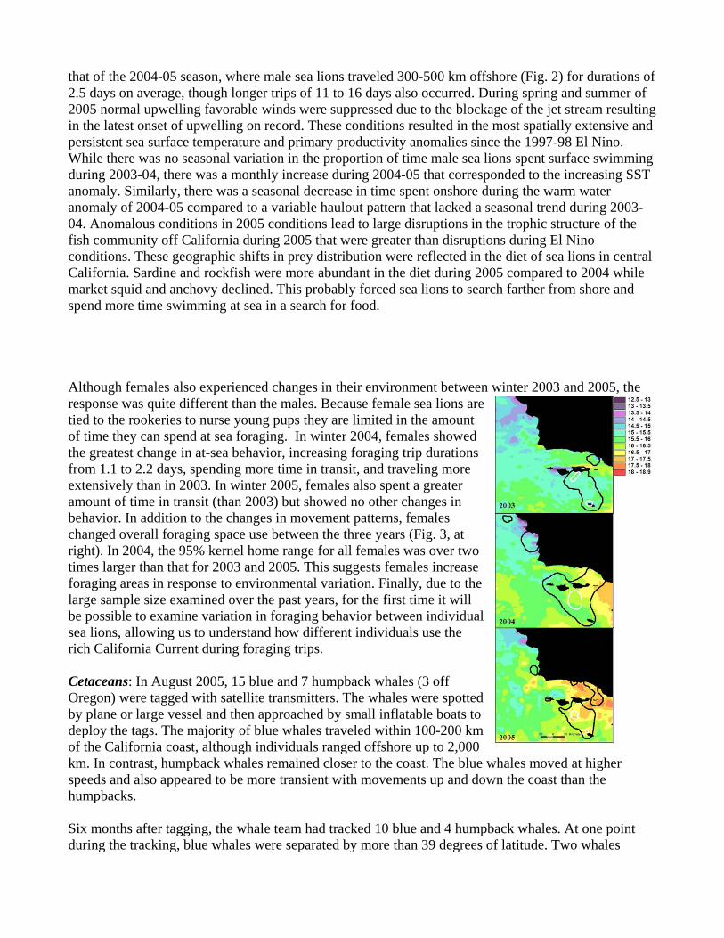
that of the 2004-05 season, where male sea lions traveled 300-500 km offshore (Fig. 2) for durations of 2.5 days on average, though longer trips of 11 to 16 days also occurred. During spring and summer of 2005 normal upwelling favorable winds were suppressed due to the blockage of the jet stream resulting in the latest onset of upwelling on record. These conditions resulted in the most spatially extensive and persistent sea surface temperature and primary productivity anomalies since the 1997-98 El Nino. While there was no seasonal variation in the proportion of time male sea lions spent surface swimming during 2003-04, there was a monthly increase during 2004-05 that corresponded to the increasing SST anomaly. Similarly, there was a seasonal decrease in time spent onshore during the warm water anomaly of 2004-05 compared to a variable haulout pattern that lacked a seasonal trend during 2003-04. Anomalous conditions in 2005 conditions lead to large disruptions in the trophic structure of the fish community off California during 2005 that were greater than disruptions during El Nino conditions. These geographic shifts in prey distribution were reflected in the diet of sea lions in central California. Sardine and rockfish were more abundant in the diet during 2005 compared to 2004 while market squid and anchovy declined. This probably forced sea lions to search farther from shore and spend more time swimming at sea in a search for food. Although females also experienced changes in their environment between winter 2003 and 2005, the response was quite different than the males. Because female sea lions are tied to the rookeries to nurse young pups they are limited in the amount of time they can spend at sea foraging. In winter 2004, females showed the greatest change in at-sea behavior, increasing foraging trip durations from 1.1 to 2.2 days, spending more time in transit, and traveling more extensively than in 2003. In winter 2005, females also spent a greater amount of time in transit (than 2003) but showed no other changes in behavior. In addition to the changes in movement patterns, females changed overall foraging space use between the three years (Fig. 3, at right). In 2004, the 95% kernel home range for all females was over two times larger than that for 2003 and 2005. This suggests females increase foraging areas in response to environmental variation. Finally, due to the large sample size examined over the past years, for the first time it will be possible to examine variation in foraging behavior between individual sea lions, allowing us to understand how different individuals use the rich California Current during foraging trips. Cetaceans: In August 2005, 15 blue and 7 humpback whales (3 off Oregon) were tagged with satellite transmitters. The whales were spotted by plane or large vessel and then approached by small inflatable boats to deploy the tags. The majority of blue whales traveled within 100-200 km of the California coast, although individuals ranged offshore up to 2,000 km. In contrast, humpback whales remained closer to the coast. The blue whales moved at higher speeds and also appeared to be more transient with movements up and down the coast than the humpbacks. Six months after tagging, the whale team had tracked 10 blue and 4 humpback whales. At one point during the tracking, blue whales were separated by more than 39 degrees of latitude. Two whales

ventured as far south as Costa Rica. Another whale that has been tracked for more than 16 months repeated much of the previous year's pattern during the fall and winter, with multiple offshore routes during the southward migration. Humpbacks were tracked for longer durations this past season with migration routes extending from California and Oregon to southern breeding areas, including one whale with an extended stay in the Banderas Bay region of Mexico and another venturing farther south off Nicaragua. These new tracks provide the first evidence for the actual route, rate of speed and timing of the south-bound migration for California humpback whales to their breeding areas. Although sample sizes are still limited compared to other TOPP species, there are general patterns emerging about the behavior and habitat use of large whales. In general, blue whales move farther from shore into deeper water than the humpback whales, probably reflecting the differences in diet between the two species. Blue whales feed on euphausids, whereas the humpback whales have a more generalized diet, which includes small schooling fish found predominately near shore. Details of the dive habits from whales tagged in 2004 with depth-monitoring satellite tags have provided multi-week records showing diurnal (between day and night) fluctuations in dive patterns and the first glimpse of variability between dives in different habitat types (near-versus off-shore) for the same individual whales. The efforts of the TOPP whale team have resulted in a dramatic increase in the data available for these two species in the California Current. Demonstrated by reproductive failures for many marine bird species and especially Cassin's auklets, 2006 is the second consecutive year during which the central California coast is experiencing some El Niño-like effects during the spring and early summer. Some birds, including auklets, are especially sensitive to the timing of chicks hatching coinciding with krill availability. Last year, similar conditions had blue whales moving between traditional krill feeding areas much more frequently and spending more time farther from shore until late summer when the krill conditions returned to normal. At that time, blue whales still near shore resumed "normal" movement patterns. Additionally, 19 deployments of suction-cup tags (B-probe) were made in 2005 to examine the underwater behavior and feeding of blue and humpback whales. This included 7 deployments on humpback whales and 12 on blue whales. Tags gathered data on dive depths, underwater position (tilt and roll), and acoustics. In conjunction with these deployments, hydroacoustic surveys were done of prey fields the animals were feeding on. These tags provided new information on the comparative feeding strategies of these two species and also new information on their underwater vocal behavior. Additional humpback and blue whales will be tagged off the California coast with B-probe acoustic tags for depth of dive and acoustic data associated with feeding on both krill and schooling fishes. Good communications between team members will help make operations more efficient and effective in finding whales.
North Pacific Albatrosses: No TOPP species has the ability to sample the ocean quite like the Laysan and black-footed albatrosses. These seabirds can move rapidly over the sea surface at speeds exceeding 100 km h-1 under optimal wind conditions. As a result, they can rapidly cover large expanses of the ocean and respond quickly to changes in oceanic conditions. The rate of tag return is also exceptionally high (>95%). TOPP researchers have been studying albatrosses at two locations: 1) Tern Island, Northwest Hawaiian Islands, and 2) Guadalupe Island, Mexico. The studies at both colonies provide an interesting contrast between one population that feeds primarily in the California Current and the other that feeds predominantly in pelagic waters of the North Pacific Current. TOPP researchers also

recently (June 2006) began tracking black-footed albatrosses at Midway Atoll National Wildlife Refuge, which is 1,200 km northwest of Tern Island. In December 2005, albatross researchers began a fourth consecutive season of tracking at Tern Island, Northwestern Hawaiian Islands. Here, the team recovered 26 of 30 archival geolocation tags deployed in February 2005 and they also conducted another round of tracking using satellite tags. In total, 20 albatrosses (10 Laysan and 10 black-footed) were tracked during the egg incubation phase and another 30 (15 of each species) were tracked during the chick-brooding phase. In addition, 6 black-footed and 4 Laysan albatrosses were equipped with archival GPS tags that recorded highly accurate locations every 10 seconds, providing an astounding 20,000 locations per day over a three day period (Fig. 4 below). Analyses of satellite tracking data obtained during breeding continues to reveal different foraging zones between albatross species with Laysan albatrosses traveling further north than black-footed albatrosses. The data also indicate that both albatross species behaved differently this season compared to previous seasons. The durations of foraging trips were shorter and birds did not travel as far as in previous seasons. Further comparisons with oceanographic data will hopefully shed light on the differences in foraging behavior. In addition to tracking efforts, TOPP researchers also measured energy expenditure of the albatrosses using doubly labeled water. The objectives were to compare the expenditures of both species and to investigate the relationships between foraging costs and behavior as influenced by the environment. Archival tag data analyses are in progress but preliminary analysis shows that both species utilize the entire North Pacific Ocean during the post-breeding phase (July-November). It also appears that both species tend to segregate with Laysan albatrosses favoring the western Pacific and black-footed albatrosses favoring the eastern Pacific. In addition to tracking efforts in Hawaii, another team continued tracking Laysan albatrosses at Guadalupe Island, Baja, Mexico. Forty albatrosses were tracked with satellite tags and 14 Lotek and 7 BAS archival
geolocation tags were recovered after nearly one year of deployment. Another 15 Lotek deployments were made on adults, which we hope to recover next year. In addition, 4 BAS loggers were deployed on 3 yr old Laysan immature birds. We hope to recover these tags next year, if we do, the resulting data will provide additional information on spatial segregation of this nascent Laysan albatross population. As in previous seasons, Laysan albatrosses from Mexico continue to travel northward to the California Current. However, several birds made excursions to pelagic waters further west than previous years. Again, future comparisons with oceanographic data will hopefully shed light on these different behaviors. TOPP researchers also tested new low cost stomach temperature loggers (STL) that determine when birds ingest food (or water) by measuring changes in stomach temperature. This work is similar to technology implemented on the California sea lion and northern elephant seal studies. Adult albatrosses outfitted with satellite and Lotek tags were given (orally) a small 35g pill containing a time series temperature logging devices. STLs were recovered from 9 of 10 tracked birds during the late incubation and early brooding season. Data from successful deployments reveal the time and approximate location that albatrosses consumed food during its trip to sea (Fig. 5 above). In the future, TOPP researchers hope to implement this methodology to further investigate the links between oceanic conditions, and when and where albatrosses find food. At Tern and Guadalupe Islands, researchers collected feather and blood samples to examine stable isotope ratios, contaminant loads, and population genetics. Recent values of stable isotope ratios from Laysan Albatross feather show that Guadalupe birds show bimodal trophic consumption while Central Pacific birds tend to feed at intermediate trophic level. These analyses are currently being run at the Keck Isotope Laboratory at UCSC and are ongoing. Funding continues to be an issue for contaminant analyses, however preliminary analyses are slated to begin this winter. In June 2006, a new project was launched that focused on tracking albatross fledglings. This life history stage is a real mystery because fledglings leave their nests with no parental guidance. Therefore, it is unknown where fledglings go, how they use the ocean to find food, or how the physical environment affects where they go. Partnering with the National Geographic Society and the US Fish and Wildlife Service, TOPP seabird researchers traveled to Midway Atoll National Wildlife Refuge to deploy satellite tags on black-footed albatross fledglings. A total of 10 individual fledglings were equipped with a SPOT5 or Pico-100 satellite transmitting tag. All birds departed the atoll within 2-4 days of being tagged and all are currently between 35-42°N, which is demarked by the North Pacific Current. After initial dispersion, all birds appear to be heading in roughly similar trajectories, suggesting that fledglings are following prevailing wind patterns. We anticipate tracking individuals for up to a year to unravel the mystery of what these birds do and where they go on their maiden voyage to sea.
Shearwaters: TOPP is studying sooty shearwaters, which breed in New Zealand and pink-footed shearwaters that breed in Chile. Both species migrate to the North Pacific and spend May through September along the California coast. In contrast to albatrosses, shearwaters forage below the surface by diving. TOPP researchers are attempting to record the shearwaters’ migration routes, diving behavior, and residency patterns within the North Pacific. These projects are being done through several international partnerships between researchers from the US, France, New Zealand, and Chile involving collaborations among academic, government, and non-profit organizations.

In June-August 2005, TOPP researchers deployed 10 satellite tags on sooty shearwaters in the Monterey Bay. This research differed from our use of archival tags deployed on breeding birds because it provided a more detailed but temporally shorter time series account of habitat use and behavior of sooty shearwaters in California. A team led by researchers from the US Geological Survey and Moss Landing Marine Labs equipped shearwaters with Kiwisat 202 satellite tags. Birds were spot-lighted at night, captured with a dip net, equipped with a tag, and then released at the capture site. The tags were duty cycled to maximize the longevity of operation. Thus, each tag was estimated to transmit locations for approximately 60 days. Nearly all of the birds remained within Monterey Bay or along the northern California coast for the majority of the tracking period. Several birds transited between the inner portion of Monterey Bay and offshore areas outside the bay. A few birds traveled as far north as the border between Washington and Canada while others traveled south to Point Conception. Six birds were tracked for part of their return migration back to New Zealand waters. In fall 2005, TOPP researchers obtained the first tag recoveries from migrating sooty shearwaters equipped with archival geolocation tags during the breeding period in January 2005 at two breeding colonies in New Zealand: 1) Whenua Hou/Codfish Island, and 2) Mana Island. Of the 33 tags deployed, 20 tags were recovered between October 2005 and February 2006 when the birds returned to breed. The data reveal that upon completion of breeding in New Zealand, each bird migrated to one of three destinations in the North Pacific: 1) western Pacific, 2) Alaska, and 3) Coastal California and Mexico (Fig. 6, at right). Sooty shearwaters spent nearly half the year (May – late September) at these over-wintering zones in the northern hemisphere. Shearwaters traveled more than 60,000 km roundtrip, which is one of the longest animal migrations yet recorded. The diving behavior of the birds in both hemispheres reveals a strong association with cool (4-14°C water; range of mean for southern and northern hemispheres, respectively) high seasonal primary productivity. Diving depths also averaged 12-14 m, although depths as deep as 68.2 m were recorded. This strategy of breeding in New Zealand during the austral summer followed by a migration to the northern hemisphere during the boreal summer allows sooty shearwaters to enjoy an endless summer while exploiting oceanic resources on a global scale (Shaffer et al. 2006). All recovered tags were redeployed in December 2005 and April 2006 on sooty shearwaters at Whenua Hou and on flesh-footed shearwaters at another island off New Zealand. Several of the sooty shearwaters equipped were tracked last season so we hope to determine if birds travel to the same region of the North Pacific. Also, we anticipate being able to conduct some multi-species analyses with the archival tag data. Tags were also recovered from pink-footed shearwaters that under went a migration. In February 2006, five tags were recovered (out of 15 deployed in February 2005) from birds breeding at the Juan

Fernandez Islands, Chile. Preliminary analyses showed that none of the tracked birds ventured north of the equator by more than a few degrees, which was surprising given that pink-footed shearwaters are regularly seen off California during the summer months (May-August). The diving data also show that pink-footed shearwaters do not dive as deeply as the sooty shearwaters, suggesting that these birds are feeding on different prey. More in-depth analyses are forthcoming.
Pacific Tunas (Bluefin, Yellowfin and Albacore): A multi-institutional scientific team from Stanford University, IATTC and NOAA has been deploying implantable archival tags on three species of tuna, bluefin, yellowfin and albacore. The objectives are to better understand how these three closely related tunas use the California Current and to identify regions of high residency along the North American Coast and North Pacific ecosystem. Archival tag deployments rely exclusively on tag recoveries from fisherman and thus it is important to deploy a large volume of tags to ensure recovery of a large number of data sets. To date, 941 Lotek 2310 archival tags have been deployed on three species of tunas from 2002-2006. In 2005, seventy-six tags were deployed on bluefin, 209 tags deployed on yellowfin, and 136 tags deployed on albacore tuna off the coast of California, USA and Baja California. In addition to the archival tags five pop up satellite (PAT) tags were deployed on Pacific bluefin tuna to examine retention on fish of small size. The recovery of over 307 archival tags from three species has made the TOPP tuna program the most successful archival program in the world. From these recovered archival tags, TOPP has amassed an impressive dataset on bluefin, yellowfin and albacore tuna including approximately 55,000 days of data on tuna movements in the north Pacific. The recovery rates of tags vary depending upon species but are over 50% for tags deployed prior to 2006 for Pacific bluefin (n=158) and yellowfin tuna (n=133). Albacore tuna have a lower recovery rates (n=16, ~ 6%). The average length of a track varies by species with the longest average duration for bluefin at 355 days + 247 (S.D.), yellowfin (143 days + 154 (S.D.) and albacore deployment durations are 207 + 174 (S.D.). The archival tags recovered from all tuna are providing substantial information on behavior and oceanography along the California coast. From this data, new biological insights are pouring in about movements and habitat use. Bluefin: One-hundred and fifty-eight bluefin tuna carrying archival tags have been recaptured and 147 data sets analyzed (Boustany, 2006, Kitagawa et al. In press), yielding electronic tag data sets of up to 974 days. Mean days at large for the 147 fish was 355 + 247 (S.D.). A total of 40,002 geolocations have been calculated from light based longitude and SST based latitude estimates, allowing for an examination of the seasonal movement of bluefin tuna off the west coast of North America. Electronic tagged bluefin tuna exhibit repeatable seasonal movements along the west coast of North America. Bluefin tuna were found farthest south in the spring when they were located off southern Baja California, Mexico and farthest north in the fall when fish were found predominately off central and northern California, USA. Fish showed latitudinal movement patterns that were correlated with peaks in coastal upwelling induced primary productivity. Interannual variation in the locality of these productivity peaks was linked with a corresponding movement in the distribution of tagged fish. Sea surface temperature did not appear to be a limit to the movements of bluefin tuna throughout most of the year. Overall geographical area occupied by tagged bluefin varied with primary productivity, with fish being more tightly clustered when in areas of high productivity and more dispersed when in regions of low productivity. In the spring through fall, bluefin tuna were located in areas with the highest levels of primary productivity available. However, in the winter month’s tagged bluefin tuna were found in areas with lower productivity compared to other regions along the coast at that time of

year. It is proposed that during the winter bluefin tuna are feeding on spawning sardine and anchovy that preferentially spawn in areas of low coastal upwelling. The largest dataset, which has been obtained for bluefin (over 37,000 days of data), includes the records of eight fish during trans-Pacific crossings. Interestingly both the timing and the path of movements are consistent across fish. The westward migrations are initiated primarily in the winter and early spring. Movements occur on a narrow corridor bounded to the north by the 13oC isotherms and to the south by the chlorophyll a front at the northern edge of the north Pacific Gyre. The bluefin move relatively fast across the eastern Pacific traveling approximately 2,500 nm in 31-45 days. The fish then slow down just east of Hawaii near the Shatsky and Hess rise, timing their arrival to correspond with the spring pulse of productivity in this area. This same area is also popular with loggerheads and albatross.
| Yellowfin: Significant progress is also being made in studies of yellowfin tuna. One-hundred and thirty-three fish have been recaptured and 93 datasets analyzed (Schaefer et al. submitted), yielding electronic tag data sets of up to 1044 days. Mean days at large for the 93 fish was 143 + 154 (S.D.). A total of 10, 657 geolocations have been calculated from light based longitude and SST based latitude estimates, allowing for an examination of the seasonal movement of yellowfin tuna off the west coast of North America. One of these tags was at large for 3 years providing a full archival record for the entire deployment. SST and light based geolocation estimates reveal that this fish remained around the southern tip of Baja for the entire deployments between around 17 and 27oN. It reached the most northern portion of its range, just south of Sebastian Vizcaino Bay, in the winter months and the most southern region, off shore near the Revillagigedos Islands, in the summer and fall. Recoveries in due time should provide a remarkable opportunity for comparative evaluations of the movements, behavior, and habitat utilization of yellowfin from these two unique oceanographic regions within the eastern Pacific.
Albacore: To date, thirteen fish have been recaptured and 7 datasets analyzed, yielding electronic tag data sets of up to 288 days. Mean days at large for the 7 fish was 207 + 174 (S.D.). A total of 1064 geolocations have been calculated from light based longitude and SST based latitude estimates, allowing for an examination of the seasonal movement of bluefin tuna off the west coast of North America. Electronic tagged bluefin tuna exhibit repeatable seasonal movements along the U. S. west coast.
With the increasing tag recoveries from all tuna species we can start to compare the seasonal movements and vertical habitat use of the yellowfin, bluefin and albacore tuna. Outside of the transpacific migrations of bluefin, the bluefin and yellowfin remain relatively close to the coast with the bluefin occupying cooler waters at higher latitudes than the yellowfin. While yellowfin and bluefin show seasonal north and south movements the albacore move to the east and west. Interestingly, all three species overlap off California and the Baja Peninsula in the late summer (Fig. 7). An examination of dive patterns indicates that while all three species show spend greater than 97% of their time in the top 200 m there are some differences among species. Maximum dive depths recorded so far are greatest in the yellowfin, up to 1000m, followed by bluefin, and then albacore. The daytime diving behavior is most prevalent in albacore that appear to be feeding in the deep scattering layer (DSL), consistently making repetitive dives into the DSL during the day.
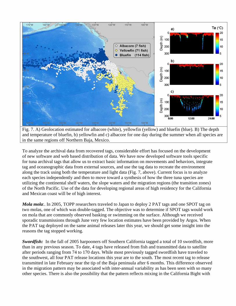
Fig. 7. A) Geolocation estimated for albacore (white), yellowfin (yellow) and bluefin (blue). B) The depth and temperature of bluefin, b) yellowfin and c) albacore for one day during the summer when all species are in the same regions off Northern Baja, Mexico.
To analyze the archival data from recovered tags, considerable effort has focused on the development of new software and web based distribution of data. We have now developed software tools specific for tuna archival tags that allow us to extract basic information on movements and behaviors, integrate tag and oceanographic data from external sources, and use the tag data to recreate the environment along the track using both the temperature and light data (Fig. 7, above). Current focus is to analyze each species independently and then to move toward a synthesis of how the three tuna species are utilizing the continental shelf waters, the slope waters and the migration regions (the transition zones) of the North Pacific. Use of the data for developing regional areas of high residency for the California and Mexican coast will be of high interest. Mola mola:. In 2005, TOPP researchers traveled to Japan to deploy 2 PAT tags and one SPOT tag on two molas, one of which was double-tagged. The objective was to determine if SPOT tags would work on mola that are commonly observed basking or swimming on the surface. Although we received sporadic transmissions through June very few location estimates have been provided by Argos. When the PAT tag deployed on the same animal releases later this year, we should get some insight into the reasons the tag stopped working. Swordfish: In the fall of 2005 harpooners off Southern California tagged a total of 10 swordfish, more than in any previous season. To date, 4 tags have released from fish and transmitted data to satellite after periods ranging from 74 to 170 days. While most previously tagged swordfish have traveled to the southwest, all four PAT release locations this year are to the south. The most recent tag to release transmitted in late February near the tip of the Baja peninsula after 6 months. This difference observed in the migration pattern may be associated with inter-annual variability as has been seen with so many other species. There is also the possibility that the pattern reflects mixing in the California Bight with
fish coming from the Central Pacific as well as Mexico and Central America. Interestingly the swordfish that travel south do not dive as deep as those that go farther offshore. This may be associated with shifts in the deep scattering layer as well as the shallower oxygen minimum zone off California and Mexico. One additional tag is scheduled to pop-up on September 1st. Four tags did not reported to satellite on their programmed date.
Sharks: The TOPP shark team is documenting the movement and behavior of 5 species of oceanic sharks migrating in the California Current. The sharks were selected because they are important predators, prefer a range of prey items from fish to pinnipeds, and cover diverse habitats. Four species, the white, thresher, mako and salmon sharks are all endothermic to varying degrees and capable of elevating body temperature above water temperature. The fifth shark species is the blue shark a more temperate species that is an ectothermic shark. Movements and behaviors are being examined using primarily PAT and SPOT tags. The SPOT tags provide accurate near real-time tracks while the PAT tags store data that is later downloaded to satellite. TOPP has pioneered the use of real-time shark tags and on two species (salmon and blue shark) we have succeeded in applying SDRL tags that provide live uplinks of dive behavior, speed, and oceanographic profiles. PAT: Over the last year, a total of (68) pop-up satellite archival (PAT) tags were deployed on blue, mako, salmon and white sharks. To date more than 70% of the tags deployed on all species have reported and tag performance in general has been excellent. The fast responding thermistor now allows for more accurate measurement of the water column profile and sea surface temperature (SST), which will improve SST-based latitude estimates. Over 5,000 temperature and depth profiles have been gathered in the North Pacific from shark data sets. SPOT: During the past year a total of (49) SPOT (Satellite Position Only Tags or Temperature Transmitting) tags were deployed on blue (15), mako (9), and salmon sharks (25). The salmon sharks provide the largest and most reliable platform for SPOT tagging and to date, have carried spots for as long as 2.7 years while still transmitting accurate data. This has provided unprecedented tracks, allowing for repeat migrations of individuals from Prince William Sound, Alaska to the tropics over consecutive years. The SPOT tags applied to blue and mako sharks provided tracks of two to 1.9 year durations. One of 9 tags deployed on mako sharks in 2005, and sixteen of the 25 tags deployed on salmon sharks were still transmitting after nearly one year. We continue to receive transmissions from 1 tag deployed in 2003 and 8 tags deployed in 2004 on salmon sharks. SPOT tags have provided a significant amount of data for both the salmon and mako sharks. Blue sharks have been on average smaller when tagged and the tags have provided significant data in the first few months but have been less reliable over the long run. White Sharks: Over the past year the white shark team has placed 30 PAT tags on 29 adult white sharks 2006 at Año Nuevo State Park and Farallones National Marine Sanctuary. One individual was tagged with two PAT tags, one tag being programmed for long-term deployment and a second tag programmed for a short-term deployment, set for high-resolution sampling. To date, 7 tags have release including the high-resolution tag previously mentioned. One tag the released prematurely after only 6 weeks, the remaining six all surfaced in the mid pacific area, half way between California and Hawaii, an area increasingly being identified as potential hot spot region for white sharks. Analysis of the data from this short-term tag high-resolution tag is providing much insight into the shark’s behavior. Analysis of the maximum and minimum daily temperatures and maximum depth for the animal shows the departure from the continental shelf in a clear and typical manner around February

14th and the subsequent travel on a three-week trip due west. The shark then spent the next 2 months west of 135 longitude with the PAT tag releasing at the end of April. During the coastal period, most of this shark’s time was spent between temperatures of 10°C and 14°C, with the animal experiencing rapidly increasing temperatures as it moved offshore. Upon leaving this region some portion of the shark’s time was spent in cooler water (6-8°C) at depth. Further analysis of time at depth indicates that during the coastal period, depths of 10-50m were largely favored. However, the shark was mostly at the surface during the crossing. Once in the hot spot region, the shark spent a significant amount of time in the 50-100m and 300-500m depth ranges. TOPP is hopeful that the second PAT tag deployed on this shark will report on schedule (August 7, 2006) and provide more information related to this animal. To date we have tagged a total of 69 white sharks, 59 of these were adults tagged in Northern California.
One pop-up tag was recovered and returned to the researchers, providing an archival record for the first 5 months of the deployment (Fig. 8, below). This shark moved from the west coast all the way to Hawaii where the battery died. It was ultimately found on a central California beach indicating the shark returned to the area in which it was tagged. After leaving the coast, the shark moved relatively rapidly to Hawaii making the nearly 2000 Nm trip in less than 40 days.
Preparations are currently underway to increase the use of acoustic tags, and to that end sub-surface monitors are being prepared for deployment at Ano Nuevo, Farallones Islands, and Point Reyes headlands. Dr. Peter Klimley and his team initiated an acoustic-tracking program off Point Reyes, California using an acoustic array to better detail behaviors near-shore around the rookeries where the sharks feed on a steady diet of pinnipeds. The 2005 field season off Pt. Reyes National Seashore was conducted from November 18th through December11th. During this period, there were a total of 10 sighting events with seven distinct sightings. On December 10th, a 5m female was tagged with an acoustic transmitter just behind the dorsal fin. This transmitter will provide data on location as well as the depth and temperature of the water when the shark is near Pt. Reyes.
Squid: One of the most elusive and least studied members of the TOPP species group is the Humboldt squid. This species is of particular interest given its role as both predator and prey in the California Current ecosystem. Efforts to collect information on Humboldt squid thus far have centered on developing and testing tagging methods. Previous work by the team has shown the pop-up satellite archival tags to be the most promising technology. Studies in the last year on Humboldt squid have utilized PAT tags with a focus on vertical movements in relation to the Oxygen Minimum Layer (OML), which begins at relatively shallow depths of 200-250m in the Sea of Cortez, Mexico. Three short-term tag deployments (3 days) were made in mid-November 2005, at the end of the commercial fishing season in Santa Rosalia. Two squid showed the expected pattern (based on our previous tagging efforts in early November of 2004), in which they spent nearly all of daytime hours at depths

associated with the OML (>200m) and most of the nighttime at depths of <150m. The third squid essentially remained at a depth of about 300m all day and night, with few excursions to shallower depths. This latter pattern had never been seen before and indicates that the squid can tolerate significant hypoxia (5% surface oxygen concentration at 300m) for a period much longer than previously observed. Furthermore, a surprisingly high level of locomotor performance was possible under these conditions. All three squid migrated northwest towards the San Pedro Martir basin during the three days they were tagged and covered distances of up to 70 miles. These data provide thus provide an estimate of swimming speed during a long-distance migration. They also suggest that some squid may either migrate to the San Pedro Martir basin itself, or that this basin lies on the route to the winter fishing grounds off Guaymas, an area thought to be the destination for the majority of squid migrating from Santa Rosalia at this time of year. In May 2006, another short-term pop-up deployment (5 days) was made near Santa Rosalia at the beginning of the commercial fishing season. This squid behaved in way that we have never seen. During both daytime and nighttime the squid spent the vast majority of its time at depths <150m. Only 25% of the time was spent deeper than 200m, all during the daytime, and the squid thus spent relatively little time in the OML. Although these data are preliminary, they suggest that large seasonal differences may exist in which the way Humboldt squid exploit the OML. Fieldwork planned for July and December 2006 will further examine this idea.
Leatherback Sea Turtles: During the past year, the TOPP turtle working group tracked leatherback sea turtles tagged at three different locations Jamursba-Medi (West Irian Jaya-Indonesia), Monterey Bay, California and Costa Rica. Working with a team of villagers at Jamursba-Medi, researchers deployed transmitters on 11 nesting female leatherbacks (8 SMRUs, and 3 WC SDRs) in July, 2005. This region, while very remote and nearly inaccessible, is the primary nesting area for leatherbacks in the Western Pacific. Leatherbacks tagged on Jamursba Medi, Indonesia are displaying tremendous diversity in their migration routes and foraging destinations. One turtle is located in the middle of the tropical Pacific, heading eastward, while another appears to be foraging in temperate waters of the North Pacific transition zone. Three individuals are approaching the West Coast of North America, where there are important foraging areas. One of these three leatherbacks is within 100 miles of San Francisco, nearly completing a trans-Pacific migration of over 13,500 km. This migration is one of the longest ever recorded for an aquatic vertebrate. The remaining active transmitter from Jamursba Medi is on a leatherback that has remained in a small area off the coast of Malaysia in the South China Sea for several months. Returning July 2006 to Jamursba-Medi, researchers were the opportunity to deploy an additional eight transmitters on 11 nesting female leatherbacks. A second tagging effort was conducted in September 2005 on the North Pacific foraging grounds of the turtles nesting in the Western Pacific. Researchers utilized spotter pilots to find leatherbacks off the San Mateo County coast. Free-swimming turtles were captured in the water using a specialized vessel and hoop net. A total of 9 turtles were captured and transmitters were deployed on 5. In the course of this work, one turtle was recaptured that was tagged and tracked in 2001. As in previous years, all turtles headed southwest along the same general trajectory other tagged leatherback sea turtles have taken in previous years, moved to a similar location just southeast of Hawaii before returning towards the northeast. Seven of the 11 leatherbacks tagged in Jamursba-Medi are still transmitting. One of the animals moved towards the northwest while all others have made relatively directed movements towards the northeast traveling a considerable distance with some likely on their way to the Monterey Bay.

In addition to the leatherbacks tagged in Indonesia and Central California, TOPP turtle working group continued to track turtles tagged in early 2005 in Costa Rica. These turtles forage in the southern hemisphere, in comparison to the Western Pacific turtles that forage in the northern Hemisphere. Nearly all of the SMRU (n=25) and SPOT tagged (n=10) turtles tagged at Playa Grande during 2004-2005, migrated southwest along the Cocos Ridge towards the Galapagos Islands before fanning out into the eastern south Pacific. A few turtles passed near Easter Island, converging with other turtles over a year later in offshore waters near the Central Chile. Of the eight tags deployed on leatherbacks over a year ago in Playa Grande, Costa Rica, One of the females tagged during 2005 remained along the inshore areas of Central America, and is currently situated near the coast of Pinas Bay, Panama.This turtle has remained within the bays and gulfs of Costa Rica and Panama, engaging in predominantly shallow dives throughout the tracking duration.
Loggerhead Sea Turtles: In 2005, the sea turtle working group added a second species to its tagging list, the loggerhead sea turtle, which is in even greater danger of extinction than leatherback sea turtles and more information on movements and behaviors is desperately needed. In September 2005, four loggerhead sea turtles were tagged on their nesting beaches in Mexico). During the year, three of these animals have remained relatively close to the tagging location, within a few miles of each other in the productive waters just to the north of Magdalena Bay, Baja, Mexico. One turtle has moved directly west towards Hawaii after spending some time off Magdalena Bay. TOPP Hotspot Workshop and SSC meeting: In late 2005, TOPP convened an international workshop on Biological Hot Spots at Hopkins Marine Station, in conjunction with the TOPP SSC meeting. More than 70 scientists from eight nations participated, with expertise in biologging science, physical and biological oceanography, remote sensing, and ecological modeling. The objectives were to determine how to better define and identify hot spots, which constitute essential habitat for top marine predators, and to classify these features by ecological function and level of biodiversity.
2. SOCIETAL BENEFITS, IMPACT & APPLICATIONS
∑ IMPACT AND APPLICATIONS
∑ Ocean Observing Systems
Bio-logging science is an emerging field that bridges electronic tagging, biology, oceanography and computer science. Advances in microprocessor-driven electronic tags have advanced our ability to collect information on marine animals on an ecosystem scale. The TOPP team is equipping animals with satellite and archival tags that provide data on the location of the animals and the oceanic environment through which they travel. These newly developed electronic tagging techniques are providing the means to elucidate the structure and function of open-ocean ecosystems from the viewpoint of the top predators. In addition, the data collected by animals are contributing to our ability to observe the circulation and physical patterns in the ocean on a global scale. Animal-collected oceanographic data have a nearly untapped potential to contribute to the developing global ocean observing system. The TOPP team has taken the first steps to integrate across disciplines, combining the animal collected data with oceanographic data sources. Such information will provide needed data for poorly sampled regions that can then be used for developing and testing models. Sub-surface

sampling has particular value, as these data are the scarcest yet are critical for models of ocean-atmospheric coupling and global heat balance.
∑ Marine Ecosystem-based Resource Management
The major output of TOPP will be the ability examine or model the movements of pelagic predators leading to a greater understanding of the North Pacific ecosystems. Ultimately, TOPP will show us where marine mammals, tunas, seabirds, turtles and sharks go to feed and breed. Moreover, TOPP will examine how the physical dynamics of North Pacific influence the distribution and abundance of predators from a variety of trophic levels. The results should provide information on how animals at different levels of the food web are coupled to oceanic processes, where bottom-up effects enhance primary productivity. In essence, the results will provide information on the key physical and biological processes involved in open-ocean ecosystem dynamics. The data will be extremely important for fisheries management plans for the U.S. and Mexican EEZ.
The acquisition of data on 22 species over multiple years will provide the necessary foundation of information for developing predictive models of marine predator movements in relation to environmental conditions. This level of understanding is required for dynamic, adaptive fisheries management and provides the information needed to conserve and manage marine resources.
3. WORK PLANNED FOR 2007
Efforts to identify hot spots will continue along a number of fronts including tag deployments and data analysis. Data analyses are proceeding on all individual species data sets including a general description of the movements, behaviors, and regional environment. Additional efforts are focusing on A) multi-species comparisons, B) describing and examining mini-hot spots, and C) how these hotspots are utilized by TOPP species. These analyses are on going. Pinnipeds: Post migration tag recoveries are planned for elephant seals. This includes recovery of new Mk10 TDRs with enhanced swim velocity measurements. More GPS and CTD tag deployments are also planned for seals at Año Nuevo. Tracking efforts are scheduled to resume again on San Nicolas and San Miguel Islands in late fall of 2006. This season, sea lions will also be equipped with new GPS tags that provide more locations per day with a greater accuracy. These tags not only allow us to precisely position animals on oceanographic or bathymetric features, but they will provide oceanographers with more accurate locations for the environmental data collected by the tags. The deployment of GPS tags on male sea lions in Monterey Bay in fall 2005 represented the first tests of this technology on California sea lions. Finally, more tag deployments are planned for sea lions at Granito Island in Mexico. Cetaceans: The 2006 cetacean satellite tagging field efforts will be directed at blue whales. This year will be a confirmation of a hypothesis developed after the 1997 El Niño for whales tracked in 1998. If blue whales are affected by low ocean productivity, we expect to see some whales emaciated and many concentrating their activities farther to the south (southern California Bight and northern Baja), where the poor krill conditions did not develop so much last year. Whales tagged in the area where conditions for krill are poor may seek offshore feeding areas more often and migrate to wintering areas less likely to be associated with calving (like the Sea of Cortez), if such segregation of winter habitats really

exists. If funded, attempts to re-sight tagged blue whales in the Sea of Cortez may be attempted in association with proposed work there on sperm whales. Seabirds: In addition to more in-depth data analyses, TOPP seabird researchers are planning a fifth consecutive season of tracking at Tern and Guadalupe Islands. This work will take place during December through March or April and will involve archival tag recovery and further deployment of satellite tags. We also hope to acquire more GPS tags that can be simultaneously deployed with archival temperature tags (i.e. Lotek LTD) to obtain highly accurate SST measurements. We may also explore the possibility of expanding our tagging efforts at Midway Atoll during the breeding season. Until our fledgling study, no other tracking studies on albatrosses had been conducted at Midway. Interestingly, Midway Atoll has the largest breeding colonies for both species of North Pacific albatross (~450k nesting pairs). Tag recoveries on shearwaters are also planned for October/November 2006 in New Zealand and in February 2007 in Chile. Depending on funding levels, more tags will be deployed to study the interannual migration patterns of both shearwater species. Fish: Over the course of the 2006, 200 Lotek archival tags on bluefin, yellowfin and albacore tuna. In July 2006 tagging took place for yellowfin and albacore tunas. 75 new tags were placed in fish off Baja. In October of 2006, researchers from the IATTC will go on a tagging cruise off the coast of the Baja Peninsula, Mexico to tag 60 additional yellowfin tuna, similar to deployments in 2003, 2004 and 2005. To tag additional bluefin tuna, we are planning a third trip to the tuna pens in Baja Mexico in the winter to deploy up to 75 archival tags. Deploying tags from the pens provides a reliable source of bluefin and allows us to release fish when fishing pressure is lower to minimize the short-term recoveries. Pacific bluefin tuna are being tagged in a pilot project off New Zealand where giant tunas of 200 kg in size have been recently discovered. If the pilot project is successful increased tagging will occur in this area in 2007. Efforts will continue in the analysis of data on all tuna species and creation of a browser based archival server of data that is nearing completion. This will form the basis of data delivery to OBIS and to our partnership developing at JPL NASA. Deployments are also planned for Mola mola and swordfish. In September and October of 2006 we plan to deploy a total of 10 PAT tags on Mola mola off both San Diego and in Monterey Bay. In the spring of 2006, we will return to Japan and deploy additional PAT and SPLASH tags on Mola mola. The SPLASH tags will be positioned higher on the fin of the mola than the previous SPOT tag in an effort to improve transmission number and quality. By utilizing the SPLASH tag, we will to obtain near real-time depth and location data. We are also collaborating with Japanese scientists who will survey the gelatinous zooplankton in the water column where the mola are diving. An additional 12 PAT tags will be deployed on swordfish from August through December, 2006. Sharks: A number of tag deployments are planned for the TOPP shark species over the next 12 months. PAT and SPOT tags (30 of each tag type) will also be deployed on salmon sharks in Alaska in August 2006. For the first time, archival tags, Lotek 2310 and Wildlife MK-9s (20 of each tag type) will also be deployed on salmon sharks during the Alaska trip. The salmon shark tagging will be the fifth year for these deployments, providing the opportunity to examine annual differences in movements and behaviors. Ocean observation analyses indicate that the Salmon sharks are taking high quality profiles and 2006 data as well as prior years will be assimilated in to the Alaska Ocean observation model via collaborations with JPL. For the second consecutive year, Mexican colleagues led by Oscar Sosa will go to sea aboard a Mexican longliner to deploy tags on blue and mako sharks. These cruises will allow for tagging of

these species over a broad geographic range and at different times of year to examine spatial and seasonal patterns. The goal is to deploy a total of 25 PAT and 25 SPOT tags on both species. For white sharks, we plan to deploy 30 PAT tags during the fall of 2006-winter 2007. In addition to the PAT tags, an acoustic array will be established near the rookeries to obtain more detailed information on the habits of white sharks while feeding at the pinniped colonies off central California. Squid: Research with squid will continue along several fronts. Over the next two years Dr. Gilly plans to deploy a total of 30 additional PAT tags on squid off the Pacific Coast of Mexico and in the Sea of Cortez to examine large-scale movements and behaviors. Complimentary efforts will focus on small-scale habitat use and how squid movement and behavior is influenced by the oxygen minimum zone. Using small-vessel acoustic telemetry, vertical movements of squid will be documented in relation to ambient oxygen levels. Respirometry studies will then examine the physiological impact of low oxygen levels and provide insight into the basis for observed behaviors. This effort will help us to better understand and predict how the environment influences the abundance and distribution of Humboldt squid in the California Current. Sea Turtles: A number of tag deployments are planned for the leatherback sea turtles over the next 12 months. We will continue to deploy Sea Mammal Research Unit (SMRU) satellite tags on leatherback sea turtles in various locations in the Pacific including Costa Rica and Monterey Bay. Recent efforts in Papua New Guinea, in July 2006, provided researchers with the opportunity to deploy eight tags on leatherbacks. The expansion of tag deployments at a combination of locations is allowing us to compare the behavior of turtles from multiple nesting sites and which forage in both the southern and northern hemispheres. Tagging efforts will begin along the California coast, north of San Francisco Bay, during September 2006. Along this coast it is possible to tag male sea turtles, which do not return to the nesting beaches and for which there is currently very little information. Satellite tagging efforts in Costa Rica will continue in January and February 2007, with leatherbacks being tagged at Playa Grande.
4. EDUCATION & OUTREACH
TOPP web efforts: During the year, the web team added eight new content features to the public web site, providing coverage of squid, sea bird, tuna, whale and shark tagging efforts. Each feature included one or more written stories, supplemented by multimedia components. The most elaborate of these was in the salmon shark feature, which included animated figures from the Science paper, narrated by Kevin Weng, the paper’s lead author. In August the web team also contracted Cignex, Inc. to begin development and construction of a Plone-based content management system to facilitate communication among TOPP participants. This new web site, called the “TOPP Network” launched in January, 2006 and has proven to be an invaluable tool for information sharing within the program at both working group and project-wide levels. Media relations: The TOPP program received national news coverage associated with the salmon shark paper in Science. AAAS decided to publish the paper side by side with another piece on white shark migrations by Ramón Bonfil et. al., and their own press release lumped both papers together. In 2006, our TOPP seabird researchers published a paper in the Proceedings of the National Academy of

Sciences USA on sooty shearwater migrations. The paper was covered in over 70 websites and papers, as well as four radio interviews. Informal education: The plan to share TOPP with aquarium visitors took a significant step forward when it was incorporated into the 2006 budget and planning process for the Monterey Bay Aquarium. TOPP will be incorporated into a remodeled “Vanishing Wildlife” exhibit, which surrounds the lower viewing window into the million-gallon Outer Bay exhibit. Planning for this will begin in November 2005, with the exhibit opening planned for Spring 2007. Education and Outreach: In January 2006 the TOPP web site received a Level 2 Ultraweb Award. Of the nearly 5,600 applicants in 2005, fewer than 100 achieved this level. In January we also launched the “TOPP Communication Network,” a plone-based web site designed to facilitate information sharing within TOPP. Visit the award winning website at: http://www.toppcensus.org/. The white shark animation on TOPP’s home page was recognized this spring by the judges of the Web Marketing Association's ninth annual Internet Advertising Competition (IAC) Awards as the best non-profit rich media online ad. The (IAC) Awards honor excellence in online advertising and recognize the individuals and organizations responsible for the best in Internet marketing. The IAC Awards are the first and only industry- based advertising award competition dedicated exclusively to online advertising. Other winners included Disney Online, Foote Cone & Belding, Walt Disney Parks and Resorts, America Online, Inc., and Ogilvy Worldwide. E&O accomplishments also include a new print piece. The team completed a TOPP 8-1/2 by 11 inch single fold, full color, glossy brochure designed by the Monterey Bay Aquarium’s print graphics team.
5. GEOGRAPHIC EXPANSION
The CTD tags developed under an ONR grant have enabled a number of international programs including SEAOS (Southern Elephant Seals as Oceanographers) and the International Polar Year program MEOP (Marine Mammals as Oceanographers Pole to Pole). These projects are using the CTD tag developed with NOPP support to further the use of marine animals as oceanographic sensors, which includes investigators from the USA, UK, Canada, Norway, Germany, South Africa, Australia, France and Brazil. The data on physical and biological oceanography collected under the auspices of TOPP will be made available to the regional and global oceanographic communities including NOAA Coast Watch program, GOOS (Global Ocean Observing System), CIMT (Center for Integrated Marine Technology), MBARI, ICON (Innovative Coastal-Ocean Observing Network), PISCO (Partnership for Interdisciplinary Studies of Coastal Oceans), SIMoN (Sanctuary Integrated Monitoring Network), MARS (Monterey Accelerated Research System) and AOSN (Autonomous Ocean Sampling Network). Additional oceanographic data, especially sub-surface, is critical to the expansion and improvement of oceanographic models including those coupling atmospheric and oceanic processes. The Navy relies extensively on these models to provide predictive forecasts to its operational fleet. Also, the development of technologies that allow researchers to determine oceanic “hotspots” for marine vertebrates will allow fleet planners to better evaluate whether Naval exercises will encounter specific marine animals. The TOPP concept has generated considerable interest outside the North

Pacific. At present there are four international efforts under development that employ an approach similar to TOPP. These are the Galapagos/ Cocos Ridge Seascape. Initiative, Novel Exploration of the Ocean (NEO), Southern Ocean TOPP and Deep Sea Look (DSL). TOPP expansion has also been occurring in the Pacific as more researchers have shown interest in the TOPP effort. To date, in 2006, scientists from TOPP have been at meetings in Chile, Japan and New Zealand where projects are being discussed that would allow tagging in all three locations. Pilot efforts in the Eastern Tropical Pacific with yellowfin tuna and sharks this year have shown the feasibility of developing collaborative links for tunas and shark species. If renewal with Moore is successful in 2007, we envision increased participation of TOPP from Japan, New Zealand and South and Latin American countries.
6. PARTNERSHIPS & COLLABORATION
a. Partnerships Organization Name Point-of-Contact Nature of Relationship Tag A Giant Barbara Block Sharing resources and technology National Undersea Research Program Dan Costa Sharing resources and technology Bird Life International John Croxall Provided data and expertise to world
albatross conservation Center for Integrated Marine Technology: From Wind to Whales
Gary Griggs Sharing resources and technology
Malpelo Foundation, Costa Rica Sandra Bessudo Sharing Tagging Technology Blue Water Fishing Inst., New Zealand John Holdsworth Sharing Tagging Technology Sea Mammal Research Unit Mike Fedak Sharing Tagging Technology University of Austral de Chile Carlos Bustmante Sharing Tagging Technology
b. Links to Other CoML Ocean Realm Projects Please identify other projects within CoML with which your project shares common themes, cruises of taxonomic expertise, other joint activities, including synthesis work. Identify any crossover personnel.
Project Name Cross-Over Person(s) Nature of Relationship OTN Ron O’Dor Advising FMAP Ram Myers Collaboration POST Heather Advising
c. Links to CoML National and Regional Implementation Committees (NRICs) Please identify CoML NRICS with which your project has collaborated or sought assistance with regards to global expansion. Identify any liaisons or crossover personnel.
NRIC Liaison or Cross-over personnel Nature of Relationship Australia John Gunn SSC Canada Ron O’Dor, Mike Stokesbury Advising OTN Caribbean

China Europe Mike Fedak Technology Indian Ocean Japan Nobuyuki Miyazake Providing assistance with TOPP-Like
Expansion South America Sub-Saharan Africa USA
d. Liaisons to CoML Cross-Cutting Groups Please identify the person within your project who is designated as the liaison to the following projects and committees.
Project Name Liaison Name & Institution Nature of the Relationship OBIS Glenn Strout TOPP Data Manager HMAP FMAP Ram Myers Transfer of Code and Programming SCOR Tech Panel John Gunn, Geoff Arnold Discussions of Technology E&O Randy Kochevar TOPP Education and Outreach Network
Liaison Barcoding