syntactic and semantic based approaches for geoinformation management - dr. surya s. dhurba
TRANSCRIPT

Syntactic and Semantic-based approaches for
Geoinformation Management
Surya S. Durbha, PhD Associate Professor
CSRE, IITB

Outline
Background
Standards-based Geospatial Approaches
Sensor Web enablement of GeoSensors
Need for Semantic approaches for integrating
Geoinformation

Earth Observation from Multiple Vantage Points
Multiple vantage points for
Earth observation leads to
widespread real time sensors
and multiple archives of
imagery and other datasets.

Keywords
Geographical Information Systems Spatial
Data, Vector, Raster
Standards, information sharing
OGC, Web Services, Interoperability
Data Integration, Decision Support
Geoinformatics,
Information
Systems,
Computer
Science,
Remote
Sensing

Overview and Definition of GIS
It brings together the ideas developed in various fields
Focus of GIS activity centers around
Hardware and software
Information processing
Applications

Environmental Attributes Map Layer
Geology
Hazard Areas
Existing Land Use
Noise Contours
Floodplain
Soils
Vegetation
Surficial Hydrology
EI Study Areas
Planning Study Index Reference

Spatial Data Layers
Landuse
Location
Soil
LandCapability
Roads
VillagesBnd

What Does A GIS Do? GIS can answer the following questions:
1. Location - What is at a given location?
2. Condition - Where does it occur?
3. Routing - What is the best way?
4. Trend - What has changed?
5. Pattern - What is the pattern?
6. Modeling - What happens if ?

Who needs access to coordinated geographic
information?
Land Records Adjudication
Disaster Response
Transportation Management
Water, gas & electric planning
Public Protection
Defense
Natural Resource Management
Telecommunications
Infrastructure
Economic Development
Civic Entrepreneurs
Regional Stewards

Standards based Geospatial
approaches

11
Client1 Client2 Client3
Server1 Server2 Server3
Client1
Server1 Server2 Server3
Client2
Non-interoperable Systems
Connected Systems
Geospatial Interoperability
Geospatial Interoperability enables disparate and geographically distributed systems/information sources to use and exchange geospatial information
Standards-driven geospatial web services provide interoperability and the ability to harmonize varied data sources.
Interoperability enables to build cost effective systems, and helps to reduce redundancy in an organizations spatial infrastructure.
Geospatial Web services is the de facto way to access and publish:
Data, Services and metadata
Spatial Data Infrastructures (SDI) are adopting these standards to facilitate interoperability with other SDI systems world wide.

Understanding the context for information
discovery
Need information about
roads that are NOT flooded
for rapid evacuation
Web service
that provides
data about
traffic and road
condition based
on several
parameters
Context 1 Context 2
Disaster
Management
…Context N

13
Vision:
Develops standards
for geospatial web
services
Mission:
A world in which
everyone benefits
from geographic
information and
services made
available across any
network, application,
or platform
The Open Geospatial Consortium (OGC)
Need to integrate Geospatial data
from heterogeneous data sources.
Incompatibilities in structural,
syntactical and semantic
representation hinders interoperability.
Lack of interoperability impedes
development of integrated decision
support systems, reduces the ability to
respond to time critical events and in
general provide the right information
at the right time.

Web Services

Services, Interfaces and Operations
Service - distinct part of
the functionality that is
provided by an entity
through interfaces,
Interface - named set of
operations that
characterize the
behavior of an entity
Operation -
transformation or query
that an object may be
called to execute. Each
operation has a name
and a list of parameters.
Service
Operatio
n
Interface provides
requires
ha
s
"A service is a function that is well-defined, self-contained, and does not
depend on the context or state of other services.”-Source: Web Services
and Service-Oriented Architecture: The Savvy Manager's guide

Web Services
A service registry is
a directory of
services available
in an SOA system.
It contains the
physical location of
services, versions
and validity periods
of services, service
documentation,
and policies.
A service registry
is one of the main
building blocks of
an SOA
architecture.

SOA and XML
SOA needs a common platform to base its
infrastructure.
XML is the foundation for virtually all web services
standards, such as:
XML schema, SOAP, Web Services Description Language
(WSDL), and Universal Description, Discovery, and
Integration (UDDI).
XML resolves the challenge of working with different
data formats in different applications across multiple
platforms.
XML has the benefit of ease of representation, being
text-based, flexible, and extensible by nature.

Representational State Transfer(REST)
o REST Web service follows four
basic design principles:
• Use HTTP methods explicitly.
• Be stateless.
• Expose directory structure-like
URIs.
• Transfer XML, JavaScript Object
Notation (JSON), or both.
The acronym REST stands
for Representational State
Transfer, this basically means
that each unique URL is a
representation of some
object.
In RESTful web services, the
emphasis is on simple point-
to-point communication over
HTTP using XML
You can get the contents of
that object using an HTTP
GET, to delete it, you then
might use a POST, PUT, or
DELETE to modify the object

GET/POST operations (REST)
GET is a read-only
operation. It can be
repeated without
affecting the state of the
resource and can be
cached
POST is a read-write
operation and may
change the state of the
resource and provoke
side effects on the server.
To create a resource on the
server, use POST.
To retrieve a resource, use
GET.
To change the state of a
resource or to update it, use
PUT.
To remove or delete a
resource, use DELETE.

Copyright (c) 2009 Opengeospatial
Consortium
OGC Web Services (OWS)
Web Map Service (WMS)
Web Feature Service (WFS)
Web Coverage Service (WCS)
Catalogue (CSW)
Geography Markup Language (GML)
OGC KML
Others…
Relevant to geospatial information applications: Critical Infrastructure, Emergency
Management, Weather, Climate, Homeland Security, Defense & Intelligence, Oceans
Science, others
Web Map
Server
Web Coverage
Server Web Feature
Server
George Percival, OGC Standards: an Overview Tutorial,2010


OGC Web Services
Copyright © 2010, Open Geospatial
Consortium, Inc.
What
can you
do? GetCapabilities Here…
read this.
<Service>
…
</Service>
<Capabilitiess>
…
</Capabilitie>
<Layer>
…
</Layer>
Capabilities Document
Great!
Give me
data
Get Map, Feature, or Coverage
Data Here you
are….
George Percival, OGC Standards: an Overview Tutorial,2010

23
1. Data Discovery: Provide search and discovery to geospatial data and services
1. Data Visualization – Provide visualization images of the actual geospatial data
1. Data Access – Provides access to the actual geospatial data
Web based services with a focus on geospatial information
Geospatial Web Services

24
User
Applications
Data
Discovery
Catalog Catalog Catalogs
Geospatial
Web Services
Features Content
Repositories Coverages
Data
Visualization
Data
Access
Geospatial Web Services Types

Web Map Server
Web Coverage Server
Web Feature Server
With OGC web services, an analyst or operator can
dynamically access that data which is relevant to the task
at hand, directly from the authoritative data steward, using
a variety of tools.

Multiple overlaid
maps
One GetMap request:
Borders Elevation Cloud Cover
Cities
Web Map Service (WMS) can get
multiple maps

Standards based Web Services
Applications e.g., Community Water Quality,
Climate Change Monitoring,
Site Assessment
Services e.g., Water Quality Index Service
Gazetteer service,
Web Map Service
Data e.g., water quality, quantity,
topographic,
thematic, imagery,
toponymy, metadata
Users
Other
Applications
For Example… A community website
which calculates
water quality for a
given community
Uses Gazetteer service,
Water Quality Index
Service
Web Map Service
based on
Geographical Names,
Road network features
Base maps


http://www.sensorsmag.com/files/sensor/nodes/2007/1437/Figure4.jpg

Many Application Areas
http://elca1.inaoep.mx/~jescami/images/IoT.jpg

http://2.bp.blogspot.com/-
sDQw7QOfEnU/VEvOpzbnL5I/AAAAAAAAALE/ytwoKlz0wX0/
s1600/Smart%2BCities.jpg

IOT Smart City
http://www.satiztpm.it/wp-content/uploads/2014/02/Smart-city.jpg

The problem
CSIRO. WaterML2.0 overview
Need flow data! I’ll ring Don, he Has Data
*RING RING*
Hi Don, I need some
upper Derwent flow
readings for my
geochemical model.
Any ideas?
Don
Hmm, I’ve got one site.
I’ll send it through…
10 minutes…
To: Jack
01/02/09, 3.2, 3, 1
01/02/09, 3.1, 3, 1
10 minutes… *RING RING*
Ok. Got the data.
Where is the site
located?
Oh, it’s at laughing jack bridge.
Coordinates? Ummm. (papers shuffle)
147.123 -41.588
What reference
system?? I think it’s GDA94
Ok. What sensor is
used?
It’s calculated from the stream
gauge reading using a rating
curve.. Oh…how accurate is
that? Umm......
DON?
Hydro Jack
*CLICK*

© 2007, Open Geospatial Consortium Interoperability Institute, Inc.
41
Sensor Webs
Webcam
Environmental
Monitor
Industrial Process Monitor
Stored
Sensor
Data
Traffic
Monitoring
Satellite-borne Imaging Device
Airborne
Imaging
Device
Health
Monitor
Strain
Gauge
Temp
Sensor
– Sensors connected to and discoverable on the Web
– Sensors have position & generate observations
– Sensor descriptions available
– Services to task and access sensors
– Local, regional, national scalability
Automobile
As Sensor Probe


Sensor Web Vision I
Sensors will be web accessible
Sensors and sensor data will be discoverable
Sensors will be self-describing to humans and
software (using a standard encoding)
Most sensor observations will be easily
accessible in real time over the web

Sensor Web Vision II
Standardized web services will exist for
accessing sensor information and sensor
observations
Sensor systems will be capable of real-time
mining of observations to find phenomena of
immediate interest
Sensor systems will be capable of issuing
alerts based on observations, as well as be
able to respond to alerts issued by other
sensors

Sensor Web Vision III
Software will be capable of on-demand
geolocation and processing of observations
from a newly-discovered sensor without a priori
knowledge of that sensor system
Sensors, simulations, and models will be
capable of being configured and tasked through
standard, common web interfaces
Sensors and sensor networks will be able to act
on their own (i.e. be autonomous)

Building Blocks: OGC SWE
Registries & Dictionaries
Sensor
Description Language
Phenomenon
Description Language
Services
Observation Tasking Alerting Analysis
SensorML O&M
SOS SPS SAS WNS
CS-W

Source: crisisgrid.org

Forest Fire Monitoring
Jirka, S., Broring, A., Stasch, C.: Applying OGC Sensor Web Enablement to Risk Monitoring ¨ and Disaster Management. In: GSDI 11 World Conference, Rotterdam, Netherlands (June 2009)

Flood Monitoring and Prediction
Source: Nataliia Kussul, Andrii Shelestov, Sergii Skaku
THE SENSOR WEB TESTBED FOR FLOOD MONITORING AND PREDICTION

Water Quality Monitoring
Jirka, S., Broring, A., Stasch, C.: Applying OGC Sensor Web Enablement to Risk Monitoring ¨ and Disaster Management. In: GSDI 11 World Conference, Rotterdam, Netherlands (June 2009)


IMpacting Research, INnovation and
Technology’ (IMPRINT-India)

IMpacting Research, INnovation and
Technology’ (IMPRINT-India)

IMpacting Research, INnovation and
Technology’ (IMPRINT-India)

Discovery and access mechanisms for sensors and data within and
across wireless sensor networks (WSNs)_
Development of standardized catalogue or sensors registry, for
querying services, individual sensors, and spatio-temporal data.
Ability to retrieve the lineage of sensor observations (Data
provenance)
Automatic sensor installation, configuration and operation (GC)
Integrating diverse sensors into observation systems
Integrating data from sensor networks into the National Spatial
Data Infrastructure (NSDI)
Event based-notification and alerts
Ability to support on-demand processing of sensor observations
accessed from disparate and sensor networks belonging to multiple
domains (e.g. Water and environment)
Development of remotely taskable sensor systems (GC)
IMpacting Research, INnovation and
Technology’ (IMPRINT-India)


Geosemantic Web

Semantic Interoperability
“Although standards from bodies like the OGC
provide the basis for syntactic interoperability the
usability of information that is created in one
context is often of limited use in another context
because of insufficient means for meaningful
interpretation”
(Bernard, Einspanier, Haubrock, et al., 2003),

Image search: Tiger

Semantic Web
Semantic means meaning
Meaning enables a more effective use of the underlying
data. Meaning is often absent from most information
sources, requires users or complex programming
instructions to supply it.
Semantics give a keyword symbol useful meaning
through the establishment of relationships. ( e.g.
Building, Bank, etc)

Joshua Lieberman - European Geoinformatics Workshop 2007 ©Traverse Technologies.
Which airfields within 80
miles of Banda Aceh support
C5A aircraft, i.e. have a
runway length >= 12000 ft?
equivalence or
subsumption
based on
based on Domain
Ontology
Ontological (DL) description of
the query concept
Query concept
ID Name Airp_Ident ICAO Elev Type
1 Greenville US01357 KZ 00541 A
2 Festus Mem US05536 KZ 00433 A
Ontological (DL) description of the application concept “Dafif_Airport”
Application Ontology
Concept John Smith
Hybrid Ontology Approach
Logical
Reasoning
Ontologies for Enhanced GI Discovery

Joshua Lieberman - European Geoinformatics Workshop 2007 ©Traverse Technologies.
“Typical” Geospatial Query
(Intelligence / Logistics Domain)
“Which airfields within 500 miles of Kandahar support C5A aircraft?”
Aero Feature or
Geo Feature?
Buffer or
proximity?
Statutory or Nautical?
Straight-line or driving?
Coordinate system? Afghanistan?
Centroid or outline?
What does this
mean to a GIS ?
Feature
property or
non-spatial
information?

“Typical” Analyst Query:
“Which hospitals within 30 mins of Alpine, CA provide burn
treatment?”
Buffer or
proximity?
Driving or Flying?
Road Closures?
Where is this?
Centroid or outline?
Feature Reference
Type? What does
this mean?
Definition?

• We need to associate a number of factors, including hospital type and facilities – its accessibility after a disaster – and the staff available
• The query needs to be structured based on Concepts & Relationships that can be retrieved and then customized for the specific query.
• Using this approach, a listing of the hospitals capable of dealing with large number of burn cases is returned to the user and information associated with the query retrieved.
A “Simple” Knowledge Query Which hospitals within 30 mins of Alpine, CA
provide burn treatment?”

Semantic heterogeneities
Sea surface Temperature Ocean Temperature
GCMD (Global Change Master Directory)
Wind_Speed
DODS
Wind_Speed Wind_Speed_ve
(Vector averaged wind speed)
Wind_Speed_sc
(scalar averaged wind speed)
NDBC
Wind Speed Water Temperature

Example Ontology for Natural
Disasters
University of Georgia
Dept. of Computer Science

Example Ontology for Volcanoes
University of Georgia
Dept. of Computer Science

Semantic Conflicts
GoMoos buoy data served
through Distributed
Oceanographic Data System
(DODS)
NDBC

A concept called WaterTemperature

A-Box and T-Box
SPARQL A-Box Query
SPARQL is a protocol and query language for semantic web data sources.
Based on matching graph patterns.
PREFIX rdfs:<http://www.w3.org/2000/01/rdf-
scheme#>
PREFIX
bu:<http://cosem.erc.msstate.edu/ontologies/cosemo
nt.owl#>
SELECT *
FROM <file:/c:/ontologies/cosemont.owl>
WHERE
{
?s bu:hasStationID ?g.
?s bu:waterTemperature ?WaterTemperature.
?g bu:latitude ?la.
?g bu:longitude ?lo
FILTER(?WaterTemperature>20)
}

Example SPARQL Query (Scenario: “Find devices that can
produce certain output variables”)

Coastal Semantic Middleware


Heterogeneities in Classification Systems
The problem is finding the right data that matches a given criteria.
Classification systems exist in several domains and also unique to different countries.
Information is normally disseminated through classification
Land Cover
International Geosphere Biosphere Programme (IGBP)
United States Geological Survey (USGS)
Olson Global Ecosystems (OGE)
Simple Biosphere model (SiB)
Simple Biosphere 2 (SiB2)
Biosphere Atmosphere Transfer Scheme (BATS)
Soils natural resources conservation service
(NRCS)
Canadian soil classification system
Unified soil classification system
Wetlands U.S. Fish and wildlife service
USGS wet land classification
Ramsar classification system
Cowardian system

International Geosphere
Biosphere Programme (IGBP)
Simple Biosphere model (SiB)
Semantic conflicts between classification systems
(IGBP and SiB)
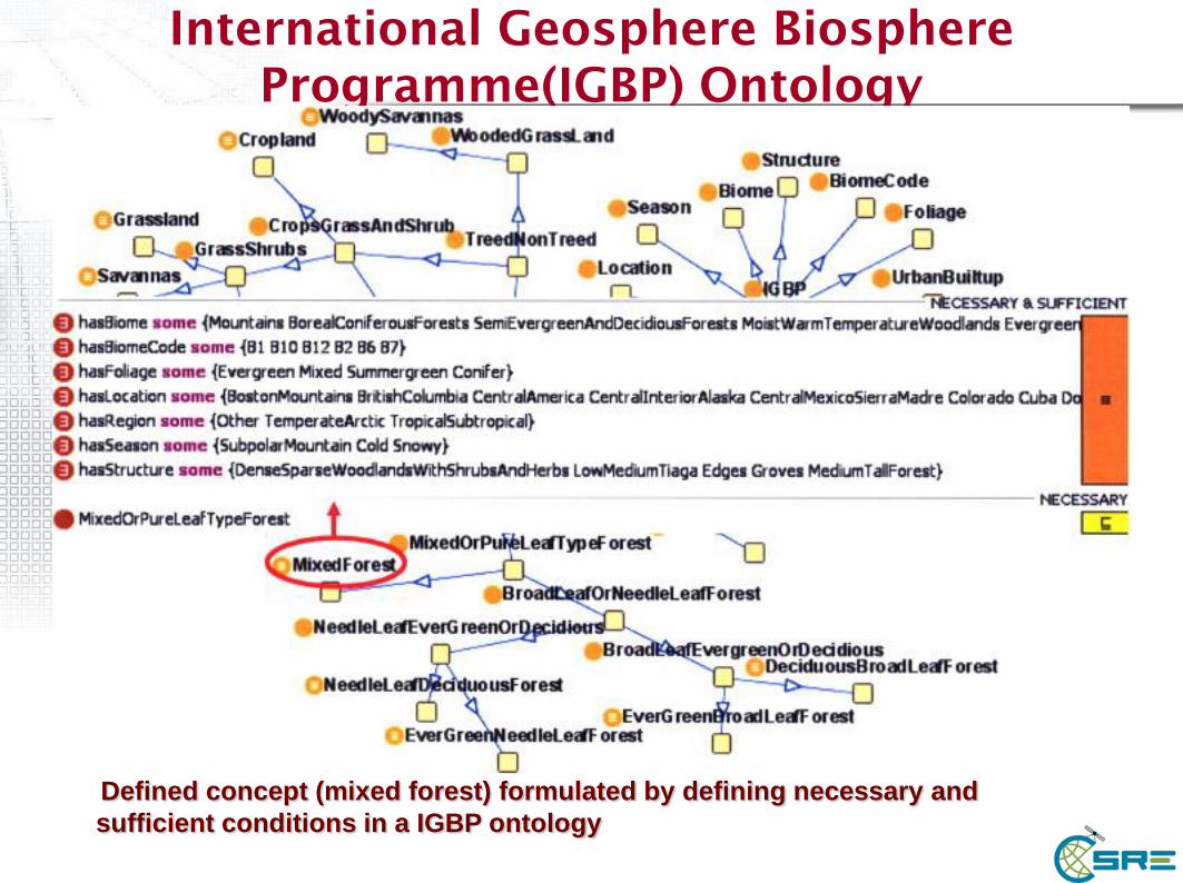
International Geosphere Biosphere
Programme(IGBP) Ontology
Defined concept (mixed forest) formulated by defining necessary and
sufficient conditions in a IGBP ontology

Thank you

Spatial Decision Support Systems
(SDSS)

Information Systems are of two types
Transaction processing systems
o Emphasis on recording, updating and retrieving as per the occurrence of operations
o Operate in on-line or batch mode and follows well defined procedures
Example : Banking and Airline Reservation Systems
Decision Support System
o Emphasis on manipulation, analysis and particularly modeling to support decision makers.
o Used in market analysis, resources planning, defence etc.
GIS belongs to the second type!

http://proceedings.esri.com/library/userconf/proc97/proc97/to500/pap486
/p4861.gif

81
Applications
Many Applications of network routing
Examples: Online Map service,
phone service, transportation
navigation service
Identification of frequent routes
Crime Analysis
Identification of congested routes
Network Planning

Spatial Decision Support
Many times decisions have to be taken by
administrators
o Cannot satisfy all stakeholders
o Cannot find money for entire needs
o Cannot complete the task within a given time
o Cannot protect environment while carrying
out development projects
Environment related issues are most
controversial, requiring most spatial
inputs

Use of GIS for
environmental/resources
management applications includes:
1. Data management
2. Data Assessment
3. Modelling and spatial analysis
4. Management and decision support
Applications 1 thru 3 culminate in 4...
the end use?
Spatial Decision Support

Application or decision support?
An application may end at any point
o Spatial / attribute data creation end at 1
o descriptive/mapping exercise may end at 2
o predictive modelling exercise may end at 3
o BUT they must start at 1 and work through
these stages in sequence
The ultimate end application must be
decision making (i.e. management) and
use in support of decisions made
Example:
Environmental Management
Aims of environmental management:
o to prevent environmental deterioration and
degradation
o to promote sustainable use of the environment
o to prevent over use or exploitation of natural
resources
o to preserve environmental diversity
Objectives of environmental management:
o to control the environment and/or our influences
upon the environment via direct or indirect action
o i.e. putting environmental science to work!

Decision making or support?
Decision making vs decision support
o GIS can provide certain tools for assisting
in the decision making process
i.e. maps/displays as means of visualising
the problem
overlays as means of defining relationships
modelling as means of predicting outcomes
etc.

…the answer
GIS functions on their own are NOT
decision making tools...
o (i.e. they only ASSIST in the decision making
process)
o ...therefore, GIS is not a decision making
tool, it is a decision SUPPORT tool

Decision making
Decision making:
o a decision is a choice between
alternatives to meet specific objectives
o the alternatives may represent:
different courses of action
different hypotheses
different use of a geographical entity etc.
Decision objectives
Objectives are governed by management goals
and in turn determine the range of alternatives
o e.g. identify areas of high risk in soil erosion
example in order to address the goal of preventing
soil erosion
o resulting alternatives may be different maps
representing different management plans
Process, governing the way decisions between
alternatives are made, is the “decision rule”

Applications of Local Operations
Soils:
Revised Universal Soil Loss Equation (RUSLE) uses six
environmental factors in the equation:
A=R K L S C P
A=average soil loss
R=rainfall-runoff erosivity factor
K=soil erodibility factor
L=slope length factor
S=slope steepness factor
C=crop management factor
P=support practice factor
Each factor can be prepared as as an input raster.
o Multiply the rasters in a local operation to produce the output
raster of average soil loss.
http://www.scotland.gov.uk/Resource/Img/47121/0020519.jpg

Definition of a DSS
In general terms, DSS are:
o computer-based systems
o dedicated to a restricted but well defined area of
application
o systems incorporating modelling and analysis with
data and database management systems
o systems which do not make decisions, but facilitate
logistics of decision making process
o interactive systems that help decision maker carry
out a decision research
o providers of custom-built information
o providers of user-friendly GUI with short response
times

Developing Spatial DSS
The role of GIS?
o GIS is an INCREDIBLY USEFUL tool
o SDSS retains the general characteristics of basic DSS but in addition
they include:
spatial data input capabilities
storage of complex structures common in spatial data
analytical techniques unique to spatial data
cartographic output
An agricultural SDSS might be comprised of:
o climatic and economic models
o GIS software
o spatial data

http://www.impetus.uni-koeln.de/uploads/pics/projekt_konzepte_dss_02.png

SDSS Components
SDBMS - locational, topological and thematic data types to
support cartographic display, spatial query, analytical
modeling
MBMS - model base management system to support
statistical and numerical models which stores models
instead of data
Each model may be a small piece of code to solve a part of
an algorithm

SDSS Components
Knowledge based reasoning, image processing may
be part of the MBMS
Graphical and tabular report generators
2-d and 3-d displays
Bar charts, pie-charts, scatter plots, line plots, ...
Application specific plots and reports


Credit: Environmental Simulation Center, 2004.
3D visualization is used to show community members how
a proposed development would change the landscape.