sydney private bus routessydneybusroutes.com/images/pdfs/rtehist reg 13.pdfpage 5 of 66 19 august...
TRANSCRIPT
Page 1 of 66 19 August 2019 Private Route Histories Region 13
SYDNEY PRIVATE BUS ROUTES
Brief histories from 1925 to the present of private bus services in the metropolitan area of Sydney, New South Wales, Australia
Route Histories – Contract Region 13
(South-west between Lidcombe, Granville, Bankstown & Liverpool)
Prior to 18 September 2006
Routes 405, 484-486, 499, 655, 817, 818, 857-863, 902-908, 910, 915-921, 930, 932 & 935-937
(and 486A)
As from 18 September 2006
Routes 900-916, 925, 950, 999, M90-92 & S1-4 (and 902X)
in the Sydney Region Route Number System
Overview
Suburbs in contract region
(Suburbs with railway stations in bold)
Auburn
Bankstown
Bankstown Aerodrome
Bass Hill
Berala
Birrong
Cabramatta
Carramar
Chester Hill
Chipping Norton
Chullora
Condell Park
East Hills
Fairfield
Georges Hall
Granville
Greenacre
Guildford
Hammondville
Harris Park
Holsworthy
Lansdowne
Lansvale
Leightonfield
Lidcombe
Milperra
Moorebank
Old Guildford
Padstow
Padstow Heights
Panania
Picnic Point
Pleasure Point
Regents Park
Revesby
Rosehill
Sandy Point
Sefton
South Granville
Villawood
Voyager Point
Wattle Grove
Yagoona
Some routes extend beyond the boundaries of the contract region to patronage generators such as Burwood,
Liverpool, Parramatta & Strathfield.
Operators
In 2004, when the contract regions were established, the incumbent operator in Region 13 was Veolia Transport, now
trading as Transdev.
After negotiations with the Government, Transdev retained the contract.
Includes routes in the same area prior to the creation of the contract regions in 2004.
A work in progress. Corrections and comments welcome – [email protected]
denotes this route or this version of the route no longer operative.
Page 2 of 66 19 August 2019 Private Route Histories Region 13
Regional review
Effective 18 September 2006 – complete Region 13. Also part of this review were Routes 922, 923, 924, 926 & 927,
which are part of Region 10, and 925 which was transferred from Region 10 to Region 13 at that time.
(See “Regional reviews by Ministry of Transport – 2006-10” under the “Major Changes” tab on the main menu.)
+ + + + + + + + +
(A) Route Histories prior to 18 September 2006
Route 405
PARRAMATTA – AUBURN – LIDCOMBE
Timeline 15 December 1986: Parramatta – Auburn renumbered from 168 [1925 number]. Operated by Auburn Bus Services
(Barry Briggs & Stephen Todd).
9 October 1989: Auburn Bus Services transferred to Ian Barden & Associates.
1990/1 (between May 1990 & March 1991): 59 [1925 number] & 405 amalgamated as 405, Parramatta – Auburn –
Lidcombe.
1 August 1990: Auburn Bus Services formed an association with Nowra Coaches & trading name changed to Auburn
Coaches.
21 September 1990: Transferred to E Street Bus Lines (Bob Taylor).
2 October 1990: Retransferred to Auburn Bus Services (different proprietor?).
Mid October 1990 (or 1 February 1991?): Transferred to Auburn Coaches (John King of Nowra Coaches & John
Cerezo).
February 1993: Transferred to Nowra Coaches (John King).
8 March 1993: Transferred to Baxter’s Bus Lines.
17 December 1995: Renumbered 904.
Streets
Parramatta – Auburn From 15 December 1986 From Parramatta (Darcy St at station) via Darcy St, Church St, Argyle St, Marsden St, George St, Smith St, Station
St, Parkes St, Wigram St, Una St (Harris Park), Harris St, Allen St, Good St, Cowper St, Rowell St, Bridge St
(Granville), Good St, Parramatta Rd, Melton St, Adderley St, Station Rd, Rawson St to Auburn station.
From Auburn (Rawson St at station) via Northumberland Rd, Simpson St, Station Rd, Parramatta Rd, Rowell St,
Bridge St (Granville), Good St, Allen St, Harris St, Una St (Harris Park), Wigram St, Parkes St, Station St, Darcy St
to Parramatta station.
Parramatta – Auburn – Lidcombe From 1990/1 (between May 1990 & March 1991):
Extended, ex Parramatta from Station Rd, Auburn via Hall St, Northumberland Rd, Rawson St, Dartbrook Rd,
Parramatta Rd, John St, Dewrang St, Nyrang St, Boorea St, Yarram St, John St, Church St to Lidcombe station.
Return via Station St, Swete St, Mary St, John St, Yarram St, then reverse route.
Alteration
From about 1992: To approach Auburn station in both directions via Station Rd, Rawson St, Northumberland Rd,
Hall St, Station Rd.
From 1 August 1993
From Parramatta (Argyle St at Westfield) via Argyle St, Marsden St, George St, Smith St, Darcy St, Church St,
Parkes St, Wigram St, Una St (Harris Park), Harris St, Allen St, Good St, Parramatta Rd, Rowell St, Bridge St
(Granville), Good St, Parramatta Rd, Melton St, Adderley St, Station Rd, Rawson St (Auburn), Northumberland Rd,
Hall St, Station Rd, Parramatta Rd, Nyrang St, Hastings St, John St, Dewrang St, Nyrang St, Boorea St, Yarram St,
John St, Church St to Lidcombe station.
From Lidcombe (Church St at station) via Station St, Swete St, Mary St, John St, Yarram St, then reverse route to
Dewrang St, then John St, Parramatta Rd, Station Rd, Rawson St (Auburn), Northumberland Rd, Hall St, Station Rd,
Parramatta Rd, Rowell St, Bridge St (Granville), Good St, Allen St, then reverse route to Parkes St, then Station St,
Darcy St, Church St, Argyle St to Westfield (Parramatta).

Page 3 of 66 19 August 2019 Private Route Histories Region 13
Timetable Summary 15 December 1986
Destinations Off-peak
trip time Day
First trip Last trip Av day
freq/No
of trips No
tes
From Time From Time
Parramatta-Auburn 27 M-F Auburn 6.10am Parramatta 5.50pm 60*
Sat 8.20am 3.58pm 7 trips
Sun
* More frequent in peak hours.
1991
Destinations Off-peak
trip time Day
First trip Last trip Av day
freq/No
of trips No
tes
From Time From Time
Parramatta-Auburn-
Lidcombe
Fr P’matta
23A
39L
M-F Parramatta 6.35amL Lidcombe 5.25pmP 75* B
Sat Auburn 8.20amP Parramatta 3.58pmA 7 trips
Sun
* More frequent in peak hours. A – To Auburn.
B – Plus short-working/s before first trip & after last trip shown.
L – To Lidcombe.
P – To Parramatta.
Route 484
STRATHFIELD – GREENACRE
Timeline 18 September 1988: Renumbered from part of 27 [1925 number]. Shared route between Strathfield and Hume
Hwy/Roberts Rd with 485 & 486. Operated by Bankstown-Strathfield Bus Service (Treuer family).
5 May 2003: Transferred to Westway Bus & Coach Service (Threlkeld family).
July 2003: Operator’s name changed to Transit First.
18 September 2006: Replaced by 914, as a result of Ministry of Transport review of Region 13.
For details of routes as from 18 September 2006, see (B) Route Histories as from 18 September 2006 below.
Streets
From 18 September 1988
From Strathfield (Albert Rd at station) via Churchill Av, Raw Sq, Redmyre Rd, The Boulevarde, Liverpool Rd,
Roberts Rd, Jean St, Murray St, Lawford St, Roberts Rd, Juno Pde to Waterloo Rd (Greenacre).
From Greenacre (Juno Pde at Waterloo Rd) via Waterloo Rd, Wangee Rd, Acacia Av, Juno Pde, then reverse route
to Raw Sq, then Albert Rd to Strathfield station.
Alterations
By 1 May 1995:
Ex Strathfield from Liverpool Rd via Margaret St, Jean St. Unaltered ex Greenacre.
From Greenacre via Waterloo Rd, Wangee Rd, Roberts Rd.
Timetable Summary 18 September 1988
Destinations Off-peak
trip time Day
First trip Last trip Av day
freq/No
of trips No
tes
From Time From Time
Strathfield-
Greenacre
20 M-F Greenacre 5.00am Strathfield 6.15pm A
Sat
Sun
A – 16 trips from Greenacre, 15 trips from Strathfield.

Page 4 of 66 19 August 2019 Private Route Histories Region 13
Route 485
STRATHFIELD – BANKSTOWN via Norfolk Rd
Timeline 18 September 1988: Renumbered from part of 27 [1925 number]. Shared route between Strathfield and Hume
Hwy/Roberts Rd with 484 & 486 and then most of route between there & Bankstown with 486. Operated by
Bankstown-Strathfield Bus Service (Treuer family).
5 May 2003: Transferred to Westway Bus & Coach Service (Threlkeld family).
July 2003: Operator’s name changed to Transit First.
18 September 2006: Replaced by parts of 900 & 913 as a result of Ministry of Transport review of Region 13.
For details of routes as from 18 September 2006, see (B) Route Histories as from 18 September 2006 below.
Streets
From 18 September 1988
From Strathfield (Albert Rd at station) via Churchill Av, Raw Sq, Redmyre Rd, The Boulevarde, Liverpool Rd,
Roberts Rd, Jean St, Murray St, Lawford St, Roberts Rd, Norfolk Rd, Waterloo Rd, Shellcote Rd, Noble Av
(Greenacre), Cardigan Rd, Hillcrest Av, Chiswick Rd, Highview Av, Boronia Rd, Liverpool Rd, Chapel Rd, Rickard
Rd, Jacobs St, Bankstown Square bus terminal, The Mall, The Appian Way, North Tce to Bankstown station.
From Bankstown (North Tce at station) via Fetherstone St, The Mall, Jacobs St, Bankstown Square bus terminal, The
Mall, Chapel Rd, then reverse route to Raw Sq, then Albert Rd to Strathfield station.
Alteration
By 1 May 1995: Ex Strathfield from Liverpool Rd via Margaret St, Jean St. Unaltered ex Bankstown.
Timetable Summary 18 September 1988
485, 486
Destinations Off-peak
trip time Day
First trip Last trip Av day
freq/No
of trips# No
tes
From Time From Time
485: Strathfield-
Bankstown via
Norfolk Rd
30 M-F Bankstown 5.25am Bankstown 7.35pm 60* A
Sat 6.15am 10.35pm AM 45
PM 120
Sun 7.35am Strathfield 8.04pm 120
486: Strathfield-
Bankstown via
Waterloo Rd
30 M-F Bankstown 5.55am Bankstown 6.25pm 60* B
Sat 5.45am 9.35pm AM 45
PM 120
C
Sun Strathfield 8.04am 7.35pm 120
# Average day frequencies along common route:
M-F Strathfield-Bankstown (485, 486) 30.
Sat AM: Strathfield-Bankstown (485, 486) 20-25.
PM: Strathfield-Bankstown (485, 486) 60.
Sun Strathfield-Bankstown (485, 486) 60.
* More frequent in peak hours. A – Extra trips Thursday night. Plus short-working/s after last trip shown.
B – Extra trips Thursday night.
C – Plus short-working/s after last trip shown.
Route 486
STRATHFIELD – BANKSTOWN via Waterloo Rd
Timeline 18 September 1988: Renumbered from part of 27 [1925 number]. Shared route between Strathfield and Hume
Hwy/Roberts Rd with 484 & 485 and then most of route between there & Bankstown with 485. Operated by
Bankstown-Strathfield Bus Service (Treuer family).
5 May 2003: Transferred to Westway Bus & Coach Service (Threlkeld family).
July 2003: Operator’s name changed to Transit First.
18 September 2006: Amalgamated with 860 and extended from Strathfield to Burwood as 900, Liverpool –
Bankstown – Strathfield – Burwood, as a result of Ministry of Transport review of Region 13.
Page 5 of 66 19 August 2019 Private Route Histories Region 13
For details of routes as from 18 September 2006, see (B) Route Histories as from 18 September 2006 below.
Streets
From 18 September 1988
From Strathfield (Albert Rd at station) via Churchill Av, Raw Sq, Redmyre Rd, The Boulevarde, Liverpool Rd,
Waterloo Rd, Shellcote Rd, Noble Av (Greenacre), Cardigan Rd, Rawson Rd, Hillcrest Av, Chiswick Rd, Highview
Av, Boronia Rd, Liverpool Rd, Chapel Rd, Rickard Rd, Jacobs St, Bankstown Square bus terminal, The Mall, The
Appian Way, North Tce to Bankstown station.
From Bankstown (North Tce at station) via Fetherstone St, The Mall, Jacobs St, Bankstown Square bus terminal, The
Mall, Chapel Rd, then reverse route to Raw Sq, then Albert Rd to Strathfield station.
Timetable Summary 18 September 1988
See 485.
Route 486A
BANKSTOWN – CHULLORA Business Park
Timeline 29 January 2002: Peak hour industrial service commenced on trial by Bankstown-Strathfield Bus Service (Treuer
family).
28 March 2002: Ceased due to insufficient patronage. Streets
From 29 January 2002
From Bankstown (North Tce at station) via Fetherstone St, The Mall, Chapel Rd, Hume Hwy, Muir Rd, Worth St
(Chullora Business Park), Hume Hwy, Chapel Rd, The Mall, The Appian Way, North Tce to Bankstown station.
Timetable Summary 29 January 2002
Destinations Off-peak
trip time Day
First trip Last trip Av day
freq/No
of trips No
tes
From Time From Time
Bankstown-
Chullora Business
Park
Approx
28 round
trip
M-F Bankstown 6.00am Chullora 6.15pm Ph
Sat
Sun
Ph – Peak hours only.
Route 499
AUBURN – REGENTS PARK – BERALA (bidirectional loop) (Sundays only)
Timeline 28 October 1984: Commenced by Auburn Passenger Transport (part of Highway Tours group – JD (Jim) Hill).
Bidirectional loop, running Sundays only, covering parts of 13, 14, 123 & 149 [1925 numbers].
31 July 1985: Ceased. Partly replaced by Sunday-only extension of 920 from Lidcombe to Auburn via Auburn
Hospital & Cumberland Rd, as part of general reorganization of Auburn Passenger Transport’s routes.
Streets
From 28 October 1984
Clockwise From Auburn (South Pde at station) via South Pde, Auburn Rd, Norval St, Cockthorpe Rd, Water St, Graham St,
Clarke St, Elizabeth St, Woodburn Rd (Berala), Kerrs Rd, Nottinghill Rd, Walters Rd, Kingsland Rd, Kibo Rd,
Nottinghill Rd, Amy St (Regents Park), Park Rd, St Johns Rd (South Auburn), Cumberland Rd, Wellington Rd,
Chisholm Rd, private road into Japanese Gardens and return, Chisholm Rd, Elm Rd, Cumberland Rd, Normanby Rd,
Park Rd, South Pde to Auburn station.
Anti-clockwise From Auburn (South Pde at station) via South Pde, Park Rd, Queen St, Normanby Rd, then reverse of “clockwise”
route to Auburn Rd, then Queen St, Park Rd, South Pde to Auburn station.
Page 6 of 66 19 August 2019 Private Route Histories Region 13
Timetable Summary 28 October 1984
Destinations Off-peak
trip time Day
First trip Last trip Av day
freq/No
of trips No
tes
From Time From Time
Auburn-Regents
Park-Berala-
Auburn
34
round
trip
M-F
Sat
Sun Auburn 9.25am Regents Pk 5.14pm 45 A
A – Generally ran clockwise & anti-clockwise alternately.
Route 655
PARRAMATTA – NEWINGTON – STATE SPORTS CENTRE via Parramatta Rd
Timeline 4 January 1999: New route commenced by Baxter’s Bus Lines ahead of 2000 Olympic & Paralympic Games.
2 January 2001: Ceased & partly replaced by State Transit Authority (trading as Sydney Buses) 401 to Newington,
after conclusion of 2000 Olympic & Paralympic Games.
Streets
From 4 January 1999 From Parramatta (interchange, Station St) via Darcy St, Church St, Argyle St, Marsden St, George St, Arthur St,
Hassall St, James Ruse Dr (Rosehill), Parramatta Rd, Hill Rd, Wing Pde, Newington Blvd (Newington), Oceania Av,
Hill Rd, Australia Av, Dawn Fraser Av, Olympic Blvd, Sarah Durack Av to State Sports Centre.
From State Sports Centre (Sarah Durack Av) via Olympic Blvd, Herb Elliott Av, Australia Av, then reverse route to
Hassall St, then Parkes St, Station St to Parramatta interchange.
Timetable Summary 4 January 1999
Destinations Off-peak
trip time Day
First trip Last trip Av day
freq/No
of trips No
tes
From Time From Time
Parramatta-
Newington-State
Sports Centre
29 M-F Parramatta 6.32am S/Sports Cntr 7.00pm 60
Sat 7.35am 6.57pm 60
Sun
Route 817
FAIRFIELD – LANSVALE – CABRAMATTA
Timeline 1 November 1995: Renumbered from 81 [1925 number]. Operated by Katen & Heath (SC (Syd) Katen & AJ (Alf)
Heath).
November 1996: Operator’s name changed to Bustrans, upon retirement of Alf Heath.
6 April 2004: Transferred to Baxter’s Bus Lines.
1 January 2005: Transferred to Transit First (Thelkeld family).
18 September 2006: Replaced by new 904 & S1 as a result of Ministry of Transport review of Region 13.
For details of routes as from 18 September 2006, see (B) Route Histories as from 18 September 2006 below.
Streets
From 1 November 1995
From Fairfield (Dale St at station) via Dale St, Fairfield St, Crown St, Normanby St, Tangerine St, The Horsley Dr,
Hume Hwy, Lansdowne Rd, Vale St, Longfield St, Ralph St, Chadderton St, Hollywood Dr, Day St, Willis St
(Lansvale), Hollywood Dr, Kurrara St, Cutler Rd, Hume Hwy, Cabramatta Rd, Broomfield St to Cabramatta station.
From Cabramatta (Broomfield St at station) via Fisher St, Cumberland St, Cabramatta Rd, then reverse route to
Fairfield station.
Huntingdale Av diversion: Ex Fairfield from Kurrara St via Bruce St, Silverwater Cr, Huntingdale Av, Hume Hwy,
Lovoni St, Cabramatta Rd, Broomfield St to Cabramatta station. Returning via Fisher St, Cumberland St, Cabramatta
Rd, then reverse route.
Page 7 of 66 19 August 2019 Private Route Histories Region 13
Timetable Summary 1 November 1995
Destinations Off-peak
trip time Day
First trip Last trip Av day
freq/No
of trips No
tes
From Time From Time
Fairfield-
Cabramatta
28 M-F Cabramatta 6.00am Fairfield 8.45pm 60* A
Sat 8.10am Cabramatta 6.15pm 60 B
Sun Fairfield 9.00am 6.00pm 120
* More frequent in peak hours. A – Plus short-working/s before first trip & after last trip shown.
B – Plus short-working/s before first trip shown.
Route 818
FAIRFIELD – VILLAWOOD – CHESTER HILL via various routes
Timeline 1 November 1995:
Renumbered from 83 [1925 number].
Routes were:
Fairfield – Chester Hill via Normanby St, Alcoomie St & Miller Rd
Fairfield – Chester Hill via River Av, Belar Av & Chester Hill Rd
Operated by Katen & Heath (SC (Syd) Katen & AJ (Alf) Heath).
November 1996: Operator’s name changed to Bustrans, upon retirement of Alf Heath.
6 April 2004: Transferred to Baxter’s Bus Lines.
1 January 2005: Transferred to Transit First (Threlkeld family).
18 September 2006: Replaced by part of new 905 as a result of Ministry of Transport review of Region 13.
For details of routes as from 18 September 2006, see (B) Route Histories as from 18 September 2006 below.
Streets
Fairfield – Chester Hill via Normanby St, Alcoomie St & Miller Rd From 1 November 1995
From Fairfield (Dale St at station) via Dale St, Vine St, Bland St, Mitchell St, Normanby St, Tangerine St, Woodville
Rd (Villawood), Binnaburra St, Belar Av, Alcoomie St, Nurragi St, Goonaroi St, Mundamatta St, Miller Rd, Sir
Thomas Mitchell Rd, Orchard Rd, Proctor Pde, Chester Hill Rd, Waldron St to Chester Hill station.
From Chester Hill (Waldron Rd at station) via Bent St, Leicester St, Priam St, Waldron Rd, then reverse route to
Fairfield station.
Fairfield – Chester Hill via River Av, Belar Av & Chester Hill Rd From 1 November 1995
From Fairfield (Dale St at station) via Dale St, Vine St, Bland St, Mitchell St, Ruby St (Carramar), River Av,
Woodville Rd (Villawood), Binnaburra St, Belar Av, Alcoomie St, Carrawatha St, Gundaroo St, Derribong St, Belar
Av, Lowana St, Mundamatta St, Miller Rd, Hume Hwy (Bass Hill), Chester Hill Rd, Waldron St to Chester Hill
station.
From Chester Hill (Waldron Rd at station) via Bent St, Leicester St, Priam St, Waldron Rd, then reverse route to
Fairfield station.
Alterations
By February 2003:
Ex Fairfield from Bland St via Cooma St, River Av, Ruby St (Carramar), Mitchell St, Normanby St, River
Av. Reverse on return.
Both directions from Woodville Rd/Howatt St via Howatt St, Villawood Pl (Villawood), Villawood Rd to
Woodville Rd.
Page 8 of 66 19 August 2019 Private Route Histories Region 13
Timetable Summary 1 November 1995
Destinations Off-peak
trip time Day
First trip Last trip Av day
freq/No
of trips No
tes
From Time From Time
Fairfield-Chester
Hill
25 M-F Fairfield 5.57am Fairfield 9.15pm 30 A
Sat Chester Hill 7.45am Chester Hill 7.10pm AM 20
PM 60
A
Sun Fairfield 8.00am 5.00pm 120 B
A – Plus short-working/s before first trip shown.
B – Plus short-working/s after last trip shown.
Route 857
LIVERPOOL – MOOREBANK ARMY CAMP
Timeline 16 March 1992: Renumbered from part of 42 [1925 number]. Limited peak hour service operated by Westway Bus
& Coach Service (Threlkeld family).
18 September 1995: Replaced by diversions of 863. Streets
From 16 March 1992 From Liverpool (interchange) via Moore St, George St, Scott St, Newbridge Rd, Heathcote Rd, Moorebank Av to
School of Military Engineering, approx at Jacquinot Rd (Moorebank Army Camp).
From Moorebank Army Camp (Moorebank Av at School of Military Engineering) via reverse route to Newbridge
Rd, then Speed St, Pirie St, Bigge St, Moore St to Liverpool interchange.
Alteration
By 26 February 1994: Ex Liverpool from Moorebank Av via Litani Rd to Birr Cross Rd. Reverse on return.
Timetable Summary 16 March 1992
Destinations Off-peak
trip time Day
First trip Last trip Av day
freq/No
of trips No
tes
From Time From Time
Liverpool-
Moorebank
Army Camp
10 M-F Liverpool 6.40am M’bank Camp 4.35pm Ph
Sat
Sun
Ph – Peak hours only (morning from Liverpool, afternoon from Moorebank Army Camp).
Route 858
LIVERPOOL – WARWICK FARM
See Contract Region 3.
Route 858
HOLSWORTHY – MOOREBANK – CHIPPING NORTON – WARWICK FARM
Timeline 16 March 1992: Limited service commenced by Westway Bus & Coach Service (Threlkeld family) over parts of
existing 859 & 862.
By 26 February 1994: Ceased.
Streets From 16 March 1992
From Holsworthy (station) via station approach road [now The Boulevarde], Macarthur Dr, Heathcote Rd, Nuwarra
Rd, Maddecks Av (Moorebank), Stockton Av, Newbridge Rd, Nuwarra Rd, Alfred Rd (Chipping Norton), Governor
Macquarie Dr, Barry Rd, Ernest Av, Haddenham St, Central Av, Governor Macquarie Dr, Munday St, Scrivener [now
Stroud] St, National St, Manning St to Munday St (Warwick Farm).
Page 9 of 66 19 August 2019 Private Route Histories Region 13
From Warwick Farm (Manning St at Munday St) via Munday St, Governor Macquarie Dr, then reverse route to
Holsworthy station.
Timetable Summary
16 March 1992
Destinations Off-peak
trip time Day
First trip Last trip Av day
freq/No
of trips No
tes
From Time From Time
Holsworthy-
Warwick Farm
28 M-F Warwick Fm 7.00am Holsworthy 5.15pm 3 trips
Sat
Sun
Combined Routes 858/859
LIVERPOOL – WARWICK FARM – CHIPPING NORTON
Timeline 14 March 1988: 858 (Liverpool – Warwick Farm) & 859 amalgamated during off-peak & on Saturdays, running
Liverpool – Warwick Farm (Lawrence Hargrave Rd) – Chipping Norton. Operated by Westway Bus & Coach Service
(Threlkeld family).
14 June 1988: 858 & 859 resumed running separately.
Streets
From 14 March 1988
From Liverpool (interchange) via Moore St, Northumberland St, Elizabeth St, George St, Lachlan St, Bigge St,
Hume Hwy, Homepride Av, Lawrence Hargrave Rd (Warwick Farm), Gallop St, Nicholls St, Lawrence Hargrave
Rd, Station St, Nicholls St, Lawrence Hargrave Rd, Mannix St, Hume Hwy, Governor Macquarie Dr, Abingdon St,
Ascot Dr, Central Av, Haddenham St, Ernest Av, Barry Rd, Governor Macquarie Dr, Alfred Rd (Chipping Norton),
Challoner Av, Longstaff Av, Bon St, Epsom Rd, Governor Macquarie Dr, Hume Hwy, Mannix St, then reverse route
to Bigge St, then Moore St to Liverpool interchange.
Route 859
LIVERPOOL – CHIPPING NORTON via Newbridge Rd (bidirectional loop)
LIVERPOOL – WARWICK FARM – CHIPPING NORTON Extended from Chipping Norton to Milperra Bridge (selected trips)
Timeline 27 February 1984: As part of reorganisation of Milperra Bus Service’s routes & South Western’s South Bankstown
routes:
Liverpool – Chipping Norton via Newbridge Rd bidirectional loop renumbered from part of 69 [1925
number].
Selected trips extended to Milperra Bridge.
Operated by Milperra Bus Service (DG Moore).
1 July 1987: Transferred to Westway Bus & Coach Service (Threlkeld family).
14 March 1988: Altered in peak hours to Liverpool – Warwick Farm (Hume Hwy) – Chipping Norton. Combined
858/859 ran during off-peak & on Saturdays.
14 June 1988: Combined 858/859 replaced by separate trips on each route. 859 continued to run via Hume Hwy in
Warwick Farm and extended in Chipping Norton.
16 March 1992: Altered back to Liverpool – Chipping Norton via Newbridge Rd & rerouted in Chipping Norton.
26 February 1994: Sunday service provided by combined 859/862 (“Link Bus”).
18 September 1995: Renumbered 861.
Streets
Liverpool – Chipping Norton via Newbridge Rd (selected trips extended to Milperra
Bridge) From 27 February 1984
Clockwise From Liverpool (interchange) via Moore St, George St, Scott St, Newbridge Rd, Epsom Rd, Abingdon St, Ascot Dr,
Charlton Av [now part of Ascot Dr, but extended to the east] (Chipping Norton), Ernest Av, Governor Macquarie Dr,
Newbridge Rd, Speed St, Pirie St, Bigge St, Moore St to Liverpool interchange.
Page 10 of 66 19 August 2019 Private Route Histories Region 13
Anti-clockwise From Liverpool (interchange) via Moore St, George St, Scott St, Newbridge Rd, then reverse of “clockwise” trips to
Newbridge Rd, then Speed St, Pirie St, Bigge St, Moore St to Liverpool interchange.
Milperra Bridge extension: From Chipping Norton (Newbridge Rd/Governor Macquarie Dr) via Newbridge Rd,
Rickard Rd to Arthur St (Milperra Bridge). Reverse on return.
Liverpool – Warwick Farm – Chipping Norton From 14 March 1988
Weekday peak hour From Liverpool (interchange) via Moore St, Northumberland St, Elizabeth St, George St, Lachlan St, Hart St
(Warwick Farm), Remembrance Av, Hume Hwy, Governor Macquarie Dr, Abingdon St, Ascot Dr, Central Av,
Haddenham St, Ernest Av, Barry Rd, Governor Macquarie Dr, Alfred Rd (Chipping Norton), Challdner Av,
Longstaff Av, Bon St, Epsom Rd, Governor Macquarie Dr, then reverse route to Bigge St, then Moore St to Liverpool
interchange.
From 14 June 1988
Until 3pm weekdays & Saturday mornings From Liverpool (interchange) via Moore St, Northumberland St, Elizabeth St, George St, Lachlan St, Bigge St,
Hume Hwy, Governor Macquarie Dr, Abingdon St, Ascot Dr, Central Av, Haddenham St, Ernest Av, Barry Rd,
Governor Macquarie Dr, Alfred Rd (Chipping Norton), Nuwarra Rd, Newbridge Rd, Epsom Rd, Governor
Macquarie Dr, Hume Hwy, Remembrance Av, Hart St (Warwick Farm), Lachlan St, Bigge St, Moore St to Liverpool
interchange.
After 3pm weekdays From Liverpool (interchange) via Moore St, Northumberland St, Elizabeth St, George St, Lachlan St, Hart St
(Warwick Farm), Remembrance Av, Hume Hwy, Governor Macquarie Dr, Epsom Rd, then reverse route to
Abingdon St, then Governor Macquarie Dr, Hume Hwy, Remembrance Av, Hart St (Warwick Farm), Lachlan St,
Bigge St, Moore St to Liverpool interchange.
Liverpool – Chipping Norton via Newbridge Rd From 16 March 1992
From Liverpool (interchange) via Moore St, George St, Scott St, Newbridge Rd, Epsom Rd, Alfred Rd, Wendlebury
Rd, Childs Rd, Governor Macquarie Dr, Barry Rd, Ernest Av, Haddenham St, Central Av, Homestead Av (Chipping
Norton), Ascot Dr, Abingdon St, Epsom Rd, Childs Rd, Wendlebury Rd, Alfred Rd, Nuwarra Rd, Newbridge Rd,
Speed St, Pirie St, Bigge St, Moore St to Liverpool interchange.
Timetable Summary 27 February 1984
Destinations Off-peak
trip time Day
First trip Last trip Av day
freq/No
of trips No
tes
From Time From Time
Liverpool-Chipping
Norton via
Newbridge Rd†
28
round
trip
M-F Chip Norton 5.17am Liverpool 7.03pm 60* †
Sat 7.15am Chip Norton 12.41pm 60
Sun
Weekday morning & Saturday trips generally ran anti-clockwise and afternoon trips clockwise.
* More frequent in peak hours. † – Selected trips extended to Milperra Bridge.
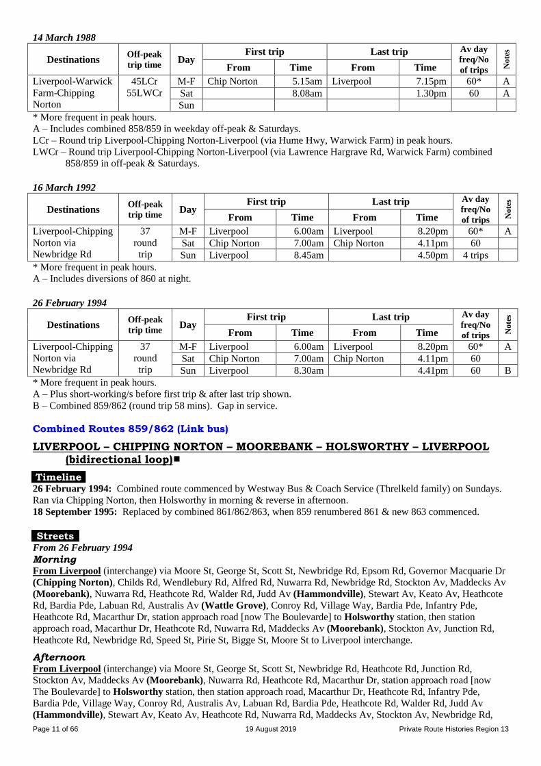
Page 11 of 66 19 August 2019 Private Route Histories Region 13
14 March 1988
Destinations Off-peak
trip time Day
First trip Last trip Av day
freq/No
of trips No
tes
From Time From Time
Liverpool-Warwick
Farm-Chipping
Norton
45LCr
55LWCr
M-F Chip Norton 5.15am Liverpool 7.15pm 60* A
Sat 8.08am 1.30pm 60 A
Sun
* More frequent in peak hours.
A – Includes combined 858/859 in weekday off-peak & Saturdays.
LCr – Round trip Liverpool-Chipping Norton-Liverpool (via Hume Hwy, Warwick Farm) in peak hours.
LWCr – Round trip Liverpool-Chipping Norton-Liverpool (via Lawrence Hargrave Rd, Warwick Farm) combined
858/859 in off-peak & Saturdays.
16 March 1992
Destinations Off-peak
trip time Day
First trip Last trip Av day
freq/No
of trips No
tes
From Time From Time
Liverpool-Chipping
Norton via
Newbridge Rd
37
round
trip
M-F Liverpool 6.00am Liverpool 8.20pm 60* A
Sat Chip Norton 7.00am Chip Norton 4.11pm 60
Sun Liverpool 8.45am 4.50pm 4 trips
* More frequent in peak hours. A – Includes diversions of 860 at night.
26 February 1994
Destinations Off-peak
trip time Day
First trip Last trip Av day
freq/No
of trips No
tes
From Time From Time
Liverpool-Chipping
Norton via
Newbridge Rd
37
round
trip
M-F Liverpool 6.00am Liverpool 8.20pm 60* A
Sat Chip Norton 7.00am Chip Norton 4.11pm 60
Sun Liverpool 8.30am 4.41pm 60 B
* More frequent in peak hours. A – Plus short-working/s before first trip & after last trip shown.
B – Combined 859/862 (round trip 58 mins). Gap in service.
Combined Routes 859/862 (Link bus)
LIVERPOOL – CHIPPING NORTON – MOOREBANK – HOLSWORTHY – LIVERPOOL (bidirectional loop)
Timeline 26 February 1994: Combined route commenced by Westway Bus & Coach Service (Threlkeld family) on Sundays.
Ran via Chipping Norton, then Holsworthy in morning & reverse in afternoon. 18 September 1995: Replaced by combined 861/862/863, when 859 renumbered 861 & new 863 commenced.
Streets
From 26 February 1994
Morning From Liverpool (interchange) via Moore St, George St, Scott St, Newbridge Rd, Epsom Rd, Governor Macquarie Dr
(Chipping Norton), Childs Rd, Wendlebury Rd, Alfred Rd, Nuwarra Rd, Newbridge Rd, Stockton Av, Maddecks Av
(Moorebank), Nuwarra Rd, Heathcote Rd, Walder Rd, Judd Av (Hammondville), Stewart Av, Keato Av, Heathcote
Rd, Bardia Pde, Labuan Rd, Australis Av (Wattle Grove), Conroy Rd, Village Way, Bardia Pde, Infantry Pde,
Heathcote Rd, Macarthur Dr, station approach road [now The Boulevarde] to Holsworthy station, then station
approach road, Macarthur Dr, Heathcote Rd, Nuwarra Rd, Maddecks Av (Moorebank), Stockton Av, Junction Rd,
Heathcote Rd, Newbridge Rd, Speed St, Pirie St, Bigge St, Moore St to Liverpool interchange.
Afternoon From Liverpool (interchange) via Moore St, George St, Scott St, Newbridge Rd, Heathcote Rd, Junction Rd,
Stockton Av, Maddecks Av (Moorebank), Nuwarra Rd, Heathcote Rd, Macarthur Dr, station approach road [now
The Boulevarde] to Holsworthy station, then station approach road, Macarthur Dr, Heathcote Rd, Infantry Pde,
Bardia Pde, Village Way, Conroy Rd, Australis Av, Labuan Rd, Bardia Pde, Heathcote Rd, Walder Rd, Judd Av
(Hammondville), Stewart Av, Keato Av, Heathcote Rd, Nuwarra Rd, Maddecks Av, Stockton Av, Newbridge Rd,

Page 12 of 66 19 August 2019 Private Route Histories Region 13
Epsom Rd, Governor Macquarie Dr (Chipping Norton), Childs Rd, Wendlebury Rd, Alfred Rd, Nuwarra Rd,
Newbridge Rd, Speed St, Pirie St, Bigge St, Moore St to Liverpool interchange.
Route 860
LIVERPOOL – BANKSTOWN (“RED ARROW”)
Timeline 27 February 1984: As part of reorganisation of Milperra Bus Service’s routes & South Western Coach Lines’ South
Bankstown routes:
New route commenced, being an amalgamation of:
12 [1925 number] Bankstown – Milperra Bridge (previously run by South Western Coach Lines, but
transferred on trial to Milperra Bus Service)
69 [1925 number] Liverpool – Milperra Bridge via Newbridge Rd (run by Milperra Bus Service)
Initially on 6 months’ trial. After the trial period, 12 was formally transferred from South Western Coach
Lines to Milperra Bus Service.
Unlike other “Red Arrow” routes, always ran all stops.
After the initial timetable, the operator ceased to refer to the service as a “Red Arrow”.
Operated by Milperra Bus Service (DG (Ray?) Moore).
1 July 1987: Transferred to Westway Bus & Coach Service (Threlkeld family).
By 5 August 1991: Rerouted via Macarthur Institute of Higher Education, Milperra campus [now University of
Western Sydney, Bankstown campus], replacing 861.
7 July 2003: Operator’s name changed to Transit First.
18 September 2006: Amalgamated with 486 and extended from Strathfield to Burwood as 900, Liverpool –
Bankstown – Strathfield – Burwood, as a result of Ministry of Transport review of Region 13.
For details of routes as from 18 September 2006, see (B) Route Histories as from 18 September 2006 below.
Streets
From 27 February 1984
From Liverpool (interchange) via Moore St, George St, Scott St, Newbridge Rd, Milperra Rd (Milperra),
Canterbury Rd, Chapel Rd, Greenfield Pde, Restwell St, South Tce to Bankstown interchange.
From Bankstown (interchange, South Pde) via West Tce, Raymond St, Restwell St, Macauley Av, Chapel Rd,
Canterbury Rd, Milperra Rd (Milperra), Newbridge Rd, Speed St, Pirie St, Bigge St, Moore St to Liverpool
interchange.
Alterations
By 5 August 1991: Ex Liverpool from Milperra Rd via Ashford Av, Bullecourt Av (University of Western
Sydney, Bankstown campus), Horsley Rd, Amour St, Marigold St to Milperra Rd. Reverse on return.
By 18 September 1995: From Liverpool interchange via Moore St, College St, Elizabeth St, George St.
Unaltered ex Bankstown.
By 3 November 1996: To approach Bankstown from Chapel Rd via Macauley Av, Restwell St, South Tce.
Unaltered ex Bankstown.
Timetable Summary 27 February 1984
Destinations Off-peak
trip time Day
First trip Last trip Av day
freq/No
of trips No
tes
From Time From Time
Liverpool-
Bankstown via
Milperra Rd
27 M-F Liverpool 5.31am Bankstown 6.30pm 60*
Sat 7.01am 1.36pm 60
Sun
* More frequent in peak hours.
Page 13 of 66 19 August 2019 Private Route Histories Region 13
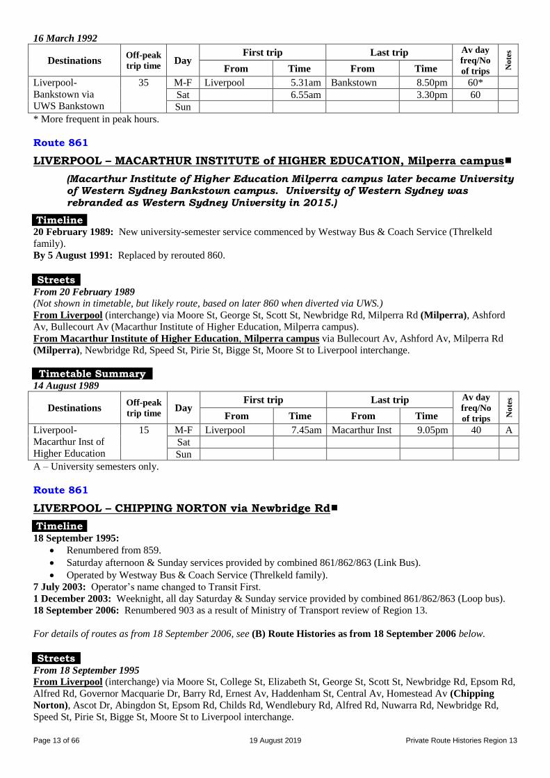
16 March 1992
Destinations Off-peak
trip time Day
First trip Last trip Av day
freq/No
of trips No
tes
From Time From Time
Liverpool-
Bankstown via
UWS Bankstown
35 M-F Liverpool 5.31am Bankstown 8.50pm 60*
Sat 6.55am 3.30pm 60
Sun
* More frequent in peak hours.
Route 861
LIVERPOOL – MACARTHUR INSTITUTE of HIGHER EDUCATION, Milperra campus
(Macarthur Institute of Higher Education Milperra campus later became University of Western Sydney Bankstown campus. University of Western Sydney was
rebranded as Western Sydney University in 2015.)
Timeline 20 February 1989: New university-semester service commenced by Westway Bus & Coach Service (Threlkeld
family).
By 5 August 1991: Replaced by rerouted 860. Streets
From 20 February 1989
(Not shown in timetable, but likely route, based on later 860 when diverted via UWS.)
From Liverpool (interchange) via Moore St, George St, Scott St, Newbridge Rd, Milperra Rd (Milperra), Ashford
Av, Bullecourt Av (Macarthur Institute of Higher Education, Milperra campus).
From Macarthur Institute of Higher Education, Milperra campus via Bullecourt Av, Ashford Av, Milperra Rd
(Milperra), Newbridge Rd, Speed St, Pirie St, Bigge St, Moore St to Liverpool interchange.
Timetable Summary 14 August 1989
Destinations Off-peak
trip time Day
First trip Last trip Av day
freq/No
of trips No
tes
From Time From Time
Liverpool-
Macarthur Inst of
Higher Education
15 M-F Liverpool 7.45am Macarthur Inst 9.05pm 40 A
Sat
Sun
A – University semesters only.
Route 861
LIVERPOOL – CHIPPING NORTON via Newbridge Rd
Timeline 18 September 1995:
Renumbered from 859.
Saturday afternoon & Sunday services provided by combined 861/862/863 (Link Bus).
Operated by Westway Bus & Coach Service (Threlkeld family).
7 July 2003: Operator’s name changed to Transit First.
1 December 2003: Weeknight, all day Saturday & Sunday service provided by combined 861/862/863 (Loop bus).
18 September 2006: Renumbered 903 as a result of Ministry of Transport review of Region 13.
For details of routes as from 18 September 2006, see (B) Route Histories as from 18 September 2006 below.
Streets
From 18 September 1995
From Liverpool (interchange) via Moore St, College St, Elizabeth St, George St, Scott St, Newbridge Rd, Epsom Rd,
Alfred Rd, Governor Macquarie Dr, Barry Rd, Ernest Av, Haddenham St, Central Av, Homestead Av (Chipping
Norton), Ascot Dr, Abingdon St, Epsom Rd, Childs Rd, Wendlebury Rd, Alfred Rd, Nuwarra Rd, Newbridge Rd,
Speed St, Pirie St, Bigge St, Moore St to Liverpool interchange.
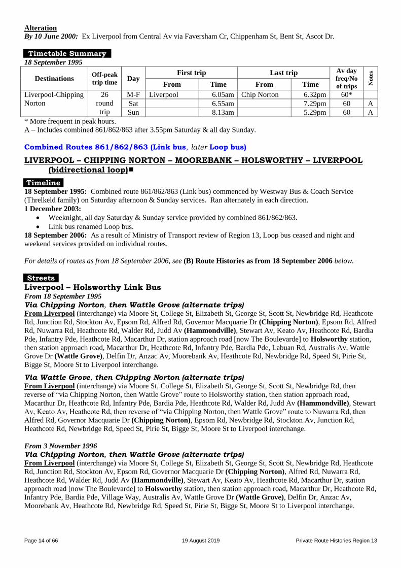
Page 14 of 66 19 August 2019 Private Route Histories Region 13
Alteration
By 10 June 2000: Ex Liverpool from Central Av via Faversham Cr, Chippenham St, Bent St, Ascot Dr.
Timetable Summary 18 September 1995
Destinations Off-peak
trip time Day
First trip Last trip Av day
freq/No
of trips No
tes
From Time From Time
Liverpool-Chipping
Norton
26
round
trip
M-F Liverpool 6.05am Chip Norton 6.32pm 60*
Sat 6.55am 7.29pm 60 A
Sun 8.13am 5.29pm 60 A
* More frequent in peak hours. A – Includes combined 861/862/863 after 3.55pm Saturday & all day Sunday.
Combined Routes 861/862/863 (Link bus, later Loop bus)
LIVERPOOL – CHIPPING NORTON – MOOREBANK – HOLSWORTHY – LIVERPOOL (bidirectional loop)
Timeline 18 September 1995: Combined route 861/862/863 (Link bus) commenced by Westway Bus & Coach Service
(Threlkeld family) on Saturday afternoon & Sunday services. Ran alternately in each direction.
1 December 2003:
Weeknight, all day Saturday & Sunday service provided by combined 861/862/863.
Link bus renamed Loop bus.
18 September 2006: As a result of Ministry of Transport review of Region 13, Loop bus ceased and night and
weekend services provided on individual routes.
For details of routes as from 18 September 2006, see (B) Route Histories as from 18 September 2006 below.
Streets
Liverpool – Holsworthy Link Bus From 18 September 1995
Via Chipping Norton, then Wattle Grove (alternate trips) From Liverpool (interchange) via Moore St, College St, Elizabeth St, George St, Scott St, Newbridge Rd, Heathcote
Rd, Junction Rd, Stockton Av, Epsom Rd, Alfred Rd, Governor Macquarie Dr (Chipping Norton), Epsom Rd, Alfred
Rd, Nuwarra Rd, Heathcote Rd, Walder Rd, Judd Av (Hammondville), Stewart Av, Keato Av, Heathcote Rd, Bardia
Pde, Infantry Pde, Heathcote Rd, Macarthur Dr, station approach road [now The Boulevarde] to Holsworthy station,
then station approach road, Macarthur Dr, Heathcote Rd, Infantry Pde, Bardia Pde, Labuan Rd, Australis Av, Wattle
Grove Dr (Wattle Grove), Delfin Dr, Anzac Av, Moorebank Av, Heathcote Rd, Newbridge Rd, Speed St, Pirie St,
Bigge St, Moore St to Liverpool interchange.
Via Wattle Grove, then Chipping Norton (alternate trips) From Liverpool (interchange) via Moore St, College St, Elizabeth St, George St, Scott St, Newbridge Rd, then
reverse of “via Chipping Norton, then Wattle Grove” route to Holsworthy station, then station approach road,
Macarthur Dr, Heathcote Rd, Infantry Pde, Bardia Pde, Heathcote Rd, Walder Rd, Judd Av (Hammondville), Stewart
Av, Keato Av, Heathcote Rd, then reverse of “via Chipping Norton, then Wattle Grove” route to Nuwarra Rd, then
Alfred Rd, Governor Macquarie Dr (Chipping Norton), Epsom Rd, Newbridge Rd, Stockton Av, Junction Rd,
Heathcote Rd, Newbridge Rd, Speed St, Pirie St, Bigge St, Moore St to Liverpool interchange.
From 3 November 1996
Via Chipping Norton, then Wattle Grove (alternate trips) From Liverpool (interchange) via Moore St, College St, Elizabeth St, George St, Scott St, Newbridge Rd, Heathcote
Rd, Junction Rd, Stockton Av, Epsom Rd, Governor Macquarie Dr (Chipping Norton), Alfred Rd, Nuwarra Rd,
Heathcote Rd, Walder Rd, Judd Av (Hammondville), Stewart Av, Keato Av, Heathcote Rd, Macarthur Dr, station
approach road [now The Boulevarde] to Holsworthy station, then station approach road, Macarthur Dr, Heathcote Rd,
Infantry Pde, Bardia Pde, Village Way, Australis Av, Wattle Grove Dr (Wattle Grove), Delfin Dr, Anzac Av,
Moorebank Av, Heathcote Rd, Newbridge Rd, Speed St, Pirie St, Bigge St, Moore St to Liverpool interchange.

Page 15 of 66 19 August 2019 Private Route Histories Region 13
Via Wattle Grove, then Chipping Norton (alternate trips) From Liverpool (interchange) via Moore St, College St, Elizabeth St, George St, Scott St, Newbridge Rd, then
reverse of “via Chipping Norton, then Wattle Grove” route to Holsworthy station, then station approach road [now
The Boulevarde], Macarthur Dr, Heathcote Rd, Walder Rd, Judd Av (Hammondville), Stewart Av, Keato Av,
Heathcote Rd, Nuwarra Rd, Alfred Rd, Governor Macquarie Dr (Chipping Norton), Epsom Rd, Newbridge Rd,
Stockton Av, Junction Rd, Heathcote Rd, Newbridge Rd, Speed St, Pirie St, Bigge St, Moore St to Liverpool
interchange.
Alterations
From 10 June 2000 (via Chipping Norton, then Wattle Grove): From Epsom Rd via Abingdon St, Ascot Dr,
Bent St, Chippenham St, Faversham Cr, Central Av, Haddenham St, Ernest Av, Barry Rd, Governor
Macquarie Dr.
From 10 June 2000 (via Wattle Grove, then Chipping Norton): Reverse of “Via Chipping Norton, then
Wattle Grove.”
From 20 April 2002 (via Wattle Grove, then Chipping Norton): From Holsworthy station via station
approach road [now The Boulevarde], Macarthur Dr, Heathcote Rd, Keato Av, Stewart Av, Judd Av
(Hammondville), Walder Rd, Heathcote Rd. Opposite direction unaltered.
Liverpool – Holsworthy Loop bus Alterations
From 1 December 2003 (via Chipping Norton, then Wattle Grove): From Epsom Rd via Governor Macquarie
Dr (not via Abingdon St, Ascot Dr, etc).
From 1 December 2003 (via Wattle Grove, then Chipping Norton): Reverse of “Via Chipping Norton, then
Wattle Grove.”
Route 862
LIVERPOOL – HAMMONDVILLE – HOLSWORTHY Extended from Holsworthy to East Hills Hostel [later Voyager Point] & Sandy
Point (selected trips)
Timeline 16 March 1992: Renumbered from part of 42 [1925 number] & rerouted through new suburb of Wattle Grove.
Operated by Westway Bus & Coach Service (Threlkeld family).
26 February 1994: Sunday service provided by combined 859/862 (Link bus).
18 September 1995:
Route split into:
862 Liverpool – Moorebank – Hammondville – Holsworthy (incl selected trips to Sandy Point)
863 Liverpool – Wattle Grove – Holsworthy
Saturday afternoon & Sunday services provided by combined 861/862/863 (Link bus).
7 July 2003: Operator’s name changed to Transit First.
18 September 2006: As a result of Ministry of Transport review of Region 13:
Liverpool – Hammondville – Holsworthy renumbered 902.
Holsworthy – Voyager Point – Sandy Point renumbered 902X.
Loop Bus replaced by night & weekend services on individual routes.
For details of routes as from 18 September 2006, see (B) Route Histories as from 18 September 2006 below.
Streets
Liverpool – Holsworthy (selected trips extended to Sandy Point) From 16 March 1992
From Liverpool (interchange) via Moore St, College St, Elizabeth St, George St, Scott St, Newbridge Rd, Heathcote
Rd, Junction Rd, Stockton Av, Maddecks Av, Nuwarra Rd, Heathcote Rd, Walder Rd, Judd Av (Hammondville),
Stewart Av, Keato Av, Heathcote Rd, Bardia Pde, Labuan Rd, Australis Av (Wattle Grove), Conroy Rd, Village
Way, Bardia Pde, Infantry Pde, Heathcote Rd, Macarthur Dr, station approach road [now The Boulevarde] to
Holsworthy station.
From Holsworthy (station) via reverse route to Labuan Rd, Heathcote Rd, Walder Rd, Judd Av (Hammondville),
Stewart Av, Keato Av, Heathcote Rd, Nuwarra Rd, then reverse route to Newbridge Rd, then Speed St, Pirie St, Bigge
St, Moore St to Liverpool interchange.
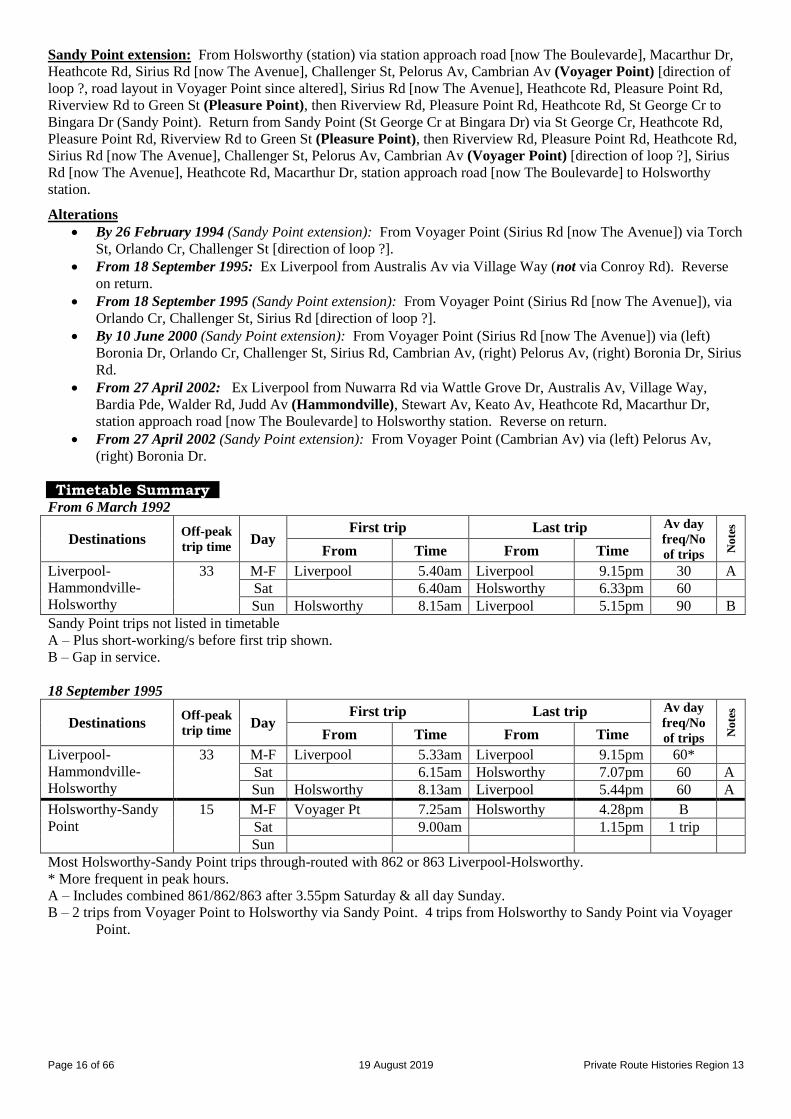
Page 16 of 66 19 August 2019 Private Route Histories Region 13
Sandy Point extension: From Holsworthy (station) via station approach road [now The Boulevarde], Macarthur Dr,
Heathcote Rd, Sirius Rd [now The Avenue], Challenger St, Pelorus Av, Cambrian Av (Voyager Point) [direction of
loop ?, road layout in Voyager Point since altered], Sirius Rd [now The Avenue], Heathcote Rd, Pleasure Point Rd,
Riverview Rd to Green St (Pleasure Point), then Riverview Rd, Pleasure Point Rd, Heathcote Rd, St George Cr to
Bingara Dr (Sandy Point). Return from Sandy Point (St George Cr at Bingara Dr) via St George Cr, Heathcote Rd,
Pleasure Point Rd, Riverview Rd to Green St (Pleasure Point), then Riverview Rd, Pleasure Point Rd, Heathcote Rd,
Sirius Rd [now The Avenue], Challenger St, Pelorus Av, Cambrian Av (Voyager Point) [direction of loop ?], Sirius
Rd [now The Avenue], Heathcote Rd, Macarthur Dr, station approach road [now The Boulevarde] to Holsworthy
station.
Alterations
By 26 February 1994 (Sandy Point extension): From Voyager Point (Sirius Rd [now The Avenue]) via Torch
St, Orlando Cr, Challenger St [direction of loop ?].
From 18 September 1995: Ex Liverpool from Australis Av via Village Way (not via Conroy Rd). Reverse
on return.
From 18 September 1995 (Sandy Point extension): From Voyager Point (Sirius Rd [now The Avenue]), via
Orlando Cr, Challenger St, Sirius Rd [direction of loop ?].
By 10 June 2000 (Sandy Point extension): From Voyager Point (Sirius Rd [now The Avenue]) via (left)
Boronia Dr, Orlando Cr, Challenger St, Sirius Rd, Cambrian Av, (right) Pelorus Av, (right) Boronia Dr, Sirius
Rd.
From 27 April 2002: Ex Liverpool from Nuwarra Rd via Wattle Grove Dr, Australis Av, Village Way,
Bardia Pde, Walder Rd, Judd Av (Hammondville), Stewart Av, Keato Av, Heathcote Rd, Macarthur Dr,
station approach road [now The Boulevarde] to Holsworthy station. Reverse on return.
From 27 April 2002 (Sandy Point extension): From Voyager Point (Cambrian Av) via (left) Pelorus Av,
(right) Boronia Dr.
Timetable Summary From 6 March 1992
Destinations Off-peak
trip time Day
First trip Last trip Av day
freq/No
of trips No
tes
From Time From Time
Liverpool-
Hammondville-
Holsworthy
33 M-F Liverpool 5.40am Liverpool 9.15pm 30 A
Sat 6.40am Holsworthy 6.33pm 60
Sun Holsworthy 8.15am Liverpool 5.15pm 90 B
Sandy Point trips not listed in timetable
A – Plus short-working/s before first trip shown.
B – Gap in service.
18 September 1995
Destinations Off-peak
trip time Day
First trip Last trip Av day
freq/No
of trips No
tes
From Time From Time
Liverpool-
Hammondville-
Holsworthy
33 M-F Liverpool 5.33am Liverpool 9.15pm 60*
Sat 6.15am Holsworthy 7.07pm 60 A Sun Holsworthy 8.13am Liverpool 5.44pm 60 A
Holsworthy-Sandy
Point
15 M-F Voyager Pt 7.25am Holsworthy 4.28pm B
Sat 9.00am 1.15pm 1 trip
Sun
Most Holsworthy-Sandy Point trips through-routed with 862 or 863 Liverpool-Holsworthy.
* More frequent in peak hours. A – Includes combined 861/862/863 after 3.55pm Saturday & all day Sunday.
B – 2 trips from Voyager Point to Holsworthy via Sandy Point. 4 trips from Holsworthy to Sandy Point via Voyager
Point.

Page 17 of 66 19 August 2019 Private Route Histories Region 13
Route 863
LIVERPOOL – WATTLE GROVE – HOLSWORTHY
Diversion via Defence Storage/Moorebank Army Camp
Timeline 18 September 1995:
Liverpool – Wattle Grove (new suburb) – Holsworthy formed as a result of split of 862 into 862 & 863.
Saturday afternoon & Sunday services provided by combined 861/862/863 (Link bus).
Selected trips diverted via Moorebank Army Camp to replace 857.
Operated by Westway Bus & Coach Service (Threlkeld family).
7 July 2003: Operator’s name changed to Transit First.
1 December 2003: Weeknight, all day Saturday & Sunday service provided by combined 861/862/863 (Loop bus).
18 September 2006: As a result of Ministry of Transport review of Region 13:
Renumbered 901.
Loop bus ceased and night and weekend services provided on individual routes. For details of routes as from 18 September 2006, see (B) Route Histories as from 18 September 2006 below.
Streets
From 18 September 1995
From Liverpool (interchange) via Moore St, College St, Elizabeth St, George St, Scott St, Newbridge Rd, Heathcote
Rd, Moorebank Av, Anzac Rd, Delfin Dr, Wattle Grove Dr (Wattle Grove), Australis Av, Conroy Rd, Bardia Pde,
Infantry Pde, Heathcote Rd, Macarthur Dr, station approach road [now The Boulevarde] to Holsworthy station.
From Holsworthy (station) via reverse route to Newbridge Rd, then Speed St, Pirie St, Bigge St, Moore St to
Liverpool interchange.
Alteration
From 27 April 2002: Ex Liverpool from Australis Av via Village Way (not via Conroy Rd). Reverse on return.
Timetable Summary 18 September 1995
Destinations Off-peak
trip time Day
First trip Last trip Av day
freq/No
of trips No
tes
From Time From Time
Liverpool-Wattle
Grove-Holsworthy
33 M-F Liverpool 6.15am Liverpool 8.15pm 60* A
Sat 6.15am Holsworthy 7.12pm 60 B Sun Holsworthy 8.13am Liverpool 5.44pm 60 B
* More frequent in peak hours. A – Plus short-working/s before first trip shown.
B – Includes combined 861/862/863 after 3.55pm Saturday & all day Sunday.
Route 902
PARRAMATTA – GRANVILLE – VILLAWOOD – BANKSTOWN
Timeline 29 July 1987: Parramatta – Granville – Villawood renumbered from 186 [1925 number]. Operated by Delwood
Coaches.
2 April 1992: Transferred to Baxter’s Bus Lines.
1 August 1993: Most trips rerouted between Parramatta & Granville via Harris Park instead of Church St.
17 December 1995: Amalgamated with 21 [1925 number], Villawood – Bankstown, as 902, Parramatta – Villawood
– Bankstown. All trips via Harris Park.
1 January 2005: Transferred to Connex NSW.
18 April 2006: Operator’s name changed to Veolia Transport.
18 September 2006: Renumbered 907 as a result of Ministry of Transport review of Region 13.
For details of routes as from 18 September 2006, see (B) Route Histories as from 18 September 2006 below.

Page 18 of 66 19 August 2019 Private Route Histories Region 13
Streets
Parramatta – Villawood From 29 July 1987
From Parramatta (Market St) via Church St, George St, Smith St, Darcy St, Church St, Parramatta Rd, Bold St,
Railway Pde, South St, Mary St, Granville interchange, Railway Pde, Milton St, Halsall St, Woodville Rd, Tangerine
St, Mandarin St, River Av, Woodville Rd, Villawood Rd, Villawood Pl to Villawood station.
From Villawood (Villawood Pl at station) via reverse route to Milton St, then Railway Pde, South St, Granville
interchange, Railway Pde, Bold St, Gt Western Hwy, Church St, Argyle St, Marsden St, Market St at Church St
(Parramatta).
Trips direct via Woodville Rd: Direct via Woodville Rd (not via Tangerine St, Mandarin St & River Av).
From 1 August 1993
From Parramatta (Argyle St at Westfield) via Argyle St, Marsden St, George St, Smith St, Darcy St, Church St,
Parkes St, Wigram St, Una St (Harris Park), Harris St, Allen St, Good St, Cowper St, Bold St, Railway Pde, South
St, Mary St, Granville interchange, Railway Pde, Milton St, Halsall St, Woodville Rd, Tangerine St, Mandarin St,
River Av, Woodville Rd, Villawood Rd, Villawood Pl to Villawood station.
From Villawood (Villawood Pl at station) via reverse route to Milton St, then Railway Pde, South St, Granville
interchange, Railway Pde, Bold St, then reverse route to Parkes St, then Station St, Darcy St, Church St, Argyle St to
Westfield (Parramatta).
Parramatta – Villawood – Bankstown From 17 December 1995
From Parramatta (Argyle St at Westfield) via Argyle St, Marsden St, George St, Smith St, Darcy St, Church St,
Parkes St, Wigram St, Una St, Harris St, Allen St, Good St, Cowper St, Bold St, Railway Pde, South St, Mary St,
Granville interchange, Railway Pde, South St, William St, Woodville Rd, Villawood Rd, Villawood Pl (Villawood),
Woodville Rd, Hume Hwy (Yagoona), Highland Av, Glassop St, Allum St, Melanie St, Brancourt Av, Carmen St,
Meredith St, Marion St, Chapel Rd, The Mall, Jacobs St, Bankstown Square bus terminal.
From Bankstown Square (bus terminal) via The Mall, The Appian Way, North Tce, Fetherston St, The Mall, Chapel
Rd, then reverse route to William St, then South St, Mary St, Granville interchange, Railway Pde, Bold St, then
reverse route to Parkes St, then Station St, Darcy St, Church St, Argyle St to Westfield (Parramatta).
Alteration
From 19 February 2006 (opening of new Parramatta interchange): Parramatta terminus at new interchange (Argyle
St). (?) route to approach and leave Parramatta.
Timetable Summary 29 July 1987
Destinations Off-peak
trip time Day
First trip Last trip Av day
freq/No
of trips No
tes
From Time From Time
Parramatta-
Villawood
33 M-F Villawood 5.20pmP Villawood 8.10pmP 25* A
Sat 6.45amP Parramatta 7.45pmV 35**
Sun 8.25amG Granville 7.40pmV 60 B
* More frequent in peak hours.
** Less frequent in afternoon. A – Plus short-working/s after last trip shown. Extra trip Thursday night.
B – Selected trips extended from Granville to Parramatta via Rosehill.
G – To Granville.
P – To Parramatta.
V – To Villawood.
17 December 1995
Destinations Off-peak
trip time Day
First trip Last trip Av day
freq/No
of trips No
tes
From Time From Time
Parramatta-
Villawood-
Bankstown
56 M-F Parramatta 5.22am Bankstown 8.10pm 30 A
Sat 7.40am 6.35pm 60 A
Sun 7.56am 5.35pm 60 A
A – Plus short-working/s before first trip & after last trip shown.

Page 19 of 66 19 August 2019 Private Route Histories Region 13
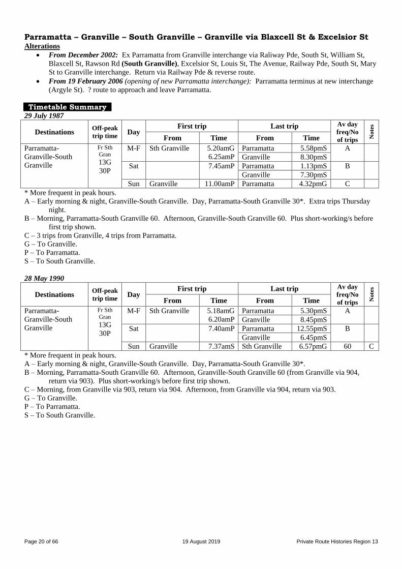
Route 903
PARRAMATTA – GRANVILLE – SOUTH GRANVILLE via Excelsior St (also via Blaxcell St at various times)
Merrylands – Granville – South Granville (Sundays only)
Timeline 29 July 1987: Parramatta – Granville – South Granville via Excelsior St renumbered from 96 [1925 number].
Operated by Delwood Coaches.
28 May 1990: Weeknight, Saturday afternoon & Sunday services provided by combined 903/904.
2 April 1992: Transferred to Baxter’s Bus Lines.
1 August 1993:
Altered to run in loop south of Granville, outwards via Blaxcell St & in via Excelsior St, as part of a
reorganisation of 903, 904, 905 & 910.
Shared route along Excelsior St & Blaxcell St with 905.
Sunday service, Merrylands – Granville – South Granville (loop from Granville via Blaxcell St & return via
Excelsior St).
17 December 1995:
Reverted to Parramatta – Granville – South Granville via Excelsior St.
Shared route between Granville & Parramatta & along Excelsior St with 905.
Sunday service provided by 905.
December 2002: Altered to run:
From Parramatta to Granville, then via Blaxcell St to South Granville & return via Excelsior St to Granville.
From Granville via Excelsior St to South Granville & return via Blaxcell St to Granville, then to Parramatta.
Shared most of route with 905.
1 January 2005: Transferred to Connex NSW.
18 April 2006: Operator’s name changed to Veolia Transport
18 September 2006: Replaced by new 906 in Excelsior St, by 910 in Blaxcell St & by parts of 909 in Rosehill, as a
result of Ministry of Transport review of Region 13.
For details of routes as from 18 September 2006, see (B) Route Histories as from 18 September 2006 below.
Streets
Parramatta – Granville – South Granville via Excelsior St From 29 July 1987
From Parramatta (Market St) via Church St, Phillip St, Smith St, George St, Alfred St, Gray St, Good St, Cowper
St, Bold St, Railway Pde, South St, Mary St, Granville interchange, Railway Pde, The Avenue, Louis St, Excelsior St
to Rawson Rd (South Granville).
From South Granville (Excelsior St/Rawson Rd) via Rawson Rd, Robertson St, Guildford Rd, Excelsior St, Louis St,
The Avenue, William St, Lumley St, Mary St, Granville interchange, Railway Pde, Bold St, then reverse route to
Alfred St, then Noller Pde, Purchase St, Hassall St, Parkes St, Wigram St, Hassall St, Station St, Darcy St, Church St,
Argyle St, Marsden St, Market St at Church St (Parramatta).
Parramatta – Granville – South Granville loop via Excelsior St & Blaxcell St From 1 August 1993
From Parramatta (Argyle St at Westfield) via Argyle St, Marsden St, George St, Alfred St, Gray St, Good St,
Cowper St, Bold St, Railway Pde, South St, Mary St, Granville interchange, Railway Pde, South St, William St,
Blaxcell St, Rawson Rd (South Granville), Robertson St, Guildford Rd, Excelsior St, Louis St, Blaxcell St, William
St, Mary St, Granville interchange, Railway Pde, Bold St, then reverse route to Alfred St, then Noller Pde, Purchase
St, Hassall St, Parkes St, Station St, Darcy St, Church St, Argyle St to Westfield (Parramatta).
Parramatta – Granville – South Granville via Excelsior St From 17 December 1995
From Parramatta (Argyle St at Westfield) via Argyle St, Marsden St, George St, Alfred St, Gray St, Good St,
Cowper St, Bold St, Railway Pde, South St, Mary St, Granville interchange, Railway Pde, The Avenue, Louis St,
Excelsior St, Guildford Rd, Robertson St to Rawson Rd (South Granville).
From South Granville (Robertson St/Rawson Rd) via Rawson Rd, Excelsior St, Louis St, The Avenue, Railway Pde,
South St, Mary St, Granville interchange, Railway Pde, Bold St, then reverse route to Alfred St, then Noller Pde,
Purchase St, Hassall St, Parkes St, Station St, Darcy St, Church St, Argyle St to Westfield (Parramatta).
Page 20 of 66 19 August 2019 Private Route Histories Region 13
Parramatta – Granville – South Granville – Granville via Blaxcell St & Excelsior St Alterations
From December 2002: Ex Parramatta from Granville interchange via Raliway Pde, South St, William St,
Blaxcell St, Rawson Rd (South Granville), Excelsior St, Louis St, The Avenue, Railway Pde, South St, Mary
St to Granville interchange. Return via Railway Pde & reverse route.
From 19 February 2006 (opening of new Parramatta interchange): Parramatta terminus at new interchange
(Argyle St). ? route to approach and leave Parramatta.
Timetable Summary 29 July 1987
Destinations Off-peak
trip time Day
First trip Last trip Av day
freq/No
of trips No
tes
From Time From Time
Parramatta-
Granville-South
Granville
Fr Sth
Gran
13G
30P
M-F Sth Granville 5.20amG
6.25amP
Parramatta 5.58pmS A
Granville 8.30pmS
Sat 7.45amP Parramatta 1.13pmS B
Granville 7.30pmS
Sun Granville 11.00amP Parramatta 4.32pmG C
* More frequent in peak hours. A – Early morning & night, Granville-South Granville. Day, Parramatta-South Granville 30*. Extra trips Thursday
night.
B – Morning, Parramatta-South Granville 60. Afternoon, Granville-South Granville 60. Plus short-working/s before
first trip shown.
C – 3 trips from Granville, 4 trips from Parramatta.
G – To Granville.
P – To Parramatta.
S – To South Granville.
28 May 1990
Destinations Off-peak
trip time Day
First trip Last trip Av day
freq/No
of trips No
tes
From Time From Time
Parramatta-
Granville-South
Granville
Fr Sth
Gran
13G
30P
M-F Sth Granville 5.18amG
6.20amP
Parramatta 5.30pmS A
Granville 8.45pmS
Sat 7.40amP Parramatta 12.55pmS B
Granville 6.45pmS
Sun Granville 7.37amS Sth Granville 6.57pmG 60 C
* More frequent in peak hours. A – Early morning & night, Granville-South Granville. Day, Parramatta-South Granville 30*.
B – Morning, Parramatta-South Granville 60. Afternoon, Granville-South Granville 60 (from Granville via 904,
return via 903). Plus short-working/s before first trip shown.
C – Morning, from Granville via 903, return via 904. Afternoon, from Granville via 904, return via 903.
G – To Granville.
P – To Parramatta.
S – To South Granville.
Page 21 of 66 19 August 2019 Private Route Histories Region 13
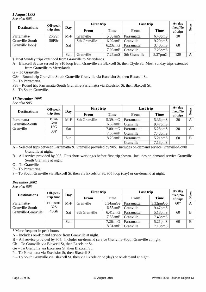
1 August 1993
See also 905
Destinations Off-peak
trip time Day
First trip Last trip Av day
freq/No
of trips No
tes
From Time From Time
Parramatta-
Granville-South
Granville loop†
26GSr
50PSr
M-F Granville 5.30amS Parramatta 6.40pmS 30
Sth Granville 6.02amP Granville 9.20pmS
Sat 6.23amG
7.02amP
Parramatta 3.40pmS 60
Granville 7.25pmS
Sun Granville 7.27amS Sth Granville 5.37pmG 120 A
† Most Sunday trips extended from Granville to Merrylands.
A – Blaxcell St also served by 910 loop from Granville via Blaxcell St, then Clyde St. Most Sunday trips extended
from Granville to Merrylands.
G – To Granville.
GSr – Round trip Granville-South Granville-Granville via Excelsior St, then Blaxcell St.
P – To Parramatta.
PSr – Round trip Parramatta-South Granville-Parramatta via Excelsior St, then Blaxcell St.
S – To South Granville.
17 December 1995
See also 905
Destinations Off-peak
trip time Day
First trip Last trip Av day
freq/No
of trips No
tes
From Time From Time
Parramatta-
Granville-South
Granville
Fr Sth
Gran
13G
30P
M-F Sth Granville 5.39amG
6.59amP
Parramatta 5.36pmS 30 A
Granville 9.47pmS
Sat 7.00amG
7.56amP
Parramatta 5.28pmS 30 A
Granville 7.43pmS
Sun 8.29amP Parramatta 5.21pmS 60 B
Granville 7.13pmS
A – Selected trips between Parramatta & Granville provided by 905. Includes on-demand service Granville-South
Granville at night.
B – All service provided by 905. Plus short-working/s before first trip shown. Includes on-demand service Granville-
South Granville at night.
G – To Granville.
P – To Parramatta.
S – To South Granville via Blaxcell St, then via Excelsior St, 905 loop (day) or on-demand at night.
December 2002
See also 905
Destinations Off-peak
trip time Day
First trip Last trip Av day
freq/No
of trips No
tes
From Time From Time
Parramatta-
Granville-South
Granville-Granville
Fr P’matta
32S
45Gb
M-F Granville 5.34amGe
6.55amP
Parramatta 3.32pmGb 60* A
Granville 9.47pmS
Sat Sth Granville 6.41amG
7.55amP
Parramatta 5.18pmS 60 B
Granville 7.43pmS
Sun 7.26amG
8.31amP
Parramatta 5.21pmS 60 B
Granville 7.13pmS
* More frequent in peak hours. A – Includes on-demand service from Granville at night.
B – All service provided by 905. Includes on-demand service Granville-South Granville at night.
Gb – To Granville via Blaxcell St, then Excelsior St.
Ge – To Granville via Excelsior St, then Blaxcell St.
P – To Parramatta via Excelsior St, then Blaxcell St.
S – To South Granville via Blaxcell St, then via Excelsior St (day) or on-demand at night.
Page 22 of 66 19 August 2019 Private Route Histories Region 13
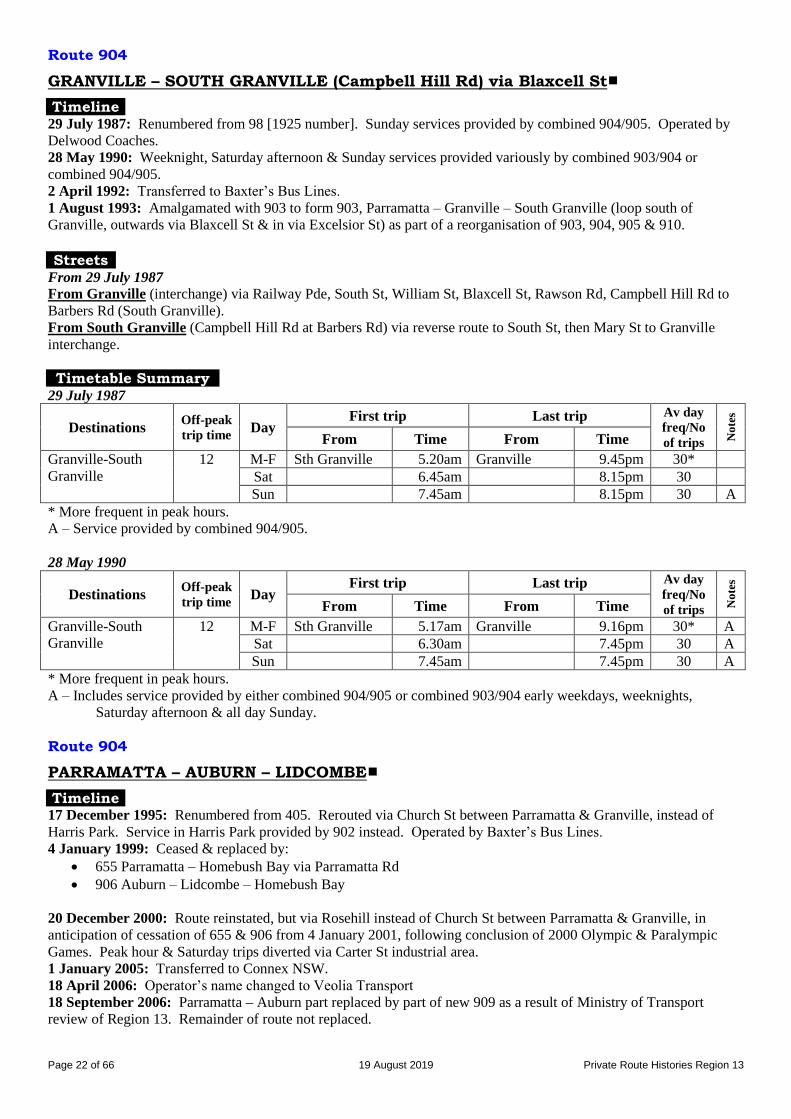
Route 904
GRANVILLE – SOUTH GRANVILLE (Campbell Hill Rd) via Blaxcell St
Timeline 29 July 1987: Renumbered from 98 [1925 number]. Sunday services provided by combined 904/905. Operated by
Delwood Coaches.
28 May 1990: Weeknight, Saturday afternoon & Sunday services provided variously by combined 903/904 or
combined 904/905.
2 April 1992: Transferred to Baxter’s Bus Lines.
1 August 1993: Amalgamated with 903 to form 903, Parramatta – Granville – South Granville (loop south of
Granville, outwards via Blaxcell St & in via Excelsior St) as part of a reorganisation of 903, 904, 905 & 910. Streets
From 29 July 1987
From Granville (interchange) via Railway Pde, South St, William St, Blaxcell St, Rawson Rd, Campbell Hill Rd to
Barbers Rd (South Granville).
From South Granville (Campbell Hill Rd at Barbers Rd) via reverse route to South St, then Mary St to Granville
interchange.
Timetable Summary 29 July 1987
Destinations Off-peak
trip time Day
First trip Last trip Av day
freq/No
of trips No
tes
From Time From Time
Granville-South
Granville
12 M-F Sth Granville 5.20am Granville 9.45pm 30*
Sat 6.45am 8.15pm 30
Sun 7.45am 8.15pm 30 A
* More frequent in peak hours. A – Service provided by combined 904/905.
28 May 1990
Destinations Off-peak
trip time Day
First trip Last trip Av day
freq/No
of trips No
tes
From Time From Time
Granville-South
Granville
12 M-F Sth Granville 5.17am Granville 9.16pm 30* A Sat 6.30am 7.45pm 30 A Sun 7.45am 7.45pm 30 A
* More frequent in peak hours. A – Includes service provided by either combined 904/905 or combined 903/904 early weekdays, weeknights,
Saturday afternoon & all day Sunday.
Route 904
PARRAMATTA – AUBURN – LIDCOMBE
Timeline 17 December 1995: Renumbered from 405. Rerouted via Church St between Parramatta & Granville, instead of
Harris Park. Service in Harris Park provided by 902 instead. Operated by Baxter’s Bus Lines.
4 January 1999: Ceased & replaced by:
655 Parramatta – Homebush Bay via Parramatta Rd
906 Auburn – Lidcombe – Homebush Bay
20 December 2000: Route reinstated, but via Rosehill instead of Church St between Parramatta & Granville, in
anticipation of cessation of 655 & 906 from 4 January 2001, following conclusion of 2000 Olympic & Paralympic
Games. Peak hour & Saturday trips diverted via Carter St industrial area.
1 January 2005: Transferred to Connex NSW.
18 April 2006: Operator’s name changed to Veolia Transport
18 September 2006: Parramatta – Auburn part replaced by part of new 909 as a result of Ministry of Transport
review of Region 13. Remainder of route not replaced.
Page 23 of 66 19 August 2019 Private Route Histories Region 13
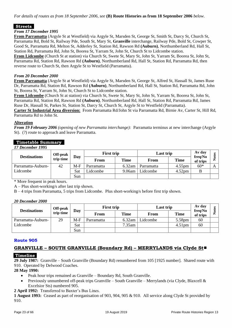
For details of routes as from 18 September 2006, see (B) Route Histories as from 18 September 2006 below.
Streets
From 17 December 1995
From Parramatta (Argyle St at Westfield) via Argyle St, Marsden St, George St, Smith St, Darcy St, Church St,
Parramatta Rd, Bold St, Railway Pde, South St, Mary St, Granville interchange, Railway Pde, Bold St, Cowper St,
Good St, Parramatta Rd, Melton St, Adderley St, Station Rd, Rawson Rd (Auburn), Northumberland Rd, Hall St,
Station Rd, Parramatta Rd, John St, Boorea St, Yarram St, John St, Church St to Lidcombe station.
From Lidcombe (Church St at station) via Church St, Swete St, Mary St, John St, Yarram St, Boorea St, John St,
Parramatta Rd, Station Rd, Rawson Rd (Auburn), Northumberland Rd, Hall St, Station Rd, Parramatta Rd, then
reverse route to Church St, then Argyle St to Westfield (Parramatta).
From 20 December 2000
From Parramatta (Argyle St at Westfield) via Argyle St, Marsden St, George St, Alfred St, Hassall St, James Ruse
Dr, Parramatta Rd, Station Rd, Rawson Rd (Auburn), Northumberland Rd, Hall St, Station Rd, Parramatta Rd, John
St, Boorea St, Yarram St, John St, Church St to Lidcombe station.
From Lidcombe (Church St at station) via Church St, Swete St, Mary St, John St, Yarram St, Boorea St, John St,
Parramatta Rd, Station Rd, Rawson Rd (Auburn), Northumberland Rd, Hall St, Station Rd, Parramatta Rd, James
Ruse Dr, Hassall St, Parkes St, Station St, Darcy St, Church St, Argyle St to Westfield (Parramatta).
Carter St Industrial Area diversion: From Parramatta Rd/John St via Parramatta Rd, Birnie Av, Carter St, Hill Rd,
Parramatta Rd to John St.
Alteration
From 19 February 2006 (opening of new Parramatta interchange): Parramatta terminus at new interchange (Argyle
St). (?) route to approach and leave Parramatta.
Timetable Summary 17 December 1995
Destinations Off-peak
trip time Day
First trip Last trip Av day
freq/No
of trips No
tes
From Time From Time
Parramatta-Auburn-
Lidcombe
42 M-F Parramatta 6.32am Parramatta 4.55pm 60* A
Sat Lidcombe 9.06am Lidcombe 4.52pm B
Sun
* More frequent in peak hours. A – Plus short-working/s after last trip shown.
B – 4 trips from Parramatta, 5 trips from Lidcombe. Plus short-working/s before first trip shown.
20 December 2000
Destinations Off-peak
trip time Day
First trip Last trip Av day
freq/No
of trips No
tes
From Time From Time
Parramatta-Auburn-
Lidcombe
29 M-F Parramatta 6.32am Lidcombe 5.58pm 60
Sat 7.35am 4.51pm 60
Sun
Route 905
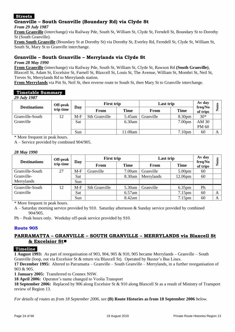
GRANVILLE – SOUTH GRANVILLE (Boundary Rd) – MERRYLANDS via Clyde St
Timeline 29 July 1987: Granville – South Granville (Boundary Rd) renumbered from 105 [1925 number]. Shared route with
910. Operated by Delwood Coaches.
28 May 1990:
Peak hour trips remained as Granville – Boundary Rd, South Granville.
Previously unnumbered off-peak trips Granville – South Granville – Merrylands (via Clyde, Blaxcell &
Excelsior Sts) numbered 905.
2 April 1992: Transferred to Baxter’s Bus Lines.
1 August 1993: Ceased as part of reorganisation of 903, 904, 905 & 910. All service along Clyde St provided by
910.
Page 24 of 66 19 August 2019 Private Route Histories Region 13
Streets
Granville – South Granville (Boundary Rd) via Clyde St From 29 July 1987
From Granville (interchange) via Railway Pde, South St, William St, Clyde St, Ferndell St, Boundary St to Dorothy
St (South Granville).
From South Granville (Boundary St at Dorothy St) via Dorothy St, Everley Rd, Ferndell St, Clyde St, William St,
South St, Mary St to Granville interchange.
Granville – South Granville – Merrylands via Clyde St From 28 May 1990
From Granville (interchange) via Railway Pde, South St, William St, Clyde St, Rawson Rd (South Granville),
Blaxcell St, Adam St, Excelsior St, Farnell St, Blaxcell St, Louis St, The Avenue, William St, Mombri St, Neil St,
Treves St, Merrylands Rd to Merrylands station.
From Merrylands via Pitt St, Neil St, then reverse route to South St, then Mary St to Granville interchange.
Timetable Summary 29 July 1987
Destinations Off-peak
trip time Day
First trip Last trip Av day
freq/No
of trips No
tes
From Time From Time
Granville-South
Granville
12 M-F Sth Granville 5.45am Granville 8.30pm 30*
Sat 6.30am 7.00pm AM 30
PM 60
Sun 11.08am 7.10pm 60 A
* More frequent in peak hours. A – Service provided by combined 904/905.
28 May 1990
Destinations Off-peak
trip time Day
First trip Last trip Av day
freq/No
of trips No
tes
From Time From Time
Granville-South
Granville-
Merrylands
27 M-F Granville 7.00am Granville 5.00pm 60
Sat 8.30am Merrylands 12.06pm 60
Sun
Granville-South
Granville
12 M-F Sth Granville 5.30am Granville 6.35pm Ph
Sat 6.57am 7.15pm 60 A
Sun 8.42am 7.15pm 60 A
* More frequent in peak hours. A – Saturday morning service provided by 910. Saturday afternoon & Sunday service provided by combined
904/905.
Ph – Peak hours only. Weekday off-peak service provided by 910.
Route 905
PARRAMATTA – GRANVILLE – SOUTH GRANVILLE – MERRYLANDS via Blaxcell St & Excelsior St
Timeline 1 August 1993: As part of reorganisation of 903, 904, 905 & 910, 905 became Merrylands – Granville – South
Granville (loop, out via Excelsior St & return via Blaxcell St). Operated by Baxter’s Bus Lines.
17 December 1995: Altered to Parramatta – Granville – South Granville – Merrylands, in a further reorganisation of
903 & 905.
1 January 2005: Transferred to Connex NSW.
18 April 2006: Operator’s name changed to Veolia Transport
18 September 2006: Replaced by 906 along Excelsior St & 910 along Blaxcell St as a result of Ministry of Transport
review of Region 13.
For details of routes as from 18 September 2006, see (B) Route Histories as from 18 September 2006 below.
Page 25 of 66 19 August 2019 Private Route Histories Region 13
Streets
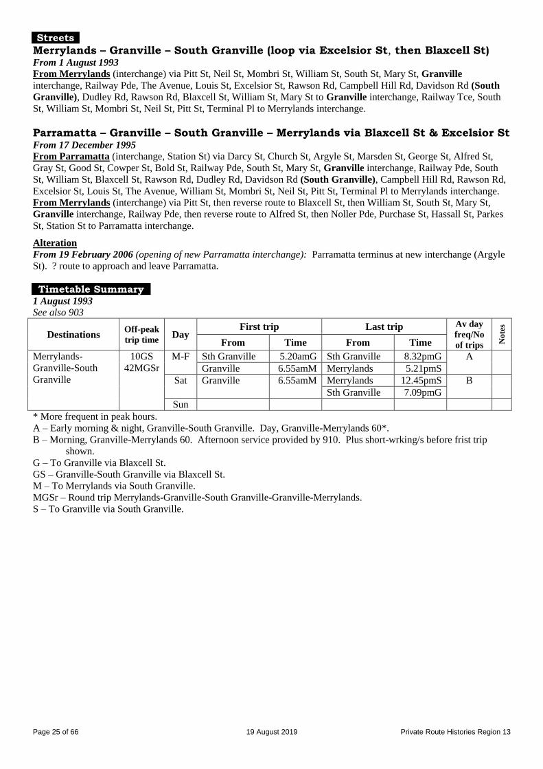
Merrylands – Granville – South Granville (loop via Excelsior St, then Blaxcell St) From 1 August 1993
From Merrylands (interchange) via Pitt St, Neil St, Mombri St, William St, South St, Mary St, Granville
interchange, Railway Pde, The Avenue, Louis St, Excelsior St, Rawson Rd, Campbell Hill Rd, Davidson Rd (South
Granville), Dudley Rd, Rawson Rd, Blaxcell St, William St, Mary St to Granville interchange, Railway Tce, South
St, William St, Mombri St, Neil St, Pitt St, Terminal Pl to Merrylands interchange.
Parramatta – Granville – South Granville – Merrylands via Blaxcell St & Excelsior St From 17 December 1995
From Parramatta (interchange, Station St) via Darcy St, Church St, Argyle St, Marsden St, George St, Alfred St,
Gray St, Good St, Cowper St, Bold St, Railway Pde, South St, Mary St, Granville interchange, Railway Pde, South
St, William St, Blaxcell St, Rawson Rd, Dudley Rd, Davidson Rd (South Granville), Campbell Hill Rd, Rawson Rd,
Excelsior St, Louis St, The Avenue, William St, Mombri St, Neil St, Pitt St, Terminal Pl to Merrylands interchange.
From Merrylands (interchange) via Pitt St, then reverse route to Blaxcell St, then William St, South St, Mary St,
Granville interchange, Railway Pde, then reverse route to Alfred St, then Noller Pde, Purchase St, Hassall St, Parkes
St, Station St to Parramatta interchange.
Alteration
From 19 February 2006 (opening of new Parramatta interchange): Parramatta terminus at new interchange (Argyle
St). ? route to approach and leave Parramatta.
Timetable Summary 1 August 1993
See also 903
Destinations Off-peak
trip time Day
First trip Last trip Av day
freq/No
of trips No
tes
From Time From Time
Merrylands-
Granville-South
Granville
10GS
42MGSr
M-F Sth Granville 5.20amG Sth Granville 8.32pmG A
Granville 6.55amM Merrylands 5.21pmS
Sat Granville 6.55amM Merrylands 12.45pmS B
Sth Granville 7.09pmG
Sun
* More frequent in peak hours. A – Early morning & night, Granville-South Granville. Day, Granville-Merrylands 60*.
B – Morning, Granville-Merrylands 60. Afternoon service provided by 910. Plus short-wrking/s before frist trip
shown.
G – To Granville via Blaxcell St.
GS – Granville-South Granville via Blaxcell St.
M – To Merrylands via South Granville.
MGSr – Round trip Merrylands-Granville-South Granville-Granville-Merrylands.
S – To Granville via South Granville.

Page 26 of 66 19 August 2019 Private Route Histories Region 13
17 December 1995
See also 903
Destinations Off-peak
trip time Day
First trip Last trip Av day
freq/No
of trips No
tes
From Time From Time
Parramatta-
Granville-South
Granville-
Merrylands
Fr P’matta
27S
46M
M-F Sth Granville 5.16amG Merrylands 5.25pmP A
Parramatta 6.41amM Granville 9.47pmS
Sat Sth Granville 6.39amG Parramatta 4.25amM B
Parramatta 8.22amM Granville 7.43pmS
Sun Merrylands 8.20amP Parramatta 5.21amM 60 C
* More frequent in peak hours. A – Early morning & night, Granville-South Granville. Day, Parramatta-South Granville 30, Parramatta-Merrylands
60. Selected trips required connection at Granville. Includes on-demand service Granville-South Granville at
night.
B – Early morning & night, Granville-South Granville. Day, Parramatta-South Granville 60. Includes on-demand
service from Granville at night.
C – Plus short-working/s before first trip shown. Includes on-demand service Granville-South Granville at night.
G – To Granville.
M – To Merrylands.
P – To Parramatta.
S – To South Granville.
December 2002
See also 903
Destinations Off-peak
trip time Day
First trip Last trip Av day
freq/No
of trips No
tes
From Time From Time
Parramatta-
Granville-South
Granville-
Merrylands
Fr P’matta
27S
46M
M-F Sth Granville 5.18amG Merrylands 5.25pmP 60* A
Parramatta 7.13amM Granville 9.47pmS
Sat Sth Granville 6.41amG Parramatta 5.18pmM 60 A
Parramatta 8.18amM Granville 7.43pmS
Sun Merrylands 8.20amP Parramatta 5.21pmM 60 B
* More frequent in peak hours. A – Includes on-demand service from Granville at night.
B – Plus short-working/s before first trip & after last trip shown. Plus on-demand service Granville-South Granville at
night (last trip 7.13pm from Granville).
G – To Granville.
M – To Merrylands.
P – To Parramatta.
S – To South Granville.
Route 906
AUBURN – LIDCOMBE – NEWINGTON – OLYMPIC PARK station
Timeline 4 January 1999: Commenced by Baxter’s Bus Lines, partly replacing 904.
2 January 2001: Following conclusion of 2000 Olympic & Paralympic Games, replaced by:
Extension of State Transit Authority (trading as Sydney Buses) 401 from Sydney Olympic Park to Newington
& Sydney Olympic Park Wharf.
Reinstatement of 904 from 20 December 2000.
Streets
From 4 January 1999
From Auburn (Rawson St at station) via Northumberland Rd, Hall St, Dartbrook Rd, Rawson Rd, Boorea St, Yarram
St, John St, Mary St, Swete St, Church St (Lidcombe), John St, Parramatta Rd, Hill Rd, Wing Pde, Newington Bvd,
Oceania Av, Hill Rd to Sydney Olympic Park ferry wharf, then Hill Rd, Bennelong Rd, Sarah Durack Av to State
Sports Centre, then Sarah Durack Av, Olympic Bvd, Herb Elliott Av, Australia Av, Dawn Fraser Av to Olympic Park
station.
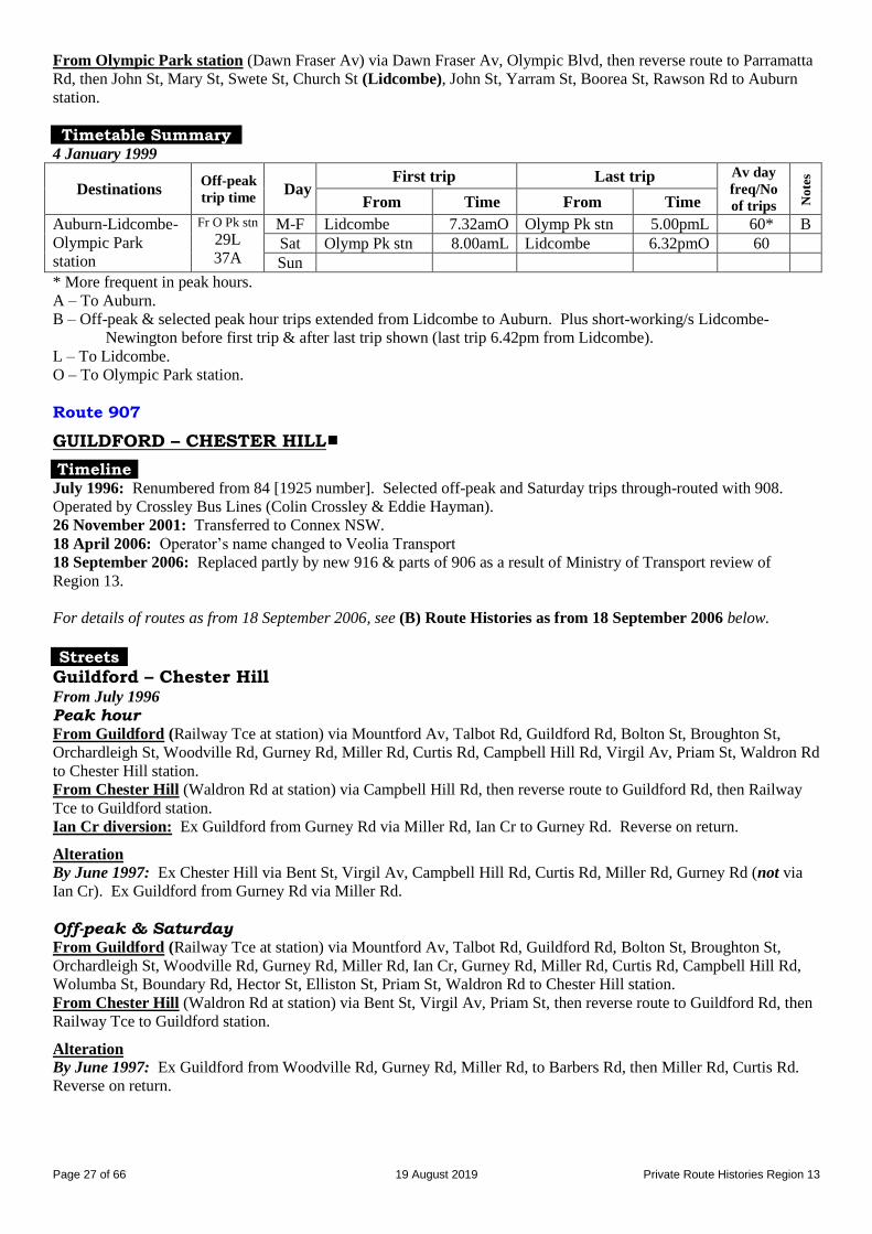
Page 27 of 66 19 August 2019 Private Route Histories Region 13
From Olympic Park station (Dawn Fraser Av) via Dawn Fraser Av, Olympic Blvd, then reverse route to Parramatta
Rd, then John St, Mary St, Swete St, Church St (Lidcombe), John St, Yarram St, Boorea St, Rawson Rd to Auburn
station.
Timetable Summary 4 January 1999
Destinations Off-peak
trip time Day
First trip Last trip Av day
freq/No
of trips No
tes
From Time From Time
Auburn-Lidcombe-
Olympic Park
station
Fr O Pk stn
29L
37A
M-F Lidcombe 7.32amO Olymp Pk stn 5.00pmL 60* B
Sat Olymp Pk stn 8.00amL Lidcombe 6.32pmO 60
Sun
* More frequent in peak hours. A – To Auburn.
B – Off-peak & selected peak hour trips extended from Lidcombe to Auburn. Plus short-working/s Lidcombe-
Newington before first trip & after last trip shown (last trip 6.42pm from Lidcombe).
L – To Lidcombe.
O – To Olympic Park station.
Route 907
GUILDFORD – CHESTER HILL
Timeline July 1996: Renumbered from 84 [1925 number]. Selected off-peak and Saturday trips through-routed with 908.
Operated by Crossley Bus Lines (Colin Crossley & Eddie Hayman).
26 November 2001: Transferred to Connex NSW.
18 April 2006: Operator’s name changed to Veolia Transport
18 September 2006: Replaced partly by new 916 & parts of 906 as a result of Ministry of Transport review of
Region 13.
For details of routes as from 18 September 2006, see (B) Route Histories as from 18 September 2006 below.
Streets
Guildford – Chester Hill From July 1996
Peak hour From Guildford (Railway Tce at station) via Mountford Av, Talbot Rd, Guildford Rd, Bolton St, Broughton St,
Orchardleigh St, Woodville Rd, Gurney Rd, Miller Rd, Curtis Rd, Campbell Hill Rd, Virgil Av, Priam St, Waldron Rd
to Chester Hill station.
From Chester Hill (Waldron Rd at station) via Campbell Hill Rd, then reverse route to Guildford Rd, then Railway
Tce to Guildford station.
Ian Cr diversion: Ex Guildford from Gurney Rd via Miller Rd, Ian Cr to Gurney Rd. Reverse on return.
Alteration
By June 1997: Ex Chester Hill via Bent St, Virgil Av, Campbell Hill Rd, Curtis Rd, Miller Rd, Gurney Rd (not via
Ian Cr). Ex Guildford from Gurney Rd via Miller Rd.
Off-peak & Saturday From Guildford (Railway Tce at station) via Mountford Av, Talbot Rd, Guildford Rd, Bolton St, Broughton St,
Orchardleigh St, Woodville Rd, Gurney Rd, Miller Rd, Ian Cr, Gurney Rd, Miller Rd, Curtis Rd, Campbell Hill Rd,
Wolumba St, Boundary Rd, Hector St, Elliston St, Priam St, Waldron Rd to Chester Hill station.
From Chester Hill (Waldron Rd at station) via Bent St, Virgil Av, Priam St, then reverse route to Guildford Rd, then
Railway Tce to Guildford station.
Alteration
By June 1997: Ex Guildford from Woodville Rd, Gurney Rd, Miller Rd, to Barbers Rd, then Miller Rd, Curtis Rd.
Reverse on return.
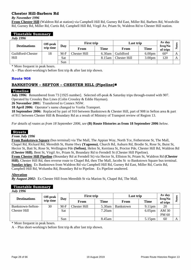
Page 28 of 66 19 August 2019 Private Route Histories Region 13
Chester Hill-Barbers Rd By November 1996
From Chester Hill (Waldron Rd at station) via Campbell Hill Rd, Gurney Rd East, Miller Rd, Barbers Rd, Woodville
Rd, Gurney Rd, Miller Rd, Curtis Rd, Campbell Hill Rd, Virgil Av, Priam St, Waldron Rd to Chester Hill station.
Timetable Summary July 1996
Destinations Off-peak
trip time Day
First trip Last trip Av day
freq/No
of trips No
tes
From Time From Time
Guildford-Chester
Hill
18 M-F Chester Hill 6.30am Guildford 6.00pm 60* A
Sat 8.15am Chester Hill 3.00pm 120 A
Sun
* More frequent in peak hours. A – Plus short-working/s before first trip & after last trip shown.
Route 908
BANKSTOWN – SEFTON – CHESTER HILL (Pipeline)
Timeline July 1996: Renumbered from 73 [1925 number]. Selected off-peak & Saturday trips through-routed with 907.
Operated by Crossley Bus Lines (Colin Crossley & Eddie Hayman).
26 November 2001: Transferred to Connex NSW.
18 April 2006: Operator’s name changed to Veolia Transport.
18 September 2006: Replaced by part of 910 between Bankstown & Chester Hill, part of 908 in Sefton area & part
of 911 between Chester Hill & Boundary Rd as a result of Ministry of Transport review of Region 13.
For details of routes as from 18 September 2006, see (B) Route Histories as from 18 September 2006 below.
Streets
From July 1996
From Bankstown Square (bus terminal) via The Mall, The Appian Way, North Tce, Fetherstone St, The Mall,
Chapel Rd, Rickard Rd, Meredith St, Hume Hwy (Yagoona), Church Rd, Auburn Rd, Brodie St, Rose St, Buist St,
Hector St, Batt St, Rose St, Wellington Pde (Sefton), Helen St, Kerrinea St, Proctor Pde, Chester Hill Rd, Waldron Rd
(Chester Hill), Bent St, Virgil Av, Priam St, Boundary Rd to Ferndell St (Chester Hill Pipeline).
From Chester Hill Pipeline (Boundary Rd at Ferndell St) via Hector St, Elliston St, Priam St, Waldron Rd (Chester
Hill), Chester Hill Rd, then reverse route to Chapel Rd, then The Mall, Jacobs St to Bankstown Square bus terminal.
Sunday trips: Ex Bankstown from Waldron Rd via Campbell Hill Rd, Gurney Rd East, Miller Rd, Curtis Rd,
Campbell Hill Rd, Wolumba Rd, Boundary Rd to Pipeline. Ex Pipeline unaltered.
Alteration
By August 2002: Ex Chester Hill from Meredith St via Marion St, Chapel Rd, The Mall.
Timetable Summary July 1996
Destinations Off-peak
trip time Day
First trip Last trip Av day
freq/No
of trips No
tes
From Time From Time
Bankstown-Sefton-
Chester Hill
30 M-F Chester Hill 5.30am Bankstown 9.11pm 20
Sat 7.20am 6.05pm AM 30
PM 60
Sun 8.45am 5.15pm 60 A
* More frequent in peak hours. A – Plus short-working/s before first trip & after last trip shown.
Page 29 of 66 19 August 2019 Private Route Histories Region 13
Route 910
PARRAMATTA – CHESTER HILL – BANKSTOWN via Clyde St Merrylands – Granville – South Granville (Sundays only)
General note: 320, the predecessor of 910, started life as a “Red Arrow” route with limited stops. However,
timetables suggest that it had become an “all stops” route by 1987. By the early 1990s, it was no longer regarded as
a “Red Arrow” route.
Timeline 29 July 1987:
Parramatta – Bankstown renumbered from 320 [Red Arrow number].
Operated jointly by Delwood Coaches & Auburn Bus Service (Stephen Todd).
Shared with 905 between Granville & Boundary Rd, South Granville until 1 August 1993.
9 October 1989: Auburn Bus Service transferred to Ian Barden & Associates.
25 July 1990: Auburn Bus Service transferred its half share to Delwood, leaving Delwood the sole owner, with
travelling restrictions between Chester Hill & Bankstown.
2 April 1992: Transferred to Baxter’s Bus Lines.
By 1 August 1993:
910 became sole route between Granville & South Granville via Clyde St.
Saturday afternoon trips ran Granville – South Granville (Boundary Rd), connecting at Boundary Rd with 73
Chester Hill – Bankstown.
Sunday trips ran Merrylands – Granville – South Granville (loop, out via Blaxcell St & return via Clyde St).
17 December 1995: Shortened to Parramatta – Chester Hill. 908 continued to run Bankstown – Chester Hill.
1 January 2005: Transferred to Connex NSW.
18 April 2006: Operator’s name changed to Veolia Transport.
18 September 2006: Replaced by parts of 908, new 910 (see 910 in (B) Route Histories as from 18 September 2006
below) & 911 as a result of Ministry of Transport review of Region 13.
For details of routes as from 18 September 2006, see (B) Route Histories as from 18 September 2006 below.
Streets
Parramatta – Chester Hill – Bankstown via Clyde St From 29 July 1987
From Parramatta (Argyle St at Westfield) via Argyle St, Marsden St, Market St, Church St, Phillip St, Smith St,
George St, Purchase St, Hassall St, Alfred St, Gray St, Good St, Cowper St, Bold St, Railway Pde, South St, Mary St,
Granville interchange, Railway Pde, South St, William St, Clyde St, Ferndell St, Boundary Rd (South Granville),
Hector St, Elliston St, Priam St, Waldron Rd (Chester Hill), Chester Hill Rd, Proctor Pde, Hector St, Buist St, Rose
St, Brodie St, Auburn Rd, Church Rd, Hume Hwy (Yagoona), Meredith St, Marion St, Chapel Rd, The Mall,
Bankstown Square bus terminal, The Mall, The Appian Way, North Tce to Bankstown station.
From Bankstown (North Tce at station) via Fetherston St, The Mall, Chapel Rd, Rickard Rd, Meredith St, then
reverse route to Waldron Rd (Chester Hill), then Bent St, Virgil Av, Priam St, Wolumba St, Boundary Rd (South
Granville), Ferndell St, Clyde St, William St, South St, Mary St, Granville interchange, Railway Pde, then reverse
route to Alfred St, then Hassall St, Parkes St, Wigram St, Hassall St, Station St, Darcy St, Church St, Argyle St to
Westfield (Parramatta).
Alterations
By 28 May 1990:
Ex Parramatta from George St into Hassall St. Ex Bankstown from Alfred St via Noller Pde, Purchase St,
Hassall St, Station St.
Ex Bankstown from Hume Hwy via Auburn Rd (not via Church Rd). Unaltered Ex Parramatta.
From 1 August 1993
From Parramatta (Argyle St at Westfield) via Argyle St, Marsden St, George St, Smith St, Darcy St, Church St,
Parkes St, Wigram St, Una St, Harris St, Allen St, Good St, Cowper St, Bold St, Railway Pde, South St, Mary St,
Granville interchange, Railway Pde, Memorial Dr, Clyde St, Ferndell St, Boundary Rd (South Granville), Hector St,
Waldron Rd (Chester Hill), Chester Hill Rd, Proctor Pde, Hector St, Buist St, Rose St, Brodie St, Auburn Rd, Hume
Hwy (Yagoona), St, Rickard Rd, Jacobs St, Bankstown Square bus terminal.
From Bankstown Square (bus terminal) via The Mall, The Appian Way, North Tce, Fetherstone St, The Mall,
Chapel Rd, Rickard Rd, then reverse route to Granville interchange, then Railway Pde, then reverse route to Parkes
St, then Station St, Darcy St, Church St, Argyle St to Westfield (Parramatta).
Page 30 of 66 19 August 2019 Private Route Histories Region 13
Parramatta – Chester Hill via Clyde St From 17 December 1995
From Parramatta (Argyle St at Westfield) via Argyle St, Marsden St, George St, Smith St, Darcy St, Church St,
Parramatta Rd, Good St, Cowper St, Bold St, Railway Pde, South St, Mary St, Granville interchange, Railway Pde,
Memorial Dr, Clyde St, Ferndell St, Boundary Rd (South Granville), Hector St, Elliston St, Priam St, Waldron Rd to
Chester Hill station.
From Chester Hill (Waldron Rd at station) via Bent St, Virgil Av, Priam St, then reverse route to Granville
interchange, then Railway Pde, Bold St, Parramatta Rd, Church St, Argyle St to Westfield (Parramatta).
Alterations
By 4 January 1999: Ex Parramatta from Parramatta Rd via Bold St. Ex Chester Hill unaltered.
By July 2002: Ex Parramatta from Hector St via Elliston St, Priam St, Waldron Rd. Reverse on return.
From 19 February 2006 (opening of new Parramatta interchange): Parramatta terminus at new interchange
(Argyle St). ? route to approach and leave Parramatta.
Timetable Summary 29 July 1987
Destinations Off-peak
trip time Day
First trip Last trip Av day
freq/No
of trips No
tes
From Time From Time
Parramatta-Chester
Hill-Bankstown
50 M-F Bankstown 7.49am Parramatta 5.03pm 60
Sat
Sun
14 December 1988
Destinations Off-peak
trip time Day
First trip Last trip Av day
freq/No
of trips No
tes
From Time From Time
Parramatta-Chester
Hill-Bankstown
55 M-F Bankstown 6.00am Parramatta 7.30pm 60
Sat 8.00am 1.30pm 60
Sun
1 August 1993
Destinations Off-peak
trip time Day
First trip Last trip Av day
freq/No
of trips No
tes
From Time From Time
Parramatta-Chester
Hill-Bankstown
46PB
12GS
M-F Bankstown 6.48amP Bankstown 5.50pmP 60* A
Sat Parramatta 7.10amB Parramatta 1.05pmB 60 C
Bankstown 6.35pmG
Sun
* More frequent in peak hours. A – Plus short-working/s before first trip & after last trip shown (last trip 8.32pm from South Granville to Granville).
B – To Bankstown.
C – Service between Chester Hill & Bankstown provided by 73 (change buses at Boundary Rd).
G – To Granville.
GS – From Granville to South Granville.
P – To Parramatta.
PB – From Parramatta to Bankstown.

Page 31 of 66 19 August 2019 Private Route Histories Region 13
17 December 1995
Destinations Off-peak
trip time Day
First trip Last trip Av day
freq/No
of trips No
tes
From Time From Time
Parramatta-Chester
Hill
30 M-F Chester Hill 6.29amP Parramatta 5.05pmC A
Granville 9.47pmS
Sat Parramatta 9.00amC Chester Hill 4.30pmP 60 B
Granville 7.43pmS
Sun Sth Granville 9.25amP Parramatta 5.26pmS 60 D
A – Day, Granville-South Granville 30, Parramatta-Chester Hill 60. Plus short-working/s before first shown.
Includes on-demand trips from Granville at night. Connections required at Granville on selected trips.
B – Plus short-working/s before first trip shown.
C – To Chester Hill.
D – Connections required on selected trips at Granville. Plus on-demand trips from Granville at night (last trip
7.13pm from Granville).
P – To Parramatta.
S – To South Granville.
Route 915
LIDCOMBE – CUMBERLAND COLLEGE [now University of Sydney, Cumberland campus]
Timeline 1 February 1990: Unnumbered route given number in Sydney Region Route Number System & transferred from
Westlink to E Street Bus Lines (Bob Taylor). Shared route with 920 from 26 September 1996.
Mid February 1991: Transferred to Crossley Bus lines.
29 January 1997: Transferred to Westway Bus & Coach Service (Threlkeld family).
7 July 2003: Operator’s name changed to Transit First.
For details of Route 915 as from 18 September 2006, see (B) Route Histories as from 18 September 2006 below.
Streets
Timetables prior to 1993 did not specify the route, but it is unlikely to have varied much over the years of operation.
From January 1993
From Lidcombe (Mark St ? at station) via Railway St, East St to within grounds of Cumberland College.
From Cumberland College via East St, Davey St, Marsden St, Mark St (?) to Lidcombe station.
By December 1997
From Lidcombe (Railway St at station) via Railway St, East St to within grounds of Cumberland College.
From Cumberland College via East St, Victoria St, Joseph St, Bridge St, Tooheys Lane, Railway St to Lidcombe
station.
Timetable Summary May 1990
Destinations Off-peak
trip time Day
First trip Last trip Av day
freq/No
of trips No
tes
From Time From Time
Lidcombe-
Cumberland
College (semester)
5 M-F Lidcombe 7.15am Cumb college 6.00pm 20* A
Sat
Sun
Lidcombe-
Cumberland
College (vacation)
5 M-F Lidcombe 7.50am Cumb college 5.25pm Ph
Sat
Sun
* More frequent in peak hours. A – Extra trips Mondays-Thursdays.
Ph – Peak hours only.
Page 32 of 66 19 August 2019 Private Route Histories Region 13
10 June 2000
Destinations Off-peak
trip time Day
First trip Last trip Av day
freq/No
of trips No
tes
From Time From Time
Lidcombe-Uni of
Sydney, Cumb’land
campus
5 M-F Lidcombe 7.15am Cumb campus 6.07pm 15* A Sat A Sun
* More frequent in peak hours during semester.
A – 920 also provided service Mondays-Saturdays.
Route 916
AUBURN – SOUTH GRANVILLE (Blaxcell St)
Timeline 31 July 1985: Renumbered from 239 [1925 number]. Operated by Auburn Passenger Transport (part of the Highway
Tours group – JD (Jim) Hill).
1987: Transferred to Crossley Bus Lines.
December 1988: Transferred to Westlink (partnership of four business men, later reduced to two, who were John
Clisdale & Hector Castrow).
25 July 1990: Transferred to Crossley Bus Lines (Colin Crossley & Eddie Hayman).
29 January 1997: Transferred to Westway Bus & Coach Service (Threlkeld family).
14 December 1997: Rerouted via Park, Chiswick & Chisholm Rds, replacing part of 918, as part of reorganisation of
916-9.
7 July 2003: Operator’s name changed to Transit First.
27 July 2003: Replaced by rerouting of 917 in a general reorganisation of 916-920. Streets
From 31 July 1985
From Auburn (South Pde at station) via Park Rd, Normanby Rd, Cumberland Rd, Sheffield St, Chisholm Rd, Mona
St, Clyde St, Redfern St, Blaxcell St to Hudson St (South Granville).
From South Granville (Blaxcell St at Hudson St) via Hudson St, Clyde St, then reverse route to Normanby St, then
Queen St, Auburn Rd, South Pde to Auburn station.
From 14 December 1997
From Auburn (South Pde at station) via Auburn Rd, Mary St, Park Rd, Chiswick Rd, Chisholm Rd, Mona St, Clyde
St, Redfern St, Blaxcell St to Hudson St (South Granville).
From South Granville (Blaxcell St at Hudson St) via Hudson St, Clyde St, then reverse route to Park Rd, then South
Pde to Auburn station.
Timetable Summary 31 July 1985
Destinations Off-peak
trip time Day
First trip Last trip Av day
freq/No
of trips No
tes
From Time From Time
Auburn-South
Granville
10 M-F Auburn 6.06am Sth Granville 5.45pm 60*
Sat 8.33am 12.42pm 60
Sun
* More frequent in peak hours.
14 December 1997
Destinations Off-peak
trip time Day
First trip Last trip Av day
freq/No
of trips No
tes
From Time From Time
Auburn-South
Granville
18 M-F Sth Granville 6.37am Auburn 6.20pm 60*
Sat Auburn 7.30am Sth Granville 2.47pm 60
Sun
* More frequent in peak hours.
Page 33 of 66 19 August 2019 Private Route Histories Region 13
Route 917
AUBURN – BERALA – GUILDFORD AUBURN – GUILDFORD via Park, Wellington & Chisholm Rds LIDCOMBE – REGENTS PARK – AUBURN – GUILDFORD
Timeline 31 July 1985: Lidcombe – Regents Park – Auburn – Guildford renumbered from an amalgamation of 5, 116, 123 &
149 [1925 numbers]. Service provided by extended 920 on Sundays. Operated by Auburn Passenger Transport (part
of the Highway Tours group – JD (Jim) Hill).
1987: Transferred to Crossley Bus Lines.
December 1988: Transferred to Westlink (partnership of four business men, later reduced to two, who were John
Clisdale & Hector Castrow).
25 July 1990: Transferred to Crossley Bus Lines (Colin Crossley & Eddie Hayman).
January 1993: Altered to Auburn – Berala – Guildford in a reorganisation of 917 & 918. Lidcombe – Berala –
Regents Park replaced by extension of 921.
29 January 1997: Transferred to Westway Bus & Coach Service (Threlkeld family).
14 December 1997: Late Saturday afternoon & all-day Sunday services on part of route provided by combined
919/920 (later 918/919) (Link bus).
7 July 2003: Operator’s name changed to Transit First.
28 July 2003: Rerouted as Auburn – Guildford via Park, Wellington & Chisholm Rds, replacing 916, in a general
reorganisation of 916-920. Link bus ceased.
18 September 2006: Replaced by part of 911 as a result of Ministry of Transport review of Region 13.
For details of routes as from 18 September 2006, see (B) Route Histories as from 18 September 2006 below.
Streets
Lidcombe – Berala – Auburn – Guildford From 31 July 1985
From Lidcombe (Railway St at station) via Joseph St, Kerrs Rd, Brixton Rd, Hyde Park Rd, Nottinghill Rd, Kibo Rd,
Fourth Av, Walters Rd, Kingsland Rd, Amy St (Regents Park), Park Rd, Lidbury St, Elizabeth St, Woodburn Rd
(Berala), Tilba St, Graham St, Water St, Cockthorpe Rd, Norval St (Auburn Hospital), Auburn Rd, South Pde
(Auburn), Park Rd, Queen St, Normanby Rd, Cumberland Rd, Northcote St, Chisholm Rd, Wellington Rd, Clyde St,
Chiswick Rd, Blaxcell St, Guildford Rd, Robertson St, Rawson Rd (South Granville), Excelsior St, Guildford Rd,
Railway Tce to Guildford station.
From Guildford (Railway Tce at station) via Mountford Av, Talbot Rd, Guildford Rd, then reverse route to Tilba St,
then The Crescent, Crawford St, Woodburn Rd, then reverse route to Kerrs Rd, then Joseph St, James St, Mark St,
Railway St to Lidcombe station.
Alteration
By 12 March 1986: Ex Guildford from Tilba St via Woodburn Rd (not via The Crescent, Crawford St). Ex
Lidcombe unaltered.
Auburn – Berala – Guildford From January 1993
From Auburn (South Pde at station) via Park Rd, Queen St, Auburn Rd, Norval St, Cockthorpe Rd, Water St,
Graham St, Tilba St, Woodburn Rd (Berala), Elizabeth St, Lidbury St, Park Rd, Wellington Rd, Clyde St, Chiswick
Rd, Blaxcell St, Guildford Rd, Robertson St, Rawson Rd (South Granville), Excelsior St, Guildford Rd, Railway Tce
to Guildford station.
From Guildford (Railway Tce at station) via Mountford Av, Talbot Rd, Guildford Rd, then reverse route to Auburn
Rd, then South Pde to Auburn station.
Alterations
By 1997: To depart from Auburn (railway side of South Pde) via Auburn Rd.
From 14 December 1997: Ex Auburn from Cockthorpe Rd via Woodburn Rd, Vaughan St, Graham St.
Reverse on return.
Auburn – Guildford via Park, Wellington & Chisholm Rds Alteration
From 28 July 2003: From Auburn via South Pde, Auburn Rd, Mary St, Park Rd, Wellington Rd, Chisholm Rd, Mona
St, Clyde St. Reverse on return.

Page 34 of 66 19 August 2019 Private Route Histories Region 13
Timetable Summary 31 July 1985
Destinations Off-peak
trip time Day
First trip Last trip Av day
freq/No
of trips No
tes
From Time From Time
Lidcombe-Berala-
Auburn-Guildford
Fr Guild
21A
36B
55L
M-F Berala 6.10amG Guildford 4.15pmL
5.35pmB
60* C
Guildford 8.43amL
Sat Berala 8.17amA 1.02pmB 60 D
Auburn 8.23amG
Sun E
* More frequent in peak hours. A – To Auburn.
B – To Berala.
C – Plus short-working/s before first trip & after last trip shown.
D – Eastwards ran Guildford-Auburn-Berala. Westwards ran separately Berala-Auburn & Auburn-Guildford.
E – Service over part of route provided by 920.
G – To Guildford.
L – To Lidcombe.
January 1993
Destinations Off-peak
trip time Day
First trip Last trip Av day
freq/No
of trips No
tes
From Time From Time
Auburn-Berala-
Guildford
27 M-F Guildford 6.17am Auburn 6.15pm 60* A
Sat Auburn 8.30am Guildford 3.30pm 60 B
Sun
* More frequent in peak hours. A – Plus short-working/s before first trip & after last trip shown.
B – Plus short-working/s before first trip shown.
Route 918
AUBURN – SOUTH AUBURN – AUBURN (bidirectional loop via Chisholm & Cumberland Rds)
AUBURN – SOUTH AUBURN via Cumberland Rd
Timeline 31 July 1985: Auburn – South Auburn via Cumberland Rd renumbered from 14 [1925 number]. Service provided by
combined 918/919 on weeknights & extended 920 on Sundays. Operated by Auburn Passenger Transport (part of the
Highway Tours group – JD (Jim) Hill).
1987: Transferred to Crossley Bus Lines.
December 1988: Transferred to Westlink (partnership of four business men, later reduced to two, who were John
Clisdale & Hector Castrow).
25 July 1990: Transferred to Crossley Bus Lines (Colin Crossley & Eddie Hayman).
By January 1993: Altered to Auburn – South Auburn – Auburn loop (mornings out via Chisholm Rd, return via
Cumberland Rd; afternoons the reverse) in a reorganisation of 917 & 918.
By July 1996: Weeknight service replaced by diversion of 919.
29 January 1997: Transferred to Westway Bus & Coach Service (Threlkeld family).
14 December 1997: Replaced by rerouting of 916 & 919 in a reorganisation of 916-9. Streets
Auburn – South Auburn via Cumberland Rd From 31 July 1985
From Auburn (South Pde at station) via Alice St, Northcote St, Cumberland Rd, Albert Rd, St Johns Rd (South
Auburn), Cumberland Rd, Northcote St, Alice St, Mary St, Auburn Rd, South Pde to Auburn station.

Page 35 of 66 19 August 2019 Private Route Histories Region 13
Auburn – South Auburn – Auburn (bidirectional loop via Chisholm & Cumberland Rds)
From January 1993
Anti-clockwise (mostly morning) From Auburn (South Pde at station) via Park Rd, Queen St, Auburn Rd, Mary St, Alice St, Northcote St, Chisholm
Rd, St Johns Rd (South Auburn), Cumberland Rd, Northcote St, Alice St, Mary St, Auburn Rd, South Pde to Auburn
station.
Clockwise (mostly afternoon) From Auburn (South Pde at station) via Park Rd, Queen St, Auburn Rd, Mary St, Alice St, Northcote St,
Cumberland Rd, St Johns Rd (South Auburn), Chisholm Rd, Northcote St, Alice St, Mary St, Auburn Rd, South Pde
to Auburn station.
Alteration
By 1997: To depart from Auburn (railway side of South Pde) via Auburn Rd.
Timetable Summary
31 July 1985
Destinations Off-peak
trip time Day
First trip Last trip Av day
freq/No
of trips No
tes
From Time From Time
Auburn-South
Auburn via
Cumberland Rd
12 M-F Sth Auburn 5.34am Auburn 9.05pm 30* A
Sat 8.07am Sth Auburn 5.15pm 60
Sun 9.30am Auburn 5.25pm 80 B
* More frequent in peak hours.
A – Includes combined 918/919 at night. B – Part of 920.
January 1993
Destinations Off-peak
trip time Day
First trip Last trip Av day
freq/No
of trips No
tes
From Time From Time
Auburn-Sth Auburn
via Cumberland &
Chisholm Rds
25
round
trip
M-F Auburn 5.27am Auburn 9.07pm 30* A
Sat Sth Auburn 7.55am Sth Auburn 5.22pm 60
Sun 8.40am Auburn 5.25pm 90 B
* More frequent in peak hours. A – Morning, clockwise. Afternoon, anti-clockwise. Includes combined 918/919 at night.
B – Combined 918/919.
Route 918
AUBURN – REGENTS PARK – LIDCOMBE – AUBURN (bidirectional loop)
28 July 2003: Replaced parts of 917, 919 & 920, as a large bidirectional loop in a general reorganisation of 916-920.
Operated by Transit First (Thelkeld family). Combined 918/919 ran on Sundays.
18 September 2006: Ceased but partly replaced by part of 909, as a result of Ministry of Transport review of Region
13.
For details of routes as from 18 September 2006, see (B) Route Histories as from 18 September 2006 below.
Streets
From 28 July 2003
Clockwise From Auburn (South Pde at station) via Auburn Rd, Norval St, Cockthorpe Rd, Woodburn Rd, Vaughan St, Joseph
St, Bridge St, Tooheys Lane, Railway St (Lidcombe), Mark St, James St, Joseph St, Georges Av, East St, Weeroona
Rd, Amy St (Regents Park), Park Rd, Mt Auburn Rd, Graham St, Vaughan St, Woodburn Rd, Cockthorpe Rd,
Norval St, Auburn Rd, Mary St, Park Rd, South Pde to Auburn station.
Anti-clockwise
From Auburn (South Pde at station) via Auburn Rd, Norval St, Cockthorpe Rd, Woodburn Rd, Vaughan St, Graham
St, Mt Auburn Rd, Park Rd, Amy St (Regents Park), Weeroona Rd, East St, Georges Av, Joseph St, Bridge St,
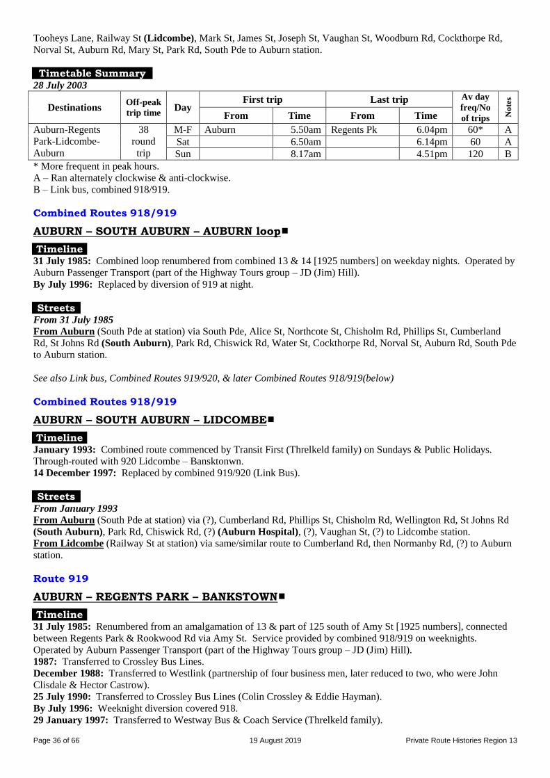
Page 36 of 66 19 August 2019 Private Route Histories Region 13
Tooheys Lane, Railway St (Lidcombe), Mark St, James St, Joseph St, Vaughan St, Woodburn Rd, Cockthorpe Rd,
Norval St, Auburn Rd, Mary St, Park Rd, South Pde to Auburn station.
Timetable Summary 28 July 2003
Destinations Off-peak
trip time Day
First trip Last trip Av day
freq/No
of trips No
tes
From Time From Time
Auburn-Regents
Park-Lidcombe-
Auburn
38
round
trip
M-F Auburn 5.50am Regents Pk 6.04pm 60* A
Sat 6.50am 6.14pm 60 A
Sun 8.17am 4.51pm 120 B
* More frequent in peak hours.
A – Ran alternately clockwise & anti-clockwise. B – Link bus, combined 918/919.
Combined Routes 918/919
AUBURN – SOUTH AUBURN – AUBURN loop
Timeline 31 July 1985: Combined loop renumbered from combined 13 & 14 [1925 numbers] on weekday nights. Operated by
Auburn Passenger Transport (part of the Highway Tours group – JD (Jim) Hill).
By July 1996: Replaced by diversion of 919 at night.
Streets From 31 July 1985
From Auburn (South Pde at station) via South Pde, Alice St, Northcote St, Chisholm Rd, Phillips St, Cumberland
Rd, St Johns Rd (South Auburn), Park Rd, Chiswick Rd, Water St, Cockthorpe Rd, Norval St, Auburn Rd, South Pde
to Auburn station.
See also Link bus, Combined Routes 919/920, & later Combined Routes 918/919(below)
Combined Routes 918/919
AUBURN – SOUTH AUBURN – LIDCOMBE
Timeline January 1993: Combined route commenced by Transit First (Threlkeld family) on Sundays & Public Holidays.
Through-routed with 920 Lidcombe – Bansktonwn.
14 December 1997: Replaced by combined 919/920 (Link Bus).
Streets From January 1993
From Auburn (South Pde at station) via (?), Cumberland Rd, Phillips St, Chisholm Rd, Wellington Rd, St Johns Rd
(South Auburn), Park Rd, Chiswick Rd, (?) (Auburn Hospital), (?), Vaughan St, (?) to Lidcombe station.
From Lidcombe (Railway St at station) via same/similar route to Cumberland Rd, then Normanby Rd, (?) to Auburn
station.
Route 919
AUBURN – REGENTS PARK – BANKSTOWN
Timeline 31 July 1985: Renumbered from an amalgamation of 13 & part of 125 south of Amy St [1925 numbers], connected
between Regents Park & Rookwood Rd via Amy St. Service provided by combined 918/919 on weeknights.
Operated by Auburn Passenger Transport (part of the Highway Tours group – JD (Jim) Hill).
1987: Transferred to Crossley Bus Lines.
December 1988: Transferred to Westlink (partnership of four business men, later reduced to two, who were John
Clisdale & Hector Castrow).
25 July 1990: Transferred to Crossley Bus Lines (Colin Crossley & Eddie Hayman).
By July 1996: Weeknight diversion covered 918.
29 January 1997: Transferred to Westway Bus & Coach Service (Threlkeld family).

Page 37 of 66 19 August 2019 Private Route Histories Region 13
14 December 1997:
Rerouted via Cumberland, Albert, Chisholm & St Johns Rds, replacing part of 918 in a reorganisation of 916-
919.
Late Saturday afternoon & all-day Sunday services provided by Link bus, combined 919/920.
7 July 2003: Operator’s name changed to Transit First
28 July 2003:
Rerouted in Berala & Regents Park, replacing parts of 917 & 920.
Rerouted via Potts Hill, replacing ceased 920 in a general reorganisation of 916-920.
Link bus ceased, but combined 918/919 ran on Sundays.
18 September 2006: Partly replaced by parts of 908 & 909 as a result of Ministry of Transport review of Region 13.
For details of routes as from 18 September 2006, see (B) Route Histories as from 18 September 2006 below.
Streets
From 31 July 1985
From Auburn (South Pde at station) via Auburn Rd, Beatrice St, Park Rd, Amy St (Regents Park), Joseph St,
Rookwood Rd, Chapel Rd, The Mall, Jacobs St, Bankstown Square bus terminal, The Mall, The Appian Way, North
Tce to Bankstown station.
From Bankstown (North Tce at station) via Fetherstone St, The Mall, Chapel Rd, then reverse route to Auburn Rd,
then Queen St, Park Rd, South Pde to Auburn station.
Alteration
By 14 November 1988: Ex Auburn from Chapel Rd via Rickard Rd, Jacobs St, Bankstown Square bus terminal.
From 14 December 1997
From Auburn (South Pde at station) via Auburn Rd, Mary St, Park Rd, Queen St, Normanby Rd, Cumberland Rd,
Albert Rd, Chisholm Rd, St Johns Rd, Park Rd, Amy St (Regents Park), Joseph St, Rookwood Rd, Chapel Rd,
Rickard Rd, Jacobs St, Bankstown Square bus terminal, The Mall, The Appian Way, North Tce to Bankstown station.
From Bankstown (North Tce at station) via Fetherstone St, The Mall, Chapel Rd, then reverse route to Park Rd, then
South Pde to Auburn station.
Kibo Rd diversion: From Amy St via Kingsland Rd, Walters Rd, Fourth Av, Kibo Rd, Kingsland Rd to Amy St
(direction of loop?).
From 28 July 2003
From Auburn (South Pde at station) via Auburn Rd, Mary St, Cumberland Rd, Albert Rd, Chisholm Rd, St Johns Rd,
Lidbury St, Woodburn Rd (Berala), Kerrs Rd, Nottinghill Rd, Walters Rd, Kingsland Rd, Amy St (Regents Park),
Joseph St, Rookwood Rd, Brunker Rd, Powell St, McMillan St, Ashby Av, Woodbine St (Potts Hill), Avoca St,
George St, Rookwood Rd, Chapel Rd, Rickard Rd, Jacobs St, Bankstown Square bus terminal, The Mall, The Appian
Way, North Tce to Bankstown station.
From Bankstown (North Tce at station) via Fetherstone St, The Mall, Chapel Rd, then reverse route to Mary St, then
Park Rd, South Pde to Auburn station.
Trips not via Potts Hill: Direct via Rookwood Rd (not via Potts Hill).
Timetable Summary 31 July 1985
See also 920
Destinations Off-peak
trip time Day
First trip Last trip Av day
freq/No
of trips No
tes
From Time From Time
Auburn-Regents
Park-Bankstown
27 M-F Auburn 6.28am Auburn 5.27pmB
9.05pmS
60* A
Sat 8.35am Bankstown 4.05pm 60 A
Sun Sth Auburn 9.28am Auburn 5.25pm 6 trips C
* More frequent in peak hours. A – Plus short-working/s before first trip & after last trip shown.
B – To Bankstown.
C – Service provided by extended 920.
S – To South Auburn
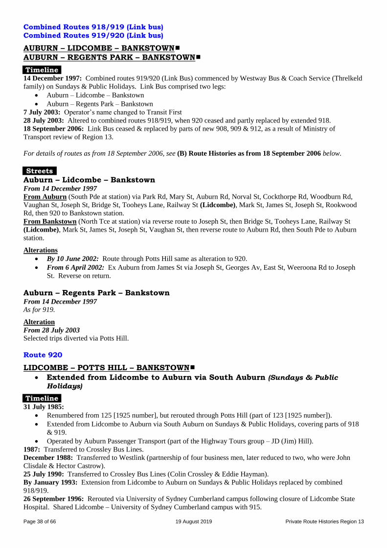
Page 38 of 66 19 August 2019 Private Route Histories Region 13
Combined Routes 918/919 (Link bus) Combined Routes 919/920 (Link bus)
AUBURN – LIDCOMBE – BANKSTOWN
AUBURN – REGENTS PARK – BANKSTOWN
Timeline 14 December 1997: Combined routes 919/920 (Link Bus) commenced by Westway Bus & Coach Service (Threlkeld
family) on Sundays & Public Holidays. Link Bus comprised two legs:
Auburn – Lidcombe – Bankstown
Auburn – Regents Park – Bankstown
7 July 2003: Operator’s name changed to Transit First
28 July 2003: Altered to combined routes 918/919, when 920 ceased and partly replaced by extended 918.
18 September 2006: Link Bus ceased & replaced by parts of new 908, 909 & 912, as a result of Ministry of
Transport review of Region 13.
For details of routes as from 18 September 2006, see (B) Route Histories as from 18 September 2006 below.
Streets
Auburn – Lidcombe – Bankstown From 14 December 1997
From Auburn (South Pde at station) via Park Rd, Mary St, Auburn Rd, Norval St, Cockthorpe Rd, Woodburn Rd,
Vaughan St, Joseph St, Bridge St, Tooheys Lane, Railway St (Lidcombe), Mark St, James St, Joseph St, Rookwood
Rd, then 920 to Bankstown station.
From Bankstown (North Tce at station) via reverse route to Joseph St, then Bridge St, Tooheys Lane, Railway St
(Lidcombe), Mark St, James St, Joseph St, Vaughan St, then reverse route to Auburn Rd, then South Pde to Auburn
station.
Alterations
By 10 June 2002: Route through Potts Hill same as alteration to 920.
From 6 April 2002: Ex Auburn from James St via Joseph St, Georges Av, East St, Weeroona Rd to Joseph
St. Reverse on return.
Auburn – Regents Park – Bankstown From 14 December 1997
As for 919.
Alteration
From 28 July 2003
Selected trips diverted via Potts Hill.
Route 920
LIDCOMBE – POTTS HILL – BANKSTOWN
Extended from Lidcombe to Auburn via South Auburn (Sundays & Public
Holidays)
Timeline 31 July 1985:
Renumbered from 125 [1925 number], but rerouted through Potts Hill (part of 123 [1925 number]).
Extended from Lidcombe to Auburn via South Auburn on Sundays & Public Holidays, covering parts of 918
& 919.
Operated by Auburn Passenger Transport (part of the Highway Tours group – JD (Jim) Hill).
1987: Transferred to Crossley Bus Lines.
December 1988: Transferred to Westlink (partnership of four business men, later reduced to two, who were John
Clisdale & Hector Castrow).
25 July 1990: Transferred to Crossley Bus Lines (Colin Crossley & Eddie Hayman).
By January 1993: Extension from Lidcombe to Auburn on Sundays & Public Holidays replaced by combined
918/919.
26 September 1996: Rerouted via University of Sydney Cumberland campus following closure of Lidcombe State
Hospital. Shared Lidcombe – University of Sydney Cumberland campus with 915.

Page 39 of 66 19 August 2019 Private Route Histories Region 13
29 January 1997: Transferred to Westway Bus & Coach Service (Threlkeld family).
14 December 1997: Late Saturday afternoon & all-day Sunday services provided by Link bus, combined routes
919/920.
7 July 2003: Operator’s name changed to Transit First
27 July 2003: Ceased. Partly replaced in general reorganisation by parts of 918 & 919.
General note: 912 commenced running over a very similar route from 18 September 2006.
Streets
From 31 July 1985
From Lidcombe (Railway St at station) via Joseph St, Rookwood Rd, Lidcombe Hospital internal roads, Brunker Rd,
Powell St, McMillan St, Ashby Av, Woodbine St (Potts Hill), Avoca St, George St, The Boulevarde, Meredith St,
French Av, Chapel Rd, The Mall, Bankstown Square bus terminal, The Mall, The Appian Way, North Tce to
Bankstown station.
From Bankstown (North Tce at station) via Fetherstone St, The Mall, Chapel Rd, then reverse route to Joseph St,
then James St, Mark St, Railway St to Lidcombe station.
Sundays & Public Holidays route: Ex Lidcombe direct via Jospeh St (not via Lidcombe Hospital internal roads).
Extension from Lidcombe to Auburn (Sundays & Public Holidays): From Lidcombe station via Joseph St,
Vaughan St, Woodburn Rd, Cockthorpe Rd, Norval St, Auburn Rd, Chiswick Rd, Park Rd, St Johns Rd (South
Auburn), Cumberland Rd, Phillips St, Chisholm Rd, Northcote St, Alice St, Queen St, Auburn Rd, South Pde to
Auburn station. Return via Alice St, then reverse route to Vaughan St, then Joseph St, James St, Park St, Railway St
to Lidcombe station.
Alterations
From 26 September 1996 (weekdays & Saturdays): From Lidcombe station via Joseph St, Georges Av, East
St, Weeroona Rd, Joseph St. Return from Joseph St via James St, Mark St, Railway St to Lidcombe station.
From 26 September 1996 (Sundays & Public Holidays): Direct via Joseph St, Rookwood Rd.
By 14 December 1997: To approach Lidcombe from Joseph St via Bridge St, Tooheys Lane, Railway St.
From Lidcombe via Mark St, James St, Joseph St.
By 19 June 2000: Ex Lidcombe from George St via Rookwood Rd. Reverse on return.
Timetable Summary 31 July 1985
See also 919
Destinations Off-peak
trip time Day
First trip Last trip Av day
freq/No
of trips No
tes
From Time From Time
Lidcombe-Potts
Hill-Bankstown
25 M-F Lidcombe 5.50am Lidcombe 6.10pm 60*
Sat 8.07am 6.07pm 60
Sun Bankstown 9.00am Auburn 5.25pm 80 A
* More frequent in peak hours. A – Link bus, combined 919/920.
Route 921
LIDCOMBE – BERALA – REGENTS PARK – BANKSTOWN
Timeline 12 March 1986: Berala – Regents Park – Bankstown commenced by Auburn Passenger Transport (part of the
Highway Tours group – JD (Jim) Hill).
1987: Transferred to Crossley Bus Lines.
December 1988: Transferred to Westlink (partnership of four business men, later reduced to two, who were John
Clisdale & Hector Castrow).
25 July 1990: Transferred to Crossley Bus Lines (Colin Crossley & Eddie Hayman).
January 1993: Extended from Berala to Lidcombe, replacing part of 917.
29 January 1997: Transferred to Westway Bus & Coach Service (Threlkeld family).
By 14 December 1997: Rerouted through Potts Hill.
7 July 2003: Operator’s name changed to Transit First.
18 September 2006: Partly replaced by part of 909 as a result of Ministry of Transport review of Region 13.
For details of routes as from 18 September 2006, see (B) Route Histories as from 18 September 2006 below.
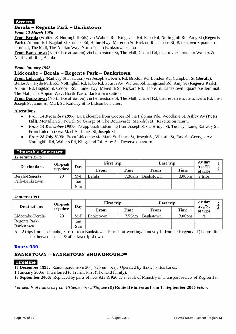
Page 40 of 66 19 August 2019 Private Route Histories Region 13
Streets
Berala – Regents Park – Bankstown From 12 March 1986
From Berala (Walters & Nottinghill Rds) via Walters Rd, Kingsland Rd, Kibo Rd, Nottinghill Rd, Amy St (Regents
Park), Auburn Rd, Bagdad St, Cooper Rd, Hume Hwy, Meredith St, Rickard Rd, Jacobs St, Bankstown Square bus
terminal, The Mall, The Appian Way, North Tce to Bankstown station.
From Bankstown (North Tce at station) via Fetherstone St, The Mall, Chapel Rd, then reverse route to Walters &
Nottinghill Rds, Berala.
From January 1993
Lidcombe – Berala – Regents Park – Bankstown From Lidcombe (Railway St at station) via Joseph St, Kerrs Rd, Brixton Rd, London Rd, Campbell St (Berala),
Burke Av, Hyde Park Rd, Nottinghill Rd, Kibo Rd, Fourth Av, Walters Rd, Kingsland Rd, Amy St (Regents Park),
Auburn Rd, Bagdad St, Cooper Rd, Hume Hwy, Meredith St, Rickard Rd, Jacobs St, Bankstown Square bus terminal,
The Mall, The Appian Way, North Tce to Bankstown station.
From Bankstown (North Tce at station) via Fetherstone St, The Mall, Chapel Rd, then reverse route to Kerrs Rd, then
Joseph St James St, Mark St, Railway St to Lidcombe station.
Alterations
From 14 December 1997: Ex Lidcombe from Cooper Rd via Palomar Pde, Woodbine St, Ashby Av (Potts
Hill), McMillan St, Powell St, George St, The Boulevarde, Meredith St. Reverse on return.
From 14 December 1997: To approach Lidcombe from Joseph St via Bridge St, Tooheys Lane, Railway St.
From Lidcombe via Mark St, James St, Joseph St.
From 28 July 2003: From Lidcombe via Mark St, James St, Joseph St, Victoria St, East St, Georges Av,
Nottinghill Rd, Walters Rd, Kingsland Rd, Amy St. Reverse on return.
Timetable Summary 12 March 1986
Destinations Off-peak
trip time Day
First trip Last trip Av day
freq/No
of trips No
tes
From Time From Time
Berala-Regents
Park-Bankstown
20 M-F Berala 7.30am Bankstown 3.00pm 2 trips
Sat
Sun
January 1993
Destinations Off-peak
trip time Day
First trip Last trip Av day
freq/No
of trips No
tes
From Time From Time
Lidcombe-Berala-
Regents Park-
Bankstown
28 M-F Bankstown 7.55am Bankstown 3.00pm A
Sat
Sun
A – 2 trips from Lidcombe, 3 trips from Bankstown. Plus short-working/s (mostly Lidcombe-Regents Pk) before first
trip, between peaks & after last trip shown.
Route 930
BANKSTOWN – BANKSTOWN SHOWGROUND
Timeline 17 December 1995: Renumbered from 20 [1925 number]. Operated by Baxter’s Bus Lines.
1 January 2005: Transferred to Transit First (Thelkeld family).
18 September 2006: Replaced by parts of new 925 & 926 as a result of Ministry of Transport review of Region 13.
For details of routes as from 18 September 2006, see (B) Route Histories as from 18 September 2006 below.
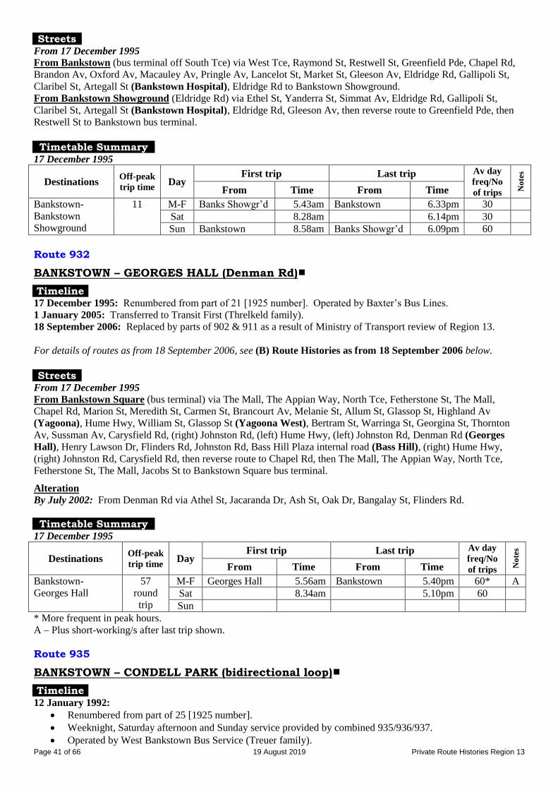
Page 41 of 66 19 August 2019 Private Route Histories Region 13
Streets From 17 December 1995
From Bankstown (bus terminal off South Tce) via West Tce, Raymond St, Restwell St, Greenfield Pde, Chapel Rd,
Brandon Av, Oxford Av, Macauley Av, Pringle Av, Lancelot St, Market St, Gleeson Av, Eldridge Rd, Gallipoli St,
Claribel St, Artegall St (Bankstown Hospital), Eldridge Rd to Bankstown Showground.
From Bankstown Showground (Eldridge Rd) via Ethel St, Yanderra St, Simmat Av, Eldridge Rd, Gallipoli St,
Claribel St, Artegall St (Bankstown Hospital), Eldridge Rd, Gleeson Av, then reverse route to Greenfield Pde, then
Restwell St to Bankstown bus terminal.
Timetable Summary
17 December 1995
Destinations Off-peak
trip time Day
First trip Last trip Av day
freq/No
of trips No
tes
From Time From Time
Bankstown-
Bankstown
Showground
11 M-F Banks Showgr’d 5.43am Bankstown 6.33pm 30
Sat 8.28am 6.14pm 30
Sun Bankstown 8.58am Banks Showgr’d 6.09pm 60
Route 932
BANKSTOWN – GEORGES HALL (Denman Rd)
Timeline 17 December 1995: Renumbered from part of 21 [1925 number]. Operated by Baxter’s Bus Lines.
1 January 2005: Transferred to Transit First (Threlkeld family).
18 September 2006: Replaced by parts of 902 & 911 as a result of Ministry of Transport review of Region 13.
For details of routes as from 18 September 2006, see (B) Route Histories as from 18 September 2006 below.
Streets
From 17 December 1995
From Bankstown Square (bus terminal) via The Mall, The Appian Way, North Tce, Fetherstone St, The Mall,
Chapel Rd, Marion St, Meredith St, Carmen St, Brancourt Av, Melanie St, Allum St, Glassop St, Highland Av
(Yagoona), Hume Hwy, William St, Glassop St (Yagoona West), Bertram St, Warringa St, Georgina St, Thornton
Av, Sussman Av, Carysfield Rd, (right) Johnston Rd, (left) Hume Hwy, (left) Johnston Rd, Denman Rd (Georges
Hall), Henry Lawson Dr, Flinders Rd, Johnston Rd, Bass Hill Plaza internal road (Bass Hill), (right) Hume Hwy,
(right) Johnston Rd, Carysfield Rd, then reverse route to Chapel Rd, then The Mall, The Appian Way, North Tce,
Fetherstone St, The Mall, Jacobs St to Bankstown Square bus terminal.
Alteration
By July 2002: From Denman Rd via Athel St, Jacaranda Dr, Ash St, Oak Dr, Bangalay St, Flinders Rd.
Timetable Summary 17 December 1995
Destinations Off-peak
trip time Day
First trip Last trip Av day
freq/No
of trips No
tes
From Time From Time
Bankstown-
Georges Hall
57
round
trip
M-F Georges Hall 5.56am Bankstown 5.40pm 60* A
Sat 8.34am 5.10pm 60
Sun
* More frequent in peak hours. A – Plus short-working/s after last trip shown.
Route 935
BANKSTOWN – CONDELL PARK (bidirectional loop)
Timeline 12 January 1992:
Renumbered from part of 25 [1925 number].
Weeknight, Saturday afternoon and Sunday service provided by combined 935/936/937.
Operated by West Bankstown Bus Service (Treuer family).
Page 42 of 66 19 August 2019 Private Route Histories Region 13
5 May 2003: Transferred to Westway Bus & Coach Service (Threlkeld family).
July 2003: Operator’s name changed to Transit First.
18 September 2006: As a result of Ministry of Transport review of Region 13, replaced by part of new 925, which
was allocated to Region 10.
For details of routes as from 18 September 2006, see (B) Route Histories as from 18 September 2006 below.
Streets
From 12 January 1992
Anti-clockwise (via Townsend St, then Yanderra St) From Bankstown Square (bus terminal) via The Mall, The Appian Way, North Tce, Fetherstone St, The Mall,
Chapel Rd, Marion St, Hunter St, Lancelot St, Simmat Av, Townsend St (Condell Park), Fourth Av, Yanderra St,
Edgar St, Augusta St, Cragg St, Lancelot St, Hunter St, Marion St, Chapel Rd, The Mall, Jacobs St to Bankstown
Square bus terminal.
Clockwise (via Yanderra St, then Townsend St) From Bankstown Square (bus terminal) via The Mall, The Appian Way, North Tce, Fetherstone St, The Mall,
Chapel Rd, Marion St, Hunter St, Lancelot St, Cragg St, Augusta St, Edgar St, Yanderra St, Fourth Av, Townsend St
(Condell Park), Simmat Av, Lancelot St, Hunter St, Marion St, Chapel Rd, The Mall, Jacobs St to Bankstown Square
bus terminal.
Timetable Summary
12 January 1992
Destinations Off-peak
trip time Day
First trip Last trip Av day
freq/No
of trips No
tes
From Time From Time
Bankstown-Condell
Park
25
round
trip
M-F Bankstown 5.33am Condell Pk 9.20pm 30 A
Sat 6.51am 6.19pm AM 30
PM 45
A
Sun 8.40am 5.22pm 11 trips A
A – On weekdays (other than at night) & Saturday mornings, trips generally ran alternately clockwise & anti-
clockwise. Includes combined loop 935/936/937 on weeknights, Saturday afternoons and all day Sunday.
Combined Routes 935/936/937
BANKSTOWN – CONDELL PARK – GEORGES HALL – YAGOONA WEST
Timeline 12 January 1992: Weeknight, Saturday afternoon and Sunday combined trips renumbered from part of 25 [1925
number]. Operated by West Bankstown Bus Service (Treuer family).
5 May 2003: Transferred to Westway Bus & Coach Service (Threlkeld family).
July 2003: Operator’s name changed to Transit First.
18 September 2006: As a result of Ministry of Transport review of Region 13, replaced by new routes 905, 911 &
925. From that time 925 was transferred to Region 10.
For details of routes as from 18 September 2006, see (B) Route Histories as from 18 September 2006 below.
Streets From 12 January 1992
From Bankstown Square (bus terminal) via The Mall, The Appian Way, North Tce, Fetherstone St, The Mall,
Chapel Rd, Marion St, Hunter St, Lancelot St, Edgar St, Augusta St, Edgar St, Yanderra St, Fourth Av, Manahan St
(Condell Park), Marion St, Owen Rd, Birdwood Rd, Georges Cr (Georges Hall), Rex Rd, Bambil St, Amaroo Av,
Ballina St, Rex Rd, Bellevue Av, Georgina St, Warringa Rd, Glassop St (Yagoona West), Colechin St, Cantrell St,
Waruda St, Edgar St, Marion St, Chapel Rd, The Mall, Jacobs St to Bankstown Square bus terminal.
Page 43 of 66 19 August 2019 Private Route Histories Region 13
Route 936
BANKSTOWN – YAGOONA WEST – GEORGES HALL (Rex Rd & Bambil St)
Timeline 12 January 1992:
Renumbered from part of 25 [1925 number].
Saturday morning service provided by combined 936/937.
Weeknight, Saturday afternoon and Sunday service provided by combined 935/936/937.
Operated by West Bankstown Bus Service (Treuer family).
5 May 2003: Transferred to Westway Bus & Coach Service (Threlkeld family).
July 2003: Operator’s name changed to Transit First.
18 September 2006: Replaced by part of 911 as a result of Ministry of Transport review of Region 13.
For details of routes as from 18 September 2006, see (B) Route Histories as from 18 September 2006 below.
Streets
From 12 January 1992
From Bankstown Square (bus terminal) via The Mall, The Appian Way, North Tce, Fetherstone St, The Mall,
Chapel Rd, Marion St, Edgar St, Waruda St, Saltash St, Glassop St (Yagoona West), Bertram St, Warringa Rd,
Georgina St, Bellevue Av, Rex Rd, Bambil St (Georges Hall), Amaroo Av, Ballina St, Rex Rd, then reverse route to
Glassop St, then Colechin St, Cantrell St, Waruda St, Edgar St, Marion St, Chapel Rd, The Mall, Jacobs St to
Bankstown Square bus terminal.
Timetable Summary 12 January 1992
Destinations Off-peak
trip time Day
First trip Last trip Av day
freq/No
of trips No
tes
From Time From Time
Bankstown-
Yagoona West-
Georges Hall
35
round
trip
M-F Georges Hall 5.30am Georges Hall 9.30pm 40* A
Sat Bankstown 6.40am 6.28pm 40 B
Sun 8.40am 5.31pm 35 A
* More frequent in peak hours. A – Includes combined 935/936/937 on weeknights & Sundays.
B – Includes combined 936/937 (morning) & combined 935/936/937 (afternoon).
Combined Routes 936/937
BANKSTOWN – GEORGES HALL – YAGOONA WEST
Timeline 12 January 1992: Saturday morning combined trips renumbered from part of 25 [1925 number]. Operated by West
Bankstown Bus Service (Treuer family).
5 May 2003: Transferred to Westway Bus & Coach Service (Threlkeld family).
July 2003: Operator’s name changed to Transit First.
18 September 2006: As a result of Ministry of Transport review of Region 13, replaced by trips on new routes 905 &
911.
For details of routes as from 18 September 2006, see (B) Route Histories as from 18 September 2006 below.
Streets From 12 January 1992
From Bankstown Square (bus terminal) via The Mall, The Appian Way, North Tce, Fetherstone St, The Mall,
Chapel Rd, Marion St, Owen Rd, Birdwood Rd, Georges Cr, Beale St, Henry Lawson Dr (Georges Hall), Haig Av,
Georges Cr, Rex Rd, Bambil St, Amaroo Av, Ballina St, Rex Rd, Bellevue Av, Georgina St, Warringa Rd, Glassop St
(Yagoona West), Colechin St, Cantrell St, Waruda St, Edgar St, Marion St, Chapel Rd, The Mall, Jacobs St to
Bankstown Square bus terminal.

Page 44 of 66 19 August 2019 Private Route Histories Region 13
Route 937
BANKSTOWN – GEORGES HALL (Henry Lawson Dr)
Timeline 12 January 1992:
Renumbered from part of 25 [1925 number].
Saturday morning service provided by combined 936/937.
Weeknight, Saturday afternoon & Sunday service provided by combined 935/936/937.
Operated by West Bankstown Bus Service (Treuer family).
5 May 2003: Transferred to Westway Bus & Coach Service (Threlkeld family).
July 2003: Operator’s name changed to Transit First.
18 September 2006: Replaced by part of 905 as a result of Ministry of Transport review of Region 13.
For details of routes as from 18 September 2006, see (B) Route Histories as from 18 September 2006 below.
Streets
From 12 January 1992
From Bankstown Square (bus terminal) via The Mall, The Appian Way, North Tce, Fetherstone St, The Mall,
Chapel Rd, Marion St, Owen Rd, Birdwood Rd, Georges Cr, Beale St, Henry Lawson Dr (Georges Hall), Haig Av,
Birdwood Rd, then reverse route to Chapel Rd, then The Mall, Jacobs St to Bankstown Square bus terminal.
Timetable Summary 12 January 1992
Destinations Off-peak
trip time Day
First trip Last trip Av day
freq/No
of trips No
tes
From Time From Time
Bankstown-
Georges Hall
35
round
trip
M-F Bankstown 5.49am Georges Hall 9.28pm 40* A
Sat 6.40am 6.26pm 40 B
Sun 8.40am 5.29pm 35 A
* More frequent in peak hours. A – Includes combined 935/936/937 on weeknights & Sundays.
B – Includes combined 936/937 (morning) & combined 935/936/937 (afternoon).
+ + + + + + + + +
(B) Route Histories as from 18 September 2006
Route 900
LIVERPOOL – BANKSTOWN – BURWOOD
Timeline 18 September 2006: 486 & 860 amalgamated as 900 and extended from Strathfield to Burwood, as a result of
Ministry of Transport review of Region 13. Shares part of route with 913 & 914. Operated by Transit First (Thelkeld
family).
1 February 2007: Transferred to Veolia Transport.
6 December 2010: Renumbered M90 as part of the introduction of the Government’s Metrobus network. First
privately operated route to be so classified.
Streets From 18 September 2006
From Liverpool (interchange) via Moore St, Bigge St, Campbell St, George St, Scott St, Newbridge Rd, Milperra Rd
(Milperra), Ashford Av, Bullecourt Av (University of Western Sydney, Bankstown campus), Horsley Rd, Amour
St, Marigold St, Milperra Rd, Canterbury Rd, Chapel Rd South, Brandon Av, Greenwood Av, Marion St, Chapel Rd,
The Mall, The Appian Way, North Tce (Bankstown), Fetherstone St, The Mall, Jacobs St, Bankstown Square bus
terminal, Jacobs St, Rickard Rd, Chapel Rd, Hume Hwy, Boronia Rd, Noble Rd, Cardigan Rd (Greenacre), Waterloo
Rd, Hume Hwy, The Boulevarde, Redmyre Rd, Raw Sq, Albert Rd (Strathfield), Churchill Av, Raw Sq, Redmyre
Rd, The Boulevarde, Morwick St, Railway Pde, Burwood Rd, Victoria St East to Burwood Westfield.
From Burwood (Burwood Rd at Westfield) via Burwood Rd, Railway Pde, Morwick St, The Boulevarde, Redmyre
Rd, Raw Sq, Albert Rd (Strathfield), Churchill Av, Raw Sq, Redmyre Rd, The Boulevarde, Hume Hwy, then reverse
route to Rickard Rd, then Jacobs St, Bankstown Square bus terminal, The Mall, The Appian Way, North Tce
Page 45 of 66 19 August 2019 Private Route Histories Region 13
(Bankstown), Fetherstone St, The Mall, Chapel Rd, Marion St, then reverse route to Newbridge Rd, then Bigge St,
Campbell St, George St, Moore St to Liverpool interchange.
Alteration
From 8 December 2008:
From Liverpool interchange via College St, Elizabeth St, Bigge St, Campbell St. To approach Liverpool from
Newbridge Rd via Bigge St, Elizabeth St, George St, Moore St to Liverpool interchange.
Ex Liverpool from Chapel Rd South via Macauley Av, Restwell St, South Tce (Bankstown), bus lane over
railway bridge, North Tce, Fetherstone St, The Mall, Bankstown Square bus terminal, Jacobs St, Rickard Rd.
Ex Burwood from Bankstown Square bus terminal via The Mall, The Appian Way, North Tce, bus lane over
railway bridge, South Tce, Restwell St, Macauley Av, Chapel Rd South.
Timetable Summary 18 September 2006
Destinations Off-peak
trip time Day
First trip Last trip Av day
freq/No
of trips No
tes
From Time From Time
Liverpool-
Bankstown-
Burwood
Fr Liv
46K
83S
94B
M-F Liverpool 5.15amS
6.30amB
Liverpool 7.15pmB 30* A
Sat 6.17amS
7.17amB
4.15pmB C
Burwood 7.35pmK
Sun Bankstown 8.31amB 6.35pmK 60 D
* More frequent in peak hours. A – Plus short-working/s before first trip & after last trip shown.
B – To Burwood.
C – Burwood-Bankstown 30, Burwood-Liverpool 60. Plus short-working/s before first trip shown.
D – Plus short-working/s before first trip shown.
K – To Bankstown.
S – To Strathfield.
Route 900
PARRAMATTA Free Shuttle
Timeline 14 March 2011: Free shuttle (loop) service transferred from control of Parramatta City Council to that of the NSW
Government & given a route number. Operated by Veolia Transport.
1 July 2013: Operator’s name changed to Transdev following the merger of Transdev & Veolia Transport on 3
March 2011.
Streets From 14 March 2011
From Parramatta (Darcy St at station) one-way loop via Church St, Argyle St, Marsden Rd, Macquarie St,
O’Connell St, Grose St, Church St, Phillip St, Charles St, Macquarie St, Smith St, Darcy St to Parramatta station.
Alteration
From 13 February 2017: From Charles St via Macquarie St, O’Connell St (not via Smith St, Darcy St, Church St,
Argyle St, Marsden Rd).
Timetable Summary 14 March 2011
Destinations Off-peak
trip time Day
First trip Last trip Av day
freq/No
of trips No
tes
From Time From Time
Parramatta free
shuttle
23
round
trip
M-F Parramatta 7.00am Parramatta 6.30pm 12
Sat 8.00am 4.00pm 12
Sun 8.00am 4.00pm 12
Page 46 of 66 19 August 2019 Private Route Histories Region 13
(?)
Destinations Off-peak
trip time Day
First trip Last trip Av day
freq/No
of trips No
tes
From Time From Time
Parramatta free
shuttle
25
round
trip
M-F Parramatta 7.00am Parramatta 6.30pm 10
Sat 8.00am 4.00pm 10
Sun 8.00am 4.00pm 10
Route 901
LIVERPOOL – WATTLE GROVE – HOLSWORTHY
Timeline 18 September 2006: Renumbered from 863 as a result of Ministry of Transport review of Region 13. Operated by
Transit First (Thelkeld family).
1 February 2007: Transferred to Veolia Transport.
1 July 2013: Operator’s name changed to Transdev following the merger of Transdev & Veolia Transport on 3
March 2011.
Streets From 18 September 2006
From Liverpool (interchange) via Moore St, Bigge St, Campbell St, George St, Scott St, Newbridge Rd, Heathcote
Rd, Moorebank Av (Moorebank Village), Anzac Rd, Delfin Dr, Wattle Grove Dr, Australis Av (Wattle Grove),
Village Way, Bardia Pde, Infantry Pde, Heathcote Rd, Macarthur Dr, The Boulevarde to Holsworthy station.
From Holsworthy (The Boulevarde at station) via reverse route to Newbridge Rd, then Bigge St, Campbell St,
George St, Moore St to Liverpool interchange.
Alteration
From 8 December 2008: To approach Liverpool from Newbridge Rd via Bigge St, Elizabeth St, George St, Moore St
to Liverpool interchange. Returen from Liverpool (George St at Westfield) via George St, Moore St, Liverpool
interchange, Moore St, George St.
Timetable Summary 18 September 2006
Destinations Off-peak
trip time Day
First trip Last trip Av day
freq/No
of trips No
tes
From Time From Time
Liverpool-Wattle
Grove-Holsworthy
36 M-F Liverpool 6.10am Holsworthy 8.12pm 60* A
Sat 7.10am 6.12pm 60 A
Sun 8.10am 5.12pm 120
* More frequent in peak hours. A – Plus short-working/s before first trip shown.
Route 902
LIVERPOOL – HAMMONDVILLE – HOLSWORTHY
Timeline 18 September 2006: Renumbered from main service of 862 as a result of Ministry of Transport review of Region 13.
Operated by Transit First (Thelkeld family).
1 February 2007: Transferred to Veolia Transport.
1 July 2013: Operator’s name changed to Transdev following the merger of Transdev & Veolia Transport on 3
March 2011.
Streets From 18 September 2006
From Liverpool (interchange) via Moore St, Bigge St, Campbell St, George St, Scott St, Newbridge Rd, Heathcote
Rd, Junction Rd, Stockton Av, Maddecks Av (Moorebank), Nuwarra Rd, Heathcote Rd, Walder Rd
(Hammondville), Judd Av, Stewart Av, Keato Av, Heathcote Rd, Macarthur Dr, The Boulevarde to Holsworthy
station.
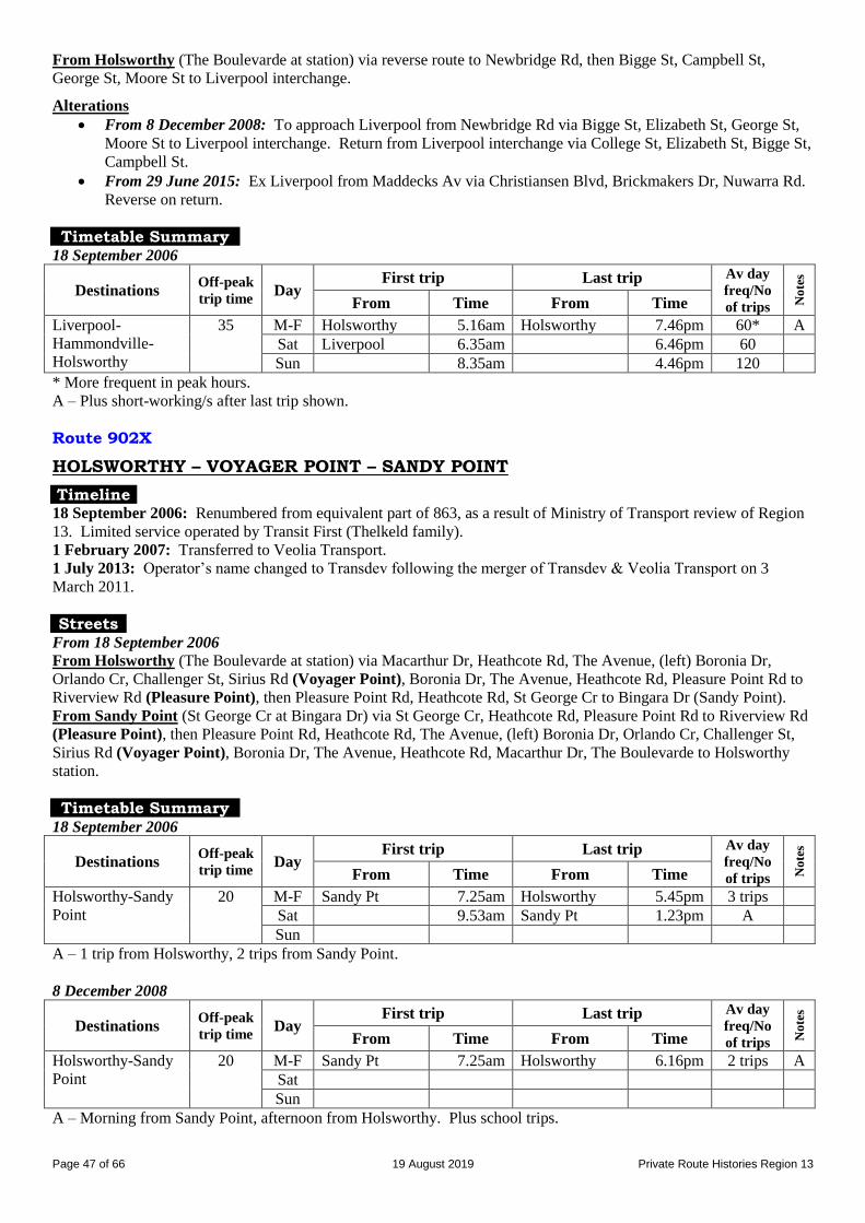
Page 47 of 66 19 August 2019 Private Route Histories Region 13
From Holsworthy (The Boulevarde at station) via reverse route to Newbridge Rd, then Bigge St, Campbell St,
George St, Moore St to Liverpool interchange.
Alterations
From 8 December 2008: To approach Liverpool from Newbridge Rd via Bigge St, Elizabeth St, George St,
Moore St to Liverpool interchange. Return from Liverpool interchange via College St, Elizabeth St, Bigge St,
Campbell St.
From 29 June 2015: Ex Liverpool from Maddecks Av via Christiansen Blvd, Brickmakers Dr, Nuwarra Rd.
Reverse on return.
Timetable Summary 18 September 2006
Destinations Off-peak
trip time Day
First trip Last trip Av day
freq/No
of trips No
tes
From Time From Time
Liverpool-
Hammondville-
Holsworthy
35 M-F Holsworthy 5.16am Holsworthy 7.46pm 60* A
Sat Liverpool 6.35am 6.46pm 60
Sun 8.35am 4.46pm 120
* More frequent in peak hours. A – Plus short-working/s after last trip shown.
Route 902X
HOLSWORTHY – VOYAGER POINT – SANDY POINT
Timeline 18 September 2006: Renumbered from equivalent part of 863, as a result of Ministry of Transport review of Region
13. Limited service operated by Transit First (Thelkeld family).
1 February 2007: Transferred to Veolia Transport.
1 July 2013: Operator’s name changed to Transdev following the merger of Transdev & Veolia Transport on 3
March 2011.
Streets From 18 September 2006
From Holsworthy (The Boulevarde at station) via Macarthur Dr, Heathcote Rd, The Avenue, (left) Boronia Dr,
Orlando Cr, Challenger St, Sirius Rd (Voyager Point), Boronia Dr, The Avenue, Heathcote Rd, Pleasure Point Rd to
Riverview Rd (Pleasure Point), then Pleasure Point Rd, Heathcote Rd, St George Cr to Bingara Dr (Sandy Point).
From Sandy Point (St George Cr at Bingara Dr) via St George Cr, Heathcote Rd, Pleasure Point Rd to Riverview Rd
(Pleasure Point), then Pleasure Point Rd, Heathcote Rd, The Avenue, (left) Boronia Dr, Orlando Cr, Challenger St,
Sirius Rd (Voyager Point), Boronia Dr, The Avenue, Heathcote Rd, Macarthur Dr, The Boulevarde to Holsworthy
station.
Timetable Summary 18 September 2006
Destinations Off-peak
trip time Day
First trip Last trip Av day
freq/No
of trips No
tes
From Time From Time
Holsworthy-Sandy
Point
20 M-F Sandy Pt 7.25am Holsworthy 5.45pm 3 trips
Sat 9.53am Sandy Pt 1.23pm A
Sun
A – 1 trip from Holsworthy, 2 trips from Sandy Point.
8 December 2008
Destinations Off-peak
trip time Day
First trip Last trip Av day
freq/No
of trips No
tes
From Time From Time
Holsworthy-Sandy
Point
20 M-F Sandy Pt 7.25am Holsworthy 6.16pm 2 trips A
Sat
Sun
A – Morning from Sandy Point, afternoon from Holsworthy. Plus school trips.
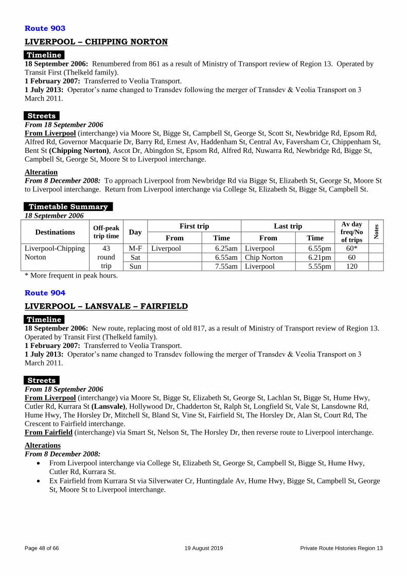
Page 48 of 66 19 August 2019 Private Route Histories Region 13
Route 903
LIVERPOOL – CHIPPING NORTON
Timeline 18 September 2006: Renumbered from 861 as a result of Ministry of Transport review of Region 13. Operated by
Transit First (Thelkeld family).
1 February 2007: Transferred to Veolia Transport.
1 July 2013: Operator’s name changed to Transdev following the merger of Transdev & Veolia Transport on 3
March 2011.
Streets From 18 September 2006
From Liverpool (interchange) via Moore St, Bigge St, Campbell St, George St, Scott St, Newbridge Rd, Epsom Rd,
Alfred Rd, Governor Macquarie Dr, Barry Rd, Ernest Av, Haddenham St, Central Av, Faversham Cr, Chippenham St,
Bent St (Chipping Norton), Ascot Dr, Abingdon St, Epsom Rd, Alfred Rd, Nuwarra Rd, Newbridge Rd, Bigge St,
Campbell St, George St, Moore St to Liverpool interchange.
Alteration
From 8 December 2008: To approach Liverpool from Newbridge Rd via Bigge St, Elizabeth St, George St, Moore St
to Liverpool interchange. Return from Liverpool interchange via College St, Elizabeth St, Bigge St, Campbell St.
Timetable Summary 18 September 2006
Destinations Off-peak
trip time Day
First trip Last trip Av day
freq/No
of trips No
tes
From Time From Time
Liverpool-Chipping
Norton
43
round
trip
M-F Liverpool 6.25am Liverpool 6.55pm 60*
Sat 6.55am Chip Norton 6.21pm 60
Sun 7.55am Liverpool 5.55pm 120
* More frequent in peak hours.
Route 904
LIVERPOOL – LANSVALE – FAIRFIELD
Timeline 18 September 2006: New route, replacing most of old 817, as a result of Ministry of Transport review of Region 13.
Operated by Transit First (Thelkeld family).
1 February 2007: Transferred to Veolia Transport.
1 July 2013: Operator’s name changed to Transdev following the merger of Transdev & Veolia Transport on 3
March 2011.
Streets From 18 September 2006
From Liverpool (interchange) via Moore St, Bigge St, Elizabeth St, George St, Lachlan St, Bigge St, Hume Hwy,
Cutler Rd, Kurrara St (Lansvale), Hollywood Dr, Chadderton St, Ralph St, Longfield St, Vale St, Lansdowne Rd,
Hume Hwy, The Horsley Dr, Mitchell St, Bland St, Vine St, Fairfield St, The Horsley Dr, Alan St, Court Rd, The
Crescent to Fairfield interchange.
From Fairfield (interchange) via Smart St, Nelson St, The Horsley Dr, then reverse route to Liverpool interchange.
Alterations
From 8 December 2008:
From Liverpool interchange via College St, Elizabeth St, George St, Campbell St, Bigge St, Hume Hwy,
Cutler Rd, Kurrara St.
Ex Fairfield from Kurrara St via Silverwater Cr, Huntingdale Av, Hume Hwy, Bigge St, Campbell St, George
St, Moore St to Liverpool interchange.
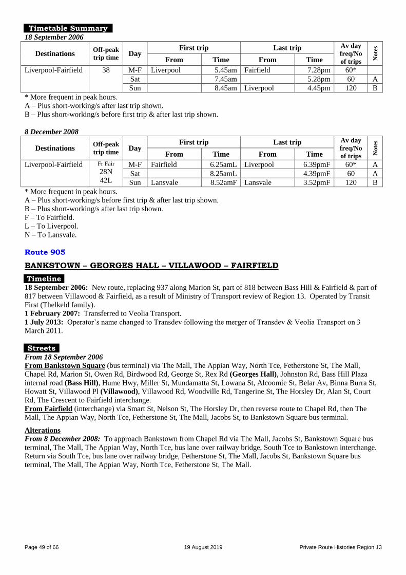
Page 49 of 66 19 August 2019 Private Route Histories Region 13
Timetable Summary 18 September 2006
Destinations Off-peak
trip time Day
First trip Last trip Av day
freq/No
of trips No
tes
From Time From Time
Liverpool-Fairfield 38 M-F Liverpool 5.45am Fairfield 7.28pm 60*
Sat 7.45am 5.28pm 60 A
Sun 8.45am Liverpool 4.45pm 120 B
* More frequent in peak hours. A – Plus short-working/s after last trip shown.
B – Plus short-working/s before first trip & after last trip shown.
8 December 2008
Destinations Off-peak
trip time Day
First trip Last trip Av day
freq/No
of trips No
tes
From Time From Time
Liverpool-Fairfield Fr Fair
28N
42L
M-F Fairfield 6.25amL Liverpool 6.39pmF 60* A
Sat 8.25amL 4.39pmF 60 A
Sun Lansvale 8.52amF Lansvale 3.52pmF 120 B
* More frequent in peak hours. A – Plus short-working/s before first trip & after last trip shown.
B – Plus short-working/s after last trip shown.
F – To Fairfield.
L – To Liverpool.
N – To Lansvale.
Route 905
BANKSTOWN – GEORGES HALL – VILLAWOOD – FAIRFIELD
Timeline 18 September 2006: New route, replacing 937 along Marion St, part of 818 between Bass Hill & Fairfield & part of
817 between Villawood & Fairfield, as a result of Ministry of Transport review of Region 13. Operated by Transit
First (Thelkeld family).
1 February 2007: Transferred to Veolia Transport.
1 July 2013: Operator’s name changed to Transdev following the merger of Transdev & Veolia Transport on 3
March 2011.
Streets From 18 September 2006
From Bankstown Square (bus terminal) via The Mall, The Appian Way, North Tce, Fetherstone St, The Mall,
Chapel Rd, Marion St, Owen Rd, Birdwood Rd, George St, Rex Rd (Georges Hall), Johnston Rd, Bass Hill Plaza
internal road (Bass Hill), Hume Hwy, Miller St, Mundamatta St, Lowana St, Alcoomie St, Belar Av, Binna Burra St,
Howatt St, Villawood Pl (Villawood), Villawood Rd, Woodville Rd, Tangerine St, The Horsley Dr, Alan St, Court
Rd, The Crescent to Fairfield interchange.
From Fairfield (interchange) via Smart St, Nelson St, The Horsley Dr, then reverse route to Chapel Rd, then The
Mall, The Appian Way, North Tce, Fetherstone St, The Mall, Jacobs St, to Bankstown Square bus terminal.
Alterations
From 8 December 2008: To approach Bankstown from Chapel Rd via The Mall, Jacobs St, Bankstown Square bus
terminal, The Mall, The Appian Way, North Tce, bus lane over railway bridge, South Tce to Bankstown interchange.
Return via South Tce, bus lane over railway bridge, Fetherstone St, The Mall, Jacobs St, Bankstown Square bus
terminal, The Mall, The Appian Way, North Tce, Fetherstone St, The Mall.
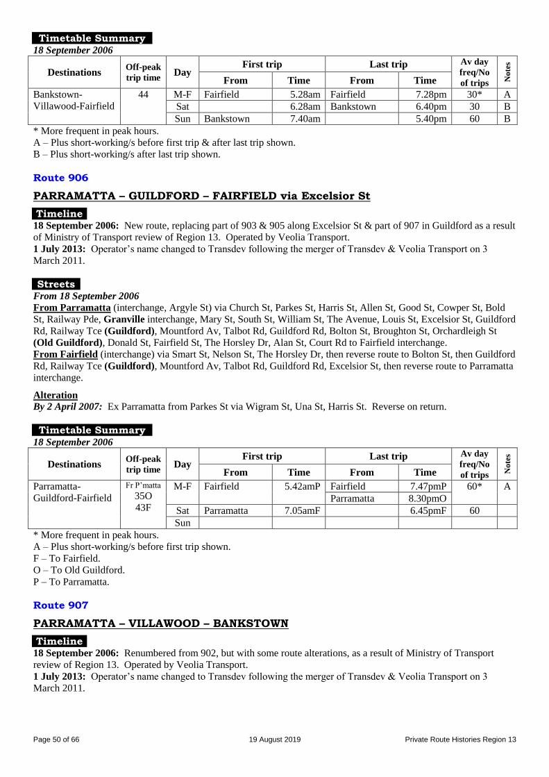
Page 50 of 66 19 August 2019 Private Route Histories Region 13
Timetable Summary 18 September 2006
Destinations Off-peak
trip time Day
First trip Last trip Av day
freq/No
of trips No
tes
From Time From Time
Bankstown-
Villawood-Fairfield
44 M-F Fairfield 5.28am Fairfield 7.28pm 30* A
Sat 6.28am Bankstown 6.40pm 30 B
Sun Bankstown 7.40am 5.40pm 60 B
* More frequent in peak hours. A – Plus short-working/s before first trip & after last trip shown.
B – Plus short-working/s after last trip shown.
Route 906
PARRAMATTA – GUILDFORD – FAIRFIELD via Excelsior St
Timeline 18 September 2006: New route, replacing part of 903 & 905 along Excelsior St & part of 907 in Guildford as a result
of Ministry of Transport review of Region 13. Operated by Veolia Transport.
1 July 2013: Operator’s name changed to Transdev following the merger of Transdev & Veolia Transport on 3
March 2011.
Streets From 18 September 2006
From Parramatta (interchange, Argyle St) via Church St, Parkes St, Harris St, Allen St, Good St, Cowper St, Bold
St, Railway Pde, Granville interchange, Mary St, South St, William St, The Avenue, Louis St, Excelsior St, Guildford
Rd, Railway Tce (Guildford), Mountford Av, Talbot Rd, Guildford Rd, Bolton St, Broughton St, Orchardleigh St
(Old Guildford), Donald St, Fairfield St, The Horsley Dr, Alan St, Court Rd to Fairfield interchange.
From Fairfield (interchange) via Smart St, Nelson St, The Horsley Dr, then reverse route to Bolton St, then Guildford
Rd, Railway Tce (Guildford), Mountford Av, Talbot Rd, Guildford Rd, Excelsior St, then reverse route to Parramatta
interchange.
Alteration
By 2 April 2007: Ex Parramatta from Parkes St via Wigram St, Una St, Harris St. Reverse on return.
Timetable Summary 18 September 2006
Destinations Off-peak
trip time Day
First trip Last trip Av day
freq/No
of trips No
tes
From Time From Time
Parramatta-
Guildford-Fairfield
Fr P’matta
35O
43F
M-F Fairfield 5.42amP Fairfield 7.47pmP 60* A
Parramatta 8.30pmO
Sat Parramatta 7.05amF 6.45pmF 60
Sun
* More frequent in peak hours. A – Plus short-working/s before first trip shown.
F – To Fairfield.
O – To Old Guildford.
P – To Parramatta.
Route 907
PARRAMATTA – VILLAWOOD – BANKSTOWN
Timeline 18 September 2006: Renumbered from 902, but with some route alterations, as a result of Ministry of Transport
review of Region 13. Operated by Veolia Transport.
1 July 2013: Operator’s name changed to Transdev following the merger of Transdev & Veolia Transport on 3
March 2011.
Page 51 of 66 19 August 2019 Private Route Histories Region 13
Streets From 18 September 2006
From Parramatta (interchange, Argyle St) via Church St, Woodville Rd (Villawood), Hume Hwy, Johnston Rd,
Bass Hill Plaza internal road (Bass Hill), Hume Hwy (Yagoona), Chapel Rd, The Mall, The Appian Way, North Tce,
Fetherstone St, The Mall, Jacobs St to Bankstown Square bus terminal.
From Bankstown Square (bus terminal) via The Mall, The Appian Way, North Tce, Fetherstone St, The Mall,
Chapel Rd, then reverse route to Parramatta.
Alterations
From 8 December 2008 (opening of Bankstown bus lane):
Ex Bankstown from Chapel Rd via Hume Hwy, Arundle Rd, Johnston Rd. Unaltered ex Parramatta.
To approach Bankstown from Chapel Rd via Rickard Rd, Jacobs St, Bankstown Square bus terminal, The
Mall, The Appian Way, North Tce, bus lane over railway bridge, South Tce to Bankstown interchange. From
Bankstown (interchange, South Tce) via bus lane over railway bridge, Fetherstone St, The Mall to Bankstown
Square bus terminal, Jacobs St, Rickard Rd, Chapel Rd.
Timetable Summary 18 September 2006
Destinations Off-peak
trip time Day
First trip Last trip Av day
freq/No
of trips No
tes
From Time From Time
Parramatta-
Villawood-
Bankstown
52 M-F Parramatta 5.30am Bankstown 8.20pm 30 A
Sat 7.50am 7.20pm 30 A
Sun 8.10am 6.20pm 60 A
A – Plus short-working/s before first trip & after last trip shown.
Route 908
BANKSTOWN – AUBURN – MERRYLANDS
Timeline 18 September 2006: New route , replacing parts of 908, 910, 919 & 921, as a result of Ministry of Transport review
of Region 13. Operated by Veolia Transport.
By 14 March 2011: Rerouted via Powell St, instead of Woodbine St, Potts Hill, to cover part of 925, which was
rerouted via Muir Rd & Hume Hwy at that date. 909 continues to serve Woodbine St area, Potts Hill.
1 July 2013: Operator’s name changed to Transdev following the merger of Transdev & Veolia Transport on 3
March 2011.
Streets From 18 September 2006
From Bankstown Square (bus terminal) via The Mall, The Appian Way, North Tce, Fetherstone St, The Mall,
Chapel Rd, Rickard Rd, Meredith St, The Boulevarde, George St, Avoca St, Palomar Pde (Potts Hill), Woodbine St,
Ashby Av, Brunker Rd, Ferrier Rd, Rose St, Wellington Rd, Woods Rd, Carlingford St, Amy St (Regents Park),
Nottinghill Rd, Kibo Rd, Fourth Av, Hyde Park Rd, Bourke Av, Campbell St (Berala), London Rd, Brixton Rd, Kerrs
Rd, Tilba St, Graham St, Vaughan St, Woodburn Av, Cockthorpe Rd, Norval St (Auburn Hospital), Auburn Rd,
Mary St, Park Rd, South Pde (Auburn), Auburn Rd, Mary St, Park Rd, Queen St, Normanby Rd, Cumberland Rd,
Mona St, Clyde St, Rawson Rd (South Granville), Excelsior St, Louis St, The Avenue, William St, Mombri St, Neil
St, Pitt St, Merrylands interchange.
From Merrylands (interchange) via reverse route to Normanby Rd, then Park Rd, South Pde (Auburn), Auburn Rd,
Norval St, then reverse route to Chapel Rd, then The Mall, The Appian Way, North Tce, Fetherstone St, The Mall,
Jacobs St to Bankstown Square bus terminal.
Alterations
From 8 December 2008 (opening of Bankstown bus lane): To approach Bankstown from Chapel Rd via
Rickard Rd, Jacobs St, Bankstown Square bus terminal, The Mall, The Appian Way, North Tce, bus lane over
railway bridge, South Tce to Bankstown interchange. From Bankstown (interchange, South Tce) via bus lane
over railway bridge, Fetherstone St, The Mall to Bankstown Square bus terminal, Jacobs St, Rickard Rd,
Chapel Rd.
By 14 December 2009: Ex Bankstown from Woodburn Av via Water St, Hargrave Rd, Norval St. Reverse
on return.

Page 52 of 66 19 August 2019 Private Route Histories Region 13
By 14 March 2011: Ex Bankstown from Chapel Rd via Rookwood Rd, George St, Powell St, Brunker Rd.
Ex Parramatta from Brunker Rd, Rookwood Rd, Chapel Rd.
From 28 November 2011: Ex Bankstown from Norval St via Auburn Rd, Beatrice St, Susan St, Queen St,
Civic Rd, South Pde (Auburn), Park Rd, Queen St, Normanby St, Kerr Pde. Unaltered ex Merrylands.
Timetable Summary 18 September 2006
Destinations Off-peak
trip time Day
First trip Last trip Av day
freq/No
of trips No
tes
From Time From Time
Bankstown-
Auburn-Merrylands
Fr Banks
38A
67M
M-F Bankstown 5.50amA
6.50amM
Merrylands 5.35pmB 60*
Auburn 7.02pmB
Sat 7.50amM Merrylands 3.35pmB 60 C
Sun
* More frequent in peak hours. A – To Auburn.
B – To Bankstown.
C – Plus short-working/s before first trip & after last trip shown.
M – To Merrylands.
6 December 2010
Destinations Off-peak
trip time Day
First trip Last trip Av day
freq/No
of trips No
tes
From Time From Time
Bankstown-
Auburn-Merrylands
Fr Banks
34A
73M
M-F Bankstown 7.42amM Merrylands 4.30pmB 60 C Sat 7.47amM 3.35pmB 60 C Sun Auburn Hosp 8.21amM 3.35pmH 60 D
* More frequent in peak hours. A – To Auburn.
B – To Bankstown.
C – Plus short-working/s before first trip & after last trip shown.
D – Sunday service on trial for 6 months, later made permanent. Plus short-working/s before first trip & after last trip
shown.
H – To Auburn Hospital.
M – To Merrylands.
Route 909
PARRAMATTA – AUBURN – REGENTS PARK – BANKSTOWN
Timeline 18 September 2006: New route , replacing parts of 904, 918, 919 & 921 as a result of Ministry of Transport review
of Region 13. Operated by Transit First (Thelkeld family).
1 February 2007: Transferred to Veolia Transport.
1 July 2013: Operator’s name changed to Transdev following the merger of Transdev & Veolia Transport on 3
March 2011.
Streets From 18 September 2006
From Parramatta (interchange, Argyle St) via Church St, Parkes St, Hassall St, Alfred St, Parramatta Rd, Station
Rd, Rawson St (Auburn), railway bridge, South Pde, Auburn Rd, Mary St, Cumberland Rd, St Johns Rd (South
Granville), Chisholm Rd, Princes Rd, Jenkins St, Kingsland Rd, Amy St (Regents Park), Auburn Rd, Ferrier Rd,
Brunker Rd, Ashby Av, Woodbine St, Palomar Pde (Potts Hill), Avoca St, George St, Meredith St, Rickard Rd,
Chapel Rd, The Mall, The Appian Way, North Tce, Fetherstone St, The Mall, Jacobs St to Bankstown Square bus
terminal.
From Bankstown Square (bus terminal) via The Mall, The Appian Way, North Tce, Fetherstone St, The Mall,
Chapel Rd, then reverse route to Mary St, then Park Rd, South Pde (Auburn), Auburn Rd, Mary St, Park Rd, South
Pde, railway bridge, then reverse route to Parramatta interchange.
Page 53 of 66 19 August 2019 Private Route Histories Region 13
Alterations
From 8 December 2008 (opening of Bankstown bus lane): To approach Bankstown from Rickard Rd via
Jacobs St, Bankstown Square bus terminal, The Mall, The Appian Way, North Tce, bus lane over railway
bridge, South Tce to Bankstown interchange. From Bankstown (interchange, South Tce) via bus lane over
railway bridge, Fetherstone St, The Mall to Bankstown Square bus terminal, Jacobs St, Rickard Rd, Chapel
Rd.
From 8 December 2008: To approach Parramatta from Parkes St via Valentine Av, Church St, Argyle St.
Unaltered ex Parramatta.
From 28 November 2011: Ex Parramatta from Station St via Kerr Pde, South Pde (Auburn), Park Rd, Mary
St, Cumberland Rd. Reverse on return.
Timetable Summary 18 September 2006
Destinations Off-peak
trip time Day
First trip Last trip Av day
freq/No
of trips No
tes
From Time From Time
Parramatta-Auburn-
Bankstown
57 M-F Bankstown 5.31am Parramatta 7.33pm 30 A
Sat 6.31am 7.33pm 30 B
Sun 8.29am 4.33pm 60 C
A – Plus short-working/s after last trip shown.
B – Plus short-working/s before first trip shown.
C – Plus short-working/s before first trip & after last trip shown.
Route 910
PARRAMATTA – GRANVILLE – CHESTER HILL – BANKSTOWN via Blaxcell St
Timeline 18 September 2006: New route, replacing parts of 903, 905, 908 & previous 910 as a result of Ministry of Transport
review of Region 13. Operated by Veolia Transport.
7 February 2011: Amalgamated with 948 as M91, Parramatta – Chester Hill – Bankstown – Padstow – Hurstville.
Streets From 18 September 2006
From Parramatta (interchange, Argyle St) via Church St, Parramatta Rd, Bold St, Railway Pde, South St, Mary St,
Granville interchange, Railway Pde, South St, William St, Blaxcell St, Rawson Rd (South Granville), Campbell Hill
Rd, Virgil Av, Priam St, Waldron Rd (Chester Hill), Chester Hill Rd, Proctor Pde, Hector St, Buist St, Rose St,
Brodie St, McMahon Rd, Church Rd, Hume Hwy (Yagoona), Chapel Rd, The Mall, The Appian Way, North Tce,
Fetherstone St, The Mall, Jacobs St to Bankstown Square bus terminal.
From Bankstown Square (bus terminal) via The Mall, The Appian Way, North Tce, Fetherstone St, The Mall,
Chapel Rd, then reverse route to Chester Hill Rd, then Waldron Rd (Chester Hill), Campbell Hill Rd, then reverse
route to South St, then Mary St, Granville interchange, Railway Pde, Bold St, Parramatta Rd, Church St, Argyle St to
Parramatta interchange.
Alterations
By 2 April 2007: Ex Parramatta from Church St via Woodville Rd, Halsall St, Milton St, Railway Pde. Ex
Bankstown unaltered.
From 8 December 2008 (opening of Bankstown bus lane): To approach Bankstown from Chapel Rd via
Rickard Rd, Jacobs St, Bankstown Square bus terminal, The Mall, The Appian Way, North Tce, bus lane over
bridge, South Tce to Bankstown station. From Bankstown (interchange via bus lane over bridge, Fetherstone
St, The Mall, Bankstown Square bus terminal, Jacobs St, Rickard Rd, Chapel Rd.

Page 54 of 66 19 August 2019 Private Route Histories Region 13
Timetable Summary 18 September 2006
Destinations Off-peak
trip time Day
First trip Last trip Av day
freq/No
of trips No
tes
From Time From Time
Parramatta-Chester
Hill-Bankstown
51 M-F Bankstown 6.00am Parramatta 11.30pm 30* A
Sat 7.30am 8.00pm 30 B
Sun 9.00am Bankstown 7.00pm 60 B
* More frequent in peak hours. A – Plus short-working/s before first trip shown.
B – Plus short-working/s before first trip & after last trip shown.
Route 911
AUBURN – CHESTER HILL – GEORGES HALL – BANKSTOWN
Timeline 18 September 2006: New route, replacing parts of 910, 917 & 936, as a result of Ministry of Transport review of
Region 13. Operated by Transit First (Thelkeld family).
1 February 2007: Transferred to Veolia Transport.
1 July 2013: Operator’s name changed to Transdev following the merger of Transdev & Veolia Transport on 3
March 2011.
Streets From 18 September 2006
From Auburn (South Pde at station) via Auburn Rd, Mary St, Park Rd, Wellington Rd (South Granville), Ferndell
St, Boundary Rd, Hector St, Waldron Rd (Chester Hill), Chester Hill Rd, Hume Hwy (Bass Hill), Bass Hill Plaza
internal road, Johnston Rd, Denman Rd, Athel St, Jacaranda Dr, Ash St, Oak Dr, Bangalay St, Flinders Rd, Amaroo
Av, Bambil St (Georges Hall), Rex Rd, Bellevue Av, Georgina St, Warringa St, Bertram St, Glassop St (Yagoona
West), Melanie St, Carmen St, Meredith St, Rickard Rd, Chapel Rd, The Mall, The Appian Way, North Tce,
Fetherstone St, The Mall, Jacobs St to Bankstown Square bus terminal.
From Bankstown Square (bus terminal) via The Mall, The Appian Way, North Tce, Fetherstone St, The Mall,
Chapel Rd, then reverse route to Park Rd, then South Pde to Auburn station.
Alterations
From 8 December 2008 (opening of Bankstown bus lane): To approach Bankstown from Chapel Rd via
Rickard Rd, Jacobs St, Bankstown Square bus terminal, The Mall, The Appian Way, North Tce, bus lane over
bridge, South Tce to Bankstown interchange. From Bankstown (interchange, South Tce) via bus lane over
bridge, Fetherstone St, The Mall, Bankstown Square bus terminal, Jacobs St, Rickard Rd, Chapel Rd.
From 8 December 2008 (Bankstown – Georges Hall trips): Ex Bankstown from Rex Rd via Ashcroft St to
Beale St. Return via Haig Av, Georges Cr, Rex Rd.
Timetable Summary 18 September 2006
Destinations Off-peak
trip time Day
First trip Last trip Av day
freq/No
of trips No
tes
From Time From Time
Auburn-Chester
Hill-Bankstown
53 M-F Auburn 6.00am Auburn 6.00pm 60* A Sat 7.00am 5.00pm 60 A Sun
* More frequent in peak hours. A – Plus short-working/s before first trip & after last trip shown.
Page 55 of 66 19 August 2019 Private Route Histories Region 13
Route 912
LIDCOMBE – BANKSTOWN via Botanica Estate & Rookwood Rd
General note: Similar to 920, which ceased 27 July 2003.
Timeline 18 September 2006: New route, replacing parts of 918 & 919 as a result of Ministry of Transport review of Region
13. Operated by Veolia Transport.
14 December 2009: Amalgamated with 925 as 925, Lidcombe – Bankstown – East Hills.
Streets From 18 September 2006
From Lidcombe (Railway St at station) via Mark St, James St, East St, Georges Av, Joseph St, Botanica Dr, Main Av
(Botanica Estate), Joseph St, Rookwood Rd, Chapel Rd, The Mall, The Appian Way, North Tce, Fetherstone St, The
Mall, Jacobs St to Bankstown Square bus terminal.
From Bankstown Square (bus terminal) via The Mall, The Appian Way, North Tce, Fetherstone St, The Mall,
Chapel Rd, then reverse route to Rookwood Rd, then Joseph St, Botanica Dr, Main Av (Botanica Estate), Betty
Cuthbert Dr, Palm Circ, Botanica Dr, Joseph St, then reverse route to James St, then Joseph St, Bridge St, Tooheys
Lane, Railway St to Lidcombe station.
Alterations
By 2 April 2007: From Lidcombe station via Railway St, East St.
From 8 December 2008 (opening of Bankstown bus lane): To approach Bankstown from Chapel Rd via
Rickard Rd, Jacobs St, Bankstown Square bus terminal, The Mall, The Appian Way, North Tce, bus lane over
bridge, South Tce to Bankstown interchange. From Bankstown (interchange, South Tce) via bus lane over
bridge, Fetherstone St, The Mall, Bankstown Square bus terminal, Jacobs St, Rickard Rd, Chapel Rd.
Timetable Summary 18 September 2006
Destinations Off-peak
trip time Day
First trip Last trip Av day
freq/No
of trips No
tes
From Time From Time
Lidcombe-
Bankstown
25 M-F Bankstown 5.37am Lidcombe 8.35pm 60*
Sat 6.37am 7.05pm 60
Sun Lidcombe 8.50am 4.50pm 60 A
* More frequent in peak hours. A – Plus short-working/s before first trip shown.
Route 913
STRATHFIELD – BANKSTOWN via Norfolk Rd & Hillcrest Av
Timeline 18 September 2006: New route, replacing parts of 485 & 486, as a result of Ministry of Transport review of Region
13. Shares part of route with 900 & 914. Operated by Transit First (Thelkeld family).
1 February 2007: Transferred to Veolia Transport.
1 July 2013: Operator’s name changed to Transdev following the merger of Transdev & Veolia Transport on 3
March 2011.
Streets From 18 September 2006
From Strathfield (Albert Rd at station) via Churchill Av, Raw Sq, Redmyre Rd, The Boulevarde (Enfield), Hume
Hwy, Roberts Rd, Norfolk Rd, Waterloo Rd, Shellcote Rd, Noble Av, Cardigan Rd (Greenacre), Hillcrest Av,
Chiswick Rd, Highview Av, Boronia Rd, Hume Hwy, Chapel Rd, The Mall, The Appian Way, North Tce, Fetherstone
St, The Mall, Jacobs St to Bankstown Square bus terminal.
From Bankstown Square (bus terminal) via The Mall, The Appian Way, North Tce, Fetherstone St, The Mall,
Chapel Rd, then reverse route to Raw Sq, then Albert Rd to Strathfield station.
Alteration
From 8 December 2008: To approach Bankstown from Chapel Rd via Rickard Rd, Jacobs St, Bankstown Square bus
terminal, The Mall, The Appian Way, North Tce, bus lane over bridge, South Tce to Bankstown interchange. Return
Page 56 of 66 19 August 2019 Private Route Histories Region 13
via South Tce, bus lane over bridge, Fetherstone St, The Mall, Bankstown Square bus terminal, Jacobs St, Rickard Rd,
Chapel Rd.
Timetable Summary 18 September 2006
Destinations Off-peak
trip time Day
First trip Last trip Av day
freq/No
of trips No
tes
From Time From Time
Strathfield-
Bankstown
41 M-F Bankstown 5.56am Strathfield 5.40pm 60
Sat
Sun
Route 914
STRATHFIELD – GREENACRE
Timeline 18 September 2006: Renumbered from 484, as a result of Ministry of Transport review of Region 13. Shares part of
route with 900 & 913. Operated by Transit First (Thelkeld family).
1 February 2007: Transferred to Veolia Transport.
1 July 2013: Operator’s name changed to Transdev following the merger of Transdev & Veolia Transport on 3
March 2011.
Streets From 18 September 2006
From Strathfield (Albert Rd at station) via Churchill Av, Raw Sq, Redmyre Rd, The Boulevarde (Enfield), Hume
Hwy, Roberts Rd, Juno Pde, Waterloo Rd to Greenacre shops.
From Greenacre (Waterloo Rd at shops) via Wangee Rd, Roberts Rd, then reverse route to Raw Sq, then Albert Rd
to Strathfield station.
Timetable Summary 18 September 2006
Destinations Off-peak
trip time Day
First trip Last trip Av day
freq/No
of trips No
tes
From Time From Time
Strathfield-
Greenacre
24 M-F Greenacre 6.00am Strathfield 6.00pm Ph
Sat
Sun
Ph – Peak hours only.
Route 915
For details of Route 915 prior to 18 September 2006, see (A) Route Histories prior to 18 September 2006 above.
LIDCOMBE – UNIVERSITY of SYDNEY Cumberland campus
Timeline As at 18 September 2006: Being operated by Transit First (Thelkeld family).
1 February 2007: Transferred to Veolia Transport.
14 March 2011: Shares Lidcombe – University of Sydney, Cumberland campus with M92 (with 915 continuing to
run all day on weekdays during semesters till early 2013, when it was reduced to peak hours only).
1 July 2013: Operator’s name changed to Transdev following the merger of Transdev & Veolia Transport on 3
March 2011.
By 22 September 2014: Reduced to operate in peak hours Mondays to Thursdays during semesters.
Streets
From 18 September 2006
From Lidcombe (Railway St at station) via Mark St, James St, East St to within grounds of University of Sydney,
Cumberland campus.
From University of Sydney (within grounds of Cumberland campus) via East St, James St, Joseph St, Bridge St,
Tooheys Lane, Railway St to Lidcombe station.

Page 57 of 66 19 August 2019 Private Route Histories Region 13
Alteration
By 2 April 2007: From Lidcombe station via Railway St, East St.
By 22 September 2014
Morning From Lidcombe (Church St at station) via railway bridge, Railway St, East St (University of Sydney, Cumberland
campus), Weeroona Rd, Joseph St, Olympic Dr, Church St to Lidcombe station.
Afternoon Reverse route.
Timetable Summary 18 September 2006
Destinations Off-peak
trip time Day
First trip Last trip Av day
freq/No
of trips No
tes
From Time From Time
Lidcombe-Uni of
Sydney Cumb’land
campus
5 M-F Lidcombe 7.15am Cumb campus 6.15pm A
Sat
Sun
* More frequent in peak hours. A – Semesters 15*. Stuvac & exams 15.
22 September 2014
Destinations Off-peak
trip time Day
First trip Last trip Av day
freq/No
of trips No
tes
From Time From Time
Lidcombe-Uni of
Sydney Cumb’land
campus
16
round
trip
M-F Lidcombe 7.28am Cumb campus 4.58pm Ph
Sat
Sun
Ph – Peak hours only, Monday-Thursday.
Route 916
CHESTER HILL – BARBERS RD Extended from Barbers Rd to Guildford (selected trips)
Timeline 18 September 2006: Renumbered from 907, as a result of Ministry of Transport review of Region 13. Operated by
Veolia Transport.
1 July 2013: Operator’s name changed to Transdev following the merger of Transdev & Veolia Transport on 3
March 2011.
Streets
Chester Hill – Barbers Rd From 18 September 2006
From Chester Hill (Waldron Rd at station) via Campell Hill Rd, Curtis Rd, Miller Rd, Barbers Rd, Woodville Rd,
Gurney Rd, Miller Rd, Curtis Rd, Campbell Hill Rd, Virgil Av, Priam St, Waldron Rd to Chester Hill station.
Chester Hill – Guildford From 18 September 2006
From Chester Hill (Waldron Rd at station) via Campell Hill Rd, Curtis Rd, Miller Rd, Gurney Rd, Woodville Rd,
Orchardleigh St, Broughton St, Bolton St, Guildford Rd, Railway Tce to Guildford station.
From Guildford (Railway Tce at station) via Mountford Av, Talbot Rd, Guildford Rd, then reverse route to Campbell
Hill Rd, then Virgil Av, Priam St, Waldron Rd to Chester Hill station.

Page 58 of 66 19 August 2019 Private Route Histories Region 13
Timetable Summary 18 September 2006
Destinations Off-peak
trip time Day
First trip Last trip Av day
freq/No
of trips No
tes
From Time From Time
Chester Hill-
Barbers Rd†
Fr C Hill
8B
16G
M-F Chester Hill 10.15am Barbers Rd 2.03pm 3 trips A
Sat
Sun
† Limited service extended to Guildford.
A – Plus 1 trip Chester Hill-Guildford & return. Plus school trips.
B – To Barbers Rd.
G – To Guildford.
Route 925
For details of Route 925 prior to 18 September 2006, see Private Route Histories – Contract Region 10.
LIDCOMBE – BANKSTOWN – CONDELL PARK – PANANIA – EAST HILLS
Timeline 18 September 2006:
New route, Bankstown – Condell Park – Panania – East Hills, replacing parts of 924, 925, 926, 930 & 935 as
a result of Ministry of Transport review of Region 13.
Selected trips ran Bankstown – Bankstown Hospital.
Operated by Transit First (Thelkeld family).
1 February 2007: Transferred to Veolia Transport.
14 December 2009: 912 & 925 amalgamated as 925, Lidcombe – Bankstown – Condell Park – Panania – East Hills.
Selected trips continue to run Bankstown – Bankstown Hospital or Lidcombe – Bankstown – Bankstown Hospital.
14 March 2011: Rerouted via Muir Rd & Hume Hwy instead of part of Rookwood Rd. Rerouted 908 serves part of
missed section of Rookwood Rd.
1 July 2013: Operator’s name changed to Transdev following the merger of Transdev & Veolia Transport on 3
March 2011.
Streets
Bankstown – Condell Park – Panania – East Hills From 18 September 2006
From Bankstown Square (bus terminal) via The Mall, The Appian Way, North Tce, Fetherstone St, The Mall,
Chapel Rd, Marion St, Oxford Av, Chertsey Av, Pringle Av, Lancelot St, Simmat Av (Condell Park), Townsend St,
Fourth Av, Yanderra St, Simmat Av, Eldridge Rd, Edgar St, Queen St, Bransgrove Rd, Benfield Pde, Horsley Rd,
Anderson Av (Panania), Braesmere Rd, Park Rd to East Hills station.
From East Hills (Park Rd at station) via reverse route to Chapel Rd, then The Mall, The Appian Way, North Tce,
Fetherstone St, The Mall, Jacobs St to Bankstown Square bus terminal.
Bankstown Hospital trips: Ex Bankstown from Eldridge Rd via Gallipoli St, Claribel St, Artegall St (Hospital),
Eldridge Rd, then back to Bankstown.
Alterations
By 17 December 2007: Ex Bankstown from Yanderra St via Ethel St instead of Simmat Av. Reverse on
return.
From 8 December 2008 (opening of Bankstown bus lane): From Bankstown Square bus terminal via The
Mall, The Appian Way, North Tce, bus lane over railway bridge, South Tce, Restwell St, Macauley Av,
Chapel Rd, Chelmsford Av, Northam Av, Chertsey Av. Ex East Hills from Chertsey Av via Northam Av,
Chelmsford Av, Chapel Rd, Greenfield Pde, Restwell St, South Tce, bus lane over railway bridge, Fetherstone
St, The Mall, Jacobs St to Bankstown Square terminal.
Lidcombe – Bankstown – Condell Park – Panania – East Hills From 14 December 2009
From Lidcombe (Railway St at station) via 912 to South Tce, Bankstown, then via 925 as above to East Hills (both
routes as from 8 December 2008).
From East Hills (Park Rd at station) via 925 as above to South Tce, Bankstown, then 912 to Lidcombe (both routes
as from 8 December 2008).
Bankstown Hospital trips: Unaltered.
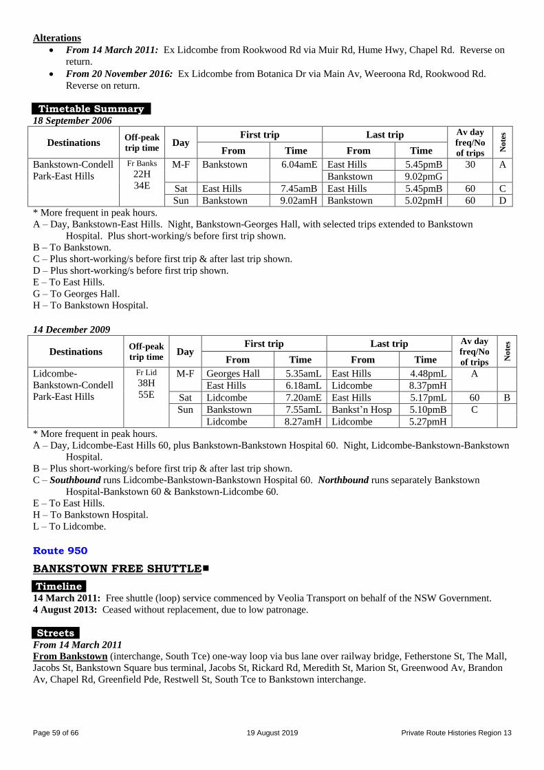
Page 59 of 66 19 August 2019 Private Route Histories Region 13
Alterations
From 14 March 2011: Ex Lidcombe from Rookwood Rd via Muir Rd, Hume Hwy, Chapel Rd. Reverse on
return.
From 20 November 2016: Ex Lidcombe from Botanica Dr via Main Av, Weeroona Rd, Rookwood Rd.
Reverse on return.
Timetable Summary 18 September 2006
Destinations Off-peak
trip time Day
First trip Last trip Av day
freq/No
of trips No
tes
From Time From Time
Bankstown-Condell
Park-East Hills
Fr Banks
22H
34E
M-F Bankstown 6.04amE East Hills 5.45pmB 30 A
Bankstown 9.02pmG
Sat East Hills 7.45amB East Hills 5.45pmB 60 C
Sun Bankstown 9.02amH Bankstown 5.02pmH 60 D
* More frequent in peak hours. A – Day, Bankstown-East Hills. Night, Bankstown-Georges Hall, with selected trips extended to Bankstown
Hospital. Plus short-working/s before first trip shown.
B – To Bankstown.
C – Plus short-working/s before first trip & after last trip shown.
D – Plus short-working/s before first trip shown.
E – To East Hills.
G – To Georges Hall.
H – To Bankstown Hospital.
14 December 2009
Destinations Off-peak
trip time Day
First trip Last trip Av day
freq/No
of trips No
tes
From Time From Time
Lidcombe-
Bankstown-Condell
Park-East Hills
Fr Lid
38H
55E
M-F Georges Hall 5.35amL East Hills 4.48pmL A
East Hills 6.18amL Lidcombe 8.37pmH
Sat Lidcombe 7.20amE East Hills 5.17pmL 60 B
Sun Bankstown 7.55amL Bankst’n Hosp 5.10pmB C
Lidcombe 8.27amH Lidcombe 5.27pmH
* More frequent in peak hours.
A – Day, Lidcombe-East Hills 60, plus Bankstown-Bankstown Hospital 60. Night, Lidcombe-Bankstown-Bankstown
Hospital. B – Plus short-working/s before first trip & after last trip shown.
C – Southbound runs Lidcombe-Bankstown-Bankstown Hospital 60. Northbound runs separately Bankstown
Hospital-Bankstown 60 & Bankstown-Lidcombe 60.
E – To East Hills.
H – To Bankstown Hospital.
L – To Lidcombe.
Route 950
BANKSTOWN FREE SHUTTLE
Timeline 14 March 2011: Free shuttle (loop) service commenced by Veolia Transport on behalf of the NSW Government.
4 August 2013: Ceased without replacement, due to low patronage.
Streets From 14 March 2011
From Bankstown (interchange, South Tce) one-way loop via bus lane over railway bridge, Fetherstone St, The Mall,
Jacobs St, Bankstown Square bus terminal, Jacobs St, Rickard Rd, Meredith St, Marion St, Greenwood Av, Brandon
Av, Chapel Rd, Greenfield Pde, Restwell St, South Tce to Bankstown interchange.

Page 60 of 66 19 August 2019 Private Route Histories Region 13
Timetable Summary 14 March 2011
Destinations Off-peak
trip time Day
First trip Last trip Av day
freq/No
of trips No
tes
From Time From Time
Bankstown free
shuttle
17 M-F Bankstown 9.13am Bankstown 2.23pm 20
Sat 9.13am 5.33pm 20
Sun 9.13am 5.33pm 20
Route 999
LIVERPOOL FREE SHUTTLE
Timeline 31 January 2011: Free shuttle (loop) service commenced by Veolia Transport on behalf of the NSW Government.
4 August 2013: Ceased without replacement, due to low patronage.
Streets From 31 January 2011
From Liverpool (interchange) one-way loop via College St, Elizabeth St, Goulburn St, Campbell St, Forbes St,
Lachlan St, Bigge St, Campbell St, George St, Scott St, Northumberland St, Moore St to Liverpool interchange.
Timetable Summary 31 January 2011
Destinations Off-peak
trip time Day
First trip Last trip Av day
freq/No
of trips No
tes
From Time From Time
Liverpool free
shuttle
20 M-F Liverpool 9.00am Liverpool 2.30pm 22
Sat 9.00am 5.48pm 22
Sun 9.00am 5.48pm 22
Route M90
LIVERPOOL – BANKSTOWN – STRATHFIELD – BURWOOD (METROBUS)
Timeline 6 December 2010:
Renumbered from 900 as part of a Government pre-election programme of “high frequency” Metrobus routes.
First privately operated route to be so classified.
Operated by Veolia Transport.
1 July 2013: Operator’s name changed to Transdev following the merger of Transdev & Veolia Transport on 3
March 2011.
Streets From 6 December 2010
From Liverpool (interchange) via College St, Elizabeth St, Bigge St, Campbell St, George St, Scott St, Newbridge
Rd, Milperra Rd (Milperra), Ashford Av, Bullecourt Av (University of Western Sydney, Bankstown campus),
Horsley Rd, Amour St, Marigold St, Milperra Rd, Canterbury Rd, Chapel St, Macauley Av, Restwell St, South Tce
(Bankstown), bus lane over railway bridge, North Tce, Fetherstone St, The Mall, Jacobs St, Bankstown Square bus
terminal, Jacobs St, Rickard Rd, Chapel Rd, Hume Hwy, Boronia Rd, Noble Rd, Cardigan Rd, Waterloo Rd, Hume
Hwy, The Boulevarde, Redmyre Rd, Raw Sq, Albert Rd (Strathfield), Churchill Av, Raw Sq, Redmyre Rd, The
Boulevarde, Morwick St, Railway Pde, Burwood Rd, Victoria St East to Burwood Westfield.
From Burwood (Burwood Rd at Westfield) via Burwood Rd, Railway Pde, Morwick St, The Boulevarde, Redmyre
Rd, Raw Sq, Albert Rd (Strathfield), Churchill Av, Raw Sq, Redmyre Rd, The Boulevarde, Hume Hwy, then reverse
route to Rickard Rd, then Jacobs St, Bankstown Square bus terminal, The Mall, The Appian Way, North Tce, bus lane
over railway bridge, South Tce (Bankstown), Restwell St, Macauley Av, Chapel Rd, then reverse route to Newbridge
Rd, then Bigge St, Elizabeth St, George St, Moore St to Liverpool interchange.

Page 61 of 66 19 August 2019 Private Route Histories Region 13
Timetable Summary 6 December 2010
Destinations Off-peak
trip time Day
First trip Last trip Av day
freq/No
of trips No
tes
From Time From Time
Liverpool-
Bankstown-
Strathfield-
Burwood
Fr Liv
21M
83S
94B
M-F Milperra 4.56amL Burwood 8.10pmL A
Liverpool 5.10amS
6.00amB
Strathfield 10.52pmK
Sat 6.20amS
7.15amB
Burwood 7.30pmL C
Strathfield 10.57pmK
Sun 7.55amB Burwood 7.30pmL C
Liverpool 8.52pmM
* More frequent in peak hours. A – Early morning & night, various short-workings. Day, Liverpool-Burwood 15*.
B – To Burwood.
C – Day, Liverpool-Burwood 20. Night, various short-workings. Plus short-working/s before first trip shown.
K – To Bankstown.
L – To Liverpool.
M – To Milperra.
S – To Strathfield.
Route M91
PARRAMATTA – CHESTER HILL – BANKSTOWN – PADSTOW – HURSTVILLE
(METROBUS)
Timeline 7 February 2011:
910 & 948 amalgamated and renumbered M91, as part of a Government pre-election programme of “high
frequency” Metrobus routes, originally using buses in a distinctive red livery, running to a standard timetable.
Operated by Veolia Transport.
1 July 2013: Operator’s name changed to Transdev following the merger of Transdev & Veolia Transport on 3
March 2011.
Streets From 7 February 2011 From Parramatta (interchange) via Church St, Woodville Rd, Halsall St, Milson St, Railway Pde, Granville
interchange, Railway Pde, South St, William St, Blaxcell St (South Granville), Rawson Rd, Campbell Hill Rd, Virgil
Av, Priam St, Waldron Rd (Chester Hill), Chester Hill Rd, Proctor Pde, Buist St, Rose St, McMahon St, Church Rd,
Hume Hwy (Yagoona), Chapel Rd, Rickard Rd, Jacobs St, Bankstown Square bus terminal, The Mall, The Appian
Way, North Tce, bus lane over railway bridge, South Tce (Bankstown), Restwell St, Macauley Av, Stacey St,
Fairford Rd, Watson Rd, Cahors Rd, Memorial Dr, Howard Rd (Padstow), Faraday Rd, Alma Rd, Chamberlain Rd,
Clancy St, Henry Lawson Dr, Hall Cr, Dilke Rd, Henry Lawson Dr, Forest Rd, George St, Cambridge St, Forest Rd to
Hurstville station.
From Hurstville (Cross St at Westfield) via Crofts Av, Hurstville interchange*, Forest Rd, McMahon St, Dora St,
Queens Rd, Forest Rd, Cambridge St, George St, Henry Lawson Dr, Hall Cr, Dilke Rd, Henry Lawson Dr, Clancy St,
then reverse route to Restwell St, then South Tce (Bankstown), bus lane over railway bridge, North Tce, Fetherstone
St, The Mall, Jacobs St, Bankstown Square bus terminal, Jacobs St, Rickard Rd, then reverse route to Chester Hill Rd,
then Waldron Rd (Chester Hill), Campbell Hill Rd, then reverse route to South St, then Mary St, Granville
interchange, Railway Pde, Bold St, Parramatta Rd, Church St to Parramatta interchange.
(* This list reflects the route after Hurstville interchange was opened on 11 April 2011. Small variations in the
vicinity of Hurstville interchange would have applied before that date.)
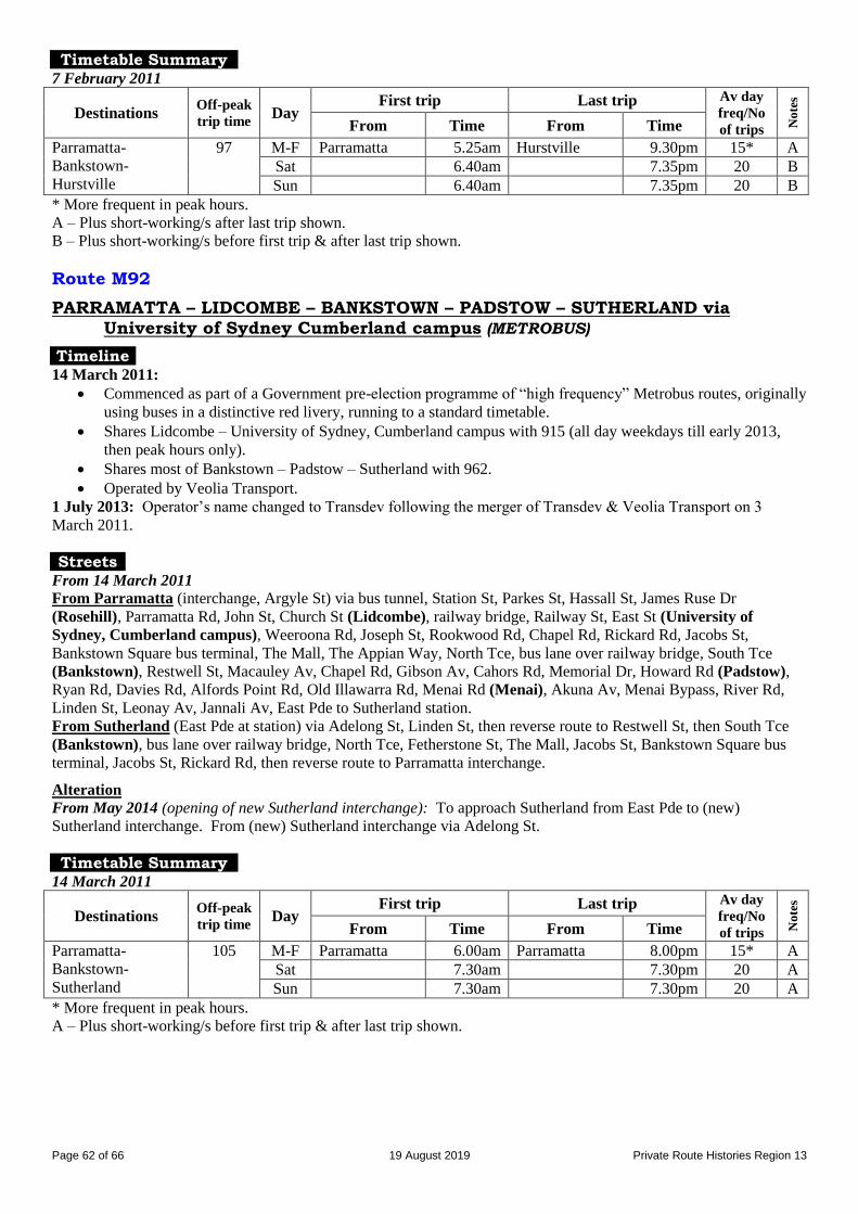
Page 62 of 66 19 August 2019 Private Route Histories Region 13
Timetable Summary 7 February 2011
Destinations Off-peak
trip time Day
First trip Last trip Av day
freq/No
of trips No
tes
From Time From Time
Parramatta-
Bankstown-
Hurstville
97 M-F Parramatta 5.25am Hurstville 9.30pm 15* A
Sat 6.40am 7.35pm 20 B
Sun 6.40am 7.35pm 20 B
* More frequent in peak hours. A – Plus short-working/s after last trip shown.
B – Plus short-working/s before first trip & after last trip shown.
Route M92
PARRAMATTA – LIDCOMBE – BANKSTOWN – PADSTOW – SUTHERLAND via University of Sydney Cumberland campus (METROBUS)
Timeline 14 March 2011:
Commenced as part of a Government pre-election programme of “high frequency” Metrobus routes, originally
using buses in a distinctive red livery, running to a standard timetable.
Shares Lidcombe – University of Sydney, Cumberland campus with 915 (all day weekdays till early 2013,
then peak hours only).
Shares most of Bankstown – Padstow – Sutherland with 962.
Operated by Veolia Transport.
1 July 2013: Operator’s name changed to Transdev following the merger of Transdev & Veolia Transport on 3
March 2011.
Streets From 14 March 2011 From Parramatta (interchange, Argyle St) via bus tunnel, Station St, Parkes St, Hassall St, James Ruse Dr
(Rosehill), Parramatta Rd, John St, Church St (Lidcombe), railway bridge, Railway St, East St (University of
Sydney, Cumberland campus), Weeroona Rd, Joseph St, Rookwood Rd, Chapel Rd, Rickard Rd, Jacobs St,
Bankstown Square bus terminal, The Mall, The Appian Way, North Tce, bus lane over railway bridge, South Tce
(Bankstown), Restwell St, Macauley Av, Chapel Rd, Gibson Av, Cahors Rd, Memorial Dr, Howard Rd (Padstow),
Ryan Rd, Davies Rd, Alfords Point Rd, Old Illawarra Rd, Menai Rd (Menai), Akuna Av, Menai Bypass, River Rd,
Linden St, Leonay Av, Jannali Av, East Pde to Sutherland station.
From Sutherland (East Pde at station) via Adelong St, Linden St, then reverse route to Restwell St, then South Tce
(Bankstown), bus lane over railway bridge, North Tce, Fetherstone St, The Mall, Jacobs St, Bankstown Square bus
terminal, Jacobs St, Rickard Rd, then reverse route to Parramatta interchange.
Alteration
From May 2014 (opening of new Sutherland interchange): To approach Sutherland from East Pde to (new)
Sutherland interchange. From (new) Sutherland interchange via Adelong St.
Timetable Summary 14 March 2011
Destinations Off-peak
trip time Day
First trip Last trip Av day
freq/No
of trips No
tes
From Time From Time
Parramatta-
Bankstown-
Sutherland
105 M-F Parramatta 6.00am Parramatta 8.00pm 15* A
Sat 7.30am 7.30pm 20 A
Sun 7.30am 7.30pm 20 A
* More frequent in peak hours. A – Plus short-working/s before first trip & after last trip shown.
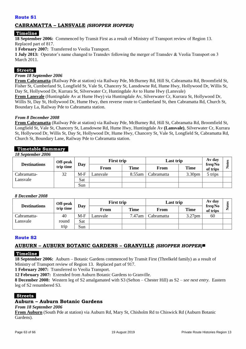
Page 63 of 66 19 August 2019 Private Route Histories Region 13
Route S1
CABRAMATTA – LANSVALE (SHOPPER HOPPER)
Timeline 18 September 2006: Commenced by Transit First as a result of Ministry of Transport review of Region 13.
Replaced part of 817.
1 February 2007: Transferred to Veolia Transport.
1 July 2013: Operator’s name changed to Transdev following the merger of Transdev & Veolia Transport on 3
March 2011.
Streets From 18 September 2006
From Cabramatta (Railway Pde at station) via Railway Pde, McBurney Rd, Hill St, Cabramatta Rd, Broomfield St,
Fisher St, Cumberland St, Longfield St, Vale St, Chancery St, Lansdowne Rd, Hume Hwy, Hollywood Dr, Willis St,
Day St, Hollywood Dr, Kurrara St, Silverwater Cr, Huntingdale Av to Hume Hwy (Lansvale)
From Lansvale (Huntingdale Av at Hume Hwy) via Huntingdale Av, Silverwater Cr, Kurrara St, Hollywood Dr,
Willis St, Day St, Hollywood Dr, Hume Hwy, then reverse route to Cumberland St, then Cabramatta Rd, Church St,
Boundary La, Railway Pde to Cabramatta station.
From 8 December 2008
From Cabramatta (Railway Pde at station) via Railway Pde, McBurney Rd, Hill St, Cabramatta Rd, Broomfield St,
Longfield St, Vale St, Chancery St, Lansdowne Rd, Hume Hwy, Huntingdale Av (Lansvale), Silverwater Cr, Kurrara
St, Hollywood Dr, Willis St, Day St, Hollywood Dr, Hume Hwy, Chancery St, Vale St, Longfield St, Cabramatta Rd,
Church St, Boundary Lane, Railway Pde to Cabramatta station.
Timetable Summary 18 September 2006
Destinations Off-peak
trip time Day
First trip Last trip Av day
freq/No
of trips No
tes
From Time From Time
Cabramatta-
Lansvale
32 M-F Lansvale 8.55am Cabramatta 3.30pm 5 trips
Sat
Sun
8 December 2008
Destinations Off-peak
trip time Day
First trip Last trip Av day
freq/No
of trips No
tes
From Time From Time
Cabramatta-
Lansvale
40
round
trip
M-F Lansvale 7.47am Cabramatta 3.27pm 60
Sat
Sun
Route S2
AUBURN – AUBURN BOTANIC GARDENS – GRANVILLE (SHOPPER HOPPER)
Timeline 18 September 2006: Auburn – Botanic Gardens commenced by Transit First (Threlkeld family) as a result of
Ministry of Transport review of Region 13. Replaced part of 917.
1 February 2007: Transferred to Veolia Transport.
12 February 2007: Extended from Auburn Botanic Gardens to Granville.
8 December 2008: Western leg of S2 amalgamated with S3 (Sefton – Chester Hill) as S2 – see next entry. Eastern
leg of S2 renumbered S3.
Streets
Auburn – Auburn Botanic Gardens From 18 September 2006
From Auburn (South Pde at station) via Auburn Rd, Mary St, Chisholm Rd to Chiswick Rd (Auburn Botanic
Gardens).

Page 64 of 66 19 August 2019 Private Route Histories Region 13
From Auburn Botanic Gardens (Chisholm Rd at Chiswick Rd) via Chisholm Rd, Mary St, Park Rd, South Pde to
Auburn station.
Auburn – Auburn Botanic Gardens – Granville Alteration
From 12 February 2007: From Auburn Botanic Gardens via Wellington Rd, Clyde St, William St, South St, Mary St
to Granville interchange. Reverse on return.
Timetable Summary 18 September 2006
Destinations Off-peak
trip time Day
First trip Last trip Av day
freq/No
of trips No
tes
From Time From Time
Auburn-Botanic
Gardens
10 M-F Auburn 9.25am Botanic Gdns 3.10pm 3 trips
Sat
Sun
12 February 2007
Destinations Off-peak
trip time Day
First trip Last trip Av day
freq/No
of trips No
tes
From Time From Time
Auburn-Botanic
Gardens-Granville
25 M-F Granville 9.15am Auburn 1.42pm 4 trips A
Sat
Sun
A – Plus short-working/s before first trip & after last trip shown.
Route S2
GRANVILLE – CHESTER HILL – SEFTON (SHOPPER HOPPER)
Timeline 8 December 2008: Western leg of S2 amalgamated with S3 (Sefton – Chester Hill) and rerouted as Granville –
Chester Hill – Sefton. Operated by Veolia Transport.
1 July 2013: Operator’s name changed to Transdev following the merger of Transdev & Veolia Transport on 3
March 2011.
Streets From 8 December 2008 From Granville (interchange) via Mary St, South St, William St, Clyde St, Ferndell Rd (South Granville), Boundary
Rd, Hector St, Elliston St, Priam St, Waldron Rd (Chester Hill), Chester Hill Rd, Proctor Pde, Kerrinea Rd, Helen St,
Wellington Rd, Rose St, Palmer St (Sefton), Hector St, Batt St, Rose St, then reverse route to Chester Hill Rd, then
Waldron Rd (Chester Hill), Bent St, Leicester St, Priam St, then reverse route to Granville interchange.
Alteration
By 14 December 2009: Ex Granville from Proctor Pde via Hector St, Batt St, Rose St, Wellington Rd (Sefton), Helen
St, Kerrinea Rd, Proctor Pde, then return to Granville.
Timetable Summary 8 December 2008
Destinations Off-peak
trip time Day
First trip Last trip Av day
freq/No
of trips No
tes
From Time From Time
Granville-Chester
Hill-Sefton
28 M-F Sefton 8.25am Granville 2.18pm 60 A
Sat
Sun
A – Plus short-working/s before first trip & after last trip shown.

Page 65 of 66 19 August 2019 Private Route Histories Region 13
Route S3
SEFTON – CHESTER HILL (SHOPPER HOPPER)
Timeline 18 September 2006: Commenced by Veolia Transport as a result of Ministry of Transport review of Region 13.
Replaced part of 908.
8 December 2008: Rerouted and amalgamated with western leg of S2 as S2, Granville – Chester Hill – Sefton.
Streets From 18 September 2006 From Chester Hill (Waldron Rd at station) via Bent St, Leicester St, Priam St, Waldron Rd, Chester Hill Rd, Proctor
Pde, Hector St, Batt St, Rose St, Wellington Rd (Sefton), Helen St, Kerrinea Rd, Proctor Pde, Chester Hill Rd,
Waldron Rd to Chester Hill station.
Timetable Summary 18 September 2006
Destinations Off-peak
trip time Day
First trip Last trip Av day
freq/No
of trips No
tes
From Time From Time
Sefton-Chester Hill 19
round
trip
M-F Chester Hill 9.56am Sefton 1.45pm 3 trips
Sat
Sun
Route S3
AUBURN – CHISHOLM RD (SHOPPER HOPPER)
Timeline 8 December 2008: Eastern leg of S2 renumbered S3. Operated by Veolia Transport.
1 July 2013: Operator’s name changed to Transdev following the merger of Transdev & Veolia Transport on 3
March 2011.
Streets From 8 December 2008
From Auburn (South Pde at station) via Auburn Rd, Mary St, Chisholm Rd to Elm Rd.
From Chisholm Rd (at Elm Rd) via Chisholm Rd, Mary St, Park Rd, South Pde to Auburn station.
Timetable Summary 8 December 2008
Destinations Off-peak
trip time Day
First trip Last trip Av day
freq/No
of trips No
tes
From Time From Time
Auburn-Chisholm
Rd
7 M-F Auburn 9.30am Chisholm Rd 3.09pm 4 trips
Sat
Sun
Route S4
FAIRFIELD – VILLAWOOD – CHESTER HILL (SHOPPER HOPPER)
Timeline 18 September 2006: Villawood – Chester Hill commenced by Veolia Transport as a result of Ministry of Transport
review of Region 13. Replaced part of 818.
8 December 2008: Extended from Villawood to Fairfield.
1 July 2013: Operator’s name changed to Transdev following the merger of Transdev & Veolia Transport on 3
March 2011.
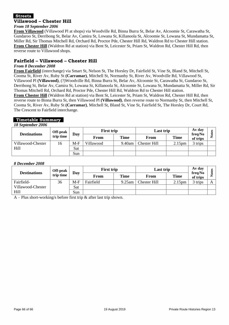
Page 66 of 66 19 August 2019 Private Route Histories Region 13
Streets
Villawood – Chester Hill From 18 September 2006 From Villawood (Villawood Pl at shops) via Woodville Rd, Binna Burra St, Belar Av, Alcoomie St, Carawatha St,
Gundaroo St, Derribong St, Belar Av, Camira St, Lowana St, Killanoola St, Alcoomie St, Lowana St, Mundamatta St,
Miller Rd, Sir Thomas Mitchell Rd, Orchard Rd, Proctor Pde, Chester Hill Rd, Waldron Rd to Chester Hill station.
From Chester Hill (Waldron Rd at station) via Bent St, Leicester St, Priam St, Waldron Rd, Chester Hill Rd, then
reverse route to Villawood shops.
Fairfield – Villawood – Chester Hill From 8 December 2008 From Fairfield (interchange) via Smart St, Nelson St, The Horsley Dr, Fairfield St, Vine St, Bland St, Mitchell St,
Cooma St, River Av, Ruby St (Carramar), Mitchell St, Normanby St, River Av, Woodville Rd, Villawood St,
Villawood Pl (Villawood), (?)Woodville Rd, Binna Burra St, Belar Av, Alcoomie St, Carawatha St, Gundaroo St,
Derribong St, Belar Av, Camira St, Lowana St, Killanoola St, Alcoomie St, Lowana St, Mundamatta St, Miller Rd, Sir
Thomas Mitchell Rd, Orchard Rd, Proctor Pde, Chester Hill Rd, Waldron Rd to Chester Hill station.
From Chester Hill (Waldron Rd at station) via Bent St, Leicester St, Priam St, Waldron Rd, Chester Hill Rd, then
reverse route to Binna Burra St, then Villawood Pl (Villawood), then reverse route to Normanby St, then Mitchell St,
Cooma St, River Av, Ruby St (Carramar), Mitchell St, Bland St, Vine St, Fairfield St, The Horsley Dr, Court Rd,
The Crescent to Fairfield interchange.
Timetable Summary 18 September 2006
Destinations Off-peak
trip time Day
First trip Last trip Av day
freq/No
of trips No
tes
From Time From Time
Villawood-Chester
Hill
16 M-F Villawood 9.40am Chester Hill 2.15pm 3 trips
Sat
Sun
8 December 2008
Destinations Off-peak
trip time Day
First trip Last trip Av day
freq/No
of trips No
tes
From Time From Time
Fairfield-
Villawood-Chester
Hill
36 M-F Fairfield 9.25am Chester Hill 2.15pm 3 trips A
Sat
Sun
A – Plus short-working/s before first trip & after last trip shown.