swiss style relief shading methodology:...
TRANSCRIPT

SWISS STYLE RELIEF SHADING METHODOLOGY: KNOWLEDGE BASE FOR FURTHER DEVELOPMENT AND
APPLICATION IN DIGITAL CARTOGRAPHY
Stefan Räber [email protected]
Bernhard Jenny
Lorenz Hurni [email protected]
Institute of Cartography, ETH Zurich
Wolfgang-Pauli-Strasse 15 CH-8093 Zurich, Switzerland
Abstract Relief shading is a method for representing the terrain in a natural, aesthetic, and intuitive manner. It is an important element of Swiss-style relief mapping, which combines contour lines, cliff drawing, relief shading and colors in accordance with an atmospheric perspective effect. This paper describes the basic principles of Swiss-style relief shading and introduces the website www.reliefshading.com. This web compendium covers all aspects of analogue and digital relief shading, and features many historical and contemporary examples. The website’s intent is to document the principles of Swiss-style relief shading and promote its use in contemporary mapping. 1. Introduction Terrain can be represented in many different ways, but Swiss-style relief shading is an efficient and visually attractive method to represent the third dimension of terrain on a two-dimensional map. This paper explains selected principles of Swiss-style relief shading and showcases selected examples. It also reports on www.reliefshading.com, a comprehensive, web-based compendium of relief shading, including detailed information about production techniques, design principles, use of colors, cartographers, the history and literature. The compendium not only covers analogue techniques, but also presents digital relief production, including software applications and digital workflows. This paper provides an overview of the information found on the website,
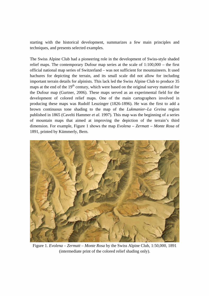
starting with the historical development, summarizes a few main principles and techniques, and presents selected examples. The Swiss Alpine Club had a pioneering role in the development of Swiss-style shaded relief maps. The contemporary Dufour map series at the scale of 1:100,000 – the first official national map series of Switzerland – was not sufficient for mountaineers. It used hachures for depicting the terrain, and its small scale did not allow for including important terrain details for alpinists. This lack led the Swiss Alpine Club to produce 35 maps at the end of the 19th century, which were based on the original survey material for the Dufour map (Gurtner, 2006). These maps served as an experimental field for the development of colored relief maps. One of the main cartographers involved in producing these maps was Rudolf Leuzinger (1826-1896). He was the first to add a brown continuous tone shading to the map of the Lukmanier–La Greina region published in 1865 (Cavelti Hammer et al. 1997). This map was the beginning of a series of mountain maps that aimed at improving the depiction of the terrain’s third dimension. For example, Figure 1 shows the map Evolena – Zermatt – Monte Rosa of 1891, printed by Kümmerly, Bern.
Figure 1. Evolena – Zermatt – Monte Rosa by the Swiss Alpine Club, 1:50,000, 1891
(intermediate print of the colored relief shading only).
2. Principles of Swiss-Style Relief Shading Fridolin Becker (1854-1922), professor at ETH Zurich, made important contributions to the development of Swiss style shading. To achieve the desired three-dimensional appearance of the shading, Becker applied the following principles (Schertenleib, 1997): - The map’s highest elevations are depicted by the brightest tones on the illuminated
sides and the darkest tones on the shadow sides. - The strength of the shading diminishes towards the valleys. - Instead of white, a medium tone is used for valley floors that visually connect the
two adjacent mountain slopes. - The highest mountain peaks must be depicted with the strongest color contrast.
Colors should be attenuated for lower areas to simulate the effect that aerial perspective has on colors. Color contrast must be reduced for the lowest terrain features (i.e. valley floors).
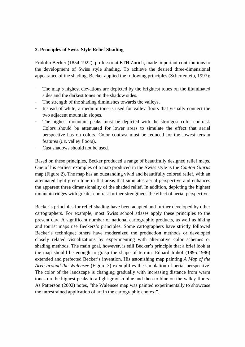
- Cast shadows should not be used. Based on these principles, Becker produced a range of beautifully designed relief maps. One of his earliest examples of a map produced in the Swiss style is the Canton Glarus map (Figure 2). The map has an outstanding vivid and beautifully colored relief, with an attenuated light green tone in flat areas that simulates aerial perspective and enhances the apparent three dimensionality of the shaded relief. In addition, depicting the highest mountain ridges with greater contrast further strengthens the effect of aerial perspective. Becker’s principles for relief shading have been adapted and further developed by other cartographers. For example, most Swiss school atlases apply these principles to the present day. A significant number of national cartographic products, as well as hiking and tourist maps use Beckers’s principles. Some cartographers have strictly followed Becker’s technique; others have modernized the production methods or developed closely related visualizations by experimenting with alternative color schemes or shading methods. The main goal, however, is still Becker’s principle that a brief look at the map should be enough to grasp the shape of terrain. Eduard Imhof (1895-1986) extended and perfected Becker’s invention. His astonishing map painting A Map of the Area around the Walensee (Figure 3) exemplifies the simulation of aerial perspective. The color of the landscape is changing gradually with increasing distance from warm tones on the highest peaks to a light grayish blue and then to blue on the valley floors. As Patterson (2002) notes, “the Walensee map was painted experimentally to showcase the unrestrained application of art in the cartographic context”.
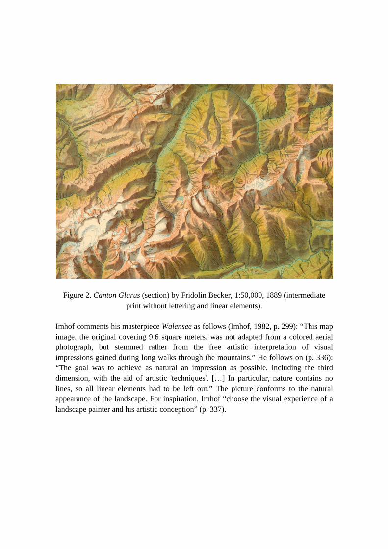
Figure 2. Canton Glarus (section) by Fridolin Becker, 1:50,000, 1889 (intermediate print without lettering and linear elements).
Imhof comments his masterpiece Walensee as follows (Imhof, 1982, p. 299): “This map image, the original covering 9.6 square meters, was not adapted from a colored aerial photograph, but stemmed rather from the free artistic interpretation of visual impressions gained during long walks through the mountains.” He follows on (p. 336): “The goal was to achieve as natural an impression as possible, including the third dimension, with the aid of artistic 'techniques'. […] In particular, nature contains no lines, so all linear elements had to be left out.” The picture conforms to the natural appearance of the landscape. For inspiration, Imhof “choose the visual experience of a landscape painter and his artistic conception” (p. 337).
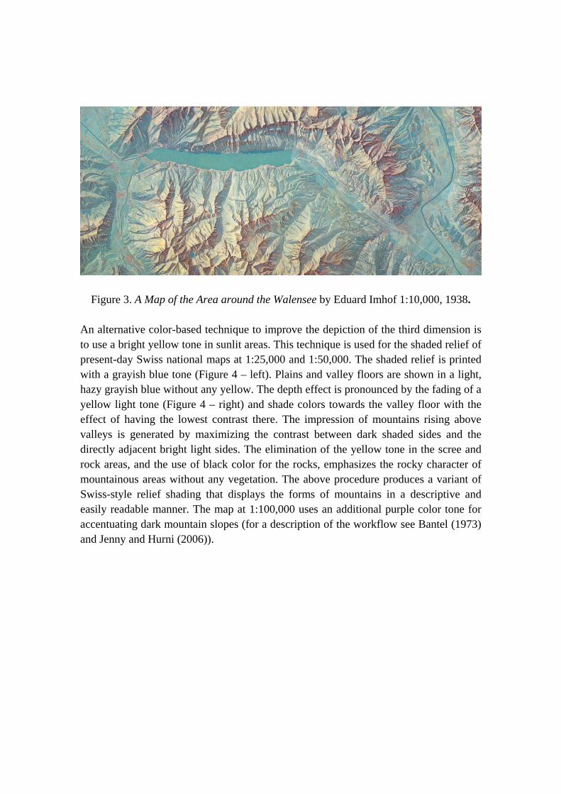
Figure 3. A Map of the Area around the Walensee by Eduard Imhof 1:10,000, 1938.
An alternative color-based technique to improve the depiction of the third dimension is to use a bright yellow tone in sunlit areas. This technique is used for the shaded relief of present-day Swiss national maps at 1:25,000 and 1:50,000. The shaded relief is printed with a grayish blue tone (Figure 4 – left). Plains and valley floors are shown in a light, hazy grayish blue without any yellow. The depth effect is pronounced by the fading of a yellow light tone (Figure 4 – right) and shade colors towards the valley floor with the effect of having the lowest contrast there. The impression of mountains rising above valleys is generated by maximizing the contrast between dark shaded sides and the directly adjacent bright light sides. The elimination of the yellow tone in the scree and rock areas, and the use of black color for the rocks, emphasizes the rocky character of mountainous areas without any vegetation. The above procedure produces a variant of Swiss-style relief shading that displays the forms of mountains in a descriptive and easily readable manner. The map at 1:100,000 uses an additional purple color tone for accentuating dark mountain slopes (for a description of the workflow see Bantel (1973) and Jenny and Hurni (2006)).
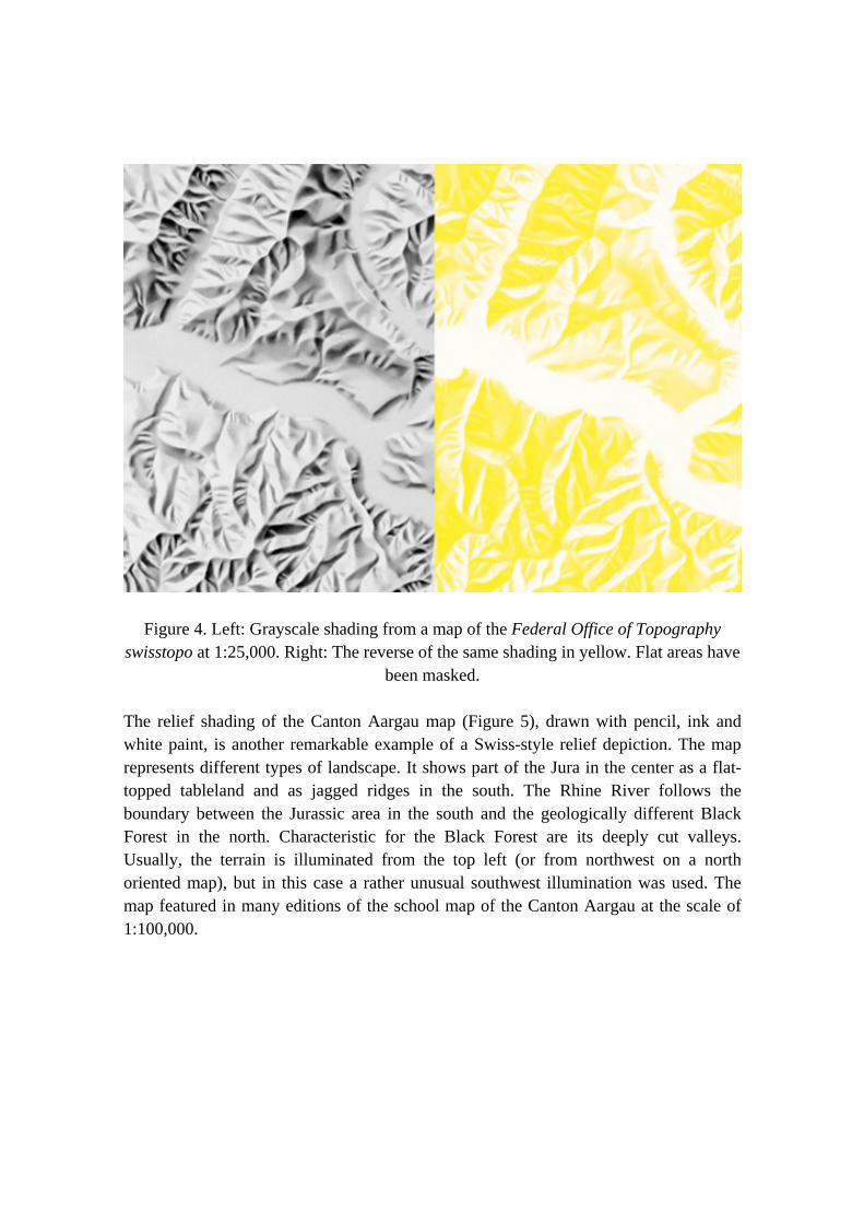
Figure 4. Left: Grayscale shading from a map of the Federal Office of Topography swisstopo at 1:25,000. Right: The reverse of the same shading in yellow. Flat areas have
been masked. The relief shading of the Canton Aargau map (Figure 5), drawn with pencil, ink and white paint, is another remarkable example of a Swiss-style relief depiction. The map represents different types of landscape. It shows part of the Jura in the center as a flat-topped tableland and as jagged ridges in the south. The Rhine River follows the boundary between the Jurassic area in the south and the geologically different Black Forest in the north. Characteristic for the Black Forest are its deeply cut valleys. Usually, the terrain is illuminated from the top left (or from northwest on a north oriented map), but in this case a rather unusual southwest illumination was used. The map featured in many editions of the school map of the Canton Aargau at the scale of 1:100,000.
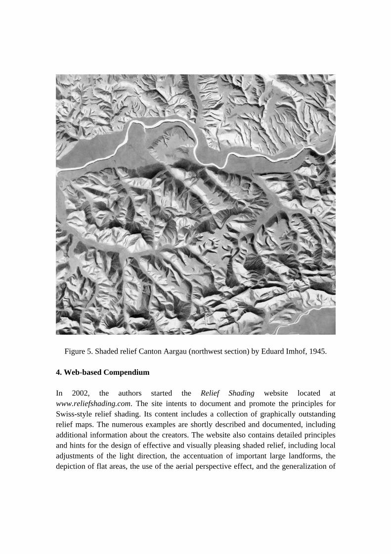
Figure 5. Shaded relief Canton Aargau (northwest section) by Eduard Imhof, 1945. 4. Web-based Compendium In 2002, the authors started the Relief Shading website located at www.reliefshading.com. The site intents to document and promote the principles for Swiss-style relief shading. Its content includes a collection of graphically outstanding relief maps. The numerous examples are shortly described and documented, including additional information about the creators. The website also contains detailed principles and hints for the design of effective and visually pleasing shaded relief, including local adjustments of the light direction, the accentuation of important large landforms, the depiction of flat areas, the use of the aerial perspective effect, and the generalization of

terrain for small scale relief shading. The most common production techniques are discussed, for example, digital shading algorithms, manual drawing, airbrushing, and the enhancement of digitally shaded relief with software tools, such as Adobe Photoshop. Furthermore, many software tools are presented for generating shaded relief from digital elevation models. The history chapter contains a historical overview, dealing with topics such as the development of the specific Swiss-style relief shading. The website also contains an extensive bibliography. The goal is to keep the website up to date, clearly structured and complete, with news and further information on relief shading. The authors would like to invite interested cartographers and map enthusiasts to participate in this project and contribute interesting material. 5. Conclusion Shaded relief is an efficient and visually attractive means to represent terrain on two-dimensional maps. The Relief Shading compendium at www.reliefshading.com compiles all relevant aspects and principles of relief shading techniques. It will hopefully further the use of shaded relief and help experienced and novice cartographers produce high-quality shaded relief. Software tools and digital elevation models are nowadays available to produce shaded relief in extremely short time and with a minimum of effort. The digital tools achieve similar or even better shaded relief than in the analogue era. The principles presented at www.reliefshading.com may help cartographers apply these tools effectively, and might even inspire the cartographic research community to develop new digital algorithms and methods that further improve digital relief shading by taking the well-proven principles into account. References Bantel, W. (1973). Der Reproduktionsweg vom einfarbigen Relieforiginal zur
mehrfarbigen Reliefkarte. In: International Yearbook of Cartography, ed. by Arnberger, E., and Aurada, F., 13, p. 133-136, Kartographisches Institut Bertelsmann, Gütersloh, Germany.
Cavelti Hammer, M., Feldmann, H.-U., and Oehrli, M. (1997). Farbe, Licht und Schatten. Die Entwicklung der Reliefkartographie seit 1660. Cartographica Helvetica, Murten, Switzerland.
Gurtner, M. (2008). The Swiss Alpine Club SAC and its role in national mapping. Proceedings of the 6th ICA Mountain Cartography Workshop, 11-15 Feb. 2008, Lenk, Switzerland, p.81-84. Online [accessed 8 July 2009]: http://www.mountaincartography.org/publications/papers/papers_lenk_08/gurtner.pdf
Hauri, R. (1997). Panoramen und Karten des Schweizer Alpen-Club. Verlag des SAC, Bern, Switzerland.
Imhof, E. (1982). Cartographic Relief Presentation. New York and Berlin: Walter de Gruyter.
Jenny, B., and Hurni L. (2006). Swiss-style colour relief shading modulated by elevation and by exposure to illumination. The Cartographic Journal, 43-3, p.198-207.
Jenny, B. and Räber, S. (2002). Relief Shading [online], Zürich, Institute of Cartography, ETH. Online [accessed 8 July 2009]: www.reliefshading.com
Patterson, T. (2002). Getting Real: Reflecting on the new look of National Park Service Maps. Proceedings of the 3rd ICA Mountain Cartography Workshop, Mt. Hood, Oregon, USA. Online [accessed 8 July 2009]: www.shadedrelief.com/realism/
Schertenleib, U. (1997). Fridolin Becker (1854-1922): Topograph, Kartograph, Innovator. Cartographica Helvetica, 15, p.3-10.