swan reach water filtration plant solar panel project · water filtration plant on murrraylands...
TRANSCRIPT

Page 1 of 56
Swan Reach Water Filtration Plant
Solar panel project
Data Report
Clearance under the Native Vegetation Regulations 2017 June 2019
Murraylands Road, Swan Reach
Prepared by T&M Ecologists

Page 2 of 56
Table of contents
1. Application information
2. Background
3. Method
3.1 Flora assessment
3.2 Fauna assessment
4. Assessment outcomes
1. Vegetation assessment
2. Requirements of the regulation
3. Mitigation hierarchy
5. Significant environmental benefit
Appendices
1. Bushland and Scattered Tree Vegetation Assessment Scoresheets (to be submitted in Excel format).
2. Representative photographs
3. Threatened ecological communities, flora and fauna species potentially occurring in the project area.

Page 3 of 56
1. Application information
Applicant: Aurecon Group
Key contact: Lauren Nicholson
Phone: 0478 550 440
Landowner: SA Water
Site Address: Murraylands Road, Swan Reach
Local Government
Area:
Mid Murray Council Hundred: Fisher
Certificate of Title:
CT 5526/308
CR/5421/423
CT 6053/327
CR 5362/713
CR 5362/714
Section/Allotment:
Section 3
Allotment 3 DP 6634
Allotment 4 DP 46634
Allotment 10 DP 29703
Allotment 11 DP 29703
Summary of Application
Proposed clearance
area:
11.06 hectares for solar panels and associated infrastructure (including 10m setback
distances from arrays to security fences).
A proposed clearance area of approximately 0.0258 hectares is required to allow for the
underground power route (electrical connections) to the south of the WTP (based on an impact area for trenching width of 2 metres, with a 0.5 loading for immediate site
rehabilitation). A proposed clearance area of approximately 0.002 hectares is required to allow for the
installation of power poles for the above ground powerline which is planned to the north
of the WTP.
Applicable
regulation and
purpose of the
clearance
Regulation 12(34) – Infrastructure
Level of risk 4
Proposed SEB offset: As this project is part of a comprehensive program of works that involves sites across
South Australia, SA Water proposes to pursue a suite of regionally based on-ground
offsets, through the establishment, regeneration or maintenance of native vegetation so
as to generate a net environmental gain to compensate for the residual impact of the
infrastructure. This program of offsets will be developed in consultation with the Native
Vegetation Unit of the Department of Environment and Water, and will aim to tailor the
offset activity on a regional basis so as to address the affected matter associated with
local clearances and/or address a regional conservation priority, if relevant.
Where residual impacts cannot be fully addressed by direct offsets, SA Water will apply
for payment into the Native Vegetation Fund, as required. A draft plan is currently being
developed by SA Water, and will be informed by the types of vegetation removed and
the amount of offset required.

Page 4 of 56
2. Background
2.1 Location and landuse This project involves the proposed installation of solar panels and associated infrastructure at the Swan Reach
Water Filtration Plant on Murrraylands Road at Swan Reach. See Figure 1 for location.
The existing SA Water infrastructure associated with the proposed development comprises the Swan Reach
Water Treatment Plant (WTP) and the first of the major pumping stations along the Swan Reach to Stockwell
Pipeline. The pipeline spans 54km from the Swan Reach Water Treatment Plant (WTP) where raw water is drawn
directly from the River Murray and is treated prior to it being pumped into the pipeline. The pipeline was built to
supply the Barossa Valley, Lower North and Yorke Peninsula areas and was first used in the 1960s, designed to
supplement existing water supply. The pipeline (and associated pump stations) serves townships and farm land
along its route, from Swan Reach on the Murray to Stockwell in the Barossa Valley, and also connects into the
Yorke Peninsula supply.
The Swan Reach Water Treatment Plant, an advanced water treatment plant built in 1998 for SA Water and
operated by Trility, is located just north of the township of Swan Reach on the Eastern Bank of the River Murray
and filters and treats the river water prior to it being pumped into the pipeline. The plant produces around
90ML/day and supplies approximately 32,000 customers. The Swan Reach PPS.1 pump station is one of four
major pump stations located on the River Murray below Lock 1 and pumps raw water from the river to the water
treatment plant.
Surrounding landuse is largely dryland agriculture. The River Murray is immediately adjacent to the east of the
proposed clearance area. Brookfield Conservation Park is located approximately 14km to the north-west and
Swan Reach Conservation Park is approximately 10km to the south-west.

Page 5 of 56
Figure 1: Location of proposed solar panel installation, Swan Reach Wastewater Treatment Plant

Page 6 of 56
A total area of approximately 10.8 hectares to the north of the wastewater treatment plant was assessed in
January 2019. Additional locations (8.778 hectares in total) were assessed in April 2019 to encompass the
required electrical cabling route, as well as an additional solar PV installation area south of the treatment
lagoons.
A broad area was surveyed for the electrical cabling route as the exact path this would take (for both the
northern and southern array connections) is not yet confirmed, pending information on geotechnical constraints.
However there is indicative agreement that the southern power route will require underground trenching, while
the northern route will likely comprise an overhead line (see Figure 2).
Figure 2: Areas assessed in January 2019 are highlighted in blue. Additional areas assessed in April 2019 are
shown with yellow outline.
Figure 3 shows the solar array areas and associated electrical cable routes. The northern power route (approx. 375
metres long) will likely be an above-ground cable, where the main clearance is limited to the associated power pole
bases, though a 10m wide easement will also be applied to this route, however it is unlikely that any clearance/
vegetation management will be required to ensure the electrical route is accessible for maintenance purposes due to
the low-lying nature of the vegetation. The southern cable route (approx. 350 metres long) will be an underground
easement, with a trenching width of 1-2 metres required. After the underground cable is laid, vegetation will be able
to regenerate within the route.

Page 7 of 56
Figure 3: Shows the solar array areas (blue outline) and associated electrical cable routes (dashed black
line). Note that the cable route is proposed to be above ground (overhead) in the northern half and
underground in the southern half.
2.2 Approvals required or obtained under other legislation (including past clearance approvals) The proposed installation of solar PV arrays and associated infrastructure is presently under assessment by the State
Commission Assessment Panel (SCAP) as a Crown Development and Public Infrastructure application, in accordance
with Section 49 of the Development Act 1993.
As part of the assessment process, the application was referred for comment to the Mid Murray Council, Native
Vegetation Council, Minister for the River Murray and the SA Murray-Darling Basin NRM Board with no objections or
requests for further information having been received.
3. Method
3.1 Flora assessment
Vegetation data was gathered using DEW’s Bushland Assessment methodology and Scattered Tree Assessment
methodology1.
1 Native Vegetation Management Unit, Department of Environment and Water, 2017.

Page 8 of 56
3.2 Fauna assessment
3.2.1 Database searches for flora and fauna
Results from the on-site assessment were supplemented with searches within a 5-10 kilometre buffer of the
boundaries of the survey area using the following resources:
South Australian Department of Environment and Water (DEW) Biological Database of South Australia
(BDBSA) search2within a 10km radius;
Nature Maps3(5km radius); and
Department of Environment and Energy (DoEE) Protected Matters Search Tool (PMST)4 (5km radius).
3.2.2 Southern Hairy-nosed Wombat
As a number of active and disused Southern Hairy-Nosed Wombat (Lasiorhinus latifrons) burrows and warrens have
been identified within the proposed solar PV installation area, SA Water’s construction partner has engaged the
services of Shimmin Environmental Consultants to undertake a survey of the burrows and provide mapping to
determine the full extent of these burrows and therefore what exclusionary areas should be factored into final
designs to minimise impact upon the wombat population, as well as to ensure the structural adequacy of the solar PV
arrays. It is expected that this survey will be undertaken within the next month and results will then be used to finalise
the layout of the solar PV array. The findings will also be provided to the Native Vegetation Unit.
As part of this field assessment, undertaken in January and April 2019, active and disused warrens and burrows were
recorded and mapped (see Figure 2 for locations). However, this was not a comprehensive survey.
4. Assessment Outcomes
4.1 Vegetation Assessment
The assessment area directly to the north of the Swan Reach Water Filtration Plant (WTP) occurs on Crown Reserve
land within Allotment 3 D6634, Hundred of Fisher. This northern site has been divided into ‘Area 1’ (north) and ‘Area
2’ (south) which are separated by a track/roadway that provides access from Murraylands Road to a property on the
adjacent floodplain.
Assessment areas to the south and east of the WTP are within Allotment 4 D46634, Allotment 10 D29703 and
Allotment 11 D29703, Hundred of Fisher.
A total of 8 separate native vegetation communities were assessed and the Bushland Assessment Summary
Scoresheets are included in Appendix 1 and representative photographs in Appendix 2. There is also an area of
*Pinus halepensis (Community 9) which is shown on Figure 4 but was not assessed as a native vegetation community.
These communities are shown on Figure 4 and are described as follows:
1. False Sandalwood (Myoporum platycarpum) Low open woodland
A small patch (0.3626ha) of woodland occurs towards the south-eastern end of Area 2. The understorey is
dominated by Bitter Saltbush (Atriplex stipitata) and Spine Bush (Acacia nyssophylla). There is evidence of
heavy grazing throughout with widespread signs of wombats (diggings and scats). Rabbits and kangaroos
are also present and impacting on native vegetation.
Fifteen native plant species were observed in this vegetation type. Native:exotic understorey biomass was
estimated to be 81-90%, however trees are in poor health overall and no hollows were noted. Fallen timber
was sparse and bare ground was estimated to be 5-10%.
2 Department of Environment and Natural Resources, Biological Databases of SA (BDSA). This data has been sourced from the South Australian Department of Environment, Water and Natural Resources Biological Database of SA. Recordset number 3 http://spatialwebapps.environment.sa.gov.au/naturemaps 4 Australian Government (2018). http://www.environment.gov.au/epbc/protected-matters-search-tool accessed 21/11/2018.

Page 9 of 56
2. Senna spp. +/- Spine Bush (Acacia nyssophylla) Shrubland over Bitter Saltbush (Atriplex stipitata)
with widely scattered emergent False Sandalwood (Myoporum platycarpum).
This community occurs across both Area 1 and Area 2 and covers approximately 4.0168ha. There is
evidence of heavy grazing throughout with widespread signs of wombats, including diggings and scats.
Thirteen native plant species were observed in this vegetation type. Native:exotic understorey biomass was
estimated to be 81-90% and bare ground was estimated to be 5-10%.
A row of planted Southern Cypress Pine (Callitris gracilis) occur adjacent to Murraylands Road on the
northern half of the north-west boundary of Area 2. Also, a row of planted Aleppo Pine (*Pinus halepensis)
occur adjacent to Murraylands Road towards the more southern half of Area 1.
3. Bitter Saltbush (Atriplex stipitata) Low open shrubland with emergent Senna spp. and Spine Bush
(Acacia nyssophylla).
This community is the most widespread (approximately 5.6727ha) and occurs in more degraded parts across
both Area 1 and Area 2. There is evidence of heavy grazing throughout with widespread signs of wombats,
including diggings, scats and both active and disused warrens (see Figure 2 for locations). Weed cover in this
community is also higher due to its more open and disturbed nature.
Eight native plant species were observed in this vegetation type. Native:exotic understorey biomass was
estimated to be 61-70%, and bare ground was estimated to be 11-20%.
A row of planted and irrigated trees (*Schinus sp.?) occur along the north-eastern boundary of Area 1.
4. Bitter Saltbush (Atriplex stipitata) Low open shrubland with emergent Spine Bush (Acacia
nyssophylla) and Sticky Hop-bush (Dodonaea viscosa ssp.)
This community occurs across large tracts of the more northern block and is approximately 4.977 hectares
in area. There is evidence of heavy grazing throughout with widespread signs of wombats (diggings, scats,
grazing, active burrows and warrens). A total of 12 native plant species was observed in this vegetation
type.
The impact on this community is likely to be negligible because the only infrastructure proposed in this
location is an overhead powerline. There will be up to 10 power poles installed, each of requires the
clearance of a 2.4m wide x 1.02m long (2.45 metres2) footing ‘pad’. A total clearance area of approximately
0.00245 hectares has therefore been estimated to allow for the installation of power poles. A reduction
has been applied to allow for rehabilitation of the site post-construction. It is unlikely that any ongoing
maintenance trimming will be required beneath the powerline due to the low-lying nature of the
vegetation.
5. Sticky Hop-bush (Dodonaea viscosa ssp.) +/- Spine Bush (Acacia nyssophylla) Shrubland with widely
scattered emergent False Sandalwood (Myoporum platycarpum) and Umbrella Wattle (Acacia oswaldii).
Two small patches of this community occur in the more northern block, covering a total area of
approximately 0.2418 hectares. There is evidence of heavy grazing throughout with widespread signs of
wombats, including diggings and scats. Thirteen native plant species were observed in this vegetation type.
The impact on this community is likely to be negligible because the only infrastructure proposed in this
location is an overhead powerline. It is unlikely that any ongoing maintenance trimming will be required
beneath the powerline due to the low-lying nature of the vegetation.
6. Broad-leaf Desert Senna (Senna artemisioides x coriacea) +/- Spine Bush (Acacia nyssophylla)
Shrubland with emergent False Sandalwood (Myoporum platycarpum).
This community occurs in the western third and covers approximately 1.0406 hectares in total area, with an
area of impact of 0.483 hectares. A total of 15 native plant species was observed in this vegetation type.
No wombat warrens or burrows were observed in this area and the vegetation is in better condition than
other parts of the assessment area.

Page 10 of 56
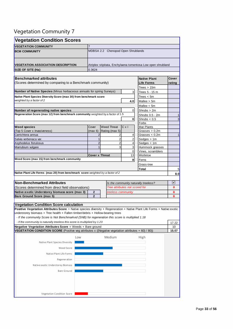
7. Bitter Saltbush (Atriplex stipitata), Ruby Saltbush (Enchylaena tomentosa) Low open shrubland
Occurs across a total assessed area of approximately 1.599 hectares of the southern block. Areas of impact
are 0.3447 hectares for solar panels and 0.0177 hectares for below ground powerline (this is based on an
impact area for trenching width of 2 metres, with a 0.5 loading for immediate site rehabilitation).
A total of 3 native plant species was recorded in this vegetation type which has evidence of wombat
grazing/damage. Bare ground was estimated to be 21-30%.
8. Spine Bush (Acacia nyssophylla) Open shrubland with emergent False Sandalwood (Myoporum
platycarpum)
Occurs across a total assessed area of approximately 0.9197 hectares at the north-eastern end of the
southern block, with an area of impact of 0.1881 hectares for solar panels and 0.0081 hectares for below
ground powerline (based on an impact area for trenching width of 2 metres, with a 0.5 loading for
immediate site rehabilitation).
A total of 5 native plant species was recorded in this vegetation type which has evidence of wombat
grazing/damage. Bare ground was estimated to be 21-30%.
Three (3) scattered River Red Gums (Eucalyptus camaldulensis ssp. camaldulensis) were also assessed as they are
situated within the boundary of the proposed clearance envelope (Figure 2). While the River Red Gums were
included in the broader survey area, it has since been confirmed by SA Water’s construction partner that the
associated power easement which is to connect the northern array to the pump station connection point will
follow a route further up the bank to avoid these trees and the steeper terrain.

Page 11 of 56
Figure 4: Vegetation communities and wombat warrens/burrows mapped as part of this assessment.

Page 12 of 56
4.2 Database search results
A search of various databases and other sources (Section 3.2.1) was undertaken and threatened vegetation
communities and threatened flora and fauna species which have been recorded within a 5-10km radius of the site
are listed in Appendix 3 which includes comments on the likelihood that these communities/species would occur
within the project area.
4.3 Requirements of the Regulation
Provide information on how the proposed clearance meets the requirements of the regulation.
i. Identify the regulation under which the proposed clearance is applicable and demonstrate that it
meets all the criteria of the regulation contained in Division 5 and Schedule 1
The proposed clearance is being undertaken under Regulation 12(34) – Infrastructure. This Regulation is to
allow clearance of vegetation incidental to the construction or expansion of a building or infrastructure (and
associated services) where the Minister has declared that the clearance is in the public interest.
ii. Risk Assessment - determine the level of risk and provide information to support the risk
assessment– see Guide for Applications to Clear Native Vegetation
Under the risk assessment pathway, as part of the Native Vegetation Regulations, two considerations will be
applied to assess the risk to biodiversity conservation of a proposed clearance:
1. the size of the clearance (area of clearance or number of trees to be cleared); and
2. the presence of threatened species or communities (representing principles b,c and d of the
‘Principles of Clearance’, Native Vegetation Act 1991).
In this instance, the level of risk has been identified as Level 4 because the proposed areas of clearance have
a Total Biodiversity Score of greater than 250. The relevant Principles are addressed below, with reference to data gathered within the proposed clearance area.
b. the vegetation has significance as habitat for wildlife
The Protected Matters Search Tool (PMST) search (5km radius) listed 7 fauna species with a Type of
Presence of “Species or species habitat known to occur within area”5. These are:
Southern Bell Frog (Litoria raniformis)
Greater Bilby (Macrotis lagotis)
Common Sandpiper (Actites hypoleucos)
Great Egret (Ardea alba)
Sharp-tailed Sandpiper (Calidris acuminata)
Pectoral Sandpiper (Calidris melanotos)
White-bellied Sea Eagle (Haliaeetus leucogaster)
It is considered that the project area is not providing significant habitat for any of these species (see
Appendix 3 for details).
A search of NatureMaps within a 5km radius listed 3 threatened fauna species:
Southern Bell Frog (Litoria raniformis)
Broadshelled Turtle (Chelodina expansa)
5 As per guideline provided in the “Native Vegetation Council (NVC) Bushland Assessment Manual”.

Page 13 of 56
Macquarie River Turtle (Empydura macquarii)
It is considered that the project area is not providing significant habitat for any of these species (see
Appendix 3 for details).
A search of the Biological Database of South Australia (BDBSA) listed one bird species of State
conservation significance which has been recorded in similar habitat within a 10km radius of the site -
Gilbert’s Whistler, Pachycephala inornata, rated Rare in South Australia. This species may possibly utilize
Community 1 – Myoporum platycarpum Low woodland.
Using the Bushland Assessment scoring, the “Guide for applications to clear native vegetation”6 provides
the following criteria for assessment against this Principle:
Threatened Fauna Score At Variance with the Principles
0 Not at variance
<0.05 At variance
>0.05 Seriously at variance
Or
A vegetation association with a Unit Biodiversity Score of >60 Seriously at variance
Table 2 assesses the vegetation present across the proposed clearance site against this Principle, using the
above criteria.
Table 2: Assessment of vegetation communities as a habitat for wildlife using NVC criteria
Site/Vegetation Community Threatened fauna present or may be present
Threatened fauna score
Unit Biodiversity Score
Assessment against Principle b
1. Myoporum platycarpum Low open woodland 1 State Rare species
0.02 59.65 At variance
2. Senna spp. +/- Acacia nyssophylla Shrubland over Atriplex stipitata with very scattered emergent Myoporum platycarpum
Nil 0 62.61 Seriously at variance
3. Atriplex stipitata Low open shrubland with scattered emergent Acacia nysophylla and Senna spp.
Nil 0 29.45 Not at variance
4. Bitter Saltbush (Atriplex stipitata) Low open shrubland with emergent Spine Bush (Acacia nyssophylla) and Sticky Hop-bush (Dodonaea viscosa ssp.)
Nil 0 28.75 Not at variance
5. Sticky Hop-bush (Dodonaea viscosa ssp.) +/- Spine Bush (Acacia nyssophylla) Shrubland with widely scattered emergent False Sandalwood (Myoporum platycarpum) and Umbrella Wattle (Acacia oswaldii).
Nil 0 - Not at variance
6. Broad-leaf Desert Senna (Senna artemisioides X coriacea) +/- Spine Bush (Acacia nyssophylla) Shrubland with emergent False Sandalwood (Myoporum platycarpum).
Nil 0 56.94 Not at variance
7. Bitter Saltbush (Atriplex stipitata), Ruby Saltbush Low open shrubland
Nil 0 17.18 Not at variance
6 Native Vegetation Council (2017). Guide for applications to clear native vegetation under the Native Vegetation Act 1991 and Native Vegetation Regulations 2017. Department for Environment, Water and Natural Resources, Adelaide.

Page 14 of 56
Site/Vegetation Community Threatened fauna present or may be present
Threatened fauna score
Unit Biodiversity Score
Assessment against Principle b
8. Spine Bush (Acacia nyssophylla) Open shrubland with emergent False Sandalwood (Myoporum platycarpum)
Nil 0 30.71 Not at variance
The proposed clearance is therefore not at variance with Principle b for Communities/Sites 3-8. Although
Community 1 has been assessed as being ‘At variance’ with Principle b, it is considered to be a very small
and heavily grazed area, therefore its proposed clearance would not be likely to have a significant impact
on this species.
Community 2 has been assessed as being ‘Seriously at variance’ with Principle b because it has a Unit
Biodiversity Score of 62.61, however Acacia nyssophylla is considered to be an increaser species in this
region and, as this spiny species is highly unpalatable, it is not readily grazed and it increases while other
more palatable species decrease through grazing7. This area, which has been heavily grazed over a long
period, is considered to have a decreased structural diversity, with native grasses, herbaceous species and
understorey small shrubs greatly reduced in number and cover. Therefore, the proposed clearance of
Community 2 has been tempered to “at variance” with Principle b.
c. the site includes plants of a rare, vulnerable or endangered species
The Protected Matters Search Tool (PMST) search (5km radius) did not list any flora species with a Type of
Presence of “Species or species habitat known to occur within area”8. (See Appendix 3 for details.)
A search of Nature Maps within a 5km radius listed 9 threatened flora species (see Appendix 3 for details).
However, none of these species were recorded during the field assessments and, given the degraded
nature of the project area, it is considered that none of these species are likely to occur.
A search of the Biological Database of South Australia (BDBSA) listed a further 21 threatened flora species
which have been recorded within a 10km radius. Only one of these species, the State Rare Rohrlach’s
Bluebush (Maireana rohrlachii), was recorded during the field survey. This species was found in
Community 1, Community 4 and Community 6.
Using the Bushland Assessment scoring, the “Guide for applications to clear native vegetation”9 provides
the following criteria for assessment against this Principle:
Threatened Fauna Score At Variance with the Principles
0 Not at variance
<0.05 At variance
>0.05 Seriously at variance
Table 3 assesses the vegetation present across the proposed clearance site against this Principle.
7 Croft, SJ, Pedler, JA & Milne, TI (2009). Bushland Condition Monitoring Manual: Murray Darling Basin South Australia, Nature Conservation Society of South Australia Inc., July 2009. 8 As per guideline provided in the “Native Vegetation Council (NVC) Bushland Assessment Manual”. 9 Native Vegetation Council (2017). Guide for applications to clear native vegetation under the Native Vegetation Act 1991 and Native Vegetation Regulations 2017. Department for Environment, Water and Natural Resources, Adelaide.

Page 15 of 56
Table 3: Assessment of vegetation communities as including threatened flora species using NVC criteria
Site/Vegetation Community Threatened fauna present or may be present
Threatened flora score
Assessment against Principle c
1. Myoporum platycarpum Low open woodland 1 State Rare species
0.02 At variance
2. Senna spp. +/- Acacia nysophylla Shrubland over Atriplex stipitata with very scattered emergent Myoporum platycarpum
Nil 0 Not at variance
3. Atriplex stipitata Low open shrubland with scattered emergent Acacia nysophylla and Senna spp.
Nil 0 Not at variance
4. Bitter Saltbush (Atriplex stipitata) Low open shrubland with emergent Spine Bush (Acacia nyssophylla) and Sticky Hop-bush (Dodonaea viscosa ssp.)
1 State Rare species
0.02 At variance
5. Sticky Hop-bush (Dodonaea viscosa ssp.) +/- Spine Bush (Acacia nyssophylla) Shrubland with widely scattered emergent False Sandalwood (Myoporum platycarpum) and Umbrella Wattle (Acacia oswaldii).
Nil 0 Not at variance
6. Broad-leaf Desert Senna (Senna artemisioides X coriacea) +/- Spine Bush (Acacia nyssophylla) Shrubland with emergent False Sandalwood (Myoporum platycarpum).
1 State Rare species
0.02 At variance
7. Bitter Saltbush (Atriplex stipitata), Ruby Saltbush Low open shrubland
Nil 0 Not at variance
8. Spine Bush (Acacia nyssophylla) Open shrubland with emergent False Sandalwood (Myoporum platycarpum)
Nil 0 Not at variance
The clearance which is proposed in Community 2, Community 3, Community 5, Community 7 and
Community 8 is therefore ‘Not at variance’ with Principle c.
The clearance which is proposed in Community 1, Community 4, and Community 6 is ‘At variance with
Principle c’. However, given the highly degraded and over-grazed condition of the vegetation, it is unlikely
that clearance of a small number of Maireana rohrlachii individuals will lead to a long-term decrease in the
size of the population overall.
d. the vegetation comprises the whole, or a part, of a plant community that is Rare, Vulnerable or
Endangered
No plant communities of State or National conservation significance were recorded during the site
assessment. The proposed clearance is therefore not at variance with Principle d.
4.4 Address the Mitigation Hierarchy
The NVC will assess the measures taken to avoid and minimize impacts on biodiversity and rare or threatened species
or ecological communities within the property or immediate vicinity of the development.
Demonstrate how the clearance proposal addresses the following:

Page 16 of 56
a) Avoidance – outline measures taken to avoid clearance of native vegetation such as making adjustments
to the location, design, size or scale of the activity in order to reduce the impact.
Construction works proposed at this site forms part of a larger program involving the installation of solar panels
and battery storage at over 70 high energy-use SA Water sites around the state of South Australia. To deliver
‘behind-the-meter generation’, these installations have to be as close as reasonably practicable to the point of
connection. During project development SA Water has taken measures to prioritise sites that are either already
cleared of vegetation or have degraded vegetation present, and avoid areas of high quality intact native
vegetation. In addition, SA Water has taken measures to maximise installations at sites with high network
capacity and low environmental impact aspects (such as native vegetation or heritage), thereby avoiding impacts
at other sites.
The solar PV installation proposed at the Swan Reach Water Filtration Plant and Pump Station No.1 is one of
three such installations planned along the Swan Reach to Stockwell Pipeline. At the third pump station along this
pipeline, approximately 32km to the west in the area of Truro, it was previously proposed that approximately 6
hectares of land within the property at Q97, FP200136 Hundred of Jellicoe (Pipeline Road, Truro) would
accommodate solar PV arrays and a native vegetation survey was undertaken here in November 2018. The
undertaking of this survey found mature remnant Peppermint Box (Eucalyptus odorata) trees containing multiple
hollows and observed to be regenerating following previous bushfires.
The mature Peppermint Box trees were noted as likely providing important habitat for several threatened bird
species including the White-winged Chough, Diamond Firetail and Hooded Robin (South East ssp.) which have
been recorded within similar habitat within a 5km radius of the assessment site. These factors contributed to a
high overall Biodiversity Score (290.08) which was not considered an acceptable outcome for the Zero Cost
Energy Future project and this site has since been removed from the program, placing even greater importance
upon the ability of all remaining sites to generate commensurate power outputs required to achieve net zero
energy usage. The proposed location at Swan Reach WFP and PPS.1 is considered appropriate as this location
exhibits overall lesser quality vegetation communities which are not considered to provide significant habitat for
threatened fauna species
b) Minimization – if clearance cannot be avoided, outline measures taken to minimize the extent, duration
and intensity of impacts of the clearance on biodiversity to the fullest possible extent.
In finalising the design of the solar installation, SA Water will seek to minimise the clearance of native vegetation
by utilising existing vehicle access tracks where possible, retaining any vegetation present in a 10m buffer
around the site boundary and designing solar panel layout to maximise the amount placed in vegetation
associations with a lower Unit Biodiversity Score (i.e. place infrastructure in areas of poorer quality vegetation
over higher quality vegetation).
Where possible within the site, native grasses and groundcovers will be retained, however once installed, the
panel arrays will likely cause a reduction in cover of native groundcovers due to shading. In addition, a ‘Site
Specific Environmental Control Plan’ will be required for the construction phase to manage any native
vegetation and ensure only vegetation approved for removal is cleared. Compliance with the plan will be
monitored and audited during the works, and a final audit of the remaining native vegetation and its condition
will be done at completion of works. Appropriate design and site positioning will be reviewed in the detailed
design stage to minimise the overall clearance of vegetation required.
c) Rehabilitation or restoration – outline measures taken to rehabilitate ecosystems that have been
degraded, and to restore ecosystems that have been degraded, or destroyed by the impact of clearance
that cannot be avoided or further minimized, such as allowing for the re-establishment of the vegetation.
At all sites, perimeter fencing will be installed around the solar array that will exclude grazing by livestock and
other herbivores, thereby enabling recovery of any remnant native vegetation within the site. Solar panels will be
set back 10 metres from the perimeter providing opportunity for SA Water to undertake, where possible, infill
planting of appropriate native species of local provenance to enhance screening functions and support local

Page 17 of 56
biodiversity. SA Water has instructed the appointed construction contractor to utilise slashing or mowing
techniques, as opposed to a blanket clearing or grading of the development area (which would leave bare earth)
to allow for the vegetation with lower height profiles to regenerate post construction. Vegetation of greater
height (trees/ large shrubs) will likely need to be entirely removed from the development area as they pose a
risk to the solar arrays if they re-grow to pre-construction heights. The removed vegetation material would be
retained on site for potential use as ‘habitat stacks’. These methods will be confirmed within final design details
and regulated through the Site Specific CEMP.
d) Offset – any adverse impact on native vegetation that cannot be avoided or further minimized should be
offset by the achievement of a significant environmental benefit that outweighs that impact.
As this project is part of a comprehensive program of works that involves sites across South Australia, SA Water
proposes to pursue a suite of regionally based on-ground offsets, through the establishment, regeneration or
maintenance of native vegetation so as to generate a net environmental gain to compensate for the residual
impact of the infrastructure on region-by-region basis. This program of offsets will be developed in consultation
with the Native Vegetation Unit of the Department of Environment and Water, and will aim to tailor the offset
activity on a regional basis so to address the affected matter associated with local clearances and/or address a
regional conservation priority if relevant. SA Water intends to pool offset activity into one or more larger sites
within each region so as to maximise habitat values and minimise edge effects. Where residual impacts cannot
be fully addressed by direct offsets, SA Water will apply for payment into the native Vegetation Fund as
required. A draft plan is currently being developed by SA Water, and will be informed by the types of vegetation
removed and the amount of offset required in each region.
5. Significant Environmental Benefit
A Significant Environmental Benefit (SEB) is required for approval to clear under Division 5 of the Native Vegetation
Regulations 2017. The NVC must be satisfied that as a result of the loss of vegetation from the clearance that an SEB
will result in a positive impact on the environment that is over and above the negative impact of the clearance.
The Data Report must propose how the SEB will be achieved in accordance with the SEB Policy and Guide, by
providing the following information.
DETERMINATION OF THE SEB OBLIGATION
Table 4 summarises the assessment outcomes for the proposed area of impact assessed using the Bushland
Assessment Method. See Appendix 1 for the Bushland Assessment Scoresheets.
Table 4: Summary of Bushland Assessments
Vegetation
Community
Area (ha) of
proposed impact
Unit Biodiversity Score Total Biodiversity
Score
SEB Points required
1 0.3626 59.65 21.63 22.71
2 4.0168 62.61 251.48 264.06
3 5.6727 29.45 167.04 175.39
4 .00245 28.75 0.07 0.05
5 - - - -
6 0.4830 56.94 27.5 28.88
7 0.3624 17.18 6. 22 6.54
8 0.1962 30.71 6.02 6.33
ACHIEVING AN SEB
Indicate how the SEB will be achieved by ticking the appropriate box:
Establish a new SEB Area on land owned by the proponent. Provide information below.

Page 18 of 56
Use SEB Credit that the proponent has established. Provide the SEB Credit Ref. No. ___________
Apply to have SEB Credit assigned from another person or body. The application form needs to be
submitted with this Data Report.
Apply to have an SEB to be delivered by a Third Party. The application form needs to be submitted with
this Data Report.
Pay into the Native Vegetation Fund
FOR AN ON-GROUND SEB
As this project is part of a comprehensive program of works that involves sites across South Australia, SA Water
proposes to pursue a suite of regionally based on-ground offsets, through the establishment, regeneration or
maintenance of native vegetation so as to generate a net environmental gain to compensate for the residual impact
of the infrastructure on a region-by-region basis.
This program of offsets will be developed in consultation with the Native Vegetation Unit of the Department of
Environment and Water, and will aim to tailor the offset activity on a regional basis so to address the affected matter
associated with local clearances and/or address a regional conservation priority if relevant. SA Water intends to pool
offset activity into one or more larger sites within each region so as to maximise habitat values and minimise edge
effects. Where residual impacts cannot be fully addressed by direct offsets, SA Water will apply for payment into the
native Vegetation Fund as required. A draft plan is currently being developed by SA Water, and will be informed by
the types of vegetation removed and the amount of offset required in each region.
FOR A PAYMENT SEB
If a proponent is unable to provide an on ground SEB, a proponent may choose, subject to meeting certain
requirements as described in the SEB Policy, to make a payment into the Native Vegetation Fund in lieu of providing
an on ground SEB10.
Table 6 provides indicative values for a cash offset for clearance of the different vegetation types within the
assessment site.
10 Native Vegetation Council (2016). Guide for calculating a Significant Environmental Benefit Under the Native Vegetation Act 1991 and Native Vegetation Regulations 2017. Government of South Australia, Adelaide.

Page 19 of 56
Table 6: Cash offset values for the proposed clearance
Area Unit
Biodiversity
Score
Payment
Required (GST
exclusive)
Administration Fee
(GST inclusive)
1 59.65 $7,523.07 $413.77
2 62.61 $87,469.54 $4,810.82
3 29.45 $58,098.41 $3,195.41
4 28.75 $17.15 $0.94
5 - - -
6 56.94 $9,565.81 $526.12
7 17.18 $2,165.11 $119.08
8 30.71 $2,095.55 $115.26

Page 20 of 56
Appendix 1: Bushland Assessment Scoresheets
Note that only the Site Scoresheets have been included here – the full set of sheets which also includes the ‘Block’, ‘Flora’ and ‘Fauna’ sheets
will be uploaded to the NVC portal at the time of application lodgement.

Page 21 of 56
Vegetation Community 1
Vegetation Condition Scores
VEGETATION COMMUNITY
BCM COMMUNITY
VEGETATION ASSOCIATION DESCRIPTION
SIZE OF SITE (Ha)
Benchmarked attributes Native Plant Cover
(Scores determined by comparing to a Benchmark community) Life Forms rating
Trees > 15m
Number of Native Species (Minus herbaceous annuals for spring Surveys) 15 Trees 5 - 15 m 2
Native Plant Species Diversity Score (max 30) from benchmark score Trees < 5m 3
weighted by a factor of 2 24.0 Mallee > 5m
Mallee < 5m
Number of regenerating native species 2 Shrubs > 2m 1
Regeneration Score (max 12) from benchmark community weighted by a factor of 1.5 Shrubs 0.5 - 2m 3
6 Shrubs < 0.5 3
Forbs
Weed species Cover C x I Mat Plants
(Top 5 Cover x Invasiveness) (max 6) Grasses > 0.2m
Carrichtera annua 1 2 Grasses < 0.2m 1
Asphodelus fistulosus 1 2 Sedges > 1m
Romulea sp. 1 2 Sedges < 1m
0 Hummock grasses
0 Vines, scramblers
6 Mistletoe 1
Weed Score (max 15) from benchmark community 12 Ferns
Grass-tree
Total 14
Native Plant Life Forms (max 20) from benchmark score weighted by a factor of 2 18.0
42
Non-Benchmarked Attributes Is the community naturally treeless? FALSE
(Scores determined from direct field observations) Tree Health Score (max 5) 3
Native:exotic Understorey biomass score (max 3) 3 Fallen timber/debris (max 5) 0
Bare Ground Score (max 5) 4 Hollow-bearing trees Score (max 5) 0
Vegetation Condition Score calculationPositive Vegetation Attributes Score = Native species diversity + Regeneration + Native Plant Life Forms + Native:exotic
- If the community Score is Not Benchmarked (SNB) for regeneration this score is multiplied 1.18
- If the community is naturally treeless this score is multiplied by 1.23 54.00
Negative Vegetation Attributes Score = Weeds + Bare ground 16
51.30
Maximum score 1 0
Vegetation Condition Score0.64125 0
Fallen timber 0 1
Tree Hollows 0 1
Tree Health 0.6 0
Bare Ground 0.8 0
Native:exotic Understorey Biomass1 0
Regeneration 0.5 1
Native Plant Life Forms0.9 0
Weed Score 0.8 0
Native Plant Species Diversity0.8 0
1
MDBSA 1.1 Open Woodland with Open Arid adapted Shrub
Understorey on Limestone Plains
Myoporum platycarpum Low open woodland
0.3626
Weed Threat
Rating (max 5)
2
2
2
understorey biomass + Tree health + Fallen timber/debris + Hollow-bearing trees
VEGETATION CONDITION SCORE (Positive veg attributes x ((Negative vegetation attributes + 60) / 80))
Cover x Threat
Vegetation Condition Score
Fallen timber
Tree Hollows
Tree Health
Bare Ground
Native:exotic Understorey Biomass
Regeneration
Native Plant Life Forms
Weed Score
Native Plant Species Diversity
Low Medium High

Page 22 of 56
Conservation Significance Score
Is the vegetation association considered a Threatened Ecological community or Ecosystem? Yes/No
State (Provisional List of Threatened Ecosystems of SA) Rare community (0.05 pt) FALSE
State (Provisional List of Threatened Ecosystems of SA) Vulnerable community (0.1 pts) FALSE
State (Provisional List of Threatened Ecosystems of SA) Endangered community (0.15 pts) FALSE
Nationally (EPBC Act) Vulnerable community (0.2 pts) FALSE
Contains a Nationally (EPBC Act) Endangered or Critically Endangered community (0.3 pts) FALSE
Note; all sites will score a minimum Conservation Significance Score of 1 Score 1
Number of Threatened Plant Species recorded for the site (within the site) Number
*If a species has both a State (NP&W Act) and National (EPBC Act) rating, it's only recorded for its National rating.
State Rare species recorded (1 pt each) 0
l 0
State Endangered recorded (5 pts each) 0
Nationally Vulnerable species recorded (10 pts each) 0
Nationally Endangered or Critically endangered species recorded (20 pts each) 0
0
Score 0
Potential habitat for Threatened Animal Species (number observed or previously recorded) Number
*If a species has both a State (NP&W Act) and National (EPBC Act) rating, it's only recorded for its National rating.
State Rare species observed or locally recorded (1 pt each) 1
State Vulnerable species observed or locally recorded (2.5 pt each) 0
State Endangered species observed or locally recorded (5 pt each) 0
Nationally Vulnerable species observed or locally recorded (10 pts each) 0
Nationally Endangered or Critically endangered species observed or locally recorded (20 pts each) 0
1
Score 0.02
1.02
Vegetation Condition x Landscape Context x
Score Conservation Significance =
LANDSCAPE CONTEXT SCORE 1.14 UNIT BIODIVERSITY SCORE 59.65
VEGETATION CONDITION SCORE 51.30 Total Biodiversity Score
CONSERVATION SIGNIFICANCE SCORE 1.02 (Biodiversity Score x hectares) 21.63
Photo Point and Vegetation Survey Location Direction of the Photo
GPS Reference
Datum WGS84
Zone (52, 53 or 54) 54
Easting (6 digits) 368664
Northing (7 digits) 6181630
Description
Assessment for Clearance SEB Points required 22.71
Loss Factor 1.0 Hectares required 2.84
Loadings for clearance of protected areas Mean Annual rainfall for the site (mm) 265
Reductions for rehabilitation of impact site Payment into the fund (GST Exclusive) $7,523.07
SEB Points of loss 21.63 Administration fee (GST Inclusive) $413.77
CONSERVATION SIGNIFICANCE SCORE
0 = 0 pts; <2 = 0.02 pts; 2 - <5 = 0.04 pts; 5 - <10 = 0.06 pts; 10 - <20 = 0.08pts; 20 or > = 0.1 pts
0 = 0 pts; <2 = 0.02 pts; 2 - <5 = 0.04 pts; 5 - <10 = 0.06 pts; 10 - <20 = 0.08pts; 20 or > = 0.1 pts
Total Scores for the Site
South
What is the purpose of Assessment? Clearance SEB Area Other

Page 23 of 56
Vegetation Community 2
Vegetation Condition Scores
VEGETATION COMMUNITY
BCM COMMUNITY
VEGETATION ASSOCIATION DESCRIPTION
SIZE OF SITE (Ha)
Benchmarked attributes Native Plant Cover
(Scores determined by comparing to a Benchmark community) Life Forms rating
Trees > 15m
Number of Native Species (Minus herbaceous annuals for spring Surveys) 13 Trees 5 - 15 m
Native Plant Species Diversity Score (max 30) from benchmark score Trees < 5m
weighted by a factor of 2 22.0 Mallee > 5m
Mallee < 5m
Number of regenerating native species 2 Shrubs > 2m 1
Regeneration Score (max 12) from benchmark community weighted by a factor of 1.5 Shrubs 0.5 - 2m 4
6 Shrubs < 0.5 3
Forbs
Weed species Cover C x I Mat Plants
(Top 5 Cover x Invasiveness) (max 6) Grasses > 0.2m 1
Carrichtera annua 1 2 Grasses < 0.2m 1
Asphodelus fistulosus 1 2 Sedges > 1m
Romulea sp. 1 2 Sedges < 1m
0 Hummock grasses
0 Vines, scramblers
6 Mistletoe 1
Weed Score (max 15) from benchmark community 12 Ferns
Grass-tree
Total 11
Native Plant Life Forms (max 20) from benchmark score weighted by a factor of 2 16.0
38
Non-Benchmarked Attributes Is the community naturally treeless? TRUE
(Scores determined from direct field observations) Tree attributes not scored for 0
Native:exotic Understorey biomass score (max 3) 3 treeless community 0
Bare Ground Score (max 5) 4 0
Vegetation Condition Score calculationPositive Vegetation Attributes Score = Native species diversity + Regeneration + Native Plant Life Forms + Native:exotic
- If the community Score is Not Benchmarked (SNB) for regeneration this score is multiplied 1.18
- If the community is naturally treeless this score is multiplied by 1.23 57.81
Negative Vegetation Attributes Score = Weeds + Bare ground 16
54.92
Maximum score 1 0
Vegetation Condition Score0.686494 0
#
#
#
Bare Ground 0.8 0
Native:exotic Understorey Biomass1 0
Regeneration 0.5 1
Native Plant Life Forms0.8 0
Weed Score 0.8 0
Native Plant Species Diversity0.733333 0
2
MDBSA 1.2 Tall Shrubland with Open Arid adapted Understorey on
Limestone Plains
Senna spp. +/- Acacia nysophylla Low shrubland over Atriplex
stipitata with very scattered emergent Myoporum platycarpum
4.0168
Weed Threat
Rating (max 5)
2
2
2
understorey biomass + Tree health + Fallen timber/debris + Hollow-bearing trees
VEGETATION CONDITION SCORE (Positive veg attributes x ((Negative vegetation attributes + 60) / 80))
Cover x Threat
Vegetation Condition Score
Bare Ground
Native:exotic Understorey Biomass
Regeneration
Native Plant Life Forms
Weed Score
Native Plant Species Diversity
Low Medium High

Page 24 of 56
Conservation Significance Score
Is the vegetation association considered a Threatened Ecological community or Ecosystem? Yes/No
State (Provisional List of Threatened Ecosystems of SA) Rare community (0.05 pt) FALSE
State (Provisional List of Threatened Ecosystems of SA) Vulnerable community (0.1 pts) FALSE
State (Provisional List of Threatened Ecosystems of SA) Endangered community (0.15 pts) FALSE
Nationally (EPBC Act) Vulnerable community (0.2 pts) FALSE
Contains a Nationally (EPBC Act) Endangered or Critically Endangered community (0.3 pts) FALSE
Note; all sites will score a minimum Conservation Significance Score of 1 Score 1
Number of Threatened Plant Species recorded for the site (within the site) Number
*If a species has both a State (NP&W Act) and National (EPBC Act) rating, it's only recorded for its National rating.
State Rare species recorded (1 pt each) 0
State Vulnerable species recorded (2.5 pt each) 0
State Endangered recorded (5 pts each) 0
Nationally Vulnerable species recorded (10 pts each) 0
Nationally Endangered or Critically endangered species recorded (20 pts each) 0
0
Score 0
Potential habitat for Threatened Animal Species (number observed or previously recorded) Number
*If a species has both a State (NP&W Act) and National (EPBC Act) rating, it's only recorded for its National rating.
State Rare species observed or locally recorded (1 pt each) 0
State Vulnerable species observed or locally recorded (2.5 pt each) 0
State Endangered species observed or locally recorded (5 pt each) 0
Nationally Vulnerable species observed or locally recorded (10 pts each) 0
Nationally Endangered or Critically endangered species observed or locally recorded (20 pts each) 0
0
Score 0
1
Vegetation Condition x Landscape Context x
Score Conservation Significance =
LANDSCAPE CONTEXT SCORE 1.14 UNIT BIODIVERSITY SCORE 62.61
VEGETATION CONDITION SCORE 54.92 Total Biodiversity Score
CONSERVATION SIGNIFICANCE SCORE 1.00 (Biodiversity Score x hectares) 251.48
Photo Point and Vegetation Survey Location Direction of the Photo
GPS Reference
Datum WGS84
Zone (52, 53 or 54) 54
Easting (6 digits) 368664
Northing (7 digits) 6181630
Description
Assessment for Clearance SEB Points required 264.06
Loss Factor 1.0 Hectares required 33.01
Loadings for clearance of protected areas Mean Annual rainfall for the site (mm) 265
Reductions for rehabilitation of impact site Payment into the fund (GST Exclusive) $87,469.54
SEB Points of loss 251.48 Administration fee (GST Inclusive) $4,810.82
CONSERVATION SIGNIFICANCE SCORE
0 = 0 pts; <2 = 0.02 pts; 2 - <5 = 0.04 pts; 5 - <10 = 0.06 pts; 10 - <20 = 0.08pts; 20 or > = 0.1 pts
0 = 0 pts; <2 = 0.02 pts; 2 - <5 = 0.04 pts; 5 - <10 = 0.06 pts; 10 - <20 = 0.08pts; 20 or > = 0.1 pts
Total Scores for the Site
South
What is the purpose of Assessment? Clearance SEB Area Other

Page 25 of 56
Vegetation Community 3
Vegetation Condition Scores
VEGETATION COMMUNITY
BCM COMMUNITY
VEGETATION ASSOCIATION DESCRIPTION
SIZE OF SITE (Ha)
Benchmarked attributes Native Plant Cover
(Scores determined by comparing to a Benchmark community) Life Forms rating
Trees > 15m
Number of Native Species (Minus herbaceous annuals for spring Surveys) 8 Trees 5 - 15 m
Native Plant Species Diversity Score (max 30) from benchmark score Trees < 5m
weighted by a factor of 2 14.0 Mallee > 5m
Mallee < 5m
Number of regenerating native species 0 Shrubs > 2m
Regeneration Score (max 12) from benchmark community weighted by a factor of 1.5 Shrubs 0.5 - 2m 1
0 Shrubs < 0.5 3
Forbs
Weed species Cover C x I Mat Plants
(Top 5 Cover x Invasiveness) (max 6) Grasses > 0.2m
Carrichtera annua 2 4 Grasses < 0.2m 1
Asphodelus fistulosus 2 4 Sedges > 1m
Romulea sp. 2 4 Sedges < 1m
Schinus molle 1 2 Hummock grasses
0 Vines, scramblers
14 Mistletoe
Weed Score (max 15) from benchmark community 7 Ferns
Grass-tree
Total 5
Native Plant Life Forms (max 20) from benchmark score weighted by a factor of 2 8.0
22
Non-Benchmarked Attributes Is the community naturally treeless? TRUE
(Scores determined from direct field observations) Tree attributes not scored for 0
Native:exotic Understorey biomass score (max 3) 2 treeless community 0
Bare Ground Score (max 5) 3 0
Vegetation Condition Score calculationPositive Vegetation Attributes Score = Native species diversity + Regeneration + Native Plant Life Forms + Native:exotic
- If the community Score is Not Benchmarked (SNB) for regeneration this score is multiplied 1.18
- If the community is naturally treeless this score is multiplied by 1.23 29.52
Negative Vegetation Attributes Score = Weeds + Bare ground 10
25.83
Maximum score 1 0
Vegetation Condition Score0.322875 1
#
#
#
Bare Ground 0.6 0
Native:exotic Understorey Biomass0.666667 0
Regeneration 0 1
Native Plant Life Forms0.4 1
Weed Score 0.466667 1
Native Plant Species Diversity0.466667 1
3
MDBSA 2.2 Chenopod Open Shrublands
Atriplex stipitata Low open shrubland with scattered emergen
Acacia nysophylla and Senna spp.
5.6727
Weed Threat
Rating (max 5)
2
2
2
2
understorey biomass + Tree health + Fallen timber/debris + Hollow-bearing trees
VEGETATION CONDITION SCORE (Positive veg attributes x ((Negative vegetation attributes + 60) / 80))
Cover x Threat
Vegetation Condition Score
Bare Ground
Native:exotic Understorey Biomass
Regeneration
Native Plant Life Forms
Weed Score
Native Plant Species Diversity
Low Medium High

Page 26 of 56
Conservation Significance Score
Is the vegetation association considered a Threatened Ecological community or Ecosystem? Yes/No
State (Provisional List of Threatened Ecosystems of SA) Rare community (0.05 pt) FALSE
State (Provisional List of Threatened Ecosystems of SA) Vulnerable community (0.1 pts) FALSE
State (Provisional List of Threatened Ecosystems of SA) Endangered community (0.15 pts) FALSE
Nationally (EPBC Act) Vulnerable community (0.2 pts) FALSE
Contains a Nationally (EPBC Act) Endangered or Critically Endangered community (0.3 pts) FALSE
Note; all sites will score a minimum Conservation Significance Score of 1 Score 1
Number of Threatened Plant Species recorded for the site (within the site) Number
*If a species has both a State (NP&W Act) and National (EPBC Act) rating, it's only recorded for its National rating.
State Rare species recorded (1 pt each) 0
State Vulnerable species recorded (2.5 pt each) 0
State Endangered recorded (5 pts each) 0
Nationally Vulnerable species recorded (10 pts each) 0
Nationally Endangered or Critically endangered species recorded (20 pts each) 0
0
Score 0
Potential habitat for Threatened Animal Species (number observed or previously recorded) Number
*If a species has both a State (NP&W Act) and National (EPBC Act) rating, it's only recorded for its National rating.
State Rare species observed or locally recorded (1 pt each) 0
State Vulnerable species observed or locally recorded (2.5 pt each) 0
State Endangered species observed or locally recorded (5 pt each) 0
Nationally Vulnerable species observed or locally recorded (10 pts each) 0
Nationally Endangered or Critically endangered species observed or locally recorded (20 pts each) 0
0
Score 0
1
Vegetation Condition x Landscape Context x
Score Conservation Significance =
LANDSCAPE CONTEXT SCORE 1.14 UNIT BIODIVERSITY SCORE 29.45
VEGETATION CONDITION SCORE 25.83 Total Biodiversity Score
CONSERVATION SIGNIFICANCE SCORE 1.00 (Biodiversity Score x hectares) 167.04
Photo Point and Vegetation Survey Location Direction of the Photo
GPS Reference
Datum WGS84
Zone (52, 53 or 54) 54
Easting (6 digits) 368861
Northing (7 digits) 6182008
Description
Assessment for Clearance SEB Points required 175.39
Loss Factor 1.0 Hectares required 21.92
Loadings for clearance of protected areas Mean Annual rainfall for the site (mm) 265
Reductions for rehabilitation of impact site Payment into the fund (GST Exclusive) $58,098.41
SEB Points of loss 167.04 Administration fee (GST Inclusive) $3,195.41
CONSERVATION SIGNIFICANCE SCORE
0 = 0 pts; <2 = 0.02 pts; 2 - <5 = 0.04 pts; 5 - <10 = 0.06 pts; 10 - <20 = 0.08pts; 20 or > = 0.1 pts
0 = 0 pts; <2 = 0.02 pts; 2 - <5 = 0.04 pts; 5 - <10 = 0.06 pts; 10 - <20 = 0.08pts; 20 or > = 0.1 pts
Total Scores for the Site
South
What is the purpose of Assessment? Clearance SEB Area Other

Page 27 of 56
Vegetation Community 4
Vegetation Condition Scores
VEGETATION COMMUNITY
BCM COMMUNITY
VEGETATION ASSOCIATION DESCRIPTION
SIZE OF SITE (Ha)
Benchmarked attributes Native Plant Cover
(Scores determined by comparing to a Benchmark community) Life Forms rating
Trees > 15m
Number of Native Species (Minus herbaceous annuals for spring Surveys) 8 Trees 5 - 15 m
Native Plant Species Diversity Score (max 30) from benchmark score Trees < 5m
weighted by a factor of 2 14.0 Mallee > 5m
Mallee < 5m
Number of regenerating native species 0 Shrubs > 2m
Regeneration Score (max 12) from benchmark community weighted by a factor of 1.5 Shrubs 0.5 - 2m 1
0 Shrubs < 0.5 3
Forbs
Weed species Cover C x I Mat Plants
(Top 5 Cover x Invasiveness) (max 6) Grasses > 0.2m
Carrichtera annua 2 4 Grasses < 0.2m 1
Asphodelus fistulosus 2 4 Sedges > 1m
Romulea sp. 2 4 Sedges < 1m
Marrubium vulgare 1 3 Hummock grasses
Schinus molle 1 2 Vines, scramblers
17 Mistletoe
Weed Score (max 15) from benchmark community 6 Ferns
Grass-tree
Total 5
Native Plant Life Forms (max 20) from benchmark score weighted by a factor of 2 8.0
22
Non-Benchmarked Attributes Is the community naturally treeless? TRUE
(Scores determined from direct field observations) Tree attributes not scored for 3
Native:exotic Understorey biomass score (max 3) 2 treeless community 0
Bare Ground Score (max 5) 1 0
Vegetation Condition Score calculationPositive Vegetation Attributes Score = Native species diversity + Regeneration + Native Plant Life Forms + Native:exotic
- If the community Score is Not Benchmarked (SNB) for regeneration this score is multiplied 1.18
- If the community is naturally treeless this score is multiplied by 1.23 29.52
Negative Vegetation Attributes Score = Weeds + Bare ground 7
24.72
Maximum score 1 0
Vegetation Condition Score0.309038 1
#
#
#
Bare Ground 0.2 1
Native:exotic Understorey Biomass0.666667 0
Regeneration 0 1
Native Plant Life Forms0.4 1
Weed Score 0.4 1
Native Plant Species Diversity0.466667 1
2
understorey biomass + Tree health + Fallen timber/debris + Hollow-bearing trees
VEGETATION CONDITION SCORE (Positive veg attributes x ((Negative vegetation attributes + 60) / 80))
Cover x Threat
Rating (max 5)
2
2
2
3
4
MDBSA 2.2 Chenopod Open Shrublands
Atriplex stipitata Low open shrubland with emergent Acacia
nysophylla, Dodonaea viscosa
0.00245
Weed Threat
Vegetation Condition Score
Bare Ground
Native:exotic Understorey Biomass
Regeneration
Native Plant Life Forms
Weed Score
Native Plant Species Diversity
Low Medium High

Page 28 of 56
Conservation Significance Score
Is the vegetation association considered a Threatened Ecological community or Ecosystem? Yes/No
State (Provisional List of Threatened Ecosystems of SA) Rare community (0.05 pt) FALSE
State (Provisional List of Threatened Ecosystems of SA) Vulnerable community (0.1 pts) FALSE
State (Provisional List of Threatened Ecosystems of SA) Endangered community (0.15 pts) FALSE
Nationally (EPBC Act) Vulnerable community (0.2 pts) FALSE
Contains a Nationally (EPBC Act) Endangered or Critically Endangered community (0.3 pts) FALSE
Note; all sites will score a minimum Conservation Significance Score of 1 Score 1
Number of Threatened Plant Species recorded for the site (within the site) Number
*If a species has both a State (NP&W Act) and National (EPBC Act) rating, it's only recorded for its National rating.
State Rare species recorded (1 pt each) 1
State Vulnerable species recorded (2.5 pt each) 0
State Endangered recorded (5 pts each) 0
Nationally Vulnerable species recorded (10 pts each) 0
Nationally Endangered or Critically endangered species recorded (20 pts each) 0
1
Score 0.02
Potential habitat for Threatened Animal Species (number observed or previously recorded) Number
*If a species has both a State (NP&W Act) and National (EPBC Act) rating, it's only recorded for its National rating.
State Rare species observed or locally recorded (1 pt each) 0
State Vulnerable species observed or locally recorded (2.5 pt each) 0
State Endangered species observed or locally recorded (5 pt each) 0
Nationally Vulnerable species observed or locally recorded (10 pts each) 0
Nationally Endangered or Critically endangered species observed or locally recorded (20 pts each) 0
0
Score 0
1.02
Vegetation Condition x Landscape Context x
Score Conservation Significance =
LANDSCAPE CONTEXT SCORE 1.14 UNIT BIODIVERSITY SCORE 28.75
VEGETATION CONDITION SCORE 24.72 Total Biodiversity Score
CONSERVATION SIGNIFICANCE SCORE 1.02 (Biodiversity Score x hectares) 0.07
Photo Point and Vegetation Survey Location Direction of the Photo
GPS Reference
Datum WGS84
Zone (52, 53 or 54) 54
Easting (6 digits) 368843
Northing (7 digits) 6181535
Description
Assessment for Clearance SEB Points required 0.05
Loss Factor 1.0 Hectares required 0.01
Loadings for clearance of protected areas Mean Annual rainfall for the site (mm) 265
Reductions for rehabilitation of impact site 0.3 Payment into the fund (GST Exclusive) $17.15
SEB Points of loss 0.05 Administration fee (GST Inclusive) $0.94
0 = 0 pts; <2 = 0.02 pts; 2 - <5 = 0.04 pts; 5 - <10 = 0.06 pts; 10 - <20 = 0.08pts; 20 or > = 0.1 pts
0 = 0 pts; <2 = 0.02 pts; 2 - <5 = 0.04 pts; 5 - <10 = 0.06 pts; 10 - <20 = 0.08pts; 20 or > = 0.1 pts
Total Scores for the Site
South
CONSERVATION SIGNIFICANCE SCORE
What is the purpose of Assessment? Clearance SEB Area Other

Page 29 of 56
Vegetation Community 5
Vegetation Condition Scores
VEGETATION COMMUNITY
BCM COMMUNITY
VEGETATION ASSOCIATION DESCRIPTION
SIZE OF SITE (Ha)
Benchmarked attributes Native Plant Cover
(Scores determined by comparing to a Benchmark community) Life Forms rating
Trees > 15m
Number of Native Species (Minus herbaceous annuals for spring Surveys) 13 Trees 5 - 15 m
Native Plant Species Diversity Score (max 30) from benchmark score Trees < 5m
weighted by a factor of 2 22.0 Mallee > 5m
Mallee < 5m
Number of regenerating native species 1 Shrubs > 2m 1
Regeneration Score (max 12) from benchmark community weighted by a factor of 1.5 Shrubs 0.5 - 2m 3
4.5 Shrubs < 0.5 3
Forbs
Weed species Cover C x I Mat Plants
(Top 5 Cover x Invasiveness) (max 6) Grasses > 0.2m
Carrichtera annua 1 2 Grasses < 0.2m 1
Asphodelus fistulosus 2 4 Sedges > 1m
Romulea rosea var. australis 2 4 Sedges < 1m
Medicago spp. 1 2 Hummock grasses
0 Vines, scramblers
12 Mistletoe 1
Weed Score (max 15) from benchmark community 8 Ferns
Grass-tree
Total 9
Native Plant Life Forms (max 20) from benchmark score weighted by a factor of 2 14.0
36
Non-Benchmarked Attributes Is the community naturally treeless? TRUE
(Scores determined from direct field observations) Tree attributes not scored for 0
Native:exotic Understorey biomass score (max 3) 2 treeless community 0
Bare Ground Score (max 5) 2 0
Vegetation Condition Score calculationPositive Vegetation Attributes Score = Native species diversity + Regeneration + Native Plant Life Forms + Native:exotic
- If the community Score is Not Benchmarked (SNB) for regeneration this score is multiplied 1.18
- If the community is naturally treeless this score is multiplied by 1.23 52.28
Negative Vegetation Attributes Score = Weeds + Bare ground 10
45.74
Maximum score 1 0
Vegetation Condition Score0.571758 0
#
#
#
Bare Ground 0.4 1
Native:exotic Understorey Biomass0.666667 0
Regeneration 0.375 1
Native Plant Life Forms0.7 0
Weed Score 0.533333 0
Native Plant Species Diversity0.733333 0
5
MDBSA 1.2 Tall Shrubland with Open Arid adapted Understorey on
Limestone Plains
Sticky Hop-bush (Dodonaea viscosa ssp.) +/- Spine Bush (Acacia
nyssophylla) Shrubland with widely scattered emergent False
Sandalwood (Myoporum platycarpum) and Umbrella Wattle (Acacia
0
Weed Threat
Rating (max 5)
2
2
2
2
understorey biomass + Tree health + Fallen timber/debris + Hollow-bearing trees
VEGETATION CONDITION SCORE (Positive veg attributes x ((Negative vegetation attributes + 60) / 80))
Cover x Threat
Vegetation Condition Score
Bare Ground
Native:exotic Understorey Biomass
Regeneration
Native Plant Life Forms
Weed Score
Native Plant Species Diversity
Low Medium High

Page 30 of 56
Conservation Significance Score
Is the vegetation association considered a Threatened Ecological community or Ecosystem? Yes/No
State (Provisional List of Threatened Ecosystems of SA) Rare community (0.05 pt) FALSE
State (Provisional List of Threatened Ecosystems of SA) Vulnerable community (0.1 pts) FALSE
State (Provisional List of Threatened Ecosystems of SA) Endangered community (0.15 pts) FALSE
Nationally (EPBC Act) Vulnerable community (0.2 pts) FALSE
Contains a Nationally (EPBC Act) Endangered or Critically Endangered community (0.3 pts) FALSE
Note; all sites will score a minimum Conservation Significance Score of 1 Score 1
Number of Threatened Plant Species recorded for the site (within the site) Number
*If a species has both a State (NP&W Act) and National (EPBC Act) rating, it's only recorded for its National rating.
State Rare species recorded (1 pt each) 0
State Vulnerable species recorded (2.5 pt each) 0
State Endangered recorded (5 pts each) 0
Nationally Vulnerable species recorded (10 pts each) 0
Nationally Endangered or Critically endangered species recorded (20 pts each) 0
0
Score 0
Potential habitat for Threatened Animal Species (number observed or previously recorded) Number
*If a species has both a State (NP&W Act) and National (EPBC Act) rating, it's only recorded for its National rating.
State Rare species observed or locally recorded (1 pt each) 0
State Vulnerable species observed or locally recorded (2.5 pt each) 0
State Endangered species observed or locally recorded (5 pt each) 0
Nationally Vulnerable species observed or locally recorded (10 pts each) 0
Nationally Endangered or Critically endangered species observed or locally recorded (20 pts each) 0
0
Score 0
1
Vegetation Condition x Landscape Context x
Score Conservation Significance =
LANDSCAPE CONTEXT SCORE #DIV/0! UNIT BIODIVERSITY SCORE #DIV/0!
VEGETATION CONDITION SCORE 45.74 Total Biodiversity Score
CONSERVATION SIGNIFICANCE SCORE 1.00 (Biodiversity Score x hectares) #DIV/0!
Photo Point and Vegetation Survey Location Direction of the Photo
GPS Reference
Datum WGS84
Zone (52, 53 or 54) 54
Easting (6 digits) 368720
Northing (7 digits) 6181477
Description
Assessment for Clearance SEB Points required #DIV/0!
Loss Factor 1.0 Hectares required #DIV/0!
Loadings for clearance of protected areas Mean Annual rainfall for the site (mm) 265
Reductions for rehabilitation of impact site Payment into the fund (GST Exclusive) #DIV/0!
SEB Points of loss #DIV/0! Administration fee (GST Inclusive) #DIV/0!
CONSERVATION SIGNIFICANCE SCORE
0 = 0 pts; <2 = 0.02 pts; 2 - <5 = 0.04 pts; 5 - <10 = 0.06 pts; 10 - <20 = 0.08pts; 20 or > = 0.1 pts
0 = 0 pts; <2 = 0.02 pts; 2 - <5 = 0.04 pts; 5 - <10 = 0.06 pts; 10 - <20 = 0.08pts; 20 or > = 0.1 pts
Total Scores for the Site
South
What is the purpose of Assessment? Clearance SEB Area Other

Page 31 of 56
Vegetation Community 6
Vegetation Condition Scores
VEGETATION COMMUNITY
BCM COMMUNITY
VEGETATION ASSOCIATION DESCRIPTION
SIZE OF SITE (Ha)
Benchmarked attributes Native Plant Cover
(Scores determined by comparing to a Benchmark community) Life Forms rating
Trees > 15m
Number of Native Species (Minus herbaceous annuals for spring Surveys) 12 Trees 5 - 15 m 1
Native Plant Species Diversity Score (max 30) from benchmark score Trees < 5m 1
weighted by a factor of 2 20.0 Mallee > 5m
Mallee < 5m
Number of regenerating native species 1 Shrubs > 2m 2
Regeneration Score (max 12) from benchmark community weighted by a factor of 1.5 Shrubs 0.5 - 2m 3
4.5 Shrubs < 0.5 3
Forbs
Weed species Cover C x I Mat Plants
(Top 5 Cover x Invasiveness) (max 6) Grasses > 0.2m 1
Carrichtera annua 2 4 Grasses < 0.2m 1
Asphodelus fistulosus 2 4 Sedges > 1m
Romulea sp. 2 4 Sedges < 1m
Medicago spp. 1 2 Hummock grasses
Dittrichia graveolens 1 2 Vines, scramblers
16 Mistletoe 1
Weed Score (max 15) from benchmark community 6 Ferns
Grass-tree
Total 13
Native Plant Life Forms (max 20) from benchmark score weighted by a factor of 2 18.0
38
Non-Benchmarked Attributes Is the community naturally treeless? TRUE
(Scores determined from direct field observations) Tree attributes not scored for 0
Native:exotic Understorey biomass score (max 3) 3 treeless community 0
Bare Ground Score (max 5) 4 0
Vegetation Condition Score calculationPositive Vegetation Attributes Score = Native species diversity + Regeneration + Native Plant Life Forms + Native:exotic
- If the community Score is Not Benchmarked (SNB) for regeneration this score is multiplied 1.18
- If the community is naturally treeless this score is multiplied by 1.23 55.97
Negative Vegetation Attributes Score = Weeds + Bare ground 10
48.97
Maximum score 1 0
Vegetation Condition Score0.612117 0
#
#
#
Bare Ground 0.8 0
Native:exotic Understorey Biomass1 0
Regeneration 0.375 1
Native Plant Life Forms0.9 0
Weed Score 0.4 1
Native Plant Species Diversity0.666667 0
2
understorey biomass + Tree health + Fallen timber/debris + Hollow-bearing trees
VEGETATION CONDITION SCORE (Positive veg attributes x ((Negative vegetation attributes + 60) / 80))
Cover x Threat
Rating (max 5)
2
2
2
2
6
MDBSA 1.2 Tall Shrubland with Open Arid adapted Understorey on
Limestone Plains
Senna artemisioides ssp. +/- Acacia nysophylla Open shrubland
with emergent Myoporum platycarpum
0.483
Weed Threat
Vegetation Condition Score
Bare Ground
Native:exotic Understorey Biomass
Regeneration
Native Plant Life Forms
Weed Score
Native Plant Species Diversity
Low Medium High
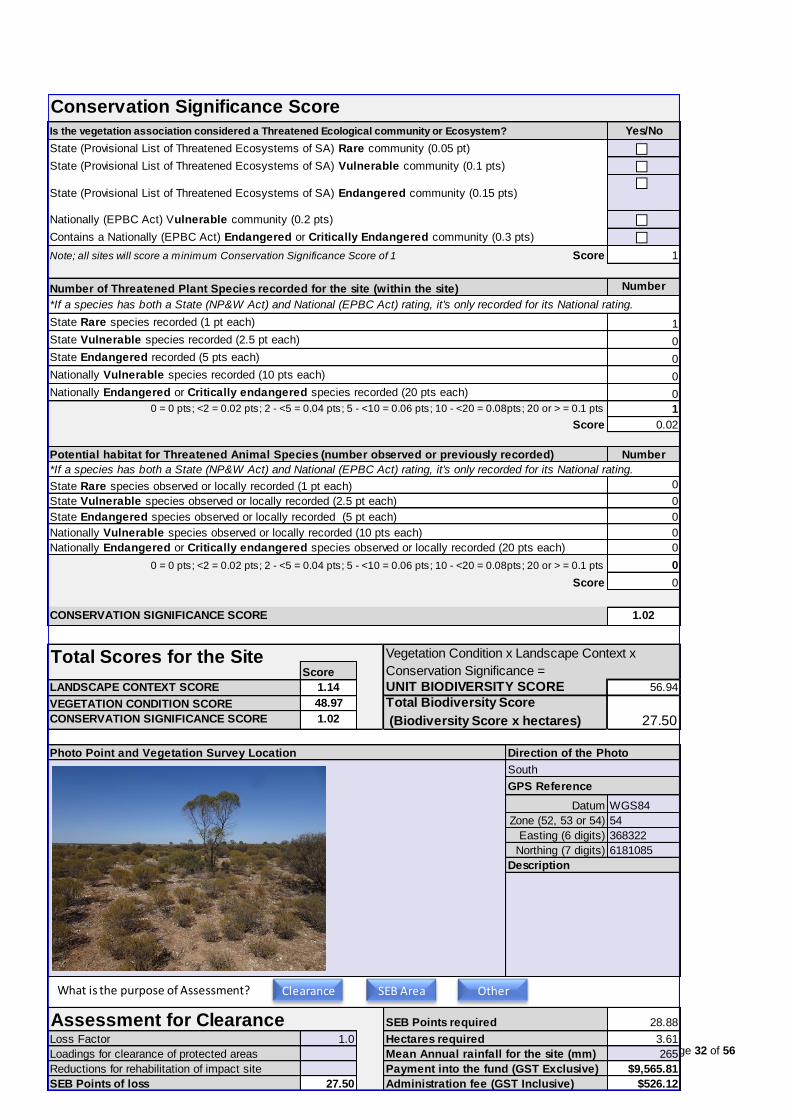
Page 32 of 56
Conservation Significance Score
Is the vegetation association considered a Threatened Ecological community or Ecosystem? Yes/No
State (Provisional List of Threatened Ecosystems of SA) Rare community (0.05 pt) FALSE
State (Provisional List of Threatened Ecosystems of SA) Vulnerable community (0.1 pts) FALSE
State (Provisional List of Threatened Ecosystems of SA) Endangered community (0.15 pts) FALSE
Nationally (EPBC Act) Vulnerable community (0.2 pts) FALSE
Contains a Nationally (EPBC Act) Endangered or Critically Endangered community (0.3 pts) FALSE
Note; all sites will score a minimum Conservation Significance Score of 1 Score 1
Number of Threatened Plant Species recorded for the site (within the site) Number
*If a species has both a State (NP&W Act) and National (EPBC Act) rating, it's only recorded for its National rating.
State Rare species recorded (1 pt each) 1
State Vulnerable species recorded (2.5 pt each) 0
State Endangered recorded (5 pts each) 0
Nationally Vulnerable species recorded (10 pts each) 0
Nationally Endangered or Critically endangered species recorded (20 pts each) 0
1
Score 0.02
Potential habitat for Threatened Animal Species (number observed or previously recorded) Number
*If a species has both a State (NP&W Act) and National (EPBC Act) rating, it's only recorded for its National rating.
State Rare species observed or locally recorded (1 pt each) 0
State Vulnerable species observed or locally recorded (2.5 pt each) 0
State Endangered species observed or locally recorded (5 pt each) 0
Nationally Vulnerable species observed or locally recorded (10 pts each) 0
Nationally Endangered or Critically endangered species observed or locally recorded (20 pts each) 0
0
Score 0
1.02
Vegetation Condition x Landscape Context x
Score Conservation Significance =
LANDSCAPE CONTEXT SCORE 1.14 UNIT BIODIVERSITY SCORE 56.94
VEGETATION CONDITION SCORE 48.97 Total Biodiversity Score
CONSERVATION SIGNIFICANCE SCORE 1.02 (Biodiversity Score x hectares) 27.50
Photo Point and Vegetation Survey Location Direction of the Photo
GPS Reference
Datum WGS84
Zone (52, 53 or 54) 54
Easting (6 digits) 368322
Northing (7 digits) 6181085
Description
Assessment for Clearance SEB Points required 28.88
Loss Factor 1.0 Hectares required 3.61
Loadings for clearance of protected areas Mean Annual rainfall for the site (mm) 265
Reductions for rehabilitation of impact site Payment into the fund (GST Exclusive) $9,565.81
SEB Points of loss 27.50 Administration fee (GST Inclusive) $526.12
0 = 0 pts; <2 = 0.02 pts; 2 - <5 = 0.04 pts; 5 - <10 = 0.06 pts; 10 - <20 = 0.08pts; 20 or > = 0.1 pts
0 = 0 pts; <2 = 0.02 pts; 2 - <5 = 0.04 pts; 5 - <10 = 0.06 pts; 10 - <20 = 0.08pts; 20 or > = 0.1 pts
Total Scores for the Site
South
CONSERVATION SIGNIFICANCE SCORE
What is the purpose of Assessment? Clearance SEB Area Other
Page 33 of 56
Vegetation Community 7
Vegetation Condition Scores
VEGETATION COMMUNITY
BCM COMMUNITY
VEGETATION ASSOCIATION DESCRIPTION
SIZE OF SITE (Ha)
Benchmarked attributes Native Plant Cover
(Scores determined by comparing to a Benchmark community) Life Forms rating
Trees > 15m
Number of Native Species (Minus herbaceous annuals for spring Surveys) 3 Trees 5 - 15 m
Native Plant Species Diversity Score (max 30) from benchmark score Trees < 5m
weighted by a factor of 2 4.0 Mallee > 5m
Mallee < 5m
Number of regenerating native species 0 Shrubs > 2m
Regeneration Score (max 12) from benchmark community weighted by a factor of 1.5 Shrubs 0.5 - 2m 1
0 Shrubs < 0.5 3
Forbs
Weed species Cover C x I Mat Plants
(Top 5 Cover x Invasiveness) (max 6) Grasses > 0.2m
Carrichtera annua 2 4 Grasses < 0.2m 1
Salvia verbenaca var. 1 2 Sedges > 1m
Asphodelus fistulosus 2 4 Sedges < 1m
Marrubium vulgare 1 3 Hummock grasses
0 Vines, scramblers
13 Mistletoe
Weed Score (max 15) from benchmark community 8 Ferns
Grass-tree
Total 5
Native Plant Life Forms (max 20) from benchmark score weighted by a factor of 2 8.0
12
Non-Benchmarked Attributes Is the community naturally treeless? TRUE
(Scores determined from direct field observations) Tree attributes not scored for 3
Native:exotic Understorey biomass score (max 3) 2 treeless community 0
Bare Ground Score (max 5) 2 0
Vegetation Condition Score calculationPositive Vegetation Attributes Score = Native species diversity + Regeneration + Native Plant Life Forms + Native:exotic
- If the community Score is Not Benchmarked (SNB) for regeneration this score is multiplied 1.18
- If the community is naturally treeless this score is multiplied by 1.23 17.22
Negative Vegetation Attributes Score = Weeds + Bare ground 10
15.07
Maximum score 1 0
Vegetation Condition Score0.188344 1
#
#
#
Bare Ground 0.4 1
Native:exotic Understorey Biomass0.666667 0
Regeneration 0 1
Native Plant Life Forms0.4 1
Weed Score 0.533333 0
Native Plant Species Diversity0.133333 1
understorey biomass + Tree health + Fallen timber/debris + Hollow-bearing trees
VEGETATION CONDITION SCORE (Positive veg attributes x ((Negative vegetation attributes + 60) / 80))
Cover x Threat
Rating (max 5)
2
2
2
3
7
MDBSA 2.2 Chenopod Open Shrublands
Atriplex stipitata, Enchylaena tomentosa Low open shrubland
0.3624
Weed Threat
Vegetation Condition Score
Bare Ground
Native:exotic Understorey Biomass
Regeneration
Native Plant Life Forms
Weed Score
Native Plant Species Diversity
Low Medium High

Page 34 of 56
Conservation Significance Score
Is the vegetation association considered a Threatened Ecological community or Ecosystem? Yes/No
State (Provisional List of Threatened Ecosystems of SA) Rare community (0.05 pt) FALSE
State (Provisional List of Threatened Ecosystems of SA) Vulnerable community (0.1 pts) FALSE
State (Provisional List of Threatened Ecosystems of SA) Endangered community (0.15 pts) FALSE
Nationally (EPBC Act) Vulnerable community (0.2 pts) FALSE
Contains a Nationally (EPBC Act) Endangered or Critically Endangered community (0.3 pts) FALSE
Note; all sites will score a minimum Conservation Significance Score of 1 Score 1
Number of Threatened Plant Species recorded for the site (within the site) Number
*If a species has both a State (NP&W Act) and National (EPBC Act) rating, it's only recorded for its National rating.
State Rare species recorded (1 pt each) 0
State Vulnerable species recorded (2.5 pt each) 0
State Endangered recorded (5 pts each) 0
Nationally Vulnerable species recorded (10 pts each) 0
Nationally Endangered or Critically endangered species recorded (20 pts each) 0
0
Score 0
Potential habitat for Threatened Animal Species (number observed or previously recorded) Number
*If a species has both a State (NP&W Act) and National (EPBC Act) rating, it's only recorded for its National rating.
State Rare species observed or locally recorded (1 pt each) 0
State Vulnerable species observed or locally recorded (2.5 pt each) 0
State Endangered species observed or locally recorded (5 pt each) 0
Nationally Vulnerable species observed or locally recorded (10 pts each) 0
Nationally Endangered or Critically endangered species observed or locally recorded (20 pts each) 0
0
Score 0
1
Vegetation Condition x Landscape Context x
Score Conservation Significance =
LANDSCAPE CONTEXT SCORE 1.14 UNIT BIODIVERSITY SCORE 17.18
VEGETATION CONDITION SCORE 15.07 Total Biodiversity Score
CONSERVATION SIGNIFICANCE SCORE 1.00 (Biodiversity Score x hectares) 6.22
Photo Point and Vegetation Survey Location Direction of the Photo
GPS Reference
Datum WGS84
Zone (52, 53 or 54) 54
Easting (6 digits) 368449
Northing (7 digits) 6181109
Description
Assessment for Clearance SEB Points required 6.54
Loss Factor 1.0 Hectares required 0.82
Loadings for clearance of protected areas Mean Annual rainfall for the site (mm) 265
Reductions for rehabilitation of impact site Payment into the fund (GST Exclusive) $2,165.11
SEB Points of loss 6.22 Administration fee (GST Inclusive) $119.08
0 = 0 pts; <2 = 0.02 pts; 2 - <5 = 0.04 pts; 5 - <10 = 0.06 pts; 10 - <20 = 0.08pts; 20 or > = 0.1 pts
0 = 0 pts; <2 = 0.02 pts; 2 - <5 = 0.04 pts; 5 - <10 = 0.06 pts; 10 - <20 = 0.08pts; 20 or > = 0.1 pts
Total Scores for the Site
South-east
CONSERVATION SIGNIFICANCE SCORE
What is the purpose of Assessment? Clearance SEB Area Other

Page 35 of 56
Vegetation Community 8
Vegetation Condition Scores
VEGETATION COMMUNITY
BCM COMMUNITY
VEGETATION ASSOCIATION DESCRIPTION
SIZE OF SITE (Ha)
Benchmarked attributes Native Plant Cover
(Scores determined by comparing to a Benchmark community) Life Forms rating
Trees > 15m
Number of Native Species (Minus herbaceous annuals for spring Surveys) 5 Trees 5 - 15 m
Native Plant Species Diversity Score (max 30) from benchmark score Trees < 5m
weighted by a factor of 2 8.0 Mallee > 5m
Mallee < 5m
Number of regenerating native species 0 Shrubs > 2m 1
Regeneration Score (max 12) from benchmark community weighted by a factor of 1.5 Shrubs 0.5 - 2m 3
0 Shrubs < 0.5 3
Forbs
Weed species Cover C x I Mat Plants
(Top 5 Cover x Invasiveness) (max 6) Grasses > 0.2m
Carrichtera annua 1 2 Grasses < 0.2m 1
Asphodelus fistulosus 2 4 Sedges > 1m
0 Sedges < 1m
Medicago spp. 1 2 Hummock grasses
0 Vines, scramblers
8 Mistletoe 1
Weed Score (max 15) from benchmark community 11 Ferns
Grass-tree
Total 9
Native Plant Life Forms (max 20) from benchmark score weighted by a factor of 2 14.0
22
Non-Benchmarked Attributes Is the community naturally treeless? TRUE
(Scores determined from direct field observations) Tree attributes not scored for 0
Native:exotic Understorey biomass score (max 3) 2 treeless community 0
Bare Ground Score (max 5) 2 0
Vegetation Condition Score calculationPositive Vegetation Attributes Score = Native species diversity + Regeneration + Native Plant Life Forms + Native:exotic
- If the community Score is Not Benchmarked (SNB) for regeneration this score is multiplied 1.18
- If the community is naturally treeless this score is multiplied by 1.23 29.52
Negative Vegetation Attributes Score = Weeds + Bare ground 13
26.94
Maximum score 1 0
Vegetation Condition Score0.336713 1
#
#
#
Bare Ground 0.4 1
Native:exotic Understorey Biomass0.666667 0
Regeneration 0 1
Native Plant Life Forms0.7 0
Weed Score 0.733333 0
Native Plant Species Diversity0.266667 1
8
MDBSA 1.2 Tall Shrubland with Open Arid adapted Understorey on
Limestone Plains
Acacia nysophylla Open shrubland with emergent Myoporum
platycarpum
0.1962
Weed Threat
Rating (max 5)
2
2
2
understorey biomass + Tree health + Fallen timber/debris + Hollow-bearing trees
VEGETATION CONDITION SCORE (Positive veg attributes x ((Negative vegetation attributes + 60) / 80))
Cover x Threat
Vegetation Condition Score
Bare Ground
Native:exotic Understorey Biomass
Regeneration
Native Plant Life Forms
Weed Score
Native Plant Species Diversity
Low Medium High

Page 36 of 56
Conservation Significance Score
Is the vegetation association considered a Threatened Ecological community or Ecosystem? Yes/No
State (Provisional List of Threatened Ecosystems of SA) Rare community (0.05 pt) FALSE
State (Provisional List of Threatened Ecosystems of SA) Vulnerable community (0.1 pts) FALSE
State (Provisional List of Threatened Ecosystems of SA) Endangered community (0.15 pts) FALSE
Nationally (EPBC Act) Vulnerable community (0.2 pts) FALSE
Contains a Nationally (EPBC Act) Endangered or Critically Endangered community (0.3 pts) FALSE
Note; all sites will score a minimum Conservation Significance Score of 1 Score 1
Number of Threatened Plant Species recorded for the site (within the site) Number
*If a species has both a State (NP&W Act) and National (EPBC Act) rating, it's only recorded for its National rating.
State Rare species recorded (1 pt each) 0
State Vulnerable species recorded (2.5 pt each) 0
State Endangered recorded (5 pts each) 0
Nationally Vulnerable species recorded (10 pts each) 0
Nationally Endangered or Critically endangered species recorded (20 pts each) 0
0
Score 0
Potential habitat for Threatened Animal Species (number observed or previously recorded) Number
*If a species has both a State (NP&W Act) and National (EPBC Act) rating, it's only recorded for its National rating.
State Rare species observed or locally recorded (1 pt each) 0
State Vulnerable species observed or locally recorded (2.5 pt each) 0
State Endangered species observed or locally recorded (5 pt each) 0
Nationally Vulnerable species observed or locally recorded (10 pts each) 0
Nationally Endangered or Critically endangered species observed or locally recorded (20 pts each) 0
0
Score 0
1
Vegetation Condition x Landscape Context x
Score Conservation Significance =
LANDSCAPE CONTEXT SCORE 1.14 UNIT BIODIVERSITY SCORE 30.71
VEGETATION CONDITION SCORE 26.94 Total Biodiversity Score
CONSERVATION SIGNIFICANCE SCORE 1.00 (Biodiversity Score x hectares) 6.02
Photo Point and Vegetation Survey Location Direction of the Photo
GPS Reference
Datum WGS84
Zone (52, 53 or 54) 54
Easting (6 digits) 368513
Northing (7 digits) 6181177
Description
Assessment for Clearance SEB Points required 6.33
Loss Factor 1.0 Hectares required 0.79
Loadings for clearance of protected areas Mean Annual rainfall for the site (mm) 265
Reductions for rehabilitation of impact site Payment into the fund (GST Exclusive) $2,095.55
SEB Points of loss 6.02 Administration fee (GST Inclusive) $115.26
CONSERVATION SIGNIFICANCE SCORE
0 = 0 pts; <2 = 0.02 pts; 2 - <5 = 0.04 pts; 5 - <10 = 0.06 pts; 10 - <20 = 0.08pts; 20 or > = 0.1 pts
0 = 0 pts; <2 = 0.02 pts; 2 - <5 = 0.04 pts; 5 - <10 = 0.06 pts; 10 - <20 = 0.08pts; 20 or > = 0.1 pts
Total Scores for the Site
South
What is the purpose of Assessment? Clearance SEB Area Other

Page 37 of 56
Appendix 2: Representative photographs
Community/Site 1: False Sandalwood (Myoporum platycarpum) Low open woodland. Facing South at
368664/6181630.

Page 38 of 56
Community/Site 2: Senna spp. +/- Spine Bush (Acacia nyssophylla) Shrubland with widely scattered emergent False
Sandalwood (Myoporum platycarpum). Facing South at 368595/6181675.

Page 39 of 56
Community/Site 3: Bitter Saltbush (Atriplex stipitata) Low open shrubland with emergent Senna spp. and Spine
Bush (Acacia nyssophylla). Facing South at 368861/6182008.

Page 40 of 56
Planted
Aleppo Pines (*Pinus halepensis) which occur on the south-western boundary of Area 1.

Page 41 of 56
Community/Site 4: Atriplex stipitata Low shrubland with emergent Acacia nysophylla, Dodonaea viscosa ssp.
Facing South at 368843/6181585.

Page 42 of 56
Community/Site 5: Dodonaea viscosa ssp. +/- Acacia nysophylla Open shrubland with emergent Myoporum
platycarpum, Acacia oswaldii, Facing South at 368720/6181477

Page 43 of 56
Community/Site 6: Senna artemisioides ssp. +/- Acacia nysophylla Shrubland with emergent Myoporum
platycarpum. Facing South-east at 368322/6181085.

Page 44 of 56
Community/Site 7: Atriplex stipitata, Enchylaena tomentosa Low open shrubland. Facing South-east at
368449/6181109.

Page 45 of 56
Community/Site 8: Acacia nysophylla Open shrubland with emergent Myoporum platycarpum. Facing South at
368513/6181177.

Page 46 of 56
Tree 1: Eucalyptus camaldulensis ssp. camaldulensis.

Page 47 of 56
Tree 2: Eucalyptus camaldulensis ssp. camaldulensis (on LHS of Tree 1).
Tree 3: Eucalyptus camaldulensis ssp. camaldulensis (on RHS of Tree 1).

Page 48 of 56
Appendix 3: Threatened ecological communities, flora and fauna species potentially occurring in the project area.
(Note that fish species have been excluded.)
Species Common Name EPBC Rating NPWS Rating Source Likelihood of occurrence
Ecological Community
Buloke Woodlands of the Riverina and Murray-Darling
Depression Bioregions
Endangered Protected Matters
Search Tool
This community was not recorded during field assessment
and habitat is not suitable
Plants
Adiantum capillus-veneris Dainty Maiden-hair Vulnerable BDBSA Previously recorded near to the river – the project area does
not provide suitable habitat.
Austrostipa pilata Prickly Spear-grass Vulnerable Naturemaps Grows in mallee11 – unlikely as habitat is not suitable.
Austrostipa tenuifolia Rare BDBSA Grows in sandy soils in grassland or grassy woodland
associated with Callitris or Allocasuarina12. The project area
does not provide suitable habitat.
Brachyscome graminea Grass Daisy Rare BDBSA Grows in moist areas from swamps to saline marshes and
along watercourses13. The project area does not provide
suitable habitat.
Brachyscome paludicola Swamp Daisy Rare BDBSA Found along the Murray River and in the South-east of South
Australia, growing on inundated clay soils and common in
seasonally wet, red gum dominated flats14. The project area
does not provide suitable habitat.
Callistemon brachyandrus Prickly Bottlebrush Rare BDBSA Found along the Murray River in South Australia mainly
between Swan Reach and Wailkerie growing in the sandy
soils of alluvial flats15. The project area does not provide
suitable habitat.
Calotis scapigera Tufted Burr-daisy Rare BDBSA Found mainly along the River Murray in South Australia with
some scattered records further north, growing chiefly in
saltbush and river red gum communities, on damp clay soils
11 https://spapps.environment.sa.gov.au/SeedsOfSA/ 12 https://spapps.environment.sa.gov.au/SeedsOfSA/speciesinformation.html?rid=620 13 https://spapps.environment.sa.gov.au/SeedsOfSA/speciesinformation.html?rid=751 14 https://spapps.environment.sa.gov.au/SeedsOfSA/speciesinformation.html?rid=734 15 https://spapps.environment.sa.gov.au/SeedsOfSA/speciesinformation.html?rid=898

Page 49 of 56
Species Common Name EPBC Rating NPWS Rating Source Likelihood of occurrence
in flood-prone areas16. The project area does not provide
suitable habitat.
Ceratophyllum demersum Hornwort Rare BDBSA A submerged, free-flowing aquatic plant.
Cristella dentata Rare BDBSA A small fern which forms tussocks along stream banks, on
rainforest margins or in open forest17. The project area does
not provide suitable habitat.
Dodonaea subglandulifera Peep Hill Hop-bush Endangered Endangered Protected Matters
Search Tool
Grows on low hills on loamy soils associated with rocky
outcrops in open woodland, open shrubland and mallee8.
Site is considered too degraded to support this species.
Duma horrida ssp. horrida Spiny Lignum Rare Naturemaps
BDBSA
Grows on floodplains and beside dry inland lakes8, therefore
unlikely as habitat is not suitable.
Elatine gratioloides Waterwort Rare Naturemaps
BDBSA
Grows in or on the margins of stationary or slow-flowing
water8, therefore unlikely as habitat is not suitable.
Eragrostis lacunaria Purple Love Grass Rare BDBSA Widespread on clay soils of inland18. Not recorded during
field assessment.
Lythrum salicaria Purple Loosestrife Rare Naturemaps
BDBSA
Grows in moist places or near water, often in swamps or the
edge of streams8, therefore unlikely as habitat is not suitable.
Maireana pentagona Slender Fissure-
plant
Rare BDBSA Widespread, especially on heavier red and brown soils. Often
found growing in large numbers on cracking grey clay River
Murray floodplains19. The project area does not provide
suitable habitat.
Maireana rohrlachii Rohrlach’s
Bluebush
Rare BDBSA Yes – several plants recorded during this field assessment.
Microlepidium pilosulum Hairy Shepherd’s-
purse
Rare BDBSA Grows on sand and loam in coastal dunes and salt lake
margins20. The project area does not provide suitable
habitat.
Myriophyllum papillosum Robust Milfoil Rare BDBSA An aquatic species.
16 https://spapps.environment.sa.gov.au/SeedsOfSA/speciesinformation.html?rid=939 17 http://plantnet.rbgsyd.nsw.gov.au/cgi-bin/NSWfl.pl?page=nswfl&lvl=sp&name=Christella~dentata 18 http://plantnet.rbgsyd.nsw.gov.au/cgi-bin/NSWfl.pl?page=nswfl&lvl=sp&name=Eragrostis~lacunaria 19https://spapps.environment.sa.gov.au/SeedsOfSA/speciesinformation.html?rid=2806 20 https://spapps.environment.sa.gov.au/SeedsOfSA/speciesinformation.html?rid=2930
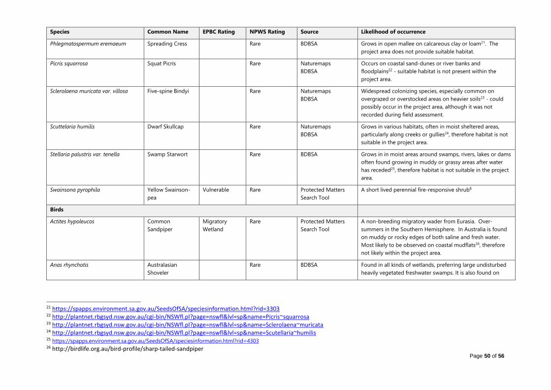
Page 50 of 56
Species Common Name EPBC Rating NPWS Rating Source Likelihood of occurrence
Phlegmatospermum eremaeum Spreading Cress Rare BDBSA Grows in open mallee on calcareous clay or loam21. The
project area does not provide suitable habitat.
Picris squarrosa Squat Picris Rare Naturemaps
BDBSA
Occurs on coastal sand-dunes or river banks and
floodplains22 - suitable habitat is not present within the
project area.
Sclerolaena muricata var. villosa Five-spine Bindyi Rare Naturemaps
BDBSA
Widespread colonizing species, especially common on
overgrazed or overstocked areas on heavier soils23 - could
possibly occur in the project area, although it was not
recorded during field assessment.
Scuttelaria humilis Dwarf Skullcap Rare Naturemaps
BDBSA
Grows in various habitats, often in moist sheltered areas,
particularly along creeks or gullies24, therefore habitat is not
suitable in the project area.
Stellaria palustris var. tenella Swamp Starwort Rare BDBSA Grows in in moist areas around swamps, rivers, lakes or dams
often found growing in muddy or grassy areas after water
has receded25, therefore habitat is not suitable in the project
area.
Swainsona pyrophila Yellow Swainson-
pea
Vulnerable Rare Protected Matters
Search Tool
A short lived perennial fire-responsive shrub8
Birds
Actites hypoleucos Common
Sandpiper
Migratory
Wetland
Rare Protected Matters
Search Tool
A non-breeding migratory wader from Eurasia. Over-
summers in the Southern Hemisphere. In Australia is found
on muddy or rocky edges of both saline and fresh water.
Most likely to be observed on coastal mudflats26, therefore
not likely within the project area.
Anas rhynchotis Australasian
Shoveler
Rare BDBSA Found in all kinds of wetlands, preferring large undisturbed
heavily vegetated freshwater swamps. It is also found on
21 https://spapps.environment.sa.gov.au/SeedsOfSA/speciesinformation.html?rid=3303 22 http://plantnet.rbgsyd.nsw.gov.au/cgi-bin/NSWfl.pl?page=nswfl&lvl=sp&name=Picris~squarrosa 23 http://plantnet.rbgsyd.nsw.gov.au/cgi-bin/NSWfl.pl?page=nswfl&lvl=sp&name=Sclerolaena~muricata 24 http://plantnet.rbgsyd.nsw.gov.au/cgi-bin/NSWfl.pl?page=nswfl&lvl=sp&name=Scutellaria~humilis 25 https://spapps.environment.sa.gov.au/SeedsOfSA/speciesinformation.html?rid=4303 26 http://birdlife.org.au/bird-profile/sharp-tailed-sandpiper

Page 51 of 56
Species Common Name EPBC Rating NPWS Rating Source Likelihood of occurrence
open waters and occasionally along the coast27. More likely
to be found on the River Murray.
Anhinga novaehollandiae Australasian Darter Rare BDBSA Found in wetlands and sheltered coastal waters, mainly in the
Tropics and Subtropics. It prefers smooth, open waters, for
feeding, with tree trunks, branches, stumps or posts fringing
the water, for resting and drying its wings. Most often seen
inland, around permanent and temporary water bodies at
least half a metre deep28. More likely to be found on the
River Murray.
Apus pacificus Fork-tailed Swift Migratory
Marine
- Protected Matters
Search Tool
Possible flying overhead as this species is almost exclusively
aerial – in South Australia is widespread from the Victorian
border west to the Spencer Gulf29.
Ardea alba Great Egret Migratory
Marine
- Protected Matters
Search Tool
A possible visitor. Site is unlikely to form significant habitat
for this species.
Ardea ibis Cattle Egret Migratory
Marine
- Protected Matters
Search Tool
A possible visitor - found in grasslands, woodlands and
wetlands. It also uses pastures and croplands, especially
where drainage is poor. Will also forage at garbage dumps,
and is often seen with cattle and other stock30. However, the
site is unlikely to form significant habitat for this species.
Biziura lobata Musk Duck Rare BDBSA Unlikely – an aquatic species.
Burhinus grallerius Bush Stonecurlew Rare BDBSA
Calidris acuminata Sharp-tailed
Sandpiper
Migratory
Wetland
- Protected Matters
Search Tool
A summer migrant which prefers the grassy edges of shallow
inland freshwater wetlands. It is also found around sewage
farms, flooded fields, mudflats, mangroves, rocky shores and
beaches. Breeds in Siberia31.
Calidris ferruginea Curlew Sandpiper Critically
Endangered
- Protected Matters
Search Tool
Found on intertidal mudflats of estuaries, lagoons,
mangroves, as well as beaches, rocky shores and around
lakes, dams and floodwaters. Breeds in the Northern
27 http://www.birdlife.org.au/bird-profile/australasian-shoveler 28 https://www.birdlife.org.au/bird-profile/australasian-darter 29 http://www.environment.gov.au/cgi-bin/sprat/public/publicspecies.pl?taxon_id=678 30 http://www.birdsinbackyards.net/species/Ardea-ibis 31 http://birdlife.org.au/bird-profile/sharp-tailed-sandpiper

Page 52 of 56
Species Common Name EPBC Rating NPWS Rating Source Likelihood of occurrence
Hemisphere32.. Possibly could be an occasional visitor,
however the project area does not provide critical habitat.
Calidris melanotos Pectoral Sandpiper Migratory
Wetland
Rare Protected Matters
Search Tool
In South Australia this species is found mostly in the south-
east, from north to the Murray River and west to Yorke
Peninsula. Prefers shallow fresh to saline wetlands. The
species is found at coastal lagoons, estuaries, bays, swamps,
lakes, inundated grasslands, saltmarshes, river pools, creeks,
floodplains and artificial wetlands33. Site is unlikely to form
significant habitat for this species.
Chrysococcyx osculans Black-eared
Cuckoo
Migratory
Marine
- Protected Matters
Search Tool
Not likely – Habitat includes dry open forests, scrublands,
mallee, mulga, lignum, saltbush and riverside thickets.34.
Cladorhynchus leucocephalus Banded Stilt Vulnerable BDBSA Found mainly in saline and hypersaline (very salty) waters of
the inland and coast, typically large, open and shallow35.
More likely to be found on the River Murray.
Corcorax melanorhamphos White-winged
Chough
Rare BDBSA Found in open forests and woodlands. They tend to prefer
the wetter areas, with lots of leaf-litter, for feeding, and
available mud for nest building36. The project area does not
provide suitable habitat for this species.
Egretta garzetta Little Egret Rare BDBSA Unlikely – an aquatic species.
Falco peregrinus Peregrine Falcon Rare BDBSA This species requires abundant prey and secure nest sites,
and prefers coastal and inland cliffs or open woodlands near
water37. The project area does not provide critical habitat for
this species.
Gallinago hardwickii Latham’s Snipe Migratory
Wetland
Rare Protected Matters
Search Tool
A migratory wetland bird which breeds in Japan. In Australia,
found in freshwater wetlands on or near the coast, generally
amongst dense cover30. Site is unlikely to form significant
habitat for this species.
32 Tim Croft, Ornithologist 33 http://www.environment.gov.au/cgi-bin/sprat/public/publicspecies.pl?taxon_id=858 34 https://en.wikipedia.org/wiki/Black-eared_cuckoo 35 http://www.birdlife.org.au/bird-profile/banded-stilt 36 http://www.birdlife.org.au/bird-profile/white-winged-chough 37 http://www.birdlife.org.au/bird-profile/peregrine-falcon

Page 53 of 56
Species Common Name EPBC Rating NPWS Rating Source Likelihood of occurrence
Haliaetus leucogaster White-bellied Sea-
eagle
Migratory
Marine
Endangered Protected Matters
Search Tool
BDBSA
Possibly recorded perched high in a tree, or soaring over
waterways and adjacent land38, however the site is unlikely to
form significant habitat for this species.
Leipoa ocellata Malleefowl Vulnerable Vulnerable Protected Matters
Search Tool
BDBSA
Not likely – habitat is not suitable.
Melanodryas cucullata Hooded Robin Rare BDBSA Found in lightly timbered woodland, mainly dominated by
acacia and/or eucalypts39. The project area is quite degraded
and probably does not provide critical habitat for this
species.
Merops ornatus Rainbow Bee-eater Marine
Migratory
- Protected Matters
Search Tool
A possible visitor. Most often found in open forests,
woodlands and shrublands, and cleared areas, usually near
water. It will be found on farmland with remnant vegetation
and in orchards and vineyards. It will use disturbed sites such
as quarries, cuttings and mines to build its nesting tunnels40 .
However, the site is unlikely to form significant habitat for
this species.
Motacilla cinerea Grey Wagtail Migratory
Terrestrial
- Protected Matters
Search Tool
Always associated with running water when breeding – may
be a visitor to the site however its unlikely to form significant
habitat for this species30.
Motacilla flava Yellow Wagtail Migratory
Terrestrial
- Protected Matters
Search Tool
Possibly an occasional visitor. Breeds in Europe and Asia.
Site is unlikely to form significant habitat for this species30.
Myiagra cyanoleuca Satin Flycatcher Migratory
Terrestrial
Endangered Protected Matters
Search Tool
Not likely - found in tall forests, preferring wetter habitats
such as heavily forested gullies, but not rainforests41.
Myiagra inquieta Restless Flycatcher Rare BDBSA Found in open forests and woodlands and is frequently seen
in farmland42, however the project area is not likely to
provide critical habitat for this species.
Neophema elegans Elegant Parrot Rare BDBSA Can be found in a wide variety of habitats, including
grasslands, shrublands, mallee, woodlands and thickets,
38 http://www.birdlife.org.au/bird-profile/white-bellied-sea-eagle 39 http://www.birdsinbackyards.net/species/Melanodryas-cucullata 40 http://birdlife.org.au/bird-profile/rainbow-bee-eater 41 http://www.birdlife.org.au/bird-profile/satin-flycatcher 42 http://birdlife.org.au/bird-profile/restless-flycatcher

Page 54 of 56
Species Common Name EPBC Rating NPWS Rating Source Likelihood of occurrence
bluebush plains, heathlands, saltmarsh and farmland43.
Could possibly utilize the project area, however it is not likely
to provide critical habitat.
Numenius madagascariensis Eastern Curlew Critically
Endangered
Vulnerable Protected Matters
Search Tool
Found on intertidal mudflats and sandflats, often with beds
of seagrass, on sheltered coasts, especially estuaries,
mangrove swamps, bays, harbours and lagoons44. The
project area is unlikely to form significant habitat for this
species.
Oxyura australis Blue-billed Duck Rare BDBSA Unlikely – an aquatic species.
Pandion haliaetus Osprey Migratory
Wetland
Endangered Protected Matters
Search Tool
A largely sedentary bird of prey found around the coast and
off-shore islands and, at times, terrestrial wetlands and along
inland rivers. It builds nests on cliffs or in dead trees30.
Pachycephala pectoralis Golden Whistler Rare BDBSA Can be found in almost any wooded habitat, from rainforest
to mallee, but prefers the denser areas45. Occasionally it visits
parks and orchards. Could possibly ustilise the Myoporum
platycarpum Low Woodland (Community 1) and the
scattered Red Gums closer to the River.
Pedionomus torquatus Plains-wanderer Critically
Endangered
Endangered Protected Matters
Search Tool
A sedentary bird, primarily observed in open sparse
grasslands, and unlikely in dense, improved grasslands or in
treed areas. Its nest is a hollow on the ground. Due to
agricultural development now found in the north east
pastoral area and possibly the northern Flinders Ranges30.
Not likely to utilise the project area.
Pezoporus anthopeplus Regent Parrot Endangered Endangered Protected Matters
Search Tool
Found in River Red Gum, Eucalyptus camaldulensis,
floodplain, woodland and mallee46, therefore the project area
would not provide suitable habitat for this species.
Plectorhyncha lanceolata Striped Honeyeater Rare BDBSA Found in forests and woodlands, often along rivers47 – more
likely to have been recorded on the River Murray.
43 http://birdlife.org.au/bird-profile/elegant-parrot 44 https://www.birdlife.org.au – accessed February 2019 45 http://www.birdlife.org.au/bird-profile/golden-whistler 46 http://www.birdlife.org.au/bird-profile/regent-parrot 47 http://www.birdsinbackyards.net/species/Plectorhyncha-lanceolata

Page 55 of 56
Species Common Name EPBC Rating NPWS Rating Source Likelihood of occurrence
Plegadis falcinellus Glossy Ibits Rare BDBSA Requires shallow water and mudflats, so is found in well-
vegetated wetlands, floodplains, mangroves and ricefields48.
Therefore not likely to be found in the project area.
Polytelis anthopeplus Night Parrot Vulnerable Vulnerable Protected Matters
Search Tool
BDBSA
Usually inhabits arid or semi-arid grasslands that are
dominated by spinifex, though they have also been recorded
in shrublands dominated by samphire, bluebush and
saltbush49. However, the project area is considered to be
quite degraded, therefore this species is unlikely to be
present.
Rostratula australis Australian Painted-
snipe
Endangered Vulnerable Protected Matters
Search Tool
A widespread, mobile, sparsely distributed wetland bird,
mostly associated with the Murray Darling Basin. It is found
in various shallow, brackish or freshwater, especially
temporary wetlands, with muddy margins and small, low-
lying islands. In SA it is an erratic spring-autumn breeding
visitor along the River Murray, South East and at times the
Mount Lofty Ranges30. The project does not provide
suitable habitat for this species.
Rostratula benghalensis Painted Snipe Endangered Vulnerable Protected Matters
Search Tool
Not likely as habitat is not suitable - generally inhabits
shallow terrestrial freshwater (occasionally brackish)
wetlands, including temporary and permanent lakes, swamps
and claypans. They also use inundated or waterlogged
grassland or saltmarsh, dams, rice crops, sewage farms and
bore drains50.
Stictonetta naevosa Freckled Duck Vulnerable BDBSA Unlikely – an aquatic species.
Tringa nebularia Common
Greenshank
Migratory
Wetland
- Protected Matters
Search Tool
Does not breed in Australia. Seen singly or in small to large
flocks (sometimes hundreds) in a variety of coastal and
inland wetlands51.
Mammals
Bettongia lesueur Burrowing Bettong Extinct Endangered BDBSA Considered to be regionally extinct.
48 http://www.birdlife.org.au/bird-profile/glossy-ibis 49 http://birdlife.org.au/bird-profile/night-parrot 50 http://www.environment.gov.au/cgi-bin/sprat/public/publicspecies.pl?taxon_id=77037 51 http://www.environment.gov.au/cgi-bin/sprat/public/publicspecies.pl?taxon_id=832

Page 56 of 56
Species Common Name EPBC Rating NPWS Rating Source Likelihood of occurrence
Bettongia penicillata ogilbyi Woylie Endangered Rare Protected Matters
Search Tool
BDBSA
Not likely – protected in the nearby Yookamurra Private
Nature Reserve. (Regionally extinct)
Macrotis lagotis Greater Bilby Vulnerable Vulnerable Protected Matters
Search Tool
BDBSA
Not likely – protected in the nearby Yookamurra Private
Nature Reserve.
Myrmecobius fasciatus Numbat Endangered Endangered BDBSA This species is considered to be regionally extinct52.
Nyctophilus corbeni Corben’s Long-
eared Bat
Vulnerable Protected Matters
Search Tool
Found in an array of inland woodland vegetation types,
including box, ironbark and cypress pine woodlands; Buloke,
Belah, River Red Gum and Black Box woodlands as well as a
variety of mallee vegetation53. More likely to be found on
the River Murray floodplain.
Trichosurus vulpecula Common Brushtail
Possum
Rare BDBSA Not likely to be found in the project area as the trees do not
possess hollows.
Frogs
Littoria raniformis Southern Bell Frog Vulnerable Vulnerable Protected Matters
Search Tool
Naturemaps
BDBSA
This species is found throughout the River Murray and South
East in large permanent waterbodies with abundant growth
of vegetation near the bank54. Not likely as habitat is not
suitable.
Reptiles
Chelodina expansa Broadshelled Turtle Vulnerable Naturemaps
BDBSA
A riverine species, therefore would not use the project area.
Empydura macquarii Macquarie River
Turtle
Vulnerable Naturemaps
BDBSA
A riverine species, therefore would not use the project area.
Morelia spilota Carpet Python Rare BDBSA Known from cliffs and Red Gums along the river, however
unlikely to utilise the project area.
Varanus varius Lace Monitor Rare BDBSA Known from cliffs and Red Gums along the river, however
unlikely to utilise the project area.
52 Gillam, S. and Urban, R. (2010) Regional Species Conservation Assessment Project, Phase 1 Report: Regional Species Status Assessments, Murraylands Region. Department of Environment and Natural Resources, South Australia. 53 https://en.wikipedia.org/wiki/Nyctophilus_corbeni 54 https://www.frogwatchsa.com.au/species/view/10