sustainable drainage systems (suds) handbook · sustainable drainage systems: nonstatutory...
TRANSCRIPT

Planning CommitteeSite Visit Protocol
Sustainable Drainage Systems(SuDS) Handbook
www.staffordshire.gov.uk
February 2017
Page 2 Sustainable Drainage Systems (SuDS) Handbook Arcadis Consulting (UK) Limited -2212959
Page Intentionally Blank

CONTENTS
1 Overview ............................................................................................... 2 1.1 What are SuDS? ................................................................................... 2 1.2 What does the SuDS Handbook cover? ............................................... 3 1.3 Why has the SuDS Handbook been produced? ................................... 3 1.4 Who should use the SuDS Handbook? ................................................ 4 1.5 Local Governance ................................................................................ 5 1.6 SuDS Delivery Partners and their Roles ............................................... 5 1.7 National Standards and Local Standards ............................................. 6
2 The Planning Process .......................................................................... 7 2.1 Planning Process and Timescales ........................................................ 7 2.2 Surface Water Drainage Proforma ..................................................... 10 2.3 Technical Review of SuDS Submission .............................................. 10 2.4 Arrangements for Maintenance of SuDS ............................................ 10 2.5 SuDS Adoption ................................................................................... 11 2.6 Other Consents which may be Required Outside of the Planning
Process............................................................................................... 12 3 SuDS Design Guidance...................................................................... 15
3.1 The Importance of Pre-Application Discussions and the Viability of SuDS .................................................................................................. 15
3.2 Recommended Approach to the Inclusion of SuDS within a Development ...................................................................................... 16
3.3 Establishment of Environmental Assets and Constraints.................... 17 3.4 Selection of SuDS Features ............................................................... 20 3.5 Design Criteria .................................................................................... 23 3.6 Flood Risk ........................................................................................... 30 3.7 Sewerage Assets ................................................................................ 33 3.8 Designing for Maintenance and Safety ............................................... 33 3.9 Historic Environment .......................................................................... 34 3.10 Delivering Multiple Benefits ................................................................ 35 3.11 Water Quality and the Water Framework Directive ............................. 37 3.12 Designation of SuDS Constructed on Third Party Land ...................... 38 3.13 Riparian Responsibilities .................................................................... 38 3.14 Useful Resources & References ......................................................... 39
Page i Sustainable Drainage Systems (SuDS) Handbook Arcadis Consulting (UK) Limited -2212959

Appendices Appendix A Surface Water Drainage Proforma Appendix B Local Standards Appendix C Hydraulic Model Parameters Appendix D Available SuDS Features Appendix E
LLFA Specific Appendix
Page i Sustainable Drainage Systems (SuDS) Handbook Arcadis Consulting (UK) Limited -2212959

1 Overview This Sustainable Drainage Systems (SuDS) Handbook sets out the role of SuDS in achieving sustainable development across nine Lead Local Flood Authorities (LLFA) in the West Midlands:
Black Country Authorities:
Dudley Metropolitan Borough Council
Sandwell Metropolitan Borough Council
Walsall Metropolitan Borough Council
Wolverhampton City Council
Herefordshire Council
Shropshire Council
Staffordshire County Council
Stoke-on-Trent City Council
Telford and Wrekin Council
The SuDS Handbook shows how early consideration of surface water drainage issues can ensure that an effective SuDS scheme can easily be delivered on any site. The nine LLFAs listed above are the strategic leaders for local flood risk management in their respective Local Authority Areas and have agreed to work collaboratively to deliver this SuDS Handbook. Henceforth, the term LLFA is used to describe the role of all nine Authorities.
This Handbook is not intended to reproduce or replace the CIRIA SuDS Manual which should be consulted for detailed guidance on the design and construction of SuDS.
1.1 What are SuDS? SuDS are an approach to managing surface water (rainfall runoff) which mimic the natural processes of attenuation, infiltration and evapotranspiration. SuDS comprise a sequence of management practices, control structures and strategies which are designed to drain surface water efficiently and sustainably, whilst also minimising pollution and managing the impact on the water quality of local water bodies. SuDS provide a wide range of opportunities to enhance the biodiversity, landscape and amenity value of a site ensuring that multiple benefits of the surface water drainage strategy are fully realised.
Page 2 Sustainable Drainage Systems (SuDS) Handbook Arcadis Consulting (UK) Limited -2212959

1.2 What does the SuDS Handbook cover?
Figure 1-1 SuDS Handbook Chapters
The first chapter provides some background context, contains information on the roles and responsibilities of the various bodies involved in planning and approving SuDS schemes and concludes with some information about the non-statutory Technical Standards for SuDS (Defra, 2015).
The second chapter of the SuDS Handbook explains the SuDS approval process and how this links with the planning process.
The third chapter provides guidance on SuDS design, incorporating both the non-statutory National SuDS Standards and the Local SuDS Standards. Chapter three also includes examples of best practice SuDS implementation.
In addition, six versions of Appendix E have been produced each of which contain information specific to the individual LLFA’s listed above.
1.3 Why has the SuDS Handbook been produced? Section 10 of the National Planning Policy Framework (the NPPF) sets out the expectation that Local Planning Authorities (LPAs), as part of their function of determining planning applications, should avoid flood risk to people and property and should manage any residual risk. The expectation is clear that SuDS must be provided in new developments and that approval for all SuDS for major developments must be granted through the planning system.
SuDS Handbook
Chapter 1 Overview
Chapter 2 The Planning Process
Chapter 3 SuDS Design Guidance
Appendices
Appendix A Surface Water Drainage
Proforma
Appendix B Local Standards
Appendix C Hydraulic Model Parameters
Appendix D Available SuDS Features
Appendix E LLFA Specific
Page 3 Sustainable Drainage Systems (SuDS) Handbook Arcadis Consulting (UK) Limited -2212959

Major development is defined in The Town and Country Planning (Development Management Procedure) 2015 as development involving any one or more of the following:
(a) the winning and working of minerals or the use of land for mineral-working deposits;
(b) waste development;
(c) the provision of dwellinghouses where -
(i) the number of dwellinghouses to be provided is 10 or more; or
(ii) the development is to be carried out on a site having an area of 0.5 hectares or more and it is not known whether the development falls within sub-paragraph (c) (i);
(d) the provision of a building or buildings where the floor space to be created by the development is 1,000 square metres or more; or
(e) development carried out on a site having an area of 1 hectare or more.
1.4 Who should use the SuDS Handbook? The SuDS Handbook has been produced for use by anyone undertaking or granting and reviewing permissions to undertake construction work which has surface water drainage implications; examples are shown in Figure 1-2.
Figure 1-2 Who Should Use the SuDS Handbook (1e.g. Internal Drainage Boards (IDBs), Reservoir Undertakers, Navigation Authorities)
The SuDS Handbook will be used by LPAs across the nine LLFAs for reference when assessing planning applications. Details of how the guidance in this Handbook will be used within the nine LLFAs is included within their LLFA specific appendix (Appendix E)
Public Sector
Developers
Private Sector
Developers
Local Authority Property Services
Risk Management Authorities1
Water and Sewerage
Companies
Environment Agency
Local Planning
Authorites
Parish / Town
councils
Page 4 Sustainable Drainage Systems (SuDS) Handbook Arcadis Consulting (UK) Limited -2212959

The Handbook may also be of interest to Parish Councils and Town Councils in raising awareness of the drainage issues associated with developments in their localities.
The SuDS Handbook is focussed predominantly on major developments referred to in Section 1.3 above. For any other developments, surface water drainage arrangements should still comply with local planning policies and guidance (see LLFA specific appendix) and national planning policies and guidance including:
The NPPF
House of Commons Written Statement on SuDS
Planning Practice Guidance on flood risk
Gov.uk advice on planning and flood risk
1.5 Local Governance Local governance within each LLFA is discussed within the relevant LLFA appendix.
1.6 SuDS Delivery Partners and their Roles The Environment Agency is a statutory consultee in relation to flood risk for all major planning applications that are in an area at risk of Main River flooding as shown on the Flood Map for Planning or within 20m of the top of a Main River bank. The Environment Agency will therefore need to comment on applications for major developments which fall within these criteria.
Consent to directly discharge to a Main River1 may be also be required from the Environment Agency and from the LLFA for discharges to ordinary watercourses2.
Highways England and the Highways Authority within each LLFA are responsible for adopting and maintaining adopted highway drainage systems serving public highways. Highways England are responsible for motorways and trunk roads only. They must be consulted on any SuDS within public highways and those that might impact local rights of way. Contact details for the Highways Authority within each LLFA can be found in the LLFA specific appendix.
As non-statutory consultees, Water and Sewerage Companies can act in an advisory role, commenting on any SuDS schemes that have potential to impact upon existing or proposed sewerage infrastructure. Connection to the public sewerage network should only be considered after all options for discharging the surface water have been properly assessed with the LLFA. Where discharge to a public sewer is required the Water and Sewerage Companies must be contacted directly in relation to any proposed connections to, or impacts on, the public sewer network. Contact details for the relevant Water and Sewerage Companies can be found in the LLFA specific appendix.
Internal Drainage Boards should be consulted on any development that is likely to directly or indirectly discharge water into an ordinary watercourse within the Board’s district. Consent or agreement to discharge may also be required from the relevant Board. Contact details can be found in the relevant appendix and more general information can be found via the Association of Drainage Authorities.
1 Responsibility for managing flood risk lies with the Environment Agency; Main Rivers are shown on the Main River Map. 2 An ordinary watercourse is any river, stream, ditch, drain, cut, dyke, sluice, sewer (other than a public sewer) and passage through which water flows and which does not form part of a main river network. Consent may be required for both permanent and temporary works.
Page 5 Sustainable Drainage Systems (SuDS) Handbook Arcadis Consulting (UK) Limited -2212959

1.7 National Standards and Local Standards Defra published ‘Sustainable Drainage Systems: Non-statutory Technical Standards for Sustainable Drainage Systems in March 2015 to ensure a consistent approach to the design and enforcement of SuDS across the country. A Best Practice Guidance Document has been published by the Local Authority SuDS Officer Organisation (LASOO) which provides further interpretation and guidance in relation to the National Standards.
However, LLFAs and Local Planning Authorities can set local standards to complement national requirements and to prioritise local needs. The National Standards and the Local SuDS Standards are explained in Chapter 3.
Page 6 Sustainable Drainage Systems (SuDS) Handbook Arcadis Consulting (UK) Limited -2212959

2 The Planning Process This chapter of the SuDS Handbook provides information about the process whereby the proposed SuDS scheme for a major development will be considered through the planning system. This process is illustrated in Figure 2-1.
Figure 2-1 Process for Considering SuDS Scheme Applications for Major Development
2.1 Planning Process and Timescales
2.1.1 Pre-application Discussion The LLFA strongly recommend that they are involved in early pre-application discussions alongside other key stakeholders when the development of a site is initially being considered. Pre-application discussions will help to ensure that SuDS are considered at the appropriate time, ahead of or as part of the production of preliminary development layouts, and that they are fully integrated into the final development layout. Appendix B of the CIRIA SuDS Manual sets out suggested material to inform pre-application discussions.
Pre-application discussions with Local Planning Authority
Submission to Local Planning Authority: Planning Application
SuDS Application (Surface Water Drainage Proforma)
Validation of Planning Application by Local Planning Authority
Local Planning Authority Consults with LLFA regarding SuDS Proposals
Assessment of SuDS Application by LLFA
Decision Made Regarding SuDS Scheme by LLFA and Recommendation made to
Local Planning Authority
Page 7 Sustainable Drainage Systems (SuDS) Handbook Arcadis Consulting (UK) Limited -2212959

Evidence of, and outcomes from, pre-application discussions will be used by the LLFA when considering the suitability of the information submitted with the planning application. If the pre-application advice is heeded it is more likely that the LLFA will not object to the SuDS proposals or request more information thereby avoiding delays on the grounds that a proposed SuDS scheme needs to be revised. Pre-application contact details and information on standards of service is available within the relevant LLFA Appendix.
2.1.2 Consultation On receipt of a planning application, the Local Planning Authority will firstly check the application to determine whether it’s complete; this is termed ‘validation’. A valid application comprises:
Information requested on the standard application form
Mandatory national information requirements, including a design and access statement ifone is required
Information specified on a Local Planning Authority’s local validation checklist (seecontact details in the LLFA specific appendices) which may include the Surface WaterDrainage Proforma included in Appendix A.
Sufficient details of the SuDS proposals should be submitted with the planning application to the Local Planning Authority. Once the planning application has been received, the Local Planning Authority will consult the LLFA as required (the relevant LLFA Appendix provides further details on the consultation process)
The LLFA will assess the suitability of a proposed SuDS scheme having regard to the National and Local Standards referred to in Chapter 3 of this Handbook.
As part of the approval process, the LLFA will seek advice from appropriate third parties; details are included in the relevant LLFA Appendix.
The LLFA will aim to respond to the consultation from the Local Planning Authority within 21 days, unless a longer period is agreed in writing with the applicant and the Local Planning Authority.
2.1.3 Outline, Full and Reserved Matters Planning Applications For outline ‘major development’ planning applications, the LLFA will expect as a minimum that the application is accompanied by a conceptual SuDS scheme which shows the general layout and scale.
If certain matters that affect surface water drainage are not reserved at outline stage, full details for the SuDS scheme may be requested earlier. For example, approval for the layout and scale of the SuDS scheme may be requested earlier.
For Full or Reserved Matters ‘major development’ planning applications, the LLFA will expect the application to be accompanied by more comprehensive information to demonstrate that the detailed configuration and performance of the SuDS accords with the relevant Local and National Standards referred to in Chapter 3 of this Handbook.
2.1.4 Major and Other Developments Planning Policy requires that planning approval for a proposed SuDS scheme is required for all ‘major developments’ (see Section 1.3 for definition of major development) with surface water
Page 8 Sustainable Drainage Systems (SuDS) Handbook Arcadis Consulting (UK) Limited -2212959

drainage implications. However, each LLFA has its own requirements for reviewing and assessing SuDS schemes on developments which are not classed as ‘major’ and therefore the decision making processes and guidance set out in the relevant LLFA Appendix should be followed in order to determine whether the LLFA should be consulted on a proposed SuDS scheme.
2.1.5 Assessment of the Application Upon receipt of a consultation from the Local Planning Authority, the LLFA will check the information submitted to confirm that it meets the requirements set out in the Surface Water Drainage Proforma (Appendix A).
If the information submitted is insufficient for the LLFA to assess the suitability of the proposals, the LLFA will send a ‘holding objection’ to the Local Planning Authority and set out what additional information is required. If the LLFA receive the additional information and are satisfied that the SuDS proposals comply with the National and Local Standards, then the LLFA will confirm to the Local Planning Authority within 21 days of receipt of the additional information that they have ‘no objections’, subject to any recommended conditions. In the event that no additional information is forthcoming and the Local Planning Authority re-consult the LLFA, the LLFA will confirm that they ‘object’ to the SuDS proposals on the grounds that they do not comply with the National and Local Standards. This process is illustrated in Figure 2-2.
No Additional Information Provided
LPA consult with LLFA on SuDS scheme received in conjunction with
planning application
Does the information submitted meet the requirements of the Surface Water
Drainage Proforma (Appendix A)? Yes No
Holding Objection Issued by LLFA to Local Planning Authority setting out
what additional information is required
Additional Information Provided
LLFA Confirms to Local Planning Authority within 21 days that they have ‘no objections’,
subject to any recommended conditions
LLFA Objects to SuDS proposals on the grounds that they do not comply
with the National and Local Standards
Does the additional information satisfy the LLFA request? Yes
No
Does the proposed SuDS Scheme meet all National and Local SuDS
Standards?
No
Page 9 Sustainable Drainage Systems (SuDS) Handbook Arcadis Consulting (UK) Limited -2212959

Figure 2-2 Consultation with the LLFA on a Major Development
2.2 Surface Water Drainage Proforma A Surface Water Drainage Proforma (Appendix A) should be completed and submitted to support a planning application for any major development that includes a SuDS scheme.
2.3 Technical Review of SuDS Submission A technical review of the SuDS design will be carried out by the LLFA. The LLFA may be supported in this by the Highway Authority if the SuDS impact on or convey surface water from the highway. Where a SuDS design is informed or supported by hydraulic modelling, the proforma in Appendix C should be completed to aid the technical review.
2.4 Arrangements for Maintenance of SuDS In order to ensure the continued effective operation of SuDS over the lifetime of the development, the LLFA will recommend planning conditions and / or planning obligations to the Local Planning Authority to secure clear and effective maintenance arrangements over the lifetime of the proposed development. For example, this may take the form of an Operation and Maintenance Manual for the SuDS scheme at an appropriate scale and level of detail. Inadequate maintenance during the lifetime of the development would then constitute a breach of planning regulations and would be subject to planning enforcement by the Local Planning Authority.
A SuDS scheme for a proposed residential development should generally serve a 100 year design life. For other types of development, the design life should be agreed with the Local Planning Authority; it is recommended that as a minimum, 75 years should be considered.
Options for the maintenance of SuDS within each LLFA area are set out in the LLFA specific appendices. Although not exhaustive, the options represent what the LLFA considers to be the most likely arrangements for ensuring long term maintenance.
Most Water and Sewerage Companies do not currently adopt SuDS although this may change in future. Consequently, if a Water and Sewerage Company were to take on responsibility for maintenance, the SuDS system could be included either within their ordinary charging scheme or outside this scheme were the Water and Sewerage Company to offer its services as a Service Management Company.
Biodiversity offsetting is a proposed approach whereby the loss of habitats or species in one area is compensated by the creation, enhancement or restoration of a habitat in another. If a developer chooses to pay a third party to deliver the offset then the third party will take on the ongoing management of the offset. Therefore, if the offset were to have a dual function as a SuDS feature, this might provide a mechanism for ensuring the long term maintenance of the SuDS system.
Maintenance plans for all proposed SuDS schemes should be provided in line with Local SuDS Standard L. An example Maintenance Plan is included in Appendix B of the CIRIA SuDS Manual.
Page 10 Sustainable Drainage Systems (SuDS) Handbook Arcadis Consulting (UK) Limited -2212959
2.5 SuDS Adoption Information on the possible options for the adoption of a SuDS scheme may vary across different LLFAs; guidance on this is contained within the LLFA specific appendices.
Page 11 Sustainable Drainage Systems (SuDS) Handbook Arcadis Consulting (UK) Limited -2212959

2.6 Other Consents which may be Required Outside of the Planning Process Table 2-1 covers other consents that a developer may be required to obtain alongside planning permission. At full planning application or reserved matters stage, the LLFA will require evidence of compliance with the need for obtaining additional consents, particularly where an inability to obtain these would affect the feasibility of the proposed SuDS system. At the outline planning application stage, the LLFA may request evidence of compliance, where not obtaining such consents would render a proposed scheme unworkable.
Permits / consents to carry out work (as part of the SuDS construction and the wider development) affecting protected species or habitats or scheduled or listed sites of historical interest will also be required.
Consent Responsibility for Discharge
Summary
Land Drainage Consents (Land Drainage Act, 1991, Section 23)
LLFA where outside an Internal Drainage Board (IDB) area. IDBs for IDB areas.
This is for works on ordinary watercourses that could affect flows, such as new culverts, weirs, protruding outfalls and bridges with supports in the channel. See LLFA websites for further information.
Flood Defence Consent (Water Resources Act, 1991, Section 109 and associated byelaws)
Environment Agency This is for works in, over, under or adjacent to (within 8m) main rivers. More information is available via the GOV.UK website ‘Permission to do work on or near a river, flood or see defences (England)
Environmental Permits Environment Agency/ Local Authority
An environmental permit may be required for a business which manages or produces waste or emissions that pollute the air, water or land. These cover a range of activities including waste management, pollution prevention and control (PPC) permits, discharge consents, groundwater authorisations, abstraction licensing and radioactive substances regulation (RSR). More information is available via the GOV.UK website ‘Check if you need an Environmental Permit’
Listed Building Consent Local Planning Authority
Consent from the Local Planning Authority (or in some circumstances the Secretary of State) for the demolition of a listed building or the carrying out of any works for the alteration or extension of a listed building in any manner that would affect its character as a building of special architectural or historic interest. More information is available from Historic England.
Scheduled Monument Consent
Secretary of State for Culture, Media and Sport.
Application for Scheduled Monument Consent (SMC) must be made to the Secretary of State for Culture, Media and Sport before any work can be carried out which might affect a monument either above or below ground level. More information is available from Historic England.
Page 12 Sustainable Drainage Systems (SuDS) Handbook Arcadis Consulting (UK) Limited -2212959

Consent Responsibility for Discharge
Summary
Protected Species and Habitats
Natural England The disturbance of certain protected species and their habitats requires a licence from Natural England. Other habitats and species are protected by legislation and policy. In all cases avoidance and mitigation of harm is required. Habitat and species survey and assessment is required to support most planning applications, see GOV.UK website Protected species and sites: how to review planning proposals and Staffordshire County Council Biodiversity Survey and Assessment guidance.
Adoption of a sewer (Water Industry Act, 1991, Section 104)
Connection to a sewer (Water Industry Act, 1991, Section 106)
Building over or close to a sewer (within 3 metres), Building Regulations, 2015, Document H
Water and Sewerage Companies
Links to the appropriate Water and Sewerage Company websites for the applicable forms, processes and guidance is provided within the LLFA appendices.
Systems which drain either private areas such as roofs and driveways or highway drainage can be adopted through a Section 104 Agreement. A specific condition of a Section 104 agreement is that the new sewer development meets a Mandatory Build Standard (MBS), which sets out the required standards in the design and construction of new sewers and lateral drains.
Connection to an existing highway drain/ adoption of highways drainage (Highways Act, 1980, Section 38 / Section 50)
Highway Authority It is illegal to discharge drainage directly on to the highway or to connect without consent, private drainage into a highway drainage system. Information relating to each LLFA can be found within the relevant appendix.
Highways Technical Approval Category 0
Highway Authority This relates to the design of large drainage structures (900mm or above in diameter) under the public highway
Page 13 Sustainable Drainage Systems (SuDS) Handbook Arcadis Consulting (UK) Limited -2212959

Consent Responsibility for Discharge
Summary
Third party landowner permissions
Third party landowners
Disposal of development runoff via an existing culverted land drain or watercourse is not in general a favoured design solution and any decisions on using this method of disposal should be informed by an assessment of the condition of the culvert.
Where a developer proposes to discharge surface water via third party land into a connecting sewer or watercourse or where surface water discharges to a third party owned pipe, sewer or drain, a legal agreement will need to be in place. This agreement must ensure that responsibilities for any maintenance duties are clarified. Where there is an existing legal right of discharge via a pipe, ditch or overland flow through that site a new legal agreement will not be necessary. Evidence of discussions with landowners will be required.
At full application stage the LLFA will require evidence of compliance with the need for obtaining additional consents, particularly where an inability to obtain these would affect the feasibility of the proposed drainage system. At outline stage, they may request evidence of compliance, where not obtaining such consents would render a proposed scheme unworkable.
Stopping Up or Diverting Public Rights of Way
Local Planning Authority
If planning permission has been granted and your proposed development will require a footpath, bridleway or restricted byway to be stopped up or diverted to allow the development to take place, you should apply to the relevant local authority through the planning process to do so. Further information can be found on the Planning Portal.
Table 2-1 Consents Needed Outside of the Planning Process
Further detail on SuDS design, including best practice examples, is provided in Chapter 3.
Page 14 Sustainable Drainage Systems (SuDS) Handbook Arcadis Consulting (UK) Limited -2212959

3 SuDS Design Guidance Consideration of a variety of different SuDS techniques is crucial as there is no ‘one size fits all’ solution.
In addition to the non-statutory National Standards discussed in Chapter 1.7, the LLFAs have identified key specific Local SuDS Standards which all developments should adhere to.
Local Standard
Throughout this chapter, these specific Local SuDS Standards are highlighted in blue boxes.
The National Standards are highlighted in green boxes
A summary of the National and Local Standards is included within Surface Water Drainage Proforma in Appendix A. The Local Standards are listed in their entirety in Appendix B.
3.1 The Importance of Pre-Application Discussions and the Viability of SuDS With early consideration, SuDS are possible on any site; Chapter 2.1.1 explains that the LLFA strongly recommends pre-application discussions in relation to SuDS proposals so that the opportunities to boost the multiple benefits of SuDS are maximised, costs minimised and planning applications can be determined effectively and efficiently. The inclusion of conceptual SuDS at the very start of the process of planning the development site layout has the greatest effect on their viability and cost-effectiveness. It will also affect their integration with the development and the ability of the SuDS to deliver multiple benefits.
Evidence has shown that both capital and maintenance costs for SuDS should not be greater than those for traditional piped surface water drainage systems, and in some cases can be lower. More information can be found in the ‘Final Surface Water Drainage Report’ published by DEFRA in 2013.
Challenges to the viability of SuDS at development sites may include land take/space limitations, land contamination legacy, soil infiltration properties and groundwater conditions. Key to the viability of SuDS, however, is early consideration. The LLFA will not accept for example, that SuDS are unviable simply because they do not fit in with a proposed site layout which has been designed prior to the consideration of SuDS.
Page 15 Sustainable Drainage Systems (SuDS) Handbook Arcadis Consulting (UK) Limited -2212959

Local Standard A – Phased Development and Drainage Strategies
For phased developments, the LLFA will expect planning applications to be accompanied by a Drainage Strategy which takes a strategic approach to drainage provision across the entire site and incorporates adequate provision for SuDS within each phase.
Box 1 SuDS Local Standard A
3.2 Recommended Approach to the Inclusion of SuDS within a Development There is no ‘one size fits all’ approach to SuDS and there will be a different SuDS solution to suit every potential development site, due to the wide range of techniques available (see Appendix D for more details). Detailed SuDS design guidance is set out in Chapter 3.5. Throughout Chapter 3, a series of boxes are provided which provide counter arguments to common misconceptions about the inclusion of SuDS within a development (adapted from Birmingham City SuDS Guide, Arup, 2016).
To determine the right techniques it is necessary to first:
1. Understand existing drainage patterns (Chapter 3.3.1)
2. Establish soil conditions (permeability) (Chapter 3.3.2)
3. Verify the quality of the land – is it affected by contamination? (Chapter 3.3.3)
4. Establish the position of the water table beneath the site (Chapter 3.3.4)
5. Establish a suitable point of discharge (with permission where applicable), whereby surfacerunoff not collected for reuse must be discharged to one or more of the following in order ofpriority:
into the ground (infiltration);
to a surface water body;
to a surface water sewer, highway drain, or other surface water drainage system
to a combined sewer
6. Determine allowable runoff rates, indicative attenuation volumes and land takerequirements
7. Consider site biodiversity, heritage and landscape features and how SuDS can complementthese.
Page 16 Sustainable Drainage Systems (SuDS) Handbook Arcadis Consulting (UK) Limited -2212959
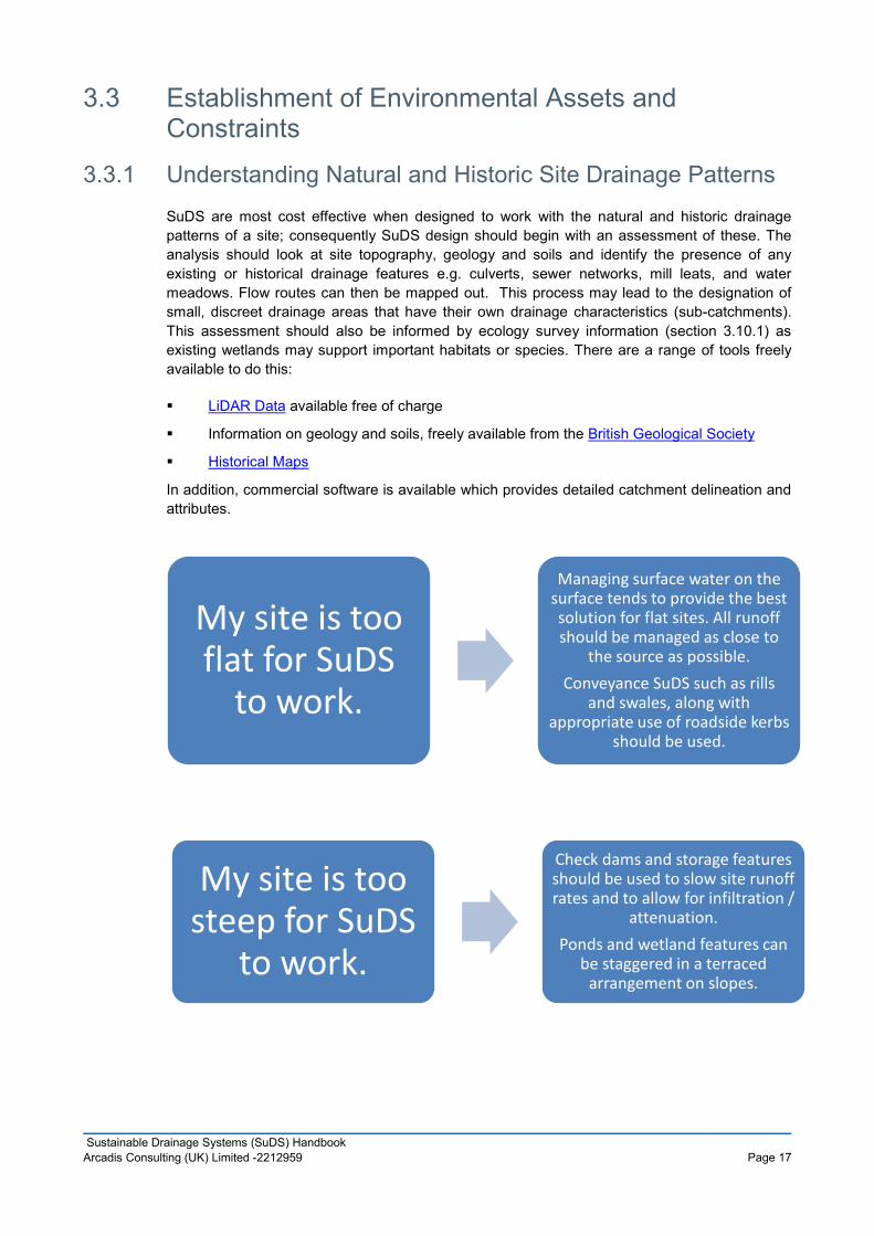
3.3 Establishment of Environmental Assets and Constraints
3.3.1 Understanding Natural and Historic Site Drainage Patterns SuDS are most cost effective when designed to work with the natural and historic drainage patterns of a site; consequently SuDS design should begin with an assessment of these. The analysis should look at site topography, geology and soils and identify the presence of any existing or historical drainage features e.g. culverts, sewer networks, mill leats, and water meadows. Flow routes can then be mapped out. This process may lead to the designation of small, discreet drainage areas that have their own drainage characteristics (sub-catchments). This assessment should also be informed by ecology survey information (section 3.10.1) as existing wetlands may support important habitats or species. There are a range of tools freely available to do this:
LiDAR Data available free of charge
Information on geology and soils, freely available from the British Geological Society
Historical Maps
In addition, commercial software is available which provides detailed catchment delineation and attributes.
My site is too flat for SuDS
to work.
Managing surface water on the surface tends to provide the best solution for flat sites. All runoff should be managed as close to
the source as possible. Conveyance SuDS such as rills
and swales, along with appropriate use of roadside kerbs
should be used.
My site is too steep for SuDS
to work.
Check dams and storage features should be used to slow site runoff rates and to allow for infiltration /
attenuation. Ponds and wetland features can
be staggered in a terraced arrangement on slopes.
Page 17 Sustainable Drainage Systems (SuDS) Handbook Arcadis Consulting (UK) Limited -2212959

3.3.2 Soil Conditions Disposal of surface water via infiltration to ground should be considered first when developing a SuDS design. Preliminary information on whether a site may be suitable for infiltration can be obtained from the British Geological Survey (BGS) Infiltration SuDS Map (chargeable data) or from LLFA specific sources listed within the relevant LLFA Appendix.
Where infiltration drainage techniques are indicated to be potentially viable, soil testing is necessary to quantify soakage rates. Guidance on undertaking these tests is available in Part H of the Building Regulations which is freely available from the Planning Portal. Note that where soakaways are proposed to serve areas above 2 hectares the testing methodology should follow BRE Digest 365 or the latest appropriate guidance should this methodology be revised. For large sites it is recommended that infiltration testing be undertaken in close proximity to where soakaways or infiltration devices would be or are likely to be placed.
BRE Digest 365 includes design guidance which states that soakaways should be designed for the 10% Annual Exceedance Probability event. Where a soakaway is designed to accommodate only the 10% Annual Exceedance Probability event, a developer must either:
Undertake an exceedance flow route exercise to ensure that flows in excess of thoseproduced by the 10% Annual Exceedance Probability event do not affect people orproperty, or;
Redesign the soakaway to cater for the 1% Annual Exceedance Probability event with anallowance for climate change (20% allowance on rainfall intensity for non-residentialdevelopments and 30% allowance on rainfall intensity for residential developments).
At sites where infiltration is not viable, the discharge hierarchy summarised in Section 3.2 should be followed and an alternative SuDS technique used. Examples are provided in Appendix D.
My soils are very clayey; SuDS won't work.
SuDS are not excluded by your ground conditions, they merely influence the choice of SuDS.
Infiltration based SuDS are unlikely to be suitable for clay
soils, however SuDS which store or convey water such as swales,
ponds and wetlands can be used.
Page 18 Sustainable Drainage Systems (SuDS) Handbook Arcadis Consulting (UK) Limited -2212959

3.3.3 Land Quality Land contamination should not be considered as rendering a site unsuitable for SuDS. Although some SuDS components may not be appropriate due to the potential for re-mobilising pollutants in the ground, there are a number of techniques which can be used. Components that store or convey water on the surface are likely to be more suitable and using liners to prevent infiltration into the underlying ground may enable the use of swales, wetlands, ponds and permeable paving.
As SuDS tend to be shallow there is likely to be less disruption to any contaminated ground during installation compared with a traditional piped drainage system.
The case study below details a successful scheme at a site where land quality was a constraint.
CASE STUDY: Welcome Break, Wheatley, Oxfordshire
These Welcome Break services occupy a 16.7 hectare site at junction 8a of the M40. SuDS were incorporated in 1997 to help manage flood risk, provide water quality improvements and add amenity value. Naturally occurring arsenic in the ground prevented the use of infiltration based drainage techniques.
Approximately 4.2 hectares of the site is roofed or paved. The roof areas drain into water features. The permeable carpark is lined and carpark runoff is treated in the sub-base, before discharging to a swale, then into a pond and reed bed. Waste water is managed using a series of lagoons and reed-beds.
Groundwater levels on my site
are very high; SuDS won't work.
SuDS are not excluded by your ground conditions, they merely influence the choice of SuDS.
The SuDS components selected should store and convey water
on the surface. Impermeable geotextile liners
can be used to limit the ingress of groundwater into a SuDS
feature.
I have contaminated groundwater on my
site; SuDS won't work
SuDS are not excluded by your ground conditions, they merely influence the choice of SuDS. Impermeable geotextile liners
should be used to limit the movement of contaminants.
Page 19 Sustainable Drainage Systems (SuDS) Handbook Arcadis Consulting (UK) Limited -2212959
The petrol station drains into a petrol interceptor, whilst the HGV park has traditional asphalt and is drained by a filter drain then into ponds and a wetland.
Total annual maintenance costs for the site are estimated at £917 for the SuDS scheme compared to £2800 for an equivalent conventional drainage scheme (based on estimates in 2001).
3.3.4 Groundwater Conditions As well as the permeability of the soil, the position of the water table beneath a development site has a bearing on the design of a SuDS scheme. For most schemes the groundwater table should be at least 1 m below the base of the SuDS component. This is necessary to ensure that there is space for a local rise in groundwater that may result from storm water infiltration. Seasonal variation in groundwater levels should also be considered. Information on groundwater levels suitable for an outline application can be obtained from the British Geological Society:
Site specific ground investigations are required for a full or reserved matters application. As well as informing the infiltration capacity of the ground, these should identify the likely groundwater table level.
In areas where groundwater levels are high, SuDS should be designed to be on the surface or shallow in depth to prevent them becoming inundated with groundwater. Liners can be used to control infiltration and the movement of groundwater where necessary.
3.4 Selection of SuDS Features Once the existing drainage characteristics of the development site are established, the SuDS features that best suit the development proposals can be selected (Appendix D). A tool which provides initial guidance on the potential for implementing SuDS on a development site is available from UK SuDS. This tool allows the key attributes and constraints relevant to the site to be specified before generating a bespoke report.
A SuDS design should be built up around the identified sub-catchments and the proposed major components of development in each sub-catchment, for example, roofs and car parking areas. Components can then be linked by surface conveyance routes, for example, in the form of rills, channels or linear wetlands and the final destination of runoff from each sub-catchment should also be determined (to ground, a watercourse, or a sewer). Opportunities should be sought to provide a betterment in water quality at all stages.
Storage should be specified as a unit volume of storage per unit area of sub-catchment to be developed.
The SuDS features and linking flow routes should provide:
Management of the first flush,
Corridors for day to day flows,
Overflows that can operate when surcharge or blockages occur, and
Exceedance pathways when exceptional rainfall overwhelms the SuDS scheme.
Page 20 Sustainable Drainage Systems (SuDS) Handbook Arcadis Consulting (UK) Limited -2212959

Management (or Treatment) Train A central design concept is the SuDS “management train”, which uses a variety of drainage techniques in series to incrementally reduce pollution, flow rates, volumes and frequency of runoff. This is illustrated in Figure 3-1.
Figure 3-1 The SuDS “management train” (Source: www.susdrain.org)
Prevention
The SuDS management train requires that surface water runoff is minimised as far as is practicable. This can be done by reducing the area of impermeable surfaces on the development site. Measures should also be put in place to reduce any pollution associated with surface water runoff such as keeping paved areas clean and containing processes likely to generate contaminants. Of particular importance is the need to capture the ‘first flush’ of contaminants which occurs when rain falls on surfaces with pollutants such as oils and petrochemicals lying on the surface. The first flow of surface water off the site will consequently wash the majority of these pollutants away resulting in a greater initial pollution load.
Measures to prevent the mis-connection of foul and storm water disposal routes and / or illicit foul connections should also be implemented at this stage. This could take the form of an inspection chamber just inside the curtilage of the development in an accessible location for sampling by environmental health officer.
Source Control
Any surface water arising after preventative measures have been implemented should be first managed at source using measures such as permeable paving, individual soakaways and localised swales.
Site Control
Surface water in excess of what can be managed using source control methods should then be managed at a site level. Site control should incorporate SuDS features capable of conveying and accommodating surface water flows from a number of source controls distributed across the development site. Examples will include swales for conveyance, ponds and basins. Such measures will further reduce and attenuate surface water flows leaving the development site.
Page 21 Sustainable Drainage Systems (SuDS) Handbook Arcadis Consulting (UK) Limited -2212959

Regional Control
Finally, a regional control may also be employed to provide one last level of quality improvement and quantity reduction. This is likely to be relevant for larger scale development sites only.
Runoff need not pass through all the stages in the management train. It could flow straight to a site control, but as a general principle it is better to deal with runoff locally, returning the water to the natural drainage system as near to the source as possible. The number of treatment stages required is dictated by the source of surface water and the sensitivity of the receiving watercourse. For example, roof runoff will be much lower in contaminants that highway runoff and will therefore require fewer treatment stages. Adding treatment stages improves the water quality as the water spends longer in treatment and consequently the opportunity for pollutant removal is enhanced.
Approaches to Water Quality Risk Management The 2015 CIRIA SuDS Manual requires that where site runoff is to be discharged to surface waters, SuDS should be designed to prevent runoff for rainfall events up to a depth of 5mm. Treatment with SuDS is essential for frequent runoff events (up to the 100% Annual Exceedance Probability) where urban contaminants are repeatedly mobilised and cumulatively contributing to pollutant loading in the receiving watercourse.
For rarer and thus larger magnitude rainfall events, it is likely that pollutants will be diluted and therefore SuDS treatment processes become less crucial. Consequently, it may be more efficient to spill higher flows from the main on-line treatment components into larger offline systems.
The SuDS design should minimise any risk of remobilisation and washout of any captured pollutants.
A Simple Index Approach (Figure 3-2) has been developed by CIRIA in order to determine the hazard posed by the site usage and how much the associated risk is reduced by the SuDS scheme. This approach is appropriate for individual property driveways, roofs, residential carparks, low traffic roads and non-residential car parking such as schools and offices (low change) discharging to surface or groundwater.
It is also suitable for commercial yard and delivery areas, non-residential car parking such as hospitals and retail (high change), and roads (excluding low traffic and motorway / trunk) discharging to surface waters. It may also be appropriate for discharge to groundwater subject to a risk screening exercise.
Full details of the assessment methodology is included within Chapter 26 of the 2015 CIRIA SuDS Manual.
Page 22 Sustainable Drainage Systems (SuDS) Handbook Arcadis Consulting (UK) Limited -2212959

Figure 3-2 Simple Index Approach (CIRIA) 1Pollution hazard indices are presented in Table 26.2 of the 2015 SuDS Manual
²SuDS pollution mitigation indices are presented in Table 26.3 and 26.4 of the 2015 SuDS Manual.
³An additional treatment component is required that provides environmental protection in the event of an unexpected pollution event or poor system performance
Local Standard B – Pollution Prevention and Control
The LLFA will expect the SuDS to demonstrate how pollutants are prevented or controlled as part of the SuDS scheme. This should include consideration of the sensitivity of receiving waterbodies and particular attention should be given to the first 5mm of rainfall (‘first flush’ that mobilises the most pollutants).
Local Standard C – Conformity with the SuDS Management Train Principles
The LLFA will expect the SuDS design to demonstrate how the principles of the SuDS Management Train have been taken into account
Box 2 Local Standards B and C
3.5 Design Criteria
3.5.1 Key Principles Detailed SuDS design guidance is freely available on the Susdrain Website and in the 2015 CIRIA SuDS Manual. Additional supporting guidance on the environmental aspects of SuDS is available from the RSPB.
The three key principles of SuDS design are given in Table 3-2.
Allocate suitable pollution hazard1 indices for the proposed land use (e.g residential / parking)
Select SuDS components with a total pollution mitigation index² that equals or exceeds the pollution hazard index
Where a SuDS scheme will discharge to protected surface waters or groundwater, the need for a more precautionary approach should be considered³
Page 23 Sustainable Drainage Systems (SuDS) Handbook Arcadis Consulting (UK) Limited -2212959

Design Criteria Key Principles
Water quantity
(hydraulics, flooding, runoff)
People and property protected from all flooding sources, including watercourses, the drainage system and overland flows.
Drainage hierarchy is followed.
Development does not exacerbate flood risk in the wider catchment.
Flow rates and volumes of runoff managed to agreed levels.
All discharge consents complied with.
Water quality (pollution control, management)
Mitigate potential pollution risks by the use of the SuDS management train.
Provide adequate retention time to enable pollutants to be treated.
Allowance made for treating the ‘first flush’.
Amenity and biodiversity Seek to positively influence urban design and landscape value through provision of green space / blue corridors, vegetation and by integrating water into the built environment, while protecting and conserving the historic environment, and providing opportunities for biodiversity.
Create SuDS which are appropriate to the distinctive local context which will enhance landscape character and quality.
Encourage multiple uses of open space.
Address and design out health and safety concerns.
Table 3-2 Summary of SuDS Design Principles
Page 24 Sustainable Drainage Systems (SuDS) Handbook Arcadis Consulting (UK) Limited -2212959

Peak flow control
S2 For greenfield developments, the peak runoff rate from the development to any highway drain, sewer or surface water body for the 100% Annual Exceedance Probability rainfall event and the 1% Annual Exceedance Probability rainfall event should never exceed the peak greenfield runoff rate for the same event.
S3 For developments which were previously developed, the peak runoff rate from the development to any drain, sewer or surface water body for the 100% Annual Exceedance Probability rainfall event and the 1% Annual Exceedance Probability rainfall event must be as close as reasonably practicable to the greenfield runoff rate from the development for the same rainfall event, but should never exceed the rate of discharge from the development prior to redevelopment for that event.
Volume control
S4 Where reasonably practicable, for greenfield development, the runoff volume from the development to any highway drain, sewer or surface water body in the 1% Annual Exceedance Probability, 6 hour rainfall event should never exceed the greenfield runoff volume for the same event.
S5 Where reasonably practicable, for developments which have been previously developed, the runoff volume from the development to any highway drain, sewer or surface water body in the 1% Annual Exceedance Probability, 6 hour rainfall event must be constrained to a value as close as is reasonably practicable to the greenfield runoff volume for the same event, but should never exceed the runoff volume from the development site prior to redevelopment for that event.
S6 Where it is not reasonably practicable to constrain the volume of runoff to any drain, sewer or surface water body in accordance with S4 or S5 above, the runoff volume must be discharged at a rate that does not adversely affect flood risk.
Box 3 National Standards for Peak Flow and Volume Control
Designing for Exceedance As a result of extreme rainfall, the capacity of a SuDS system will be exceeded from time to time; when the rate of surface water runoff exceeds the inlet capacity of the system, when the pipe system becomes overloaded, when the outfall becomes restricted due to flood levels in the receiving watercourse or when a blockage occurs.
SuDS systems cannot always economically or sustainably be built large enough for extreme events and excess water (exceedance flow) will conveyed above ground, travelling along streets and paths, between and through buildings and across open space. Careful design of a site will ensure that these exceedance pathways are appropriately defined to reduce flood risk to people and property. Further information on this principle can be found in the CIRIA document Designing for Exceedance in Urban Drainage – Good Practice.
Local Standard D – Exceedance Flows
The LLFA will expect exceedance flows, originating from both within and outside of the development site, must be directed through areas where the risks to both people and property are minimised.
Page 25 Sustainable Drainage Systems (SuDS) Handbook Arcadis Consulting (UK) Limited -2212959

When considering exceedance routes, particular attention should be paid to: i. The position of walls, bunds and other obstructions that may direct water but
must not cause ponding ii. The location and form of buildings (e.g. terraces and linked detached properties)
that must not impede flows or cause ponding iii. The finished floor levels relative to surrounding ground
Submitted drawings and calculations must identify sources of water entering a site pre development, how flows will be routed through a site, where flows leave the site pre development and where they leave the site post development.
Box 4 Local Standard D
3.5.2 Climate Change and Urban Creep It is predicted that Climate Change is likely to increase the risk of more intense rainfall in the future and therefore all SuDS schemes must be designed to accommodate this.
Guidance from the Environment Agency (February 2016) identifies two possible scenarios for future increases in rainfall intensity, ‘Central’ and ‘Upper End’ (Table 3-3).
Total Potential Anticipated Change Over Time Frame
Scenario 2010 - 2039 2040 - 2059 2060 - 2115
Upper End 10% 20% 40%
Central 5% 10% 20%
Table 3-3 Anticipated Increases in Rainfall Intensity as a Result of Climate Change
For developments located within authorities covered by this SuDS Handbook, the 1% Annual Exceedance Probability (AEP) plus a 20 - 30% allowance for climate change for a 70 year and 100 year design life respectively should be considered. This reflects the fact that a 100 year design life will now extend beyond the latest timeframe specified by the Environment Agency guidance. The developer should advise on the expected design life of the development in order to complete this assessment. Typically the design life for a commercial development is less than for a residential development.
Urban creep is the gradual loss of permeable surfaces within urban areas which results in increased surface water runoff. Typical examples of urban creep include the creation of patios, the paving over of front gardens to generate space for parking or small scale house extensions. To ensure that SuDS schemes can cope with future demand, an allowance for urban creep must be made in the design calculations. Table 3-4 sets out the requirements.
Page 26 Sustainable Drainage Systems (SuDS) Handbook Arcadis Consulting (UK) Limited -2212959

Residential Development Density (dwellings / ha)
Change Allowance (% of impermeable area)
<= 25 10*
30 8
35 6
45 4
>=50 2
Flats and Apartments 0
Table 3-4 Urban Creep Allowance (*default value suggested by CIRIA if no other value stipulated by the LLFA)
Local Standard E – Climate Change
The LLFA will expect SuDS design to include an allowance for a 20 - 30%* increase in rainfall for a 1% Annual Exceedance Probability rainfall event in order to accommodate the 2016 Upper End climate change predictions. (*note that guidance may be subject to change and therefore the most up to date information should be referenced / clarification sought from the LLFA)
Local Standard F – Urban Creep
The LLFA will expect the SuDS design to include an allowance for an increase in impermeable area to accommodate urban creep as set out in the SuDS Handbook.
Box 5 Local Standards E and F
3.5.3 Interaction with Highway Design Guidance Design guidance for highway drainage is set out in the Design Manual for Roads and Bridges. Although highway drainage may be required only to accommodate runoff from smaller events, SuDS systems on new developments must still comply with National and Local Standards.
3.5.4 Good Urban Design SuDS should be consistent with good urban design and likewise urban design should embrace the principles of SuDS. When considering the design of a SuDS, the following points should be considered.
No space on a development site is useless, all space can have a function. This can beparticularly relevant for small scale SuDS features which can work together to create alocal network of drainage features, managing water at source within sub-catchment units(see also Chapter 3.5.4).
Creating a diverse scheme increases the quality of the feature for humans and theenvironment. When planning a development, think creatively about the types of SuDSfeatures which will work within the site (see also Chapter 3.10)
Page 27 Sustainable Drainage Systems (SuDS) Handbook Arcadis Consulting (UK) Limited -2212959

Improve connections and cohesion across the site by creating networks of SuDS featureswhich link up allowing movement not only of surface water but also of residents andwildlife (see also Chapter 3.10).
Where appropriate, SuDS should be informed by Local Planning Authority specificConservation Design Guidance, Village Design Plans and Conservation Area Appraisals.This information can be found by searching on line for the relevant Local PlanningAuthority and guidance e.g. ‘Conservation Design Guidance Local Authority Name’.
Water storage facilities should be designed to reflect natural shapes and contours so asto create a natural appearance/landscape. Highly engineered finishes and landformsshould be avoided.
3.5.5 Land Take When planning for SuDS in high density developments both innovative design and selection of appropriate components are fundamental.
Adopting green roofs and rainwater harvesting allows rainwater to be controlled as close to source as possible, attenuating the flow of runoff and providing other benefits. Permeable paving or other permeable surfaces can replace standard impermeable tarmac to reduce the amount of runoff generated. Bioretention areas can be used as landscaped features in car parks, and in areas where green space would be expected anyway.
Good design should ensure that no space is wasted and by integrating vegetated/landscaped and proprietary/more engineered components, an effective SuDS scheme that minimises land take can be delivered. However good design must also ensure that sufficient space is allowed so that features such as retention and infiltration basins and swales can be sensitively designed to deliver landscape and biodiversity enhancement.
The case study below demonstrates implementation of a successful SuDS scheme on a site where space was a significant constraint.
CASE STUDY: Riverside Court, Stamford
A disused electricity sub-station was redeveloped to achieve a housing density of 104 units a hectare built around two loosely defined courts that open directly onto shared pedestrian and vehicular space and an access street.
Vehicular surfaces in each court and the access street, together with some of the parking spaces, use permeable pavements to achieve collection, cleaning and storage of runoff in a very confined space with no land take. Roof water is collected through silt traps that flow into
I can't fit SuDS into my development
layout.
If SuDS are considered at an early stage in the development planning process, appropriate features can be employed as shown in Appendix D.
Page 28 Sustainable Drainage Systems (SuDS) Handbook Arcadis Consulting (UK) Limited -2212959

diffuser boxes within the voided stone sub-base or directly to planted rills. In some places the voided stone construction is enhanced by shallow geo-cellular drainage.
The whole pavement contributes clean water to a courtyard canal and rill before flowing through three control points into a river side canal, that reflect the three sub-catchments, identified within the development. A slot weir to the River Welland controls the flow down a stepped rill to the water’s edge.
The planted canals and rills raise the landscape quality significantly. They also provide an exceedance route through the housing development.
3.5.6 Planting Many SuDS features are vegetated and plant selection will depend upon locally native species, climate / microclimate and ground conditions. A survey of locally native species may contribute to plant selection and the LLFA specific appendix should be consulted for further details on this. New planting should, where appropriate, reflect historic landscape character in the location and scale of planting. For example in situations where a SuDS scheme sits within a previously designed landscape such as a former historic parkland.
The following factors need to be considered to ensure that systems function as designed:
1. The vegetated side slopes of SuDS features should not exceed a gradient of 1:3 in order toavoid soil slippage, the resultant non-establishment of vegetation, for health and safetyreasons and to ensure access for maintenance.
2. Landform design should be appropriate for plant colonisation e.g. shelves on the margins ofponds.
3. Planting areas should be designed to be lower than adjacent surfaces and dished whereverpossible, to avoid excessive volumes of silt washing onto permeable surfaces. Care will berequired with the design of tree pits in hard surfaces, to ensure that they do not becometoxic ‘salt traps’ following winter de-icing operations. A variety of proprietary tree productsand systems have been developed to ensure successful tree planting and establishment, aspart of SuDS schemes. Research and development continues apace in this field.
4. Consideration should be made as to how quickly and how large trees and plants will growensuring that there is sufficient space both above and below ground for the plant to develop.
5. The potential impacts of ground compaction as a result of any pedestrian or vehicularactivity should be considered as this may reduce the effectiveness with which rainwater canreach the roots and / or result in stunted growth.
6. Plants appropriate to site conditions (soil type, slope and orientation, light availability)should be selected that are suitable for the expected flow velocities and weather conditions.
7. Planting should be undertaken at the appropriate time of year and allow planting toestablish before drainage that would otherwise damage immature plants, is allowed to enterthe system.
8. The maintenance requirements of SuDs planting need to be considered. For exampleunless the feature includes deep water some plant species such as common reed andreedmace that spread rapidly should be avoided. SuDS maintenance should be included insite landscape management planning.
Page 29 Sustainable Drainage Systems (SuDS) Handbook Arcadis Consulting (UK) Limited -2212959

There are a variety of planting techniques available for use in SuDS features. Where drainage systems are to be planted, the following are options:
Use of aquatic plants placed in small groups or more densely if erosion is a concern onwater body margins;
Grass seeding (including wildflower meadow mixes), is particularly applicable forattenuation basins and swales and around ponds;
Where a dense ground cover is required quickly, planted or seeded coir mats or rolls canbe used. This avoids soil erosion and prevents soil and mulch washing into the drainagesystem.
In general fertiliser use should be avoided as this affects water quality.
3.6 Flood Risk
3.6.1 Watercourses Where a SuDS proposal relies on the use of components which attenuate and convey storm water (e.g. attenuation ponds, basins or swales), these should not be situated within Flood Zone 3 inclusive of an allowance for climate change. During a flood event, such features would be at risk of filling with fluvial floodwater thus rendering them ineffective for storm water management. SuDS design in areas at risk of river or watercourse flooding should limit use of surface features which could be washed out during a flood and should focus instead on dispersing surface water as sheet flow across the site. Discharge from the SuDS scheme must be timed to minimise the impact on the receiving watercourse relative to its response time. Consultation with the LLFA or the Environment Agency may be necessary to assess this.
High level information on river (and surface water) flooding is available from the Environment Agency. This is likely to be sufficient to inform outline applications, although the presence of small watercourses that may not have been included on the Environment Agency’s national scale Flood Map for Planning needs to be considered. These flow routes are often shown on the surface water flood mapping.
For a full application, flood risk from watercourses at or near a development site must be considered in detail by undertaking local quantitative assessments (utilising hydraulic modelling where necessary), using topographic and watercourse cross section survey and hydrological data. An assessment should incorporate peak river flows for a 1% Annual Exceedance Probability flood event, inclusive of the impacts of climate change. Such models, built using readily available hydraulic computer modelling software, can then be used to inform development site layout, finished floor levels and flood mitigation measures that may be necessary. The Environment Agency or LLFA may already hold flood model information for some watercourses that they can make available at a charge to developers.
In all cases, it is recommended that consideration of the joint probability of the occurrence of surface water flooding and high flood levels in receiving watercourses is considered.
Page 30 Sustainable Drainage Systems (SuDS) Handbook Arcadis Consulting (UK) Limited -2212959

3.6.2 Surface Water The Environment Agency publishes maps showing the risk of flooding from surface water. The methodology used in generating these maps means that they tend to highlight natural drainage paths and can therefore be used to inform the layout of SuDS features on a site. Due consideration must be given to locations where surface water flows are shown to enter a development site from outside the site boundary as additional space for storage and conveyance may be required to accommodate this. Likewise, any onsite measures should not adversely impact on surface water flow routes and volumes downstream.
Reference should also be made to the relevant Surface Water Management Plan (SWMP) for the area for any more detailed surface water modelling which may be available. Details of relevant SWMPs are included within the LLFA specific appendix. For large major developments, where surface water flooding has been shown on the national scale mapping to be a potential issue, detailed surface water flood modelling using topographic survey of the site should be undertaken for to inform full planning applications.
Flood risk within the development
S7 The drainage system must be designed so that, unless an area is designated to hold and/or convey water as part of the design, flooding does not occur on any part of the site for a 3.3% Annual Exceedance Probability rainfall event.
S8 The drainage system must be designed so that, unless an area is designated to hold and/or convey water as part of the design, flooding does not occur during a 1% Annual Exceedance Probability rainfall event in any part of: a building (including a basement); or in any utility plant susceptible to water (e.g. pumping station or electricity substation) within the development.
S9 The design of the site must ensure that, so far as is reasonably practicable, flows resulting
My site falls within Flood Zone 2 / 3; SuDS won't be an
option here.
A surface water drainage system should function effectively during the 1% AEP (with climate change allowance) event. Therefore it is not appropriate to site SuDS features which are critical to the site drainage system in these areas. SuDS which: Provide storage which is surplus to the design requirement; Have a water quality only purpose; or Are used for amenity only Are appropriate within a designated Flood Zone.
Page 31 Sustainable Drainage Systems (SuDS) Handbook Arcadis Consulting (UK) Limited -2212959

from rainfall in excess of a 1% Annual Exceedance Probability rainfall event are managed in exceedance routes that minimise the risks to people and property.
Box 6 National Standards for Management of Flood Risk within the Development
Local Standard G – Emergency Overflows
The LLFA will expect an emergency overflow to be provided for piped and storage features above the predicted water level in a 1% Annual Exceedance Probability rainfall event, with an allowance for climate change
Local Standard H – Freeboard Levels
The LLFA will expect all surface water storage ponds to provide a 300mm freeboard above the predicted water level arising from a 1% Annual Exceedance Probability rainfall event inclusive of an allowance for climate change. Care must be taken to ensure that excavations do not take place below the ground water level.
Local Standard I – Watercourse Floodplains
The LLFA will expect the floodplains of ordinary watercourses to be mapped to an appropriate level of detail considering the nature of the application (i.e. detailed flood modelling should be undertaken to support full planning applications). The layout of the development will then take a sequential approach, siting the least vulnerable parts of that development in the highest flood risk areas.
Local Standard J – Retention of Natural Drainage Features
The LLFA will expect natural drainage features on a site should be maintained and enhanced. Culverting of open watercourses will not normally be permitted except where essential to allow highways and / or other infrastructure to cross. In such cases culverts should be designed in accordance with CIRIA’s Culvert design and operation guide, (C689). Where a culverted watercourse crosses a development site, it should be reverted back to open channel. In such a case the natural conditions deemed to have existed prior to the culverting taking place should be re-instated.
Local Standard K – Impact of Downstream Water Levels
If high water levels within a receiving watercourse into which a SuDS scheme discharges are anticipated, the LLFA will expect that they will not adversely affect the function of that SuDS system. The joint probability of the occurrence of peak surface water flows with peak river levels in the receiving watercourse should be considered.
Box 7 Local Standards G, H, I, J and K
3.6.3 Sewer Flood Risk The Water and Sewerage Companies will be able to advise of flood risk from the sewerage network, either from existing public sewers crossing the development or where the connection of new development drainage may affect flood risk (e.g. low lying connections). Where a surface water connection to a public sewer may be required they will be able to provide advice as to whether there are likely to be capacity constraints on the sewerage network which may
Page 32 Sustainable Drainage Systems (SuDS) Handbook Arcadis Consulting (UK) Limited -2212959

need to be considered as part of SuDS design to ensure additional flows do not adversely impact on flood risk from the sewerage network.
3.7 Sewerage Assets It is illegal to build over or close to a public sewer without first gaining approval. Where practical, any components of a SuDS should be located at least 3m from a public sewer. Where it is not practical to relocate the SuDS feature, or divert the public sewer, a formal ‘Building Over Agreement’ will be required. This ensures that the Water and Sewerage Company can access the pipe in the event of any problems.
In order to locate any existing public sewers on the development site, the relevant Water and Sewerage Company should be consulted as identified in the LLFA specific appendix.
3.8 Designing for Maintenance and Safety Design should minimise maintenance requirements and health and safety should be appropriately managed as part of the design process. The Construction Design and Management (CDM) Regulations require all designers to identify, eliminate or control foreseeable risks that could arise at any time during the lifetime of a scheme because of its design. Therefore, the design process must include consideration of how the SuDS scheme in its entirety is to be maintained.
SuDS components should have shallow side slopes and ponds should have shallow shelving at their edges. Guidance on the selection of appropriate side slopes for different SuDS components is contained within the 2015 SuDS Manual. Good use of vegetation should be made to prevent access to open water features where required.
Pipe connectors should be shallow and short, allowing simple jetting to keep them clear. Inlets, outlets and control structures should be at or near the surface to allow day to day care by landscape contractors or site managers. Inspection points which are easy to access should be incorporated.
Chapter 36 of the 2015 SuDS Manual provides guidance on managing the safety risk associated with SuDS, information is also available on the ROSPA website. Risks should be identified and managed through the use of an appropriate risk assessment. A template Health and Safety Risk Assessment is provided in Appendix B3 of the 2015 SuDS Manual.
Structural integrity
S10 Components must be designed to ensure structural integrity of the drainage system and any adjacent structures or infrastructure under anticipated loading conditions over the design life of the development taking into account the requirement for reasonable levels of maintenance.
S11 The materials, including products, components, fittings or naturally occurring materials, which are specified by the designer must be of a suitable nature and quality for their intended use.
Designing for maintenance considerations
S12 Pumping should only be used to facilitate drainage for those parts of the site where it is not reasonably practicable to drain water by gravity.
Construction
Page 33 Sustainable Drainage Systems (SuDS) Handbook Arcadis Consulting (UK) Limited -2212959

S13 The mode of construction of any communication with an existing sewer or drainage system must be such that the making of the communication would not be prejudicial to the structural integrity and functionality of the sewerage or drainage system.
S14 Damage to the drainage system resulting from associated construction activities must be minimised and must be rectified before the drainage system is considered to be completed.
Box 8 National Standards for Safety, Construction and Maintenance
Local Standard L – Maintenance Requirements
The LLFA will expect SuDS to be designed so that they are easy to maintain. Proper use of the SuDS management train, including surface features, is one way to achieve this.
The developer must set out who will maintain the system, how the maintenance will be funded and provide a maintenance and operation manual.
Local Standard M – Minimising the Risk of Blockages
The LLFA will expect the SuDS design to minimise the risk of blockage as far as is reasonably possible e.g. by using suitable pipe sizes and making underground assets as visible and accessible as possible.
Local Standard N – Use of Pumped Systems
If it can be demonstrated that a partial or completely pumped drainage system is the only viable option, the LLFA will expect the residual risk of flooding due to the failure of the pumps to be assessed. The design flood level must be determined under the following conditions:
If the pumps were to fail If the attenuation storage was full, and If a design storm occurred.
The finished floor levels of the affected properties should be raised above this level and all flooding should be safely stored onsite. An emergency overflow must be provided for piped and storage features above the predicted water level arising from a 1% Annual Exceedance Probability rainfall event inclusive of allowances for climate change and urban creep.
Box 9 Local Standards L, M and N
3.9 Historic Environment The historic environment is comprised of buried archaeological remains (and the remains of upstanding earthworks), historic buildings and structures and historic landscape character. Some heritage assets have been identified as being of national importance and are statutorily designated. Details of nationally designated heritage assets can be identified on the government’s National Heritage List for England. A SuDS scheme may impact on significant
Page 34 Sustainable Drainage Systems (SuDS) Handbook Arcadis Consulting (UK) Limited -2212959

heritage assets and therefore consent for the works must be sought at an early stage. Further information on these can be found on the Historic England website.
Undesignated heritage assets are usually recorded in a county (or equivalent) Historic Environment Record (HER); this record is not exhaustive as heritage assets may come to light at any time and therefore contact should be made with the relevant officer as set out in the LLFA specific appendix. These assets may be as significant as designated heritage assets but are considered as part of the planning process rather than as separate consented works.
Developers should identify the presence of heritage assets during the planning stage and make the presence of these clear to the LLFA, where they have the potential to inform or affect the drainage of the site. This will enable the LLFA to liaise with relevant organisations and colleagues to ensure the SuDS system is in keeping with the historic setting of the site, where appropriate. Developers should also ensure that the design of a SuDS system does not have a detrimental impact on any heritage assets. Opportunities for SuDS schemes to enhance the historic environment shall be explored. Further information is contained within the LLFA specific appendix.
3.10 Delivering Multiple Benefits Well planned SuDS will deliver multiple environmental, social and economic benefits. In addition to managing flows, volumes, and diffuse pollution, some components (particularly vegetated or landscaped features) can positively impact air quality, carbon reduction, recreation, education and other elements of community health and vitality, having monetary or intangible social value. CIRIA has developed a freely available tool with associated guidance which makes it easier to assess the benefits of SuDS. The BeST (Benefits of SuDS Tool) can be accessed via the Susdrain website.
In designing SuDS features, the developer should consider how these could be co-located with open space and public areas to create multi-functional spaces. By integrating SuDS features with other street features such as traffic calming measures, parking bays and verges, opportunities to improve the streetscape are presented.
Where a new development is proposed on existing undeveloped land, it may be that existing land drainage features are present e.g. field drainage ditches, minor ponds or elements of surviving historic water management e.g. mill leats, water meadows. These present opportunities to manage surface water via existing pathways and also to enhance their attributes e.g. by improving conveyance or habitat potential. Care should be taken to accommodate any existing drainage functions.
Local Standard O Multiple Benefits
The SuDS design must demonstrate, where appropriate, how environmental site constraints have been considered and how the features design will provide multiple benefits e.g. landscape enhancement, biodiversity, recreation, amenity, leisure and the enhancement of historical features.
Box 10 Local Standard O
3.10.1 Wildlife and Biodiversity Any development site has potential to support habitats and/or species of importance for biodiversity; guidance can be found in British Standard BS42020:2013 Biodiversity. Code of
Page 35 Sustainable Drainage Systems (SuDS) Handbook Arcadis Consulting (UK) Limited -2212959

Practice for Planning and Development. Proposed SuDS schemes should be informed by appropriate ecological surveys and assessments in line with the relevant LLFA policies and guidance, details of which can be found in the LLFA specific appendices. The location and design of SuDS should be informed by surrounding habitats and land-uses with an aim of contributing to green infrastructure and provision of features of value for wildlife to help species breed, feed and move through the landscape. Opportunities to create wildlife habitats that can be enjoyed by residents should be demonstrated. Even very small scale features such as green roofs and water gardens can provide wildlife benefit.
Biodiversity Opportunity maps are developed to highlight where priority habitats can be enhanced, restored or created in a particular area, county or region. They are used as a basis from which to develop policies and targets. Details on Biodiversity Opportunity mapping within each LLFA is contained within the specific appendix.
A variety of initiatives focused on improving and restoring ponds across the UK are in existence and the contribution of a SuDS scheme to these should be explored.
It is recommended that ecological advice be taken when designing SuDS and deciding on planting schemes. Well designed and maintained SuDS can become valuable features within site greenspace.
3.10.2 Trees Trees, particularly long-lived, large-canopied species, are important and often defining components of the rural landscape or urban ‘streetscene’, conferring a wealth of social, economic and environmental benefits. Trees and woodland can play an active part in SuDS through canopy interception of rain and root uptake of water from the soil, which attenuates surface water run-off by decreasing peak flow rate and volume.
The British Standard ‘BS5837:2012 Trees in relation to design, demolition and construction - Recommendations’ provides guidance on deciding, in relation to planning applications, which trees are appropriate for retention, on the effect of trees on design and layout considerations and on the means of protecting trees during development. Care should be taken during the design and construction of the SuDS scheme that this guidance is adhered to and that designs maximise the opportunity to maintain existing tree cover where appropriate and enhance future cover through new planting. Trees (and their requirement for suitable rooting volume and canopy space) should be considered as an integral part of SuDS from the earliest stages of project concept and design.
3.10.3 Public Open Space and Amenity The requirement to provide Public Open Space on all new developments presents an excellent opportunity for the provision of SuDS as many of the integral system features can function as green parks, wildlife corridors and gardens. Good SuDS design will ensure that systems act as truly multifunctional spaces and will avoid poorly conceived design features such as steep sided, fenced basins.
It is highlighted however that not all SuDS will contribute to Public Open Space; for example the requirement to provide functioning or usable open space specifically for sport, recreation and leisure activities may not always be offset against the requirements to include SuDS within a development. Details on Public Open Space requirements may be set out in Site Allocations and Management of Development (SAMDev) Plan policies. The relevant Local Planning Authority should be contacted to determine what and how much of a SuDS scheme can
Page 36 Sustainable Drainage Systems (SuDS) Handbook Arcadis Consulting (UK) Limited -2212959

contribute to the Public Open Space. Further information can be found in the LLFA specific appendix.
3.10.4 Landscape Many developments are likely to be in an urban setting or part of proposals that create new urban environments. Good design should be informed by local character and distinctiveness as well as the historic landscape character and historic built environment, and should contribute to a sense of place. For greenfield development sites and development within and around villages and small towns, the full context of the site and its surroundings should be considered to inform design through reference to Local Landscape Character Assessments. Where relevant, landscape architects and historic environment specialists should work together to develop an appropriate design strategy for the SuDS. Reference should also be made to local design and development guides as well as any relevant Supplementary Planning Documents (SPD).
National Character Areas have been defined for 159 major landscape areas in England. They utilise a variety of environmental information to create a profile for each landscape area which sets out the landscape, wildlife, cultural and geological features in conjunction with information on the local environmental opportunities for the future. This information is freely available from the Gov.uk National Character Area Profiles and identifies opportunities for enhancement within each character area.
The information provided on opportunities within the National Character Area along with an understanding of the local character should be used to guide the SuDS strategy in order to deliver landscape and biodiversity enhancement. This may extend to choice of vegetation, use of buffer strips alongside watercourses and the types of features use e.g. ponds to encourage key wildlife species. Where detailed design requires hard engineering then this should use materials appropriate to the locality. Soft landscape solutions should use grass seed and planting mixes that are ecologically appropriate, although in some urban situations a combination of native and ornamental species may be acceptable.
Further LLFA specific information is included within the relevant appendix.
3.11 Water Quality and the Water Framework Directive River Basin Management Plans are subject to a six year review cycle; the last review took place in 2015 and the next review is scheduled for 2021. The information below and in the LLFA appendices represents the situation in 2016.
3.11.1 Key Water Framework Directive Objectives The Water Framework Directive, established in October 2000, is a piece of European Union legislation with the aim of preserving, restoring and improving the water environment. The key environmental objectives of the directive are:
All surface water bodies to achieve good ecological and chemical status by 2015. Thiscovers inland waters, transitional waters (estuaries) and coastal waters.
All groundwater bodies to achieve good groundwater quantitative and chemical status by2015.
Heavily-modified water bodies and artificial water bodies to achieve good ecologicalpotential and good surface water chemical status by 2015.
No water bodies to experience deterioration in status from one class to another.
Page 37 Sustainable Drainage Systems (SuDS) Handbook Arcadis Consulting (UK) Limited -2212959

Protected Areas to achieve the requirements made under their designation in relation tothe water environment.
The second cycle (2016 – 2021) of the Water Framework Directive is now underway and a review of the Directive is expected in 2019. The current expectation from the Environment Agency is that 60% of waters will achieve ‘good’ status by 2021.
3.11.2 River Basin Management Plans The basic unit at which the Directive is implemented is the River Basin District and management plans have been developed for each district which set statutory objectives for the water bodies within them. These river basin level objectives contribute to meeting the overall objectives of the Directive.
The nine LLFA’s covered by this Handbook are located predominantly within the Severn and Humber River Basin Districts and associated River Basin Management plans. River basins are divided into catchments, enabling more specific objectives to be defined.
Information on the current and future chemical and ecological status of a watercourse can be found via the Environment Agency online maps. This information should be used in conjunction with the information in Section 3.4 to determine the most appropriate approach to water quality management.
3.11.3 Role of SuDS in Meeting Water Framework Directive Objectives Using SuDS to manage surface water plays an important role in preventing the pollution of water bodies from surface water runoff. The implementation of the SuDS approach for the drainage for new developments will ensure that these sites cannot contribute to the degradation in the quality of surface or ground water. Specific reference is made to the role of SuDS within the River Basin Management Plans and the objectives of relevance to the LLFA’s covered by this Handbook are included within the LLFA specific appendix.
3.12 Designation of SuDS Constructed on Third Party Land The Flood and Water Management Act 2010 enables LLFAs to designate features or structures, constructed on third party land, which may impact on flood risk, at their discretion. All designated structures will be recorded onto an asset database. This process may be used to designate private SuDS serving new developments. Once a SuDS feature has been designated and placed on the asset register, formal consent from the LLFA will be required for any changes.
No action on the part of the developer is required; all decisions relating to the designation of SuDS will be made by the LLFA.
3.13 Riparian Responsibilities Anyone owning land or property next to a river, stream or ditch is classed as a riparian landowner and has associated rights and responsibilities.
Wherever possible, watercourses should be made features of development sites and integrated into the overall drainage system. This includes opening up culverted watercourses where this
Page 38 Sustainable Drainage Systems (SuDS) Handbook Arcadis Consulting (UK) Limited -2212959

would not increase flood risk to others up or downstream. Access to maintain a watercourse should be provided at all times and buildings should not be placed directly on the banks of watercourses. Future owners of properties who will have riparian responsibilities should be made aware of these when purchasing properties.
Further details and explanation of all rights and responsibilities pertaining to riparian ownership can be found in the Environment Agency’s publication ‘Living on the Edge: A Guide to Your Rights and Responsibilities of Riverside Ownership’.
3.14 Useful Resources & References The following publications and tools provide further detailed guidance on Sustainable Drainage Systems (SuDS):
Sustainable Drainage Systems Non-statutory technical standards for sustainable drainage systems. Available from https://www.gov.uk/government/publications/sustainable-drainage-systems-non-statutory-technical-standards
CIRIA C687 – Planning for SuDS: Making it Happen http://www.ciria.org/Resources/Free_publications/Planning_for_SuDS_ma.aspx
CIRIA C753 – The SuDS Manual http://www.ciria.org/Resources/Free_publications/SuDS_manual_C753.aspx
Susdrain – The Community for Sustainable Drainage www.susdrain.org
UK SuDS Tools website – www.uksuds.com
Sustainable Drainage Systems: Maximising Potential for People and Wildlife http://www.rspb.org.uk/Images/SuDS_report_final_tcm9-338064.pdf
Engineering Nature’s Way http://www.engineeringnaturesway.co.uk/
Dwr Cymru Welsh Water Surface Water Management Strategy http://www.dwrcymru.com/_library/leaflets_publications_english/surface_water_management_strategy.pdf
United Utilities SuDS http://www.unitedutilities.com/suds-sustainable-drainage-systems%20.aspx
Natural England Green Infrastructure Guidance http://publications.naturalengland.org.uk/publication/35033 (although it refers to policy that has been superseded by the NPPF it is still a useful reference document).
Landscape Institute Technical Guidance Note: Management and maintenance of Sustainable Drainage Systems (SuDS) Landscapes http://www.landscapeinstitute.org/PDF/Contribute/SUDSmanagementMar2014.pdf
LLFA specific links are included within the relevant appendices.
Page 39 Sustainable Drainage Systems (SuDS) Handbook Arcadis Consulting (UK) Limited -2212959
Page 40 Sustainable Drainage Systems (SuDS) Handbook Arcadis Consulting (UK) Limited -2212959
Page Intentionally Blank

Page 41 Sustainable Drainage Systems (SuDS) Handbook Arcadis Consulting (UK) Limited -2212959
Page Intentionally Blank

Appendix A
Surface Water Drainage Proforma The table below sets out the evidence required within the SuDS submission to demonstrate that both the National Standards and Local Standards have been complied with. The developer should complete the highlighted text boxes in the proforma.
(* dependent on options for surface water disposal, ** at outline stage it should be demonstrated that consideration has been given to how the SuDS scheme will be maintained throughout its lifetime, ***at outline stage it should be demonstrated that access is feasible)
Applicant Name
Planning Application Name
Application Type (please circle) Outline Full
1. Site Context
Evidence Required
Req
uire
d fo
r O
utlin
e Pl
anni
ng
Req
uire
d fo
r Ful
l Pl
anni
ng
Complied With? Evidence Supplied
1.1 Site location plan Y Y
Page 42 Sustainable Drainage Systems (SuDS) Handbook Arcadis Consulting (UK) Limited -2212959

1.2 Detailed site layout plan at an identified scale with a north arrow
Y
1.3 Topographical survey of the site, including cross sections of any adjacent watercourses for an appropriate distance upstream and downstream of the proposed discharge point
Y
1.4 Survey and assessment of Environmental Constraints (identified historic (designated and undesignated), ecological (designated sites, habitats and species) and tree constraints and landscape context.
Y
2. Design PrinciplesLocal Standards
Local Standard A – Phased Development and Drainage Strategies
For phased developments, the LLFA will expect planning applications to be accompanied by a Drainage Strategy which takes a strategic approach to drainage provision across the entire site and incorporates adequate provision for SuDS within each phase.
Local Standard B – Pollution Prevention and Control
The LLFA will expect the SuDS to demonstrate how pollutants are prevented or controlled as part of the SuDS scheme. This should include consideration of the sensitivity of receiving waterbodies and particular attention should be given to the first 5mm of rainfall (‘first flush’ that mobilises the most pollutants).
Local Standard C – Conformity with the SuDS Management Train Principles
The LLFA will expect the SuDS design to demonstrate how the principles of the SuDS Management Train have been taken into account
Local Standard O – Multiple Benefits
The LLFA will expect the SuDS design to demonstrate, where appropriate, how environmental site constraints have been considered and how the features design will provide multiple benefits e.g. landscape enhancement, biodiversity, recreation, amenity, leisure and the enhancement of historical features.
Page 43 Sustainable Drainage Systems (SuDS) Handbook Arcadis Consulting (UK) Limited -2212959

Evidence Required
Req
uire
d fo
r O
utlin
e Pl
anni
ng
Req
uire
d fo
r Ful
l Pl
anni
ng
Complied With? Evidence Supplied
2.1 Concept drainage strategy and masterplan demonstrating how SuDS have been incorporated into the site design and how the SuDS system complies with the SuDS Management Train
Y Y
2.2 Demonstration that a suitable route for disposal of surface water is feasible and that relevant ‘in principle’ permissions have been granted.
Y
2.3 Plan of the proposed drainage system showing catchment areas including impermeable areas and phasing
Y
2.4 Review of multiple benefits provided by the SuDS scheme using the BeST Tool or another method as appropriate
Y Y
2.5 Development phasing plan demonstrating how the SuDS scheme will be implemented
Y
2.6 Plan showing any existing drainage pathways on the site (including surface water flow paths, ditches, depressions and watercourses and historic drainage features such as drains, leats, water meadows, culverts etc.) and information as to how these are to be incorporated / managed within the wider SuDS scheme.
Y Y
Page 44 Sustainable Drainage Systems (SuDS) Handbook Arcadis Consulting (UK) Limited -2212959

2.7 Long sections and cross sections for the proposed SuDS system
Y
2.8 Details of connections (including flow control devices) to watercourses, sewers, public surface water sewers and highway drains
Y Y
2.9 Results of ground investigations or desk top studies / permeability assessment, including infiltration testing where appropriate
Y* Y
2.10 Assessment of SuDS system water quality performance
Y Y
2.11 Landscape planting scheme where a vegetated SuDS scheme is proposed
Y
3. Peak Flow ControlApplicable National Standards S2 For greenfield developments, the peak runoff rate from the development to any highway drain, sewer or surface water body for the 100% Annual Exceedance Probability rainfall event and the 1% Annual Exceedance Probability rainfall event should never exceed the peak greenfield runoff rate for the same event.
S3 For developments which were previously developed, the peak runoff rate from the development to any drain, sewer or surface water body for the 100% Annual Exceedance Probability rainfall event and the 1% Annual Exceedance Probability rainfall event must be as close as reasonably practicable to the greenfield runoff rate from the development for the same rainfall event, but should never exceed the rate of discharge from the development prior to redevelopment for that event.
Page 45 Sustainable Drainage Systems (SuDS) Handbook Arcadis Consulting (UK) Limited -2212959

Evidence Required
Req
uire
d fo
r O
utlin
e Pl
anni
ng
Req
uire
d fo
r Ful
l Pl
anni
ng
Complied With? Evidence Supplied
3.1 Details of pre and post development runoff rates for 100% and 1% Annual Exceedance Probability rainfall events sufficient to demonstrate that the proposed SuDS system should operate as designed
Y Y
3.2 Full design calculations to demonstrate conformity with the national non-statutory technical standards for SuDS and Local Standards
Y
4. Volume ControlApplicable National Standards S4 Where reasonably practicable, for greenfield development, the runoff volume from the development to any highway drain, sewer or surface water body in the 1% Annual Exceedance Probability, 6 hour rainfall event should never exceed the greenfield runoff volume for the same event.
S5 Where reasonably practicable, for developments which have been previously developed, the runoff volume from the development to any highway drain, sewer or surface water body in the 1% Annual Exceedance Probability, 6 hour rainfall event must be constrained to a value as close as is reasonably practicable to the greenfield runoff volume for the same event, but should never exceed the runoff volume from the development site prior to redevelopment for that event.
S6 Where it is not reasonably practicable to constrain the volume of runoff to any drain, sewer or surface water body in accordance with S4 or S5 above, the runoff volume must be discharged at a rate that does not adversely affect flood risk.
Local Standards
Page 46 Sustainable Drainage Systems (SuDS) Handbook Arcadis Consulting (UK) Limited -2212959

Local Standard E – Climate Change
The LLFA will expect SuDS design to include an allowance for a 20 - 30%* increase in rainfall for a 1% Annual Exceedance Probability rainfall event in order to accommodate the 2016 Upper End climate change predictions. (*note that guidance may be subject to change and therefore the most up to date information should be referenced / clarification sought from the LLFA)
Local Standard F – Urban Creep
The LLFA will expect the SuDS design to include an allowance for an increase in impermeable area to accommodate urban creep as set out in the SuDS Handbook.
Local Standard G – Emergency Overflows
The LLFA will expect an emergency overflow to be provided for piped and storage features above the predicted water level in a 1% Annual Exceedance Probability rainfall event, with an allowance for climate change
Local Standard H – Freeboard Levels
The LLFA will expect all surface water storage ponds to provide a 300mm freeboard above the predicted water level arising from a 1% Annual Exceedance Probability rainfall event inclusive of an allowance for climate change. Care must be taken to ensure that excavations do not take place below the ground water level.
Evidence Required R
equi
red
for
Out
line
Plan
ning
Req
uire
d fo
r Ful
l Pl
anni
ng
Complied With? Evidence Supplied
4.1 Details of pre and post development runoff volumes for 1% Annual Exceedance Probability rainfall events plus an allowance of 30% for climate change and up to a 10% increase in impermeable area to account for urban creep.
Y Y
4.2 Drawings showing location, dimensions and levels of emergency overflows provided for piped and storage features.
Y
Page 47 Sustainable Drainage Systems (SuDS) Handbook Arcadis Consulting (UK) Limited -2212959

5. Flood Risk Within the DevelopmentApplicable National Standards
Page 48 Sustainable Drainage Systems (SuDS) Handbook Arcadis Consulting (UK) Limited -2212959

S7 The drainage system must be designed so that, unless an area is designated to hold and/or convey water as part of the design, flooding does not occur on any part of the site for a 3.3% Annual Exceedance Probability rainfall event.
S8 The drainage system must be designed so that, unless an area is designated to hold and/or convey water as part of the design, flooding does not occur during a 1% Annual Exceedance Probability rainfall event in any part of: a building (including a basement); or in any utility plant susceptible to water (e.g. pumping station or electricity substation) within the development.
S9 The design of the site must ensure that, so far as is reasonably practicable, flows resulting from rainfall in excess of a 1% Annual Exceedance Probability rainfall event are managed in exceedance routes that minimise the risks to people and property.
Local Standards Local Standard D – Exceedance Flows
The LLFA will expect exceedance flows, originating from both within and outside of the development site, must be directed through areas where the risks to both people and property are minimised.
When considering exceedance routes, particular attention should be paid to
i. The position of walls, bunds and other obstructions that may direct water but must not cause ponding
ii. The location and form of buildings (e.g. terraces and linked detached properties) that must not impede flows or cause ponding
iii. The finished floor levels relative to surrounding ground
Local Standard I – Watercourse Floodplains
The LLFA will expect the floodplains of ordinary watercourses to be mapped to an appropriate level of detail considering the nature of the application (i.e. detailed flood modelling should be undertaken to support full planning applications). The layout of the development will then take a sequential approach, siting the least vulnerable parts of that development in the highest flood risk areas.
Local Standard J – Retention of Natural Drainage Features
The LLFA will expect natural drainage features on a site should be maintained and enhanced. Culverting of open watercourses will not normally be permitted except where essential to allow highways and / or other infrastructure to cross. In such cases culverts should be designed in accordance with CIRIA’s Culvert design and operation guide, (C689).
Where a culverted watercourse crosses a development site, it should be reverted back to open channel. In such a case the natural conditions deemed to have existed prior to the culverting taking place should be re-instated.
Local Standard K – Impact of Downstream Water Levels
If high water levels within a receiving watercourse into which a SuDS scheme discharges are anticipated, the LLFA will expect that they will not adversely affect the function of that SuDS system. The joint probability of the occurrence of peak surface water flows with peak river levels in the receiving watercourse
Page 49 Sustainable Drainage Systems (SuDS) Handbook Arcadis Consulting (UK) Limited -2212959

Evidence Required
Req
uire
d fo
r O
utlin
e Pl
anni
ng
Req
uire
d fo
r Ful
l Pl
anni
ng
Complied With? Evidence Supplied
5.1 Details showing that the drainage is sufficient to accommodate a 3.3% Annual Exceedance Probability rainfall event
Y
5.2 Details showing that flooding does not occur in a building or susceptible utility plant in a 1% Annual Exceedance Probability rainfall event including appropriate allowances for climate change and urban creep.
Y
5.3 Details of exceedance flow routes designed to minimise flood risk to people and property. Flow routes should also account for any potential blockage of structures.
Y
5.4 Drawings identifying sources of water entering the site pre development
Y Y
5.5 Drawings demonstrating how surface water flows are routed through the site pre development i.e. existing channels and culverts
Y Y
5.6 Drawings demonstrating how surface water flows are routed through the site post development including opportunities for daylighting existing culverts
Y Y
5.7 Drawings identifying where surface water flows leave the site pre development
Y Y
Page 50 Sustainable Drainage Systems (SuDS) Handbook Arcadis Consulting (UK) Limited -2212959

5.8 Drawings identifying where surface water flows leave the site post development
Y Y
5.9 Plan demonstrating flooded areas for the 1% annual exceedance probability (1 in 100 annual chance) storm, including the appropriate allowance for climate change and urban creep, when the system is at capacity and illustrating flow paths for design for exceedance
Y
5.10 Plans showing the location of the Flood Zones associated with ordinary watercourses on the site
Y Y
5.11 Assessment of the impacts of high water levels in receiving watercourses on the operation of SuDS scheme
Y
5.12 Copy of your Flood Risk Assessment (where required by the National Planning Policy Framework (NPPF)) (Please note that for those sites not requiring a FRA, the developer will be required to submit the other supporting information in this table to enable the LLFA to consider the proposed SuDS system in line with the National Standards and Local Standards.)
Y Y
6. Structural IntegrityApplicable National Standards S10 Components must be designed to ensure structural integrity of the drainage system and any adjacent structures or infrastructure under anticipated loading conditions over the design life of the development taking into account the requirement for reasonable levels of maintenance.
S11 The materials, including products, components, fittings or naturally occurring materials, which are specified by the designer must be of a suitable nature and quality for their intended use.
Page 51 Sustainable Drainage Systems (SuDS) Handbook Arcadis Consulting (UK) Limited -2212959

Evidence Required
Req
uire
d fo
r O
utlin
e Pl
anni
ng
Req
uire
d fo
r Ful
l Pl
anni
ng
Complied With? Evidence Supplied
6.1 Technical specifications of drainage design components including design life
Y
6.2 Loading calculations for drainage system components
Y
6.3 Category 0 Approval for structures with a diameter greater than 900mm
Y
7. Designing for Maintenance ConsiderationsApplicable National Standards S12 Pumping should only be used to facilitate drainage for those parts of the site where it is not reasonably practicable to drain water by gravity.
Local Standards
Page 52 Sustainable Drainage Systems (SuDS) Handbook Arcadis Consulting (UK) Limited -2212959

Local Standard L – Maintenance Requirements
The LLFA will expect SuDS to be designed so that they are easy to maintain. Proper use of the SuDS management train, including surface features, is one way to achieve this.
The developer must set out who will maintain the system, how the maintenance will be funded and provide a maintenance and operation manual.
Local Standard M – Minimising the Risk of Blockages
The LLFA will expect the SuDS design to minimise the risk of blockage as far as is reasonably possible e.g. by using suitable pipe sizes and making underground assets as visible and accessible as possible.
Local Standard N – Use of Pumped Systems
If it can be demonstrated that a partial or completely pumped drainage system is the only viable option, the LLFA will expect the residual risk of flooding due to the failure of the pumps to be assessed. The design flood level must be determined under the following conditions If the pumps were to fail,
If the attenuation storage was full,
If a design storm occurred.
The finished floor levels of the affected properties should be raised above this flood level and all flooding safely stored onsite.
An emergency overflow must be provided for piped and storage features above the predicted water level arising from a 1% Annual Exceedance Probability rainfall event inclusive of allowances for climate change and urban creep.
Evidence Required
Req
uire
d fo
r O
utlin
e Pl
anni
ng
Req
uire
d fo
r Ful
l Pl
anni
ng
Complied With? Evidence Supplied
7.1 Justification for use of pumps within a SuDS scheme where applicable
Y Y
Page 53 Sustainable Drainage Systems (SuDS) Handbook Arcadis Consulting (UK) Limited -2212959

7.2 Maintenance and Operation Manual for the SuDS Scheme at an appropriate level of detail. To include as a minimum responsible party and funding method
Y Y
7.3 Management plan and proposed contractual arrangements for the management of the drainage scheme over its lifetime
Y** Y
7.4 Maintenance access arrangements for all proposed drainage systems
Y*** Y
7.5 Operational characteristics of any mechanical features including maintenance and energy requirements
Y
7.6 Risk assessment demonstrating how the risk of blockages has been minimised
Y
7.7 Assessment of residual flood risk in the event of pump failure based on parameters above.
Y
8. ConstructionApplicable National Standards S13 The mode of construction of any communication with an existing sewer or drainage system must be such that the making of the communication would not be prejudicial to the structural integrity and functionality of the sewerage or drainage system.
S14 Damage to the drainage system resulting from associated construction activities must be minimised and must be rectified before the drainage system is considered to be completed.
Page 54 Sustainable Drainage Systems (SuDS) Handbook Arcadis Consulting (UK) Limited -2212959

Evidence Required
Req
uire
d fo
r O
utlin
e Pl
anni
ng
Req
uire
d fo
r Ful
l Pl
anni
ng
Complied With? Evidence Supplied
8.1 Construction drawings prepared by a suitably competent Engineer giving details of proposed elevations, dimensions, materials to be used and detailing how the proposed SuDS scheme will connect to an existing drainage system.
Y
8.2 Plan for the management of construction impacts including any diversions, erosion control, phasing and maintenance period (pre adoption)
Y
8.3 Construction Health and Safety Plan where appropriate. This should be in proportion to the risks involved in the project. Reference may be made to the HSE considering in particular open water, confined spaces and underground services
Y
8.4 Details of any offsite works required, together with any necessary consents
Y
8.4 Risk assessment which demonstrates how the construction methodology will minimise damage to existing assets.
Y
8.6 Contingency plan which demonstrates how any damage to existing assets will be resolved.
Y
Page 55 Sustainable Drainage Systems (SuDS) Handbook Arcadis Consulting (UK) Limited -2212959

Land Searches The following information is required in order that a response to future Land Search requests submitted to the Local Planning Authority can be supplied as appropriate.
Question Answer Supporting Documentation Required 1. Will all properties on the development be served
by a SuDS system?Yes / No
If no, please identify on a plan or by address, those properties which are served by a SuDS system.
2. Do any properties on the development haveSuDS features within their boundary?
Yes / No
Please identify on a plan, or by address, properties which have SuDS features within their boundary.
For the properties identified, please highlight those for which the owner is responsible for the maintenance.
3. Do any properties benefit from a SuDS systemfor which there is a charge?
Yes / No
For those properties benefiting from a SuDS system for which there is a charge, please state who is responsible for billing the property for this charge.
Page 56 Sustainable Drainage Systems (SuDS) Handbook Arcadis Consulting (UK) Limited -2212959
Page 57 Sustainable Drainage Systems (SuDS) Handbook Arcadis Consulting (UK) Limited -2212959
Page Intentionally Blank

Appendix B
Local Standards Design Principles Local Standard A – Phased Development and Drainage Strategies
For phased developments, the LLFA will expect planning applications to be accompanied by a Drainage Strategy which takes a strategic approach to drainage provision across the entire site and incorporates adequate provision for SuDS within each phase.
Local Standard B – Pollution Prevention and Control
The LLFA will expect the SuDS to demonstrate how pollutants are prevented or controlled as part of the SuDS scheme. This should include consideration of the sensitivity of receiving waterbodies and particular attention should be given to the first 5mm of rainfall (‘first flush’ that mobilises the most pollutants).
Local Standard C – Conformity with the SuDS Management Train Principles
The LLFA will expect the SuDS design to demonstrate how the principles of the SuDS Management Train have been taken into account
Local Standard D – Exceedance Flows
The LLFA will expect exceedance flows, originating from both within and outside of the development site, must be directed through areas where the risks to both people and property are minimised.
When considering exceedance routes, particular attention should be paid to:
i. The position of walls, bunds and other obstructions that may direct water but must not causeponding
ii. The location and form of buildings (e.g. terraces and linked detached properties) that must notimpede flows or cause ponding
iii. The finished floor levels relative to surrounding ground
Submitted drawings and calculations must identify sources of water entering a site pre development, how flows will be routed through a site, where flows leave the site pre development and where they leave the site post development.
Volume Control Local Standard E – Climate Change
The LLFA will expect SuDS design to include an allowance for a 20 - 30%* increase in rainfall for a 1% Annual Exceedance Probability rainfall event in order to accommodate the 2016 Upper End climate change predictions. (*note that guidance may be subject to change and therefore the most up to date information should be referenced / clarification sought from the LLFA)
Page 58 Sustainable Drainage Systems (SuDS) Handbook Arcadis Consulting (UK) Limited -2212959

Local Standard F – Urban Creep
The LLFA will expect the SuDS design to include an allowance for an increase in impermeable area to accommodate urban creep as set out in the SuDS Handbook.
Local Standard G – Emergency Overflows
The LLFA will expect an emergency overflow to be provided for piped and storage features above the predicted water level in a 1% Annual Exceedance Probability rainfall event, with an allowance for climate change
Local Standard H – Freeboard Levels
The LLFA will expect all surface water storage ponds to provide a 300mm freeboard above the predicted water level arising from a 1% Annual Exceedance Probability rainfall event inclusive of an allowance for climate change. Care must be taken to ensure that excavations do not take place below the ground water level.
Flood Risk Within the Development Local Standard I – Watercourse Floodplains
The LLFA will expect the floodplains of ordinary watercourses to be mapped to an appropriate level of detail considering the nature of the application (i.e. detailed flood modelling should be undertaken to support full planning applications). The layout of the development will then take a sequential approach, siting the least vulnerable parts of that development in the highest flood risk areas.
Local Standard J – Retention of Natural Drainage Features
The LLFA will expect natural drainage features on a site should be maintained and enhanced. Culverting of open watercourses will not normally be permitted except where essential to allow highways and / or other infrastructure to cross. In such cases culverts should be designed in accordance with CIRIA’s Culvert design and operation guide, (C689).
Where a culverted watercourse crosses a development site, it should be reverted back to open channel. In such a case the natural conditions deemed to have existed prior to the culverting taking place should be re-instated.
Local Standard K – Impact of Downstream Water Levels
If high water levels within a receiving watercourse into which a SuDS scheme discharges are anticipated, the LLFA will expect that they will not adversely affect the function of that SuDS system.
Designing for Maintenance Considerations Local Standard L – Maintenance Requirements
The LLFA will expect SuDS to be designed so that they are easy to maintain. Proper use of the SuDS management train, including surface features, is one way to achieve this.
The developer must set out who will maintain the system, how the maintenance will be funded and provide a maintenance and operation manual.
Page 59 Sustainable Drainage Systems (SuDS) Handbook Arcadis Consulting (UK) Limited -2212959

Local Standard M – Minimising the Risk of Blockages
The LLFA will expect the SuDS design to minimise the risk of blockage as far as is reasonably possible e.g. by using suitable pipe sizes and making underground assets as visible and accessible as possible.
Local Standard N – Use of Pumped Systems
If it can be demonstrated that a partial or completely pumped drainage system is the only viable option, the LLFA will expect the residual risk of flooding due to the failure of the pumps to be assessed. The design flood level must be determined under the following conditions:
If the pumps were to fail
If the attenuation storage was full, and
If a design storm occurred.
The finished floor levels of the affected properties should be raised above this level and all flooding should be safely stored onsite.
An emergency overflow must be provided for piped and storage features above the predicted water level arising from a 1% Annual Exceedance Probability rainfall event inclusive of allowances for climate change and urban creep.
Designing for Multiple Benefits Local Standard O – Multiple Benefits
The LLFA will expect the SuDS design to demonstrate, where appropriate, how environmental site constraints have been considered and how the features design will provide multiple benefits e.g. landscape enhancement, biodiversity, recreation, amenity, leisure and the enhancement of historical features.
Page 60 Sustainable Drainage Systems (SuDS) Handbook Arcadis Consulting (UK) Limited -2212959

Appendix C
Hydraulic Model Parameters If you have used a hydraulic model in support of your SuDS application, please complete the tables below (as applicable) in order to assist the LLFA in their review.
C1 InfoWorks ICM / CS 1D SuDS Components
If you are representing SuDS components using 1D elements, please complete Table C1-1. If any SuDS components are modelled in 2D, please complete Table C1-2.
Model Parameter Value Justification for Choice / Link to Supporting Information
Boundary Conditions Design Events Assessed
Storm Durations Assessed (minutes)
Critical Storm Duration Selected (minutes)
Soakaways How many soakaways are included in the model?
Do all soakaways use the same SuDS parameters? If not, please supply the range of infiltration coefficients used in the boxes below.
Infiltration Loss Coefficient (mm/hr)
Porosity of Fill Material (voids volume / total volume)
Ponds How many ponds are included in the model?
Do all ponds use the same SuDS parameters? If not, please supply the range of infiltration coefficients used in the boxes below.
Page 61 Sustainable Drainage Systems (SuDS) Handbook Arcadis Consulting (UK) Limited -2212959

Model Parameter Value Justification for Choice / Link to Supporting Information
Infiltration Loss Coefficient (mm/hr)
Swales How many swales are included in the model?
Do all swales use the same SuDS parameters? If not, please supply the range of infiltration coefficients used in the boxes below.
Have you specified different infiltration loss rates for the sides and base?
Infiltration Loss Coefficient (base) (mm/hour)
Infiltration Loss Coefficient (side) (mm/hour)
Permeable Pavements How many permeable pavements are included in the model?
Do all permeable pavements use the same SuDS parameters? If not, please supply the range of porosity values used.
Porosity of Fill Material (voids volume / total volume)
Table C1-1 InfoWorks 1D SuDS Components
C2 InfoWorks ICM / CS 2D SuDS Components
Model Parameter Value Justification for Choice / Link to Supporting Information
2D Infiltration Zones What SuDS components have you represented using 2D infiltration zones?
Page 62 Sustainable Drainage Systems (SuDS) Handbook Arcadis Consulting (UK) Limited -2212959

Model Parameter Value Justification for Choice / Link to Supporting Information
Which infiltration model have you used? (Constant / Fixed / Horton)
Constant Infiltration Model Have you used the same infiltration loss coefficient for all 2D infiltration zones? If not, please supply the range of infiltration coefficients used in the boxes below.
Infiltration Loss Coefficient (mm/hour)
Fixed Infiltration Model Have you used the same runoff coefficient for all 2D infiltration zones? If not, please supply the range of runoff coefficients used in the boxes below.
Runoff Coefficient
Horton Infiltration Model Have you used the same coefficients for all 2D infiltration zones? If not, please supply the range of runoff coefficients used in the boxes below.
f0 (Initial infiltration rate in mm/hour)
fC (Final infiltration rate in mm/hour)
K
Soil Moisture Storage
Initial Soil Moisture Water Content
Table C1-2 InfoWorks 2D SuDS Components
Page 63 Sustainable Drainage Systems (SuDS) Handbook Arcadis Consulting (UK) Limited -2212959

C3 Micro Drainage Source Control SuDS Components
If you are representing SuDS components using MicroDrainage, please complete Table C1-3.
Model Parameter Value Justification for Choice / Link to Supporting Information
Boundary Conditions Design Events Assessed
Storm Durations Assessed (minutes)
Summer and Winter Cv
Site Information Site Area (hectares)
Volumetric Runoff Coefficient
Time of Concentration (minutes)
Storage Volume in Pipe Network (m³)
Time Area Diagram
Green Roofs How many green roofs have been used?
Do all green roofs use the same SuDS parameters? If not, please supply the range of values used in the boxes below.
Roof area (m²)
Depression storage (m³)
Evapotranspiration (assumed rate)
Decay coefficient
Page 64 Sustainable Drainage Systems (SuDS) Handbook Arcadis Consulting (UK) Limited -2212959

Model Parameter Value Justification for Choice / Link to Supporting Information
Infiltration How many infiltration structures have been used?
Do all structures used the same infiltration parameters? If not, please supply the range of values used in the boxes below.
Infiltration Loss Coefficient (base) (mm/hour)
Infiltration Loss Coefficient (sides) (mm/hour)
Porous Car Park How many porous car parks have been used?
Do all car parks use the same parameters? If not, please supply the range of values used in the boxes below.
Membrane percolation
Porosity
Depression Storage
Evaporation
Soakaway How many soakaways are included in the model?
Do all soakaways use the same parameters? If not, please supply the range of coefficients used in the box below.
Porosity
Page 65 Sustainable Drainage Systems (SuDS) Handbook Arcadis Consulting (UK) Limited -2212959

Model Parameter Value Justification for Choice / Link to Supporting Information
Infiltration Trench How many infiltration trenches are included in the model?
Do all infiltration trenches use the same parameters? If not, please supply the range of coefficients used in the box below.
Porosity
Cellular Storage Does all your cellular storage use the same porosity value? If not, please supply the range of coefficients used in the box below.
Porosity
Table C1-3 MicroDrainage SuDS Components
Page 66 Sustainable Drainage Systems (SuDS) Handbook Arcadis Consulting (UK) Limited -2212959

Appendix D
Available SuDS Features
Table D1 lists some of the key SuDS features available for use on a development.
Type Feature Description Stage in SuDS Management Train
Vegetated surfaces slowing and filtering runoff
Filter strips Verges that allow sheet flow across the surface
Source
Site
Swales Shallow, flat-bottomed channels that combine conveyance, infiltration, detention and treatment of runoff
Site
Regional
Rain Gardens Relatively small depressions in the ground that can act as infiltration points - most likely to be implemented on private property close to buildings where downpipes have been disconnected from the drainage system.
Voided material below ground, providing some limited cleaning and storage
Filter drains / strips
linear trenches that drain water laterally from surfaces
Source
Site
Permeable paving / Permeable surfaces
intercepts rain where it falls with water passing through the surface to voided stone
Source
Combined vegetation and permeable surfaces
Green roofs Water filters through vegetation to a drainage layer below the surface providing cleaning and storage for run-off
Source
Site / Regional
Bio-retention areas
Infiltration structures Soakaways Water drains directly into the ground
Source
Infiltration trenches
Source / Site
Page 67 Sustainable Drainage Systems (SuDS) Handbook Arcadis Consulting (UK) Limited -2212959

Type Feature Description Stage in SuDS Management Train
Depressions in the ground that store water
Basins Store runoff but are empty during dry weather
Site / Regional
Ponds & wetlands
Contain water all the time and hold more water when it rains
Good amenity / biodiversity benefits
Site / Regional
Underground storage Geocellular storage
Can help manage surface water volumes, but they do not provide treatment of polluted runoff
No amenity or biodiversity benefits
Source
Site
Regional
Collect and store rain water for re use
Rainwater harvesting
Rainwater from roofs and hard surfaces is collected and stored in tanks/water butts for re-use for irrigation, toilet flushing etc.
Storage capacity not included in storage calculations.
Source
Conveyance Channels and rills
Open surface water channels with hard edges which convey water through a site
Site
Regional
Flow Control Inlets / Outlets / Vortex
Structures which limit pass forward flows. Can be used to maximise storage in ponds / basins / underground storage
Site
Regional
Table D2 SuDS Features
Figures D1 and D2, and Table D2 illustrate how different SuDS features are suited to a range of development types and settings.
Page 68 Sustainable Drainage Systems (SuDS) Handbook Arcadis Consulting (UK) Limited -2212959

Figure D1 Example Development Overlying Soils with High Infiltration Rates (adapted from Birmingham City SuDS Guide, Arup 2016)
Permeable Paving Collecting residential road runoff
Green Roof Capturing, storing and treating roof runoff
Rain Gardens Capturing, storing and treating highway runoff
Swales Collecting, storing and treating road runoff
Soakaway Individual property level storage and infiltration
Rainwater Harvesting Tanks Collecting roof water for reuse
Rain Gardens Capturing, storing and treating highway runoff
Swale Collecting and treating road and roof runoff and conveying to infiltration basin
Infiltration Basin Treatment of runoff from surrounding area e.g. highway, roofs
Permeable Paving Collecting and infiltrating runoff from driveways and roofs
Roof Runoff Collected and discharged to infiltration basin
Permeable Paving Collecting residential road runoff
Swale Collecting, treating, and infiltrating road and roof runoff
Soakaway Individual property level soakaway Existing Development
Page 69 Sustainable Drainage Systems (SuDS) Handbook Arcadis Consulting (UK) Limited -2212959

Figure D2 Example Development Overlying Soils with Low Infiltration Rates (adapted from Birmingham City SuDS Guide, Arup 2016)
Existing Development
Permeable Paving with Underground Storage Collecting and storing residential road runoff
Green Roof Capturing, storing and treating roof runoff
Geocellular Storage Capturing and storing highway runoff with controlled flow outlet
Wet Swale Collecting, storing and treating road runoff
Permeable Paving with Underground Storage Collecting and storing residential road runoff
Wet Swale Collecting and conveying road and roof runoff
Rain Gardens Collecting, storing and treating highway runoff
Detention Basin Treatment of runoff from surrounding area e.g. highways and roofs. Outlet to public sewer system.
Geocellular Storage Individual property level storage
Rainwater Harvesting Tanks Collecting roof water
Rain Gardens Collecting, storing and treating highway runoff
Wet Swale Individual property level swale.
Permeable Paving Area with Underground Cellular Storage Collecting and storing runoff from driveways and roads
Page 70 Sustainable Drainage Systems (SuDS) Handbook Arcadis Consulting (UK) Limited -2212959

Development Settings
High Density Medium Density Low Density
Mos
t Sui
tabl
e Su
DS
Com
pone
nts
Integrated Buildings
Green roofs
Rainwater harvesting
Green roofs
Rainwater harvesting
Green roofs
Rainwater harvesting
Streetscapes Permeable Paving
Road-side bio retention components
Road-side swales
Permeable paving
Road-side bio retention components
Filter strips
Road-side swales
Permeable paving
Road-side bio retention components
Public Realm and Open Space
Permeable paving and underground storage
Rills and channels
Hardscape pools
Micro-wetlands or bio retention component’s in squares, courtyards or hard paved spaces
Micro-wetlands or bio retention components in squares, courtyards or hard paved spaces
Open space, integrated ponds and wetlands
Ponds and wetlands
Swales
Table D1 SuDS components for different development settings Source: CIRIA C687
Page 71 Sustainable Drainage Systems (SuDS) Handbook Arcadis Consulting (UK) Limited -2212959

Appendix E Staffordshire LLFA Specific Appendix
This appendix contains supporting information to the SuDS Handbook which applies specifically to Staffordshire (the County Council and the eight district and borough councils). Supporting information is referenced against the relevant chapter from the SuDS Handbook.
E1 Overview E1.1 Local Governance
Staffordshire County Council and the eight District and Borough councils listed below are the Staffordshire Local Planning Authorities (LPAs). They work with Staffordshire County Council as a Lead Local Flood Authority for the area.
Newcastle-under-Lyme Borough Council
Staffordshire Moorlands District Council
Stafford Borough Council
East Staffordshire Borough Council
South Staffordshire Council
Cannock Chase District Council
Lichfield District Council
Tamworth Borough Council
Page 72

Figure E1-1 District and Borough Councils
Staffordshire County Council’s planning remit includes planning decisions, policy and regulation associated with minerals and waste development in Staffordshire. It also deals with planning applications for Staffordshire County Council's own developments such as schools and new highways.
The eight District or Borough Councils deal with other types of planning applications such as housing, shops, offices and industry. The Peak District National Park Authority also operate as a Local Planning Authority within the County.
Page 73

Figure E1-2 Peak District National Park (Contains OS data © Crown copyright [and database right] (2016))
When considering major development, all Local Planning Authorities within Staffordshire must consult with Staffordshire County Council on surface water drainage and seek advice on other planning applications which raise surface water or other local flood risk issues.
E1.2 SuDS Delivery Partners The Water and Sewerage Company serving the majority of Staffordshire is Severn Trent Water Limited. South Staffordshire Water also operate in Staffordshire as a water supply company, however they contract out their sewerage operations to Severn Trent Water Limited.
A small area of Staffordshire along its northern border with Cheshire, is served by United Utilities.
Page 74

Figure E1-3 Water and Sewerage Company Boundaries on the Northern Edge of Staffordshire (Stoke on Trent City Council area shown hatched). Remainder of Staffordshire not shown is within Severn Trent Area (Contains OS data © Crown copyright [and database right] (2016)).
E2 The Planning Process E2.1 Planning Process and Timescales
E2.1.1 Pre Application Discussion In order ensure that development proposals are well planned and that all the required information is submitted, Staffordshire County Council in its role as Lead Local Flood Authority (LLFA), encourage developers to engage in the Pre Application process. Information on standards of service can also be found on the Staffordshire County Council website.
E2.1.1 How to Submit Your Application The requirement to secure planning approval for a proposed SuDS scheme will only apply to major developments. In this instance, a copy of the surface water drainage proforma in Appendix A should be completed and submitted as part of the planning application to your Local Planning Authority.
Standing Advice (see sections E2.3.1 and E2.3.2) is applicable for commercial developments between 0.1 and 1 hectares. The information will still need to be submitted to the Local Planning Authority who will apply the Standing Advice when making their decision.
A Standing Proforma (Appendix E1) should be completed for major residential developments of less than 1 hectare as there is no requirement for an FRA unless they are located within Flood Zones 2 or 3. Further information is provided in Section E2.3.
Page 75

Staffordshire County Council as Lead Local Flood Authority also review high flood risk non major planning applications and provide comments to Local Planning Authorities in a non statutory capacity.
E2.1.2 Liaison with Third Parties As part of the planning process, Staffordshire County Council will consult, as necessary the following statutory and non statutory consultees in order to form an opinion as a statutory consultee:
Severn Trent Water or United Utilities if the proposed SuDS system interacts with thepublic sewer system. Please see Table 2-1 of the main handbook and section E2.8 of thisAppendix for details on consents which must be agreed directly between the developerand Severn Trent Water / United Utilities.
Environment Agency if the proposed SuDS system will discharge directly to awatercourse classed as ‘Main River’, is within Flood Zones 2 or 3 or is within locallyidentified sensitive catchments (see Section E3.3.1).
Staffordshire County Council Highway Authority or Highways England if the proposeddrainage system is likely to impact on existing road drainage.
Canal & River Trust if the proposed SuDS system will discharge directly or indirectly to aCanal & River Trust owned waterway.
Sow and Penk Internal Drainage Board if the SuDS system will discharge directly orindirectly to a watercourse managed by the IDB.
Local authority colleagues, such as those providing environmental, health and safety andemergency planning advice, as required.
E2.2 Relevant Planning Policies Staffordshire County Council Planning oversee planning policies in relation to minerals and waste sites.
Local Planning Policies and Neighbourhood Plans relating to residential and commercial development are developed by the District and Borough Councils in conjunction with neighbourhood groups and Parish Councils, and will include references to the use of SuDS on new and existing development. A list of District and Borough planning departments is included on the Staffordshire County Council Planning website. County wide coverage is also provided on the Staffordshire County Council Development Plan webpage. Plans and policies are subject to change and therefore the websites should be consulted for the most up to date information.
E2.3 Consultation Requirements The requirements on when Staffordshire County Council Flood Risk Management as LLFA should be consulted on development proposals are set out on the Staffordshire County Council Flood Risk Management website. The following information may be required in order to determine this:
Environment Agency Updated Flood Map for Surface Water
Environment Agency Detailed River Network layer
Staffordshire County Council Flooding Hotspot layer (with a 20m buffer)
Your Local Planning Authority should be contacted for the flooding hotspot layer.
Page 76
E2.4 Technical Review of SuDS Submission Engineering designs for drainage systems that take surface water flow from a highway will be checked by the Highways Team at Staffordshire County Council to ensure it complies with the necessary highway standards. These checks will usually be carried out after planning permission has been granted but prior to adoption of roads where this is proposed. However, where a developer is proposing that the County Council will adopt SuDS (taking highways water only), this should be discussed at planning application stage as a S106 planning contribution is likely to be required.
The Highway Design Guide for Staffordshire is currently being updated and therefore the guidance in the Design Manual for Roads and Bridges should be followed in the interim. These engineering design checks are in addition to the checks carried out by the Staffordshire County Council Flood Risk Management Team which assess the ability of a SuDS system to manage surface water flows.
E2.5 Arrangements for Maintenance and Adoption of SuDS Options for the maintenance of SuDS within Staffordshire are set out in Table E2-1 below. Although not exhaustive, these lists present what Staffordshire County Council considers to be the most likely arrangements for ensuring long term maintenance.
An appropriate level of information should be submitted with a planning application with regards to evidence of discussions with a proposed future maintenance provider. For example, at Outline Stage, a developer will be expected to prove that the proposed maintenance provider is realistic e.g. in line with water company standards, initial discussions with a local authority etc. At later stages more detail will be required.
Staffordshire County Council
Staffordshire County Council as Highways Authority will only adopt SuDS which take only surface water arising from the Council owned highway and where this is the case, a commuted sum for maintenance will likely be required. Any SuDS feature taking roof and drive (private) drainage should not connect to the highways drainage system.
Water and Sewerage Companies
Both Severn Trent Water and United Utilities are currently developing their SuDS guidance. Until this becomes available Severn Trent Water Limited and United Utilities should be contacted directly for any discussions regarding SuDS.
Sow and Penk Internal Drainage Board
The Sow and Penk Internal Drainage Board will consider the adoption, for maintenance purposes, of SuDS such as swales and attenuation ponds which are within, or impact on, their drainage district. This may present developers with a further opportunity to manage surface water run-off from their sites, however this would be subject to legal agreement.
Page 77

What SuDS Features are Included in my SuDS Scheme?
Who May Consider Maintaining my SuDS Scheme?
In What Circumstances Would They Consider This? Who do I need to Contact?
Source Control: Permeable Surfaces
Property Owners (Commercial / Residential)
Owners of a property drained by SuDS which do not also drain any other properties
Where a SuDS feature is within the private curtilage of a property
Where a group of properties benefit from a SuDS scheme which is simple to maintain, a group of owners could agree to maintain the system collectively
Future Property Owners To Be Made Aware
Staffordshire County Council Highway Authority
Discrete areas of permeable block paving may be considered for adoption by the Highway Authority through the Section 38 process. It is unlikely that large expanses of pervious surfacing will be adopted. Developers wishing to explore the use of pervious surfacing on adoptable highway must engage with the Highway Authority at an early stage to agree site-specific requirements.
Developers are encouraged to use pervious surfaces on unadoptable highway and other hardstanding, such as shared driveways, private driveways, paths and patios. The maintenance of pervious surfaces on privately owned areas would fall to the land owner(s).
Staffordshire County Council Highway Authority
Source Control: Green Roofs / Rainwater Harvesting
Property Owners (Commercial / Residential)
Owners of a property drained by SuDS which do not also drain any other properties
Where a SuDS feature is within the private curtilage of a property Future Property Owners To Be Made Aware
Service Management Company
Where a Management company has been set up to manage public spaces on new developments
Source or Site Control: Soakaways / Infiltration Trenches
Property Owners (Commercial / Residential)
Owners of a property drained by SuDS which do not also drain any other properties
Where a SuDS feature is within the private curtilage of a property Future Property Owners To Be Made Aware
Source or Site Control: Soakaways /
Service Management Company
Where a Management company has been set up to manage public spaces on new developments
Page 78

What SuDS Features are Included in my SuDS Scheme?
Who May Consider Maintaining my SuDS Scheme?
In What Circumstances Would They Consider This? Who do I need to Contact?
Infiltration Trenches
Staffordshire County Council Highway Authority
Soakaways that accept water from adoptable highway only may be considered for adoption by the County Council as the Highway Authority through the Section 38 (Highways Act 1990) process. Developers wishing to explore this option further must engage with the Highway Authority at an early stage to agree the site-specific requirements. Soakaways should have a minimum of a 4.5m offset.
Staffordshire County Council Highway Authority
Site Control: Swales / Channels / Rills / Filter Strips / Rain Gardens
Staffordshire County Council Highway Authority
Swales, channels, rills, filter strips and rain gardens that accept water from adoptable highway only may be considered for adoption by the County Council as the Highway Authority through the Section 38 (Highways Act 1990) process. Developers wishing to explore this option further must engage with the Highway Authority at an early stage to agree the site-specific requirements. Rain gardens will only be considered in exceptional circumstances.
Staffordshire County Council Highway Authority
Page 79

What SuDS Features are Included in my SuDS Scheme?
Who May Consider Maintaining my SuDS Scheme?
In What Circumstances Would They Consider This? Who do I need to Contact?
Local Planning Authority (district / borough council)
Where a SuDS system serves more than one property
Some local authorities may take on responsibility for the maintenance of SuDS as part of their wider public open space and amenity management function or where the SuD system provides advantages for the wider community.
An LPA may wish to facilitate a S106 agreement with a developer which could result in the LPA adopting SuDS (maintenance funded by the developer via a commuted sum) but could also allow for transfer to a third party to manage.
Your Local Planning Authority
Parish Council If the SuDS feature lies within or contributes to Public Open Space Relevant Parish Council
Service Management Company
Where a Management company has been set up to manage public spaces on new developments
Sow and Penk Internal Drainage Board
Where SuDS are within or impact on the drainage district Sow and Penk IDB
Conservation Groups For example, a Local Wildlife trust may take on the responsibility for a SuDS feature which has significant biodiversity interest
Staffordshire Wildlife Trust
Site or Regional Control: Bioretention Areas / Infiltration or Detention Basins / Retention Ponds
Local Planning Authority (district / borough council)
Where a SuDS system serves more than one property
Some local authorities may take on responsibility for the maintenance of SuDS as part of their wider public open space and amenity management function or where the SuD system provides advantages for the wider community.
An LPA may wish to facilitate a S106 agreement with a developer which could result in the LPA adopting SuDS (maintenance funded by the developer via a commuted sum) but could also allow for transfer to a third party to manage.
Your Local Planning Authority
Parish Council If the SuDS feature lies within or contributes to Public Open Space Relevant Parish Council
Sow and Penk Internal Drainage Board
Where SuDS are within or impact on the drainage district Sow and Penk IDB
Service Management Company
Where a Management company has been set up to manage public spaces on new developments
Page 80

What SuDS Features are Included in my SuDS Scheme?
Who May Consider Maintaining my SuDS Scheme?
In What Circumstances Would They Consider This? Who do I need to Contact?
Staffordshire County Council Highway Authority
Bioretention areas, infiltration basins, detention basins and retention ponds that accept water from adoptable highways only may be considered for adoption by the Highways Authority under a suitable Section 38 agreement.
Staffordshire County Council Highway Authority
Conservation Groups For example, a Local Wildlife trust may take on the responsibility for a SuDS feature which has significant biodiversity interest
Staffordshire Wildlife Trust
Regional Control: Wetlands
Local Planning Authority (district / borough council)
Where a SuDS system serves more than one property
Some local authorities may take on responsibility for the maintenance of SuDS as part of their wider public open space and amenity management function or where the SuD system provides advantages for the wider community.
An LPA may wish to facilitate a S106 agreement with a developer which could result in the LPA adopting SuDS (maintenance funded by the developer via a commuted sum) but could also allow for transfer to a third party to manage.
Your Local Planning Authority
Parish Council If the SuDS feature lies within or contributes to Public Open Space Relevant Parish Council
Sow and Penk Internal Drainage Board
Where SuDS are within or impact on the drainage district Sow and Penk IDB
Service Management Company
Where a Management company has been set up to manage public spaces on new developments
Conservation Groups For example, a Local Wildlife trust may take on the responsibility for a SuDS feature which has significant biodiversity interest
Staffordshire Wildlife Trust
Source, Site or Regional Control: Geocellular Storage
Staffordshire County Council Highway Authority
Geoculluar storage that accepts water from adoptable highway only may be considered for adoption by the County Council as the Highway Authority through the Section 38 (Highways Act 1990) process. Developers wishing to explore this option further must engage with the Highway Authority at an early stage to agree the site-specific requirements.
All geocelluar storage that forms part of the adoptable highway under a Section 38 agreement must specify the product being used and ensure it meets the required loading. Design must consider future maintenance access and utilities. It would be most appropriate in low loading conditions, such as verges, visibility splays and grasscrete parking areas.
Page 81

What SuDS Features are Included in my SuDS Scheme?
Who May Consider Maintaining my SuDS Scheme?
In What Circumstances Would They Consider This? Who do I need to Contact?
Flow Control Systems: Inlets / Outlets / Vortex
Staffordshire County Council Highway Authority
The County Council will adopt these as Highways Authority where the system is purely taking highways water.
Staffordshire County Council Highway Authority
Local Planning Authority (district / borough council)
Where a SuDS system serves more than one property
Some local authorities may take on responsibility for the maintenance of SuDS as part of their wider public open space and amenity management function or where the SuD system provides advantages for the wider community.
An LPA may wish to facilitate a S106 agreement with a developer which could result in the LPA adopting SuDS (maintenance funded by the developer via a commuted sum) but could also allow for transfer to a third party to manage.
Your Local Planning Authority
Parish Council If the SuDS feature lies within or contributes to Public Open Space Relevant Parish Council
Service Management Company
Where a Management company has been set up to manage public spaces on new developments
Sow and Penk Internal Drainage Board
Where SuDS are within or impact on the drainage district Sow and Penk IDB
Table E2-1 Maintenance Options
Page 82

Table C2-2 provides a list of the issues that should be considered and the subsequent actions required to engage with a particular authority or organisation for adoption and maintenance.
Authority or Organisation
Issues to Consider How to Set Up Authority / Organisation / Individual as SuDS Maintainer
Property Owners (Commercial / Residential)
Ensure that suitable, legally binding agreements are put in place.
Provision of information on maintenance requirements to property owners.
Highlight the importance of maintenance and emphasise that property owners may be liable / may suffer detrimental consequences in future for system failure if they don’t maintain it.
Plan for succession and continuity where owners / occupiers change.
Educate individuals as to the operation and maintenance of the SuDS scheme.
Consider the possible impacts of changes in or changes arising from permitted development rights increasing runoff to SuDS system and reduce standard of service. Put in place a process to mitigate for this.
SuDS features serving single properties may be designated (see section 3.12 of the main handbook) under the Flood and Water Management Act.
Determine what maintenance activities would be required.
Engage services of a conveyancing solicitor to advise new homeowners / set out in the property deeds.
Confirm who will monitor the maintenance and sanction where requirements are not met.
Service Management Company
Include for the potential future increases in maintenance costs.
Put in place processes to ensure that householders / occupiers do not default on payments.
Set out how any debts will be recovered.
Ensure that the Service management company is sufficiently trained and resourced and that the LPA understands how and when to take enforcement action.
A legal agreement should be put in place when responsibility is handed over from the developer to the Service Management Company to ensure the Service Management Company is liable for any failure to maintain the SUDS system in future.
Set up a framework for monitoring the maintenance activities of the Service management company.
Put in place safeguards to ensure long term maintenance should the Service management company go bankrupt or dissolve.
Any fee agreement between householders / occupiers must be binding.
A site specific Service Management Company needs to be set up or an existing organisation needs to take on the role of a Service Management Company.
Determine what maintenance activities would be required.
Assess the equivalent annual costs per property of carrying out this maintenance.
Engage services of a conveyancing solicitor to advise new homeowners / set out in the property deeds.
Confirm who will monitor the maintenance and sanction where requirements are not met.
Page 83

Authority or Organisation
Issues to Consider How to Set Up Authority / Organisation / Individual as SuDS Maintainer
Staffordshire County Council Highway Authority
Need for detailed discussions with adopting authority before a maintenance arrangement will be agreed.
Detailed review of design proposals required to ensure council is not open to liability from system failure.
A S106 agreement is legally binding and therefore will need to be set up appropriately. Note that where an S106 passes a commuted sum to an LPA, a one off payment would be usual as opposed to an annual one that would rest on future homeowners.
A Section 38 Agreement may also be required.
Contact Staffordshire County Council Highway Authority.
Local Planning Authority (district / borough council)
In general, Local Planning Authorities are moving away from adopting and maintaining SuDS and seeking to explore other mechanisms. The approach will vary between Local Planning Authorities.
Need for detailed discussions with adopting authority before a maintenance arrangement will be agreed.
A S106 agreement is legally binding and therefore will need to be set up appropriately.
As the obligation applies to all future owners of the land ensure that property owners are aware of this when buying / selling properties. Note that where an S106 passes a commuted sum to an LPA, a one off payment would be usual as opposed to an annual one that would rest on future homeowners.
Contact your Local Planning Authority
A Memorandum of Understanding (MoU) may be required where SuDS are adopted by the Local Planning Authority.
Parish Council Ensure that the Parish Council has the knowledge and resources to maintain the SuDS for the lifetime of the development.
Parish Councils are likely to request funding for whole life maintenance of SuDS systems.
Draw up an indicative maintenance plan including anticipated costs
Contact your Parish Council to discuss the proposals.
Engage the services of a legal professional to draw up an agreement which will ensure the maintenance activities are carried out.
Sow and Penk Internal Drainage Board
Detailed review of design proposals required to ensure IDB is not open to liability from system failure.
Need for detailed discussions with adopting authority before a maintenance arrangement will be agreed.
A legal agreement will need to be put in place for any future maintenance commitments.
Contact Sow and Penk Internal Drainage Board
Page 84

Authority or Organisation
Issues to Consider How to Set Up Authority / Organisation / Individual as SuDS Maintainer
Water and Sewerage Company (Severn Trent Water Limited, or United Utilities
Detailed review of design proposals required to ensure Water and Sewerage Company is not open to liability from system failure.
Maintenance costs funded through surface water drainage component of household water bills would subject to OfWat regulation.
If acting as a Service Management Company, then charges would not be regulated by OfWat.
Individual Water and Sewerage Company policy and guidance on SuDS would need to be taken into account during SuDS design e.g. on design events, SuDS types, construction details etc.
Contact your relevant Water and Sewerage Company (Severn Trent Water or United Utilities)
Conservation Groups
If a SuDS feature is colonised by a protected species, the feature and its environs may be designated accordingly. This may impact on the maintenance programme.
Conservation Groups are likely to request funding for whole life maintenance of SUDS systems.
A legal agreement may be required to ensure that any liabilities are appropriately assigned.
Contact Staffordshire Wildlife Trust / RSPB
Table E2-2 Issues for Adoption and Maintenance
An example Maintenance Plan is included in Appendix B of the CIRIA SuDS Manual.
E2.8 Other Consents which may be Required Outside of the Planning Process In addition to the consents listed in Chapter 2.6 of the SuDS Handbook, the following are specific to Staffordshire.
If your development site is located within the area where Severn Trent Water Limited provide sewerage services, information on Section 104 and Section 106 agreements can be found on their webpage, I’m Developing a New Site along with other more general information for developers.
Great weight should be given to conserving landscape and scenic beauty in Areas of Outstanding Natural Beauty (AONB), which have the highest status of protection in relation to landscape and scenic beauty. Cannock Chase AONB is located within Staffordshire (Figure E2-5). Any development within the AONB should be in accordance with the Cannock Chase AONB Management Plan.
Page 85

Figure E2-5 Cannock Chase AONB (Contains OS data © Crown copyright [and database right] (2016))
The River Mease Special Area of Conservation (SAC) lies partially within Staffordshire (Lichfield District) as shown in Figure E2-6. Any development within the catchment will be subject to a Habitat Regulations Assessment as part of the planning process. Furthermore a long term water quality management plan has been developed in order to ensure the conservation objectives for the SAC are met. Documents relating to the River Mease are hosted on the North West Leicestershire Council website.
Page 86

Figure E2-6 River Mease SAC and Catchment (Contains OS data © Crown copyright [and database right] (2016))
The Peak District National Park is a Local Planning Authority and therefore anyone planning development within the National Park must liaise closely with the Peak District National Park Authority about any specific local requirements.
E3 SuDS Design Guidance E3.1 Establishment of Environmental Assets and
Constraints
E3.1.1 Soil Conditions Disposal of surface water via infiltration to ground should be the first choice for consideration when developing a SuDS design. Preliminary information on whether a site may be suitable for infiltration can be obtained from the British Geological Survey (BGS) Infiltration SuDS Map (chargeable data):
Information on SuDS suitability can also be found in relevant Strategic Flood Risk Assessments; however, please note that over time new information becomes available that may not have been taken into account when these documents were prepared. Strategic Flood Risk Assessments are available through Local Planning Authority websites.
Page 87

E3.2 Design Criteria
E3.2.1 Key Principles Peak runoff rates specified by the LLFA will take precedent over the discharge rate set by Severn Trent Water Limited or United Utilities as long as the rate set by the LLFA is more restrictive.
E3.3 Flood Risk
E3.3.1 Watercourses The catchments of the Rising Brook (Rugeley), Sandyford Brook (Stafford) and the Leek Brook (Leek) have been identified by the Environment Agency as particularly sensitive to increases in surface water runoff. If your development falls within one of these catchments, please contact Staffordshire County Council to discuss the surface water drainage requirements. Figures E3-1, E3-2 and E3-4 show the approximate locations of these catchments.
Figure E3-1 Catchments Sensitive to Increases in Surface Water Runoff: Rising Brook (Contains OS data © Crown copyright [and database right] (2016))
Page 88

Figure E3-2 Catchments Sensitive to Increases in Surface Water Runoff: Sandyford Brook (Contains OS data © Crown copyright [and database right] (2016))
Figure E3-3 Catchments Sensitive to Increases in Surface Water Runoff: Leek Brook (Contains OS data © Crown copyright [and database right] (2016))
E3.3.2 Surface Water Data The Environment Agency Updated Flood Map for Surface Water (uFMfSW) is the most relevant source of surface water mapping for the County. This supersedes all earlier mapping and the latest edition includes outputs from the Kidsgrove Surface Water Management Plan. Figure E3-2 shows the areas covered by detailed information from the Surface Water Management Plan modelling and outputs additional to those shown as part of the national mapping can be requested from the Staffordshire Flood Risk Management Team.
Page 89

Figure E3-2 SWMP Boundaries (Contains OS data © Crown copyright [and database right] (2016))
Staffordshire County Council Flood Risk Team should be contacted for details of the surface water flooding hotspots in Staffordshire.
E3.4 Historic Environment The Staffordshire County Council Environmental Advice Team is responsible for the promotion, management and conservation of the historic environment in Staffordshire. However, the relevant Local Planning Authority should be approached for advice in the first instance.
A database of the archaeological sites and monuments, historic buildings and historic landscapes is available on the website of Staffordshire’s Historic Environment Record.
District and Borough Historic Environment Assessments have been carried out and are available on the Staffordshire Historic Environment Website. Staffordshire County Council’s Guidance Note on ‘Historic Structures and Areas: Practical Conservation and Design’ will also provide useful information.
Historic England provides advice regarding Scheduled Monuments, Grade I and II* Listed Buildings, Grade I Registered Parks and Gardens and Registered Battlefields.
Settlement Character Assessments have also be carried out for a number of towns and villages in Staffordshire as part of the Staffordshire County Council Extensive Urban Survey. In addition, some districts and boroughs have undertaken their own studies, and some Neighbourhood Plans will include information on Settlement Character. The relevant Local Planning Authority should be contacted for further information.
Where a proposed development falls within a designated Conservation Area, the relevant District or Borough Council should be contacted for advice and to identify whether a Conservation Area Appraisal or Management Plan exists for the area.
Page 90

E3.5 Delivering Multiple Benefits
E3.5.1 Wildlife and Biodiversity The Staffordshire County Council Environmental Advice Team also covers wildlife and biodiversity.
Proposed SuDS schemes should be informed by an ecological survey and assessment in line with the relevant Staffordshire County Council policies and guidance.
Useful sources of information about local wildlife in Staffordshire are:
County Biodiversity Action Plans
Staffordshire Ecological Record
Development within the River Mease catchment (Figure E2-6) must take into account the requirements to meet the conservation of the River Mease SAC. SuDS will provide a valuable method of improving the quality of surface water runoff from new development.
Biodiversity Opportunity Maps have been completed for:
Lichfield District Council
Cannock Chase District Council
Stafford Borough Council
East Staffordshire Borough Council
Newcastle Under Lyme Borough Council
Tamworth Borough Council
Staffordshire Moorlands District Council
In addition, the Parish of Colwich (Stafford Borough Council) have completed Biodiversity Opportunity Mapping in support of their Neighbourhood Plan.
The following landscape scale projects for protection and enhancement of biodiversity are found within Staffordshire: Central Rivers Initiative (Trent and Tame) and the Tame Valley Wetlands Landscape Partnership Scheme. There may be potential for SuDS schemes to contribute to these initiatives.
E3.5.2 Public Open Space and Amenity The relevant Local Planning Authority should be consulted in order to determine how much and which features of a proposed SuDS scheme can contribute to the Public Open Space requirement for a development.
E3.5.3 Landscape Mapping of the character types within Staffordshire can be found on the Staffordshire County Council Web Mapping Service. The Staffordshire Landscape Character Assessment is in the process of being updated but the existing mapping and character descriptions found in ‘Planning For Landscape Change’ can be used to inform design proposals to ensure these are sympathetic to landscape character.
Page 91

In addition to the County Landscape Character Assessment, some districts have completed their own Landscape Character Assessments. Your Local Planning Authority should be contacted for details.
Reference should be made to the supplementary planning guidance ‘Planning For Landscape Change’.
E3.6 Water Quality and the Water Framework Directive
Staffordshire is predominantly within the River Humber River Basin District. Small areas to the north and west of the county are covered by the North West River Basin District and the River Severn River Basin District (Figure E3-4)
Page 92

Figure E3-4 River Basin Districts in Staffordshire
The River Humber, River Severn River and North West Rivers River Basin Management Plans highlight the need to improve the quality of urban runoff in order to improve water quality in receiving waterbodies. Both documents support and promote the use of SuDS in new development and are therefore in accordance with the principles of the SuDS Handbook.
E3.7 Riparian Responsibilities Policy 6 of the Shropshire and Staffordshire Local Flood Risk Management Strategy states that the Councils will, generally, be opposed to the culverting of watercourses and the construction of in channel structures unless there is no reasonable alternative, e.g. where a new road or railway embankment is to cross a watercourse, the use of a culvert may be approved.
E3.8 Useful Resources and References Staffordshire County Council Flood Risk Management http://www.staffordshire.gov.uk/environment/Flood-Risk-Management/risk-management.aspx
Page 93

E4 Local Case Studies A wide variety of case studies located across the UK are available on the Susdrain Website. Case studies showcasing SuDS within Staffordshire are described below.
Commercial facility in Uttoxeter There were various challenging constraints at the site that required an innovative approach to drainage. A geotechnical investigation revealed that ground water was located reasonably close to the surface, making the use of infiltration methods unsuitable. Runoff from the site needed to be channelled into an existing drainage system discharging to a nearby watercourse. There was an extremely limited fall from the site to the discharge point. No ground raising was allowed on site to limit the impact on adjacent businesses, as the industrial estate was within a river floodplain. The solution made use of a swale system linked to an attenuation pond. An impermeable swale was created where vehicular access was required, connected to a landscaped swale, which in turn discharged water to the pond. Special attention was taken to the landscaped swale and pond to create a valuable amenity for works staff and neighbouring businesses. The pond was designed as a series of linked units, to promote water treatment prior to discharge into the river.
SOURCE: www.rabconsultants.co.uk
Redhill Business Park, Stafford Redhill Business Park is located immediately north of Stafford in a catchment prone to flooding. The business park was created on greenfield land comprising pasture, woodland and existing ponds with considerable wildlife value. Maintaining greenfield run-off levels meant significant on-site attenuation was required. SuDS were incorporated into the green infrastructure to be maintained round development plateaux and designed to maintain not only greenfield run-off volumes but also patterns that support importantwildlife habitats on the site edge
through the inclusion of native trees and shrubs, wet woodland amenity and wildflower grassland and seasonal wetland areas. Features include a large attenuation basin that incorporates a permanent pond, highway swales, and spreader ditches that direct water flow to a wet woodland habitat. Wildlife that will benefit includes amphibians, dragonflies and damselflies and rare plant species.
Pond
Swale
SuDS feature at Redhill Business Park 12 months after installation
Page 94
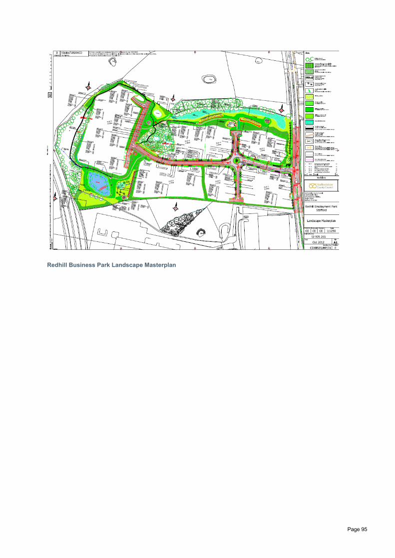
Redhill Business Park Landscape Masterplan
Page 95

Appendix E1 Staffordshire County Council Surface Water Drainage Statement Proforma
Page 96
https://www.staffordshire.gov.uk/environment/Flood-Risk-Management/Proforma-For-Small-Residential-Major-Development.pdf

For more information please contact:Flood Risk PlanningStaffordshire County CouncilNo.2 Staffordshire PlaceTipping StreetStafford ST16 2DHE-mail: [email protected]