surveys, parcels and tenure on canada lands, brian ballantyne
TRANSCRIPT

Edited by Dr. Brian Ballantyne
SurveyS, ParcelS and Tenure on canada landS
© Her Majesty the Queen in Right of Canada, 2010
Natural Resources Canada Surveyor General Branch 605, 9700 Jasper Avenue Edmonton, Alberta T5J 4C3
TTY: 613-996-4397 (Teletype for the hearing-impaired)
Library and Archives Canada Cataloguing in Publication
Surveys, parcels and tenure on Canada Lands [electronic resource] / edited by Brian Ballantyne.
Electronic monograph in PDF format.
Issued also in French under title: Arpentages, parcelles et tenure sur les terres du Canada.
Issued also in printed form.
Includes bibliographical references.
ISBN 978-1-100-17563-8 Cat. No.: M4-97/2011E-PDF
1. Surveying--Canada.
2. Surveying--Law and legislation--Canada.
3. Land tenure--Canada.
4. Land tenure--Law and legislation--Canada.
5. Canada. Surveyor General Branch.
6. Public lands--Canada.
7. Crown lands--Canada.
I. Ballantyne, Brian Andrew, 1959-
II. Canada. Surveyor General Branch
HD318 S82 2010 526.9 C2011-980001-2
SurveyS, ParcelS and Tenure on canada landSEdited by Dr. Brian Ballantyne
Illustrator: SteveRogersCLS,MScAuthors: GordOlssonCLS,ALS(retired) SteveRogersCLS,MSc Dr.BrianBallantyne
SurveyorGeneralBranchNaturalResourcesCanada October2010
S u r v e y S , P a r c e l S a n d T e n u r e o n c a n a d a l a n d S
ii
Informationcontainedinthispublicationorproductmaybereproduced,inpartorinwhole,andbyanymeans,forpersonalorpublicnon-commercialpurposes,withoutchargeorfurtherpermission,unlessotherwisespecified.
Youareaskedto:
◆ exerciseduediligenceinensuringtheaccuracyofthematerialsreproduced;
◆ indicatethecompletetitleofthematerialsreproduced,andthenameoftheauthororganization;and
◆ indicatethatthereproductionisacopyofanofficialworkthatispublishedbytheGovernmentofCanadaandthatthereproductionhasnotbeenproducedinaffiliationwith,orwiththeendorsementof,theGovernmentofCanada.
CommercialreproductionanddistributionisprohibitedexceptwithwrittenpermissionfromtheGovernmentofCanada’scopyrightadministrator,PublicWorksandGovernmentServicesCanada(PWGSC).Formoreinformation,contactPWGSCat613–996–[email protected].
DISCLAIMER
HerMajestyisnotresponsiblefortheaccuracyorcompletenessoftheinformationcontainedinthereproducedmaterial.HerMajestyshallatalltimesbeindemnifiedandheldharmlessagainstanyandallclaimswhatsoeverarisingoutofnegligenceorotherfaultintheuseoftheinformationcontainedinthispublicationorproduct.

iii
Contents
Foreword. . . . . . . . . . . . . . . . . . . . . . . . . . . . . . . . . . . . . v
Preface . . . . . . . . . . . . . . . . . . . . . . . . . . . . . . . . . . . . . vii
1Context . . . . . . . . . . . . . . . . . . . . . . . . .Brian Ballantyne 1
2HistoryoftheSurveyorGeneralBranch. . .Steve Rogers 11
3FirstNationReserves . . . . . . . . . . . . . . . . Gord Olsson 25
4InitiativesonAboriginallands . . . . . . .Brian Ballantyne 49
5Subsurfacesouthof60 . . . . . . . . . . . . . . .Steve Rogers 61
6NationalParks . . . . . . . . . . . . . . . . . . . . . Gord Olsson 83
7NorthwestTerritories . . . . . . . . . . . . . . . . Gord Olsson 97
8Nunavut . . . . . . . . . . . . . . . . . . . . . . . . .Gord Olsson 121
9Yukon. . . . . . . . . . . . . . . . . . . . . . . . . . .Gord Olsson 131
10Offshore. . . . . . . . . . . . . . . . . . . . . . . . .Steve Rogers 147

S u r v e y S , P a r c e l S a n d T e n u r e o n c a n a d a l a n d S
iv
v
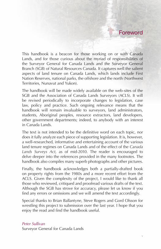
Foreword
This handbook is a beacon for those working on or with CanadaLands, and for those curious about themyriad of responsibilities ofthe Surveyor General for Canada Lands and the Surveyor GeneralBranch(SGB)ofNaturalResourcesCanada.Itcaptureswellthesalientaspects of land tenure onCanada Lands,which lands include FirstNationReserves,nationalparks,theoffshoreandthenorth(NorthwestTerritories,NunavutandYukon).
Thehandbookwillbemadewidelyavailableontheweb-sitesoftheSGBand theAssociationofCanada Lands Surveyors (ACLS). Itwillbe revised periodically to incorporate changes to legislation, caselaw, policy and practice. Such ongoing relevance means that thehandbook will remain invaluable to surveyors, land administrators,students, Aboriginal peoples, resource extractors, land developers,othergovernmentdepartments; indeed, toanybodywithan interestinCanadaLands.
Thetextisnotintendedtobethedefinitivewordoneachtopic,nordoesitfullyanalyzeeachpieceofsupportinglegislation.Itis,however,awell-researched,informativeandentertainingaccountofthevariouslandtenureregimesonCanadaLandsandoftheeffectoftheCanada Lands Surveys Act, as of mid-2010. The reader is encouraged todelvedeeperintothereferencesprovidedinthemanyfootnotes.Thehandbookalsocompilesmanysuperbphotographsandotherpictures.
Finally, the handbook acknowledges both a partially-drafted bookonpropertyrightsfromthe1980sandamorerecenteffortfromtheACLS.Giventhecomplexityof theproject, Iwouldliketothankallthosewhoreviewed,critiquedandproofreadvariousdraftsofthetext.AlthoughtheSGBhasstroveforaccuracy,pleaseletusknowifyoufindanyerrorsoromissionsandwewillamendthetextaccordingly.
SpecialthankstoBrianBallantyne,SteveRogersandGordOlssonforwrestlingthisprojecttosubmissionoverthelastyear.Ihopethatyouenjoythereadandfindthehandbookuseful.
Peter SullivanSurveyorGeneralforCanadaLands

S u r v e y S , P a r c e l S a n d T e n u r e o n c a n a d a l a n d S
vi
vii
Preface
“Thereispropertyatstake;itisnotamatterforaffection,”exclaimedLord Caversham while selecting a suitable spouse for his son, inAn Ideal Husband,Wilde’s take onmarriage,morality and artificialwatercourses.ThishandbookrefutesLordCaversham,forit isaboutpropertyanditisinfusedwithaffection.Rather,itisabouttheparcelfabricthatallowslandtobecomepropertyanditswritingwasdrivenbyaffection;affectionforthesubjectmatterandaffectionforthefinishedproduct.Or,ifnotdrivenbyaffectionthenbymoney,forwewereallpaidhandsomely.Despitemytwocolleagues-SteveandGord-beingseducedbythepowerandglorythataccretestoallsuccessfulwriters,itwas, indeed a pleasure toworkwith them. They each brought adistinctive styleandworkethic to theexercise.Suchdistinctivenessalsocharacterizedtheeffortsofthepublishinggang.
However,ourcollectiveeffortsoverthesemanymonths,sustainedbyaverysupportivepatron,some730footnotesandquestionabledimsumwill have been for naught if the handbook is not read. Admittedly,DostoevskyandJoycemighthavebeenunperturbedthatfewpeoplereadCrime and PunishmentandUlysses.I,however,shallbeperturbedifthishandbookisnotreadbythehordesofCanadianswhohavelongprofessedakeen interest inCanadaLands.To thatend, ithasbeenwrittensoastoberead,ifyouhavethegumption.
And to that end, I strongly recommend that you stop ditheringaroundintheprefaceandmoveontootherpartsof thehandbook.Chapters1and4areparticularlystellar,butitwouldbechurlishofmenot tomentionthecharmsof theothereightchapters.Asyouread,thinkaboutthepurposeofthehandbook–toassistinthemightyandongoing enterprise of surveying a few acres of snow, to paraphraseVoltaire’s1759descriptionofCanada.
Dr. Brian BallantyneEditor
S u r v e y S , P a r c e l S a n d T e n u r e o n c a n a d a l a n d S
viii
1
1Context
What is the purpose of the handbook?
Thishandbookhastwobroadobjectives.First,itdescribesthevarioustypesofCanadaLands,andsetsouthowboundariesandparcelsarecreatedandadministeredonCanadaLands.ThisdescriptionshouldbeofusetolandsurveyorsacrossCanada(notnecessarilylimitedtoCanadaLandsSurveyors);toFirstNationsandotherAboriginalpeopleswholiveonReservesorintheNorth;tothosewhohavepropertyrights(possessionoruse)onCanadaLands;tothegovernmentdepartmentswhoadminister thoserights; to thosewithaninterest in landtenureonCanada Lands; and to candidates before theCanadianBoard ofExaminersforProfessionalSurveyors(CBEPS).
ThesecondbroadobjectiveistoinformadiverseaudienceabouttherolesoftheSurveyorGeneral(SG)andtheSurveyorGeneralBranch(SGB)ofNaturalResourcesCanada(NRCan).Thisaudienceincludesvarious levels within NRCan; other government departments withwhom SGB works closely (such as Indian Affairs, Parks, Fisheries& Oceans, Public Works and Justice); Chiefs, Councils and LandsManagers within First Nations and Inuit communities; and landsurveyorsandadministratorswithinotherlevelsofgovernment(suchastheprovincesandtheterritories).
Ofcourse,thehandbookmusttellagoodstory,forallstylesaregood,excepttheboring.1Tothatend,itissprinkledwithcolourfulvignettes,winsome quotations and cutting-edge analyses, and it answers the
1 Voltaire.L’Enfant Prodigue.Preface.1736:“Touslesgenressontbonhorslegenreennuyeux.”

2
S u r v e y S , P a r c e l S a n d T e n u r e o n c a n a d a l a n d S
pressing questions, such as: How did the first post-ConfederationSurveyorGeneralbehaveduringtheFenianraids?2
What is the purpose of this chapter?
Thischaptersetsthecontextfortherestofthehandbookbydefiningsome termsandconcepts, suchasCanadaLands, cadastral surveysandCanadaLandsSurveyor;boundaries,parcelsandlandtenureonCanadaLands;andthemandateoftheSGB.Thechapteralsosetsthestage for the substantivechapters that follow,whichelaborateuponboundaries,parcels,surveysandtenureoneachofthevarioustypesofCanadaLands.
What is the relationship between the Minister of Natural Resources and the Surveyor General?
TheMinister of Natural Resources has the administration, directionandcontrolofsurveysundertheCanada Lands Surveys Act (CLSAct).TherearesevenothersectionsoftheCLSActthatspeaktotheroleoftheMinister;alldealwiththecircumstancesinwhichCanadaLandsoranyfederalCrownlandsshallbesurveyedandthemethodsofsuchsurveys.
However, much discretion is afforded the Surveyor General (SG).SubjecttothedirectionoftheMinister,theSurveyorGeneralhastwoverybroadresponsibilities:
◆ themanagementofsurveysundertheCLSAct;and◆ thecustodyofalltheoriginalplans,journals,fieldnotesandotherpapersconnectedwiththosesurveys.3
Inaddition, theSGhasresponsibilitiesunderlandclaimagreementsbetweenAboriginalpeoplesandCanada.Forexample, theNunavutAgreementsetsout thatsurveysof InuitOwnedLandsshallonlybeconductedinaccordancewiththeinstructionsoftheSGandtheCLSAct.4Similarly, theTlichoAgreementsetsout that theboundariesofTlicholandsshallbesurveyedinaccordancewiththeinstructionsoftheSGandtheCLSAct.5
2 Seechapter2forthefullstory.3 Canada Lands Surveys Act,s.3.4 Agreement between the Inuit of the Nunavut Settlement Area and Her Majesty the Queen in right of Canada.
s.19.8.11.1993.5 Land Claims and Self-Government Agreement among the Tlicho and the Government of the Northwest
Territories and the Government of Canada.s.18.4.1.2003.
3
Context 1
What is the mandate of the Surveyor General Branch?
TheSurveyorGeneralBranch (SGB)mandate is themaintenanceofparcelfabriconCanadaLands–themanagementofsurveys.Indeed,surveysofCanadaLandsshallonlybemadeinaccordancewiththeinstructionsoftheSG.6SGBfocusesonsettingstandards,developingpolicies, issuing instructions for and examining plans of survey,recordingplansinandprovidinginformationfromtheCanadaLandsSurveysRecords(CLSR),profferingboundaryopinions,advisingothergovernment departments, liaising with First Nations and managingcontracts(some$7millionperyear).Eachyear:
◆ 13,500monumentsareestablished;◆ 2,000documentsareregisteredintheCLSR;◆ 5,000kmofboundariesaresurveyed.
What are Canada Lands?
CanadaLandsaredefinedintheCanada Lands Surveys Act(CLSAct).In the terrestrial environment, they are any lands belonging to thefederalCrown (Canada) or ofwhichCanada has power to dispose,thataresituatedinYukon,theNorthwestTerritories,NunavutorinanyNationalParkandanylandsthatare
(i) surrenderedlandsorareserve,asdefinedinthe Indian Act,
(ii) CategoryIAlandorCategoryIA-Nland,asdefinedintheCree-Naskapi (of Quebec) Act,chapter18oftheStatutesofCanada,1984,
(iii) Secheltlands,asdefinedintheSechelt Indian Band Self-Government Act, chapter27of the StatutesofCanada,1986,
(iv) settlement land, as defined in the Yukon First Nations Self-Government Act, and lands inwhich an interest istransferredorrecognizedundersection21ofthatAct,
(v) lands in the KanesatakeMohawk interim land base, asdefinedintheKanesatake Interim Land Base Governance Act, other than the lands known asDoncaster ReserveNo.17,or
(vi) Tlicho lands, as defined in section 2 of theMackenzie Valley Resource Management Act.
6 Canada Lands Surveys Act,s.24(2).
4
S u r v e y S , P a r c e l S a n d T e n u r e o n c a n a d a l a n d S
Intheaquaticenvironment,CanadaLandsareanylandsunderwaterbelongingtothefederalCrown(Canada)orinrespectofanyrightsinwhichCanadahaspowertodispose.7
How do lands become Canada Lands?
Canada Lands are merely a subset of federal Crown lands, whichincludes all land held by the federal Crown for whatever purpose(defence, airports, post offices)8 So,Canada Lands come into beingeither:
◆ by the federal Crown designating federal real property asCanadaLands(suchasaNationalPark,FirstNationReserve);
◆ by the federal Crown first acquiring lands as federal realpropertywhicharethendesignatedasCanadaLands.
Lands are acquired through purchase (from awilling seller), by thetransfer of administration and control from a provincial Crown tothe federal Crown, or by expropriation (from an unwilling seller).Administration and control of land is passed between governments(as from provincial to federal Crown). Within the federal Crown,only administration is passed between ministers. There are variousmechanisms used, including Orders in Council, Ministerial Orders,agreements,legislationandcourtorders.Foranexampleofthelatter,theOntarioSuperiorCourtofJusticerecentlygrantedtovariousislandsinLakeoftheWoodsthesamestatusasthatofallthelandsofKenoraIndianReserve38B.9
What is cadastral surveying?
In a nutshell, surveying determines the shape of the earth or theposition of boundaries, points and things in relation to the surfaceof the earth (either on the surface, below the surface or above thesurface).Ofcourse,surveyingalsoinvolvesgettingandusing“spatiallyrelated informationpertaining to theearth.”Cadastral surveying isasubsetofsurveyingthatfocusesnotontheshapeoftheearthbutonboundaries,soasto:
◆ identify, establish, document or describe a boundary, oranythinginrelationtoaboundary;and
◆ generate,manipulate,adjust,store,retrieveordisplayspatialinformationthatdefinesaboundary.10
7 Canada Lands Surveys Act,s.24.8 Federal Real Property and Federal Immovables Act.9 Kakeway (Rat Portage Indian Band) v. The Queen (Canada and Ontario),April13,2005.(OntSCJ).10 Canada Lands Surveyors Act,s.1.

5
Context 1
Cadastralsurveysaremerelyameanstoanend;theyarenotanendin themselves. A preliminary end is to establish boundaries on theground.Asecondaryend is toestablishparcelson theground.Theultimateendistoallowfortheefficient,productiveandeconomically-viableuseofland.
Who can survey boundaries on Canada Lands?
Ingeneral,onlyaCanadaLandsSurveyor(CLS)shallsurveyboundariesonCanadaLands.ThiscertainlyappliesinNWT,Nunavut,Yukonandthe offshore. However, a CLS or any other surveyor authorized bytheSGmaysurveyCanadaLandsthatliewithintheboundariesofaprovince.IfsuchsurveysarelikelytoaffecttherightsoflandownersofadjoiningparcelsthatarenotCanadaLands,thenthesurveysshallbemadebyasurveyorofthatprovince.11
What is a boundary?
Aboundary is anatural featureorartificial linewhich indicates thespatial extent of the legal interest in land.12Aparcel is thepolygonoflandtowhichlegalrightsapply;landisdefinedbroadlytoincludeupland,watercourses,water,airspace,naturalresourcesandstructures.Commonly shownas a two-dimensional area on the surfaceof theearth(depictedonsurveyplansashavingonlywidthandlength,butnoheight/depth)manyparcelsarevolumesconsistingofsub-surfaceand air rights. Think of the carrot (or sno-cone) as metaphor, withthevolumeof theparcelconverging in thedepthsof theearthanddivergingintheheightsofthesky.
Theboundaryisthetwo-dimensionalplaneattheedgeoftheparcel.Aboundaryhaslength(aslongasthesidesoftheparcel)andheight(ashighastherightsextendanddescend)butnowidth.Itmightwellbeaninvisibleplanethatisnotmarkedonthesurfaceoftheearth;itiscertainlynotan“imaginary line.”13Boundariesaredefinedby thepartieswhohaveaninterestintheland.
How common are boundaries?
Boundariesareubiquitous,becauseparcelsareubiquitous;thedesireforboundsisinnateinourspecies.14Peoplevalueathing,suchasaparcelofland-“it’smine,Itellyou”–morewhentheyhavepossession
11 Canada Lands Surveys Act,s.26.12 Canada Lands Surveyors Act,s.1.13 DespitetheunsubstantiatedassertionofBlomley:Makingprivateproperty:Enclosure,commonrightandthe
workofhedges.Rural History.V.18–n.1.p.14.2007.14 Jones&Brosnan.Law,biologyandproperty:Anewtheoryoftheendowmenteffect.William and Mary Law
Review.v.49–n.6.p.1935.2008.
6
S u r v e y S , P a r c e l S a n d T e n u r e o n c a n a d a l a n d S
thanwhentheydon’thavepossession.15Thelimitsofsuchpossessionarerepresentedbyboundaries.Allpeoplesacrossallcultures(diverseintimeandspace)marktheboundariesoftheirparcelsontheground.Crakers–agroupofgeneticallymodifiedhumanswhoeatgrass,haveagreenishhueandare rathernaive–dailydemarcate theextentoftheirterritorybyurinatingalongtheboundary.16
Boundariesserveeconomic,socialandsecuritypurposes,dependingon the typeofparcel.Boundariesbetweencountries (states)help tosecureproperty rights, signalmuchgreater jurisdictional andpolicycertainty and thereby reduce costs associated with internationaleconomictransactions.17Withinstates,parcelstendtobecontrolledbyindividuals,familiesorgroups.Forthelatter,acommon-poolresource(suchaspasture)canonlybewellallocatedifclearboundariesdefinetheappropriatedresource.18Thisisnottosaythattheboundariesoftheparcelarenecessarilyfixedinplaceacrosstime,becausecommunityaccesstosharedresourcesoftenrequires“fuzziersocialorgeographicboundaries.”Fluidspatialboundariesallowparcelstoadjusttoresourcemobility(suchasmigratoryspecies)andseasonalavailability.19
When do boundaries assume more significance?
Boundaries assume more prominence when there are competingdemandsforscarceresourceswithinacountryorregion.Boundariescanbeexplainedasafunctionofpropertyrights,whenthegainsofdefining, demarcating and maintaining boundaries become largerthan thecostofdoingso.20Conversely,access is less restrictedandexclusionandgovernancecostsarehigherwhenrightsandparcelsareill-defined.21TheenclosuremovementinEnglandintheearly1800s,for example,meant that the benefits of enclosing themoors (moreproductiveuse)exceededthecostsofenclosure(bounding, fencing,drainingandpolicing).22TheadventofthefurtradeineasternCanadameant that both the value of furs and the scale of hunting activityincreased.Thereweremorepeoplehuntingmoreintensivelyformore
15 The Economist.p.95.June21,2008.16 Atwood.Oryx and Crake.2003.Ofcourse,Crakersarealsowaryofpigoonsandracunks(hybridpig/raccoon
andraccoon/skunkanimals,respectively)andfornicatebutonceeverythreeyears.17 Simmons.Rulesoverrealestate:Trade,territorialconflictandinternationalbordersasinstitution.Journal of
Conflict Resolution.v.49–n.6.pp.823–848.December2005.18 Ingram&Hong(eds).Propertyrightsandlandpolicies.Proceedings of the 2008 Land Conference.Lincoln
InstituteofLandPolicy.2009.19 Cox,etal.Designprinciplesarenotblueprints,butaretheyrobust?Ameta-analysisof112studies.Working
Paper – Lincoln Institute of Land Policy.p.6.2009.20 Demsetz.Towardsatheoryofpropertyrights.The American Economic Review.v.57–n.2.p.352.May1967.21 Anderson&Swimmer.Someempiricalevidenceofpropertyrightsoffirstpeoples.Journal of Economic
Behaviour and Organization.v.33–n.1.p.13.May1997.22 Eastwood.Communities,protestandpoliceinearly19thcenturyOxfordshire:TheenclosureofOtmmor
reconsidered.The Agricultural History Review.v.44–n.1.pp.35–45.1995.
7
Context 1
fur-bearing animals within the same traditional territory. Aboriginalpeoples were therefore forced to constrain each band’s hunting toparcelsof foursquareleagues,anareaofsome32squarekm.Suchparcelshadtheirboundariesmonumented–treesontheboundarieswereblazed.23
What of boundaries as topography?
Aprecise territorialboundarymustbepermanentandeasily seen.24ThefirstparcelsinCanadausednaturalfeatures,suchaswatersheds,watercourses,andlinesbetweentopographicfeatures.Theywerethemostsuitableboundariesbyvirtueofbeingvisible,physicalbarriers.However,increasingpopulationandburgeoningtechnologymeantthatthese“insufficientlyprecise”25topographicboundariesledtodisputes:
Simon:“Itooktheshortcutoverthecliffsandfollowedoneoftheoldsmugglers’pathsthroughthetreacherousswampsthatsurroundthisstrangelyinaccessiblehouse.”
Mrs. Drudge: “Yes, many visitors have remarked on thetopographical quirk in the local stratawhereby there arenoroadsleadingfromthemanor,thoughtherearewaysofgettingtoit,weatherallowing.”26
A case in point is the current boundary between the provinces ofAlbertaandBritishColumbia.WhenthelatterenteredCanadain1871itseasterlyboundarywasthewatershedoftheRockyMountains.Bytheearly20thcentury the locationof thewatershedwasdifficult tolocatethroughmanyofthepasses,andsosurveyorsreplacedsectionsof the imprecise watershed with a series of straight lines betweenmonuments.Thesenewmonumentsweresanctionedastheboundarythroughlegislation.27
What is the link between parcels, tenure and economic development?
Parcelsareanecessary,albeitnotasufficientconditionforeconomicdevelopment.Landtenuremustalsoallowforefficientpropertyrights,whichanswerfourquestions:
◆ Whohastheright(person,family,corporation)?
23 Leacock.QuotedbyDemsetz.p.352.1967.24 Sjasstad&Bromley.Theprejudicesofpropertyrights.Development Policy Review.v.18.p.18.2000.25 Poole.TheboundariesofCanada.Canadian Bar Review.v.42.p.139.1964.26 Stoppard.The Real Inspector Hound.1968.27 Report of the Commission Appointed to Delimit the Boundary between the Provinces of Alberta and British
Columbia. Part I – From 1913 to 1916.OfficeoftheSurveyorGeneral,Ottawa.1917.
8
S u r v e y S , P a r c e l S a n d T e n u r e o n c a n a d a l a n d S
◆ Whattypeofrightexists(certificatesofpossession,long-termleases,short-termleases,licences,customaryuses,feesimple,Aboriginaltitle)?
◆ Howmuchistherightworth?Whatisitsvalue?(cashisoftenused as a proxy for value, but land, of course has culturalvalueaswell);
◆ Whereistheright?THISistheroleoftheparcel–tolocatetheright,andtodefinethespatialextentoftherightthroughboundaries.
However, that is only half the equation.Defining property rights isimportant,butmanagingsuchrightsisequallyimportant.Thisincludestransferringtherights;mortgagingtherights;subdividingtherights;andlanduseplanning.Landuseplanning,bydefinition,requiresparcels.Forexample:
◆ separationbetweendwellingsforfireprotection;◆ turningradiiforemergencyvehicles;◆ massing(densityofconstruction)forinfrastructureaccessandaesthetics;
◆ zoning, so as to reduce negative externalities from theapocryphalglue-factory;
◆ geo-technical considerations -not creatingparcelsonareaspronetoerosion,landslides,subsidenceorearthquakes;
◆ environmentalconsiderations–parcelsalongwatercoursestoprotectfishhabitat.
Does the SG have much discretion as to how Canada Lands are surveyed?
Yes, Canada Lands may be surveyed, laid out and defined in anymanner,byanymethodofsurveyingandwithanydescriptionthattheMinisterofNaturalResourcesconsidersdesirableinthecircumstancesaffectingthoselands.28SGB’sdiscretionextendstothreegoals.ThefirstisensuringthatthesurveyfabriconCanadaLandsmeetsorexceedsabutting provincial standards. The second is integrating the parcelfabricwithlanduseplanningandlandregistries.Thethirdisbuildingcapacity within First Nations to deal with thorny boundary issues,sensitivetothebiophysical,economicandculturalenvironment:
� in theQu’AppelleValleySGB isassistingFirstNationsbyusingimagerytore-establishwaterboundaries;
28 Canada Lands Surveys Act,s.27.

9
Context 1
� in Nunavut, SGB uses a combination of natural features(such as watercourses) and monuments to survey some1,100landclaimparcels.
TheGeneralInstructionsforSurvey(e-Edition)includesadministrativerequirements and survey standards for surveys. These generalrequirementsareoftenaugmentedbyspecificsurveyinstructionsforeachparcelorproject.29TheymaybeobtainedfromtheSGBClientLiaisonOfficeservingtheregioninwhichthelandsaretobesurveyed.
What of commercial efficacy?
SGBregulatestwotypesofsurveys–directandindirect.Directsurveysarepaid forandcontractedby theCrown (as for re-establishing theexternalboundariesofaReserve).Therequestforsurveyinstructionsgenerallycomesfromtheadministeringgovernmentdepartment,suchas Indian andNorthernAffairs Canada (INAC). Indirect surveys arepaidforbyapartyotherthantheCrown(asbyaFirstNationwantingto establish internal parcels on a Reserve). Survey instructions aregenerallysoughtbytheCLSretainedbythatparty.
What of federal Crown lands that are not Canada Lands?
Section47of theCLSActallowsasurvey tobemadeofany landsbelonging to the federal Crown (Canada) or of which Canada haspower to dispose. However, this section is only applicable whenfederalCrownland(registeredinaprovinciallandregistry)istobecomeCanadaLandsortobemanagedasCanadaLands.InthesecasestherewillbeanagreementbetweentheadministratingdepartmentandSGB.
IneasternCanada,thissectionisusedregularly.30InwesternCanadatherewereonlythreesuchsurveysbetween2001and2009,because:
◆ theprovincialregistrymightrejectaCLSsurveyoftheparcel;◆ itisnotmeanttocircumventmunicipalregulationspertaining,for instance, to subdivision, because “Federal Crown landsdo not constitute extra-territorial enclaves within provincialboundaries.”31
Onesuchsurveywasofaparcelof foreshore inEsquimaltHarbour(federalCrownland),soastotransfertheparceltotheNewSongheesFirstNation(CanadaLands)asanadditiontotheReserve.
29 Seechapters7and8forsurveysthatdonotrequirespecificinstructions.30 FortheperiodJan1,2008toMarch1,2010,28planswererecordedundersection47fortheRideauCanal,
and14plansfortheTrent–Severnwaterway31 Construction Montcalm Inc v. Quebec,[1979]1SCR754,at778(SCC)

10
S u r v e y S , P a r c e l S a n d T e n u r e o n c a n a d a l a n d S
What of the SG’s responsibility on non-Canada Lands?
PartsoftheCLSActapplytosurveysunderanyotherActofParliament,orunderanyterritorial legislation(NWT,Nunavut,Yukon) if theActor legislation requires the surveys to be made by a Canada LandsSurveyor.32Thismeansthat,asrequiredbytheSG,theCLSmustverifyallplansofsurveyandfilefieldnotesintheCLSRforfeesimplelandintheNorththatarenotCanadaLands.33Asanotherexample,federallegislationpertainingtoDominionwater-powersrequiresthattheSGissuesurveyinstructions.34
What of plans of survey?
TheSGBhastwobroadcategoriesofplans.Section31allowstheSGtomakeplansofpubliclandsforadministrativepurposes.Suchplansaresometimessurveyedontheground,andaresometimescompiledintheofficefromothersources.
Section29allowsforfullysurveyed,monumented,confirmedplansofCanadaLands.TheeffectoftheSGconfirmingaplanismanifold,andincludes sanctioning the surveyed lines to be the “true”boundariesoftheparcels,35evenifdifferentfromthoseshownontheplan.Thisisthefundamentalprincipleofboundarysurveys:“Neitherthewordsof a deednor the lines andfigures of a plan, can absolutely speakfor themselves. They must in someway or other be applied to theground.”36
32 Canada Lands Surveys Act,s.22.33 Seechapters7–9(onNWT,NunavutandYukon)forthefullstory.34 Dominion Water Power Act - Regulations,s10.35 Canada Lands Surveys Act,s.32.36 Equitable Building & Investment Co. v. Ross(1886),5NZLR229(SC);South Australia v. Victoria,[1914]AC
283(PC);Okanagan Radio v. Dunlop,1996BCSC2954(CanLII).

11
2History of the Surveyor General Branch
Whence comes the title of Surveyor General?
ThetitleofSurveyorGeneralhasarichhistory.Apreservedwrithasbeen found from King James V appointing Sir James Nycholay tothe post of SurveyorGeneral ofWork to theCrownof Scotland in1529.37ThispostinScotlandappearstohavebeensynonymouswiththe SurveyorGeneral of the King’sWorks (or essentially, the King’sArchitect)inEngland.ThetwoweremergeduponabsorptionintotheOfficeofWorksinGreatBritain1768.InEngland,earlyrecordsindicatethepostofSurveyorGeneralbeingoccupiedasearlyas1597,38andincludenotablessuchasSirChristopherWrentoitsranks.39
Earlyholdersofthetitlewereoftentheprivilegedwhoattendedthecourtofthemonarch.SirJamesHamiltonofFinnart(SurveyorGeneralofScotland in1539), forexample,was thesecondcousinandclosechildhoodfriendofKingJamesVofScotland.GivenHamilton’shastyexecution for treason in1540,however, they appear tohavehad afallingout.40SirDavidCunninghameofRobertlandwasconsideredacollaboratorinthemurderoftheEarlofEnglintounin1585,41exiledtoDenmark,rehabilitated,knightedbyKingJames,andmadeSurveyor
37 Mylne.TheMastersofWorktotheCrownofScotland,from1529to1768.Proceedings of the Society of Antiquaries of Scotland. 1896
38 Colvin.A biographical dictionary of British Architects, 1600–1840. Yale.200839 Wrenwaswellknownforhisoutstandingarchitecturework,butisperhapsbestrememberedforhisinnocent
wagerwithtwootherscientificluminariesofthetime,RobertHookeandEdmundHalley,onthemovementsofcelestialobjects.Stumpedbytheovalmovementoftheseobjects,theyturnedtoalittleknownprofessoratCambridge,IsaacNewton,whointurnpublishedoneofthemostreveredpiecesofscientificlore,Principia.Bryson.Short History of Nearly Everything. Broadway.2004
40 McKean.Hamilton,SirJames,ofFinnart(1495–1540).Oxford Dictionary of National Biography. 200441 Robertson.A genealogical account of the principal families in Ayrshire. CunninghamePress. 1823

12
S u r v e y S , P a r c e l S a n d T e n u r e o n c a n a d a l a n d S
General in 1604.42 Sir JohnDenham, the poet, served as SurveyorGeneral fornineyears (1660–1669)despitehaving littleaptitude forarchitecture.43 Interspersed among these political appointments,however,we see some truly gifted architects. Inigo Jones served asSurveyorGeneralfornearlythreedecades(1615–1643),andiscreditedwith bringing Italian renaissance designs to England.44 Wren spentnearlyhisentireadultlifeasSurveyorGeneral(1669–1718)designingsome of themost notable buildings in England, including St. Paul’sCathedralin1710.45
InCanada,theSurveyorGeneraldidlittleoverseeingordesigningofarchitecturalwonders,andmuchmeasuringandsettlingofland.Theshift represents an adaptation to a changing environment.Having apositionforrepairsto“royalpalaces…andpreparationofnoblemen’shouses”46 was superfluous here. The shift also represents a moreglobaladaptationinthesurveyingprofession.InEngland,priortothelatesixteenthcentury,theroleofthesurveyorwasthatofan“estatesteward” or “overseer” and he was “expected to examine recordsof tenure and receive tenants for their performanceof homage andfealty”.47Withincreasingdemandforavailableland(causeditselfbyincreasingpopulations),thereleaseoflargetractsoflandfromchurchownership, and great advances in optical technology,48 surveyors’roleschangedtobeingtechnicalexperts.Theirfocuswasaccuratelymeasuringpropertylines49toalleviate“discontentedtenantfarmer”50complaints.
This environmental determinism and professional change is bestillustrated by some of the earliest Surveyors General in the newworld.ThomasHolme,thefirstSurveyorGeneralofPennsylvaniain1682,51hadtheprimaryfunctionoflayingoutthecityofPhiladelphia,surveyingtownshipsandmanors,andproducingthefirstaccuratemapsofsettlementandtopography.52WilliamClaiborne,SurveyorgeneralofVirginiain1621,hadthetaskof“prescribingofbounds…toprevent
42 McKean.The Scottish Chateau. Sutton.200143 Kelliher.Denham,SirJohn(c.1614–1669).Oxford Dictionary of National Biography. 200844 Anderson.Inigo Jones and the Classical Tradition. Cambridge. 200745 Jardine.On a grander scale: The outstanding career of Sir Christopher Wren.HarperCollins. 200346 Milne.The age of Inigo Jones. Batsford.195347 McRae.Toknowone’sown:EstatesurveyingandtherepresentationofthelandinearlymodernEngland.The
Huntington Library Quarterly. Pg.336. 199348 McRae.pg.33949 Blomley.Law,property,andthegeographyofviolence:thefrontier,thesurvey,andthegrid.Annals of the
Association of American Geographers. 93(1),pp.121–141. 200350 McRae.pg.34151 WilliamPennactuallyappointedhiscousinWilliamCrispinfirst,butheperishedonthetripfromEngland.
Munger.Pennsylvania Land Records. RowmanandLittlefield.199352 Corcoran.Thomas Holme, 1624–1695. DianePublishing.1992

13
History of the Surveyor General Branch 2
futureuncertaintiesanddisputes” toavast arrayofplantations.53 InCanadathepositionhasneverbeenthatofanarchitect,buthaslongconcentratedonthesurveyandsettlementofCrownland.
Who were the early Surveyors General in Canada?
The first individual to hold the title inwhat is present day CanadawasCharlesMorris,whowasappointed to thepositionofSurveyorGeneralofNovaScotia in1749.Hisappointmentwaslargelybasedonthestrengthofhis1748surveyofAcadiancommunities.54Heheldtheposition forover threedecades,andwassucceededbyhis son,grandson,andgreatgrandson.Thus,theMorrisfamilyheldamonopolyonthetitleinNovaScotiaforoveracentury.55
Morris’ influence is visible even today. After Edward CornwallisfoundedHalifaxin1749,Morriswasoneofitsfirstsettlers,andhelpedlayoutthelotsandroads.HehelpedfoundthetownofLunenburgbyaidingintheselectionofthesite,andlayingoutthelotstructure.HehadasimilarroleintheestablishmentofwhatarepresentdayTruro,Windsor, Liverpool, and Yarmouth.56 Despite these achievements,Morris is also remembered for his strong advocacy of the removalof theAcadians.Hebelieved theBritish settlementof the areawasimpossible with the Acadian presence and even went so far as tosuggest that themost effective removalmethodwas to “destroy allthesesettlementsbyburningdownallthehouses,cuttingthedykes,anddestroyalltheGrainnowgrowing”.57
To the west, Samuel Holland was appointed Surveyor General ofQuebecin1763,butofferedtoassumethelargerpositionofSurveyorGeneraloftheNorthernDistrictofNorthAmericaatnoincreaseinsalary (anoffer theauthorities,not surprisingly, accepted).58HewasinstructedtosurveyallcrownpossessionsnorthofthePotomacRiver(presentdayMaryland/Washington,D.C.) tofacilitatesettlement.Hestarted at St. John’s Island (Prince Edward Island),59 the MagdaleneIslands,andCapeBretonIslandbecauseoftheeconomicimportanceoftheseareasduetothrivingfisheries.HollandsubdividedSt.John’sIslandinahighlyaccuratemannerusingnewinstruments(astronomical
53 Hatch.The first seventeen years, Virginia, 1607–1624. UniversityofVirginia.195754 Faragher.A great and noble scheme. W.W.Norton. 200555 Blakeley.Morris, Charles. Dictionary of Canadian Biography. 200056 Morris.DescriptionandstateofthenewsettlementsinNovaScotiain1761. Report Concerning Canadian
Archives for the year 176157 Morris.RemarksconcerningtheremovaloftheAcadians. Nova Scotia Historical society. 175358 Thorpe.Holland,SamuelJohannes.Dictionary of Canadian Biography. 200059 St.John’sIslandwascededtotheBritishbytheTreaty of Paris (1763)
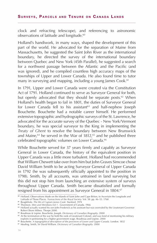
14
S u r v e y S , P a r c e l S a n d T e n u r e o n c a n a d a l a n d S
clock and refracting telescope), and referencing to astronomicobservationsoflatitudeandlongitude.60
Holland’shandiwork,inmanyways,shapedthedevelopmentofthispart of the world. He advocated for the separation of Maine fromMassachusetts,hesuggestedtheSaintJohnRiverastheinternationalboundary, he directed the survey of the international boundarybetweenQuebecandNewYork(45thParallel),hesuggestedasearchfor a northwest passage between the Atlantic and the Pacific (andwasignored),andhecompiledcountlesshighaccuracymapsofthetownshipsofUpperandLowerCanada.Healsofoundtimetotutormanyinsurveyingandmapping,includingayoungJamesCook.61
In1791,UpperandLowerCanadawerecreatedviatheConstitutionActof1791.HollandcontinuedtoserveasSurveyorGeneralforboth,but openly advocated that they should be separate posts.62 WhenHolland’shealthbegantofailin1801,thedutiesofSurveyorGeneralfor Lower Canada fell to his assistant63 and half-nephew JosephBouchette. Bouchette had a notable career himself. He performedextensivetopographicandhydrographicsurveysoftheSt.Lawrence,headvocatedfortheaccuratesurveyoftheQuebec-NewYork/Vermontboundary,hewas special surveyor to theKing in implementing theTreaty of Ghent to resolve the boundary between New BrunswickandMaine,64heservedintheWarof1812,65andhepublishedthreecelebratedtopographicvolumesonLowerCanada.66
WhileBouchetteservedfor37yearsfirmlyandcapablyasSurveyorGeneral in Lower Canada, the history of the equivalent position inUpperCanadawasalittlemoreturbulent.HollandhadrecommendedthatWilliamChewetttakeoverfromhimbutJohnGravesSimcoechoseDavidWilliamSmithtobeactingSurveyorGeneralofUpperCanadain1792 (hewas subsequentlyofficiallyappointed to theposition in1798). Smith, by all accounts, was untrained in land surveying butthisdidnotstophimfromlaunchinganextensivesystemofsurveysthroughout Upper Canada. Smith became dissatisfied and formallyresignedfromhisappointmentasSurveyorGeneralin1804.67
60 Holland.ObservationsMadeontheIslandsofSaintJohnandCapeBriton,toAscertaintheLongitudeandLatitudeofThosePlaces.Transactions of the Royal Society. Vol.58.pp.46–53.1768
61 Beaglehole.The life of Captain James Cook. Stanford.197462 Thomson.Men and Meridians.Vol 1 . GovernmentofCanada.196663 HollandactuallywantedhissonJohnFrederickashisassistantbutwasoverruledbytheLieutenantGovernor
RobertShoreMilnes.Thorpe2000.64 Boudreau&Lepine.Bouchette,Joseph. Dictionary of Canadian Biography. 200065 AttheterminationofthewarheheldtherankofLieutenantColonel,andwasfondofmentioninghismilitary
exploitsinpetitioningforahighergovernmentwage.BoudreauandLepine.200066 Bouchette.A topographical description of the provinces of Lower and Upper Canada. London.183267 Mealing.Smith,SirDavidWilliam.Dictionary of Canadian Biography. 2000
15
History of the Surveyor General Branch 2
Figure1–Sam
uelH
olland
’ssurveyofSt.John’sIsland
(PEI).
Libr
ary
and
Arc
hive
s C
anad
a.NMC23350.1765
16
S u r v e y S , P a r c e l S a n d T e n u r e o n c a n a d a l a n d S
Intheinterim,thepreviouslyoverlookedChewettandThomasRidoutjointlyheld thepositionuntil1805whenCharlesBurtonWyattwasappointed.Wyatt, itbecameimmediatelyobvious,wasnotgoingtoworkout.HeaccusedChewettofperformingpoorwork,firedRidout’sson,complainedaboutwages,andwasaccusedofforginghisnameonaplanwhichhehadnotsurveyed.Hewassuspendedin1807.RidouttookoverasSurveyorGeneralandheldthepositionuntil1829.
Thepositioncycledthroughfourindividualsinthefollowing13years,with corruption becoming rampant within the office. For instance,ChiefClerkJohnRandenhurstbidforCrownlandsforhisfriends(forasmallfee,ofcourse),lostnumeroussurveyrecords,issuedfaultylanddescriptions,andrequestedillegalfeestofixanyresultingproblems.68Asaresult,in1845,theOfficeofSurveyorGeneralwasabolishedbyProvincialstatutefromtheProvinceofCanada.69
Who was the first Surveyor General of Canada?
JohnStoughtonDenniswas appointed thefirst SurveyorGeneralofCanada in 1871.70 Highlighting Dennis’s appointment seems almostanticlimactic given that the orderly survey and settlement of BritishNorthAmericawasalreadyinfullswingundermensuchasMorris,Holland,Bouchette,andamultitudeofindividualsinUpperCanada.As a result of their efforts, a good chunk of Ontario (single-front,double-front,and1000acresystems71)andQuebec(seignioriallots72)werealreadysubjecttofairlyrigidsystemsofsurvey.However,giventheConfederationofCanadaandthepurchaseofRupert’sLandandtheNorthwesternTerritory,theworkofsurveyingwesternCanadawasjustbeginning.
A few weeks prior to Dennis’ appointment, the control andadministration of all Dominion Lands were transferred to theDepartmentoftheSecretaryofStateandtheDominionLandsBranchwasformed.73TheSurveyorGeneral’soffice(withDennisatthehelm)withinthenewBranchwasresponsibleforallsurveys.
Dennishimselfwasabitofanoddity.Outsideofsurveyingcircles,heisoftenafootnoteinhistorytextsasabunglingmilitaryleaderwho
68 Ladell.They left their mark: Surveyors and their role in the settlement of Ontario. Dundurn.199369 Statute8Victoria,c.11,s.1.184570 OrderinCouncil1871–72171 Harris.Canada before Confederation. McGill-Queens.199172 Colebrook.The seigneurial system in Early Canada. UniversityofWisconsin.196673 OrderinCouncil1871–708

17
History of the Surveyor General Branch 2
abandonedhismeninaFenianattack.74Althoughhewasexoneratedbythecourts,oneofthejudgespublishedahighlycriticaldissentingopinion.75 His surveying career was of higher esteem, but he waschastised forhis role in theescalationof theRedRiver rebellionbywhatSirJohnA.Macdonaldcalled“exceedinglyinjudicious”pressure,addingthatDenniswas“averydecentfellowandagoodsurveyor”butquitewithouta“head”.Despitethisratherinauspiciousstart,hefoundhiscallingasanadministratorwhileSurveyorGeneral.HewouldlaterassumeanevenlargerroleasDeputyMinisteroftheDepartmentoftheInterior(withLindsayRusselltakingoverasSurveyorGeneral),andholdthepostuntilhisretirement.76
Why was the Dominion Lands Branch formed?
The main goal of the Branch was the survey of the land newlypurchased from theHudson’sBayCompany (HBC).Theexpanseofthisnewterritorywasmind-boggling.NewmanhasnotedthattheHBCatitspeakcomprised“nearlyatwelfthoftheearth’slandsurfaceandanareatentimesthatoftheHolyRomanEmpire.”77Denniscalculatedthattherewere1.4billionacresoflandavailableforsettlement.78Thetaskwasnotonlytosurveysuchamonumentalexpanse,buttoalsodosoexpediently,owing to fearandambition.The fearwas thatofAmerican expansion and is reflected in JohnA.MacDonald’s 1870remark that theAmericans“are resolved todoall theycan shortofwar, to get possession of our western territory, and we must takeimmediateandvigoroussteps tocounteract them.”79TheAmericanswerefreshoffthepurchaseofAlaskafromRussiain1867,andthemanwhoorchestratedthepurchase,W.H.Seward(U.S.SecretaryofState),said that theCanadian colonists “are building excellent states to behereafteradmittedtotheAmericanUnion.”80TheambitionisreflectedinthegoalofhavinganationthatstretchedfromAtlantictoPacificandisembodiedinCanada’snationalmottoA Mari Usque Ad Mare (fromseatosea).81
74 TheFeniangoalwastofreeIrelandfromtheBritish,sotheyattackedCanada:“Don’ttrytofigurethisout.Theirplandefieslogic”.Ferguson.Canadian history for dummies. Wiley.2005
75 Read.TheRedRiverrebellionandJ.S.Dennis. Manitoba History. No.3.198276 Read.Dennis,JohnStoughton. Dictionary of Canadian Biography. 200077 Newman.Empire of the Bay. Penguin.198978 Crossby.Lovell’s Gazetteer of British North America. Lovell. 1875 79 Stacey.TheMilitaryAspectofCanada’swinningoftheWest,1870–1885.Canadian Historical Review. 21.
pp.1–24.194080 Bancroft.Seward’sIdeasofTerritorialExpansion.The North American Review. v.167,pp.79–89.189881 Creighton.The road to Confederation: the emergence of Canada, 1863–1867.Macmillan.1964
18
S u r v e y S , P a r c e l S a n d T e n u r e o n c a n a d a l a n d S
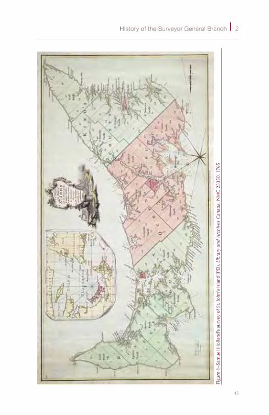
Figure2–TypicalDLSsurveyplan(Saskatchewan).95699CLSR.Surveyor General Branch.1901
19
History of the Surveyor General Branch 2
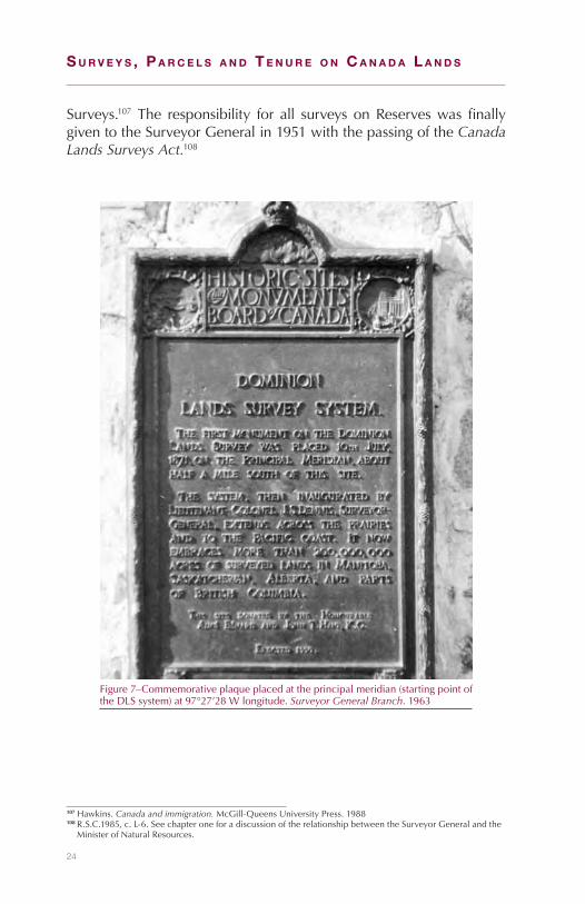
Fortuitously,anexpedientsystemofsurveywasinuseintheUnitedStates.Indeed,theCanadianGovernmentapprovedDennis’suggestionofaverysimilarsurveysystemin1869.82TheproposedsystemhadasitsfoundationtheAmericandesign,butwasalsoinfluencedbyDennis’surveyingcareerinOntariowhichledtotheinclusionofanallowanceforpublicroadsintheoverallarea(sectionsweretobe200acreseach).ItwasalsoinfluencedbytheviewoftheLieutenant-GovernoroftheNorthwestTerritories,WilliamMcDougallthatadoptingandadaptingtheAmericansystemwasnecessary.MostofthesettlerswouldcomefromtheUnitedStatessoitwas“advisabletoofferthemlotsofasizetowhich theyhavebeenaccustomed.”83Thefirstuseof this surveysystemwasproposedforManitobabutwashaltedbytheRedRiverrebellion.84 InAprilof1871, thesurveysystemreceivedanoverhaulconsistingmainlyoftheroadallowancesbeingoneandahalfchainsaroundeachsection.85ThefirsteditionoftheManualofInstructionswasissuedtwoweekslater,86andamonthsubsequentthefirstofficialDominionLandSurveysmonumentwasplacedbyMilnerHartontheprincipalmeridianat97°27’28.87
What are some of the historical achievements of SGB since 1871?
Thomson has suggested that the expanse of the Dominion LandsSurveySystemacrossCanadais:“oneofthegreatestcivilengineeringtriumphs of all time” and that it is “unsurpassed for precision ofexecution, permanence of marking, and absence of subsequentlitigationoverpropertyboundaries.”88TheexpanseofthisuniformgridacrossCanada is remarkable; itwas certainly applied on amassivescale.Some178millionacres89areestimatedtohavebeensubdividedto the quarter section level.90 The establishment of the grid, andthe subsequent adherence to it hadabig impacton themovementof people in western Canada, relations between First Nations andgovernment,andontheallocationofresourcesingeneral.91
ThebestillustrationoftheBranch’sachievementsisinthedistinctivecheckeredpatternoflanddevelopment.Thegridbeganattheprime
82 OrderinCouncil1869–69983 McDougall.LettertoDennis,July10,1869. Public Archives of Canada.186984 Dennis.A short history of the surveys performed under the Dominion Lands System.Canada. 189285 OrderinCouncil1871–87486 Manual of Instructions for the Survey of Dominion Lands. 187187 McColl.AddressontheoccasionoftheunveilingoftheDominionLandSurveyhistoricmonument. The
Canadian Surveyor.193088 Thomson.Men and Meridians Vol 2.Canada. 196789 Forcomparisonpurposes,thisisthesameareaasFrance,andmuch,muchlargerthanGreatBritain.90 Dennis.TheworkofthetopographicalsurveyofCanada.Scottish Geographical Journal. 41:2,pp.89–97.192591 SpryandMcCardle.The records of the Department of the Interior and research concerning Canada’s western
frontier of settlement. UniversityofRegina.1993

20
S u r v e y S , P a r c e l S a n d T e n u r e o n c a n a d a l a n d S
meridian, justwestofWinnipeg,andwasdefinedbytownshiplinesrunningeast-west,andrangelinesrunningnorth-south.Eachofthesegridsquaresor‘townships’wasapproximately36squaremilesinsize.The township was further subdivided into 36 sections, each beingapproximatelyonemilebyonemilesquare(640acres).Typically,eachsection was subdivided into quarter sections which, as the namesuggests,makesfourquartersoutofeverysectioncomprising160acreseach.Surveymonumentswereusuallyplacedatsectionandquartersectioncorners,orapproximatelyeveryhalf-mile.92
The widespreadnaming of topo-graphic featuresacross the countryalso exemplifies theimpactoftheBranch.As but a smallsample, the regionalmunicipality ofRussell in Manitobais named after thesecond SurveyorGeneral of Canada,Lindsay Russell;Mount McArthurand McArthur Lakein Yoho NationalParkarenamedafterJ.J. McArthur, one
ofthefirstDominionLandSurveyorsintheRockyMountains;PetersLake,AlbertaandMountPetersnearBanffNationalParkarenamedafterF.H.Peters,SurveyorGeneralofCanadafrom1924-48.Branchsurveyorswereoften thefirstmapmakers toanarea, so thenamingofmanytopographicfeaturesfelltothem.Unnamedfeaturesweresoplentifulthatanomenclaturemanualwasintroducedin1888.93
Therewerealsomanynotableindividualcontributions.LindsayRussellwould preside over some of the most productive years of theDepartmentoftheInterior,including1883whenover27millionacres92 Thisisaverygeneraloverviewandapplyinganorthogonalgridtoasphericalworldisnotsosimple;
henceweseeentitiessuchascorrectionlines,baselines,jogs,andpartialsections.McKercherandWolfe.Understanding Western Canada’s Dominion Land Survey System. UniversityofSaskatchewan.1986
93 DominionLandSurveyorsAssociation.Memorandum regarding geographical nomenclature and orthography. Lovell.1888
Figure3–ShenanigansinasurveycampinTownship47,Range27,W5thMeridian(Alberta).Library and Archives Canada / PA-023022.1913

21
History of the Surveyor General Branch 2
weresurveyed,94morethandoubleanyotheryearonrecord.95EdouardDevillewas SurveyorGeneral for almost four decades (1885–1924),and received worldwide acclaim for his practical adaptation ofphotographyformappingpurposes.96Todaywecallitphotogrammetry.OttoKlotzwasemployedbythebranchasasurveyorontheprairiesand in the railway belt in British Columbia. He became the firstpresidentoftheDominionLandsSurveyors,establishedtheDominionLand observatory,97 and wrote some 100 publications.98 WilliamOgilvie spent nearly his entire career as a surveyor for the branch,mostly in the prairies, but also established the boundary betweenYukonandAlaska(141stmeridian),99laidoutDawsonCity,andservedasthesecondCommissioneroftheYukonduringtheheightofthegoldrush.100Again,theseexamplesaremerelyscratchingthesurface.
The expanse of theDominion Land Sur-veysystemremainedthe main focus oftheBranch for sometime.Theadministra-tion of a large por-tion of these landswas retained by thefederal governmenteven after the prov-inces entered Con-federation. The east-ern provinces (NewBrunswick, NovaScotia,Quebec, andOntario) were givenautonomy over theirlands(exceptasrequiredforfortressesandpurposesofdefense)whenthey signed on in 1867. Likewise, British Columbia kept control ofitsCrownlandswhenitenteredConfederationin1871,butcededa40mileswathalongthelengthoftheproposedrailwayline.
94 DepartmentoftheInterior.Annual Report of the Surveyor General. 188395 DepartmentoftheInterior.Report of the Topographical Survey of Canada. 192496 Andrews.EdouardGastonDanielDeville.The Canadian Surveyor. 30(1).pp.36–40.197697 Hodgson.The heavens above and the earth beneath: A history of the dominion observatories. Governmentof
Canada. 199498 Jarell.Klotz,OttoJulius.Dictionary of Canadian Biography. 200099 Green.The boundary hunters: surveying the 141st and the Alaska Panhandle. UBC.1982100Ogilvie.Early days on the Yukon. Read.1913
Figure4–Enjoyinga–25°Clunchalongafreshlycutline.Library and Archives Canada / PA-023034.1913

22
S u r v e y S , P a r c e l S a n d T e n u r e o n c a n a d a l a n d S
Manitoba,onlyaboutone-twentiethof itspresent sizeat thispoint,wasnotgivencontrolofitscrownlandswhenitsignedonin1870,norwhenitwaslaterenlargedin1881and1912(despitethefactthatOn-tario andQuebecwere given this control automaticallywhen theywereenlarged).SaskatchewanandAlbertawerealsodeniedcontroloftheirungrantedlandswhentheyenteredConfederationin1905.BritishColumbiawasalsonotpleasedaboutthefederalgovernmentretainingcontroloftherailwaybeltlandslongaftertherailwaywascompleted.Finallyin1930,andaftermuchcontroversy,thePrairieProvinceswereputonequalfootingwiththeireasterncounterparts,andrailwaybeltlandsweregivenback toBritishColumbia.101ThiseffectivelyendedtheDominionLandSurveyeraofthebranch.
The amount of workthat was undertakenbetween 1871 and 1930is illustrated poignantlyin the amount of papertransferred from thefederal government.The initial influx ofdocuments,maps,plans,memos, and letters totheprovincesfilledsome200railwaycars.Thisdidnot include the closedor dormant files whichfilled another 9000 filecabinets, andweighed ahefty227tons.102
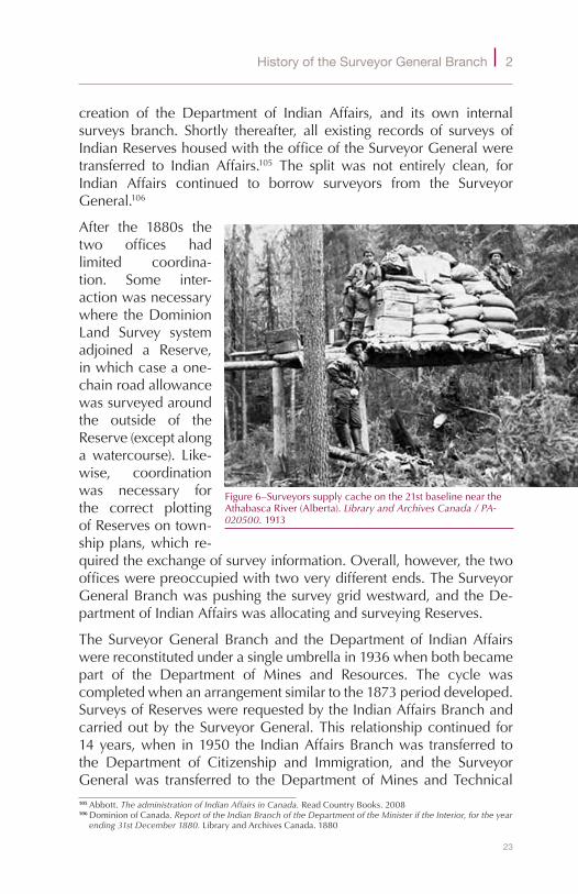
What is the historical relationship between SGB and Indian Affairs?
AttheinceptionoftheDepartmentoftheInterior103in1873andforseven years thereafter, the SurveyorGeneralBranch and the IndianAffairs Branch were both under one umbrella. Surveys of IndianReserveswerearrangedbytheSurveyorGeneralattherequestoftheIndian Affairs Branch.104 This arrangement ended in 1880 with the
101Gates.CanadianandAmericanLandPolicyDecisions,1930.The Western Historical Quarterly. v.15.no.4.pp.389–405.1984
102Giventhecomplexityofcataloguingsuchavolumeofinformation,thedebateastowhattodowiththesefilescontinueduntil1956whentheProvincestookthem.SpryandMcCardle.pg.9
103Statute36Victoria,c.4.1873104DominionofCanada.Report of the Indian Branch of the Department of the Minister if the Interior, for the year
ending 30th June 1873. LibraryandArchivesCanada.1873
Figure5–CookpreparingEasterSundaysupperforDLSsurveycamp.Library and Archives Canada / PA-023040. 1913
23
History of the Surveyor General Branch 2
creation of the Department of Indian Affairs, and its own internalsurveys branch. Shortly thereafter, all existing records of surveys ofIndianReserveshousedwiththeofficeoftheSurveyorGeneralweretransferred to Indian Affairs.105 The split was not entirely clean, forIndian Affairs continued to borrow surveyors from the SurveyorGeneral.106
After the 1880s thetwo offices hadlimited coordina-tion. Some inter-actionwasnecessarywhere theDominionLand Survey systemadjoined a Reserve,inwhichcaseaone-chainroadallowancewassurveyedaroundthe outside of theReserve(exceptalongawatercourse). Like-wise, coordinationwas necessary forthe correct plottingofReservesontown-shipplans,whichre-quiredtheexchangeofsurveyinformation.Overall,however,thetwoofficeswerepreoccupiedwithtwoverydifferentends.TheSurveyorGeneralBranchwaspushingthesurveygridwestward,andtheDe-partmentofIndianAffairswasallocatingandsurveyingReserves.
The SurveyorGeneralBranchand theDepartmentof IndianAffairswerereconstitutedunderasingleumbrellain1936whenbothbecamepart of the Department of Mines and Resources. The cycle wascompletedwhenanarrangementsimilartothe1873perioddeveloped.SurveysofReserveswererequestedbytheIndianAffairsBranchandcarriedoutby theSurveyorGeneral.This relationshipcontinued for14years,when in1950 the IndianAffairsBranchwas transferred tothe Department of Citizenship and Immigration, and the SurveyorGeneralwas transferred to theDepartment ofMines andTechnical105Abbott.The administration of Indian Affairs in Canada. ReadCountryBooks.2008106DominionofCanada.Report of the Indian Branch of the Department of the Minister if the Interior, for the year
ending 31st December 1880. LibraryandArchivesCanada.1880
Figure6–Surveyorssupplycacheonthe21stbaselineneartheAthabascaRiver(Alberta).Library and Archives Canada / PA-020500.1913
24
S u r v e y S , P a r c e l S a n d T e n u r e o n c a n a d a l a n d S
Surveys.107 The responsibility for all surveys onReserveswas finallygiventotheSurveyorGeneralin1951withthepassingoftheCanada Lands Surveys Act.108
107Hawkins.Canada and immigration. McGill-QueensUniversityPress.1988108R.S.C.1985,c.L-6.SeechapteroneforadiscussionoftherelationshipbetweentheSurveyorGeneralandthe
MinisterofNaturalResources.
Figure7–Commemorativeplaqueplacedattheprincipalmeridian(startingpointoftheDLSsystem)at97°27’28Wlongitude.Surveyor General Branch.1963
25
3First Nation Reserves
Who manages Reserves?
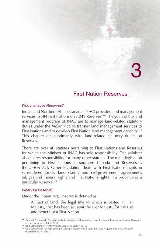
IndianandNorthernAffairsCanada(INAC)provideslandmanagementservicesto584FirstNationson3,049Reserves.109Thegoalsofthelandmanagementprogramof INACare tomanage land-related statutorydutiesundertheIndian Act,totransferlandmanagementservicestoFirstNationsandtodevelopFirstNationlandmanagementcapacity.110This chapter deals primarily with land-related statutory duties onReserves.
There are over 40 statutes pertaining to FirstNations and Reservesforwhich theMinisterof INAChas sole responsibility.TheMinisteralsosharesresponsibilityformanyotherstatutes.Themainlegislationpertaining to First Nations in southern Canada and Reserves isthe Indian Act. Other legislation deals with First Nations rights insurrendered lands; land claims and self-government agreements;oil,gasandmineralrightsandFirstNationsrightsinaprovinceoraparticularReserve.111
What is a Reserve?
UndertheIndian Act,Reserveisdefinedas:
A tract of land, the legal title to which is vested in HerMajesty,thathasbeensetapartbyHerMajestyfortheuseandbenefitofaFirstNation
109NationalFramework,CanadaLandsAdministrativeBoundaries,Level1.NaturalResourcesCanada,Geogratiswebsite.AccessedOct.7,2010.
110LandManagement:INACWebsite.AccessedOct.7,2010.111ForacompletelistoflegislationpertainingtoReservessee:Acts,BillsandRegulations:INACWebsite.
AccessedOct.7,2010.

26
S u r v e y S , P a r c e l S a n d T e n u r e o n c a n a d a l a n d S
Figure8–M
apofC
anadashow
inglocatio
nofFirstNationReserves.S
urve
yor
Gen
eral
Bra
nch.2010

27
First Nation Reserves 3
Reservealsoincludesdesignatedlands.112TheActdefines“designatedlands”as:
AtractoflandoranyinterestthereinthelegaltitletowhichremainsvestedinHerMajestyandinwhichtheFirstNationforwhoseuseandbenefititwassetapartasaReservehas,otherwisethanabsolutely,releasedorsurrendereditsrightsorinterests,whetherbeforeorafterthecomingintoforceofthisdefinition;
What was the nature of the early treaties?
Beginninginthelate15thcenturytheBritishandFrenchexploredandstartedtosettlelandintheeasternpartofCanada.TheEnglishinfluencewasmainlyinNewfoundlandandintheareaoflandknownasRupert’sLand.TheFrenchsettledalongtheSt.LawrenceRiverandaroundtheGreat Lakes. Early relationsbetween the FirstNations andboth theFrenchandtheEnglishfocusedondevelopingthefurtradeandcreatingmilitaryalliances.
The Government ofFrance entered intowritten treaties withFirst Nations whichwere peace treaties.Forexample,treatieswith the Haudeno-saunee (Iroquois) in1624,1645and1653and theGreatPeaceof Montreal in 1701wereessentiallynon-aggression pacts.113However,theJesuits,(FrenchCatholicmis-sionaries) coming tothe New World toseekconverts,estab-lishedFirstNationsettlementsattheirmissions.TheearlyFirstNationsettlementofSillerywasestablishedbytheJesuitsnearQuebecCity
112Subsection18(2),sections20to25,28,36to38,42,44,46,48to51,58to60oftheIndian Actandtheregulationsmadeunderanyofthoseprovisionsareexcepted.
113Report of the Royal Commission on Aboriginal Peoples (RCAP),Vol.1,PartOne,Chap.5-StageTwo,3.3Pre-ConfederationTreatiesinCanada,para.6.1996
Figure9–SurveyinginunusuallyhighwateronBusheRiverIR(Alberta).Surveyor General Branch.1957
28
S u r v e y S , P a r c e l S a n d T e n u r e o n c a n a d a l a n d S
in 1638.114 Later in the century, several similar settlementswere es-tablishedalongtheSt.LawrenceRiverbytheJesuits,someofwhichbecameReserves.
Startingin1725,anumberoftreaties,calledthepeaceandfriendshiptreaties, were made between the British Crown and the MicmacNation.TheMicmactribalterritoryincludedallofwhatarenowNovaScotia and Prince Edward Island, the Gaspe Peninsula of Quebec,thenorthshoreofNewBrunswickandinlandtotheSaintJohnRiverwatershed,easternMaine,partofNewfoundland, the islands in theGulfofStLawrence,andSt.PierreandMiquelon.115ThemainthrustofthetreatieswastoobtaintheloyaltyoftheMicmactotheBritish,and to proclaim KingGeorge as the rightful possessor of the land.However,anadditionaltreatyofpeacethatwassignedonNovember22,1752,containedtheprovisionthatthetribeshall“havefreelibertyofhuntingandfishingasusual”.116
What of the Royal Proclamation of 1763?
WhentheSevenYearsWarendedwiththeTreaty of Paris (1763),theBritishobtainedcontrolofmostof France’s land inNorthAmerica;present day Canada was firmly under Great Britain’s control. Theislands of St. Pierre and Miquelon were ceded by Great Britainto France, to serve as a shelter to the French fishermen. TheRoyal Proclamation of 1763provideddirectionforthemanagementofGreatBritain’sacquisitionsinNorthAmericaandstabilizedrelationswiththeFirstNations.UndertheProclamation:
◆ Nations or Tribes living under the protection of the BritishCrownwerenottobedisturbedinthepossessionoflandthathadnotbeencededtoorpurchasedbytheBritish.
◆ The “Sovereignty, Protection and Dominion” of the BritishCrownwas reserved for the use of the Indians of: “All theLands andTerritoriesnot includedwithin the LimitsofOursaid Three newGovernments117 or within the Limits of theTerritory granted to theHudson’sBayCompany, as also alltheLandsandTerritorieslyingtotheWestwardoftheSourcesoftheRiverswhichfallintotheSeafromtheWestandNorthWestasaforesaid.”
114The Jesuit Relations and Allied Documents: Travels and Explorations of the Jesuit Missionaries in New France, 1610—1791,Vol.XIV,Hurons,Quebec,1637–1638.
115 Johnson.TheMi’kmaq.In:The Encyclopedia of North American Indians.HoughtonMifflin:NewYork.pp.376-78.1996
116 IndianTreatiesCollection:GovernmentofNovaScotiaWebsite.Alsosee1752 Peace and Friendship Treaty Between His Majesty the King and the Jean Baptiste Cope.
117ThethreegovernmentsreferredtowereQuebec,EastFloridaandWestFlorida.

29
First Nation Reserves 3
◆ The purchase or settlement of lands within the lands andterritoriesdescribedabovewasforbiddenwithouttheBritishCrown’s“especialleaveandlicence”.
◆ Personswhohadalreadysettleduponthereservedlandsandterritorieswereto“removethemselvesfromsuchSettlements”.
◆ No private person was allowed to purchase from the FirstNationsanylandsreservedforthemwithinthecolonies.IftheFirstNationsshouldwishtodisposeofthelandsreservedforthemtheycouldonlybepurchasedbytheBritishCrownatapublicmeetingorassemblyofthecommunity,tobeheldforthatpurpose.
ProvisionsintheRoyal ProclamationregardingFirstNationlandswerehonouredmore in the breach than the observance in Nova Scotia(which at that time also included present day Prince Edward IslandandNewBrunswick).TheTreatyof1725hadbeendeemedsufficientto transfer sovereignty ofNova Scotia to theBritishCrownand theColonyhadbeenmakinglawsandarrangementsforFirstNationlandsand for Indian protection for several years.118 Few people removedthemselvesfromthelandsandterritoriesthattheyhadalreadysettledon.Nevertheless theRoyal Proclamation encouraged treatymakingandguidedfuturerelationshipswiththeFirstNations.
What was the effect of the American Revolution?
After the start of the American Revolution in 1775, great numbersofUnited Empire Loyalists flowed intoNova Scotia.Grants of landweregiventotheseLoyalistsandthisputadditionalpressureonthegovernmenttoreservelandsfortheFirstNations.119In1783theNovaScotia government gave several licences, or tickets of location, tothe Indians. Thesewerenot outright grants andonly confirmed theexistence of already established settlements or were given on thestrengthofpromisestoengageinagriculture.120
UnitedEmpireLoyalistsalsoflowedintoQuebec(whichatthattimeincludedpartsofpresentdayQuebecandOntario).Mostheadedtopresent dayOntario,121 but before they could settle on First Nationterritory theBritishCrownhad topurchase land fromthe localFirstNationcommunity.
118Foradiscussionontheapplicationofthe1763RoyalProclamationintheMaritimesseeSurtees.The Original People,1971,pp.59,60.AlsoseeNative Rights in Canada – second edition,pp.30,31,101.
119Cumming;Mickenberg(co-editors).Native Rights in Canada – second edition,1972,pp.102,103.120McGeeJr.The Native Peoples of Atlantic Canada: A history of ethnic interaction,1974,pp.75,76.121Mackenzie.A Short History of the United Empire Loyalists,1998.TheUnitedEmpireLoyalists’Associationof
CanadaWebsite.AccessedOct.8,2010.

30
S u r v e y S , P a r c e l S a n d T e n u r e o n c a n a d a l a n d S
LandwasalsorequiredfordispossessedmembersofFirstNationswhohadbeenloyaltotheBritish,suchastheSixNationsConfederacy-comprisedoftheMohawks,Oneidas,Onondagas,Cayugas,Senecasand Tuscaroras. In 1784 a tract of land along theGrandRiverwasgrantedbyGovernorFrederickHaldimandtotheMohawkIndiansoftheSixNations,122comprisingsomeofwhathadbeensurrenderedtotheBritishCrownbytheMississaugasIndianNation.123Thissurrenderwouldeventuallybeknownassurrender#3oftheUpperCanadaorpre-ConfederationTreaties.
How did the pre-Confederation treaties affect future negotiations?
ThegovernmentpurchasedseveralothertractsoflandfromtheFirstNationswhichweredeemedtobesurrendersortreaties.By1840mostofwhatisnowsouthwesternOntariohadbeencededbyFirstNationsfor settlementpurposes.124 It isestimated that therewereat least30major treaties signed during the pre-Confederation period between1764and1862.125
To accommodatemining interests, theRobinson Treatieswerenegotiatedwiththe Chippewa FirstNations in 1850 forthe north shores ofLake Superior andLake Huron. Severalaspects of thesetreatiessetapreced-ent for future treatynegotiations.126Inre-turn for surrender-ing their territory,Canada paid an in-itial settlement, pro-
videdforaperpetualannualannuity,andreservedtractsoflandthat
122Grant,GovernorHaldimandtotheSixNations.ILRInstrumentNumberX15173.AlsoseeIndian Treaties and Surrenders, Volume 1,1891,p.251.
123IndenturemadeatNiagarabetweentheMississaugaFirstNationandtheBritishCrown:ILRInstrumentNumberX15173.
124Patterson.Land Settlement in Upper Canada 1783–1840,1921,(OntarioArchives1920),p.232.125OntarioTreaties,UpperCanadaTreaties–establishingafoundationforthefuture,p.5:INACWebsite.
AccessedOct.8,2010.126Morris.The Treaties of Canada with the Indians,(Toronto,ProsperoBooks,2000),p.285.
Figure10–SettingamonumentonChapelIslandIR(NovaScotia).Surveyor General Branch.1960

31
First Nation Reserves 3
hadbeenselectedbythechiefs.TheRobinson-SuperiorTreatylistedthree“reservations”andtheRobinson-HuronTreatylisted17“reserva-tions”.TheFirstNationswerealsoallowedtohuntovertheterritoryceded by them and to fish in thewaters that they traditionally hadfishedin,exceptinareasthatweresoldorleasedbytheCrown.127
Bytheearly19thcentury,Reserves for First Na-tions (in many forms:lands in trust, licensesof occupation) had beenestablished. The transi-tion from hunting, fish-ing and gathering to anagricultural lifestyle onReserve was difficult forsomeFirstNations.128OntheReservetheysufferedfrom poverty and dis-ease, they were isolatedand they depended onthe Crown for subsist-ence. There were alsoproblemswithencroach-mentontoandadversepossessionofReserveland.Aswell,by1830themilitary,whohadtheresponsibilityofIndianaffairs,werequestion-ingthevalueofallianceswithFirstNationsfromamilitaryperspective,astheneedforalliesandthethreatofwarhadlessened.129
In 1842 theGovernment of Nova Scotia passed anAct to Provide for the Instruction and Permanent Settlement of the Indians130whichwasintendedtohelptheMicmac.Itprovidedassistancetoconstructhousingandforeducationandeconomicdevelopment.IntheProvinceofCanada,theBagotCommissionwasestablishedtostudyandreporton theproblem. Its 1844 report includedprovisions recommendingcentralizationofcontroloverallIndianmatters.ItalsorecommendedthatReservesbeproperlysurveyed.
127Morris.The Treaties of Canada with the Indians,(Toronto,ProsperoBooks,2000),pp.16–21,302–309.Although17reservationswerelistedintheRobinsonHuronTreaty,therewere21tractsofland,threeofthemislands.AlsoseeSurtees,TheRobinsonTreaties(1850),TheMakingoftheRobinsonTreaties:INACWebsiteandCanada’sFirstNations,TreatyEvolution,TermsofthePrairieTreaties:UniversityofCalgaryWebsite.
128McMillan.Native Peoples and Cultures of Canada,1988,p.51.129Surtees.DevelopmentofReservePolicyinCanada.Ontario History, Vol. LX1,June1969,No.2.p.87.130FirstNationHistory:DanielN.PaulWebsite.AccessedOct.8,2010.
Figure11–SurveyingnearirrigationchannelonSiksikaIR(Alberta).Surveyor General Branch.1963
32
S u r v e y S , P a r c e l S a n d T e n u r e o n c a n a d a l a n d S
In order to promote a spirit of free enterprise and to eventuallyobtain the goal of full citizenship, the Bagot Commission reportrecommended that FirstNations be encouraged to adopt individualownershipofparcelsofland.Theyweretobeencouragedtobuyandselltheirparcelsamongthemselvesasawayoflearningmoreaboutthenon-FirstNationslandtenuresystemandtopromoteaspiritoffreeenterprise.TheeliminationoftheReservesystemwastobegradual-inthemeantime,nosalesofFirstNationslandtonon-Indiansweretobepermitted.IndividualownershipnevermaterializedastheFirstNationsfeareditwouldleadtothelossoftheirlands.However,manyoftherecommendationsoftheBagotCommissionwereadoptedinoneformoranotherinlaterprovinciallegislationandcontinue,toagreatextent,inlegislationtoday.131
What was the effect of the Indian Act, 1876?
UnderSection91(24)oftheConstitution Act, 1867 (The British North American Act, 1867) the Parliament of Canada obtained exclusivelegislativeauthorityfor“Indians,andLandsreservedfortheIndians”.TheIndian Act of 1876essentiallyconsolidatedtwopre-Confederationacts,132andappliedtoalltheprovincesandtheNorth-WestTerritories.It defined the system of Reserves to be set aside for members ofFirstNationswhoadhered toa treaty.Under theActaFirstNationmembercouldobtainlawfulpossessionofland.TherewasprovisionforcompensationfordamagetoReservelandasaresultofanyrailway,roadorpublicworkonaReserve.Also,noReserveorportionofaReservecouldbe“sold,alienatedorleased”untilareleaseorsurrenderof the land to theCrownwasassented toby theFirstNation.SuchprovisionsremaininsomeformoranotherinthecurrentIndian Act.133
What was required after 1867 before the prairies could be settled?
OnceRupert’sLandwaspartoftheDominionofCanadathepriorityof the government was to open the land for settlement. However,CanadafirsthadtomaketreatieswiththeFirstNations.In1871thefirstnumberedtreatywassigned.ThenumberedtreatiescededtheterritorytheFirstNations inhabited,andcontinued theright tohuntandfishovercededterritory“exceptingsuchportionsoftheterritoryaspassfromtheCrownintotheoccupationofindividualsorotherwise”.They
131RCAP,Vol.1,PartTwo,Chapter9-TheIndianAct,4.CivilizationtoAssimilation:IndianPolicyFormulated.132An Act providing for the organization of the Department of the Secretary of State of Canada, and for the
management of Indian and Ordnance Lands(1868);An Act for the gradual enfranchisement of Indians, the better management of Indian affairs, and to extend the provisions of the Act(1869).HistoricalLegislation:INACWebsite.BothoftheseActstoagreatextentwerebasedonpreviousColoniallegislation.
133R.S.C.1985,c.17.

33
First Nation Reserves 3
promisedaReserveinproportiontopopulation.Theyalsopromisedannuities(annualcashpayments),agriculturalimplements,stockandseedgraintoencourageranchingandfarmingandtheyprovidedfortheestablishmentofschools.134
Alexander Morriswrote in 1880:“Since 1870, no lessthan seven treatieshave been conclud-ed, with the Indiantribes, so that therenow remain no In-dian nations in theNorth-West,insideofthe fertile belt, whohave not been dealtwith.”135 In 1889,eighty-six Reserves,withintheareascov-ered by Treaties 4,6 and 7, and part ofTreaty 2, were con-firmedbyOrder-in-Council(OIC).The1889OICisaccompaniedbyplansanddescriptionsof86Reservesallboundinwhatiscalled‘Nel-son’sBook’,namedafterJ.C.Nelson,whowasresponsibleforsurveysfortheDepartmentofIndianAffairs.136
By1921,elevennumberedtreatieshadbeenratifiedbetweentheFirstNationsandtheGovernmentofCanadaonbehalfoftheBritishCrown.RegionsaffectedbythetreatiesincludedallofAlberta,SaskatchewanandManitobaandpartsofBritishColumbia,OntarioandtheNorthwestTerritories.
How were First Nations in British Columbia addressed?
Between1850and1854SirJamesDouglas,governoroftheColonyofVancouver Island, entered into 14 agreements (called the DouglasTreaties)withtheFirstNationsofsouthernVancouverIsland.However,hewasnot able toobtain funds from theBritishColonialOffice to
134Morris.The Treaties of Canada with the Indians,(Toronto,ProsperoBooks,2000),pp.285–292.135Morris.The Treaties of Canada with the Indians,1880.p.10.136P.C.1151(May18,1889)accompaniedbyDescriptionsandPlansofCertainReservesintheProvinceof
ManitobaandtheNorth-WestTerritories,1889,ILRInstrumentNumber4000.
Figure12–SurveyingontheprairiesthroughSiksikaIR(Alberta).Surveyor General Branch.1965

34
S u r v e y S , P a r c e l S a n d T e n u r e o n c a n a d a l a n d S
continuetopurchaseFirstNationslands.Aswell,therewasagrowingunwillingnessamongthesettlerpopulationtorecognizeFirstNations’rightstoland.Whilenofurthertreatiesweremadeafter1854,DouglascontinuedtoassignReservestoFirstNationswhichincludedareasoflandusedassettlements,graveyards,gardens,hunting lodges,berrypatches,orfishingstations.137
In 1866 the Colony ofVancouver Island wasunited with the ColonyofBritishColumbia.Brit-ish Columbia’s policy isfoundinan1870memo-randum from JosephTrutch, then SurveyorGeneralofBritishColum-bia,totheColonialGov-ernor: “The title of theIndians......hasneverbeen acknowledged bytheGovernment,but,onthe contrary, is distinctlydenied.”Hegoeson:“Buttheseclaimshavebeenheldtohavebeenfullysatisfiedbysecuringtoeachtribe…theuseofsufficienttractsoflandfortheirwantsforagricultureandpastoralpurposes.”138
When British Columbia joined Confederation in 1871, CanadarequestedinformationonReservesthathadbeenestablishedinBritishColumbia.Alistof76ReserveswassubsequentlysubmittedtoCanada;however,manyReservesintheprovincewerenotincludedinthelist.139After 1871, acreage allocationand the establishmentof reserves fortheremainingFirstNationswasamatterofconsiderablecontroversy.Canadarequestedmuchlargerareasforeachfamilythantheprovincewaspreparedtooffer.In1876thefederalandprovincialgovernmentsagreedtotheformationoftheJointAllotmentCommissiontosetasideReserve lands.140 The process included consulting with each First
137Cail.Land, Man and the Law – The Disposal of Crown Lands in British Columbia, 1871–1913,1974,pp.171–175.
138Cail.Land, Man and the Law,p.184.139Cail.Land, Man and the Law,pp.189,190.Papers Connected with the Indian Land Question, 1850–1875
(Victoria:QueensPrinter1875),pp.136,138,141.140Cail.Land Man and the Law,p.207.
Figure13–CoweatingphotocontroltargetonSixNationsIR(Ontario).Surveyor General Branch.1965
35
First Nation Reserves 3
Nation,sketchingthelocationoftheReserve,followedbyasurveyandapprovalofthesurvey.141
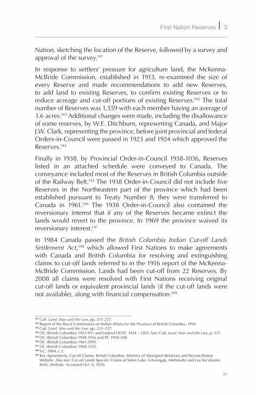
In response to settlers’ pressure for agriculture land, theMcKenna-McBride Commission, established in 1913, re-examined the size ofevery Reserve and made recommendations to add new Reserves,to add land to existingReserves, to confirm existingReserves or toreduceacreageandcut-offportionsofexistingReserves.142ThetotalnumberofReserveswas1,559witheachmemberhavinganaverageof3.6acres.143Additionalchangesweremade,includingthedisallowanceofsomereserves,byW.E.Ditchburn,representingCanada,andMajorJ.W.Clark,representingtheprovince,beforejointprovincialandfederalOrders-in-Councilwerepassedin1923and1924whichapprovedtheReserves.144
Finally in1938,byProvincialOrder-in-Council1938-1036,Reserveslisted in an attached schedule were conveyed to Canada. TheconveyanceincludedmostoftheReservesinBritishColumbiaoutsideoftheRailwayBelt.145The1938Order-in-CouncildidnotincludefiveReserves in theNortheastern part of the provincewhich had beenestablished pursuant to Treaty Number 8; they were transferred toCanada in 1961.146 The 1938 Order-in-Council also contained thereversionary interest that if any of the Reserves became extinct thelandswould revert to theprovince. In1969 theprovincewaived itsreversionaryinterest.147
In 1984 Canada passed the British Columbia Indian Cut-off Lands Settlement Act,148 which allowed First Nations tomake agreementswith Canada and British Columbia for resolving and extinguishingclaimstocut-offlandsreferredtointhe1916reportoftheMcKenna-McBrideCommission.Landshadbeencut-off from22Reserves.By2008 all claims were resolved with First Nations receiving originalcut-off landsorequivalentprovincial lands(if thecut-off landswerenotavailable),alongwithfinancialcompensation.149
141Cail.Land, Man and the Law,pp.217–227.142ReportoftheRoyalCommissiononIndianAffairsfortheProvinceofBritishColumbia,1916143Cail.Land, Man and the Law,pp.233–237.144OC(BritishColumbia)1923-911andFederalOCPC1924–1265.See:Cail,Land, Man and the Law,p.237.145OC(BritishColumbia)1938-1036andPC1930-208.146OC(BritishColumbia)1961-2995.147OC(BritishColumbia)1969-1555.148S.C.1984,c.2.149KeyAgreements,Cut-offClaims.BritishColumbia,MinistryofAboriginalRelationsandReconcillation
Website.Alsosee:Cut-offLandsSpecificClaimsofSetonLake,Gitwangak,MetlakatlaandLaxKw’alaams.INACWebsite.AccessedOct.8,2010.

36
S u r v e y S , P a r c e l S a n d T e n u r e o n c a n a d a l a n d S
Where is land interest information maintained?
There isprovisionfora landregistrationsysteminsection21of theIndian Act:
There shall be kept in the Department a register, to beknown as the Reserve Land Register, in which shall beenteredparticularsrelatingtoCertificatesofPossessionandCertificatesofOccupationandothertransactionsrespectinglandsinaReserve.
TheIndianLandRegistry(ILR)islocatedinGatineau,Quebec.TheILRwillonlyacceptdocumentsforregistrationthatconformtotheIndian Act.150 It will not register unauthorized transactions or transactionswhich it does not recognize or administer, such as customaryallotments,leasesandpermits(bucksheeagreements),allofwhicharegrantedoutsidetheIndian Act.151
In recent years consider-able resources havebeen spent moderniz-ing the system and de-veloping on-line access.Now,virtuallyallILRdatais obtained on-line fromthe ILR System accessedthroughINAC’sElectronicServicesWebsite.ALandStatusReportmayalsobeobtainedfromINAC.Thereport contains pertinentinformationregardingen-cumbrancesand/orinter-estsonaparticularparcelofReserve landfromtheILRand,ifavailable,from
appropriatedepartmentalfiles.Itidentifiesexistingregisteredinterestsorpossibleencumbrancessuchascardexholdingsordesignations.152
The Act also provides for a register for transactions related tosurrendered and designated lands. Surrenders and designations areenteredintotheILR.INAC’sElectronicServicesWebsitealsoincludes150AgreementsundertheIndian Oil and Gas Regulationsarealsoacceptedforregistration.151LandManagementManual,Chapter2,Directive2-3,Part2.3,p.29.152LandManagementManual,Chapter7,Directive7-1,Part2.2(c),p.4.
Figure14–BlackflyconditionsonChickenIR225(Saskatchewan).Surveyor General Branch.1968
37
First Nation Reserves 3
aLandsSalesSystemforinformationpertainingtolandswhichhavebeensurrenderedforsale.
SomelandsmayhavebeeninprovincialjurisdictionpriortobecomingaReserve.Inthesecasesolderlandtransactiondocumentspertainingtothelandsmaybefoundinprovincialorterritoriallandtitlesoffices,landregistrationofficesandofficesmaintainingpubliclandsrecords.
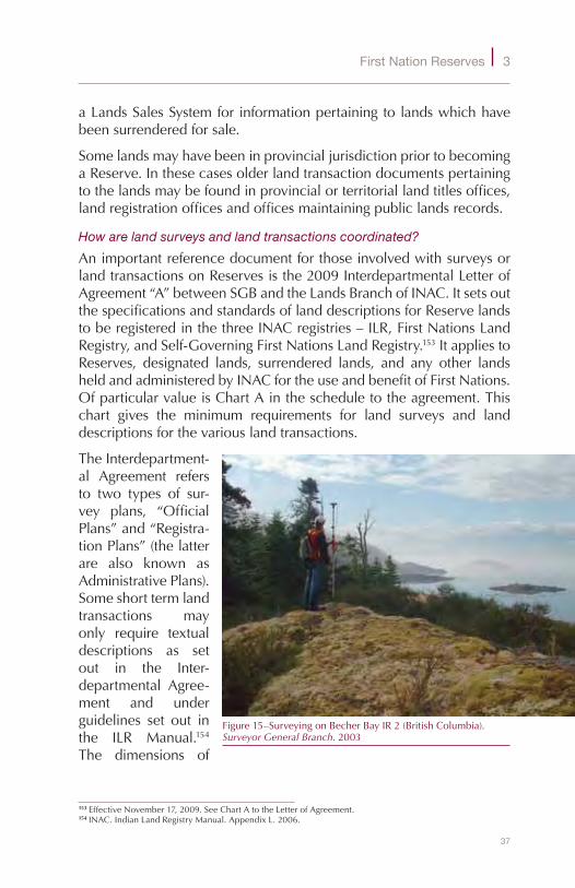
How are land surveys and land transactions coordinated?
AnimportantreferencedocumentforthoseinvolvedwithsurveysorlandtransactionsonReservesisthe2009InterdepartmentalLetterofAgreement“A”betweenSGBandtheLandsBranchofINAC.ItsetsoutthespecificationsandstandardsoflanddescriptionsforReservelandstoberegisteredinthethreeINACregistries–ILR,FirstNationsLandRegistry,andSelf-GoverningFirstNationsLandRegistry.153ItappliestoReserves, designated lands, surrendered lands, and any other landsheldandadministeredbyINACfortheuseandbenefitofFirstNations.OfparticularvalueisChartAinthescheduletotheagreement.Thischart gives the minimum requirements for land surveys and landdescriptionsforthevariouslandtransactions.
TheInterdepartment-al Agreement refersto two types of sur-vey plans, “OfficialPlans”and“Registra-tionPlans”(thelatterare also known asAdministrativePlans).Someshorttermlandtransactions mayonly require textualdescriptions as setout in the Inter-departmental Agree-ment and underguidelines set out inthe ILR Manual.154The dimensions of
153EffectiveNovember17,2009.SeeChartAtotheLetterofAgreement.154INAC.IndianLandRegistryManual.AppendixL.2006.
Figure15–SurveyingonBecherBayIR2(BritishColumbia).Surveyor General Branch.2003
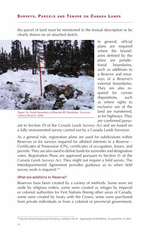
38
S u r v e y S , P a r c e l S a n d T e n u r e o n c a n a d a l a n d S
theparceloflandmustbementionedinthetextualdescriptionorbeclearlyshownonanattachedsketch.
In general, officialplans are requiredwhere the bound-aries defined by theplans are jurisdic-tional boundaries,such as additions toaReserveand resur-veys of a Reserve’sexternal boundaries.They are also re-quired for certaindispositions, suchas where rights toexclusive use of theland are transferred,asforhighways.Theyareconfirmedpursu-
anttoSection29oftheCanada Lands Surveys ActandarebasedonafullymonumentedsurveycarriedoutbyaCanadaLandsSurveyor.
Asageneral rule, registrationplansareused for subdivisionswithinReservesor for surveys required forallotted interests inaReserve–CertificatesofPossession(CPs),certificatesofoccupation,leases,andpermits.Theyarealsousedtodefinelandsforsurrenderanddesignationvotes.RegistrationPlansareapprovedpursuant toSection31of theCanada Lands Surveys Act.Theymightnotrequireafieldsurvey.TheInterdepartmental Agreement provides guidance as to when fieldsurveyworkisrequired.155
What are additions to Reserve?
Reserveshavebeencreatedbyavarietyofmethods.Someweresetasideby religiousorders, somewerecreatedas refugesby imperialorcolonialauthoritiesforFirstNationsfleeingotherareasofCanada,somewerecreatedbytreatywiththeCrown,somewerepurchasedfromprivateindividualsorfromacolonialorprovincialgovernment,
155SeetheGeneralInstructionsforSurvey,e-Edition,PartB–Agreements:SGBWebsite.AccessedOct.8,2010.
Figure16–NorthboundaryofBrochetIR(Manitoba).Surveyor General Branch.2006

39
First Nation Reserves 3
some were created by provincial governments after Confederation,andsomeweresimplyrecognizedasReservesbytheCrown.156
Even today there isnostatutoryprocedureunder the Indian Act,oranyotherfederallegislation,tosetasidelandasaReserve.AlandmarkcasedealingwiththeconditionsrequiredtocreateaReserveisRoss River Dena Council First Nation v. Canada, 2002.157 TheRossRiverFirstNationhadsettledinavillageintheYukonandadisputearoseconcerning the status of the village. TheCourt determined that thevillagewasnotaReserve,because:
◆ theCrownmusthavehadanintentiontocreateaReserve;◆ the intention must be possessed by Crown agents holdingsufficientauthority;
◆ steps must be taken in order to set apart the land for thebenefitofIndians;
◆ theFirstNationconcernedmustacceptthesettingapartandmusthavestartedtomakeuseofthelands.
The most common and clearest procedure, once the land is heldby the federalCrown, is togrant the landReserve statusby federalOrder-in-Council(OIC),orbyministerialorder,pursuanttotheRoyalPrerogative.158 All land interestsmay not be included in the federaltitle. For example,mines andmineralsmay not be included or theinterestmaybeonlyausufruct(arighttouseandenjoytheland).159TherearethreereasonstoaddlandtoaReserve:160
◆ Legal obligations: Land claim settlement agreements, courtordersandlegalreversionsofformerReserveland.161
◆ Community additions: Based on a need from an increasein on-IR population; from geographic enhancements to anexistingReserve;fromsmalladjustments,suchasroadright-of-waycorrections,accretionandunsoldsurrenderedland.
◆ Allproposals foradditions toReservesornewReservesnotcoveredbytheothertwocategories.
156RCAP,Vol.1PartTwo,Chapter9-TheIndianAct,Seenote17.Alsosee:LaForest.Natural Resources and Public Policy under the Canadian Constitution,1969,p.121.
157SCC54,[2002]2S.C.R.816.158“RoyalPrerogative”meansthepoweroftheCrown,asrepresentedbytheGovernorinCouncil,totakeaction
asanexerciseofitsexecutivepower.SettingasideReservesisonesuchpower.SeetheLandManagementManual,Chapter10,Directive10-1,Part2.1,p.7,andPart3.12,p.9.
159ForanexampleofanusufructseeP.C.1979-2178whichacceptedatransferassetoutinQuebecexecutiveOrder-in-Council1851-79(ILRRegistrationNos.65619,65618)fortheJamesBayandNorthernQuebecAgreement.Itdescribedthenatureofthelandstransferredas:“administration,managementandcontrol.........fortheexclusiveuseandbenefitoftheCreeFirstNations...”
160LandManagementManual,Chapter10,Directive10-1,pp.5–14.161Seechapter4foradiscussionofthecomprehensiveandspecificclaimsprocesses.
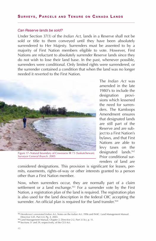
40
S u r v e y S , P a r c e l S a n d T e n u r e o n c a n a d a l a n d S
Can Reserve lands be sold?
UnderSection37(1)oftheIndian Act, landsinaReserveshallnotbesold or title to them conveyed until they have been absolutelysurrendered to Her Majesty. Surrenders must be assented to by amajority of First Nation members eligible to vote. However, FirstNationsarereluctanttoabsolutelysurrenderReservelandssincetheydonotwish to lose their landbase. In thepast,wheneverpossible,surrenderswereconditional.Onlylimitedrightsweresurrendered,orthesurrendercontainedaconditionthatwhenthelandwasnolongerneededitrevertedtotheFirstNation.
The Indian Act wasamended in the late1980’stoincludethedesignation provi-sionswhichlessenedthe need for surren-ders. The KamloopsAmendment ensuresthatdesignatedlandsare still part of theReserveandaresub-jecttoaFirstNation’sbylaws,andthatFirstNations are able tolevy taxes on thedesignated lands.162Priorconditionalsur-renders of land are
considereddesignations. This provision is significant for leases, per-mits,easements, rights-of-wayorother interestsgranted toapersonotherthanaFirstNationmember.
Now, when surrenders occur, they are normally part of a claimsettlement or a land exchange.163 For a surrender vote by the FirstNation,aregistrationplanofthelandisrequired.TheregistrationplanisalsousedforthelanddescriptioninthefederalOICacceptingthesurrender.Anofficialplanisrequiredforthelandtransfer.164
162Henderson’s annotated Indian Act,NotesontheIndian Act.1996andINAC.LandManagementManual.Directive5.01,Part4.4,Pg.4.2003.
163LandManagementManual,Chapter2,Directive2-2,Part3.13c),p.11.164Sections31and29,respectively,oftheCLSAct.
Figure17–NaturalboundaryofCowessessIR73(Saskatchewan).Surveyor General Branch.2005

41
First Nation Reserves 3
What is a Special Reserve?
The Indian Actdefinesa specialReserveasa tractof land thathasbeen“setapartfortheuseandbenefitofaFirstNationandlegaltitletheretoisnotvestedinHerMajesty.”ThepurposeofthissectionwastobringwithintheauthorityoftheIndian Actlandsheldbychurchesor charitable organizations in trust for Indian communities. UnderINACpolicynonewspecialReserveswillbecreated.165
What is a Certificate of Possession (CP)?
ACP is documentary evidence of the highest formof land holdingavailabletoanindividualFirstNationmember.Itdiffersfromfeesimpletitleinthattherearerestrictionsontransfer.Itispermanent,asitcanbeinheritedortransferredtootherFirstNationmembers.166However,italsohas limitations.MortgagesrequireFirstNationorgovernmentguaranteesasthelandisimmunefromseizure.Itcannotbetransferredtonon-FirstNationmembers.IfaCPholderceasestobeentitledtoreside on the Reserve, she (or he)may transfer her (or his) right topossessiontotheFirstNationoranothermemberoftheFirstNation.Ifnot,thenwithinsixmonthsorsuchfurtherperiodastheMinistermaydirect,therighttopossessionofthelandrevertstotheFirstNation.167
Before aCP is issued,possessionof the landmustbe allottedbyaBand Council Resolution.168 Also, the parcel must be defined, as aminimumbyaregistrationplan.IftheMinisterapprovestheallotmentitisregisteredintheIndianLandRegistry(ILR)andaCPisissuedasevidenceof lawfulpossession.169SomeReserveshavenoCPs,someno longerallowCPs,and some (suchas theSixNationsReserve inOntario)haveover10,000CPs.170
Evidenceof lawfulpossessionof landprior to1951wasby locationtickets.Under Section 20(3) of the Indian Act any personwho, onSeptember 4, 1951, held a valid and subsisting Location Ticket islawfullyinpossessionofthelandandholdsaCPwithrespectthereto.CardexHoldings andNotices of Entitlement are also recognized aslawful possession. They have been created by an allotment by theFirstNationCouncilandapprovedby theMinisterunderc.20 (1)oftheIndian Act.However,theirlanddescriptionsarevagueandoften
165LandManagementManual,Chapter10,Directive10-6,Part3,p.70.166Indian Act,RSC1985,c.I-5,ss.24&49.167Indian Act,RSC1985,c.I-5,s.25(1,2).168Indian Act,RSC1985,c.I-5,s.20(1).169LandManagementManual,Chapter3,Directive3-2,Part2.7,p.7.170FlanaganandAlcantara.Individual Property Rights on Canadian Reserve,FraserInstitute,2002,p.7.
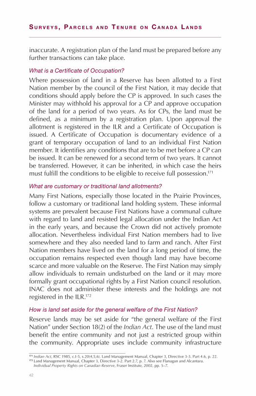
42
S u r v e y S , P a r c e l S a n d T e n u r e o n c a n a d a l a n d S
inaccurate.Aregistrationplanofthelandmustbepreparedbeforeanyfurthertransactionscantakeplace.
What is a Certificate of Occupation?
Where possession of land in a Reserve has been allotted to a FirstNationmemberbythecounciloftheFirstNation,itmaydecidethatconditionsshouldapplybeforetheCPisapproved.InsuchcasestheMinistermaywithholdhisapprovalforaCPandapproveoccupationof the land foraperiodof twoyears.As forCPs, the landmustbedefined, as a minimum by a registration plan. Upon approval theallotment is registered in the ILRandaCertificateofOccupation isissued. A Certificate of Occupation is documentary evidence of agrant of temporary occupation of land to an individual FirstNationmember.ItidentifiesanyconditionsthataretobemetbeforeaCPcanbeissued.Itcanberenewedforasecondtermoftwoyears.Itcannotbetransferred.However,itcanbeinherited,inwhichcasetheheirsmustfulfilltheconditionstobeeligibletoreceivefullpossession.171
What are customary or traditional land allotments?
ManyFirstNations,especiallythoselocatedinthePrairieProvinces,followacustomaryortraditionallandholdingsystem.TheseinformalsystemsareprevalentbecauseFirstNationshaveacommunalculturewithregardtolandandresistedlegalallocationundertheIndianActin theearlyyears,andbecause theCrowndidnotactivelypromoteallocation.Nevertheless individualFirstNationmembershad to livesomewhereandtheyalsoneededlandtofarmandranch.AfterFirstNationmembershavelivedonthelandforalongperiodoftime,theoccupation remains respected even though landmay have becomescarceandmorevaluableontheReserve.TheFirstNationmaysimplyallowindividuals to remainundisturbedon the landor itmaymoreformallygrantoccupationalrightsbyaFirstNationcouncilresolution.INAC does not administer these interests and the holdings are notregisteredintheILR.172
How is land set aside for the general welfare of the First Nation?
Reserve landsmaybe set aside for “thegeneralwelfareof theFirstNation”underSection18(2)oftheIndian Act.Theuseofthelandmustbenefit the entire community andnot just a restricted groupwithinthe community. Appropriate uses include community infrastructure
171Indian Act,RSC1985,c.I-5,s.20(4,5,6).LandManagementManual,Chapter3,Directive3-3.Part4.6,p.22.172LandManagementManual,Chapter3,Directive3-2.Part2.7,p.7.AlsoseeFlanaganandAlcantara.
Individual Property Rights on Canadian Reserve,FraserInstitute,2002,pp.5–7.

43
First Nation Reserves 3
projects (roads, sewers, airports), schools, community halls, healthofficesandburialgrounds.Section18(2) isnotusedforcommercialoreconomicdevelopmentpurposes.Apersonwhohadpossessionofthelands,priortoaSection18(2)taking,isentitledtocompensationfor loss of use.173 The parcelmust be defined, as aminimum by aregistrationplan.
What rights in land can non-First Nation members obtain?
Designations,underSection38(2)oftheIndian Act,areusedwhereaFirstNationwishes to grant an interest inReserve land to apersonotherthanaFirstNationmember.AdesignationismadetoHerMajestyandmustbeassentedtobyamajorityofFirstNationmemberseligibletovote.Althoughleasesarethemostcommontypeofinterestgranted,permits,easements,orrights-of-waymayalsobegranted.AdesignationdoesnotextinguishtheFirstNationinterest,butitdoesextinguishtheindividual (locatee) interest.174 The parcel must be defined, as aminimumbyaregistrationplan.
A lease grants aninterest in and ex-clusivepossessionofReserve lands. It isgrantedforaspecificperiodoftime,oftenforalongterm.Com-mercial, residentialand recreational de-velopments leasesare normally issuedpursuant to Sec-tion 53(1), followingdesignation.175 Theparcel is normallydefinedbyaregistra-tion plan, althoughspecific circum-stancesmayrequireahigherproduct.
173Indian Act,RSC1985,c.I-5,s.18(2).LandManagementManual,Chapter2,Directive2-2,Part3.18,pp.16,17,Chapter4.
174LandManagementManual,Chapter2,Directive2-2,Part3.14,p.12.175LandManagementManual,Chapter2,Directive2-2,Part3.15,p.13.AlsoseeChapter7.
Figure18–MembertouIR(NovaScotia).Surveyor General Branch.2007

44
S u r v e y S , P a r c e l S a n d T e n u r e o n c a n a d a l a n d S
A locatee lease is a lease of allocated land (land held by a CP orCertificateofOccupation) toanother FirstNationmember, theFirstNation, or a third partywhere the benefit of the lease goes to thelocatee.Locateeleasesareissuedundersection58oftheIndian Act.UnderINACpolicy,FirstNationcouncilsmusthavetheopportunitytoexpresstheirviewsonthistypeofleasepriortoministerialapproval.Asalong-termleasemaybeseenasconflictingwiththedesignationprovisionsoftheIndian Act,avoteofFirstNationmembersisrequiredforall locatee leasesofmore than49years.176A registrationplan isonlyrequirediftheleaseisforaperiodof10yearsorlonger.Likeallleases,alocateeleasegrantsaninterest inandexclusivepossessionof the land for a specificperiodof time. For agricultural or grazingpurposes,apermitunderSection28(2)oftheActispreferred.177
UnderSection58(1)(c)oftheAct,wherelandinaReserveisuncultivatedorunusedandwherethelandisnotinthelawfulpossessionofanyindividual,theMinistermaygrantaleaseforthepurposesofagricultureorgrazing.Thistypeofleaseisrare;asection28(2)permitispreferredforagriculturalorgrazingpurposes.178
Under Section 28(2)oftheIndian Act theMinister may permitany person for aperiod not exceed-ingoneyear(orwiththe consent of thecouncil of the FirstNationforanylongerperiod) to occupy,use or otherwiseexercise rights onan Reserve. Thesepermits are usedfor utility servicesto the Reserveand for grazing oragriculturalpurposes
whereexclusiveuseisnotrequired.179Sinceapermitdoesnotgrant
176LandManagementManual,Chapter2,Directive2-2,Part3.16,p.14.177LandManagementManual,Chapter2,Directive2.2,Part3.16,p.14.178LandManagementManual,Chapter2,Directive2.2,Part3.15,p.13.179LandManagementManual,Chapter2,Directive2.2.Part3.17,p.15.
Figure19–SurveyingonPiikaniIR147(Alberta).Surveyor General Branch.2007
45
First Nation Reserves 3
exclusivepossession,morethanonepermitforaparceloflandmaybeissuedtodifferentpartiesfordifferentpurposes,aslongastheusesdonotconflict.Aregistrationplanisonlyrequiredifthepermitisforaperiodof10yearsorlonger.
Permits are also issued under Section 58(4) of the Act. Under thisSection, the Minister may, without an absolute surrender or adesignation,disposeofwildgrassordeadorfallentimber.WiththeconsentofthecounciloftheFirstNation,theMinistermaydisposeofsand,gravel,clayandothernon-metallicsubstances.
It is common in some communities for individual First NationmembersortheFirstNationitselftoenterintoagreementsforothersto use Reserve land outside the provisions of the Indian Act. Suchagreementsarecommonlyreferredtoasbucksheeleasesandvaryinthesophisticationoftheirdocumentation.Theynormallydependonthetrustandgoodwillofthepartiestotheagreement.Sincebucksheeagreements are not authorized under the Indian Act, INAC neitherrecognizes themnorcollectsrentsorothercompensationrelated tothem.180
Can Reserve land be expropriated?
If Reserve land is required for a public use such as a highway, ahydro transmission line, or a railway, and the province, municipallocal authority or corporation that requires the land has statutoryexpropriation powers, then the land may be taken or used underSection35of the Indian Act. TheFirstNationandaffected locateesreceivecompensationforthelossoflandortheirinterestinthelands.
ItisthepolicyofINACtofirstobtaintheconsentoftheFirstNationcouncil. The only exception may be where the national interest isparamount.Also,beforeusingSection35(3),thepossibilityofusingasurrenderordesignationofthelandorapermitunderSection28(2)oftheActshouldbeinvestigated.TheCrownisobligatedtoensurethattheinteresttransferredistheminimumrequiredtofulfilltherequiredpublicuse.181
Are the exterior boundaries of all Reserves surveyed?
Initially,parcelsoflandsetasideforFirstNationsweredefinedbylanddescription.Forinstance,thedescriptionofthelandinthe1680GrantfromLouisXIV,KingofFrancetotheEcclesiasticsoftheCompanyof
180LandManagementManual,Chapter8,Directive8-2,Part2,pp.12–14.181LandManagementManual,Chapter2,Directive2-2,Chapter9-1.Part2.4,p.5

46
S u r v e y S , P a r c e l S a n d T e n u r e o n c a n a d a l a n d S
JesusresidinginlaNouvelleFrancefortheuseoftheIroquoisreadsasfollows:
WerewenotpleasedtograntthemthelandcalledtheSault,containing two leagues of frontage, beginning at a pointopposite theSt.LouisRapids,ascendingalongthelakeinsimilardepth,withtwoIslands,IsletsandtheBeach,lyingopposite andadjoining the landsof the saidPrairie de laMagdelaine182
ThelanddescribedaboveisforthepresentdayKahnawakeReserveNo.14nearMontreal.ThefirstrecordedsurveyofthisReserveintheCanadaLandsSurveyRecordsisdated1880.183NowmostrectilinearboundariesofReservesinCanadahavebeensurveyed.However,notallwaterboundarieshavebeensurveyed,andeveniftheyhavebeentheremaybesubstantialchangesasaresultoferosionoraccretion.
What of internal parcel fabric?
InteriorsubdivisionsvaryfromReservetoReserve.Thetypeofinteriorsubdivision is often influenced by adjacent provincial systems. Forexample, in Quebec, Reserves are likely subdivided into river lots(seigneuries).InOntariomanyReserveshavebeensubdividedintolotandconcessionsurveysystemsasusedinprovinciallands.InManitoba,SaskatchewanandAlberta,manyReserveshavebeensubdivided inthesamemannerastheoriginal townshipsurveyscarriedoutat theendofthe19thandbeginningofthe20thcenturiesintheseprovinces.In theAtlanticProvincesandinBritishColumbia,where there isnodistinct homogeneous survey system, interior subdivisions are oftendeterminedbylandholdingsandtopography.
InsomeReservesthereisadisconnectionbetweenactualoccupation(as evidenced by improvements), the surveyed parcel and the landdescriptionsintheILR.Inothercases,engineeringsurveysareused,particularly in Reserves that have customary or traditional landallotments.AnalysisbytheSurveyorGeneralBranchtodeterminetherelationship between internal parcel fabric, community well-beingon Reserves and the location of Reserves, found a strong positivecorrelation:
182Indian Treaties and Surrenders (Ottawa). Vol.1,p.13.1680Grant,TheGrantisalsoregisteredintheILR,RegistrationNumber5481-169.
183IndianLandsHistoryinQuebec:SGBWebsite.AccessedOct.8,2010.

47
First Nation Reserves 3
◆ betweengoodparcelfabric(whereimprovementsconformtothesurveyedparcels)andcommunity socio-economicwell-being,and
◆ between good parcel fabric and proximity to urbanareas, owing to the economic opportunities (markets andemployment)providedbythelatter.184
What is the statutory authority for surveys?
SurveysaremadeundertheCanada Lands Surveys Act ontherequestoftheMinisterofINAC.Section19oftheIndian Act setsoutthattheMinistermay:
◆ authorizesurveysofReserveandthepreparationofplansandreportswithrespectthereto;
◆ dividethewholeoranyportionofaReserveintolotsorothersubdivisions.
How are surveys managed?
Prior toundertakinga surveyonaReserve, a surveyor requires theapproval of the FirstNation council.Aperson seeking to acquire aparcelofReservelandmustprovidefundingforanysurveysrequired.Usually the First Nation or individual First Nation members fundsurveysoflandallottedbythecouncil.OnceapprovalfromtheFirstNationisobtained,specificsurveyinstructionsarerequiredfromtheSurveyorGeneral.AfterthesurveyiscompletedaplanofthesurveyissubmittedtotheFirstNationcouncilandtoINACforapproval.ItisthenreviewedbytheSurveyorGeneralBranch(SGB)toensurethatitmeetssurveystandards.Ifitissatisfactoryitisapproved(registrationplans)orconfirmed(officialplans)andrecordedintheCanadaLandsSurveysRecords.
Inadditiontoitsregulatoryfunction,theSGBprovidessurveyrelatedsupport including contractmanagement for INAC. The SGB also isinvolved in arranging for surveys of provincial lands which are tobecomeReserves.Inthosecases,surveysarecarriedoutinaccordancewithprovinciallegislation.StandardsforthesurveyofCanadaLandsarealsofollowediftheprovincialCrownagreesandthereisnoconflictwithprovinciallegislationandsurveystandards.
184Marginalia,OfficeoftheSurveyorGeneralofCanada,Issue01,December2008.

S u r v e y S , P a r c e l S a n d T e n u r e o n c a n a d a l a n d S
48

49
4Initiatives on Aboriginal lands
Yet another chapter?
Yes.TherearevariousinitiativesthataffecttheboundariesandparcelsofCanadaLandsinwhichAboriginalpeopleshaveaninterest,andthatoccuroutsideoftheIndian Act185andinsouthernCanada.186SomeoftheseinitiativesaredrivenbyAboriginalpeoples,somebyjudgmentsof thecourts, someby legislation,andsomeby federalgovernmentpolicy.
What is Aboriginal title?
Aboriginal title recognizes the fundamental truth that Aboriginalpeoples lived in (what is now) Canada for many millennia beforeother peoples arrived.187 The first Canadians are thought to havemigratedover a landbridge (Beringia) betweenwhat is presentdayAsiaandAlaskaintheLatePleistoceneera.188Suchlong-termuseandoccupationofthelandmeantthatAboriginalpeopleshadtitletotheland–itwastheirs.Intheabsenceofcession,thelandremainstheirs.Ina1979claim toaportionof landatBakerLake in (what isnow)Nunavut,thecourtfoundthattheInuitweretheexclusiveoccupantsofaparcelatthetimeofCrownsovereignty,describedas“theportionofthebarrenlandsextendingfromthevicinityofBakerLakenorthandeasttowardtheArcticandHudsonBaytotheboundariesoftheBakerLakeR.C.M.P.detachmentareaastheywerein1954.”189
185TheIndian Actiscomprehensivelycoveredinchapter3.186Thus,theinitiativesarenotcapturedbychapters7–9.187Calder v. British Columbia (A-G)[1973]SCR313.188Braceetal.OldWorldsourcesofthefirstNewWorldhumaninhabitants:Acomparativecraniofacialview.
Proceedings of the National Academy of Science (USA). 98:10017-22.2005189Baker Lake v. Canada,(1979)107DLR(3d)513(FCTD).

50
S u r v e y S , P a r c e l S a n d T e n u r e o n c a n a d a l a n d S
Although much of Canada has been ceded through treaties andagreements,BritishColumbiaislargelybereftoftreaties,meaningthatAboriginalpeoples thereareat thecusp indefiningAboriginal title.ThetheoryisthatanAboriginalgroup,whichoccupiedland(inwhatisnowBritishColumbia)atthetimethatBritishsovereigntywasimposed(in 1846) andwhichnever ceded its right to the land, continues toenjoytitletoit.
Inthe1997DelgamuukwdecisionoftheSupremeCourtofCanada,190theGitksan andWet’suwet’en FirstNations claimedAboriginal titleto133parcelsof landinnorth-westernBC.Attrial, theclaimswererejected for various reasons, one ofwhichwas that the boundariesof theparcelshadnotbeendefined.Onappeal, thecourtheldthat“… there was significant difficulty with the delineation of specificboundariesfortheclaim.Itisclearthatnoonecanownanundefinednon-specificparcelofland.”AttheSupremeCourt,theFirstNationstried to amalgamate the 133 parcels into two large parcels thatencompassedthesamearea,suchthat“theexternalboundariesofthecollectiveclaimsthereforerepresenttheouterboundariesoftheouter[133]territories.”Thisargumentwasrejected.
So, boundaries and parcels are important in asserting Aboriginal tile?
Yes,theboundariesoftheparcelsbeingclaimedmustbewelldefined,assetoutintheTsilhqot’indecisionoftheBritishColumbiaSupremeCourt (2007).191 The Tsilhqot’in Nation claimed Aboriginal title to420,000haoflandincentralBC,south-westofWilliamsLake.Therewasnodoubt that theFirstNationhadoccupied landssincebeforethearrivalofnon-Aboriginalpeoples,andcertainlysincebefore theassertionofBritishsovereigntyin1846.NorwasthereanydoubtthattheFirstNationhadnevercededtheirlandstotheCrown.Therewasdoubt,however,astowhatlandswerebeingclaimed;thelocationandspatialextentofthelandswasverymuchindoubt.
ThecourtscornedboththeCrowns’andtheFirstNation’sapproachtoparcels.TheCrowns(bothBCandCanada)arguedfora“postagestamp”approach,inwhicheachspecificsiteandtrailwastobedescribedasauniqueparcel.TheFirstNationsarguedforvaguerapproachtoparcels.Forinstance,thesoutherlyboundaryoftheclaimedareawasdescribeddifferentlybythreeAboriginalwitnesses.Thatis,thecharacterandthelocationoftheboundarywereinconsistentlydefined.Suchambiguity
190Delgamuukw v. British Columbia,[1997]3SCR1010.191Tsilhqot’in Nation v. British Columbia, 2007BCSC1700.
51
Initiatives on Aboriginal lands 4
extendedtotherebeingFirstNationsitesbothinsideandoutsidetheclaimedarea.Thus,thecourtwasunabletoconcludethattherewassufficientoccupationoftheclaimedareaasawhole.
Ifthespatialextent(andthus,theboundaries)oftheparcelshadbeendefined,thentheFirstNationwouldhavebeengrantedAboriginaltitletosome190,000ha.Intheabsenceofsuchagrantoftitle(flounderingonboundaries,asitwas),theFirstNationwasgrantedAboriginalrightsintheclaimedarea:tohuntandtrapbirdsandanimalsforspecifiedpurposes,andtotradeinskinsandpelts.Moreover,thecourtheldthattheTsilhqot’inNation’sAboriginalrightsintheclaimedareahadbeenunjustifiablyinfringedbyforestryactivities.192
What are Aboriginal land claims?
SomeofCanadaisblanketedbyTreatieswhichdealwiththecessionoflandandrightsbytheFirstNationsforthepromiseofalternatelands(Reserves)orotherprovisions.OtherpartsofCanadahaveneverdealtwiththeissueofAboriginallandclaims.Thissplitsfederalpolicyontheissueintotwobroadcategories:
◆ Comprehensive land claims are based on the assertion ofcontinuingAboriginalrightsandtitlethathavenotbeendealtwithbytreatyorotherlegalmeans.
◆ “Specific claims generally, refers to claimsmade by a FirstNation against the federal government which relate to theadministrationoflandandotherFirstNationassetsandtothefulfillmentofIndiantreaties,althoughthetreatiesthemselvesarenotopentorenegotiation.”193
What of comprehensive claims?
ThetreatynegotiationprocessdidnotincludeallAboriginalgroupsinBritishColumbiaandnorthernCanada(NL,Quebec,Nunavut,NWTandYukon).Morseassertsthatthetreatiesthemselvesbecameperceivedas“anachronisticdocumentsthathadoutlivedtheirpurposeandweretoneitherberenewednor replicatedelsewhere”.194Additionally, thetreatieswerenotregardedaslegallybindingdocuments.195Althoughthisviewhasbeendebunkedmorerecently,intheearly20thcenturyitunderminedthetreaty-makingprocessforallparties.Indeed,aslate
192InFebruary2009thetwoCrownsweregiventherighttoappealthetrialjudgment.193INAC.The Specific Claims Policy and Process Guide. Ottawa.2009194Morse.Indigenous-SettlerTreatyMakinginCanadainLangtonetal.Honour among Nations? Treaties and
Agreements with Indigenous People. MelbourneUniversityPublishing.pg.61.2004195R v. Syliboy, [1929]1D.L.R.307(N.S.Co.Ct)at313

52
S u r v e y S , P a r c e l S a n d T e n u r e o n c a n a d a l a n d S
as1969,comprehensiveclaimswereregardedasbeingsovagueastobeincapableofanyspecificremedy.196
In1973,Canadaenactedanewpolicyinwhichcomprehensivelandclaims agreementswould be negotiated for areaswhere Aboriginaltitlehadnotbeenextinguished.197Sincethen,23comprehensivelandclaimshavebeensettled:
◆ James Bay and Northern Quebec Agreement(1975) andNortheastern Quebec Agreement (1978)–Quebec;
◆ Inuvialuit Final Agreement (1984)–westernArctic;◆ Gwich’in Agreement (1992)–YukonandNWT;◆ Nunavut Land Claims Agreement (1993)–Nunavut;◆ ElevenYukon First Nation Final Agreements (1993through2008)–Yukon;
◆ Sahtu Dene and Metis Agreement (1994)–NWT;◆ Nisga’a Final Agreement (2000)–BC;◆ Tlicho Agreement (2003)–NWT;◆ Labrador Inuit Agreement (2005)–NewfoundlandandLabrador;
◆ Nunavik Inuit Land Claims Agreement (2006)–Quebec;◆ Tsawassen First Nation Final Agreement (2007)–BC;◆ Maa-nulth First Nations Final Agreement (2009)–BC.198
Thescopeof thecomprehensivelandclaimshasevolvedovertime.Early agreement (such as James Bay) had “more limited land rights,hunting rights and financial compensation” and “outright self-government provisions were not included”.199 More recently, in theNunavut agreement over 350 000 km2 of land in fee simple wasgranted,$1.17billionincompensationwasgiven,andthecreationofaNunavutgovernmentwasagreedto.IntheNisga’a agreement,over1900km2oflandintheNassRiverValleywasgrantedinfeesimple,$190millionwaspaid,subsurfacerightsweregranted,andtheNisga’aCentralGovernment(andvillagegovernments)wasestablished.
What of specific claims?
Unlike comprehensive claims, specific claims were regarded in the1969White Paperasbeingcapableofspecificremedy,meaningthat“lawful obligations must be recognized”. Specific claims generallyrelateto:196Statement of the Government of Canada on Indian Policy, 1969 (WhitePaper).197INAC.Statement of claims of Indian and Inuit People. Ottawa:Queen’sPrinter.1973198Hurley.Settlingcomprehensivelandclaims. Library of Parliament. PRB09-16E.2009199Dalton.AboriginalTitleandSelf-GovernmentinCanada:Whatisthetruescopeofcomprehensiveland
claimsagreements?.Windsor Review of Legal and Social Issues. Vol.22,29-78.2006

53
Initiatives on Aboriginal lands 4
◆ failurebythegovernmenttofulfilltreatypromises;◆ the breach of obligations under the Indian Act or otherlegislation;
◆ mismanagement of reserve lands, Indianmoneys and otherassets;and
◆ theillegalleaseordispositionofreservelands.200
In the 1990s, the specific claims process was criticized as beingweighted too favorably in Canada’s favor, such that settlementswere infrequent and First Nations dissatisfied.201 In 2007, Canadaannouncedanactionplantospeedupresolutionofspecificclaims,202bycompletingstepsinthespecificclaimsprocesswithinthreeyears.Canadahasthreeyearstoassessafiledclaimtodeterminewhetheritwillbeacceptedfornegotiationandthreeyearstonegotiateacceptedclaimstosettlement.Ifthistime-frameisnotmet,thentheFirstNationhastheoptionofsendingtheclaimtoanindependentSpecificClaimsTribunalforbindingresolution.203AsofSeptember,2009,728specificclaimshavebeenconcludedwithonly623filedclaimsremainingintheinventory.204
How does Treaty Land Entitlement (TLE) fit into the mix?
Manyof thehistoricTreatiesmade landpromises. In thenumberedTreatiesacrosstheprairiesthepromisewasofonesquaremileforafamilyoffive,or128acresperindividualIndian.205Historically,how-ever, therehavebeen significant shortfalls in theallocationof land.Compounding theproblem is that this simple formula (populationxarea)hasbecomeriddledwithinterpretationquestions.206
Enter TLE. In1992, a framework agreementwas signedbyCanada,Saskatchewan,and25FirstNationstofulfilloutstandinglanddebts.207Asimilaragreementwassignedwith19FirstNationsinManitobain1997.Theagreementsprovidefora“specifiedamountofCrownLands…and/oracash settlement…so thataFirstNationmaypurchasefederal,Provincial/territorial,orprivatelandtosettlethelanddebt”.208
200CompensationfordamagedlandsandfraudbyagentsoftheCrownarealsogroundsforaspecificclaim:INAC.The Specific Claims Policy and Process Guide. Ottawa.2009
201Hendersonetal.SurveyofAboriginalLandClaims.Ottawa Law Review. Vol26:1.1994202INAC.Specific Claims: Justice at last.Ottawa.2007203AssetoutintheSpecific Claims Tribunal Act. 2008,c.22204INAC.Resolving specific claims – results from March 31, 2008 to September 30, 2009. 2009205WiththeexceptionofTreaty5whichprovidesfor160acresperfamilyof5,or32acresperperson.206“Whoiseligibletobecounted,whenisthecountingtobegin,whenisittoendorbecompleted,andwhat
istobedoneifnoteveryonewascountedwhenthefirstcountingoccurred.”–Metcsetal.LandEntitlementunderTreaty8.Alberta Law Review. Vol.41(4).2004
207Saskatchewan Treaty Land Entitlement Framework Agreement. SignedSeptember22,1992208INAC.Frequently Asked Questions – Treaty Land Entitlement. 2009
54
S u r v e y S , P a r c e l S a n d T e n u r e o n c a n a d a l a n d S
Presently,over90%ofallTLEclaimsareinManitobaandSaskatchewan.In Saskatchewan, 22 of the original 25 FirstNations have had theirTLEclaimssettled.AsofOctober2009,some759,191acresattainedReservestatus.209InManitoba,over1.3millionacreswillbeconvertedto Reserves, of which some 335 000 acres had been allocatedby early 2010.210 TLE has also provided the opportunity for FirstNationstoacquirelandwithinurbanareas,thusenhancingaccesstoeconomic opportunities.An example isMuskeg LakeCreeNation’sAsimakaniseekanAskiy102A,a35acreReserveinSaskatoonthatishometo45businessesandorganizations.211
SGBisinvolvedintheTLEprocessbyprovidingadviceandconsultation,carryingouthistoricallandtitlesearches,managingsurveycontracts(surveysaremadeunderprovincialactsandregulations)andpreparingandreviewinglegaldescriptionsofthelandfororders-incouncil.
What of legislative initiatives?
Thereareat least fourpiecesof federal legislation thatarecolouredby INAC’s 1990 policy of devolution, such that First Nations andotherAboriginalpeoplesassumegreatercontrolovertheiraffairsandthereby increase their self-sufficiency. Three of them deal directlywithboundariesandparcelsofCanadaLands–FNLMA,FNCIDAandFNOGMMA.212
What is the First Nations Land Management Act (FNLMA)?
TheFNLMAwasenacted in1999 to allowFirstNations tomanagelandswithin their respectiveReserves. Itwas the result of some10years of discussions between First Nations and Canada about howto make the devolution policy meaningful, and had two sets ofprecedents. The first set involved co-management and delegationunder the Indian Act. Co-management was allowed through theRegionalLandAdministrationProgramme,althoughaccountabilityforlandmanagement functionscontinuedtoresidewith theMinisterofIndianAffairs.TheLandManagementDelegationProgrammeallowedFirstNationssomeresponsibilityforlandmanagementonReserves.213
209Treaty Land Entitlement Fact Sheet. GovernmentofSaskatchewan.October16,2009210INAC.TLE Report for Completed Land Conversions. March22,2010211Backgrounder-UrbanIR:AQuietSuccessStoryandCanadaInvestsinMuskegLakeCreeNation’s
CommercialDevelopmentinSaskatoon:INACWebsite.212ThefourthistheFirst Nations Fiscal and Statistical Management Act, S.C.2005,c.9.213Pursuanttoss.53and60oftheIndian Act.

55
Initiatives on Aboriginal lands 4
Figure20–Ingreen:420000
haclaimedbytheTsilqot’inNation.In
Blackdashed:190
000
hathatth
ecourtw
ouldhave
grantedtoth
eFirstN
ationhaditbeenclaim
ed.S
urve
yor
Gen
eral
Bra
nch.200
9

56
S u r v e y S , P a r c e l S a n d T e n u r e o n c a n a d a l a n d S
However, themoresignificantprecedentwastheFramework Agree-ment on First Nation Land Management,signedbetweenCanadaand14FirstNationsinFebruary1996.TheFramework AgreementallowedFirstNationstooptoutofthelandmanagementsectionsoftheIndian Actbyassumingsuchresponsibilitythemselves.TheFNLMAratifiedtheFramework Agreementthreeyearslater.
The FNLMA requires that participating FirstNationsdevelop a landcode,whichdealswithamyriadof issues:revenuesfromlandsandnaturalresources,conflictsofinterestanddisputeresolution,existingand new interests granted on Reserve, marriage breakdown, FirstNation’s laws,and theuse (occupationandprotection)of the lands.The landssubject to the landcodemustbe legallydescribed,usingeitherametesandbounds(written)descriptionoraparcelonaplanofsurvey(graphicaldescription).214
AportionofaReservemaybeexcludedfromtheapplicationofalandcode if surveyed under Part II of theCanada Lands Surveys Act.215Excludedlandmustbe:
◆ in an environmentally unsound condition that cannot bequicklyremedied;
◆ subjecttolitigationthatcannotbequicklyresolved;◆ uninhabitableowingtoanaturaldisaster;or◆ justifiedbytheFirstNationandtheMinister.
AportionofaReservemaynotbeexcludedfromalandcodeiftheeffectoftheexclusionistoplacetheadministrationofaninterestintwo regimes. For example, a parcel of Reserve land that is leasedcannotbepartiallywithin(subjecttotheFNLMA)andpartiallyoutside(subjecttotheIndian Act)thelandcodearea.
AFirstNationsLandRegistry–essentiallyasub-setoftheIndianLandRegistry–hasbeenestablishedtorecordinstrumentsfromthoseFirstNationsthathaveenactedalandcode.216Ofthe14FirstNationswhosignedtheFrameworkAgreement,sixnowoperateundertheFNLMA,meaningthattheyhaveenactedlandcodes.Since1999,another44FirstNationshaveenteredtheFNLMA,25ofwhichareoperational.
FNLMAlandscontinueasReserves,meaningthattheycontinuetobeCanadaLands.SometimesaFirstNationhas theuseandbenefitof
214FNLMA,s.6.1.215FNLMA,s.7.216First Nations Land Registry Regulations,pursuanttos.25(3)oftheFNLMA.October2007.
57
Initiatives on Aboriginal lands 4
onlyoneReserve(oneparcelofland);217othertimesithastheuseandbenefitofmanyReserves.218A legaldescription is required foreachReserve that is to be subject to a land code. SGBprepares a LegalDescriptionReport(LDR)thatcontainsthelegaldescription,asketch(oftencomprisingaerialphotographs),andtheinstrumentsandplansofsurveythatwereused,andthatidentifiesboundaryandtitleissues.AlthoughanopinionisrenderedontheboundaryoftheReserve(ortheportionsubjecttothelandcode),titleissues(suchasthestatusofroadsortheextentofminerals)arereferredtoINAC.SometimestheReservemustbesurveyed;atothertimesexistingsurveysandimagerysuffice. Surveys (and re-surveys) are usually contracted to CanadaLandsSurveyorsintheprivatesector.
What is the First Nation Commercial and Industrial Development Act (FNCIDA)?
FNCIDA is a mechanism by which a First Nation can request thatCanada develop regulations for a specific commercial or industrialdevelopmentonReserve.ItdoesnotextendprovincialregulationsontoReserve,but it tends tomimic such regulations.This givespotentialpartnersandprivatesectorinvestorsgreatercertaintyby“ensuringthattheyaredealingwith regulationsandregulators that theyknowandunderstand”.219
It also bridges a regulatory gap, where federal laws do not matchthe needs of commercial activity on reserve, andwhere provincialregulations are not permitted on Reserve for constitutional reasons.AsofJune30,2010,BillC-24toamendFNCIDAhadpassedthroughParliamentandhadreceivedRoyalAssent.ItentitlesFirstNationstorequestthatthe:
Government of Canada make regulations respecting theestablishmentandoperationofasystemfortheregistrationofinterestsandrightsinreservelandsthatwouldreplicatetheprovinciallandtitleorregistrysystem.220
217TheMississaugasofScugogIslandFirstNation,whichhasenactedalandcode,hastheuseandbenefitofoneReserve.
218TheScia’newFirstNation,whichhasenactedalandcode,hastheuseandbenefitofeightReserves.219INAC.Frequently Asked Questions – First Nations Commercial and Industrial Development Act. 2008220Bill C-24: First Nations Certainty of Land Title Act. 2010.

58
S u r v e y S , P a r c e l S a n d T e n u r e o n c a n a d a l a n d S
Figure21–Mapsho
wingoverlapp
ingclaimedareasinBritishColum
bia.G
over
nmen
t of C
anad
a an
d B
ritis
h C
olum
bia.200
7

59
Initiatives on Aboriginal lands 4
BillC-24allowsforaconsequentialamendmenttosection24oftheCanada Lands Surveys Act,221 such that Canada Lands would notincludeReservelandsdescribedinregulationsmadeundersection4.1ofFNCIDA.TheeffectistoretainthelandsasReserve,whilesurveyingthe lands to provincial standards, thus allowing the parcels to beregisteredinaprovinciallandtitlessystem.
What is the First Nations Oil and Gas Moneys Management Act (FNOGMMA)?
FNOGMMA,enactedNovember2005,enablesthedevolutionofthemanagementandregulationofoilandgasexplorationtoFirstNationswhichaccedetothenewmanagementregime.ManagementauthoritycurrentlyresideswithIndianOilandGasCanada,aspecialoperatingagency of INAC.222 The purpose of FNOGMMA is to improve theeconomicefficiencyofFirstNations.223
What is the duty to consult and the honour of the Crown?
Recent judgments of the courts have highlighted the necessity ofrigorous, meaningful consultation with Aboriginal peoples by theCrown.ThekeySupremeCourtofCanada(SCC)messagemotivatingthedutytoconsultistheneedtoreconcileAboriginalrightswiththoseofallotherCanadians.224TheTaku River225judgmentsetoutthat“theCrown’sdutytoconsultandaccommodateAboriginalpeoples,evenpriortoproofofassertedAboriginalrightsandtitle,isgroundedintheprincipleofthehonouroftheCrown.”
ThedutyisincumbentontheCrownwhenithas“knowledge,realorconstructive,ofthepotentialexistenceoftheAboriginalrightortitleand contemplates conduct thatmight adversely affect it.” The dutyrestswiththeCrown,meaningthatitisalsoincumbentuponprovincialgovernments.The scopeofconsultationdependson the strengthofthe assertion ofAboriginal interests, andon the “seriousness of thepotentiallyadverseeffectontherightortitleclaimed.”226
221Seechapter1forafullexposéofs.24.222Seechapter5forafulldiscussionofhowoilandgasrightsaremanagedandsurveyedonReserves.223Black.DevolutionofoilandgasjurisdictiontoFirstNationsinCanada.45Alberta Law Review537,2007-08.224Mikisew Cree First Nation v. Canada, [2005]3SCR388,2005SCC69.225Taku River Tlingit First Nation v. British Columbia2004SCC74,[2004]3SCR550.226Haida Nation v. British Columbia (Minister of Forests), [2004]3SCR511.
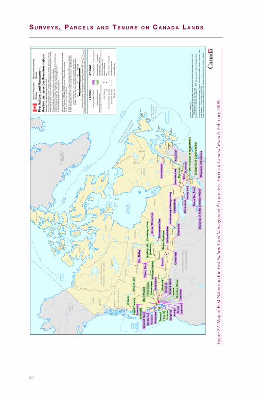
60
S u r v e y S , P a r c e l S a n d T e n u r e o n c a n a d a l a n d S
ATLA
NTI
C O
CE
AN
OC
ÉA
N A
TLA
NTI
QU
E
Gul
f of
St.
Law
renc
eG
olfe
du
Sai
nt-L
aure
nt
St. Law
rence
Rive
r
Fleuve
Sain
t-Lau
rent
Lake
Ont
ario
Lac
Ont
ario
Lake
Erie
Lac É
rie
Lake
Hur
onLa
c H
uron
Lake
Mic
higa
nLa
c M
ichi
gan
Lake
Sup
erio
rLa
c Su
périe
r
Jam
es
Bay Ba
ieJa
mes
PAC
IFIC
OC
EA
NO
CÉ
AN
PAC
IFIQ
UE
Beau
fort
Sea
Mer
de
Bea
ufor
t
Parr
y C
hann
el
Baffi
n Ba
yBa
ie d
e Ba
ffin
Davis Strait
Détroit de Davis
Foxe
Bas
in
Foxe
Cha
nnel
Huds
on S
trait
Détro
it d'
Huds
on
Ung
ava
Bay
Bai
e d'
Ung
ava
Labr
ador
Sea
Mer
de
Labr
ador
Hud
son
Bay
Bai
e d'
Hud
son
YU
KO
N
NO
RTH
WE
ST
TER
RIT
OR
IES
NU
NAV
UT
BR
ITIS
H C
OLU
MB
IA
ALB
ER
TA
SA
SK
ATC
HE
WA
NM
AN
ITO
BA
ON
TAR
IO
QU
EB
EC
NEW
FOUN
DLAN
D AN
D LA
BRAD
OR
P.E
.I
N.S
.
N.B
.
Baffi
n Is
land
Som
erse
tIs
land
Prin
ce o
f W
ales
Isla
nd
Ban
ks
Isla
nd
Mel
ville
Is
land
Prin
ce P
atric
k
Isla
nd
Vict
oria
Isla
nd
Sou
tham
pton
Isla
nd
Elle
smer
e Is
land
CO
LOM
BIE
-BR
ITA
NN
IQU
E
KA
LAA
LLIT
NU
NA
AT(D
EN
MA
RK
)
TER
RIT
OIR
ES
DU
NO
RD
-OU
ES
T
QU
ÉB
EC
TERR
E-NE
UVE-
ET-L
ABRA
DOR
N.-B
.
N.-É
.
Î.-P.
-É.
UN
ITE
D S
TATE
S O
F A
ME
RIC
A
ÉTA
TS-U
NIS
D'A
MÉ
RIQ
UE
ALA
SK
A(U
.S.A
)
SA
INT-
PIE
RR
E E
T M
IQU
ELO
N(F
RA
NC
E)
Qué
bec
Otta
wa
Reg
ina
Barr
ie
Sydn
eyVe
rnon
Hal
ifax
Toro
nto
Cal
gary
Nan
aim
o
Bran
don
Tim
min
s
Sudb
ury
Mon
cton
Iqal
uit
Edm
onto
n
Win
nipe
g
Vict
oria
Kam
loop
s
Cor
nwal
l
Vanc
ouve
r
Sask
atoo
nPe
ntic
ton
Moo
se J
aw
Nor
th B
ay
Dar
tmou
th
Whi
teho
rse
St. J
ohn'
s
Leth
brid
ge
Chi
cout
imi
Sain
t Joh
n
Yello
wkn
ife
Fred
eric
ton
Baie
-Com
eau
Med
icin
e H
at
Pete
rbor
ough
Fort
McM
urra
y
Prin
ce A
lber
t
Troi
s-R
iviè
res
Saul
t Ste
. Mar
ie
Tsaw
out
Slia
mm
on
T'So
u-ke
Kits
elas
Kin
istin
Sau
lteau
x
Mus
koda
y
Nip
issi
ng
Opa
skw
ayak
Cre
eM
uske
g La
ke
Whi
teca
p D
akot
a
Lhei
dli T
'enn
ehM
cLeo
d La
ke
Squi
ala*
Scia
'new
Tsaw
was
sen
Wes
tban
k**
Ts'k
w'a
ylax
w
Tsei
l-Wau
tuth
Shxw
há:y
Vill
age
Chi
ppew
as o
f Geo
rgin
a Is
land
Mis
siss
auga
s of
Scu
gog
Isla
nd
Dok
is
Pasq
ua
Nan
oose
Oso
yoos
Cow
esse
ssSw
an L
ake
Ald
ervi
lle
Che
maw
awin
Cre
e
Fort
McK
ay
Mis
siss
auga
Moo
se D
eer P
oint
Chi
ppew
as o
f Ket
tle a
nd S
tony
Poi
nt
Ani
shna
abeg
of N
aong
ashi
ing
Sum
as
Mus
quea
mSqua
mis
h
Song
hees
We
Wai
Kai Le
q'a:
mel
Tzea
tcht
en
Skaw
ahlo
ok
Kin
gscl
ear
Gar
den
Riv
er
Nor
way
Hou
se C
ree
Hen
vey
Inle
t
Kah
kew
ista
haw
Seab
ird Is
land
Whi
tefis
h La
keM
atsq
ui
Chi
ppew
as o
f Mnj
ikan
ing
Inn u
e Es
sipi
t
Cam
pbel
l Riv
erFl
y in
g D
ust
Ges
tion
des
terr
es d
es P
rem
ière
s na
tions
Febr
uary
200
9 Ed
ition
/ Éd
ition
févr
ier 2
009
Sca
le 1
:18
000
000
or o
ne c
entim
etre
repr
esen
ts 1
80 k
ilom
eter
sÉ
chel
le 1
: 18
000
000
ou u
n ce
ntim
ètre
repr
ésen
te 1
80 k
ilom
ètre
s18
00
180
360
540
KM
Lam
bert
Con
form
al C
onic
Pro
ject
ion,
Sta
ndar
d P
arra
llels
49°
N a
nd 7
7° N
Pro
ject
ion
coni
que
conf
orm
e de
Lam
bert,
par
allè
les
d'éc
helle
con
serv
és à
49°
N e
t 77°
N
© 2
009.
Her
Maj
esty
the
Que
en in
Rig
ht o
f Can
ada.
Nat
ural
Res
ourc
es C
anad
a.©
200
9. S
a M
ajes
té la
Rei
ne d
u ch
ef d
u C
anad
a, R
esso
urce
s na
ture
lles
Can
ada.
Pro
duce
d by
Can
ada
Cen
tre fo
r Cad
astra
l Man
agem
ent,
Nat
ural
Res
ourc
es C
anad
a.P
répa
ré p
ar la
Cen
tre c
anad
ien
de g
estio
n ca
dast
rale
, Res
sour
ces
natu
relle
s C
anad
a.To
Ord
er A
dditi
onal
Cop
ies
/ Pou
r obt
enir
ce p
rodu
it co
ntac
tez
:C
anad
a C
entre
for C
adas
tral M
anag
emen
t, G
eom
atic
s C
anad
a, N
atur
al R
esou
rces
C
anad
a. T
elep
hone
: (78
0) 4
95 -
7664
, em
ail:
Al.B
owle
r@nr
can.
gc.c
a or
vis
it ou
r web
site
at h
ttp://
cccm
.nrc
an.g
c.ca
Cen
tre c
anad
ien
de g
estio
n ca
dast
rale
, Géo
mat
ique
Can
ada,
Res
sour
ces
natu
relle
s C
anad
a Té
léph
one
(780
) 495
- 76
64, C
ourr
iel:
Al.B
owle
r@nr
can.
gc.c
a ou
voi
r le
site
web
ccg
c.rn
can.
gc.c
a
Sou
rces
/ R
éfér
ence
s:D
epar
tmen
t of N
atur
al R
esou
rces
Can
ada,
Geo
mat
ics
Can
ada,
Geo
Acc
ess
Div
isio
n, 1
992.
1
: 7 5
00 0
00 a
nd 1
:30
000
000
base
map
.C
anad
a C
entre
for C
adas
tral M
anag
emen
t , 2
008.
Can
ada
Land
s A
dmin
istra
tive
boun
dary
.
Le m
inis
tère
des
Res
sour
ces
natu
relle
s C
anad
a, G
éom
atiq
ue C
anad
a, D
ivis
ion
Géo
Acc
ès, 1
992.
C
arte
de
base
1:
7 50
0 00
0 et
1: 3
0 00
0 00
0.C
entre
can
adie
n de
ges
tion
cada
stra
le, 2
008.
Lim
ites
adm
inis
trativ
es d
es te
rres
du
Can
ada
LEG
END
LÉG
END
E
200
Mile
Lim
itIn
tern
atio
nal B
ound
ary
Prov
inci
al, T
errit
oria
l Bou
ndar
y
Indi
an R
eser
ves
City
Ope
ratio
nal F
irst N
atio
ns
Dev
elop
men
tal F
irst N
atio
ns
Text
Text
Prem
ière
s N
atio
ns -
En
opér
atio
n
Prem
ière
s N
atio
ns -
En
déve
lopp
emen
t
Rés
erve
s in
dien
nes
Ville
Lim
ite p
rovi
ncia
le o
u te
rrito
riale
Fron
tière
inte
rnat
iona
le
Lim
ite d
e 20
0 m
iles
Firs
t Nat
ions
Lan
d M
anag
emen
t
*Ope
ratio
nal d
ate
to b
e de
term
ined
**N
ow o
pera
ting
unde
r Sel
f-Gov
ernm
ent A
gree
men
t*D
ate
opér
atio
nnel
le à
dét
erm
iner
**M
aint
enan
t adm
inis
tré e
n ve
rtu d
e l'A
ccor
d su
r l'
auto
nom
ie g
ouve
rmem
enta
le
Figure22–MapofFirstNationsinth
eFi
rst N
atio
n La
nd M
anag
emen
t Actprocess.S
urve
yor
Gen
eral
Bra
nch.February20
09

61
5Subsurface south of 60
How deep is the subsurface?
Weoftenthinkwehavesomemasteryofwhatliesbeneathourfeet.The truth,asFeynmannotes is that “weunderstand thedistributionofmatterintheinterioroftheSunfarbetterthanweunderstandtheinteriorof theEarth”.227Mostminingefforts rarely extendbeyondaquartermile,withthedeepestgoldminesinSouthAfricaonlyextendingtoabouttwomiles.228Eventhemostdoggedscientificeffortstodrillthroughthecrusttotheuppermantlehaveendedinfailure.229
Despite this rudimentary knowledge of the earth’s interior, wetalk of property rights extending “notmerely to the surface, but ofeverythingthatlaybeneath…downtothecenteroftheearth.”230Suchextravagances of ownership are clearly inaccessible. However, asforairspacerights,wearenowon the thresholdofaparadigmshiftinhowweview the subsurface.Carbon storage indeep subsurfacelayers231 and geothermal energy systems232 are two promisingexamplesoftechnologywhichmightchangethecurrentview.Giventheseadvancements,theCrownwillmostlikelyhaveaninterestintheownershipofthedeepsubsurfaceinthefuture.233
227Feynman.Six easy pieces. HelixBooks.1995228Schultz.Twomilesunderground.Princeton weekly bulletin. 89(12).1999229Therehavebeensomeinnovativesuggestionsforgettingtothecentreoftheearth.Stevensonsuggests
launchingasmallobjectmadeofliquidiron(andattachedsensors)withanuclearexplosion.Stevenson.MissiontoEarth’score:Amodestproposal.Nature. 423(239).2003
230Elwes v Brigg Gas Co. (1886)33ChD568231USDepartmentofEnergy.Carbon Sequestration Technology Roadmap and Program Plan. 2007232MIT.The future of geothermal energy. 2-15.2006 233Sprankling.Owningtothecenteroftheearth.UCLA Law Review. 55(979).2008
62
S u r v e y S , P a r c e l S a n d T e n u r e o n c a n a d a l a n d S
Subsurfaceownershipreferstofourthings,providingtheyarehumanlyaccessible:
1) groundwater,
2) disposalofwaste,234
3) objectsembeddedinthesoil,235and
4) minerals.Itisonlymineralsthatarethefocusofthischapter.
What are the general principles for mineral ownership?
Determiningmineralownership is tricky. Ingeneral, it isamatterofdetermining the intent of the original documents.236 It is important,thereforetounderstandhowmineralsaredescribedinthesedocuments.In theory, any specific sub-surface resourcecanbe reservedby theCrown.237 Inpractice,however,mineralsareusually subdivided intothreemaincategories:1)baseminerals,2)precious(orroyal)minerals,and occasionally 3) hydrocarbons. Historically, precious mineralsreferredtogoldandsilver,basemineralsreferredtoeverythingelse,andhydrocarbonsreferredtocoal,petroleum,andgas.Hydrocarbonsareconsideredtobebasemineralsunlessspecificallymentioned.238
Thepreciousminerals(goldandsilver)areconsideredreservedtotheCrownunlessspecificallygranted:
◆ Goldandsilver“untiltheyhavebeenaptlyseveredfromthetitleoftheCrown,andvestedinasubject,arenotregardedas…incidentsofthelandinwhichtheyarefound”.239
◆ Ithasbeensettled law inEngland that theprerogative rightoftheCrowntogoldandsilverfoundinmineswillnotpassunder a grant of land from the Crown, unless by apt andprecisewords.240
Baseminerals(includinghydrocarbons)gowiththegrantoflandunlessspecificallyreservedbytheCrown:
234Mostgroundwaterandwastedisposalrightsinthesubsurfacearerestrictedbyenvironmentallegislationforcleandrinkingwater.SeeCanada Waters Act. R.S.1985,c-11,Clean Water Act. S.O.2006,ch22
235In Elwes (note5)anexcavated2000yearoldboatwasgrantedtothesurfaceowner.Inmostjurisdictions,however,surfaceownershavenorightstodisturbculturalartifactsundertheirproperty.Hutt.ControlofCulturalPropertyasHumanRightsLaw.Arizona State Law Journal. 31(363).1999
236Bartlett.MineralRightsonIndianReservesinOntario.The Canadian Journal of Native Studies. III,2.1983.pg.245–275
237Thedistinctownershipofmineralsbeneaththesurfaceappearstohavebeenlongcontemplated:Cox v. Ghee (1848)5CB533andRe Haven Gold Mining Co. (1882)20ChD151
238Ingraham.Themeaningofmineralsingrantsandreservations.Rocky Mountain Law Review. 343.1958239Attorney General of British Columbia v. Attorney General of Canada. 1889,14A.C.295240Wooley v. A.G. of Victoria (1877)2AC,seealsoR v. Earl of Northumberland (Case of Mines) (1568)
1Plowden310,andA.G. v. Great Cobar Copper Mining Co. (1900)NSWLR351
63
Subsurface south of 60 5
◆ Thereisnodoubtthatprimafacietheownerofthesurfaceisentitledtothesurfaceitselfandallbelowit…241
◆ Afreeholder…isentitledtotakefromhislandanythingthatishis…except thosemineralswhichbelong to theCrown, thesoilandeverythingnaturallycontainedthereinishis.242
◆ Itisbeyonddoubtthatatcommonlawmineralsareundertheeffectivecontrolofthelandownerinthataccess…canonlybeobtainedby the surface landowner…orwith consent. Thus,mineralsmaybe said tobe effectively, if not legally, in theownershipofthesurfacelandowner.243
Who owns the minerals on Quebec Indian Reserves?
The first Reserves for First Nations in Quebec were allotted underFrench sovereignty, long before Confederation, by grants to Jesuitmissionariesinthelate16thandearly17thcenturies.244Therestrictionson the ownership of the landwere strict. Bandswere described asowningthelandsbutwiththecaveat that if theywereto“leavetheplaceorgiveupthereligionorpassunderanothercontrol…thelandgranted to themwill revert to the saidReverendFathers”.Thebandwasnotallowedto“sell,alienate,give,exchange,lease,orrent”theland;andwasonlyto“makeuseofandcultivatefortheirownprofitandadvantage…astheyhavebeenenjoyedhitherto”.245
In1850,responsibilityforallsuchReservespassedtoaCommissionerof Indian Lands inwhom “all lands and property in LowerCanadawhichareorshallbesetapart….fortheuseofanyTribeorBodyofIndiansshallbeandareherebyvested”.246In1851,anotherstatute247providedforthecreationofReservesinthemoreremoteportionsoftheprovincewhereEuropeansettlementwasapproachingtraditionalterritories,andwheretherewereoutstandinggrievancesbytheFirstNations.248Thelandwouldagainbe“vestedinandmanagedbytheCommissionerofIndianLandsforLowerCanada”.
241Rowbotham v. Wilson (1860)8HLCas348,seealsoWilkinson v. Proud (1843)11M&W33andWilliamson v. Wooten (1885)3Drew210.
242Wade v New South Wales Rutile (1969)121CLR177243Bradbrook.Therelevanceofthecujusestsolumdoctrinetothesurfacelandowner’sclaimstonatural
resourcesbeneaththeland. Adelaide Law Review.11.pp.462–483.1988244Stanley.ThefirstIndian‘Reserves’inCanada.Revue d’Histoire de l’Amerique Française. 4,178,1950 245GovernmentofCanada.Indian Treaties and surrenders, from 1680 to 1890. 1997246Act for the better protection of the Lands and Property of the Indians in Lower Canada. S.C.1850,c.42247Act to authorize the setting apart of Lands for certain Tribes in Lower Canada. S.C.1851,c.106248Bartlett.Indian Reserves in Quebec. UniversityofSaskatchewan.1984.pg.13

64
S u r v e y S , P a r c e l S a n d T e n u r e o n c a n a d a l a n d S
Figure23–
Overviewofm
ineralson
QuebecReserves
1851
Ad
diti
ons
Gra
nts
und
erFr
ench
Sov
erei
gnty
1922
Ad
diti
ons
&Ja
mes
Bay
/ N
orth
east
ern
Agr
eem
ents
Pur
chas
e
To J
esui
t M
issi
ons
Usu
fruc
tuar
y R
ight
“Sp
ecia
l Res
erve
”un
der
the
187
6”In
dia
n A
ct
Non
-Agr
icul
tura
lP
aten
t
Inte
rpre
tatio
n vi
aD
elga
muu
kw
Gol
d a
nd S
ilver
rese
rved
to
the
Pro
vinc
ial C
row
n
No
min
es a
ndm
iner
als
The
Res
erve
at
Oka
was
the
only
kno
wn
“sp
ecia
l res
erve
”in
Que
bec
Agr
icul
tura
l Pat
ent
Pat
ents
prio
r to
1880
To O
ther
Org
aniz
atio
nsP
aten
ts b
etw
een
1880
–190
1P
aten
ts a
fter
190
1

65
Subsurface south of 60 5
Star Chrome Mining249 foundthatatConfederationin1867,alltitlethatvestedintheCommissionerofIndianLandspassedtotheprovincialCrown.Thismeant,effectively,thatifIndianlandsaresurrenderedtheyreverttoQuebec.Indeed,thishasledINACtorefuseanysurrendersonQuebecReservesestablishedinthismanner,forfearofaprovincialreversionaryinterest.250ThecourtfurtherelaboratedonthenatureoftheIndianinterestinthoselands.Theeffectwastocategorizealllandsvested in theCommissioner of Indian Lands before 1850 (the JesuitMission Reserves) and those set apart by the 1851Act (the remoteReserves)tobeofa“usufructuaryright”.251
Formineralownership,then,itiscrucialtounderstandwhatismeantby a “usufructuary right” and how it has evolved. Historically, theCanadiancourtshaveemphasizedthetraditionaluseof theland:“arighttooccupythelandsandtoenjoythefruitsofthesoil,theforestand of the rivers and streams…occupying as their forefathers havedoneforcenturies”.252In1997inDelgamuukw253themajorityoftheSupremeCourtofCanadadeclared,quiteexplicitly, that“Aboriginaltitleencompassesmineralrightsandlandsheldpursuanttoaboriginaltitle shouldbecapableofexploitation”.254Theapproachadopted inDelgamuukw“allowsforafullrangeofusesoftheland,subjectonlytoanoverarchinglimit,definedbythespecialnatureoftheAboriginaltitleinthatland”.255
CommentatorshavenotedthatthisdefinitionallowsaFirstNationtoexploit the natural resources under their lands, even if this is not ahistoricuse.256TheapplicabilityofDelgamuukwtoQuebecReservesseemsapt.Indeed,theSupremeCourtofCanadaheldthat,vis-à-visaReserveratherthanunrecognizedAboriginaltitleintraditionaltriballands, “the Indian interest in the land is the same inbothcases”.257Giventheseconsiderations,theconclusionisthatQuebecReservessetasideinthismannerincludebaseminerals.258
249Attorney General for Quebec v. Attorney General for Canada (Star Chrome) (1921),1A.C.401(P.C.)250IndianOilandGasCanadafileCAL-E5855-1PRB251Bartlett.1984.pg.23252Calder et al. v. Attorney General of British Columbia (1973),SCR313253Delgamuukw v. British Columbia,(1997)3SCR1010-Para138254Delgamuukw.Page7255Delgamuukw.Para132.Seechapter4forananalysisofthenexusbetweenAboriginaltitle,parcelsand
boundaries.256McNeil.Aboriginaltitleandaboriginalrights:what’stheconnection?Alberta Law Review 36. 117. 1997;
Bartlett.Nativetitleincludesminerals!Australian Mining and Petroleum Law Journal. 17, 43. 1998257Guerin v. The Queen(1985)1C.N.L.R.120(S.C.C.)258Tothrowanotherwrenchinthegears,notallgrantsunderFrenchsovereigntyfortheIndiansweretothe
Jesuits.Specifically,Oka(Kanesatake)wasfoundedbytheSeminaryofSt.Sulpice.Thismadeita“specialreserve”undertheIndianAct.In1945,CanadapurchasedthetitlefromtheSeminary.

66
S u r v e y S , P a r c e l S a n d T e n u r e o n c a n a d a l a n d S
Tocomplicatematters,however,in1922Quebecenactedlegislation,259inwhichthedecisioninStar Chrome Mining wasrestatedandfurtherelaboratedthat“miningrightsshallnotbeincludedinsuchconcessions”.The statute authorized the setting asideof 330000acres, ofwhichonlyasmallportionwaseverallocatedasReserves.GoodexamplesofReservesthatweresetapartpursuanttothe1922statuteareatSeptIlesandObedjiwan.WhiletheprovisionsapplytothoseReservessetasideunderit(nominerals),itisinapplicabletoallotherReserves.
StillotherReservesinQuebecwerecreatedviapurchaseoflandinfeesimple.Theownershipofmineralsisthendependantontheoriginalgrant.Basemineralsingrantspriorto1880(unlessexplicitlyremoved)passedasanimplicitincidentoftheland;260after1880,basemineralswerereservedfromallgrants foragriculturalpurposes;261after1901,all base minerals were reserved from all grants.262 The WhitworthReserve, forexample,waspurchasedbyCanada in1877 (pre-1880)soitincludesbaseminerals.TheNatashquanandRomaineReserveswerepurchasedin1949(post-1901),soallbasemineralsarereservedtotheProvince.
Mineralownershipalsodifferspursuant toagreements. In the James Bay and Northern Quebec Agreement,Quebecretained“ownershipof the mineral and subsurface rights over such lands.”263 Mineraldevelopmentmayoccuron these landsonlyafterconsultationwithandcompensation to theFirstNation.Similarly, in theNortheastern Quebec Agreement,allmineralrightswereretainedbytheProvince.Ascompensationforrenouncinganyclaimsinthelandsandminerals,the Cree (James Bay Agreement), and the Naskapi (NortheasternAgreement)received$75and$3million,respectively.
Who owns the minerals on Reserves in Atlantic Canada?
LikeQuebec,theextentoftheownershipofthemineralsonReservesinAtlanticCanadadependsontheinstrumentswhichestablishedtheReserve.Pre-ConfederationReservesarethemostproblematic.Mostweregrantedunderlicensesofoccupation(andsubsequentorders-in-council)bytheNovaScotiaandNewBrunswickGovernments.GoodexamplesareEelGround(1784),Richibucto(1802)andPokemouche(1809).TheextentofwhatinteresttheFirstNationsheldintheselandswasfirstconsideredbythecourtsinNovaScotiain1890:“Titletothe259Act respecting lands set apart for Indians. S.Q.1922,c.37260Bartlett.1984.pg.40261Mines Act, S.Q.1880,c.12262Mines Act, S.Q.1901,c.13263JamesBayandNorthernQuebecAgreement,s.5.1.2

67
Subsurface south of 60 5
Figure24–O
verviewofm
ineralson
AtlanticCanadaReserves
Lice
nses
of
Occ
upat
ion
To F
irst
Nat
ions
Usu
fruc
tuar
y R
ight
“Sp
ecia
l Res
erve
”un
der
the
187
6In
dia
n A
ct
1958
NS
/NB
–C
anad
aA
gree
men
t
Not
cov
ered
by
Agr
eem
ent
Inte
rpre
tatio
n vi
aD
elga
muu
kw
Gol
d a
nd S
ilver
rese
rved
to
the
Pro
vinc
ial C
row
n
Pat
ents
prio
r to
1774
To O
ther
Org
aniz
atio
nsP
aten
ts b
etw
een
1774
–181
3P
aten
ts p
rior
to19
20P
aten
ts a
fter
181
3P
aten
ts a
fter
192
0
Nov
a S
cotia
/N
ew B
runs
wic
kP
urch
ases
Prin
ce E
dw
ard
Isla
ndP
urch
ases
Som
e m
iner
als
No
min
eral
s
Exc
eptin
g al
lco
als,
gol
d,
silv
er, c
opp
er,
and
lead
New
foun
dla
nd/L
abra
dor
Res
erve
s
Exa
mp
les
of“s
pec
ial
rese
rves
” in
Atla
ntic
Can
ada
incl
ude
Lenn
oxIs
land
, For
tFo
lly a
nd In
dia
nIs
land

68
S u r v e y S , P a r c e l S a n d T e n u r e o n c a n a d a l a n d S
landintheProvincereservedfortheuseoftheIndians,remained-likeallotherungrantedlands–intheCrown,theIndianshaving,atmost,arightofoccupancy.”264
In 1958, the New Brunswick Supreme Court relied on the RoyalProclamation265andtheSt. Catherine’s Milling266 decisiontofindthattheRichibuctoReservehad“onlyapersonalandusufructuaryinterest…which interestwas dependant on the goodwill of the Sovereign”.267ThisdecisionwasaffirmedbytheSupremeCourtofCanadain1983,whereitwasstatedthat“therightoftheIndianstothelands…asapersonalausufructuaryright”.268
In1958,NewBrunswickandNovaScotiatransferredtoCanada“allrights and interests of the Province in reserve lands except…underpublichighwaysandminerals”.269ThisisnotanacknowledgementthattheProvincesownthemineralrights,onlythattheydonotrelinquishtheir underlying interest.270 The agreements acknowledge that themineralsaretobedevelopedforthebenefitofthebandandthattheyaretobegovernedbyfederallegislation.AllReservespurchasedpost-Confederation in Nova Scotia and New Brunswick, however, wereexcludedfromtheagreements,meaningthattheagreementdoesnothaveblanketauthority.
QuiteafewReservesinAtlanticCanadawerecreatedfromthepurchaseof fee-simple title from the Provinces. In these cases, ownership oftheminerals is dependant on the timing andwording of the grant.Prior to1774,allgrants fromNovaScotia271 includedbasemineralswiththeimplicitreservationofgoldandsilver.From1774–1784basemineralswerestillincluded,but“allminesofgold,silver,orpreciousstones”werereservedtotheCrown.From1784–1813,“allcoals,andalsoallminesofgold,silver,copperandlead”werereserved.Finallyby1813,“allcoals,andalsoallgoldandsilver,andotherminesandminerals”werereserved.272InPrinceEdwardIsland,LennoxIsland273264Burk v. Cormier(1890),30N.B.R.142(N.B.C.A.)265Royal Proclamation of 1763, R.S.C.1985,App.II,no.1266St. Catherine’s Milling and Lumber Co. v. The Queen (1889)14A.C.46(JCPC)267Warman v. Fracis (1958),20D.L.R.(2d)627(N.B.S.C.)268Smith v. The Queen (1983)3C.N.L.R.161(S.C.C.)269Agreement between Canada and New Brunswick respecting Indian Reserves. S.C.1959,c.47;Agreement
between Canada and Nova Scotia respecting Indian Reserves. S.C.1959,c.50270Bartlett.1986.pg.68271WhichincludedNewBrunswickatthattime;NBwasn’tpartitioneduntil1784.272Labaree.Royal Instructions to British Colonial Governors 1670–1776. OctagonBooks.1967.–asquotedin
Bartlett.Indian Reserves in the Atlantic Provinces of Canada. UniversityofSaskatchewan.1986273LennoxIslandhasalonghistory.ItwasoverlookedintheoriginalsurveyofPEIandsubsequentlygranted
totheadjoiningpropertyownerin1772whograntedpermissiontotheIndianstolivethere.ThelandwaspurchasedbytheAnti-slaveryandAboriginesProtectionsSocietyofLondonin1870,whichmadeita‘specialreserve’(LandsownedbyacorporationwhoholditintrustfortheIndians)undertheoriginalIndianAct.ItwasfinallytransferredtoCanadain1912.Bartlett.1986.pg.6
69
Subsurface south of 60 5
and Rocky Point Reserves were granted when base minerals wereincluded(priorto1920).274
The three Reserves inNewfoundland and Labrador (NL)were onlyrecently established. NL entered Confederation in 1949, at whichpoint the federal Aboriginal policy was heavily criticized for itsineffectiveness.TheTermsofUnionwerethoughttobeidenticaltotheotherProvinces,withthefederalgovernmentassumingresponsibilityforFirstNations,but“at theeleventhhour thisarrangementwassetasideinfavourofsomeformofprovincialadministration,thedetailsto be decided later”.275 TheMicmac had settled at Conne River inNewfoundlandwellbeforeConfederation.Indeed,aReserveappearstohavebeencontemplatedasearlyas1870.TheExecutiveCouncilmade reference toanapplication“foragrantof land to the IndiansofConneRiver,Bayd’Espoir”andthattheCouncil“concurredintheproprietyoftheapplication”.276
However, the Conne River bandwas not officially recognized as aBand until 1984,277 and the current Reserve was only establishedby agreement and set aside in 1987.278 The agreement reserved allmineralstotheProvince.ThetwoReservesfortheLabradorInnuwereestablished in2003and2006,andalso reservedallminerals to theprovince.
Who owns the minerals on Reserves in Ontario?
There ismuch variation in the documents setting asideReserves inOntario.Someareexplicitandcontainreservationsforthingslikegold,silver,andwhitepinetrees.279Othersare lessclear.TheSixNationsIndians, for example, were granted “the full entire possession, use,benefit,andadvantageofthesaiddistrict…tobeheldandenjoyedbytheminthemostfreeandamplemanner”.280
ThemostcommonmethodofReservecreationinOntariowasthroughTreaty.WhenOntario’sminingindustrywasstillinitsinfancy,agrantof landcarriedwith itbaseminerals (unlessspecifically reserved).281Mineralswerenotexplicitlymentionedbecausetheywereeithernotcontemplated,orwereconsideredoflittleconsequence.Thischanged
274Bartlett.1986.pg.49275Tanner.TheAboriginalPeoplesofNewfoundlandandLabradorandConfederation.Newfoundland Studies.
14,2,1998276Minutes of the Executive Council. PANFLD,GN9/1Vol.5,May27,1870277OrderinCouncil1984-2273278OrderinCouncil1987-1294279LettersPatentNo.21769.MnjikaningReserve32280Logan v. Styres (1959)20D.L.R.(2d)416(Ont.H.Ct.)–Bartlett1983,pg.255281Bartlett1983.pg.255

70
S u r v e y S , P a r c e l S a n d T e n u r e o n c a n a d a l a n d S
Figure25–O
verviewofm
ineralson
OntarioReserves
Exe
cutiv
eA
ctTr
eaty
Pur
chas
e
Oth
er T
reat
ies
Rob
inso
n Tr
eatie
sN
umb
ered
Trea
ties
Pre
-191
3 P
aten
tsP
ost-
1913
Pat
ents
Vary
ing
def
initi
ons
of m
iner
alin
tere
sts
Sile
ntE
xplic
itly
Incl
uded
Pro
mis
es in
Trea
ty 3
min
utes
1924
and
198
6O
ntar
io-C
anad
aA
gree
men
ts
Gol
d a
nd S
ilver
rese
rved
to
the
Pro
vinc
ial C
row
n
All
min
esan
d m
iner
als
No
min
es a
ndm
iner
als
Roy
altie
s fr
om a
nyd
isp
ositi
on a
resh
ared
eq
ually
bet
wee
n O
ntar
ioan
d C
anad
a
71
Subsurface south of 60 5
inthe1840swiththediscoveryofcopperandsilver.282TheRobinsonTreaties of the 1850s were established as a “consequence of thediscoveryofmineralson theshoresofLakeHuronandSuperior”,283andmadeexplicit provision for thedisposalof subsurface rightsonReserves:
Should the said Chiefs and their respective Tribes at anytimedesiretodisposeofanypartofsuchreservations,orofanymineralorothervaluableproductionsthereon,thesamewillbesoldorleasedattheirrequestbytheSuperintendent-GeneralofIndianAffairs.284
The granting of mineral rights continued into Treaty 3. LieutenantGovernor Morris was very explicit, in the minutes of the Treaty 3negotiations:“Ifanyimportantmineralsarediscoveredonanyoftheirreservesthemineralswillbesoldfortheirbenefitwiththeirconsent”.Morrisalsoadvocatedthat“topreventcomplication,nopatentsshouldbeissued,orlicensesgranted, formineralortimberlands…until thequestionofthereserveshasfirstbeenadjusted”.285ThepromisesintheminutesoftheTreatynegotiationarebinding,evenifomittedfromthefinalwrittenversion.286SimilartermstoTreaty3wereusedinTreaties5and9,leadingtotheconclusionthatallminerals,includinggoldandsilver,wereincludedinmostTreaties.
Reservescreated throughexecutiveactare themostvariable.Most,however,entailanagreementfortheuseofthelandsbytheIndians.Bartletthassuggestedthatminerals formpartof thisdefinition,withthesurfaceownerowningeverythingbeneaththeparcel.287FollowingthesamelogicastheTreatyReserves,basemineralswouldnothavebeen reserved during this time period. Gold and silver, however,aremoreproblematic.Thecourtshavedeclaredthatgoldandsilverpass if theagreementwas“an independentTreatybetween the twogovernments,”288 meaning that the ownership of gold and silver intheseReserveshingesonhowliberalthewordingofthegrantwas.
PurchasedfeesimpleReservesare,generallyspeaking,theeasiesttointerpret.LiketheTreatyReservesandthosecreatedunderexecutiveact,earlygrantsincludedallbasemineralsunlessspecificallyreserved.282Notzke.Aboriginal Peoples and Natural Resources of Canada. Captus.1994283Morris.The Treaties of Canada with Indians of Manitoba and the North-west Territories. BelfordsandClarke.
1880.pg.16284RobinsonTreatywiththeOjibewayIndiansofLakeHuron.1964(copy).pg.3285Morris.1880.pg.70286R v. Taylor and Williams(1981),62C.C.C.(2d)228(Ont.C.A.)287Wilkinson v. Proud (1843)11M&W33;Rowbotham v. Wilson (1860)8H.L.Cas.348288A.G. of British Columbia v. A.G. of Canada. (1889)14A.C.297(P.C.)
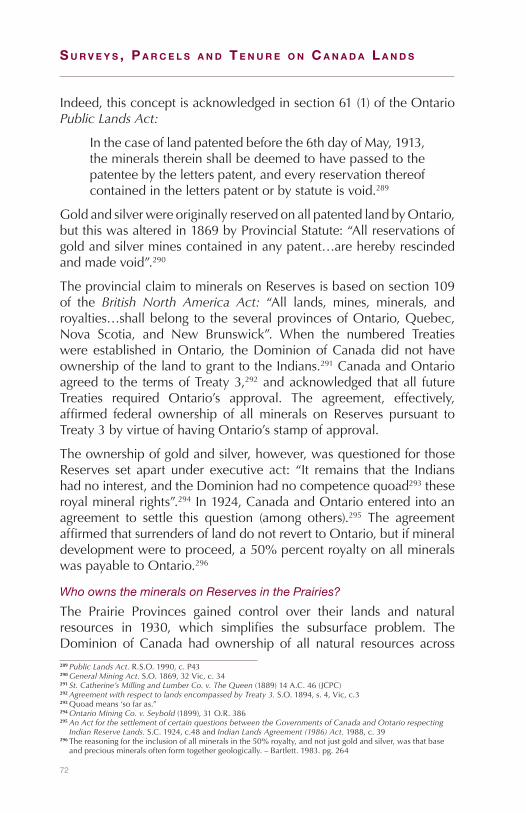
72
S u r v e y S , P a r c e l S a n d T e n u r e o n c a n a d a l a n d S
Indeed,thisconceptisacknowledgedinsection61(1)oftheOntarioPublic Lands Act:
Inthecaseoflandpatentedbeforethe6thdayofMay,1913,themineralsthereinshallbedeemedtohavepassedtothepatenteebytheletterspatent,andeveryreservationthereofcontainedintheletterspatentorbystatuteisvoid.289
GoldandsilverwereoriginallyreservedonallpatentedlandbyOntario,butthiswasalteredin1869byProvincialStatute:“Allreservationsofgoldandsilverminescontainedinanypatent…areherebyrescindedandmadevoid”.290
TheprovincialclaimtomineralsonReservesisbasedonsection109of the British North America Act: “All lands, mines, minerals, androyalties…shallbelong to theseveralprovincesofOntario,Quebec,Nova Scotia, and New Brunswick”. When the numbered Treatieswere established inOntario, theDominionofCanadadidnothaveownershipofthelandtogranttotheIndians.291CanadaandOntarioagreed to the termsofTreaty3,292andacknowledged thatall futureTreaties required Ontario’s approval. The agreement, effectively,affirmed federal ownership of all minerals on Reserves pursuant toTreaty3byvirtueofhavingOntario’sstampofapproval.
Theownershipofgoldandsilver,however,wasquestionedforthoseReserves set apart under executive act: “It remains that the Indianshadnointerest,andtheDominionhadnocompetencequoad293theseroyalmineralrights”.294In1924,CanadaandOntarioenteredintoanagreement to settle this question (among others).295 The agreementaffirmedthatsurrendersoflanddonotreverttoOntario,butifmineraldevelopmentweretoproceed,a50%percentroyaltyonallmineralswaspayabletoOntario.296
Who owns the minerals on Reserves in the Prairies?
The Prairie Provinces gained control over their lands and naturalresources in 1930, which simplifies the subsurface problem. TheDominion of Canada had ownership of all natural resources across289Public Lands Act. R.S.O.1990,c.P43290General Mining Act. S.O.1869,32Vic,c.34291St. Catherine’s Milling and Lumber Co. v. The Queen (1889)14A.C.46(JCPC)292Agreement with respect to lands encompassed by Treaty 3. S.O.1894,s.4,Vic,c.3293Quoadmeans‘sofaras.”294Ontario Mining Co. v. Seybold (1899),31O.R.386295An Act for the settlement of certain questions between the Governments of Canada and Ontario respecting
Indian Reserve Lands. S.C.1924,c.48andIndian Lands Agreement (1986) Act. 1988,c.39296Thereasoningfortheinclusionofallmineralsinthe50%royalty,andnotjustgoldandsilver,wasthatbase
andpreciousmineralsoftenformtogethergeologically.–Bartlett.1983.pg.264

73
Subsurface south of 60 5
Figure26–O
verviewofm
ineralson
PrairieReserves
Num
ber
edTr
eatie
sN
on-T
reat
yIn
dia
n R
eser
ves
Pro
mis
es in
Trea
ty 3
min
utes
Set
asi
de
by
Ord
erin
Cou
ncil
All
min
eral
s
The
pro
mis
es m
ade
in t
heTr
eat
3 m
inut
es a
re t
houg
htto
be
app
licab
le t
o th
enu
mb
ered
tre
atie
s ac
ross
the
Pra
iries
giv
en t
hat
the
wor
din
g in
all
the
num
ber
edtr
eatie
s is
nea
r ve
rbat
im
See
the
Sio
ux In
dia
nR
eser
ves
at O
ak L
ake
and
Bird
tail
Cre
ek in
Man
itob
a,an
d S
tand
ing
Buf
falo
,W
hite
cap
, Wah
pat
on, a
ndW
ood
Mou
ntai
n in
Sas
katc
hew
an
May
var
y p
erd
ocum
ent

74
S u r v e y S , P a r c e l S a n d T e n u r e o n c a n a d a l a n d S
thePrairieswhenitnegotiatedthenumberedTreaties.ThenumberedTreatiesmakenoreferencetomineralsdespitethefactthattheRobinsonTreaties“shapedthecourse”ofthenumberedTreatiesdevelopment.297Treatycommissioners,however,didgiveoralpromisesofmineralstotheFirstNations.298
Additionally, the 1876 Indian Act explicitly defined a Reserve asincluding“allthetrees,wood,timber,soil,stone,minerals,metals,orothervaluablesthereonortherein”.299ThedefinitionremainedintheActthroughrevisionsin1886,1906,and1927,beforebeingalteredtothecurrentdefinitionin1951:“Atractofland,thelegaltitletowhichisvestedinHerMajestythathasbeensetapartbyHerMajestyfortheuseandbenefitofaband”.300ReservesacrossthePrairiesestablishedpursuant to the numbered Treaties prior to 1930 include all basemineralsandallpreciousmetals (goldandsilver),unlessspecificallyexcluded.
After1930,withtheNaturalResourcesTransferAgreements,thewatersgetalittlemuddier.BasemineralsstillpassedtotheReserve,asclause11intheManitobaagreementandclause10intheSaskatchewanandAlbertaagreements stated that futureReservesare “administeredbyCanada in thesameway inall respectsas if theyhadneverpassedto the Province”.301 Preciousmetals, however, passed to the PrairieProvinces in 1930 in a similar manner as to how they passed toOntarioin1867,viasection109oftheBritish North American Act.302 Clause12DoftheManitobaagreementandclause11oftheAlbertaandSaskatchewanagreementsspecificallyapplytheprovisionsofthe1924OntarioAgreement.Thatis, theyallowforReservestoincludebaseminerals, and declared a 50% royalty to the province on anymineralthereon.
It has been argued that the setting aside of Reserves in the PrairieProvinces after 1930 differs from the setting aside of Reserves inOntarioafter1867,andthereforethe50%royaltyisinapplicabletothePrairies.Theargumentisbasedonclause10(Manitoba),andclause11(SaskatchewanandAlberta)ofthetransferagreementsobligatingtheProvincesto:“EnableCanadatofulfillitsobligationsundertheTreaties”.Ontario never had such an obligation. As the numbered Treaties
297Morris.1880.pg.16298Seenotes284and285299Indian Act. S.C.1876,c.18300Indian Act. R.S.1985,c.I-5301Constitution Act, 1930,20-21GeorgeV,c.26(U.K.)302Constitution Act, 1867,30&31Victoria,c.3.(U.K.)

75
Subsurface south of 60 5
promisedallresources,bothpreciousandbase,totheFirstNations,BartlettarguesthatthePrairieProvincesmightbeobligatedtotransfertheseinterestswiththelandtofulfillthetermsoftheagreement.303
This obligation was recognized in Saskatchewan where it isacknowledgedthatmineralscanbetransferredfromProvincialCrowntoFederalCrown“forthepurposeofassistingHerMajestytheQueenin rightofCanada to satisfyordischargeanyobligations…to IndianbandsinSaskatchewan”.304TheinapplicabilityoftheOntarioprovisionis furtherbolsteredbySaskatchewan’s1976declarationthat“itdoesnot agree to renounce any rights it has to one-half royalties…butdoesnotassert that right”.305 Likewise,Manitobahasnever formallyrenouncedtheright,buthasnevermadeaclaimeither.306Additionally,bothSaskatchewanandManitobarelinquishedanyclaimstoroyaltiesundertheTreatyLandEntitlementagreementsinthe1990s.307
Thesituationacross thePrairies isnotwithoutexception.TheSiouxwhofledfromtheUnitedStatesandtookupresidenceinManitobaandSaskatchewanwerenotparty to anyof thenumberedTreaties.Reserveswere created byOrders-in-Council in the areas the Siouxhadsettled.308TheestablishmentoftheSiouxReserveswasnotedtobe “amatter of grace and not of right”,309 so the extent ofmineralpossessionisdependantontheoriginalOrder-in-Council(OIC)whichsettheReservesaside.
Who owns the minerals on Reserves in British Columbia?
Prior to Confederation there existed several Reserves in BritishColumbia.310 These comprised those Reserves made up of “villagesites”and“enclosedfields”setasidebytheDouglasTreaties(1850s)onVancouver Islandand thosereservescreatedpursuant tosurveysbycolonialofficials.311GovernorDouglascommentedthat“theareasthuspartiallydefinedandsetapart…are tobeheldas the jointandcommonpropertyofseveraltribes,beingintendedfortheirexclusiveuseandbenefit”.312
303Bartlett.IndianReservesonthePrairies.Alberta Law Review.243.1985304Crown Minerals Act. 1985, C-50.2,Sec.3(4)(C)305Bowerman.LettertoChiefAhenakew,August23,1976–asquotedinBartlettpg.262306ManitobaAboriginalJusticeImplementationCommission.FirstQuarterlyReport.March31,2000307See-section11.05ManitobaTLEFrameworkAgreement,signedMay29,1997;pg3oftheSaskatchewan
NaturalResourcesTransferAgreement(TLE)Act,effectiveJune22,1993308SeeReservesatOakLakeandBirdtailCreekinManitoba,andStandingBuffalo,Wahpaton,Whitecap,and
WoodMountaininSaskatchewan.309Morris.1880.pg.279310Cail.Land, Man, and the Law: The disposal of Crown Lands in British Columbia. UBC.1974311Papers Connected with the Indian Lands Question 1850-75 – Conveyance of Land to Hudson’s Bay Company
by Indian Tribes. ArchivesofCanada.1850.312B.C.LegislativeCouncil.Journals. 1rstParliament.1864
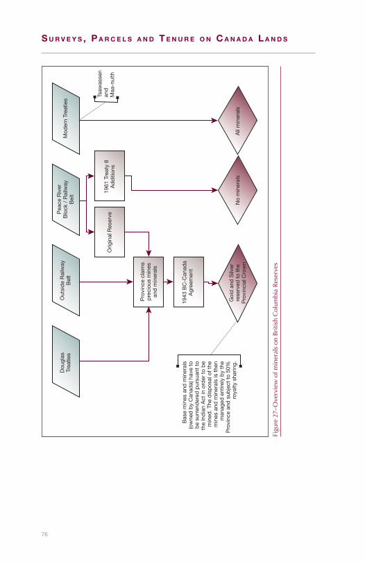
76
S u r v e y S , P a r c e l S a n d T e n u r e o n c a n a d a l a n d S
Figure27–Overviewofm
ineralson
BritishColum
biaReserves
Dou
glas
Trea
ties
Out
sid
e R
ailw
ayB
elt
Pea
ce R
iver
Blo
ck /
Rai
lway
Bel
tM
oder
n Tr
eatie
s
Orig
inal
Res
erve
1961
Tre
aty
8A
dd
ition
s
Tsaw
asse
nan
dM
aa-n
ulth
Pro
vinc
e cl
aim
sp
reci
ous
min
esan
d m
iner
als
Bas
e m
ines
and
min
eral
s(o
wne
d b
y C
anad
a) h
ave
tob
e su
rren
der
ed p
ursu
ant
toth
e In
dia
n A
ct in
ord
er t
o b
em
ined
. The
dis
pos
al o
f the
min
es a
nd m
iner
als
is t
hen
man
aged
ent
irely
by
the
Pro
vinc
e an
d s
ubje
ct t
o 50
%ro
yalty
sha
ring.
1943
BC
-Can
ada
Agr
eem
ent
Gol
d a
nd S
ilver
rese
rved
to
the
Pro
vinc
ial C
row
nN
o m
iner
als
All
min
eral
s
77
Subsurface south of 60 5
WhenBritishColumbiaenteredConfederationin1871itwassubjecttoArticle13oftheTermsofUnion,whichrequired“tractsofland…conveyedbytheLocalGovernmenttotheDominionGovernmentintrustfortheuseandbenefitoftheIndians”.TheProvincialrequirementto convey “tracts of land” is normally construed to include baseminerals.313 Gold and silver are generally reserved to the Provinceexceptwhereexplicitlygranted;theycouldalsobecededwherethegrant“contemplatedthecessionbytheProvinceofallitsinterestsintheland,royalaswellasterritorialtotheDominionGovernment”.314
Itwasnotuntil1938,however,thatBCconveyedmostReservestothefederalgovernment.315Therewasnomentionofany reservationsofmineralsinthe1938OrderinCouncil.TheotherreservationsintheOIC(1/20thof landforpublicworks,water foradjacentminingandagriculture,constructionmaterials,andexistinghighways)areverbatimfrom the forms ofCrown grants under theCrown Lands Act,316 buttheclauseto“raiseandgetminerals,preciousorbase”wasremoved.Thisindicatesthatbasemineralswereexplicitlycontemplated,andarethus included in theReserves transferred toCanada in1938.317ThissituationencompassesnearlyallReservesinBritishColumbia,withtheexceptionofthoseonVancouverIslandcoveredbytheaforementionedDouglasTreatiesandcolonialsurveys,thosepurchasedinfeesimple,andthosecoveredbytheRailwayBeltandPeaceRiverBlock.
As part of the Terms ofUnion in 1871, BritishColumbia agreed toconvey a 40 mile swath along the proposed railway line to theDominiongovernment. In1884,BritishColumbiaagreed to transfer3.5millionacres toCanada for railwaypurposes in thePeaceRiverDistrict.318Manyof theFirstNationsof theareasignedanadhesiontoTreaty8withCanada.ThenumberedTreatiesincludedbothbaseandpreciousminerals.Thenatureofthe1871and1884agreementswithCanada, however, did not result in the ceding of the preciousminerals.319ThereforeCanadacouldnothavegrantedthempursuanttoanyReserveintheRailwayBeltorintheTreaty8adhesion.
In1930,theRailwayBeltandthePeaceRiverblockweretransferredback toBC,with theReserves removed.320Baseminerals shouldbe313Bartlett.Resource Development on Indian Reserve Land. inSaunders.ManagingNaturalResourcesina
FederalState.Papers Presented at the second Banff Conference on Natural Resources Law. 1985314Attorney General of British Columbia v. Attorney General of Canada.(1889),14A.C.295315ProvincialOrderinCouncil1938-1036316Crown Lands Act, R.S.B.C.1924,Forms9,11–Bartlett.1985.pg.198317Bartlett.1985.pg.198318Act relating to the Island Railway, the Graving Dock and Railway Lands of the Province. 1884,c.14319Bartlett.1985.pg.196320Constitution Act, 1930,Schedule(4)

78
S u r v e y S , P a r c e l S a n d T e n u r e o n c a n a d a l a n d S
consideredpartof theReservesestablishedin theRailwayBelt,andthePeaceRiverBlock,asCanadaheldownershipofthebasemineralswhen theReserveswerecreated. In1961, to fulfill theprovisionsofTreaty 8, British Columbia conveyed an additional 24,448 acres toCanadabutreservedallminerals.321
Canada and British Columbia entered into an agreement in 1943regarding the development of minerals on all Reserves.322 Thedispositionofmostmineralscameundertheadministrationandcontrolof theProvince(coal,oil,gas,andafewothersarenot included323).TheProvincialcontrolofmineralsonReserves isconditionalonthebaseminerals being surrendered pursuant to the Indian Act. Uponsuchsurrender,andwithanymineraldevelopment,“one-halfofalltherevenuecollected…shallbelong to theProvinceofBritishColumbiaandone-half…totheReceiverGeneralofCanada”.TheProvincehadclaimedallgoldandsilverunderlyingReserves,whichclaimjustifiedthe agreement: the “development of all the minerals…is presentlyimpracticalsincethepreciousandbasemetalsarecloselyassociatedandcannotbeminedseparately”.Theagreementwasfurtherextendedto includeallcoal,oil,andgas rights in theFortNelsonReserve in1977.324
ModerndayTreatiesaffirmtheFirstNationinterestinminerals.In1998,theNisga’aNationwasrecognizedasowningall“mineralresourcesonorunderNisga’aLands”,definedtoincludeallminerals(includinggold and silver).325 In 2007, the agreement with the TsawwassenFirstNationconfirmedtheFirstNationownershipofallthemineralsunderlying their lands (exceptingEnglishBluff), forwhich theyweregiven$2millionincompensation.326TheMaa-nulthFirstNationalsoownsthemineralrights,pursuanttotheirfinalagreementin2006.327
Who manages mineral rights and under what authority?
MineralrightsonReservesareadministeredbyIndianandNorthernAffairsCanada(INAC),withthreeexceptions.InQuebecandPrinceEdward Island, no agreements were ever reached with Canadaregarding disposal of minerals on Indian Reserves, and in British
321ProvincialOrderinCouncil1961-2995322British Columbia Indian Reserves Mineral Resources Act, 1943-44. R.S.C.,c.19323Notincludedare:“peat,coal,petroleum,naturalgas,bitumen,oilshales,limestone,marble,clay,gypsum,
oranybuildingstonewhenminedforbuildingpurposes,earth,ash,marl,gravel,sandoranyelementwhichformspartoftheagriculturalsurfaceoftheland”
324Fort Nelson Indian Reserve Minerals Revenue Sharing Act. 1980-81-82-83,c.38325Nisga’a Final Agreement,1998326Tsawwassen First Nation Final Agreement,2007327Maa-nulth First Nations Final Agreement, 2006
79
Subsurface south of 60 5
ColumbiaanagreementwithCanadasubjectsmineralsonReservesto Provincial legislative control. In all other jurisdictions the federalgovernmentmanages themineral rights on IndianReserves and theIndian Mining Regulations328providetheframework.
What rights are granted for mineral development?
AFirstNationmustsurrender,ordesignate,toCanadarightstomineralsunderlyingaReserve,ifdevelopmentistotakeplace.329Theelectivesurrenderprocesswasestablishedasafunctionoftheinterpretationof Aboriginal title in Canada, in that: “…aboriginal title precludesalienationofthereservelandbaseofthebandwithoutconsentofthebandmembers”.330Formineraldevelopment,though,thesurrenderisconsideredtobeconditional,inthatthemineralscontinuetobe“landsreservedforIndians”,331andundertheexclusivelegislativejurisdictionofthefederalgovernment.
Onceasurrenderhasbeenaccepted,twotypesofrightscanbegrantedpursuanttotheIndian Mining Regulations:1)permitsand2)leases.Apermitgrantstherighttoexploreformineralswithinaspecifiedarea.Apermitdoesnotconveytherightstothemineralsfoundintheland,andisissuedfornomorethanoneyearwithprovisionsforextensions.Alease,issuedpursuanttotheregulations,grantstherighttoexplore,develop, and produce minerals within the lease area. Leases aretypicallyfora10-yearperiod,withaprovisionforrenewal.
Where are mineral rights registered?
Documents granting mineral interests are registered in the IndianLandsRegistry.AsearchoftheRegistryshowsthatover1800mineralrelatedpermits,leasesand/oragreementshavebeenrecorded.Abouthalfarestillactive.332
What surveys are required for mineral development?
UnderSections21and22oftheIndian Mining Regulations, ifasurveyis deemed necessary by INAC, the Surveyor General issues surveyinstructionstoacommissionedlandsurveyortosurveytheboundariesofproposedorexistingleasesites.Inpractice,fewsurveysaredone
328Indian Mining Regulations. C.R.C.,c.956329Indian Act,R.S.,1985,c.I-5-Sections37to39,and93.330Bartlett.IndianActofCanada.Buffalo Law Review. 27(581).1978331The Constitution Act, 1982,s.91(24)332BasedonInstrumentReportsfromtheIndianLandRegistrySystem(ILRS)constrainedto:Instrumenttype=
‘PermitorLease’,andPurpose=‘Minerals’
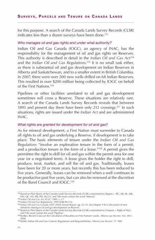
80
S u r v e y S , P a r c e l S a n d T e n u r e o n c a n a d a l a n d S
forthispurpose.AsearchoftheCanadaLandsSurveyRecords(CLSR)indicateslessthanadozensurveyshavebeendone.333
Who manages oil and gas rights and under what authority?
Indian Oil and Gas Canada (IOGC), an agency of INAC, has theresponsibility for themanagementofoilandgas rightsonReserves.Thisauthorityisdescribedindetailinthe Indian Oil and Gas Act334 and the Indian Oil and Gas Regulations.335 It isnosmall taskeither,asthereissubstantialoilandgasdevelopmentonIndianReservesinAlbertaandSaskatchewan,andtoasmallerextentinBritishColumbia.In2007,therewereover200newwellsdrilledon68IndianReserves.Thisresultedinover$200millionbeingcollectedbyIOGConbehalfoftheFirstNations.336
Pipelines or other facilities unrelated to oil and gas developmentsometimeswill cross a Reserve. These situations are relatively rare.Asearchof theCanadaLandsSurveyRecords reveals thatbetween1893andpresentdaytherehavebeenonly212crossings.337Insuchsituations,rightsareissuedundertheIndian ActandareadministeredINAC.
What rights are granted for development for oil and gas?
Asformineraldevelopment,aFirstNationmustsurrendertoCanadaallrightstooilandgasunderlyingaReserve,ifdevelopmentistotakeplace. The basic elements of tenure under the Indian Oil and Gas Regulations “involve an exploration tenure in the form of a permit,andaproductiontenureintheformofalease.”338Apermitgivesthepermitteetherighttodrillforoilandgaswithinthepermitareaforoneyear(oranegotiatedterm).Aleasegivestheholdertherighttodrill,produce, treat,market,andsell theoilandgas.Traditionally, leaseshavebeenfor20ormoreyears,butrecentlythishasbeenreducedtofiveyears.Generally,leasescanberenewedwhenawellcontinuestobeproductivepastfiveyears,butcanalsoberenewedatthediscretionoftheBandCouncilandIOGC.339
333BasedonPlanQueryoftheCanadaLandsSurveysRecords(CLSR)constrainedto:Region=‘BC,AB,SK,MB,ON,QC,NS,NB,PEI,NL/LA’,andTitlemustcontaintheword‘Mineral’.
334Indian Oil and Gas Act, R.S.C,1985,c.I-7335Indian Oil and Gas Regulations, 1995SOR/94-753336Indian Oil and Gas Canada 2007–2008 Annual Report. pg.22–23.Seechapter4foradiscussionofnew
initiativesrelatingtooilandgasdevelopmentonReserve.337BasedonPlanQueryoftheCanadaLandsSurveysRecords(CLSR)constrainedto:Purpose=‘RightofWay’,
andTitlemustcontaintheword‘Pipeline’.338Bankes.RecentCasesontheCalculationofRoyaltiesonFirstNations’Lands.Alberta Law Review. Vol.38(1).
2000339Webb.IndianOilandGas:Control,RegulationsandResponsibilities.Alberta Law Review. 77.1987
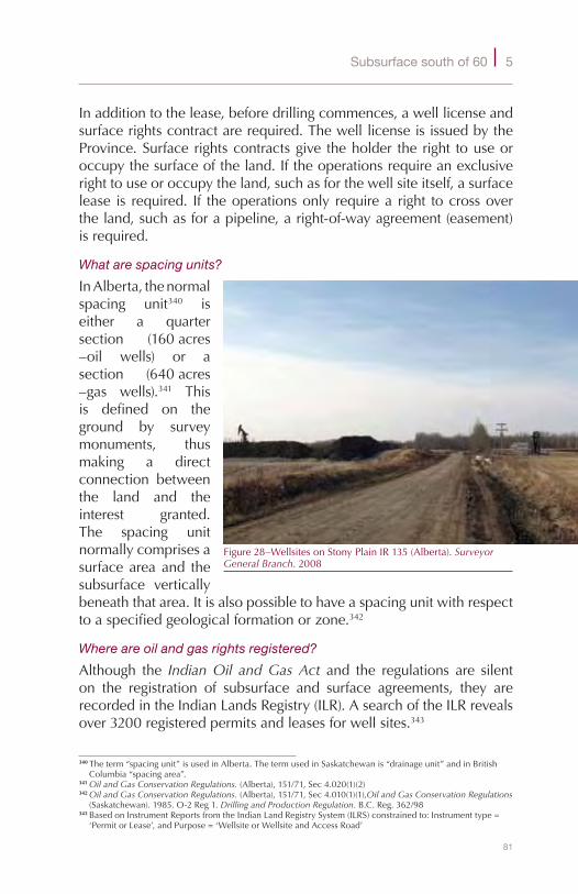
81
Subsurface south of 60 5
Inadditiontothelease,beforedrillingcommences,awelllicenseandsurfacerightscontractarerequired.ThewelllicenseisissuedbytheProvince.Surfacerightscontractsgive theholder theright touseoroccupythesurfaceoftheland.Iftheoperationsrequireanexclusiverighttouseoroccupytheland,suchasforthewellsiteitself,asurfacelease is required. If theoperationsonly requirea right tocrossovertheland,suchasforapipeline,aright-of-wayagreement(easement)isrequired.
What are spacing units?
InAlberta,thenormalspacing unit340 iseither a quartersection (160acres–oil wells) or asection (640acres–gas wells).341 Thisis defined on theground by surveymonuments, thusmaking a directconnection betweenthe land and theinterest granted.The spacing unitnormallycomprisesasurfaceareaand thesubsurface verticallybeneaththatarea.Itisalsopossibletohaveaspacingunitwithrespecttoaspecifiedgeologicalformationorzone.342
Where are oil and gas rights registered?
Although the Indian Oil and Gas Act and the regulations are silenton the registration of subsurface and surface agreements, they arerecordedintheIndianLandsRegistry(ILR).AsearchoftheILRrevealsover3200registeredpermitsandleasesforwellsites.343
340Theterm“spacingunit”isusedinAlberta.ThetermusedinSaskatchewanis“drainageunit”andinBritishColumbia“spacingarea”.
341Oil and Gas Conservation Regulations. (Alberta),151/71,Sec4.020(1)(2)342Oil and Gas Conservation Regulations. (Alberta),151/71,Sec4.010(1)(1),Oil and Gas Conservation Regulations
(Saskatchewan).1985.O-2Reg1.Drilling and Production Regulation. B.C.Reg.362/98343BasedonInstrumentReportsfromtheIndianLandRegistrySystem(ILRS)constrainedto:Instrumenttype=
‘PermitorLease’,andPurpose=‘WellsiteorWellsiteandAccessRoad’
Figure28–WellsitesonStonyPlainIR135(Alberta).Surveyor General Branch.2008

82
S u r v e y S , P a r c e l S a n d T e n u r e o n c a n a d a l a n d S
What surveys are required for oil and gas?
Surveysarerequiredforsurfacerights.GeneralsurveyinstructionsareissuedbytheSurveyorGeneral,andplansarerecordedintheCLSR.344Therearealsoprovisionsforasurveytobemadeifadisputearisesregardingthelocationofawell,facilityorboundary.345AreviewoftheCLSRindicatesover4200registeredwellsitesurveyplans.346SurveysforoilgasmustbeperformedbyaCanadaLandSurveyor(CLS),whoalso holds the relevant provincial land surveying commission. Thereasoning for thedualcommission is two fold:1) theCanada Lands Surveys Act stipulatesthatonlyaCLScansurveyonCanadaLands,3472)ProvincialoilandgasregulationsrequiresurveysbyProvincialLandsSurveyors.348
Who owns the minerals on National Parks?
Canadaholds title to theunderlyingminerals.TheCanada National Parks Act349 requires that Canada have clear title to lands to beincludedinaNationalPark.Historically,mininghasbeenallowedinNationalParks.TheBankheadmineinBanffNationalParkwasstillinoperationaslateas1922.350Now,however,explicitpermissionfromParksCanadaisrequiredfortheremovalofany“naturalobject”.351
So, what’s the bottom line?
Asisreadilyapparentfromtheforegoingdiscussion,subsurfacerightsare very complex, and surveyors are well-advised to marry theiropinionsontheparcel’sspatialextentwithexternallegalanalysisandadvice.Thischapterismerelyanintroductiontotheissues;eachfactsituationmustbeassessedonitsownmerits.
344NRCAN. General Instructions for Surveys of Canada Lands, e-Edition. 2008345Indian Oil and Gas Regulations. 1995SOR/94-753,Sec.40(2)346BasedonPlanQueryoftheCanadaLandsSurveysRecords(CLSR)constrainedto:Index=‘CLSR’andType=
‘OilandGasWellsandFacilities’347Canada Lands Surveys Act. R.S.,1985,c.L-6,s.26(1)348Oil and Gas Conservation Regulations. (Alberta),Sec3.1(C);Oil and Gas Conservation Regulations.
(Saskatchewan),Sec.10(a)(ii)349Canada National Parks Act. 2000,c.32,s.5(1)(a).350Gadd.Bankhead: The Twenty Year Town. CoalAssociationofCanada.1989351Naturalobjectisdefinedas“anynaturalmaterial,soil,sand,gravel,rock,mineral,fossilorotherobjectof
naturalphenomenon”.National Parks General Regulations,SOR/78-213

83
6National Parks
Who manages lands in the national parks?
TheParksCanadaAgency(hereinafterParksCanada),establishedbytheParks Canada Agency Act,352isresponsiblefortheimplementationof policies of the federal Crown that relate to natural or historicalsignificance.Withregardtonationalparks,ParksCanadaensuresthattherearelong-termplansinplaceforestablishingsystemsofnationalparks and is responsible for negotiating, and recommending to theMinister of Environment, the establishment of new national parks.Aswell, it is responsible for the administration and enforcement oflegislation dealing with areas of natural or historical significance,includingtheCanada National Parks Act.353
The Realty Services Section, Infrastructure and Real PropertyDirectorateofParksCanada(locatedinGatineau,Quebec)hasoverallresponsibility forpolicyand regulationof realtyactivity.Day todayrealtyoperations are carriedout by staff in the four service centres(Atlantic,Quebec,OntarioandWestern)andinseveralfieldunits.
When was the first national park in Canada established?
In 1885, some 10 square miles which included the hot springs atBanff were reserved “from sale, settlement or squatting”.354 TwoyearslatertheRocky Mountains Park Act,1887355establishedaparkof 260squaremiles, which enclosed the 10 square miles originallysetaside in1885.TheparkeventuallybecameBanffNationalPark.352S.C.1998,c.31.353S.C.2000,c32.3541885P.C.2197.355S.C.1887,c.32.

84
S u r v e y S , P a r c e l S a n d T e n u r e o n c a n a d a l a n d S
Figure29–M
apsho
winglocatio
nsofN
ationalP
arks.S
urve
yor
Gen
eral
Bra
nch.2010

85
National Parks 6
What was the first piece of legislation that applied to national parks?
The Dominion Forest Reserves and Parks Act356 1911 was a dualpurposeact in that itprovided forDominion forest reservesand forDominion parks. TheGovernor in Council could, by proclamation,designate Dominion parks from lands comprising Dominion forestreserves.LessthanamonthaftertheActwaspassed,Glacier,Yoho,Rocky Mountains, Jasper and Waterton Lakes were established asDominionparks.357
ItwassoonrealizedthatitwasalsodesirabletosetasideareasoutsideofDominion forest reservesasDominionparks.358 Laterparkswerealso established in the central and eastern provinces, including theSt.LawrenceIslandsNationalParkwhichislocatedintheThousandIslands.In1904nineislandsweretransferredfromtheadministrationand control of the Superintendent General of Indian Affairs to theMinisteroftheInteriorforparkpurposes.The$9,150paidfortheislandswas credited to the Mississauga Band of Alnwick. Later additionalislandswereacquiredandallof thesewereeventually incorporatedintotheSt.LawrenceIslandsNationalPark.359
What was the significance of the 1930 National Parks Act?
The National Parks Act360wasimportantasitprovidednationalparkswithitsownlegislation. It removedtheadministrationofparks fromthe authority of the Dominion Forest Reserves and Parks Act anddesignatedtheparksasnationalparksofCanada.The1930legislationcoincidedwiththeConstitution Act, 1930 whichconfirmedthenaturalresourcetransferagreementswiththeWesternprovinces.UndertheConstitution Act, 1930nationalparkswouldcontinuetobevestedinandadministeredbyCanada.
How are national parks established?
ParksCanadapolicyistoestablishnewnationalparksinaccordancewith a national parks system plan. The plan divides Canada into39distinct natural regionswith theobjectiveof having at least onenationalparkineachregion.361
356S.C.1911,c.10.357June8,1911referredtoinLothian.A History of Canada’s National Parks, Volume II,1977,p.12.358An Act to amend The Dominion Forest Reserves and Parks Act,S.C.1913,c.18,s.4.Section4amendeds.18of
The Dominion Forest Reserves and Parks Act,S.C.1911,c.10.359Lothian.A History of Canada’s National Parks, Volume I,1976,pp.82–83.360S.C.1930,c.33.361ParksCanadaGuidingPrincipleandOperationalPolicies(DateModified2009-04-15)PartII,NationalParks
Policy,Section1.

86
S u r v e y S , P a r c e l S a n d T e n u r e o n c a n a d a l a n d S
How is the National Parks Act amended to establish new national parks?
A national park may be established by adding the name and adescriptionof thepark toSchedule1of theCanada National Parks Actbyorder-in-council.Similarlyanationalparkmaybeenlargedbyamendingthedescriptionof theparkinSchedule1.TwoconditionsarethatthefederalCrownhascleartitletooranunencumberedrightofownershipinthelandstobeincludedinthepark,andtheprovincialCrownhasagreedtotheiruseforapark.
What are national park reserves?
There isprovision in theCanada National Parks Act forestablishingnational park reserveswhere lands proposed for national parks aresubjecttoaclaiminrespectofaboriginalrightsthathasbeenacceptedfornegotiationbytheGovernmentofCanada.362TheCanada National Parks Actappliestoaparkreserveasifitwereapark.363Parkreserveshavethusbeensurveyedasiftheywereparks.
Park reserves are listed in Schedule2 of the Act. The name anddescription of the park reserve may be removed from Schedule2andaddedtoSchedule1byorder-in-counciloncealllandclaimsaresettledandthefederalCrownhascleartitletooranunencumberedrightofownershipinthelands.364
Can land be removed from national parks?
Landcanberemovedinonlytwoways.EitheracourtfindsthatCanadadoesnothavecleartitleto,oranunencumberedrightof,ownershipinlandswithinthepark;365ortheCanada National Parks Actisamended.
How is land use activity managed?
Activityiscontrolledbyazoningsysteminordertoprotectnationalparklands.Therearefivezones:
◆ I SpecialPreservation:areasorfeaturesthatdeservespecialpreservation.
◆ II Wilderness:areasthataretobeconservedinawildernessstate.
◆ III NaturalEnvironment:areasforoutdoorrecreationactivitieswithveryminimumservicesandifvehicleaccessisalloweditiscontrolledorlimited.
362Canada National Parks Act,S.C.2000,c.32,s.4(2).363Canada National Parks Act,S.C.2000,c.32,s.39364ParksCanadaGuidingPrinciplesandOperationalPolicies,PartII,NationalParksPolicy,Sections1.4and1.5.365Canada National Parks Act,S.C.2000,c.32,s.6(2)

87
National Parks 6
◆ IV OutdoorRecreation:areasthatcanbeaccessedbyprivatevehicle, while still limiting environmental impact to thesmallestextentpossible.
◆ V ParkServices:communitiesinexistingnationalparkswhichcontain a concentration of visitor services and supportfacilities.
Parks Service com-munities include na-tional parks towns,visitor centres andresortsubdivisions.366Parks Canada hasestablished limit sto growth in ParksCanada commun-ities but there is stillconsiderable existingbusinessandresiden-tial tenure in ParksServicecommunities.On January 1, 1990,the Town of Banffwas incorporated asa townwithmunici-paltaxing,utilityandplanningauthority.367TheTownofJasperbecameanAlbertamunicipalityonJuly20,2001withmunicipaltaxationandutilityauthority.PlanningforJasperwasretainedbyParksCanada.368Thedesignationvisitorcentre isgiven tonationalparkcommunitiesthatprovideafocusforandconcentrationofvisitoractivity,servicesandfacilities.WatertoninWatertonLakesNationalPark,WasagaminginRidingMountainNationalPark,WaskesiuinPrinceAlbertNationalParkandLakeLouiseinBanffNationalParkarevisitorcentres.Field- inYohoNationalPark- isa largely residentialcommunityaccom-modatingtheadministrativecentrefortheparkwithsomecommercialservicessuchasahotel,hostels,restaurants,retailandavisitorinfor-mationcenter.Also,resortsubdivisionswereestablishedearlyinthe
366ParksCanadaGuidingPrincipleandOperationalPolicies(DateModified2009-04-15)PartII,NationalParksPolicy,Section2.2.AlsoseeNational Parks of Canada Wilderness Area Declaration Regulations,SOR/2000-387andNational Parks Town, Visitor Centre and Resort Subdivision Designation RegulationsSOR/91-8.
367TheGovernmentofCanadaandtheGovernmentofAlberta,TownofBanffIncorporationAgreement.368AlbertaOrder-in-Council#279/2001.
Figure30–CrossingtheSaskatchewanRiver,BanffNationalPark(Alberta).Library and Archives Canada/PA-023174.1935

88
S u r v e y S , P a r c e l S a n d T e n u r e o n c a n a d a l a n d S
historyofsomeparkssuchasJasper,WoodBuffalo,PrinceAlbertandRidingMountain.369
Developmentofadditionallandsisnotallowedfornewcommunities,private cottages, camps or seasonal camping areas or for new, orexpansionofexisting,golfcoursesorskiareasunderprovisionsintheCanada National Parks Act.370
How has land tenure evolved?
The Rocky Mountains Park Act,1887hadprovi-sionfortheestablishmentof regulations for leasingof land. After initial at-tempts by the Depart-ment of the Interior toissueleasesforamere21yearswereobjectedtobycitizensofBanff,termsofleases of 42 years withcovenants for perpet-ual renewalsweremadeavailable in 1890.371 Thegranting of these leases,calledperpetualleases,werediscontinuedintheearly1960’s,372how-evermanyarestillinexistenceinBanffandJasperandinseveralothernationalparksinWesternCanada.373
The perpetual renewal provisions were tested in the 1960’s whenCanada attempted to substitute new leases without the right ofperpetualrenewal.However,theSupremecourtofCanadaheldthatCanadarenewtheexistingleasesbyhonouringtherightofperpetualrenewal.374Under currentpolicy, tenuremaybegranted innationalparklandsintheformofleases,licencesofoccupationorpermitsfor
369ParksCanadaGuidingPrincipleandOperationalPolicies(Modified2009-04-15),PartII,NationalParksPolicy,Sections5.1.
370R.S.A.2000,c.C-22,ss.16(4)&36(1).371Lothian.1977.pp.56–57.372Lothian.1977.p.64.373Thetotalnumberofperpetualleasesin1985was;Banff:631,inJasper:335,inWaterton:128,inYoho:23,in
PrinceAlbert:84andinRidingMountain:248.Statisticsprovidedin1988byE.Desrochers,Registrar,ParksCanada.
374The Queen v. Walker,[1970]S.C.R.649.
Figure31–SurveyoftheNorthboundaryofYohoNationalPark(BC).Surveyor General Branch.1955

89
National Parks 6
theprovisionofessentialservicesandfacilitiesforparkvisitorsandforauthorizedresidentialuses.375
What of leases and surveys for leases?
UndertheNational Parks of Canada Lease and Licence of Occupation Regulations376theMinistermaygrantaleaseforanyperiodoftimenotexceeding42years.Theleasemayalsocontainprovisionforrenewalhowevertherearerestrictionswithregardtotheterm.Therearealsorestrictionswhichdependonthepurposeoftheleaseandthelocationofthelandleased.LeasesmaybegrantedforresidentialpurposesinthetownsofBanffandJasper,invisitorcentresandinresortsubdivisions.Theyarealsoissuedforessentialservicesandfacilitiesforparkvisitorswithinthenationalparks.
Survey requirements for leases are specified in Section3(2) of the Regulations.Noleaseofpubliclandsshallbegranted:
(a)untilthepubliclandshavebeensurveyedinaccordancewiththeCanada Lands Surveys Actandunlessthedescriptionofthe lands in the lease is based on an official plan or plansunderthatAct;or
(b)unless,wheretheMinistersodirects,theleasedescribesthepubliclandsby(i) referencetoanexplanatoryplanapprovedbyandinthe
custodyoftheSurveyorGeneral,or(ii) ametesandboundsdescription,ortheequivalentthereof,
prepared under the direction of and approved by theSurveyorGeneral.
TheonlynationalparksinwhichcondominiumsarerecognizedintheNational Parks of Canada Lease and Licence of Occupation RegulationsareinAlberta.CondominiumplansareregisteredintheAlbertaLandTitles Office.377 Parks Canada issues one lease (commonly calledtheheadlease)fortheentirecondominiumdevelopmenttothenewleaseholdowner,normallyadeveloper.Afterthecondominiumsurveyplanisregisteredandtitleopenedforeachunittheleaseholdowner(developer) will issue assignments to purchasers of individual units.AftertheseassignmentsareregisteredintheLandTitlesOffices(withconsentfromtheMinister),leaseholdtitletoindividualunitsmaybetransferredtotheunitpurchasers.378375ParksCanadaGuidingPrincipleandOperationalPolicies(Modified2009-04-15),PartII,NationalParks
Policy,Sections6.1.1.376SOR/92-25,P.C.1991-2469.Leases:s.3to17.377Section87oftheAlbertaLand Titles ActR.S.A.2000,c.L-4.378Pralow,Dianne.ParksCanada,2006.

90
S u r v e y S , P a r c e l S a n d T e n u r e o n c a n a d a l a n d S
ForthepurposeofsurveyingcondominiumsubdivisionsinAlberta,theAlbertaCondominium Property Act379isusedinsofarasitcanapplyforleaseholdinterestsinnationalparksinAlberta.InadditionPartD4of the General Instructions for Survey (of the Surveyor General ofCanada)e-Editionhasinstructionsforcondominiumsurveys.
What of licences of occupation and permits?
UnderSection18(1)oftheNational Parks of Canada Lease and Licence of Occupation Regulations, the Minister may grant licences ofoccupationforanyperiodof timenotexceeding42years.Theyareissuedforaspecificpurposeanddonotgivethelicenseeanyleaseholdestateorotherestateorinterestinland.
They are gener-ally used for suchpurposes as admin-istrative space inbuildings or in areasoutside of townsand visitor centresfor purposes suchas visitor accommo-dations, trails, cor-rals and alpine hutswhere land conflictsareunlikely tooccurandwhere exclusiveuseofthelandisnotrequired. Surveysare not normally re-quiredforlicencesof
occupation. The land is usually describedby sketch, site planor inremoteareasreferencetoatopographicmap.
Under the National Parks General Regulations380 permits may begrantedforavarietyofactivitiesinnationalparksrangingfromcampingtotheuseofwater.Surveysarenotrequiredforpermits.
What of rights-of-way for public purposes?
There isprovisionunderSection15(1)of theCanada National Parks ActfortheMinistertoenterintoleasesof,andeasementsorservitudes379R.S.A.2000,c.C-22.380SOR/78-213.
Figure32–MarkingtheAlberta-BCboundaryinBanffNationalPark.Surveyor General Branch.1968

91
National Parks 6
over,publiclandsinaparkthatareusedforrights-of-wayofexistingrailway lines, oil and gas pipelines, telecommunication or electricaltransmissionlinesandforrelatedfacilities.ThelandsremainpartoftheparkandiftheyceasetobeusedforthepurposeintendedtherightorinterestrevertstotheCrown.
As a general rule,r ight s - of-way forpub l i c pu r po s e sunder Section 15(1)require a survey inaccordance with theCanada Lands Sur-veys Act. In somesituationsanexplana-tory plan approvedby and held in thecustody of the Sur-veyor General or, atthe discretion of theSurveyor General, ametes and boundsdescription or theequivalent may beusedtodescribethelands.381
Where can land interest information be obtained?
Thereisnolegislationspecificallyrequiringalandregistrationsystemfornationalparks.Neverthelessasystemreferredtoasalandregistryhasbeeninplacesincethefirstfederalnationalparkwascreated.ThelandregistrylocatedinGatineau,Quebecconsistsofhardcopyandelectronic records of all acquisitions, disposals and alienation of allParksCanadalands.382Itcontainsoriginaldocumentssuchasorders-in-council,landtransferagreements,saleagreements,leases,licences,land use agreements and related correspondence. Copies of somedocumentsmayalsobeavailablefromservicecentresandfieldunits.
381ChapterB1-1-InterdepartmentalAgreementreDescriptionofCanadaLands,1955(ExcludingIndianLands),GeneralInstructionsforSurveys,e-Edition:SurveyorGeneralsBranch(SGB)Website.AccessedOct.8,2010.
382Marlow,Lorrie.ParksCanada,December21,2009.
Figure33–SurveyinginGulfIslandsNationalPark(BC).Surveyor General Branch.2005

92
S u r v e y S , P a r c e l S a n d T e n u r e o n c a n a d a l a n d S
What is unique about national parks land interests in Alberta?
Asearlyas1890,copiesofexecutedleasesweresentbytheDepartmentofInteriortotheLandTitlesOfficeinCalgary.TheRegistrarrecordedtheleaseandissuedacertificateoftitletothelessee.383Albertaistheonlyprovince inCanadawhere leasesof land innationalparksareregisteredinaprovinciallandregistrationsystem.Purchasersarrangetohavetheirassignments,mortgagesandleasesregistered.Certainly,lendinginstitutionsrequireit.CurrentlynearlyallleasesinthetownsofBanffandJasperandinthevisitorcentreofWatertonareregisteredintheprovinciallandtitlessystem.384
What of internal parcel fabric?
UnderSection33oftheCLSActconfirmed plansofresurveyaretobesubstitutedfortheformerofficialplansofthelandaffectedundertheAct.Astudycarriedoutin1987385of42leaseholdtitlesinBanfftownsitefoundthat:
◆ complexmetes andboundsdescriptionsof landwereusedwhen confirmed plans of survey for the same parcel wereavailable,in12instances–29%ofthesample.
◆ innearlyall these12cases theboundarydimensionsinthedescriptionsdidnotagreewiththemeasurementsshownonthesurveyplan.
◆ where a reference to a survey plan had been used, thedescriptionreferred toanoriginalplaneven thoughamorerecentconfirmedplanwasavailable,in16instances.
Sincethen,whenleasesarebeingrenewed,ParksCanadarequireastatutorydeclarationbyasurveyorstatingthatthelandreferredtointheoldlegaldescriptionisthesameasthelandreferredtointhenewlegaldescriptionbasedon theplanof resurvey.Aswell theAlbertaLand TitlesOffice proceduremanual specifies thatwhen a lease isbeingrenewed,theoldlegaldescriptionmaybereplacedwithanewlegaldescriptionbasedonaregisteredplanofresurveyundertheCLSAct.Therenewalmustbeaccompaniedbythestatutorydeclaration.386
383Internalmemorandum,T.G.RothwelltoMr.Harkin,Ottawa,dated17thJanuary,1914.DepartmentoftheInterior,File:572713D.P.
384Section30oftheAlbertaLand Titles Act.385Olsson.ResurveysinBanfftownsiteandtheireffectontitleasregisteredintheSouthernAlbertaLandTitles
Office.1987.EnergyMinesandResources.386LandTitlesProcedureManual,AlbertaGovernmentServices,LandRegistrationandServices,LandTitles
Office,ProcedureLEA-1.
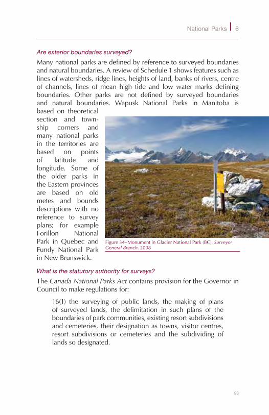
93
National Parks 6
Are exterior boundaries surveyed?
Manynationalparksaredefinedbyreferencetosurveyedboundariesandnaturalboundaries.AreviewofSchedule1showsfeaturessuchaslinesofwatersheds,ridgelines,heightsofland,banksofrivers,centreof channels, lines ofmean high tide and lowwatermarks definingboundaries. Other parks are not defined by surveyed boundariesand natural boundaries. Wapusk National Parks in Manitoba isbased on theoreticalsection and town-ship corners andmany national parksin the territories arebased on pointsof latitude andlongitude. Some ofthe older parks intheEasternprovincesare based on oldmetes and boundsdescriptions with noreference to surveyplans; for exampleForillon NationalPark in Quebec andFundy National ParkinNewBrunswick.
What is the statutory authority for surveys?
TheCanada National Parks ActcontainsprovisionfortheGovernorinCounciltomakeregulationsfor:
16(1) the surveying of public lands, the making of plansof surveyed lands, the delimitation in such plans of theboundariesofparkcommunities,existingresortsubdivisionsandcemeteries,theirdesignationastowns,visitorcentres,resort subdivisions or cemeteries and the subdividing oflandssodesignated.
Figure34–MonumentinGlacierNationalPark(BC).Surveyor General Branch.2008

94
S u r v e y S , P a r c e l S a n d T e n u r e o n c a n a d a l a n d S
Figure35–SurveyinginGlacierNationalPark(BC).Surveyor General Branch.2008
95
National Parks 6
Section 3(2) of theNational Parks of Canada Lease and Licence of Occupation Regulations outlines the requirements for surveys forleases.ThereisalsoprovisionforsurveysinSection4oftheNational Parks General Regulations.TheMinistermay,fromtimetotime,arrangetohavepubliclandsinaParksurveyedorresurveyed:
(a)intolotsintownsitesorothersubdivisions;(b)foranyright-of-way;387(c) for the purposes of schools, hospitals, churches and the
entertainmentofpersonsvisitingthePark;and(d)forthepurposesofacemetery.
How are land surveys and land transactions in national parks coordinated?
TheInterdepartmentalAgreementregardingsurveysandlanddescrip-tion applying to national parks is dated 1955.388 This agreement,whenitwasexecuted,appliedtoterritoriallands,nationalparks,andIndianreservesandtocertainotherfederalpubliclands.MuchofthisagreementisnowoutdatedanddiscussionshavestartedtoprepareanewversionforlandsmanagedbyParksCanada.389
What about surveys for other lands managed by Parks Canada?
ParksCanadaalsomanages:
◆ 155nationalhistoricsites;53ofwhichhavebeensetapartasnationalhistoricsitesofCanadapursuanttoSection42oftheCanada National Parks Act.390
◆ National marine conservation areas, which are establishedthrough amendment to the Canada National Marine Conservation Areas Act391 in a process similar to that inestablishing national parks. As for national parks, Canadamusthavetitletooranunencumberedrightofownershipinthelands.
◆ Nationalmarineconservationareareserveswherethelandissubjecttoalandclaim.392
◆ Heritagecanals,ordnancelandsandadmiraltylands.
387Canada National Parks ActS.C.2000,c.32,isnow15(1).388ChapterB1-1-InterdepartmentalAgreementreDescriptionofCanadaLands,1955(ExcludingIndianLands),
GeneralInstructionsforSurveys,e-Edition:SGBWebsite.AccessedOct.12,2010.389Gagnon,Jean.SurveyorGeneralsBranch,August12,2009.390See:NationalHistoricSitesofCanada:ParksCanadaWebsite.AccessedOct.12,2010.TheNationalHistoric
SitesofCanadaOrder,C.R.C.,c.1112,listsandgivesthelegaldescriptionofthenationalhistoricsitesofCanada.
391S.C.2002,c.18.392ParksCanadaGuidingPrincipleandOperationalPolicies(Updatedto2003-10-14)PartII,NationalMarine
ConservationAreasPolicy,Section1.5.2.
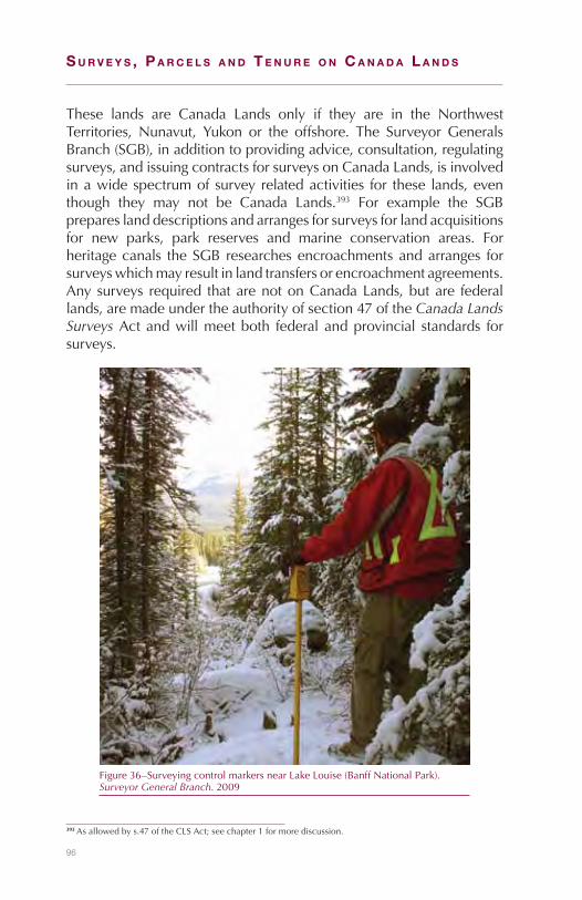
96
S u r v e y S , P a r c e l S a n d T e n u r e o n c a n a d a l a n d S
These lands are Canada Lands only if they are in the NorthwestTerritories, Nunavut, Yukon or the offshore. The SurveyorGeneralsBranch(SGB),inadditiontoprovidingadvice,consultation,regulatingsurveys,andissuingcontractsforsurveysonCanadaLands,isinvolvedinawidespectrumofsurveyrelatedactivities for these lands,eventhough they may not be Canada Lands.393 For example the SGBprepareslanddescriptionsandarrangesforsurveysforlandacquisitionsfor new parks, park reserves and marine conservation areas. Forheritagecanals theSGBresearchesencroachmentsandarranges forsurveyswhichmayresultinlandtransfersorencroachmentagreements.Anysurveys required thatarenotonCanadaLands,butare federallands,aremadeundertheauthorityofsection47oftheCanada Lands Surveys Actandwillmeetboth federalandprovincial standards forsurveys.
393Asallowedbys.47oftheCLSAct;seechapter1formorediscussion.
Figure36–SurveyingcontrolmarkersnearLakeLouise(BanffNationalPark).Surveyor General Branch.2009
97
7Northwest Territories
What are Canada Lands in the Northwest Territories (NWT)?
The NWT is Canada’s oldest territory. Only about 43,000 people,halfbeingAboriginal, live in the1.2millionsquarekilometresof itslandmass.394 The lands and resources aremanaged by the federalgovernment, the territorial government, and by several Aboriginalorganizations.
MostoftheCanadaLandsintheNWTareundertheadministrationandcontrolofthefederalGovernment.Theselands,commonlyreferredtoasfederallands,arecalled“territoriallands”intheapplicableactsandregulations.OtherCanada Lands includeCommissioner’s lands andTlicho lands. Even though theCommissioner has the administrationandcontrolofCommissioner’s lands theyareCanadaLandsas theyhaveremainedvestedinHerMajestyinrightofCanada.395Landsinwhichthe feesimpleinterest isvestedin theTlichogovernmentarealsoCanadaLands.396
What events led to the current land area?
Rupert’sLandandanadditionalarea,theNorth-WesternTerritory,wasformallyadmitted into theDominionofCanadaon July15,1870,397andbecameknownastheNorth-WestTerritories.398In1880theArcticislandswere transferred to Canada byGreat Britain andmade part394Facts,GovernmentoftheNWTWebsite.AccessedOct.12,2010.395NWT Act,R.S.C,1985,c.N-27,s.44(1),R.S.C.1985,c.L-6,s.24(1)(a).396Canada Lands Surveys Act,R.S.C.,1985,s.24.(1)(vi);TlichoAgreement,c.1definitions.397Order of Her Majesty in Council Admitting Rupert’s Land and the North-Western Territory into the Union,
23rddayofJune,1870.Dateofadmission,July15,1970,seeparagraph10398An Act for the temporary Government of Rupert’s Land and the North-Western Territory when united with
Canada,1869,c.3,s.1.
98
S u r v e y S , P a r c e l S a n d T e n u r e o n c a n a d a l a n d S
of theNorth-West Territories. The land areas: ofManitoba in1881,Ontario in1882andQuebec in1898 tookpartsof theNorth-WestTerritoriesandthediscoveryofgoldledtothecreationofaseparateYukon Territory in 1898. In the 20th century land continued to becarvedout.In1905theprovincesofAlbertaandSaskatchewanwerecreated. In 1912 the boundaries ofManitoba,Ontario andQuebecwerefurtherextendedintotheNWT(asitwasrenamedin1906)399andin1999theterritoryofNunavutwascreatedintheeasternArctic.400TheremaininglandconstitutesthepresentdayNWT.
How did the land management regimes evolve?
TheDominion Lands Act,4011872providedfor thesettlementof thelandsandasystemofsurvey.The North-West Territories Act, 1875402 providedforaLieutenant-Governor toadminister thegovernment insuchmattersastaxation,privatepropertyandcivilrights,justiceandhealth.OneoftheprovisionsintheActwasforaRegistrarofDeeds“whoshall registeralldeedsandother instruments relating to landssituateinanypartoftheNorth-WestTerritoriesandwhichhavebeenlaidoutandsurveyedbytheCrown”.403ThisprovisionwasreplacedbyThe Territories Real Property Act,404whichbroughtinalandtitlessystemforprivatelands.
TheseatoftheterritorialgovernmentwasfirstinBattlefordandafter1883 in Regina.405 However, the responsibility for Dominion LandsremainedfirmlyinOttawawiththeDepartmentoftheInterior.In1905,provisionwasmadeforaCommissionertoadministertheremainingpart of the North-West Territory.406 The early Commissioners heldseniorpositionsorweredeputyministersofdepartmentsinvolvedintheNorthand theycarriedout theirduties fromOttawa. Itwasnotuntil1967whenYellowknifebecame thecapital thatCommissionerStuartHodgsonresidedintheNWT.407
In1908,theDominion Lands Act wasconsolidatedandupdated.ThenewDominion Lands Act408appliedtoDominionlandsinManitoba,Saskatchewan, Alberta, to a portion of the Peace River district in399NWT Act,RSC1906,c.62.AlsoseeHistory of the Name of the NWT:ThePrinceofWalesNorthernHeritage
CentreWebsite.AccessedOct.12,2010.400Canadian Confederation, The NWT:CollectionsCanadaWebsite.AccessedOct.12,2010.401S.C.1872,c.23.402S.C. 1875,c.49.403The North-West Territories Act,S.C. 1875,c.49,s.54.404S.C.1886,c.26.405Phillips,Canada’s North,1967,pp.244.406An Act to amend the Act respecting the North-west Territories,1905,c.27,s.4.407Office of the Commissioner of the NWT, Past Commissioners;NWT Data Book,1990/91,p.42,43;.Phillips,
Canada’s North,1967,p.244.408S.C.1908,c.20.
99
Northwest Territories 7
BritishColumbiaand to theNWT.Because theprovisions regardingsurveysweredeemedseparate fromtheprovisionsof theDominion Lands ActtheywereremovedandincorporatedintoanewDominion Lands Surveys Act.409 TheAct applied to the public lands that theDominion Lands Act applied to and also to the public lands of theDominionofCanadaintheYukon.410
In the 1920s, economic activity in the NWT picked up. Oil wasdiscovered at Norman Wells and there was mining developmentaroundGreatBearandGreatSlavelakesinthe1930’s.Theintroductionof northern bush flying facilitated the development.411 Despite thisactivitytherewasnogroundswellofsupporttoadvancethepoliticaldevelopmentoftheNWT.412WorldWarIIprojectssuchasthebuildingoftheAlcanhighway(nowtheAlaskahighway)andtheCanolproject(a project that built a pipeline and a road from Norman Wells toWhitehorse)andpostwaractivity,suchastheDistantEarlyWarning(DEW)line,broughtadditionaleconomicactivity.413
Intheearly1950’sthemainpurposeoftheDominion Lands Act,theorderlydevelopmentof thewest, had long sincepassed. In1950 itwasrepealedandreplacedbytheTerritorial Lands Act414whichwasmoresuitedtoconditionsintheNWTandtheYukon.SeveralchangeswerealsomadetotheNWT Act,includinggrantingtheCommissionerinCouncil greater responsibilities415 oneofwhich, in1955,was the“right to thebeneficialuseor to theproceeds thereof”of lands thatwererequiredfor territorialpurposes.416TheselandsbecameknownasCommissioner’sLands.
In 1974 Justice ThomasBergerwas engaged by theGovernment ofCanadatoinquireintotermsandconditionsthatshouldbeimposedif a pipeline was to be built through the Northern Yukon and theMackenzie Valley.417 Berger obtained input from representatives ofindustry, environmentalists and government and he traveled to 35communitiestoheartheviewsofAboriginalsandothernortherners.As a backdrop to his inquiry, during the 1970s aboriginal politicalorganizations in the North began to assert their Aboriginal land4091908,c.21.Debates, House of Commons,February15,1907,p.3093410Dominion Lands Surveys Act,S.C.1908,c.21,s.3.S.C.Dominion Lands Act,1908,c.20,ss.3,5.411History of Bush Flying:OntarioMinistryofNaturalResourcesWebsite.412Phillips,Canada’s North,1967,pp.244–246.413The Canadian North: Embracing Change.June2002,CentreforResearchandInformationonCanada,
pp.10–11;The Canadian Indian, Yukon and the NWT,1973,IndianandNorthernAffairs,pp.38,39.414S.C.1950,c.22.Debates, House of Commons,May10,1950,pp.2364-5415NWT Data Book,1990/91,p.42.416An Act to amend the Acts respecting the NWT1954,c.8,s.114.(ItcameintoforceonApril1,1955).417Mr.JusticeThomasR.Berger.Northern Frontier, Northern Homeland - The Report of the Mackenzie Valley
Pipeline Inquiry: Volume One. 1977.
100
S u r v e y S , P a r c e l S a n d T e n u r e o n c a n a d a l a n d S
rights.418 In his 1977 report,Northern Frontier Northern Homeland,herecommendedthatnopipelinebebuiltalongtheNorthernYukonrouteandthattheMackenzieValleypipelinebedelayedfortenyearstoallowtimeforAboriginallandclaimstobesettled.419ThereportwassignificantbecauseitraisedawarenessofnorthernAboriginalrights
What is being done to protect the land and resources?
Extensiveconsultationisundertakentoensurecompliancewithlanduseplans,wheretheyexist,andtoaddressenvironmentalconcerns.TheCanadian Environmental Assessment Act420appliestotheInuvialuitSettlement Area and the Mackenzie Valley Resource Management Act421applieswithintheMackenzieValley.Authorizationsforlandandwaterusearegivenbythevariouslandandwaterboardsestablishedunder thecomprehensive landclaimsettlementagreementsand theMackenzie Valley Resource Management Act.EachboardconsistsofrepresentativesfromtheAboriginalorganizationresponsibleforeachsettlementarea,theGovernmentoftheNWTandtheGovernmentofCanada.TheGwich’inLandandWaterBoard,TheSahtuLandandWaterBoardandtheWekeezhii(Tlicho)LandandWaterBoardissueslandusepermitsandwaterlicenceswithintheirrespectivesettlementareas. TheMackenzieValley Land andWaterBoardwill issue landuse permits and water licences in the unsettled claims area in theMackenzieValleyuntilthebalanceofthelandclaimsaresettled.
What is the status of devolution?
TheterritorialgovernmentandAboriginalorganizationshavereceivedconsiderable control of responsibilities from the federal governmentover the past several years and negotiations are now underway totransfer theadministrationandcontrolof landsandresourcestotheGovernment of the NWT. The latest significant development wasthesigningoftheNWT Lands and Resources Devolution Framework Agreementin2004bytheGovernmentofCanada,theGovernmentoftheNWTandbyAboriginalorganizations.
418ElijahSmith,1973,Together Today for our Children Tomorrow: by the Yukon Indian People.TheformationoftheInuitTapirisatofCanada(ITC)intheWesternArcticin1971.
419Mr.JusticeThomasR.Berger.Northern Frontier, Northern Homeland - The Report of the Mackenzie Valley Pipeline Inquiry: Volume One. 1977.p.p.xxvi-vii.
420S.C.1992,c.37.421SC1998,c.25,s.46.TheMackenzieValleyasdefinedintheActincludesalloftheNWT,withtheexception
oftheInuvialuitSettlementRegionandWoodBuffaloNationalPark.

101
Northwest Territories 7
What are territorial lands?
TheTerritorial Lands Act422defines territorial landsas“lands,oranyinterestinlands,intheNWTorNunavutthatarevestedintheCrownorofwhichtheGovernmentofCanadahaspowertodispose.”LandasdefinedintheAct“includesmines,minerals,easements,servitudesandallotherinterestsinrealproperty.”
The Territorial Lands Act only applies to territorial lands underthe administration of the Minister of Indian Affairs and NorthernDevelopment (INAC).423 Over the years many tracts of territoriallands have been withdrawn from disposal under the Act or theiradministrationhasbeentransferredtoothers.Forexample,landshavebeenwithdrawnunderSection23(a)oftheActtofacilitatesettlementoflandclaims,fortheestablishmentofnationalparks, toallowlandremediationandtoallowfordevelopment.424Landsareadministeredby other government departments such as the Departments ofTransportation andNationalDefense. Landsmay also be under theadministration of Crown corporations to be used only for specificgovernmentorCrownCorporationpurposes.
TheNWT Actprovidesforthetransferofadministrationandcontrolofterritoriallandsbyorder-in-councilfromINACtotheCommissioner.425Similarly under the Act the Commissioner may transfer, with theapprovaloftheGovernorinCouncil,theadministrationandcontrolofCommissioner’slandstoanyministeroftheGovernmentofCanada.426The Federal Real Property and Federal Immovables Act427 governstransfers toother federalministersand thesaleand leasingof landsadministered by other federalministers.However it does not affecttheapplicationoftheTerritorial Lands ActorotherlegislationapplyingtonationalparksandFirstNationsReserves,or the rightsofCrowncorporationsasdefinedundertheirownActs.428
422R.S.C.,1985,c.T-7.Definitionss.2423Territorial Lands Act,R.S.C.,1985,c.T-7.s.3424R.S.C.,1985,c.T-7,s.23.SeevariousregulationsundertheTerritorialLandsAct.OrderRespectingthe
WithdrawalfromDisposalofCertainLandsintheNWT(GiantMine)(SI/2005-55)andOrderRespectingtheWithdrawalfromDisposalofCertainSubsurfaceLandsintheNWT(SI/2003-36).
425NWT Act,R.S.C.,1985,c.N-27,s.44.1426NWT Act,R.S.C.,1985,c.N-27,s.44.(3).427S.C.1991,c.50428The Federal Real Property and Federal Immovables Act,S.C.1991,c.50.s.16(1)(g).Guide to the Federal Real
Property Act and Federal Real Property Regulation,TreasuryBoardofCanadaSecretariat.
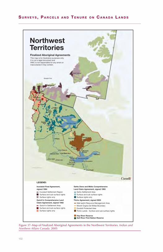
102
S u r v e y S , P a r c e l S a n d T e n u r e o n c a n a d a l a n d S
Figure37–MapofFinalizedAboriginalAgreementsintheNorthwestTerritories.Indian and Northern Affairs Canada.2005
Inuvialuit Final Agreement,signed 1984
Inuvialuit Settlement RegionSurface and sub-surface rightsSurface rights only
Gwich’in Comprehensive LandClaim Agreement, signed 1992
Gwich’in Settlement AreaSurface and sub-surface rightsSurface rights only
Sahtu Dene and Métis ComprehensiveLand Claim Agreement, signed 1993
Sahtu Settlement AreaSurface and sub-surface rightsSurface rights only
Tlicho Agreement, signed 2003
Wek’eezhli Resource Management AreaMowhi Gogha De Niitlee BoundaryEzodziti Protected AreaTlicho Lands - Surface and sub-surface rights
LEGEND:
Hay River ReserveSalt River First Nation Reserve
This map is for illustrative purposes only.It is not a legal document andINAC is not responsible for any errors orinaccuracies it may contain.
Finalized Aboriginal Agreements
NorthwestTerritories

103
Northwest Territories 7
How are surface rights managed?
TheLandAdministrationOfficeofINACinYellowknifemanagessurfacelandactivitiesonterritoriallandsincludingdispositionofsurfacerightsandmaintenance of the Land Administration Registry. The Registrycontains leases, permits andother instruments of territorial lands.429Some76%of the surface land area in theNWT is estimated to beundertheadministrationofINAC;thispercentagewilldecreaseastheremainingcomprehensivelandclaimsaresettled.430
Both the Territorial Lands Act and Territorial Lands Regulations431 contain provisions regarding the sale of territorial lands.432 UnderSection9oftheActthegrantingoflandsbyletterspatentinfeesimpleiscarriedoutbynotificationissuedtoaregistrardirectingtheissuanceofacertificateof title to thepersonnamed in it.Reservations fromgrants,giveninSection13-16oftheAct,include:
◆ a strip of land one hundred feet in width where the landextends to the sea, to the shoreofnavigablewaters and toprovincial,territorialorinternationalboundaries;
◆ thebed,belowordinaryhighwatermarkofbodiesofwater;◆ minesandminerals;and◆ rightsoffisheryandfishing.
Letters patent (by notification) for territorial lands are not issueduntil a plan of survey has been approved and confirmed by theSurveyorGeneralandregistered in the land titlesoffice.Thesurveyof all unsurveyed territorial landsmust bemadebyCLSsunder theinstructionsoftheSurveyorGeneral.433Specificsurveyinstructionsarerequired.
INACrarelysellsland;mostdispositionsgrantingexclusiveuseoflandto individuals isby lease.Termsof leasesare30yearsor less,withprovisionforrenewals.Therearealsoseveralreservationsfromleases,suchasminesandminerals,whichincludesoilandgas,andtherightto enter the lands to extract theminerals.434 There are no statutoryrequirementsforleasestobesurveyed.
429A“SpatiallyIntegratedDataset”(SID)isaccessibleonlinethatcontainsinformationonINACsurfacedispositionsandpermits.INACWebsite.AccessedOct.12,2010.
430Areasbasedonsettlementagreementstodate(approximately14%).Aswell,NationalParks,TerritorialParks,otherlandswithdrawnfromdisposalandCommissioner’slandareestimatedtocomprise10%ofthelandandwaterarea.
431C.R.C.,c.1525.432Territorial Lands Act, R.S.C.,1985,c.T-7.ss.3(2),s.9,12-16,23(k).433Territorial Lands Regulations,C.R.C.,c.1525,s.9(1)(2).434Territorial Lands Act,R.S.C.,1985,c.T-7,ss.8,11(2,3),19.Territorial Lands Regulations,C.R.C.,c.1525,ss.10,
12.

104
S u r v e y S , P a r c e l S a n d T e n u r e o n c a n a d a l a n d S
TheTerritorial Land Use Regulations435regulatetheissuanceofpermitsfor land use operations. Two types of permits can be issued undertheRegulations: ClassA andClass B.ClassA permits are formoreextensive and longer term operations. A preliminary plan showingthelandsproposedtobeusedandafinalplanafterthecompletionofthelanduseoperationarerequired.436Theseplanshavenotbeenconsideredas legalsurveyplansandassucharenot required tobepreparedbyaCLS.TheTerritorial Land Use RegulationsdonotapplytolanduseoperationsintheMackenzieValleyasoperationsinthatareaaredealtwithundertheMackenzie Valley Resource Management Act.437
TheTerritorial Quarry Regulations438authorizetheissuanceofpermitsandquarry leases for the takingofmaterial suchas sand,gravel,orstone. Permits are normally valid for a maximum of one year andspecifytheamountandlocationofmaterialtoberemoved.Termsofleasescanbeupto10years.Applicationsforquarryleasesrequireasketchshowingclearlythepositionoftheparcelinrelationtoasurveymonument,prominenttopographicalfeatureorotherknownpoint.439
Mineralleasesorlicencestodevelopoilorgasdonotincludetherighttooccupyandusesurfacelands.Surfaceareasrequired;forexample,forroads,camps,airstrips,wellsites,pipelinesandotherfacilitiesmustbeacquiredthroughalease,permitorotheragreementwiththeLandAdministrationOfficeofINAC.
How are mineral rights managed?
The NWT and Nunavut Mining Regulations440 defines minerals asnaturallyoccurringinorganicsubstancefoundonorunderanysurfaceofland.Thedefinitionexcludesnon-metallicsubstancessuchasstone,clay,gravelandsoil.Thetakingofthesesubstancesarenormallydealtwithunderquarryregulations. In theNWToilandgas isdealtwithseparately.Thetermmineralrightsareoftenusedinthesamecontextasthetermsubsurfacetitle.
There are four operating mines in the NWT: the North AmericanTungsten Cantung mine located in the Nahanni area of the NWT
435C.R.C.,c.1524.436Territorial Land Use Regulations,C.R.C.,c.1524,s.22(2).437Territorial Land Use Regulations,C.R.C.,c.1524,s.6(f).Thereareexceptions;forexample,land-useoperations
authorizedbyapermitissuedpriortothecomingintoforceofPart3oftheMackenzie Valley Resource Management Act.
438C.R.C.,c.1527439Territorial Quarry Regulations,C.R.C.,c.1527,ss.6(1)(c),5-12.440C.R.C.,c.1516.
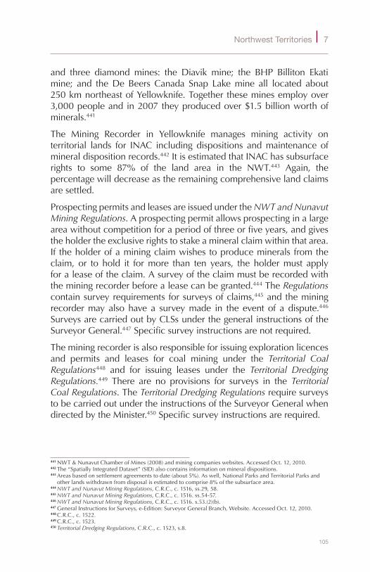
105
Northwest Territories 7
and three diamond mines: the Diavik mine; the BHP Billiton Ekatimine; and theDe Beers Canada Snap Lakemine all located about250kmnortheastofYellowknife.Togethertheseminesemployover3,000peopleandin2007theyproducedover$1.5billionworthofminerals.441
The Mining Recorder in Yellowknife manages mining activity onterritorial lands for INAC including dispositions andmaintenance ofmineraldispositionrecords.442ItisestimatedthatINAChassubsurfacerights to some 87% of the land area in the NWT.443 Again, thepercentagewilldecreaseastheremainingcomprehensivelandclaimsaresettled.
ProspectingpermitsandleasesareissuedundertheNWT and Nunavut Mining Regulations.Aprospectingpermitallowsprospectinginalargeareawithoutcompetitionforaperiodofthreeorfiveyears,andgivestheholdertheexclusiverightstostakeamineralclaimwithinthatarea.If theholderofaminingclaimwishestoproduceminerals fromtheclaim, or to hold it formore than ten years, the holdermust applyforaleaseoftheclaim.Asurveyoftheclaimmustberecordedwiththeminingrecorderbeforealeasecanbegranted.444TheRegulationscontainsurveyrequirements forsurveysofclaims,445andtheminingrecordermayalsohavea surveymade in the eventof adispute.446SurveysarecarriedoutbyCLSsunderthegeneralinstructionsoftheSurveyorGeneral.447Specificsurveyinstructionsarenotrequired.
Theminingrecorderisalsoresponsibleforissuingexplorationlicencesand permits and leases for coal mining under the Territorial Coal Regulations448 and for issuing leases under the Territorial Dredging Regulations.449 There are no provisions for surveys in the Territorial Coal Regulations.TheTerritorial Dredging Regulations requiresurveystobecarriedoutundertheinstructionsoftheSurveyorGeneralwhendirectedbytheMinister.450Specificsurveyinstructionsarerequired.
441NWT&NunavutChamberofMines(2008)andminingcompanieswebsites.AccessedOct.12,2010.442The“SpatiallyIntegratedDataset”(SID)alsocontainsinformationonmineraldispositions.443Areasbasedonsettlementagreementstodate(about5%).Aswell,NationalParksandTerritorialParksand
otherlandswithdrawnfromdisposalisestimatedtocomprise8%ofthesubsurfacearea.444NWT and Nunavut Mining Regulations,C.R.C.,c.1516,ss.29,58.445NWT and Nunavut Mining Regulations,C.R.C.,c.1516.ss.54-57.446NWT and Nunavut Mining Regulations,C.R.C.,c.1516.s.53.(2)(b).447GeneralInstructionsforSurveys,e-Edition:SurveyorGeneralBranch,Website.AccessedOct.12,2010.448C.R.C.,c.1522.449C.R.C.,c.1523.450Territorial Dredging Regulations,C.R.C.,c.1523,s.8.

106
S u r v e y S , P a r c e l S a n d T e n u r e o n c a n a d a l a n d S
How are oil and gas rights managed?
TheNWTisrichinoilandnaturalgas.TheNormanWellsoilfield,the fourth largest inCanada, has been in production since 1943. Itproducesbetween6and7millionbarrels(valuedbetween$450and$500million dollars) per year. To date over 1900wells have beendrillednorthof60,mostintheNWT.Thereareanestimated6trillioncubicfeetofdiscoveredgasreservesandanadditional55trillioncubicfeetoflikelygasreserveswithintheMackenzieDelta/BeaufortSearegionwhichcanbemarketedwhentheproposedMackenzieValleyGasPipelineiscompleted.451
TheregulatoryresponsibilityforoilandgasonterritoriallandsissharedbytheMinisterofINACandtheMinisterofNaturalResourcesCanada(NRCan).Documentsthatpertaintooilandgasinterestsareregisteredin INAC’s Canada Frontier Lands Registration System in Gatineau,Quebec.452 There are two primary Acts that apply. The Canada Petroleum Resources Act453 deals with oil and gas interests and ismanagedbyINAC.TheCanada Oil and Gas Operations Act454appliesto oil and gas operations such as exploration, drilling, production,conservation,processingandtransportation455andismanagedthroughtheNationalEnergyBoard.
ThreetypesofdispositionsmaybeissuedbyINACundertheCanada Petroleum Resources Act:
◆ anexplorationlicencegives theright toexplore forandtheexclusiverighttodrillandtestforpetroleumandtodevelopthelandsinordertoproducepetroleum;456
◆ asignificantdiscoverylicence,inadditiontotherightsunderanexplorationlicence,givestheexclusiverighttothelandsinordertoproducepetroleum;457
◆ aproductionlicence,inadditiontotherightsunderasignificantdiscovery licence, gives the exclusive right to develop
451Miningoilandgasfacts:DepartmentofIndustry,TourismandInvestment,NWTwebsite.AccessedOct.12,2010.
452Frontier Lands Registration Regulations,SOR/88-230madepursuanttothefederalCanada Petroleum Resources Act. CopiesofdocumentsareavailablefromtheOfficeoftheRegistrar,NorthernOilandGasDirectorateinGatineau,Quebec.The“SpatiallyIntegratedDataset”(SID)alsocontainsinformationonmineraldispositions.
453R.S.C.,1985,c.36(2ndSupp.)454R.S.C.,1985,c.O-7.455FrontierOilandGas:NationalEnergyBoardWebsite.AccessedOct.12,2010.AlsoseeOil and Gas
Approvals in the NWT - Gwich’in Settlement Area,2002.Erlandson&AssociatesConsultants.456Canada Petroleum Resources ActR.S.C.,1985,c.36(2ndSupp.)s.22.457R.S.C.,1985,c.36(2ndSupp.)s.28.

107
Northwest Territories 7
petroleumandconferstitletothepetroleumproducedwhereacommercialdiscoveryhasbeenmade.458
The Norman Wells Proven Area Agreements, first entered into in1944, between the federal government and Imperial Oil Limited,grantsImperialOiltheexclusiverightandprivilegetodrillfor,mine,andextractpetroleumandnaturalgasfromtheNormanWellsoilandgasfield.Asapartner,theGovernmentofCanadareceivesone-thirdownership interest in the gross production. In order to allow theagreementstocontinuetheyhavebeenexcludedfromapplicationoftheCanada Petroleum Resources Act.459
Legal surveys approved by the Surveyor General are required forexploratorywellsandfordevelopmentwells.460TheCanada Oil and Gas Land Regulations461 under the Territorial Lands Act deals withsurveyrequirementsanddefinesthegridareasystemusedforspacingwells.Thepositionsofwellsare tobeshownon thesurveyplan inrelationship to grid areas, sections, and units; all referenced to theNorthAmericanDatumof1927.462However,bothdatums–NAD27andNAD83(CSRS)-arenowbeingshownonsurveyplans,giventhatindustryiscomfortableworkinginthelatterdatum.
WhentheSurveyorGeneralapprovesaplanofsurveypursuanttotheRegulations,thepositionalinformationshownontheplanisconfirmed.Iftheplanisthefirstplanapprovedinagridarea,thenthepositionalinformationshownontheplanfixesalltheboundariesofthegridareaforsubsequentsurveys.463AlthoughgeneralinstructionsareavailableforthesesurveysCLSsshouldalsocontacttheSGBinYellowknifeforadditional instruction and guidance (particularly for surveys in thehigherlatitudes).464
458R.S.C.,1985,c.36(2ndSupp.)s.37.459R.S.C.,1985,c.36(2ndSupp.),s.114(5).HouseofCommonsDebates,Sept.23,1994.Agreements:P.C.1944-
5594,P.C.1983-3132andP.C.1994-1939).460Canada Oil and Gas Land RegulationsC.R.C.,c.1518,s.20,21.461C.R.C.,c.1518,ss.10-22.SomeprovisionsintheRegulationshavebeenreplacedbyprovisionsintheCanada
Petroleum Resources Act, althoughtheRegulationsremaininforcetotheextentthattheyarenotinconsistentwiththatAct; seeCanada Petroleum Resources Act,R.S.C.,1985,c.36(2ndSupp.)s.112.
462Canada Oil and Gas Land RegulationsC.R.C.,c.1518,s.9.AsofJuly2010,theregulationshavenotyetbeenreplacedbyregulationstobeenactedpursuanttotheCanada Petroleum Resources Act,whichwilladopttheNAD83(CSRS)datum.
463GeneralInstructionsforSurvey,e-edition,PartD7,ChapterE-1,s.4.464AnitaLemmetty,SeniorSurveyor,SGB,NWT/Nunavut,Telecon:March2,2010.
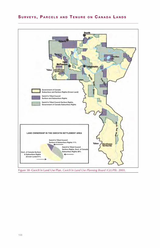
108
S u r v e y S , P a r c e l S a n d T e n u r e o n c a n a d a l a n d S
Government of CanadaSubsurface and Surface Rights (Crown Land)
Gwich’in Tribal CouncilSurface and Subsurface Rights
Gwich’in Tribal Council Surface Rights,Government of Canada Subsurface Rights
LAND OWNERSHIP IN THE GWICH’IN SETTLEMENT AREA
NÀNH’ GEENJIT GWITR’IT T’IGWAA’IN / GWICH’IN LAND USE PLAN
Gwich’in Tribal CouncilSurface & Subsurface Rights 11%
Govt. of Canada Surface& Subsurface Rights
(Crown Land) 61%
Gwich’in Tribal CouncilSurface Rights, Govt. of CanadaSubsurface Rights 28%
Figure38–Gwich’inLandUsePlan.Gwich’in Land Use Planning Board (GLUPB).2003.

109
Northwest Territories 7
What are Commissioner’s lands?
Commissioner’slandsarelandsthat,whiletheyremainvestedinHerMajesty theQueen in rightofCanada,areunder theadministrationand control of the Commissioner and managed by the territorialgovernment. Commissioner’s lands are defined in the NWT Act465 andthe Commissioner’s Land Act.466ThemajorityofCommissioner’slandsconsistoflargetractsofland(notincludingminesandminerals)in and adjacent to communities and roads, streets, lanes and trailson public land. The administration and control of these lands aretransferred by order in council from the federal government to theterritorialgovernmentforcommunitydevelopment.Priortothe1990’sthe transferof large tractsof land, calledblock land transfers,weredescribed bywritten description.Now the lands transferred are forsmallerparcelsandsurveysundertheCanada Lands Surveys Act arerequired.467Commissioner’slandscompriseonly2%ofthelandmassintheNWT.
How are Commissioner’s lands managed?
The Lands Administration Division of the territorial Department ofMunicipalandCommunityAffairs(MACA)inYellowknifeadministersCommissioner’s lands. The Division also maintains a registry thatcontains leases, permits and other instruments of Commissioner’sland.468
UndertheNWT ActandtheCommissioner’s Land Act theCommis-sionermayuse,sellorotherwisedisposeofCommissioner’slandandretaintheproceeds.469SectionsintheTerritorial Lands ActthatapplytothesaleofterritoriallandsequallyapplytothesaleofCommission-erslands:forexample,notificationsunderSection9andreservationsfromgrantsunderSection13-16.470Asforterritorial lands, theCom-misioner’slandstobesoldmustbesurveyed.UnderSection3(3)oftheCommissioners Land Act“NoCommissioner’slandshallbesolduntiladulyapprovedplanofsurveyofthelandhasbeenfiledinthelandtitlesoffice for the registrationdistrict inwhich the land is located.”
465R.S.C,1985,c.N-27,s.44(1)466R.S.N.W.T.1988,c.C-11,s.2.467BeverlyChamberlin,ManagerLands,GovernmentoftheNWT,Telecon:Nov.23,2009.468GraphicandtextualinformationaboutparcelsoflandlocatedwithintheboundariesofCommunity
GovernmentscanbeaccessedonlinethroughATLAS:GovernmentoftheNWTWebsite.AccessecOct.12,2010.
469R.S.C,1985,c.N-27,s.44(2).R.S.N.W.T.1988,c.C-11,s.3.470Unders.3.(2)oftheTerritorial Lands Act,R.S.C,1985,c.T-7,Sections9and12to16andparagraph23(k)
applytoterritoriallandsundertheadministrationandcontroloftheCommissioneroftheNWToroftheCommissionerofNunavut.
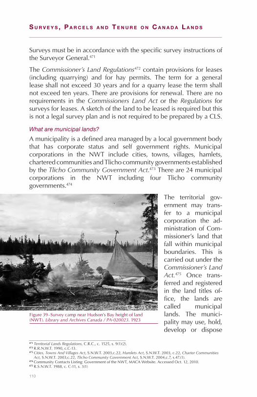
110
S u r v e y S , P a r c e l S a n d T e n u r e o n c a n a d a l a n d S
SurveysmustbeinaccordancewiththespecificsurveyinstructionsoftheSurveyorGeneral.471
TheCommissioner’s Land Regulations472containprovisionsforleases(including quarrying) and for hay permits. The term for a generalleaseshallnotexceed30yearsandforaquarryleasethetermshallnotexceedtenyears.Thereareprovisionsforrenewal.Therearenorequirements in theCommissioners Land Act or theRegulations forsurveysforleases.AsketchofthelandtobeleasedisrequiredbutthisisnotalegalsurveyplanandisnotrequiredtobepreparedbyaCLS.
What are municipal lands?
Amunicipalityisadefinedareamanagedbyalocalgovernmentbodythat has corporate status and self government rights. Municipalcorporations in the NWT include cities, towns, villages, hamlets,charteredcommunitiesandTlichocommunitygovernmentsestablishedbytheTlicho Community Government Act.473Thereare24municipalcorporations in the NWT including four Tlicho communitygovernments.474
The territorial gov-ernment may trans-fer to a municipalcorporation the ad-ministrationofCom-missioner’s land thatfallwithinmunicipalboundaries. This iscarriedoutundertheCommissioner’s Land Act.475 Once trans-ferredandregisteredin the land titles of-fice, the lands arecalled municipallands. The munici-palitymayuse,hold,develop or dispose
471Territorial Lands Regulations,C.R.C.,c.1525,s.9(1)(2).472R.R.N.W.T.1990,c.C-13.473Cities, Towns And Villages Act,S.N.W.T.2003,c.22,Hamlets Act,S.N.W.T.2003,c.22,Charter Communities
Act,S.N.W.T.2003,c.22,Tlicho Community Government Act,S.N.W.T.2004,c.7,s.47.(1).474CommunityContactsListing:GovernmentoftheNWT,MACAWebsite.AccessedOct.12,2010.475R.S.N.W.T.1988,c.C-11,s.3(1)
Figure39–SurveycampnearHudson’sBayheightofland(NWT).Library and Archives Canada / PA-020023.1923
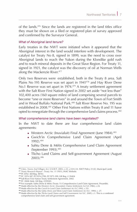
111
Northwest Territories 7
ofthelands.476SincethelandsareregisteredinthelandtitlesofficetheymustbeshownonafiledorregisteredplanofsurveyapprovedandconfirmedbytheSurveyorGeneral.
What of Aboriginal land tenure?
Early treaties in theNWTwere initiatedwhen it appeared that theAboriginalinterestinthelandwouldinterferewithdevelopment.Thecatalyst forTreatyNo8,signedin1899,wastheneedtocrossoverAboriginal lands to reach the Yukon during the Klondike gold rushandtoreachmineraldepositsintheGreatSlaveRegion.ForTreaty11,signedin1921,thecatalystwasthediscoveryofoilatNormanWellsalongtheMackenzieRiver.477
OnlytwoReserveswere established,bothin theTreaty8area.SaltPlainsNo195Reservewassetapart in1941478andHayRiverDeneNo.1Reservewassetapartin1974.479AtreatysettlementagreementwiththeSaltRiverFirstNationsignedin2002setaside“notlessthan”102,400acres(160squaremiles)oflandcomprisingseveralparcelstobecome“oneormoreReserves”inandaroundtheTownofFortSmithandinWoodBuffaloNationalPark.480SaltRiverReserveNo.195wasestablishedin2008.481OtherFirstNationswithinTreaty8and11haveoptedtorenegotiatethroughthecomprehensivelandclaimsprocess.482
What comprehensive land claims have been negotiated?
In the NWT to date there are four comprehensive land claimagreements:
◆ WesternArctic(Inuvialuit)FinalAgreement(June1984).483◆ Gwich’in Comprehensive Land Claim Agreement (April1992).484
◆ SahtuDene&MétisComprehensiveLandClaimAgreement(September1993).485
◆ TlichoLandClaimsandSelf-governmentAgreement(August2003).486
476Cities, Towns And Villages Act,S.N.W.T.2003,c.22,s.53(1),54.NWTPolicy21.02,MunicipalLands477Treaty Research Report - Treaty No. 11(1921),INACWebsite.478PC8761.ILRReg.#8761.479PC1974-387,PC1974-2789,PC1975-399.ILRReg.#39404480SaltRiverFirstNationTreatySettlementAgreement,2002.481PC2008-1666.ILRReg.#359301.482Forexample:SahtuDene&Métis(Treaty11)ComprehensiveLandClaimAgreement,Preamble.483MadeeffectivebytheWestern Arctic (Inuvialuit) Claims Settlement ActS.C.1984,c.24.484MadeeffectivebytheGwich’in Land Claim Settlement ActS.C.1992,c.53)485MadeeffectivebytheSahtu Dene and Metis Land Claim Settlement ActS.C.1994,c.27.486MadeeffectivebytheTlicho Land Claims and Self Government ActS.C.2005,c.1.Thisisacombined
comprehensivelandclaimandself-governmentagreement.
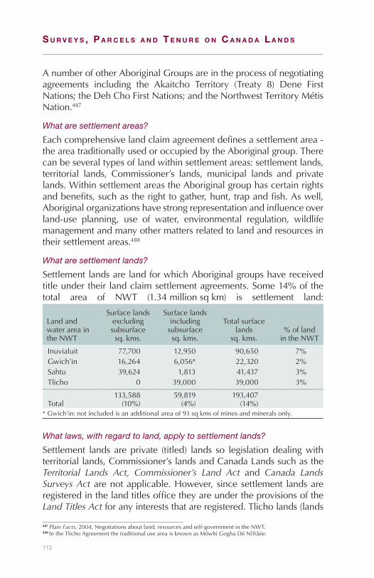
112
S u r v e y S , P a r c e l S a n d T e n u r e o n c a n a d a l a n d S
AnumberofotherAboriginalGroupsareintheprocessofnegotiatingagreements including the Akaitcho Territory (Treaty 8) Dene FirstNations;theDehChoFirstNations;andtheNorthwestTerritoryMétisNation.487
What are settlement areas?
Eachcomprehensivelandclaimagreementdefinesasettlementarea-theareatraditionallyusedoroccupiedbytheAboriginalgroup.Therecanbeseveraltypesoflandwithinsettlementareas:settlementlands,territorial lands, Commissioner’s lands, municipal lands and privatelands.WithinsettlementareastheAboriginalgrouphascertainrightsandbenefits,suchastherighttogather,hunt,trapandfish.Aswell,Aboriginalorganizationshavestrongrepresentationandinfluenceoverland-use planning, use of water, environmental regulation, wildlifemanagementandmanyothermattersrelatedtolandandresourcesintheirsettlementareas.488
What are settlement lands?
SettlementlandsarelandforwhichAboriginalgroupshavereceivedtitleundertheirlandclaimsettlementagreements.Some14%ofthetotal area of NWT (1.34millionsqkm) is settlement land:
LandandwaterareaintheNWT
Surfacelandsexcludingsubsurfacesq.kms.
Surfacelandsincludingsubsurfacesq.kms.
Totalsurfacelands
sq.kms.%oflandintheNWT
Inuvialuit 77,700 12,950 90,650 7%Gwich’in 16,264 6,056* 22,320 2%Sahtu 39,624 1,813 41,437 3%Tlicho 0 39,000 39,000 3%
Total133,588(10%)
59,819(4%)
193,407(14%)
*Gwich’in:notincludedisanadditionalareaof93sqkmsofminesandmineralsonly.
What laws, with regard to land, apply to settlement lands?
Settlement lands areprivate (titled) lands so legislationdealingwithterritoriallands,Commissioner’slandsandCanadaLandssuchastheTerritorial Lands Act, Commissioner’s Land Act and Canada Lands Surveys Actarenotapplicable.However, sincesettlement landsareregisteredinthelandtitlesofficetheyareundertheprovisionsoftheLand Titles Actforanyintereststhatareregistered.Tlicholands(lands
487Plain Facts, 2004,Negotiationsaboutland,resourcesandself-governmentintheNWT.488IntheTlichoAgreementthetraditionaluseareaisknownasMôwhíGoghaDéNîîtåée.

113
Northwest Territories 7
inwhich the fee simple interest isvested in theTlichogovernment)areCanadaLands.489ThereforetheTlichoGovernmentmightincluderequirements for surveys to be carried out under provisions of theCanada Lands Surveys Act.490
What land interests are available?
Asageneralrule,set-tlementlandsmaynotbeconveyed(sold)toany person exceptto the Governmentof Canada or theGovernment of theNWT in exchangefor other lands or toan organization oftheAboriginalgroup.Also, the lands arenotsubjecttoseizureand cannot bemortgaged.491 Thereareafewexceptions;for example, theGwich’in and theSahtuDene &Métis Agreements have provisions for holding landswithinmunicipalgovernmentboundariessothatlandmaybeavailableforAboriginals for residential, commercial, industrial and traditionalpurposes. These lands may be sold to any person and thereuponceasetobeGwich’inorSahtuDene&Métismunicipallands.Underthe Inuvialuit Agreement there is provision for selling, leasing orotherwise disposing of land tomunicipal governments where thereisademonstratedneed.492TheTlichoAgreementprovides thatafterthe20thanniversaryoftheAgreement(in2023),feesimpleinTlichocommunitylandsmaybeconveyedifauthorizedbyreferendum.493
Each Aboriginal group has the option of implementing a systemfor recording dispositions of its lands and resources. Most have
489Canada Lands Surveys Act,R.S.C.,1985,c.L-6,s.24.(1)(vi);TlichoAgreement,c.1definitions490TlichoAgreement,paragraph7.4.2(a).491SahtuDene&MétisAgreement,paragraphs7.1.2,19.1.5,19.1.7,19.1.8.Otheragreementshavesimilar
provisions.492Gwich’inAgreement,paragraphs22.1.1,22.2.2.SahtuDene&MétisAgreement,paragraphs23.1.1,23.2.2.
InuvialuitAgreement,paragraph7.(61).493TlichoAgreement,paragraph9.3.6.
Figure40–TopographicsurveyofFortSimpson(NWT).Library and Archives Canada / PA-020380.1929

114
S u r v e y S , P a r c e l S a n d T e n u r e o n c a n a d a l a n d S
requirementswithregardtograntingsurface,mineralandoilandgasrights on their settlement lands. For example, the Gwich’in Lands,Resources,andImplementationDepartmenthasestablishedguidelinesandfeesfortheuseofGwich’inlandsincludingcommercial,residential,oil and gas and other development.494 While not compulsory,organizations having leases (or other interests) on settlement landsoftenhavethemsurveyedandregisteredintheLandsTitlesoffice.495
Formineraloroilandgasdevelopment,wheretheAboriginalorgan-izationhastitletothesurfacelandsbutnotthesubsurfacerights,therighttooccupyandusesurfacelandsforroads,camps,airstrips,wellsites,andothersurfaceactivitiesmustbeobtainedfromtheAboriginalorganization. For settlement lands there is provision in someof thelandclaimsettlementagreements forarbitrationpanels todealwithaccessandcompensationdisputes.496
What are the requirements for the survey of boundaries of settlement lands?
Parcelsofsettlementlandsmayusegraphical(maps)orwritten(metesandbounds)landdescriptions.Whenboundariesofsettlementlandsaresurveyedandthesurveyplansareregisteredinthelandtitlesofficetheyreplacethepreviousdescriptionoftheboundaries.TheWesternArctic (Inuvialuit)Agreementsays that“Canadashall,at itsexpense,undertaketocompletethenecessarygroundsurveysifandasneededasquicklyaspossible following theexecutionof theAgreement.”497SurveysonsettlementlandsarecarriedoutundertheCanada Lands Surveys Act andtheinstructionsoftheSurveyorGeneral.
Since the boundaries of settlement lands are extensive and remote,and seldom in locations that conflict with other land interests, therequirementsforspacingofboundarymonumentswererelaxedfrom1kmtoabout6kmfortheearlierlandclaimagreements(focusingondeflectionpoints).Formorerecentlandclaimagreements;forexample,theTlichoLandClaimsandSettlementAgreement,boundarysurveysaremonumentedeverykm.498
ThesurveyofcomprehensivelandclaimlandsinCanadaisthelargestsurvey undertaking since the settling of western Canada from the
494Lands,Resources,andImplementationDepartment:Gwich’inTribalCouncilWebsite.AccessedOct.12,2010.
495MardySemmler,Gwich’inLandsAdministrationManager,Telecon:November30,2009.496Gwich’inTribalCouncil.UnderstandingtheGwich’inLandClaim,p.50.2000.497WesternArctic(Inuvialuit)Agreement.paragraph7.(7).498NancyKearnan,DeputySurveyorGeneralNWT/Nunavut,SGB,Telecon:March1,2010.
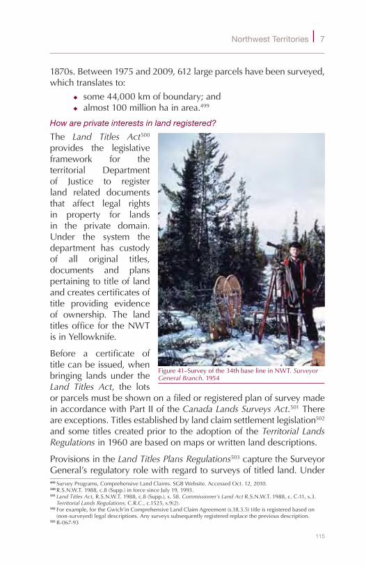
115
Northwest Territories 7
1870s.Between1975and2009,612largeparcelshavebeensurveyed,whichtranslatesto:
◆ some44,000kmofboundary;and◆ almost100millionhainarea.499
How are private interests in land registered?
The Land Titles Act500provides the legislativeframework for theterritorial Departmentof Justice to registerland related documentsthat affect legal rightsin property for landsin the private domain.Under the system thedepartment has custodyof all original titles,documents and planspertainingtotitleoflandandcreatescertificatesoftitle providing evidenceof ownership. The landtitlesoffice for theNWTisinYellowknife.
Before a certificate oftitlecanbeissued,whenbringing lands under theLand Titles Act, the lotsorparcelsmustbeshownonafiledorregisteredplanofsurveymadeinaccordancewithPartIIoftheCanada Lands Surveys Act.501Thereareexceptions.Titlesestablishedbylandclaimsettlementlegislation502andsometitlescreatedprior to theadoptionof theTerritorial Lands Regulationsin1960arebasedonmapsorwrittenlanddescriptions.
ProvisionsintheLand Titles Plans Regulations503capturetheSurveyorGeneral’sregulatoryrolewithregardtosurveysoftitledland.Under499SurveyPrograms,ComprehensiveLandClaims.SGBWebsite.AccessedOct.12,2010.500R.S.N.W.T.1988,c.8(Supp.)inforcesinceJuly19,1993.501Land Titles Act,R.S.N.W.T.1988,c.8(Supp.),s.58.Commissioner’s Land ActR.S.N.W.T.1988,c.C-11,s.3.
Territorial Lands Regulations,C.R.C.,c.1525,s.9(2).502Forexample,fortheGwich’inComprehensiveLandClaimAgreement(s.18.3.5)titleisregisteredbasedon
(non-surveyed)legaldescriptions.Anysurveyssubsequentlyregisteredreplacethepreviousdescription.503R-067-93
Figure41–Surveyofthe34thbaselineinNWT.Surveyor General Branch.1954

116
S u r v e y S , P a r c e l S a n d T e n u r e o n c a n a d a l a n d S
theRegulations aCLS is required to submit a sketchof aproposedsurveytotheSurveyorGeneralwhomaythengiveinstructionstotheCLS.Normallyonly lotorparceldesignationsaregiven. If the landsdealtwith in the survey include territorial orCommissioner’s lands,specificsurveyinstructionsarerequiredsincetheselandsareCanadaLands under the Canada Lands Surveys Act. After the survey andsurveyplaniscompleted,approvalbytheSurveyorGeneralisrequiredbefore it is registered. The Regulations also include provisions forplacing boundary monuments after the plan is registered and forpreparing plans compiled from previous filed or registered plans.SurveysbyCLSsarerequiredforcondominiumsplanstoberegisteredunder the Land Titles Act. Survey requirements are given in theCondominium Act504 and in general instructions. Specific surveyinstructionsarenotrequired.
Planning approvalsare required wherea plan of survey ora descriptive planbeing filed or regis-tered in the landtitles office has theeffect of subdividingor consolidating lotsor other parcels ofland. The Planning Act505istheumbrellalegislation for plan-ning for municipalauthorities. A planofsurveyofthesub-division or consoli-dation, or in some
casesadescriptiveplan,isrequired.506Descriptiveplansareplansoflotsorparcelswheresomeoralltheboundarieshavenotbeendefinedbymonumentsandtheplanhasbeenpreparedfrompriorsurveyplanorotherinformation.507
504R.S.N.W.T.1988,c.C-15.505R.S.N.W.T.1988,c.P-7506Land Titles Act,R.S.N.W.T.1988,c.8(Supp.),s.80(1),s.88.507Land Titles Act,R.S.N.W.T.1988,c.8(Supp.),s.1,Definitions.
Figure42–GoingovernotesinasurveycampontheNWT/Saskatchewanboundary.Surveyor General Branch.1956
117
Northwest Territories 7
ThereisprovisionintheLand Titles ActfortheRegistrartodealwithandrecognizeplanspreparedandsenttotheRegistrarinaccordancewiththeprovisionsofanActofCanada.508ThisprovisionpermitsthefilingofplansoflandintheNWTsenttotheRegistrarunderSections30and45oftheCLS Act.
What is the role of the Surveyor General Branch in Yellowknife?
Surveys ofCanada Lands in theNWTaremade under theCanada Lands Surveys ActonarequestofaministerofanydepartmentoftheGovernmentofCanadaoraCommissioneradministeringthelands.509TheSurveyorGeneralBranch (SGB) inYellowknifeprovidesawiderangeofadviceandconsultationservicesonsurveyrelatedmatterstoINAC,other federal governmentdepartments, territorial governmentdepartments,AboriginalorganizationsandCLSs.TheCadastralSurveysUnitoftheSGBregulatessurveysintheNWTandNunavutbyissuingsurveyinstructions,providinglotnumbers,reviewingandprocessingsurveyplans,reviewinglanddescriptionsfortransfersofadministrationandcontrolandforordersincouncil.TheLandClaimsUnitmanagesthesurveyprogramsintheNWTandNunavut,thelargestofwhicharesurveysofsettlementlands.
What is the quad lot system?
Outsideofcommunities,surveyedparcelshavebeenindexedtoquadlots since1977.Aquad is the area of landdepictedon a 1:50,000National Topographic Series (NTS) map. Every parcel surveyed isgiven a sequential numberwithin the quad. The quad number (the1:50,000NTSmap sheet number) forms part of the parcel designa-tion.Thesequentiallotnumbersforquadlots(andforlotsandblocksincommunities)areissuedbytheSurveyorGeneralBranch’sregionalofficeinYellowknife.Lotnumberingwithineachquadstartsat1000toavoidanyconfusionwithpriorlotnumberingsystems.ThequadlotsystemisalsousedinYukonandNunavut.
Prior to the quad lot system, group lot systemswere used to indexsurveys.UnderthefirstgrouplotsystemalloftheNWTwasregardedasGroup1.Lotssurveyedinthisgroupwerenumberedsequentiallyupwards from one as they were created. Eventually, this systembecameverycumbersome.InalatervariationtheNWTwasdividedintogroupsbasedonthe(unsurveyed)DLSsurveysystem.Eachgroupwaseighttownships(48miles)inlatitudeandfifteenranges(120miles)
508Land Titles Act,R.S.N.W.T.1988,c.8(Supp.),ss.103-105.509Canada Lands Surveys Act,R.S.C.1985,c.L-6,s.25
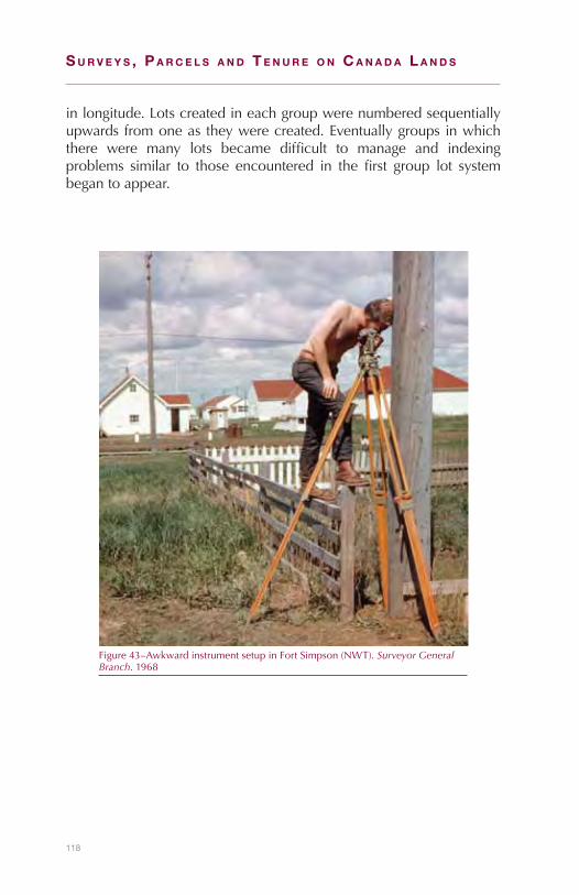
118
S u r v e y S , P a r c e l S a n d T e n u r e o n c a n a d a l a n d S
inlongitude.Lotscreatedineachgroupwerenumberedsequentiallyupwardsfromoneastheywerecreated.Eventuallygroupsinwhichthere were many lots became difficult to manage and indexingproblems similar to those encountered in the first group lot systembegantoappear.
Figure43–AwkwardinstrumentsetupinFortSimpson(NWT).Surveyor General Branch.1968

119
Northwest Territories 7
ActsandregulationrelatingtolandsinNWT
TypeofTransaction SurveyRequirements(StatutoryorotherAuthority)
TERRITORIALLANDSSURFACERIGHTS
Sales(feesimple) Territorial Lands Regulations. s.9.1.MINESANDMINERALS
Mineralclaimleases NWT and Nunavut Mining Regulations,s.54-57surveys,s.53.(2)(b)disputes.
Dredgingleases Territorial Dredging Regulations,s.8OILANDGAS
Exploratorywellsanddevelopmentwells,
Canada Oil and Gas Land Regulations,ss.10-22.
COMMISSIONER’SLANDTransferofadministrationofCommissioner’slandtoamunicipalcorporation
Commissioner’s Land Act.s.3(3).
Sales Commissioner’s Land Act.s.3(3).Territorial Lands Regulations,s.9(1)(2).
TITLEDLANDIssuanceoftitleonreceivingagrant(notification)
BoththeCommissioner’s Land ActandtheTerritorial Lands RegulationsrequirethataplanofsurveybefiledorregisteredintheLandTitlesoffice.
RegistrationoftitleinnameofHerMajestyinrightofCanadaortheCommissioner
Land Titles Act,s.58.
OthersurveysundertheLandTitlesAct.
Land Titles Act,ss.80-106.Land Titles Plans Regulations
CondominiumSurveysundertheCondominiumAct
Condominium Act,s.6
SETTLEMENTLANDSSettlementlandsregisteredinthelandtitlesoffice.
ProvisionintheLand Titles ActandLand Titles Plan Regulationsapply.LandsinwhichthefeesimpleinterestisvestedintheTlichogovernmentareCanadaLands.

S u r v e y S , P a r c e l S a n d T e n u r e o n c a n a d a l a n d S
120
121
8Nunavut
What are Canada Lands in Nunavut?
Nunavut(theInuktitutwordfor“ourland”)isthelargestandnewestterritory of Canada. It has an area of twomillion square km and apopulation of 30,000 people, ofwhom85% are Inuit.510 The landsand resources are managed by the Government of Canada, theGovernment of Nunavut, the Nunavut Tungavik Incorporated (NTI)andthreeRegionalInuitAssociations(RIAs).MostoftheCanadaLandsinNunavutareterritoriallandsundertheadministrationandcontrolofthefederalGovernment.OtherCanadaLandsincludeCommissioner’slandswhich,even though theCommissionerhasadministrationandcontrolofthem,areCanadaLandsbecausetheyremainvestedinHerMajestyinrightofCanada.511
What events led to the establishment of Nunavut?
ThelandareaoftheMackenzieandtheEasternArcticisalandoftwodistinctphysicalgeographicareasandpeoples.TheeastisanalmosttreelessregionwheremostofthepeopleareInuit.ItwasnaturalthatthisdivisionwouldformthebasisforlandclaimsettlementareasandthecreationoftheseparateterritoryofNunavutin1999.
The Northwest Territories (NWT) council discussed division in theearly1960’swhichledtotheintroductionofabillin1963tocreatetwoterritories.However,therewaslittlesupport.In1966theCarrothersCommission, setup to study the futureof government in theNWT,
510Our Land:GovernmentofNunavutWebsite.AccessedOct.12,2010.511Nunavut Act,S.C,1993,c.18,s.49(1),Canada Lands Surveys Act,R.S.C.1985,c.L-6,s.24(1)(a).

122
S u r v e y S , P a r c e l S a n d T e n u r e o n c a n a d a l a n d S
concludedthatwhiledivisionwasprobably inevitable,discussionoftheideashouldbedelayedfortenyears.ItstatedthattheInuitwouldbeisolated,withlittleifanypoliticalpower,ifdivisionwerecarriedoutimmediately.
In 1982, a territory-wide plebiscite sup-ported division.512After the TungavikFederation of Nuna-vut (TFN), acting onbehalfof the InuitofNunavut, and gov-ernment agreed onthe location of theboundary, anotherplebiscite approvedit in May 1992.513The establishmentof anew territoryofNunavutanditsgov-
ernmentwasassuredin1993whenParliamentgaveitsassenttotheNunavut Act.514TheActcameintoforceonApril1,1999,creatingtheterritoryofNunavut.
How did the Inuit land regime evolve?
In1971theInuitTapirisatofCanada(ITC)wasformedandbegantalkswiththefederalgovernmentaboutAboriginalrights:
Explaining to the older generation why it was necessaryto “claim”ourhomelandwasnot an easy task. The Inuitleadership also had to face hostile governments anda Canadian population largely ignorant of Inuit, theirhomeland, and their history. Inuit negotiators also had tobreaknewground in their landclaim talks.GovernmentsdidnothaveanypolicyinmanyareasthatInuitfelthadtobepartofanyfinaldeal.515
512Towards Confederation, Provinces and Territories, Nunavut Entered Confederation: 1999:LibraryandArchivesCanadaWebsite.AccessedOct.12,2010.
513The Road to Nunavut: A Chronological History:GovernmentofNunavutWebsite.AccessedOct.12,2010.514Nunavut ActS.C.1993,c.28,s.79(1)515JohnAmagoalik,Nunavut 99 - What Price Nunavut: Website.AccessedOct.12,2010.
Figure44–SurveyingaroundracksusedtodrymeatinGriseFiord(Nunavut).Surveyor General Branch.1968

123
Nunavut 8
AlandclaimpresentedbyITCtothefederalgovernment,earlyin1976,wasaccepted fornegotiation.516 In1982, theTungavikFederationofNunavut(TFN)wascreatedtopursuethenegotiationsonbehalfoftheInuitofNunavut. InNovember1992, the InuitbypetitionapprovedtheAgreementbetweentheInuitoftheNunavutSettlementAreaandHerMajestytheQueeninRightofCanada(NunavutAgreement).InDecember1993itwasratifiedbytheNunavut Land Claims Agreement Act.517Under theNunavutAgreement the Inuitceded, releasedandsurrendered“alltheiraboriginalclaims,rights,titleandinterestsinandto landsandwatersanywherewithinCanadaandadjacentoffshoreareaswithinthesovereigntyofCanada.518Inexchangetheyobtaineddefinedrightsandbenefitssuchassubsurfaceandsurfacetitletocertainland,therighttoparticipateindecision-makingconcerningland,waterandresources,harvestingrightsandfinancialcompensation.
TFNwassucceededbytheNTIin1993.519NTI,locatedinIqaluit(theexecutive) and Cambridge Bay (the lands and resources people) isresponsibleforensuringthattheNunavutAgreementisimplementedfullybytheGovernmentsofCanadaandNunavutandthatallpartiesfulfill theirobligations. Ithasassumedaverybroadmandate for theInuit fostering economic, social and cultural well-being.520 NTI hasdesignated the RIAs; the Qikiqtani (formally Baffin Regional) InuitAssociationinIqaluit,theKivalliqInuitAssociationinRankinInlet,andtheKitikmeotInuitAssociationinCambridgeBaytoprovidethelinktoNunavutcommunitiesandtocarryoutsomeoftheobligationsundertheNunavutAgreement.521
What is being done to protect the land and resources?
Because there is only one comprehensive land claim agreement inNunavuttheregulatoryregimeforprotectinglandandresourceisnotascomplexasthatfortheNWT.TheNunavutImpactReviewBoard,establishedunderArticle12oftheNunavutAgreement,isresponsiblefor the environmental assessment of projects.522 Other institutionsrelatedtolandandresourcesestablishedundertheNunavutAgreementincludetheNunavutPlanningCommission,theNunavutWaterBoard
516KeithCrowe,Nunavut 99 - The Road to Nunavut.Website.AccessedOct.12,2010.517S.C.1993,c.29,s.4(1).AssentedtoonJune10,1993andcameintoforceonDecember,31,1993.518AgreementbetweentheInuitoftheNunavutSettlementAreaandHerMajestytheQueeninRightofCanada
(NunavutAgreement),s.2.7.1(a).519NTIistheorganizationrepresentingtheInuitintheNunavut Act,S.C.1993,c.28.520AboutNTI,ProgramsandBenefits:NunavutTunngavikIncorporated(NTI)Website.AccessedOct.12,2010.521NTIOrganizationalChart,AboutNTI.NunavutAgreement,Article39.1.3522NunavutAgreement,Article12.ClarificationthattheCanadian Environmental Assessment Actdoesnotapply
wasprovidedbyanamendmenttotheNunavutAgreementbyOrderinCouncil2008-977.TheprocesstoamendtheNunavutAgreementisgiveninArticle.2.13.1oftheAgreement.
124
S u r v e y S , P a r c e l S a n d T e n u r e o n c a n a d a l a n d S
andtheNunavutWildlifeManagementBoard.NTIandthethreeRIAsare representedon thesebodies,andparticipate indecisionmakingandpolicydevelopment.
What is the status of devolution?
The government of the NWT had gained considerable control ofresponsibilities from the federal government prior to the creationofNunavutandtheseresponsibilitieswereassumedbythenewterritorialgovernment ofNunavut. Aswell, considerable responsibilitieswereobtained by the Inuit under the Nunavut Agreement. After 1993,federalandterritorialgovernmentsandInuitorganizationswerefullyoccupied in implementing policies and programs and establishingnewhighlydecentralizedorganizations tocarryout thegoalsof theNunavutAgreementandtheNunavut Act.523
InSeptember2008,aProtocolagreementfordevolutionwassignedbytheMinisterofIndianandNorthernAffairsCanada(INAC),thePremierofNunavut, and thePresidentofNTI. It is to serveasa frameworktoguideall threeparties in futuredevolutionnegotiations. Includedare onshoreCrown lands,mineralmanagement and a commitmentto discuss oil and gas resource management at a future phase ofnegotiations.524
Are there any differences in the management of Territorial lands from the NWT?
Notreally.ProvisionsintheNunavut ActregardinglandaresubstantiallysimilartothoseintheNWTActexceptforsomeadditionsrequiredtoenablecertainlawsoftheNWTtoapplytoNunavutandforthetransferofadministrationandcontroloflandsinNunavuttotheCommissionerofNunavut.TheTerritorial Lands Act525andtheRegulationsundertheAct for surface lands,mineralsandoilandgascontinue toapply inNunavutasintheNWT.
How are surface rights of territorial lands managed?
The LandAdministrationOfficeof INAC in Iqaluitmanages surfaceland activities on territorial lands (including disposition of surfacerights)andmaintainstheLandAdministrationRegistry,whichcontainsleases,permitsandotherinstrumentsofterritoriallandsinNunavut.526
523MikeVlessides,Nunavut 99 - A Public Government:Website.Accessed.Oct.12,2010.524LandsandResourcesDevolutionNegotiationProtocol;INACWebsite.AccessedOct.12,2010.525R.S.C.,1985,c.T-7526NunavutRegionalOffice,LandandEnvironment,LandAdministration:INACWebsite.AccessedOct.12,
2010.A“SpatiallyIntegratedDataset”(SID)isalsoaccessibleonlinethatcontainsinformationonINACdispositions.
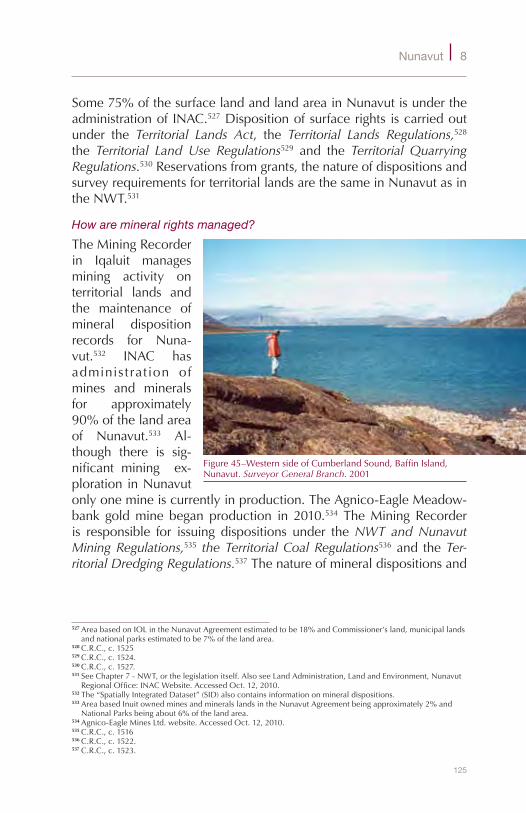
125
Nunavut 8
Some75%ofthesurfacelandandlandareainNunavutisundertheadministrationofINAC.527Dispositionofsurfacerightsiscarriedoutunder the Territorial Lands Act, the Territorial Lands Regulations,528 the Territorial Land Use Regulations529 and the Territorial Quarrying Regulations.530Reservationsfromgrants,thenatureofdispositionsandsurveyrequirementsforterritoriallandsarethesameinNunavutasintheNWT.531
How are mineral rights managed?
TheMiningRecorderin Iqaluit managesmining activity onterritorial lands andthe maintenance ofmineral dispositionrecords for Nuna-vut.532 INAC hasadminis t rat ion ofmines and mineralsfor approximately90%ofthelandareaof Nunavut.533 Al-though there is sig-nificant mining ex-plorationinNunavutonlyonemineiscurrentlyinproduction.TheAgnico-EagleMeadow-bank goldmine began production in 2010.534 TheMiningRecorderis responsible for issuing dispositions under theNWT and Nunavut Mining Regulations,535 the Territorial Coal Regulations536and theTer-ritorial Dredging Regulations.537Thenatureofmineraldispositionsand
527AreabasedonIOLintheNunavutAgreementestimatedtobe18%andCommissioner’sland,municipallandsandnationalparksestimatedtobe7%ofthelandarea.
528C.R.C.,c.1525529C.R.C.,c.1524.530C.R.C.,c.1527.531SeeChapter7-NWT,orthelegislationitself.AlsoseeLandAdministration,LandandEnvironment,Nunavut
RegionalOffice:INACWebsite.AccessedOct.12,2010.532The“SpatiallyIntegratedDataset”(SID)alsocontainsinformationonmineraldispositions.533AreabasedInuitownedminesandmineralslandsintheNunavutAgreementbeingapproximately2%and
NationalParksbeingabout6%ofthelandarea.534Agnico-EagleMinesLtd.website.AccessedOct.12,2010.535C.R.C.,c.1516536C.R.C.,c.1522.537C.R.C.,c.1523.
Figure45–WesternsideofCumberlandSound,BaffinIsland,Nunavut.Surveyor General Branch.2001

126
S u r v e y S , P a r c e l S a n d T e n u r e o n c a n a d a l a n d S
surveyrequirementsforterritoriallandsarethesameinNunavutasintheNWT.538
How are oil and gas rights managed?
INAChasadministrationofoilandgasrightsforapproximately90%ofthelandinNunavut.CurrentlythereisnooilandgasproductioninNunavut,partiallyowingtothehighcostsofdevelopment.However,there is tremendous potential. Estimates place the reserves in theSverdrupBasin,westofDevonIsland,at11percentofCanada’stotalcrudeoilresourcesand20percentofCanada’snaturalgasresources.539
The same statutoryregime in the NWTappliestooilandgasinterests and oper-ations in Nunavut.Under the Canada Petroleum Resources Act540 interests aremanaged by INACand under the Can-ada Oil and Gas Operations Act541oiland gas operationsare managed bythe National EnergyBoard. Registration
ofoilandgasinterests,thenatureofdispositionsandsurveyrequire-mentsarethesameinNunavutasintheNWT.542
Did the Nunavut Act result in changes to the management of Commissioner’s lands?
There was little change to the land management system forCommissioner’s lands. The laws and regulations of the NWT were“duplicatedtotheextentthattheycanapplyinrelationtoNunavut,withanymodifications that thecircumstances require.”543Over200ActsoftheNWTwereamendedoradoptedwithlittlechange.538SeeChapter7-NWT,orthelegislationitself.AlsoseeNunavutRegionalOffice,LandandEnvironment,
MiningRecordersOffice:INACWebsite.AccessedOct.12,2010.539OilandGas,DepartmentofEconomicDevelopment&Transportation:LookUpNunavut,Website.Accessed
Oct.12,2010.540R.S.C.,1985,c.36541R.S.C.,1985,c.O-7.542SeeChapter7-NWT,orinthelegislationitself.543Nunavut Act,S.C.1993,c.28,ss.29,76.
Figure46–HelicopterinAkbatBay,BaffinIsland.Surveyor General Branch.2000

127
Nunavut 8
The Community Planning and Lands Section of the Departmentof Community and Government Services in Kugluktuk managesCommissioner’slands544includingthedispositionofsurfacerightsandmaintenance of a lands registrywhich contains leases, permits andother instruments of Commissioner’s lands. Commissioner’s AirportlandsaremanagedbytheDepartmentofEconomicDevelopmentandTransportation.
GenerallythesameprovisionsapplyinNunavutregardinglandinterestsandlandsurveysasapplyintheNWT.UndertheCommissioner’s Land Act (Nunavut)545theCommissionermayuse,sellorotherwisedisposeof Commissioner’s land and retain the proceeds.546 Sections of theTerritorial Lands Act thatdealwithnotificationoftitleandreservationsfromgrantsapplytosales.547TheCommissioner’s Land Regulations548also have provisions applying to the sale of Commissioner’s landsalongwithprovisionsforleasing.ThenatureofdispositionsandsurveyrequirementsforCommissioner’slandsinNunavutarethesameasintheNWT.549
To what extent are municipalities affected by the Nunavut Agreement?
TheNunavutAgreementhasprovisionsthatsupportstrongmunicipalitiesthrough the transfer of lands to 25 municipal corporations.550 TheNunavutAgreement requires that theCommissioner convey the feesimple landswithinamunicipality’sbuilt-upareaand subsequently,on request, convey surveyed landwithin themunicipal boundariesto the municipal corporation.551 Certain lands are excluded fromthe conveyance including beds ofwater bodies and landswithin a100footstripalongtheshoreline.TheCommissionercannotalienateor create any interest in this strip without the permission of themunicipalcorporation.552Onceconveyedand registered in the landtitlesoffice,themunicipalitymayuse,hold,developordisposeofthelands.553 However, the territorial government held a referendum onApril 10,1995 todetermine ifmunicipal voterswere in favourof a
544CommunityPlanningandLands:DepartmentofCommunityandGovernmentServices,Nunavut.545R.S.N.W.T.1988,c.C-11.546R.S.C,1985,c.N-27,s.44(2);R.S.N.W.T.1988,c.C-11,s.3.547R.S.C.,1985,c.T-7.ss.3(2),s.9,12-16,23(k).548R.R.N.W.T.1990,c.C-13549SeeChapter7forafulsomediscussion.Or,seeNunavutRegionalOffice,LandandEnvironment,Land
Administration:INACWebsite.AccessedOct.12,2010.550Nunavut Agreement,Schedule14-1,p.134.551Nunavut Agreement,Article14.3.1,14.3.2.Alsosee:Book Three, NWT Nunavut Settlement Area Lands,
Jurisdictional Responsibilities for Land Resources, Land Use and Development in the Yukon Territory and NWT, 1997,s.3.5.1.
552Nunavut Agreement,Article14.1.1.(b)(ii),14.5.2.553Cities, Towns And Villages Act (Nunavut),R.S.N.W.T.1988,c.C-8,s.53.4.Hamlets Act (Nunavut),R.S.N.W.T.
1988,c.H-1,s.53.4.
128
S u r v e y S , P a r c e l S a n d T e n u r e o n c a n a d a l a n d S
20-yearrestrictiononalienationofmunicipallands.Withoutexception,alease-onlyoptionwaschosenbyallmunicipalities.554
What is the Nunavut Settlement Area?
TheNunavutsettlementarea includesanAreaAandAreaBwhicharedescribedinArticle3oftheNunavutAgreement.AreaAincludesaportionoftheArcticIslandsandmainlandoftheEasternArcticandadjacentmarineareas,AreaBincludestheBelcherIslands,associatedislandsandadjacentmarineareasinHudsonBay.TheInuithavearightofaccess toharvestandtoparticipate inplanninganddevelopmentwithinthewholesettlementarea.Restrictionstoharvestingarefew;forexample,theInuitarenotabletoharvestonprivatelands(landsheldinfeesimple)oronleasedlands.555
What are Inuit Owned Lands?
InuitOwned Lands (IOL) are the lands towhich the Inuit receivedfeesimpletitle.Theyreceivedapproximately37,000squarekilometresof land in fee simple, including surface and sub-surface rights; and315,000squarekmoflandinfeesimpleofsurfacerightsonly.556Thetotalsurfacearearepresentsapproximately18%oftheareaofNunavut.
NTIhasdesignatedthethreeRIAsastitleholdersofthesurfaceIOLineachoftheirregions.EachRIAhaspoliciesandproceduresforthedispositionofsurfacelandrights.557MineralrightsforallIOLareheldandadministeredbyNTI.NTIgrantsamineralexplorationagreementand a mineral production lease through its own mineral tenureregime.558NTIalsoholdsandadministersoilandgasrights.
Forsub-surfacedevelopmentofIOLlandstowhichtheRIAonlyhastitletothesurface,therighttooccupyandusesurfacelandsforroads,camps, andother surfaceactivitiesmustbeobtained from theRIA.Inthecaseofdisputesregardingaccess, theNunavutSurfaceRightsTribunal can authorize use and occupation of land and determinecompensationforsurfacelandrightholders.559
5541995–1996AnnualReportontheImplementationoftheNunavutLandClaimsAgreement,p.18.555NunavutAgreement,Articles5.7.16-5.7.22.556Book Three, NWT Nunavut Settlement Area Lands,Jurisdictional Responsibilities for Land Resources, Land Use
and Development in the Yukon Territory and NWT, 1997,s.3.3.1.3.557Forexamplesee:GuidetoApplyingforInuitOwnedLandSurfaceRights,KitikmeotInuitAssociation.558Nunavut,Overview,2008,MineralExploration,MiningandGeoscience,INAC.559Nunavut Waters and Nunavut Surface Rights Tribunal Act,2002,c.10,NunavutAgreement,Article21.

129
Nunavut 8
Are there other comprehensive land claim agreements in Nunavut?
TheNunavutAgreementcoversmostoftheareaofNunavut.However,the2006NunavikInuitLandClaimsAgreement560withtheNunavikInuit,who inhabit theNorthern regionofQuébec,overlapsa smallportion of the Inuit of Nunavut settlement area. Both the NunavutAgreement and the Nunavik Agreement includes arrangements forcontinuationofharvestingand jointownershipof lands traditionallyusedandoccupiedbybothgroups.561
What are the requirements for the survey of boundaries of Inuit Owned Lands?
The provision in the Nunavut Agreement for the preparation ofdescriptive map plans for IOL initially alleviated the urgency forlegalsurveysnormallyassociatedwitha large landclaimsettlementagreement.SurveysundertheCLS Actwerestillrequired:
◆ to avoid or resolve conflicts with another title or interestholder;
◆ foranypurposeatGovernment’sdiscretion;◆ todefineboundariesofCrownlandstobeexcludedfromIOL;and
◆ todefineboundariesofIOLwithinmunicipalboundaries.562
The government and NTI agreed that descriptive map plans wereinadequate and that all parcels should be surveyed using isolatedboundarystandards,whichallowedforlessfrequentmonumentation.A10-yearprogram tosurvey1,155parcelsof IOLbegan in1994,563andhas resulted in some105,000 kmof boundary, and an areaof190 million hectares, being surveyed.564 As of 2009, most of thesurveyshavebeencompleted565withapproximately75%oftheplansregisteredintheLandTitlesOffice566andtheremaindergoingthroughtheregulatoryprocess.
What is the system for registering private interests in land?
Private lands inNunavut are registered in the Land TitlesOffice inIqaluit and administered under the Land Titles Act (Nunavut)567 bythe Nunavut Department of Justice. Other legislation, such as the
560RatifiedbytheNunavik Inuit Land Claims Agreement Act,2008,c.2.561NunavutAgreement,Article40andNunavikInuitLandClaimsAgreement,Article27.562Nunavut Agreement,Article19.8.8.,19.8.11andschedules19-12,19-13.563Ballantyne&Strack.Property Rights Study for Nunavut,NRCan.2003,p.7.564SurveyPrograms,ComprehensiveLandClaims.SGBWebsite.AccessedOct.12,2010.565DavidRochette,HeadNunavutClientLiaison,SGB,Telecon:Nov.30,2009566StanHutchinson,NunavutLandSpecialist,INAC,January08,2010.567R.S.N.W.T.1988,c.8.
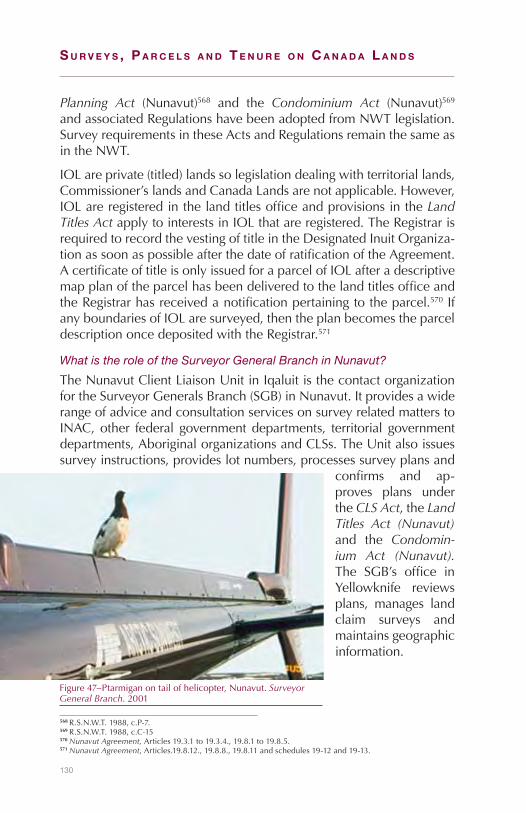
130
S u r v e y S , P a r c e l S a n d T e n u r e o n c a n a d a l a n d S
Planning Act (Nunavut)568 and the Condominium Act (Nunavut)569andassociatedRegulationshavebeenadoptedfromNWTlegislation.SurveyrequirementsintheseActsandRegulationsremainthesameasintheNWT.
IOLareprivate(titled)landssolegislationdealingwithterritoriallands,Commissioner’slandsandCanadaLandsarenotapplicable.However,IOLareregisteredinthelandtitlesofficeandprovisionsintheLand Titles Act applytointerestsinIOLthatareregistered.TheRegistrarisrequiredtorecordthevestingoftitleintheDesignatedInuitOrganiza-tionassoonaspossibleafterthedateofratificationoftheAgreement.AcertificateoftitleisonlyissuedforaparcelofIOLafteradescriptivemapplanoftheparcelhasbeendeliveredtothelandtitlesofficeandtheRegistrarhasreceivedanotificationpertainingtotheparcel.570IfanyboundariesofIOLaresurveyed,thentheplanbecomestheparceldescriptiononcedepositedwiththeRegistrar.571
What is the role of the Surveyor General Branch in Nunavut?
TheNunavutClientLiaisonUnitinIqaluitisthecontactorganizationfortheSurveyorGeneralsBranch(SGB)inNunavut.ItprovidesawiderangeofadviceandconsultationservicesonsurveyrelatedmatterstoINAC,other federal governmentdepartments, territorial governmentdepartments,AboriginalorganizationsandCLSs.TheUnitalsoissuessurveyinstructions,provideslotnumbers,processessurveyplansand
confirms and ap-proves plans undertheCLS Act,theLand Titles Act (Nunavut)and the Condomin-ium Act (Nunavut). The SGB’s office inYellowknife reviewsplans, manages landclaim surveys andmaintainsgeographicinformation.
568R.S.N.W.T.1988,c.P-7.569R.S.N.W.T.1988,c.C-15570Nunavut Agreement,Articles19.3.1to19.3.4.,19.8.1to19.8.5.571Nunavut Agreement,Articles.19.8.12.,19.8.8.,19.8.11andschedules19-12and19-13.
Figure47–Ptarmiganontailofhelicopter,Nunavut.Surveyor General Branch.2001
131
9Yukon
What are Canada Lands in Yukon?
StoriesoftheKlondikegoldrush,JackLondon’snovelsandthepoemsofRobertServicehaveallcontributed to the fascinationthatpeoplehavewithYukon.Yukonhasanareaof483,450km2andapopulationof 34,000 people, 26% of whom are Aboriginal.572 The lands andresourcesaremanagedbytheYukonGovernmentandbyYukonFirstNationGovernments(YFNs).EventhoughmostofthelandsinYukonareundertheadministrationandcontroloftheCommissioneroftheYukon they are Canada Lands because they remain vested in HerMajestyinrightofCanada.573OtherCanadaLandsincludesettlementlandsasdefinedintheYukon First Nations Self-Government Act574 andlandheldbytheGovernmentofCanadaforgovernmentdepartmentsandforpublicpurposes(suchasnationalparks).
How did the land management system evolve?
At the peak of the Klondike gold rush in 1898 the Parliament ofCanadapassedtheYukon Territory Act 575whichestablishedYukonasaseparateterritoryfromtheNorth-WestTerritories(NWT).UndertheActaCommissionerinCouncilwasgrantedthesamepowerstomakeordinancesaswaspossessedbytheLieutenantGovernoroftheNorth-WestTerritories.576LegislationsuchastheDominion Lands Act577and
572(2008)YukonBureauofStatistics.YukonFactSheet.573Yukon Act,S.C.2002,c.7,s.Interpretation2,definitionofpublicrealproperty.AlsothepriorYukon ActR.S.C,
1985,c.Y-2,s.47.574Canada Lands Surveys Act,R.S.C.1985,c.L-6,s.24.575S.C.1898,c.6.576MaryC.Hurley.BillC-39,TheYukon Act,2002,ParliamentaryResearchBranch,LibraryofParliament.577S.C.1872,c.23.

132
S u r v e y S , P a r c e l S a n d T e n u r e o n c a n a d a l a n d S
The Territories Real Property Act continued toapply toYukon.578 In1908,theDominion Lands Act579ceasedtoapplytoYukon;however,the newDominion Lands Surveys Act,580 applied to public lands inYukon.581
By1950,anewTerritorial Lands Act582 appliedtoYukon.ChangeswerealsomadetotheYukon ActwhichincludedgrantingtheCommissionerinCouncilgreaterresponsibilitiesoneofwhichwas theauthority toholdlandforterritorialpurposessuchasforpublicbuildings,schools,hospitals, roadsandotherworks.583These landsbecamecommonlyknownasCommissioner’sLands.
578S.C.1886,c.26.ItwasfeltatthetimethatprovisionsintheActwerenotapplicabletotheYukon.Debates,HouseofCommons,March14,1907,pp.4643,4644.
579S.C.1908,c.20.580S.C.1908,c.20.s.4.2.S.C.1908,c.21.Debates,HouseofCommons,February15,1907,p.3093581S.C.1908,c.21,s.3.S.C.1908,c.20,ss.3,5.582S.C.1950,c.22.583S.C.1953,c.53,s.45.Debates,HouseofCommons,April1,1953,p.3510.
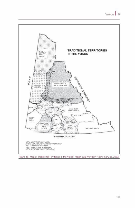
133
Yukon 9
TRADITIONAL TERRITORIESIN THE YUKON
NO
RTHW
EST TERR
ITOR
IES
ALA
SK
A
BRITISH COLUMBIA
WRFN - WHITE RIVER FIRST NATIONLS/CFN - LITTLE SALMON/CARMACKS FIRST NATIONTKC - TA’AN KWACH’AN COUNCILKDFN - KWANLIN DUN FIRST NATIONC/TFN - CARCROSS/TAGISH FIRST NATION
FIRST NATION OFNACHO NYAK DUNTR’ONDËK
HWËCH’IN
SELKIRK FIRST NATION
WRFN
KLUANEFIRSTNATION
CHAMPAGNEand AISHIHIK
FIRSTNATIONS
TKC
LS/CFN
KDFN
C/TFN
ROSS RIVERDENA COUNCIL
TESLINTLINGIT
COUNCIL LIARD FIRST NATION
VUNTUTGWITCHINFIRSTNATION
Figure48–MapofTraditionalTerritoriesintheYukon.Indian and Northern Affairs Canada.2002

134
S u r v e y S , P a r c e l S a n d T e n u r e o n c a n a d a l a n d S
What is the status of devolution?
The devolution of federal responsibilities to territorial governmentsbecame a priority in the 1980s. Landmanagement responsibilitiestransferred since then include fisheries, intra-territorial roads andoil and gas.584 The process and responsibilities in carrying out thelatest transferwas provided in the YukonNorthern Affairs ProgramDevolution Transfer Agreement signed by Canada, Yukon and theCouncilofYFNsin2001.Withthecomingintoforcein2003oftheYukon Act,585 Yukon obtained administration and control of publiclandinYukon,includingminesandminerals,waterandanareaofoilandgas,calledtheadjoiningarea,whichislandwardoftheordinarylowwatermarkofthenortherncoastincludingcoastalindentations.586
What lands remain with the Government of Canada?
UndertheYukon ActtheGovernorinCouncilwasrequiredtolistpublicrealpropertythatisexcludedfromtheadministrationandcontroloftheCommissioner.Over300parcelsoflandareexcludedandremainundertheadministrationofvariousdepartmentsoftheGovernmentofCanada,mainlyforgovernmentoperations.Aswell,CanadaretainedadministrationandcontrolofKluaneNationalPark,KluaneNationalParkReserve,IvvavikNationalParkandVuntutNationalParkandtheNisutlinRiverDeltaNationalWildlifeArea.587
There is also provision in the Yukon Act for the future takingof administration and control of public real property from theCommissionerifsuchtakingisinthenationalinterest.Suchinterestsincludenationaldefence,establishingorchangingtheboundariesofnationalparksorhistoric sites, thewelfareof Indiansand Inuit,andsettlingAboriginallandclaims.588
What lands are managed by the Yukon Government?
Since the transfer of lands and resources in 2003 there are twocategories of Canada Lands in Yukon under the administration andcontroloftheCommissioneroftheYukon:
584MaryC.Hurley.BillC-39,LegislativeSummary,theYukon Act,2002,ParliamentaryResearchBranch.OilandgaswastransferredbytheCanada-Yukon Oil and Gas Accord Implementation ActS.C.1998,c.5.TheactualtransferoccurredbyPC1998-2022,November19,1998.
585S.C.2002c.7.586Yukon Act,S.C.2002c.7,s.2definitionofpublicrealproperty,s.45(1),48.Theadjoiningareaisdefinedins.2
definitionsandinSchedule2.587Yukon Act,S.C.2002c.7,s.45(2),PC2003-397.CarcrossIndianReserveNo.4wasalsoincludedinthelistof
retainedland(p.4);however,pursuanttoOrder-inCouncilSOR/2005-403undertheYukon First Nations Self-Government Act,1994,c.35,s.5(2)andtheCarcross/TagishFirstNationSelf-GovernmentAgreement,2005,s.29theReservebecameCategoryASettlementLands.
588Yukon Act,S.C.2002c.7,s.49(1).
135
Yukon 9
1. Yukon lands589 (lands known as Commissioner’s lands priortoApril 1, 2003) are landswhose beneficial use or proceedsare appropriated to the Yukon Government. These lands areregulatedbytheLands Act,590andtheLands Regulations,Quarry Regulations and Grazing Regulations.591 Yukon lands do notincludeterritoriallands
2. Territoriallands592(commonlyknownasCrownlands593)arelandsundertheadministrationandcontroloftheCommissioneronorafterApril1,2003.Theselandsareregulatedbythe Territorial Lands (Yukon) Act,594andtheTerritorial Lands Regulation,Land Use Regulation,Coal Regulation,andtheDredging Regulation.595ThisActmirrorsthefederalTerritorial Lands Act.
Tofacilitatelandadministrationa2003amendmenttotheLands ActprovidedthatYukonlandsmaybedealtwithasterritoriallandsunderthe Territorial Lands (Yukon) Act.596 For example, Order-in-Council2003/151specifies thatsectionsof theTerritorial Lands (Yukon) Act,dealingwith sales and leasing, apply to allYukon lands.597Aswell,underOrder-in-Council2003/77theLand Use Regulationapplies toallYukonlands.598
How are surface rights managed?
TheLandBranchoftheDepartmentofEnergyMinesandResources,Yukon Government administers most surface land activities onterritoriallandsincludingdispositionofsurfacerightsandmaintenanceofalandsregister.599TheAgricultureBranchdealswiththedispositionoflandforagricultureorgrazingpurposes.Approximately85%ofthesurfacelandareainYukonisundertheadministrationandcontroloftheYukonGovernment.600
589Lands Act,R.S.Y.2002,c.132,ss.Interpretation1,2(1).590R.S.Y.2002,c.132.AnamendmentmadebytheTerritorial Lands (Yukon) Act,2003,c.17,s.33(2)toR.S.Y.
2002,c.132,s.2.1excludedterritoriallandsfromthelandsthattheLands Actappliesto.591Y.O.I.C.1983/192;Y.O.I.C.1983/205,2003/76,2005/38,2006/124;Y.O.I.C.1988/171.592Territorial Lands (Yukon) Act,S.Y.2003,c.17,ss.Definitions,1,2(1).593ColinBeairsto,LandsBranch,YukonGovernment.Telecon:January12,2010.594S.Y.2003,c.17.595Y.O.I.C.2003/50,Y.O.I.C.2003/51,Y.O.I.C.2003/54,Y.O.I.C.2003/55.596SeeTerritorial Lands (Yukon) Act,S.Y2003,c.17,s.33(2).AdditionmadetoLands (Yukon) Act,R.S.Y.2002,c.
132:ss.2(1),2(3,4).Lands (Yukon) Act,R.S.Y.2002,c.132.597Y.O.I.C.2003/151.“Forthepurposesofsections7and10to14andparagraph21(k)oftheTerritorial Lands
(Yukon) Act,allYukonlandsshallbedealtwithasterritoriallandsundertheTerritorial Lands (Yukon) Act.”598Y.O.I.C.2003/77.“TheLand Use RegulationappliestoallYukonlandsinthesamewayasitappliesto
territoriallandsundertheTerritorialLands(Yukon)Act....“ 599TheCommissionerisrequiredtomaintainaregisterundertheLands RegulationsY.O.I.C.1983/192,s.5.600Areasbasedonsettlementagreementstodate(approximately9%).AswellNationalParksareestimatedto
compriseanadditional5%ofthelandandwaterarea.
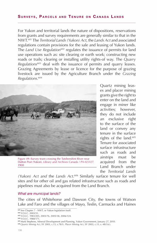
136
S u r v e y S , P a r c e l S a n d T e n u r e o n c a n a d a l a n d S
ForYukonandterritoriallandsthenatureofdispositions,reservationsfromgrantsandsurveyrequirementsaregenerallysimilartothatintheNWT.601TheTerritorial Lands (Yukon) Act,theLands ActandassociatedregulationscontainprovisionsforthesaleandleasingofYukonlands.TheLand Use Regulation602regulatestheissuanceofpermitsforlanduseoperationssuchas:siteclearingorearthwork;constructingnewroadsor trails;clearingor installingutility rights-ofway.TheQuarry Regulations603 deal with the issuance of permits and quarry leases.GrazingAgreements by lease or licence for the purpose of grazinglivestock are issued by the Agriculture Branch under the Grazing Regulations.604
Quartz mining leas-esandplacermininggrantsgivetherighttoenteronthelandandengage inminer likeactivities; however,they do not includean exclusive rightto the surfaceof theland or convey anytenure in thesurfacerights of the land.605Tenureforassociatedsurfaceinfrastructuresuch as roads andairstrips must beacquired from theLand Branch underthe Territorial Lands
(Yukon) Act and the Lands Act.606 Similarly surface tenure for wellsitesandforotheroilandgasrelatedinfrastructuresuchasroadsandpipelinesmustalsobeacquiredfromtheLandBranch.
What are municipal lands?
The cities of Whitehorse and Dawson City, the towns of WatsonLakeandFaroandthevillagesofMayo,Teslin,CarmacksandHaines601SeeChapter7-NWT,orYukonlegislationitself.602Y.O.I.C.2003/51.603Y.O.I.C.1983/205,2003/76,2005/38,2006/124.604Y.O.I.C.1988/171.605MarkStephens,MineralDevelopmentandPlanning,YukonGovernment,January27,2010.606Quartz Mining Act,SY2003,c.13,s.78(1).Placer Mining Act,SY2003,c.13,s.48(1)(c).
Figure49–SurveyteamcrossingtheTatshenshiniRivernearDaltonPost(Yukon).Library and Archives Canada / PA-023127.1900

137
Yukon 9
Junction all are municipal corporations607 and may use, hold anddisposeofland.Theyallhavecommunityplanningresponsibilities.ThecitiesofWhitehorseandDawsonhavesubdivisionapprovalauthorityaswell.608Municipallandsareheldbymunicipalitiesasprivatelands.
How are mineral rights managed?
Mining legislation inYukongoesas farbackas1897when thefirstregulations forplacerminingweremadeunder theDominion Lands Act.609 Until April 1, 2003, when the Yukon Act came into force,mininginYukonwasunderadministrationofthefederalgovernment.NowitisadministeredbytheMineralsResourcesBranch,DepartmentofEnergyMinesandResources,YukonGovernmentunderthePlacer Mining Act610 and theQuartz Mining Act.611 TheseActs mirror thepreviousfederalActs.612
Yukon is divided into four mining districts with mining recordersin Watson Lake, Whitehorse, Mayo and Dawson City. The miningrecordersgrantand recordmining interestsandprovide informationonthegroundopenforstaking.613TheYukonGovernmenthasmineralrightstoapproximately90%ofthelandareainYukon.614
Quartzminingreferstohardrockmining.AnindividualorcompanymayprospectandstakeamineralclaiminYukonunder theQuartz Mining Act.OnceaclaimhasbeenstakeditmustberecordedwiththeMiningRecorder.Afterworkhasbeencompletedontheclaimandacertificateofimprovementhasbeengranted,aleaseoftheclaimmaybeobtainedwhichentitlestheownertoallsubsurfacemineralsalongwiththerighttoenteronanduseandoccupythesurfaceforminerlikeoperation.615Termsofleasesarefortwenty-oneyearswithprovisionforrenewalforfurthertwenty-oneyearterms.616
TherecordedownerofamineralclaimisrequiredtohaveasurveyofitmadebyadulyqualifiedCLSundergeneralinstructionsfromtheSurveyorGeneralwithinoneyearfromthedateonwhichnotificationby the Minister to do so is sent to the owner.617 Specific survey607VillagesestablishedasmunicipalcorporationsbyY.O.I.C.’s;1984/145,1984/219,1984/272.1984/309.608SummaryofLandManagementAuthoritieswithinYukonMunicipalities,Edition1,October2007:
GovernmentofYukon.609Lambrecht,The Administration of Dominion Lands1870-1930,p.375610S.Y.2003,c.14.611S.Y.2003,c.13.612Yukon Act,S.Y.2002,c.7,s.45.YukonNorthernAffairsProgramDevolutionTransferAgreement.613YukonMiningRecorder,EnergyMinesandResources:YukonWebsite.AccessedOct.12,2010.614AreabasedontheareaofalllandinYukonlessthatcoveredbysettlementagreementstodate(approximately
5%)andNationalParks(approximately5%)ofthesubsurfacearea.615Quartz Mining Act,S.Y.2003,c.14,s.74,s.78(1).616Quartz Mining Act,S.Y.2003,c.14,s.103.617Quartz Mining Act,S.Y.2003,c.14,s.86(1).

138
S u r v e y S , P a r c e l S a n d T e n u r e o n c a n a d a l a n d S
instructionsarenotrequiredalthoughlotnumbersmustbeobtainedfromtheSurveyorGeneralsBranch(SGB)inWhitehorse.
Placerminingisthetechniqueofrecoveringgoldfromgravel.Anyoneover theageof18mayprospectandstakeaplacerclaim inYukonunderthePlacer Mining Act.618OnceaplacerclaimhasbeenstakeditisrecordedwiththeMiningRecorderandifitisapprovedtheminingrecordermay issue a grant.Grants of placer claims give the holdertheexclusiverighttoenterontheclaimforminer-likeworkandtotheproceedsrealizedfromit.619Thesegrantscanbeissuedforaperiodofonetofiveyearsdependingonthefeespaidinadvance.620
There are two types of surveysmade under thePlacer Mining Act:surveysofbase linesand surveysofplacerclaims.Abase lineof acreek or river is a surveyed line following the general direction ofthecentrebottomlandsofavalleyofacreekorriver,establishedtocontrolandreferencethelocationofplacerminingclaims.621Forbaselinesurveysspecificsurveyinstructionsarerequired.SurveysofplacerclaimsdonotrequirespecificsurveyinstructionsalthoughlotnumbersmustbeobtainedfromtheSGBinWhitehorse.
Themining recorder is also responsible for issuing leasesunder theDredging Regulation622 and exploration licences and permits andleases for coal mining under theCoal Regulation.623 TheDredging Regulation requiressurveystobecarriedoutundertheinstructionsoftheSurveyorGeneralwhendirectedbytheMinister.624Specificsurveyinstructionsare required.Therearenoprovisions for surveys in theCoal Regulation.
How are oil and gas rights managed?
RightstooilandgasareadministeredbytheOilandGasManagementBranch of the Department of Energy,Mines and Resources, YukonGovernment.CopiesofdocumentspertainingtooilandgasinrightsinYukonareavailablefromthisBranchinWhitehorse.
TheOil and Gas Act625cameintoforcein1998whentheadministrationofoilandgaswastransferredtoYukon.UndertheActtwotypesofdispositionsmaybegranted.Anoilandgaspermitgivestherightto
618S.Y.2003,c.13,s.17(1).619Placer Mining Act,S.Y.2003.c.13,s.48(1).620Placer Mining Act,S.Y.2003.c.13,s.41(1).621Placer Mining Act,S.Y.2003,c.13,ss.Part1,Definitions,2(1),40.622Y.O.I.C.2003/55623Y.O.I.C.2003/54.624Y.O.I.C.2003/55,s.7.625R.S.Y.c.162.
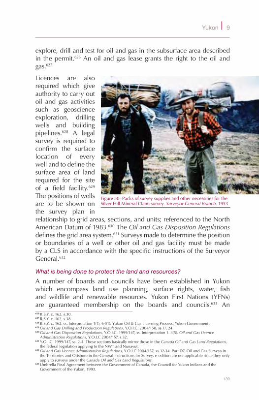
139
Yukon 9
explore,drillandtestforoilandgasinthesubsurfaceareadescribedin thepermit.626Anoilandgas leasegrants the right to theoilandgas.627
Licences are alsorequired which giveauthoritytocarryoutoil and gas activitiessuch as geoscienceexploration, drillingwells and buildingpipelines.628 A legalsurvey is required toconfirm the surfacelocation of everywellandtodefinethesurface area of landrequired for the siteof a field facility.629Thepositionsofwellsare to be shown onthe survey plan inrelationshiptogridareas,sections,andunits;referencedtotheNorthAmericanDatumof1983.630TheOil and Gas Disposition Regulationsdefinesthegridareasystem.631Surveysmadetodeterminethepositionor boundaries of awell or other oil and gas facilitymust bemadebyaCLSinaccordancewiththespecificinstructionsoftheSurveyorGeneral.632
What is being done to protect the land and resources?
A number of boards and councils have been established in Yukonwhich encompass land use planning, surface rights, water, fishand wildlife and renewable resources. Yukon First Nations (YFNs)are guaranteed membership on the boards and councils.633 An626R.S.Y.c.162,s.30.627R.S.Y.c.162,s.38628R.S.Y.c.162,ss.Interpretation1(1),64(1).YukonOil&GasLicensingProcess,YukonGovernment.629Oil and Gas Drilling and Production Regulations,Y.O.I.C.2004/158,ss.17,24.630Oil and Gas Disposition Regulations,Y.O.I.C.1999/147,ss.Interpretation1.4(5).Oil and Gas Licence
Administration Regulations,Y.O.I.C2004/157,s.32.631Y.O.I.C.1999/147,ss.2-4.ThesesectionsbasicallymirrorthoseintheCanada Oil and Gas Land Regulations,
thefederallegislationapplyingtotheNWTandNunavut.632Oil and Gas Licence Administration Regulations,Y.O.I.C2004/157,ss.32-34.PartD7,OilandGasSurveysin
theTerritoriesandOffshoreintheGeneralInstructionsforSurvey,e-editionarenotapplicablesincetheyonlyapplytosurveysundertheCanada Oil and Gas Land Regulations.
633UmbrellaFinalAgreementbetweentheGovernmentofCanada,theCouncilforYukonIndiansandtheGovernmentoftheYukon,1993.
Figure50–PacksofsurveysuppliesandothernecessitiesfortheSilverHillMineralClaimsurvey.Surveyor General Branch.1953
140
S u r v e y S , P a r c e l S a n d T e n u r e o n c a n a d a l a n d S
environmentalassessmentprocessapplyingtoalllandsinYukonwasachievedin2003withthepassageofthefederalYukonEnvironmentaland Socio-economic Act.634 The Yukon Environmental and Socio-EconomicAssessmentBoardestablishedundertheActisresponsiblefordelivering theassessmentprocess.Of thesevenmembersof theBoardthreearenominatedbytheCouncilofYFNs.635
Are there treaties and Indian reserves?
AsearchoftheCanadaLandsSurveyRecordsshowssurveyrecordsforlessthan10ReservesinYukon.Severalofthese,forexample:CarcrossNo.4,LakeLabergeNo.1,McQuestenNo.3,andMoosehideCreekNo.2 were established before 1905. Although Treaty 11, signed in1921, included the southeast corner of Yukon - no Reserves wereestablished.AllReservelandsintheYukonarenowsettlementlandsandtheIndian Actnolongerappliestosuchlands.636
How did land claims evolve?
In 1973 Elijah Smith, the first chairman of the Council for YukonIndians,andadelegationofYFNchiefstraveledtoOttawatopresent“TogetherTodayforourChildrenTomorrow”astatementofgrievancesandprinciplesfornegotiatingalandclaim.ThiswasnotthefirsttimeconcernsaboutYFNtraditionalareashadbeenexpressed,butitwasthe start of the negotiation process. Negotiations culminated in the1993Umbrella FinalAgreement (UFA) between theGovernment ofCanada, the Yukon Government and YFNs as represented by theCouncilofYFNs.TheUFAisacommontemplateunderwhicheachYFNnegotiatesitsfinalagreement.Itincludesprovisionsdealingwithland, financial compensation, land use and planning andwith YFNinvolvementingovernmentinstitutions,harvesting,forestryandwaterconservation.637
What are First Nation final agreements?
TheYukon First Nations Land Claims Settlement Actcameintoforcein 1995. It acknowledged that the provisions in theUFA are to beincorporatedintothefinalagreementswitheachYFN.638TheActalsoapprovedandgaveeffecttofourfinalagreements:639634S.C.2003,c.7.635YukonEnvironmentalandSocio-economicAssessmentBoardAnnualReport,08/09.636SeetheYukon First Nations Land Claims Settlement Act,S.C.1994,c.34,s.12,theindividualFirstNation
FinalAgreements,s.4.1.0.,andtheYukon First Nations Self-Government Act,1994,c.35,s.5(1)(2)andtheindividualFirstNationSelf-GovernmentAgreements,s.29.
637HistoryofLandClaims,CouncilofYukonFirstNations.What’sInaFinalAgreement?YukonGovernment.638UFA,preamble.AlsoseeCarcross/Tagish First Nation v. Canada(C.A.),2001FCA231.639S.C.1994,c.34.AlsoapprovedbytheYukonGovernment:An Act Approving Yukon Land Claim Final
AgreementsS.Y.1993,c.19.

141
Yukon 9
◆ ChampagneandAishihikFirstNation;◆ FirstNationofNachoNyakDun;◆ TeslinTlingitCouncil;and◆ VuntutGwitchinFirstNation.
Subsequently,sevenfinalagreementswereapproved:
◆ LittleSalmon/CarmacksFirstNation(1997);◆ SelkirkFirstNation(1997);◆ Tr’ondëkHwëch’in(1998);◆ Ta’anKwäch’änCouncil(2002);◆ KluaneFirstNation(2004);◆ KwanlinDünFirstNation(2005);and◆ Carcross/TagishFirstNation(2006).
Three FirstNations have not settled land claims: Liard FirstNation,RossRiverDenaCouncilandWhiteRiverFirstNation.640
What are transboundary agreements?
Some Aboriginal uses of land have traditionally crossed territorialboundaries;otherareashavebeensharedamongAboriginalgroups.641TransboundaryagreementsdealwiththerightsofAboriginalPeoplesin matters such as harvesting, land access, land use planningand development. The Gwich’in and the Inuvialuit of NWT havetransboundary agreements for lands and traditional use rights inYukon.OtherAboriginalGroups thatwill likelyhave transboundaryagreementsforlandinYukonaretheDene/MetisintheNWTandtheKaskaDenaCouncil, TahltanTribalCouncil andTakuRiver TlingitsFirstNationsinBritishColumbia.642
What are settlement lands?
Each FirstNation’s final agreement identifies the settlement land tobereceived.UndertheUFAthe14YFNswillreceive41,595km2ofsettlementlandtobedividedamongstthem.Thisisapproximately9%ofthetotallandareaofYukon.Thefollowingtypesoflandbecomesettlement lands on the effective date of each YFN’s settlementagreement:643
◆ CategoryA(25,900km2ofsurfaceandsub-surfaceland),◆ CategoryB(15,540km2ofsurfacelandonly),
640YukonToday,GovernmentofYukonWebsite.AccessedOct.12,2010.641UFA,c.1,definitions,p.7andc.25.642RolesandResponsibilitiesofGovernments,YukonEnergyMinesandResources.YukonNorthernAffairs
ProgramDevolutionTransferAgreement,definitions643UFA,c.1,definitions,c.5.3.1.,7.5.2.8.
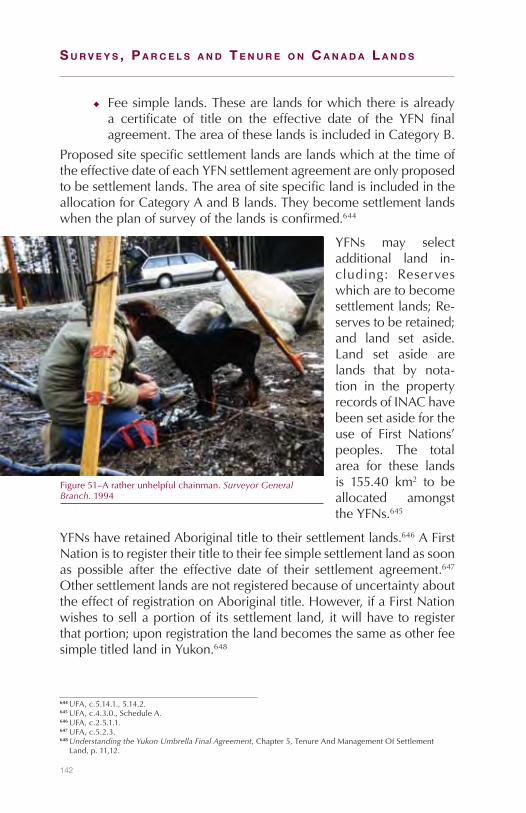
142
S u r v e y S , P a r c e l S a n d T e n u r e o n c a n a d a l a n d S
◆ Feesimplelands.Thesearelandsforwhichthereisalreadya certificate of title on the effective date of the YFN finalagreement.TheareaoftheselandsisincludedinCategoryB.
ProposedsitespecificsettlementlandsarelandswhichatthetimeoftheeffectivedateofeachYFNsettlementagreementareonlyproposedtobesettlementlands.TheareaofsitespecificlandisincludedintheallocationforCategoryAandBlands.Theybecomesettlementlandswhentheplanofsurveyofthelandsisconfirmed.644
YFNs may selectadditional land in-cluding: Reserveswhicharetobecomesettlementlands;Re-servestoberetained;and land set aside.Land set aside arelands that by nota-tion in the propertyrecordsofINAChavebeensetasidefortheuse of First Nations’peoples. The totalarea for these landsis 155.40 km2 to beallocated amongsttheYFNs.645
YFNshaveretainedAboriginaltitletotheirsettlementlands.646AFirstNationistoregistertheirtitletotheirfeesimplesettlementlandassoonas possible after the effective date of their settlement agreement.647OthersettlementlandsarenotregisteredbecauseofuncertaintyabouttheeffectofregistrationonAboriginaltitle.However,ifaFirstNationwishestosellaportionofitssettlementland,itwillhavetoregisterthatportion;uponregistrationthelandbecomesthesameasotherfeesimpletitledlandinYukon.648
644UFA,c.5.14.1.,5.14.2.645UFA,c.4.3.0.,ScheduleA.646UFA,c.2.5.1.1.647UFA,c.5.2.3.648Understanding the Yukon Umbrella Final Agreement,Chapter5,TenureAndManagementOfSettlement
Land,p.11,12.
Figure51–Aratherunhelpfulchainman.Surveyor General Branch.1994
143
Yukon 9
What are special management areas?
SpecialmanagementareasareareasidentifiedandestablishedwithinaYFN’straditionalterritoryandincludeareassuchasnationalwildlifeareas, national parks, territorial parks, bird sanctuaries and heritagesites.TheobjectiveofdealingwithspecialmanagementareasintheUFA is tomaintain important features ofYukon’s natural or culturalenvironment while respecting the rights of Aboriginal peoples andYFNs.TheymaybeestablishedinaccordancewiththeUFApursuanttoanYFN’sfinalagreementorpursuanttolawsofgeneralapplication,suchastheNational Parks Act.
How are settlement lands managed?
TheYukon First Nations Self-Government ActandYFNselfgovernmentagreements provide for YFNs to enact laws for management andadministrationoftheirsettlementlandsandforallocationordispositionof rights and interests.649 Under the UFA, each YFN as owner ofsettlementland,may:
◆ enactbylawsfortheuseofandoccupationofitssettlementland;
◆ developandadministerlandmanagementprogramsrelatedtoitssettlementland;
◆ charge rent or other fees for the use and occupation of itssettlementland;and
◆ establishasystemtorecordinterestsinitssettlementland.650IneachYFN’sfinalagreement,eachYFNisrequiredtoestablishandthereaftermaintainapublicregisteridentifyingallrights,obligationsandliabilitiesheldonitsbehalf.651
SettlementlandsareCanadaLandsthereforeYFNsintheirlawsmayincludearequirementforsurveystobecarriedoutunderprovisionsintheCanada Lands Surveys Act.Sucharequirementprovidesqualityassurance forboundarydefinition to thoseobtaining landrightsandinterests. To date, several YFNs have opted to have surveys carriedunder the instructions of the Surveyor General and to have themrecordedintheCanadaLandsSurveyRecords.652
For sub-surface development by a non First Nation entity where aYFNhastitletothesurfacelands,thesurfacerightsmustbeacquired
649Yukon First Nations Self-Government Act, 1994, c.35ScheduleIII,PartIII,YFNselfgovernmentagreements,s.13
650UFA,c.5.5.0.651FirstNationfinalagreements,c.2.11.7.2.652BrianThompson,HeadCadastralServices,Yukon,SGB.January13,2010.

144
S u r v e y S , P a r c e l S a n d T e n u r e o n c a n a d a l a n d S
fromtheYFN.Inthecaseofdisputesregardingaccess,anorderoftheYukon Surface Rights Boardmade under the federalYukon Surface Rights Board Act653canauthorizeentryanduseofthesurfaceofthelandanddeterminecompensationforsurfacelandrightholders.
What are the requirements for the survey of settlement land boundaries?
Parcelsofsettlementland,ontheeffectivedateoftheindividualYFNsettlementagreement,aredefinedbymapsandwrittendescriptions.UnderthetermsoftheUFA,theboundariesofsettlementlandshallbesurveyedinaccordancewiththeinstructionsoftheSurveyorGeneralanddealtwithbyanofficialplan.654Whenplansofsurveyofsettlementlandsareconfirmedtheyreplacethepriormapsanddescriptions.655
Settlementlandcommitteesareestablishedunderthefinalagreements.UnderthetermseachYFNidentifiesandselectssitespecificsettlementlandoutofproposedsitespecificland,surveyprioritiesaredeterminedandportionsofboundariesofspecialmanagementareaswhichshouldbeconsidered fordefinitionby surveyare identified.656 Site specificlandsbecomesettlementlandswhentheplansofsurveyofthelandsareconfirmed.657
Althoughisolatedboundarystandardshavebeenusedforthesurveyofsettlementlands,allboundarysurveysmustnowbemonumentedevery1km.Asof2009,approximately90%oftheboundariesofsettlementlandsforapprovedfinalagreementshadbeensurveyed.Thisincludes1,986parcelswith16,820kmofboundary.Theboundariesofspecialmanagementareasmaybedefinedbyadministrativeorexplanatoryplans.658Asof2009,30,750kmofsuchboundariesweresurveyed.659
What is the system for registering private interests in land?
Private lands in Yukon are registered in the Land Titles Office inWhitehorse and administered under the Land Titles (Yukon) Act660by the Yukon Department of Justice. The Land Titles (Yukon) Act originated from earlier federal land titles legislation applying to alltheterritories.Asaresult,thesurveyprovisionswhenbringinglandsundertheActandwhendealingwithtransfersandothertransactionsaresimilartolandtitleslegislationintheNWT.OtherActsapplying
653S.C.1994,c.43.654UFA,c.15.2.1.655UFA,c.5.3.4656UFA,c.15.3.0.657UFA,c.5.14.1.,5.14.2.658UFA,c.15.2.2.659BobGray.DeputySurveyorGeneral,Yukon.TeleconDecember14,2009660R.S.Y.2002,c.130.
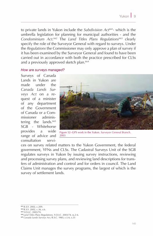
145
Yukon 9
toprivatelandsinYukonincludetheSubdivision Act661-whichistheumbrella legislation for planning formunicipal authorities - and theCondominium Act.662 The Land Titles Plans Regulations663 clearlyspecifytheroleoftheSurveyorGeneralwithregardtosurveys.UndertheRegulationstheCommissionermayonlyapproveaplanofsurveyifithasbeenexaminedbytheSurveyorGeneralandfoundtohavebeencarriedoutinaccordancewithboththepracticeprescribedforCLSsandapreviouslyapprovedsketchplan.664
How are surveys managed?
Surveys of CanadaLands in Yukon aremade under theCanada Lands Sur-veys Act on a re-quest of a ministerof any departmentof the GovernmentofCanadaoraCom-missioner adminis-tering the lands.665
SGB - Whitehorseprovides a widerange of advice andconsultation servi-cesonsurveyrelatedmatters to theYukonGovernment, the federalgovernment,YFNsandCLSs.TheCadastralSurveysUnitoftheSGBregulates surveys in Yukon by issuing survey instructions, reviewingandprocessingsurveyplans,andreviewinglanddescriptionsfortrans-fersofadministrationandcontrolandforordersincouncil.TheLandClaimsUnitmanagesthesurveyprograms,thelargestofwhichisthesurveyofsettlementlands.
661R.S.Y.2002,c.209.662R.S.Y.2002,c.36,s.6.663Y.O.I.C.2003/74.664Land Titles Plans Regulations,Y.O.I.C.2003/74,ss.2-6.665Canada Lands Surveys Act,R.S.C.1985,c.L-6,s.25
Figure52–GPSworkintheYukon.Surveyor General Branch.2003
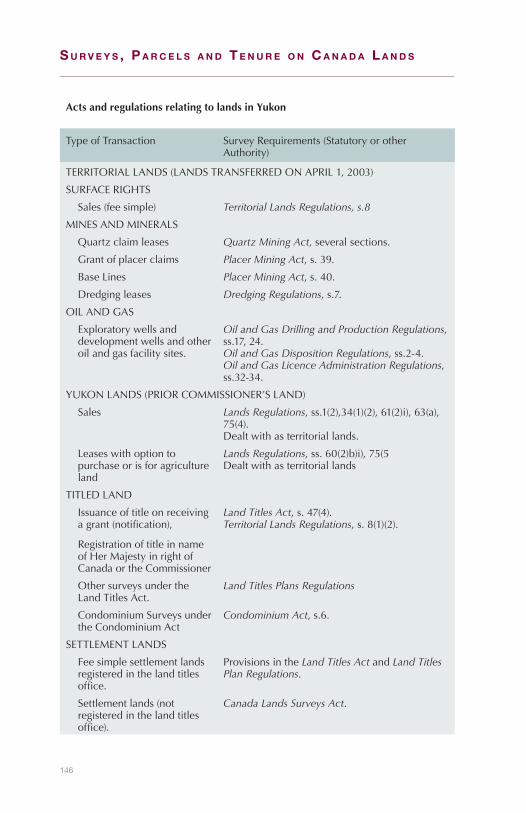
146
S u r v e y S , P a r c e l S a n d T e n u r e o n c a n a d a l a n d S
ActsandregulationsrelatingtolandsinYukon
TypeofTransaction SurveyRequirements(StatutoryorotherAuthority)
TERRITORIALLANDS(LANDSTRANSFERREDONAPRIL1,2003)
SURFACERIGHTS
Sales(feesimple) Territorial Lands Regulations, s.8
MINESANDMINERALS
Quartzclaimleases Quartz Mining Act,severalsections.
Grantofplacerclaims Placer Mining Act,s.39.
BaseLines Placer Mining Act,s.40.
Dredgingleases Dredging Regulations,s.7.
OILANDGAS
Exploratorywellsanddevelopmentwellsandotheroilandgasfacilitysites.
Oil and Gas Drilling and Production Regulations,ss.17,24.Oil and Gas Disposition Regulations,ss.2-4.Oil and Gas Licence Administration Regulations,ss.32-34.
YUKONLANDS(PRIORCOMMISSIONER’SLAND)
Sales Lands Regulations,ss.1(2),34(1)(2),61(2)i),63(a),75(4).Dealtwithasterritoriallands.
Leaseswithoptiontopurchaseorisforagricultureland
Lands Regulations,ss.60(2)b)i),75(5Dealtwithasterritoriallands
TITLEDLAND
Issuanceoftitleonreceivingagrant(notification),
RegistrationoftitleinnameofHerMajestyinrightofCanadaortheCommissioner
Land Titles Act,s.47(4).Territorial Lands Regulations,s.8(1)(2).
OthersurveysundertheLandTitlesAct.
Land Titles Plans Regulations
CondominiumSurveysundertheCondominiumAct
Condominium Act,s.6.
SETTLEMENTLANDS
Feesimplesettlementlandsregisteredinthelandtitlesoffice.
ProvisionsintheLand Titles Act andLand Titles Plan Regulations.
Settlementlands(notregisteredinthelandtitlesoffice).
Canada Lands Surveys Act.
147
10Offshore
What about rights in the offshore?
The definition of property in the offshore has been a matter ofcontention since the oceans were capable of being exploited. Thischapter explores the origins of boundary definitions in Canada’soffshore, through its evolution in early claims bymaritime powers,throughhistoricalandUnitedNationstreaties,toitspresentstate.
What is the offshore?
Whenwespeakoftheoffshore,imagesaboundof:secretivefinancialinstitutions,wiretransfers,andJamesBondmovies.Forthepurposesofthischapter,however,thetermhasawholeothermeaning.Itinvolvesfarmorewater, and far fewer laser beams. The accepted definitionoftheoffshoreis:“thesubmergedlandsandthesubsoilbelowit,thewatercolumnandtheairaboveit,seawardfromthelowwaterlineoftheState’smainlandandislands.”666
Canada Lands in the offshore comprise some 6.4 million squarekilometers667andaredefinedas:“anylandsunderwaterbelongingtoHerMajestyinrightofCanada…whichtheGovernmentofCanadahaspowertodispose.”668
666Calderbanketal.Canada’s Offshore: jurisdiction, rights, and management. 3rded. ACLS-CHA.2006667Calculatedfrom“Offshore”and“ExclusiveEconomicZone”polygonsin:AtlasofCanada.National
Frameworks Data, Administrative Areas.v.6.0668Canada Lands Surveys Act .R.S.C.1985.c.L-6,sec24(1)(b)

148
S u r v e y S , P a r c e l S a n d T e n u r e o n c a n a d a l a n d S
What is the international law of the sea?
Theinternationallawoftheseaisacompilationofvarioussovereignnations’ agreements, customary practices, general principles, andjudicialdecisions.669Thelawoftheseahasalonghistory.Muchofitdatesbacktoearlymerchants,astradebetweennationshashistoricallybeen of pivotal importance.670 One of the first examples of publicinternational law in the oceans came about in 1023: themonks ofCanterburyweregrantedsalvagerightsinfrontoftheportofSandwichintheCharter of King Cnut.671
TwooftheearlyEuropeanmaritimepowers,SpainandPortugal,dividedthe oceans amongst themselves in a series of Treaties. The Treaty of Tordesillas in 1494, for instance, created a boundary at 45°westlongitude,withthePortuguesecontrollingeverythingtotheeastoftheline,andtheSpanishcontrollingeverythingtothewest.672Thirtyyearslater,owing to largescaleexpeditions into thePacificOcean,SpainandPortugalratifiedtheTreaty of Saragossa toresolvedisputesoverinfluenceinAsia.Thiscreatedasecondmeridianatabout142°westlongitude,withthePortuguesecontrollingeverythingtothewestoftheline,andSpaincontrollingalltotheeast.673
Such vast expanses of ocean ownership, however, were clearlyuntenable,evenformaritimepowerslikePortugalandSpain.WhenSirFrancisDrakecircumnavigatedtheglobe(1577–1580)fortheEnglish,674itillustratedpoignantlytheinabilityofthePortugueseandSpanishtocontrolall the seas.Coupledwith strongcoloniesbeingestablishedbymaritimepowerslikeFranceandtheNetherlands,itwasclearthatdelimitationasdefinedintheTreaty of TordesillasandSaragossawaslittleaccepted.
Anothercornerstoneoftheinternationallawofthesea,theterritorialsea, appears to have been contemplated as early as the fourteenthcentury.675Theterritorialseawasdefinedbythedoctrineofeffectivecontrol,inthatastatecanclaimsovereigntyoveranareainwhichitcandemonstratecontrol.Todefinetheterritorialsea,thisdoctrinewasmademanifesttypicallyinthreeways:1)howfaracannoncouldshootfromshore,2)lineofsight,or3)somefixeddistance.Threenautical
669Statute of the International Court of Justice. Article38670Anand.Origins and Development of the Law of the Sea. TheHague.1982671Tanja.The legal determination of International Maritime Boundaries. Deventer.1990672Swarztrauber.The three mile limit of territorial seas. Annapolis.1972673Elton.The new Cambridge modern history.Vol.2(1520-1559).CambridgeUniversityPress.1990674SeeBawlf.The secret voyage of Sir Francis Drake. DouglasandMcIntyre.2003675Tanja.1990.pg1–20
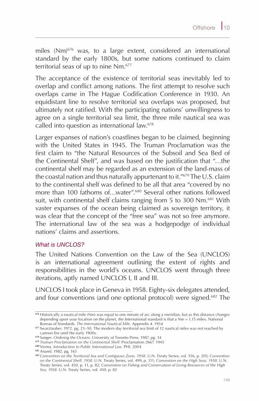
149
Offshore 10
miles (Nm)676 was, to a large extent, considered an internationalstandard by the early 1800s, but some nations continued to claimterritorialseasofuptonineNm.677
The acceptance of the existence of territorial seas inevitably led tooverlapandconflictamongnations.Thefirstattempttoresolvesuchoverlaps came in The Hague Codification Conference in 1930. Anequidistant line to resolve territorial seaoverlapswasproposed,butultimatelynotratified.Withtheparticipatingnations’unwillingnesstoagreeonasingleterritorialsealimit,thethreemilenauticalseawascalledintoquestionasinternationallaw.678
Largerexpansesofnation’scoastlinesbegantobeclaimed,beginningwith the United States in 1945. The Truman Proclamation was thefirst claim to “theNaturalResources of the Subsoil and SeaBedoftheContinentalShelf”,andwasbasedonthejustificationthat“…thecontinentalshelfmayberegardedasanextensionoftheland-massofthecoastalnationandthusnaturallyappurtenanttoit.”679TheU.S.claimtothecontinentalshelfwasdefinedtobeallthatarea“coveredbynomorethan100fathomsof…water”.680Severalothernationsfollowedsuit,withcontinentalshelfclaimsrangingfrom5to300Nm.681Withvasterexpansesof theoceanbeingclaimedassovereign territory, itwasclearthattheconceptofthe“freesea”wasnotsofreeanymore.The international law of the sea was a hodgepodge of individualnations’claimsandassertions.
What is UNCLOS?
The United Nations Convention on the Law of the Sea (UNCLOS)is an international agreement outlining the extent of rights andresponsibilities in theworld’s oceans.UNCLOSwent through threeiterations,aptlynamedUNCLOSI,IIandIII.
UNCLOSItookplaceinGenevain1958.Eighty-sixdelegatesattended,andfourconventions(andoneoptionalprotocol)weresigned.682The
676Historicallyanauticalmile(Nm)wasequaltooneminuteofarcalongameridian,butasthisdistancechangesdependinguponyourlocationontheplanet,theInternationalstandardisthataNm=1.15miles.NationalBureauofStandards.The International Nautical Mile. Appendix4.1954
677Swarztauber.1972.pg.23–50.Themoderndayterritorialsealimitof12nauticalmileswasnotreachedbycannonfireuntiltheearly1900s.
678Sanger.Ordering the Oceans. UniversityofTorontoPress.1987.pg.14679Truman Proclamation on the Continental Shelf. Proclamation2667.1945680Verma.Introduction to Public International Law. PHI.2004681Anand.1982.pg.165682Convention on the Territorial Sea and Contiguous Zone, 1958. U.N.TreatySeries,vol.516,p.205;Convention
on the Continental Shelf, 1958. U.N.TreatySeries,vol.499,p.311;Convention on the High Seas, 1958. U.N.TreatySeries,vol.450,p.11,p.82;Convention on Fishing and Conservation of Living Resources of the High Sea, 1958. U.N.TreatySeries,vol.450,p.82
150
S u r v e y S , P a r c e l S a n d T e n u r e o n c a n a d a l a n d S
conventionwaslargelydeemedtobeanenormoussuccessinthatthesignedconventionsincludedagreementsonthecontinentalshelf,theterritorialsea,conservationoflivingresources,andthehighseas.Twonotable omissionswere problematic, however: the actual extent (innumbers)oftheterritorialsea,andhowfarfishingrightsextendedpasttheterritorialsea.
As the inkwasstilldryingon theUNCLOSIconventions, the“CodWar” between Iceland and Britain was in full swing. Iceland hadclaimedaterritorialsea(andexclusivefishingrights)of12Nm.Britainrefused to recognize the international legitimacyof sucha limitandcontinued fishing within 4Nm of Iceland. Several confrontationsfollowed.OnSeptember4,1958,anIcelandicpatrolboatattemptedtoseizeaBritishfishingvesselinsidethe12Nmlimit,butwaspreventedfromdoing sobyaBritishnavy frigate.Amonth later, an IcelandicpatrolshipfiredthreeshotsacrossanotherBritishfishingvessel,forcingaBritishretreat.Amonthafterthat,shotswereagainfiredataBritishfishing vessel within the 12Nm Icelandic claim. The British navyarrivedandthreatenedtosinktheIcelandicpatrolship,andtheBritishfishingvesselescaped.
Ultimately Britain and Iceland conceded that any future disputes inregards tofishingzoneswouldbe sent to the InternationalCourtofJustice(ICJ)683forresolution.The“codwar”,however,highlightedtheimportance of a specific territorial sea limit.684 The United NationspassedaresolutioninDecemberof1958forasecondconventiononthelawofthesea(UNCLOSII)totackletheunresolvedissues.
Meetingagain inGeneva,UNCLOS II tookplace in1960,with thegoalofaddressingtheterritorialsealimit.AjointCanada/U.S.proposalfor a sixmile territorial sea and a further sixmile exclusive fisheryzonewasdefeatedbyonevote.UNCLOSII,therefore,wasconsidereda failureas itproducednotangibleresults.FollowingUNCLOSII, itbecameincreasinglyclearthatcompetingandconflictinginterestsintheoceanswouldneverceaseuntil thefailuresofUNCLOSIIcouldbeaddressed.685
In1967,ArvidPardo(thenaUNambassadorforMalta)proposedtotheUNthattheoceanandtheoceanfloorbeyondnationaljurisdictionbepart of the “commonheritageofmankind”, and that anywealth683TheInternationalCourtofJustice(ICJ)isthe“principaljudicialorganoftheUnitedNations”.Statute of the
International Court of Justice. Article1684Johannesson.How‘codwar’came:theoriginsoftheAnglo-Icelandicfisheriesdispute,1958-61.Historical
Research. Vol.77,pp.543–574.2004685Anand.1982.pg185–189

151
Offshore 10
accruedinthatareashouldbeusedtohelpbridgethegapbetweenwealthierandpoorernations.686Pardo’sspeechledtotheestablishmentofaUNad-hoccommittee to studyhis suggestions,andeventuallytotheacceptanceofthe“commonheritageofmankind”asacrucialcomponentofthelawofthesea.687
ThesamecommitteetaskedwithexaminingPardo’ssuggestionswasalso tasked with preparing for the third Conference on the Law ofthe Sea (UNCLOS III). The preparations themselves took five years(1967-72),andtheconferenceitself tooknineyears(1973-82)beforeitwas concluded.On its completion,UNCLOS IIIwas regarded as“possiblythemostsignificantlegalinstrumentofthecentury”.688Theconvention itselfwasa “packagedeal” tobeacceptedas is,ornotat all. The breadth of the convention was impressive, dealing with(amongothers):
◆ navigationalrights,◆ territorialsealimits,◆ economicjurisdiction,◆ legalstatusof resourcesontheseabedbeyondthe limitsofnationaljurisdiction,
◆ passageofshipsthroughnarrowstraits,◆ conservationandmanagementoflivingmarineresources,◆ protectionofthemarineenvironment,◆ amarineresearchregimeand,◆ abindingprocedureforsettlementofdisputesbetweenStates
When a government signs the convention it agrees not to take anyactionwhichmightbeinconflictwiththepurposesoftheconference.While being a signatory to the conference is relevant, the morepertinentactionisthatofratification(oraccession).Onceagovernmentratifiestheconferenceitagreestobeboundbyallitsterms.UNCLOSIIIrequired60ratificationsbeforeitbecameeffective,anditcameintoforceinNovember1994.Some159countrieshaveratifiedUNCLOSIII.CanadabecameasignatorytoUNCLOSinDecember1982,andratifieditinNovemberof2004.689
686Theactualuseof“commonheritageofmankind”wasadoptedinUNCLOSIII.United Nations Convention on the Law of the Sea. Article138.U.N.Treatyseries397.1982
687Declaration of Principles Governing the Seabed and Ocean Floor. U.N.G.A.Res.2749.Dec.12,1970688U.N.DivisionforOceanAffairs.The United Nations Convention on the Law of the Sea (a historical
perspective). 1998689U.N.DivisionforOceanAffairs.Chronological list of ratifications, accessions and successions to the
Convention and the related Agreements. 2009
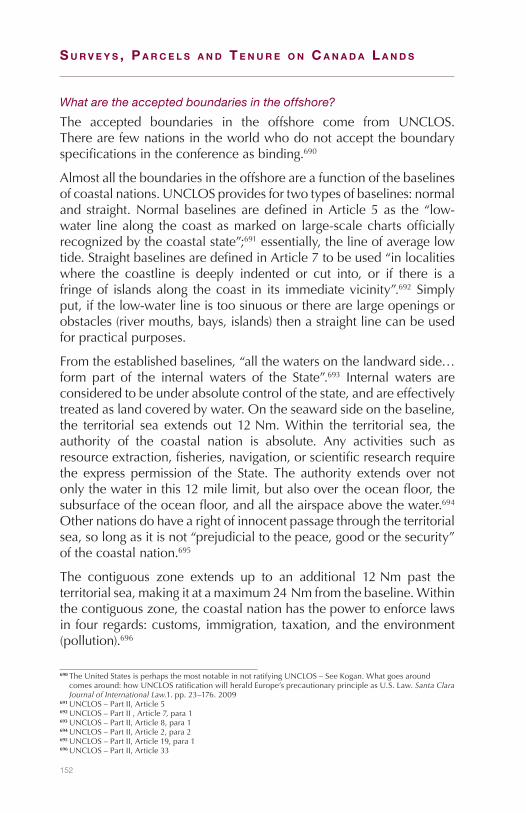
152
S u r v e y S , P a r c e l S a n d T e n u r e o n c a n a d a l a n d S
What are the accepted boundaries in the offshore?
The accepted boundaries in the offshore come from UNCLOS.Therearefewnationsintheworldwhodonotaccepttheboundaryspecificationsintheconferenceasbinding.690
Almostalltheboundariesintheoffshoreareafunctionofthebaselinesofcoastalnations.UNCLOSprovidesfortwotypesofbaselines:normaland straight.Normalbaselinesaredefined inArticle5as the “low-water linealong thecoastasmarkedon large-scalechartsofficiallyrecognizedbythecoastalstate”;691essentially,thelineofaveragelowtide.StraightbaselinesaredefinedinArticle7tobeused“inlocalitieswhere the coastline is deeply indented or cut into, or if there is afringeof islandsalong thecoast in its immediatevicinity”.692Simplyput,ifthelow-waterlineistoosinuousortherearelargeopeningsorobstacles(rivermouths,bays,islands)thenastraightlinecanbeusedforpracticalpurposes.
Fromtheestablishedbaselines,“allthewatersonthelandwardside…form part of the internalwaters of the State”.693 Internalwaters areconsideredtobeunderabsolutecontrolofthestate,andareeffectivelytreatedaslandcoveredbywater.Ontheseawardsideonthebaseline,the territorial sea extends out 12Nm.Within the territorial sea, theauthority of the coastal nation is absolute. Any activities such asresourceextraction,fisheries,navigation,orscientificresearchrequirethe express permission of the State. The authority extends over notonlythewaterinthis12milelimit,butalsoovertheoceanfloor,thesubsurfaceoftheoceanfloor,andalltheairspaceabovethewater.694Othernationsdohavearightofinnocentpassagethroughtheterritorialsea,solongasitisnot“prejudicialtothepeace,goodorthesecurity”ofthecoastalnation.695
The contiguous zone extends up to an additional 12Nm past theterritorialsea,makingitatamaximum24Nmfromthebaseline.Withinthecontiguouszone,thecoastalnationhasthepowertoenforcelawsinfourregards:customs,immigration,taxation,andtheenvironment(pollution).696
690TheUnitedStatesisperhapsthemostnotableinnotratifyingUNCLOS–SeeKogan.Whatgoesaroundcomesaround:howUNCLOSratificationwillheraldEurope’sprecautionaryprincipleasU.S.Law.Santa Clara Journal of International Law.1.pp. 23–176.2009
691UNCLOS–PartII,Article5692UNCLOS–PartII,Article7,para1693UNCLOS–PartII,Article8,para1694UNCLOS–PartII,Article2,para2695UNCLOS–PartII,Article19,para1696UNCLOS–PartII,Article33
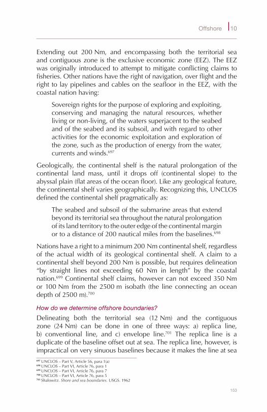
153
Offshore 10
Extending out 200Nm, and encompassing both the territorial seaandcontiguouszoneistheexclusiveeconomiczone(EEZ).TheEEZwasoriginallyintroducedtoattempttomitigateconflictingclaimstofisheries.Othernationshavetherightofnavigation,overflightandtherighttolaypipelinesandcablesontheseafloorintheEEZ,withthecoastalnationhaving:
Sovereignrightsforthepurposeofexploringandexploiting,conserving and managing the natural resources, whetherlivingornon-living,ofthewaterssuperjacenttotheseabedandoftheseabedanditssubsoil,andwithregardtootheractivitiesfortheeconomicexploitationandexplorationofthezone,suchastheproductionofenergyfromthewater,currentsandwinds.697
Geologically, thecontinental shelf is thenaturalprolongationof thecontinental land mass, until it drops off (continental slope) to theabyssalplain(flatareasoftheoceanfloor).Likeanygeologicalfeature,thecontinentalshelfvariesgeographically.Recognizingthis,UNCLOSdefinedthecontinentalshelfpragmaticallyas:
Theseabedandsubsoilofthesubmarineareasthatextendbeyonditsterritorialseathroughoutthenaturalprolongationofitslandterritorytotheouteredgeofthecontinentalmarginortoadistanceof200nauticalmilesfromthebaselines.698
Nationshavearighttoaminimum200Nmcontinentalshelf,regardlessof the actualwidth of its geological continental shelf. A claim to acontinentalshelfbeyond200Nmispossible,butrequiresdelineation“by straight lines not exceeding 60 Nm in length” by the coastalnation.699Continentalshelfclaims,howevercannotexceed350Nmor100Nm from the2500m isobath (the line connectinganoceandepthof2500m).700
How do we determine offshore boundaries?
Delineating both the territorial sea (12Nm) and the contiguouszone (24Nm) can be done in one of three ways: a) replica line,b) conventional line, and c) envelope line.701 The replica line is aduplicateofthebaselineoffsetoutatsea.Thereplicaline,however,isimpracticalonverysinuousbaselinesbecauseitmakesthelineatsea697UNCLOS–PartV,Article56,para1(a)698UNCLOS–PartVI,Article76,para1699UNCLOS–PartVI,Article76,para7700UNCLOS–PartVI,Article76,para5701Shalowitz.Shore and sea boundaries. USGS.1962
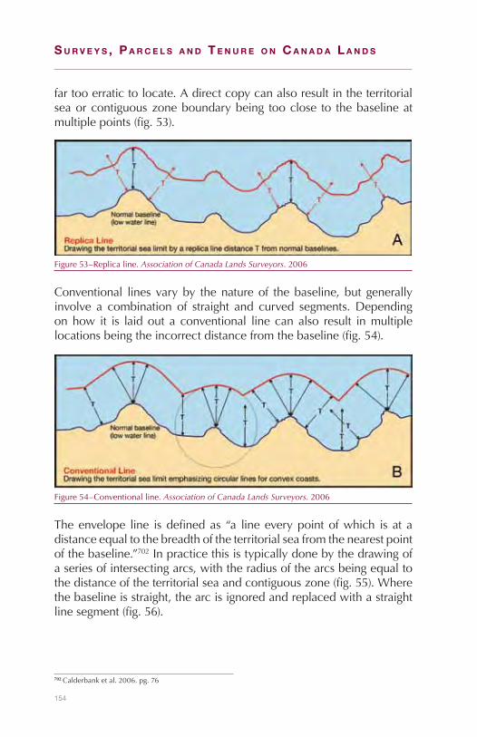
154
S u r v e y S , P a r c e l S a n d T e n u r e o n c a n a d a l a n d S
fartooerratictolocate.Adirectcopycanalsoresultintheterritorialseaorcontiguouszoneboundarybeing tooclose to thebaselineatmultiplepoints(fig.53).
Figure53–Replicaline.Association of Canada Lands Surveyors.2006
Conventional lines varyby thenatureof thebaseline,but generallyinvolve a combination of straight and curved segments.Dependingonhow it is laidout aconventional linecanalso result inmultiplelocationsbeingtheincorrectdistancefromthebaseline(fig.54).
Figure54–Conventionalline.Association of Canada Lands Surveyors.2006
Theenvelope line isdefinedas “a lineeverypointofwhich isat adistanceequaltothebreadthoftheterritorialseafromthenearestpointofthebaseline.”702Inpracticethisistypicallydonebythedrawingofaseriesofintersectingarcs,withtheradiusofthearcsbeingequaltothedistanceoftheterritorialseaandcontiguouszone(fig.55).Wherethebaselineisstraight,thearcisignoredandreplacedwithastraightlinesegment(fig.56).
702Calderbanketal.2006.pg.76
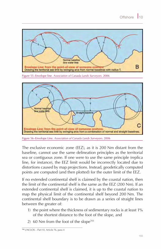
155
Offshore 10
Figure55–Envelopeline.Association of Canada Lands Surveyors.2006
Figure56–EnvelopeLine.Association of Canada Lands Surveyors.2006
Theexclusiveeconomiczone(EEZ),asitis200Nmdistantfromthebaseline,cannotusethesamedelineationprinciplesastheterritorialseaorcontiguouszone.Ifoneweretousethesameprinciple(replicaline, forinstance), theEEZlimitwouldbeincorrectlylocatedduetodistortionscausedbymapprojections.Instead,geodeticallycomputedpointsarecomputed(andthenplotted)fortheouterlimitoftheEEZ.
Ifnoextendedcontinentalshelfisclaimedbythecoastalnation,thenthelimitofthecontinentalshelfisthesameastheEEZ(200Nm).Ifanextendedcontinentalshelfisclaimed,itisuptothecoastalnationtomapthephysical limitof thecontinentalshelfbeyond200Nm.Thecontinentalshelfboundaryistobedrawnasaseriesofstraightlinesbetweenthegreaterof:
1) thepointwherethethicknessofsedimentaryrocksisatleast1%oftheshortestdistancetothefootoftheslope,and
2) 60Nmfromthefootoftheslope703
703UNCLOS–PartVI,Article76,para4
156
S u r v e y S , P a r c e l S a n d T e n u r e o n c a n a d a l a n d S
However,thelimitofthecontinentalshelfisalsoconstrainedto350Nmfromthebaselineor100Nmfromthe2500misobath,whicheverisgreater (see fig. 57).704 Determining the extended continental shelfisboth laboriousandexpensiveendeavor that requiresmappingof:a)thegradientrateofchangeneartheareaatthefootofthecontinentalslope,b)thicknessofthesedimentaryrocksat(andbeyond)thefootoftheslope,andc)locatingthe2500misobath.705Thesefeaturesmustbemappedatintervalsnotexceeding60Nmbetweenobservations,706andthenmustbereviewedandapprovedbytheCommission on the Limits of the Continental Shelf.707TheCommissionmeetstwiceayearattheUNheadquartersinNewYorktoconsidersubmissions.708
What are Canada’s offshore boundaries?
In principle, Canada’s offshore boundaries are those defined bythe parameters in UNCLOS (12Nm territorial sea, 200Nm EEZ,for instance) and set out in federal legislation in theOceans Act.709However, there are often many historical, political and economicfactors at play. IfCanada’s boundariesweredrawn strictly from theparameters in UNCLOS, we would share overlaps with the UnitedStates,Denmark,Russia,andFrance.Someoftheoverlapshavebeenresolvedbyagreementorinternationaladjudicationwhileothersarestillunresolved.
In1846,forinstance,the49thparallelboundarybetweentheUnitedStates and Canada was extended out to sea off the west coast.VancouverIsland,however,wasintheway,sotheboundaryhadtoberedirectedsouth.TheU.S.andGreatBritain (forCanada)agreedthat the boundary would run through “the middle channel whichseparatestheContinentfromVancouver’sIsland”.710Unfortunately,theboundarywasdrawnbasedonoutdatedmaps,withtheresultthatthelineactuallyranthroughaseriesofislands.OneofthesewasSanJuanIsle,andin1859apigbelongingtotheHudsonBayCompany(ontheCanadian sideof the island)began routingaround in apotato cropofanAmerican farmer (on theAmericanside).Thusbegan the“PigWar”.ThefarmershottheHBCpig,refusedtoreimbursefordamages,over400U.S.troopswerebroughtinto“protectAmericancitizens”,
704UNCLOS–PartVI,Article76,para5705Calderbanketal.2006.pg87706UNCLOS–PartVI,Article76,para7707UN.Scientific and Technical Guidelines of the Commission on the Limits of the Continental Shelf. para7.2.11.
1999708UN.Commission on the Limits of the Continental Shelf (CLCS) – Purpose, functions, and sessions. 2009709Oceans Act. 1996,c.31710Treaty Establishing the Boundary in the Territory on the Northwest Coast of America Lying Westward of the
Rocky Mountains. SignedatWashington,June15,1846

157
Offshore 10
and aBritishNaval attackwasonly calledoff at the last second.711Thestandofflasteduntil1872whenbothpartiesagreedtoacceptthearbitrationoftheEmperorofGermanyonthelocationoftheboundary,whosedecisioncoincidedwiththeAmericanclaimthroughthe“CanaldeHaro”.712
OtherlessdramaticadjudicationsincludetheGulf of Maine case,inwhichtheICJdecidedin1984thatfourlatitudeandlongitudepointsconnectedbythreegeodeticlinesweretheCanada-U.S.EEZboundaryintheGulfofMaineandGeorgesBankarea.713In1992,themaritimeboundarybetweenCanadaandFrancearoundtheFrenchislandsofSt.PierreandMiquelonwasdecidedbyarbitration.ThisleftanareaofFrenchcontrol inCanada’s territorialseaandEEZoffofCanada’seastcoast.714Canadahasalsoresolvedsomeofitsoffshoreboundariesthrough agreement. In 1973, for example, Denmark and Canadaagreedon the limitof thecontinental shelfbetweenGreenlandandtheCanadianArctictobeaseriesofgeodesiclinesbetweenlatitudesof61°Nand75°N.715
Areasofcontentionstilldoexist.Where theCanada/U.S.boundaryextends into the Beaufort Sea, for instance, has been a source ofcompetingclaimsmostlyduetopotentialresourcerevenues.Canadahas claimed the extension of the 141st meridian into the Beaufort,while the U.S. has claimed an equidistant line - the two locationsdiffersubstantially.716HansIsland,asmalluninhabitedrockbetweenGreenland and Canada in Kennedy Channel is claimed by bothCanadaandDenmark.Thecontinental shelfboundaryagreed tobybothcountries in1973stopswithina fewhundredmetresoneitherside of the Island.717Claims to an extended continental shelf in theAtlanticwillmost likely requirenegotiation to resolveoverlapswithbothDenmark(in theLabradorSea),andwiththeUnitedStates(onGeorgesBank).ResolutionofoverlappingclaimstoanextendedshelfintheArcticwillmostlikelyrequireagreementswiththeUnitedStates,Denmark,andRussia.718
711Ferguson.Canadian History for Dummies. Wiley.2005712Protocol of a Conference at Washington, March 10, 1873, Respecting the Northwest Water-Boundary713ICJ. Case concerning delimitation of the maritime boundary in the Gulf of Maine Area.JudgmentofOctober
12,1984.714delaFayette.TheAwardintheCanada-FranceMaritimeBoundaryArbitration. The International Journal of
Marine and Coastal Law,v8-n1,pages77–103.1993715Agreement relating to the delimitation of the continental shelf between Greenland and Canada. Signedat
OttawaDecember17,1973.U.N.Treaty13550716Rothwell.Maritime boundaries and resource development: options for the Beaufort Sea. Calgary:Instituteof
ResearchLaw.1988717Calderbanketal.2006.pg.165718DFAIT.Defining Canada’s Extended Continental Shelf. 2009
158
S u r v e y S , P a r c e l S a n d T e n u r e o n c a n a d a l a n d S
What is the extent of Canada Lands in the offshore?
The general rule is that provincial jurisdiction ends at the ordinarylow water mark (OLWM), and federal jurisdiction (Canada Lands)takes over.719Much like the application of the UNCLOS principles,however, things cangetmurkywith competing claimsbetween theprovincesandCanada.TheDepartmentof Justice is responsible forgivingCanada’sofficialpositiononfederaljurisdictionalmatters,andthePrivyCouncilOffice is responsible fornegotiating thesematterswiththeProvinces.Asexamples:
1) In1866theUnitedKingdomestablishedtheColonyofBritishColumbiatobebounded“tothewestbythePacificOcean”.720In1984, theSupremeCourtofCanadaheld that themeaningof“PacificOcean”wastheopenseatothewestofVancouverIsland (not the mainland). In doing so, the land covered bythewaters in theStraitof JuandeFuca, theStraitofGeorgia,JohnstoneStrait,andQueenCharlotteStraitwasdeemedtobeinternalwatersofBritishColumbia.721
2) HecateStrait,betweentheBCmainlandandtheQueenCharlotteIslands,isassertedtobeCanadaLands,inthat“administrativeresponsibility for themanagementofnatural resources in thatarealieswiththefederalMinisterofNaturalResources”.722
3) Hudson’sBayandJamesBayareconsideredtobeCanadaLandsastheboundariesofManitoba,Ontario,andQuebecterminateat the OLWM. Where there are rivers or estuaries, closinglines are drawn from headland to headland, and everythingdownstreamisconsideredCanadaLands.Nunavutconsistsonlyofislandssouthof60°NinHudson’sandJamesBay.Theislands,bydefinition,mustresideabovethelineofOLWM.
4) TheBayofFundyislikelyinternalwatersofNewBrunswickandNovaScotiabecausetheoriginaldescriptionofNovaScotiain1621includedtheBay:“andthentowardstheNorthbyadirectline,passingEntranceormouthofthatGreatBay…toaRivercommonly called by the name of St Croix”. New Brunswickwas described in 1786 as also including part of the Bay: “totheSouthbyaLineintheCenteroftheBayofFundyfromthe
719Reference re: Offshore Mineral Rights of British Columbia, [1967]SCR792720British Columbia Act,[1866](U.K.),29-30Vict.,c.67.721Re Attorney-General of Canada and Attorney-General of British Columbia: Reference re Ownership of the Bed
of the Straight of Georgia and Related Areas ,[1984],1S.C.R.388722NRCAN.Draft offshore renewable energy in Canada: A federal policy perspective. OREGfallsymposium.
2007
159
Offshore 10
RiverStCroixaforesaidtotheMouthoftheMusquatRiver.”723WhenNovaScotiaandNewBrunswickenteredConfederationtheywereto“havethesamelimitsasatthepassingofthisAct.”724
5) The Gulf of St. Lawrence is considered by Canada to beinternal waters and under federal jurisdiction.725 There are afewexceptionswithintheGulf,though:TheBayofChaleursisconsideredProvincial jurisdictionand is dividedbyamedianline betweenQuebec (to theNorth) andNew Brunswick (tothe South);726 Miramichi Bay (and other smaller Bays in thearea)might be considered internalwaters of the Provinces;727
Ilesde laMadeleineandAnticosti IslandarebothconsideredpartofQuebec;andtheSt.LawrenceRiverisconsideredpartofQuebecasitisenclosedintheboundarydescriptionofQuebecintheRoyal Proclamation of 1763:“…crossingtheMouthoftheRiverSt.LawrencebytheWestEndof theIslandofAnticosti,terminatesattheaforesaidRiverofSt.John.”728
What of resource development?
Most resource development is taking place off the coasts ofNewfoundland/Labrador and Nova Scotia. The first offshore oilproduction in eastern Canadawas the Cohasset/Panuke project offNova Scotia in 1992; the Hibernia Development project followed5years lateroff theNewfoundlandcoast; and thefirstoffshoregasproductionstartedin1999withtheSableOffshoreEnergyProject.
723LaForest.CanadianinlandwatersoftheAtlanticprovincesandtheBayofFundyincident.The Canadian Yearbook of International Law 1963. p.156
724Constitution Act, 1867,30&31Victoria,c.3(U.K)725PrimeMinisterSt.Laurentdeclaredin1949thathehopedtheGulfwouldbecome“aninlandsea”and
“territorialwatersofCanada”(DebatesoftheHouseofCommons,February8,1949).Thissentimentwasaffirmedin1957bytheDiefenbakergovernment(DebatesoftheHouseofCommons,November14,1957)andagainbytheTrudeaugovernmentin1975(DebatesoftheHouseofCommons,March7,1975)
726An act for the settlement of the boundaries between the Provinces of Canada and New Brunswick, 1851,14&15Victoriac.63(U.K.)
727LaForest.1963. p.149728Royal Proclamation of 1763. para2

160
S u r v e y S , P a r c e l S a n d T e n u r e o n c a n a d a l a n d S
Figure57–Offshorelim
itsasdefin
edinUNCLO
S.A
ssoc
iatio
n of
Can
ada
Land
s Su
rvey
ors.200
6
MA
RIT
IME
LIM
ITS
Leg
al C
ont
inen
tal S
helf
by
Art
icle
76.
5(w
here
the
geo
logi
cal c
ontin
enta
l mar
gin
is G
RE
ATE
R t
han
200
naut
ical
mile
s)
LEG
AL
CO
NT
INE
NTA
L S
HE
LFA
rt. 7
6.5
EX
CLU
SIV
E E
CO
NO
MIC
ZO
NE
CO
NT
INE
NTA
LR
ISE
D
OC
EA
NIC
CR
US
T (b
asal
tic)
CO
NT
INE
NTA
L C
RU
ST
(gra
niti
c)
DE
EP
OC
EA
N F
LOO
R(A
BY
SS
AL
PLA
IN)
Art
. 57
HIG
H S
EA
SA
rt. 8
6
CO
NT
IGU
OU
S Z
ON
E
GE
OLO
GIC
AL
CO
NT
INE
NTA
LS
HE
LFC
ON
TIN
EN
TAL
SLO
PE
Foo
t o
fS
lop
e
LAN
D
Art
. 33
GE
OLO
GIC
AL
CO
NT
INE
NA
L M
AR
GIN
Art
. 76.
3
LEG
AL
CO
NT
INE
NA
L M
AR
GIN
Art
. 76.
4
Art
. 76.
4(b
)
2500
mis
ob
ath
Art
. 76.
5
Sedimentary Rock
Thickness 1% of D
Art. 76.4(a)(i)
(Gardiner L
ine)
Art
. 76.
5
Sho
re(lo
w w
ater
line
)o
r b
ase
line
0
1000
2000
3000
4000
5000
6000
0 1000
2000
3000
4000
5000
6000
TE
RR
ITO
RIA
LS
EA
INT
ER
NA
LW
ATE
RS
Art
. 5 a
nd 7
Art
. 3 a
nd 4
Art
. 8
0na
utic
alm
iles
12na
utic
alm
iles
24na
utic
alm
iles
200
naut
ical
mile
s
350
naut
ical
mile
s
100
naut
ical
mile
s
Art
. 76.
4(a)
(ii) A
rt. 7
6.4(
a)(i)
60 n
autic
al m
iles
Sed
imen
ts
She
lfE
dg
e
Depth in metres below sea level
Depth in metres below sea level
Art
. 76.
7 -
Out
er li
mits
of
cont
inen
tal m
argi
n b
eyon
d20
0 M
. to
be
del
inea
ted
by
stra
ight
line
s no
t ex
ceed
ing
60 M
. bet
wee
n fix
ed p
oint
s.
Art
. - A
rtic
le in
UN
CLO
SM
. - n
autic
al m
ileTh
is d
iagr
am is
bas
ed o
n: U
NC
LOS
- A
Man
ual o
n Te
chni
cal A
spec
ts o
f the
Uni
ted
Nat
ions
Con
vent
ion
on t
he L
aw o
f the
Sea
- 1
982;
“A G
uid
e to
Mar
itim
e B
ound
ary
Del
imita
tion,
” K
apoo
r, K
err
- 19
86; a
ndth
e d
iagr
am “
Lega
l Reg
imes
and
Geo
mor
phi
c R
egio
ns a
t C
ontin
enta
l Mar
gins
,” L
egal
Sur
veys
Div
isio
n, N
atur
al R
esou
rces
Can
ada.
Art
. 76.
4 -
Out
er li
mit
of“L
egal
Con
tinen
tal M
argi
n”is
the
furt
her
of t
hese
lim
its.
Art
. 76.
5 -
The
“Leg
alC
ontin
enta
l She
lf” is
the
“Le
gal
Con
tinen
tal M
argi
n” (d
eter
min
edb
y A
rt. 7
6.4)
, sub
ject
to
the
grea
ter
of t
hese
lim
its.
Art
. 76.
6 -
On
sub
mar
ine
(oce
anic
) rid
ges,
the
oute
r lim
it of
the
“Le
gal C
ontin
enta
lS
helf”
sha
ll no
t ex
ceed
350
M.

161
Offshore 10
TheadministrationoftheoffshoreresourcedevelopmentbeganwithadisputebetweenNewfoundlandandCanadaregardingtherightstothecontinentalshelf.In1984theSupremeCourtofCanadaheldthat“Continental shelf rights arise as an extension of the coastal State’ssovereignty,butitisanextensionintheformofsomethinglessthanfull sovereignty”.729Or, ineffect,neitherCanadanorNewfoundlandownedtheContinentalShelf.ThisdecisionledtothesigningofAccordsbetweenCanadaandNewfoundlandin1985,730andbetweenCanadaandNovaScotiain1986.731BothAccordsnotethattheGovernmentofCanadacedesmostofitsauthority(althoughnotownership)totheoffshorepetroleumboards732andtheProvincialgovernments. Inthissense,theaccordsignoretheconstitutionaldivisionofpowersbetweenfederal and provincial governments and set up a jointmanagementstructure for offshore resource development.733 The accords wereimplementedbyenactingfederalandprovinciallegislation.734
What is the role of the Surveyor General Branch in the offshore?
The Surveyor General Branch (SGB) sets standards and managessurveysfordevelopment(suchasexplorationfor,andextractionof,oilandgas)onCanadaLandsintheoffshore.SGBisalsoleading–inapartnershipwithFisheriesandOceansCanada–astudyintotheneedfor,andapplicationof,amarinecadastreinCanada’soffshore.
Administrativeresponsibilityforoilandgasandformineralsisdividedbetween Indian and Northern Affairs Canada (INAC) to the northand Natural Resources Canada (NRCan) to the south of a line ofadministrative convenience.735 Twodirectoratesof INAC–NorthernOilandGasandMining,respectively-administerresourcesnorthofthe line; petroleumandminerals south of the line are administeredby theEnergySectorand theMineralPolicySector, respectively,ofNRCan.
SurveysforoilandgasdevelopmentarecapturedbytheCanada Oil and Gas Land Regulations,whicharenotyetsupplantedbyregulations
729Reference by the Governor-in-Council concerning property in an legislative jurisdiction over the seabed and subsoil of the continental shelf offshore Newfoundland. [1984]1S.C.R.86
730The Atlantic Accord Memorandum of Agreement between the Government of Canada and the Government of Newfoundland and Labrador on offshore oil and gas resource management and revenue sharing. February11,1985
731Canada-Nova Scotia Offshore Petroleum Resources Accord. August26,1986732Canada-NewfoundlandOffshorePetroleumBoard(CNOPB)andCanada-NovaScotiaOffshorePetroleum
Board(CNSOPB)733Pettie.AreroyaltyagreementsrequiredforCanadaeastcoastoffshoreoilandgas.Dalhousie Law Journal. 24
(151).2001734Canada-Newfoundland Atlantic Accord Implementation Act.S.C.1987c.3;Canada-Nova Scotia Offshore
Petroleum Resources Accord Implementaion Act, S.C.1988,c.28735Canada Oil and Gas Land Regulations,ss.2&36andScheduleVI.
162
S u r v e y S , P a r c e l S a n d T e n u r e o n c a n a d a l a n d S
to be enacted pursuant to theCanada Petroleum Resources Act.736Whereas the existing regulations refer to the NAD 27 datum (s.9),theproposed regulations refer to theNAD83(CSRS)datum.Specificinstructionsarenotneededforoilandgassurveysintheoffshore,withone exception. Specific survey instructions are required for controlsurveysinsupportofsurveysofoilandgasrights.737Althoughmineralrightsaregrantedpursuanttothe Federal Real Property Act,thereislittlelegislativemandateforsurveysofoffshoremineralrights.
736AsofJuly2010.737SeechapterC4oftheSGBGeneral Instructions for Surveys, e-Edition.