surveying for widening of the road segment 28 kilo to kathmandu university
TRANSCRIPT

SURVEYING FOR WIDENING OF THE ROAD
SEGMENT 28-KILO TO KU
Department of Civil and Geomatics Engineering
Kathmandu University
Dhulikhel, Kavre
Group A:
Arun Bhandari (03)
Bibek Karki (13)
Upendra Oli (19)
Dipesh Suwal (29)
Sushmita Timilsina (32)
Project In charge : Prof. Dr. Ramesh Kr. Maskey
Supervisors: Er. Ganesh Dhakal
Mr. Sashish Maharjan
Final Presentation
8/18/2014 1
SURVEYING FOR WIDENING OF THE ROAD SEGMENT 28-KILO TO KU

Presentation Outline
Introduction
Rationale
Objectives
Methodology
Instruments Used
Softwares Used
Outcomes
Project Schedule
Conclusion
References
8/18/2014
2
SURVEYING FOR WIDENING OF THE ROAD SEGMENT 28-KILO TO KU

Introduction
Kathmandu University: important spot in educational point of view
Transportation must be managed and efficient
Existing: 840m long , one-lane black topped road
Increasing popularity and value of the University has led to the increase in vehicular flow
8/18/2014
3
SURVEYING FOR WIDENING OF THE ROAD SEGMENT 28-KILO TO KU

Working Area
8/18/2014
4
SURVEYING FOR WIDENING OF THE ROAD SEGMENT 28-KILO TO KU
Source: Google
Earth

Rationale
Road connecting KU with Araniko Highway
Existing road is not (will not be) sufficient for the
increasing vehicular flow
The outcomes of the project can be useful to
Kathmandu University
8/18/2014
5
SURVEYING FOR WIDENING OF THE ROAD SEGMENT 28-KILO TO KU

Rationale…
8/18/2014
6
SURVEYING FOR WIDENING OF THE ROAD SEGMENT 28-KILO TO KU
Damages in the existing road Steep slopes and unsuitable curves
Drainage system present but not maintained
Single lane has led to traffic jams in peak hours
Foot trail is not present

Objectives
To produce a map of the existing road
To measure the topographical variations on both sides of the road
To coordinate and evaluate the obtained data for widening of the road
To propose a design of widened road
8/18/2014
7
SURVEYING FOR WIDENING OF THE ROAD SEGMENT 28-KILO TO KU

Methodology
8/18/2014 SURVEYING FOR WIDENING OF THE ROAD SEGMENT 28-KILO TO KU
8
Library
Consultation
Literature Review
Tacheometric Survey
Preparation of existing
road map
Traverse Survey Data Collection
Consulting
Supervisors
Preparation of widened
road design

Methodology
Literature Review
Field Works
Traverse
Tacheometry
Desk Works
Data Calculation
Graph Plotting and Mapping
Widening Design
8/18/2014
9
SURVEYING FOR WIDENING OF THE ROAD SEGMENT 28-KILO TO KU
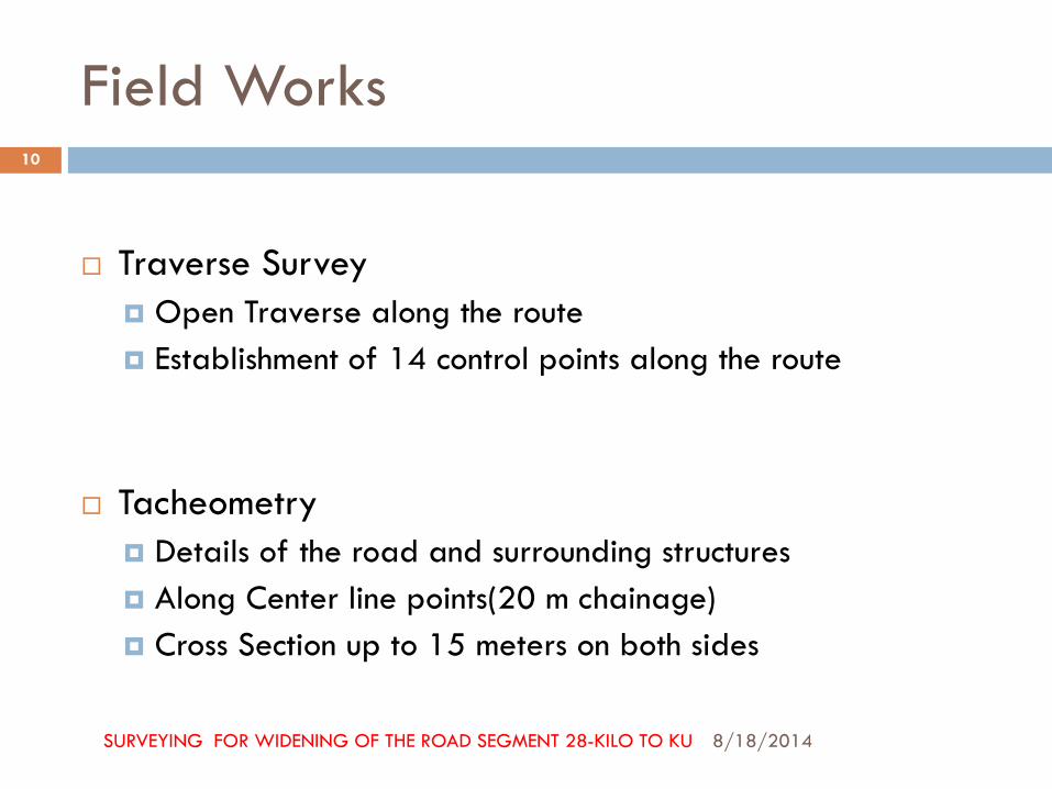
Field Works
Traverse Survey
Open Traverse along the route
Establishment of 14 control points along the route
Tacheometry
Details of the road and surrounding structures
Along Center line points(20 m chainage)
Cross Section up to 15 meters on both sides
8/18/2014
10
SURVEYING FOR WIDENING OF THE ROAD SEGMENT 28-KILO TO KU

8/18/2014 SURVEYING FOR WIDENING OF THE ROAD SEGMENT 28-KILO TO KU
11
Field Work Snapshots

Instruments Used in Data Acquisition
Theodolite Set
Staff
Ranging Rods
Measuring tape
8/18/2014
12
SURVEYING FOR WIDENING OF THE ROAD SEGMENT 28-KILO TO KU
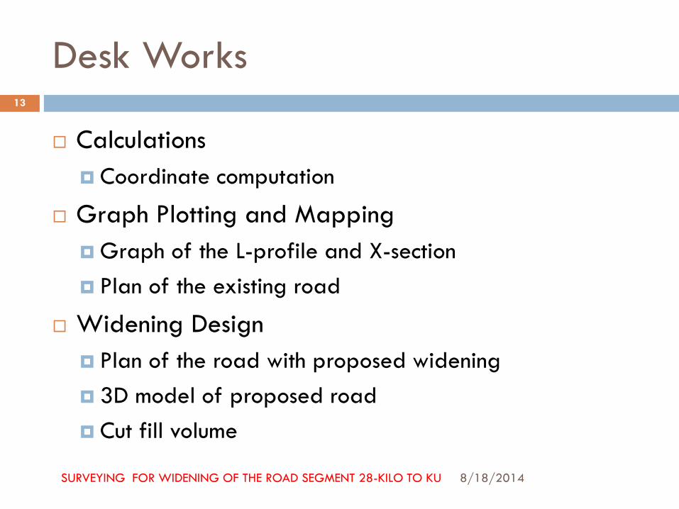
Desk Works
Calculations
Coordinate computation
Graph Plotting and Mapping
Graph of the L-profile and X-section
Plan of the existing road
Widening Design
Plan of the road with proposed widening
3D model of proposed road
Cut fill volume
8/18/2014
13
SURVEYING FOR WIDENING OF THE ROAD SEGMENT 28-KILO TO KU

8/18/2014 SURVEYING FOR WIDENING OF THE ROAD SEGMENT 28-KILO TO KU
14

8/18/2014 SURVEYING FOR WIDENING OF THE ROAD SEGMENT 28-KILO TO KU
15
8/18/2014 SURVEYING FOR WIDENING OF THE ROAD SEGMENT 28-KILO TO KU
16

8/18/2014 SURVEYING FOR WIDENING OF THE ROAD SEGMENT 28-KILO TO KU
17

8/18/2014 SURVEYING FOR WIDENING OF THE ROAD SEGMENT 28-KILO TO KU
18
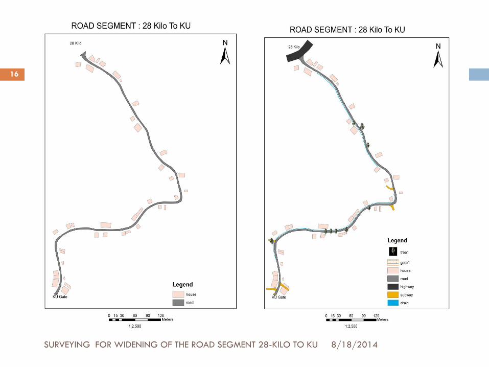
Existing road map With Buffer upto 15m

Software used
8/18/2014 SURVEYING FOR WIDENING OF THE ROAD SEGMENT 28-KILO TO KU
19
AutoCAD 2011
Arc GIS 9.x

OUTCOMES
Map of existing
road
8/18/2014
20
SURVEYING FOR WIDENING OF THE ROAD SEGMENT 28-KILO TO KU
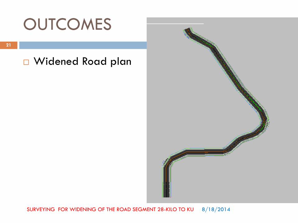
Widened Road plan
8/18/2014
21
SURVEYING FOR WIDENING OF THE ROAD SEGMENT 28-KILO TO KU
OUTCOMES

OUTCOMES
8/18/2014 SURVEYING FOR WIDENING OF THE ROAD SEGMENT 28-KILO TO KU
22
3D Model

OUTCOMES
8/18/2014 SURVEYING FOR WIDENING OF THE ROAD SEGMENT 28-KILO TO KU
23
L-Profile of Existing Road

OUTCOMES
8/18/2014 SURVEYING FOR WIDENING OF THE ROAD SEGMENT 28-KILO TO KU
24
L-Profile of Proposed Road

OUTCOMES
8/18/2014 SURVEYING FOR WIDENING OF THE ROAD SEGMENT 28-KILO TO KU
25
Cross Section of Proposed Road

OUTCOMES
8/18/2014 SURVEYING FOR WIDENING OF THE ROAD SEGMENT 28-KILO TO KU
26
Sectional View of Proposed Road

OUTCOMES
8/18/2014 SURVEYING FOR WIDENING OF THE ROAD SEGMENT 28-KILO TO KU
27
A1
A2
A3
A4
Cut Volume =((A1+A2)/2)*
chainage length
Fill Volume=((A3+A4)/2)*
chainage length
Sample:
A1=31.3950 sq. m
A2=23.9423 sq. m
A3=35.2637 sq. m
A4=12.1194 sq. m
Chainage Length= 20 m
Cut Volume=553.373
cubic. m
Fill Volume=473.831
cubic. m
C.L

OUTCOMES
8/18/2014 SURVEYING FOR WIDENING OF THE ROAD SEGMENT 28-KILO TO KU
28
Number of Houses that have to be destroyed=39

8/18/2014
29 SURVEYING FOR WIDENING OF THE ROAD SEGMENT 28-KILO TO KU
TIME SCHEDULE
Activities Working weeks
1st 2nd 3rd 4th 5th 6th 7th 8th 9th 10th 11th
Introduction,
Proposal
presentation
Literature
review
Data collection
Mid-Term
Presentation
GIS mapping
Widened designing
Report preparation
and
Final Presentation

Conclusion
The project has been completed in the specified
time
The objectives have been fulfilled
Kathmandu University can utilize these outcomes in
future for its further development
8/18/2014
30
SURVEYING FOR WIDENING OF THE ROAD SEGMENT 28-KILO TO KU

REFERENCES
8/18/2014 SURVEYING FOR WIDENING OF THE ROAD SEGMENT 28-KILO TO KU
31
Arora, K.R., Surveying Volume I “Traverse Survey”,
“Tacheometric Survey”
Agore, R.K., Elements of Civil Engineering,
“Geometric Design of Road”
ITC, Principles of GIS
Thank You…
8/18/2014
32
SURVEYING FOR WIDENING OF THE ROAD SEGMENT 28-KILO TO KU