survey and assessment of seagrass beds in the gulf of ... · pdf filetamil nadu) 3 title...
TRANSCRIPT

Survey and assessment of seagrass beds in
the Gulf of Mannar and Palk Bay to support
strategy to conserve and manage seagrass
habitats
Suganthi Devadason Marine Research Institute (SDMRI)
November 2011 - February 2013
A Cuttlefish swims amongst the seagrass beds in Palk Bay © MFF/SDMRI
2
This report has been designed and published by Suganthi Devadason Marine
Research Institute (SDMRI)
Produced with the financial support of Danida, Norad and Sida
Citation: SDMRI, Study and assessment of seagrass beds in the Gulf of Mannar and
Palk Bay to support strategy to conserve and manage seagrass habitats
All rights reserved. No part of this publication may be reproduced in any form or by
any means without the prior permission of the IUCN and MFF. The designation of
geographical entities in this report, and presentation of the material, do not imply the
expression of any opinion whatsoever on the part of International Union for
Conservation of Nature and Natural Resources (IUCN) or The Mangroves for the
Future (MFF) Initiative concerning the legal status of any country, territory, or area, or
of its authorities, or concerning the delimitation of its frontiers or boundaries. The
views expressed in this publication do not necessarily reflect those of IUCN or the
MFF Initiative, nor does citing of trade names or commercial processes constitute
endorsement.
Available from: IUCN India Country Office (New Delhi) and from SDMRI (Tuticorin,
Tamil Nadu)

3
Title Survey and assessment of seagrass beds in the Gulf of
Mannar and Palk Bay to support strategy to conserve and
manage seagrass habitats – Final Report
Author Nisha D’Souza, Dr. J.K Patterson, Dr. N.M. Ishwar (IUCN India Country Office; SDMRI)
Date created 2013-08-20
Main subject Final Report
Keywords Seagrass, Dugong, Palk Bay, Gulf of Mannar
Purpose Final small grant project report
Summary As given below
Distribution MFF India; NCB India
Date distributed
2013-08-31
4
Contents
Introduction Page 4
Methodology Page 5
Assessment of current status of seagrass habitats in Gulf of Mannar and Palk Bay
Page 5
Informal discussions to identify fishery-related threats to seagrass habitats
Page 7
Stakeholder discussions and capacity building of fisher folk, in particular youth, in reporting dugong sightings
Documenting threats to Dugongs through targeted surveys Page 8
Development of knowledge products on dugongs and seagrass
Page 8
Results and Discussion
Assessment of current status of seagrass habitats in Gulf
of Mannar and Palk Bay
Page 9
Recommendations for a strategy for conservation and
management of seagrass beds in the Gulf of Mannar and
Palk Bay
Page 10
Documenting threats to Dugongs through targeted surveys Page 12
Challenges Page 13
Recommendations for Future Research Page 14
References Page 14
Annexes 1 - 6 Pages 14 - 29

5
Introduction
Seagrass meadows are specialized marine flowering plants that have adapted to
near shore underwater environments. Forming extensive meadows, they support
high levels of biodiversity, stabilize sediments and trap heavy metals and nutrient rich
runoff, thereby improving the water quality for large numbers of associated coral reef
communities. They are important nursery habitats for fishes and feeding grounds for
endangered species such as turtles and dugongs, the latter for who the presence of
seagrass is highly correlated with its ability to survive. Additionally, seagrass rhizome
systems bind and stabilize bottom sediments and provide habitats for hundreds of in-
faunal organisms.
Seagrasses are amongst the least understood marine ecosystems in India. Seagrass
beds in the country are predominantly found in mudflats and sandy regions along
open shores and in island lagoons, from the lower intertidal zone to a depth of
approximately 10–15m (Jagtap, 1991, Ramamurthy et al., 1992). The major
seagrass meadows are distributed amongst the Lakshadweep and Andaman and
Nicobar Islands and along the southeast coast of India, in the Gulf of Mannar and
Palk Bay. It is estimated that the maximum extent (3,000ha) of seagrass are found in
the latter region; fourteen species of seagrass have been conclusively identified in
the region (Jagtap and Inamdar, 1991).
The Gulf of Mannar extends from Rameswaram Island in the north to Kanyakumari in
the south. It consists of a chain of 21 islands stretching from Mandapam to Tuticorin.
The islands are located approximately 2 - 10km from the mainland and are classified
based on their proximity to mainland into four major groups Tuticorin, Vembar,
Keezhakkarai and Mandapam groups. The region was declared a Marine Biosphere
Reserve in 1989 under the Man and Biosphere Programme of UNESCO in lieu of its
invaluable biodiversity and multiple use status. The 21 islands are protected under
the Gulf of Mannar Marine National Park. In previous years, area estimates of
seagrass beds from different regions were generally made from aerial photographs,
ground survey, and naval hydrographic charts, whereas standing crop was
calculated by using biomass data collected by line transect and quadrat methods.
By comparison to the adjacent Gulf of Mannar, the Palk Bay region has not been
paid much attention and most of the available literature and studies do not reflect the
current scenario. In general, the distribution pattern of seagrass has been observed
to be relatively close to that of most tropical and subtropical regions in terms of
distribution and abundance (Jagtap and Untawale, 1989, Jagtap, 1987, 1991).
Globally, there has decrease in seagrass abundance and associated organisms,
mainly due to anthropogenic activities (Kemp 2000). A number of countries have
given high priority to conserving seagrass ecosystems, and rehabilitation programs
have been implemented since 1945 in some areas (Thorhaug 1986). Seagrass beds
from India have been included as ecologically sensitive regions and are protected by
the Coastal Regulation Zone Act. Despite this seagrasses, and associated fauna like
dugongs (a highly endangered Sirenian species, dugongs are afforded the highest
protection under the Wildlife Protection Act, 1972, in India; very little is known about

6
them), have been largely left out of education, research, and management
consideration, as compared to other ecologically sensitive habitats such as
mangroves and coral reefs.
The objectives of this project are to develop a long-term strategy for seagrass
conservation in the Gulf of Mannar and Palk Bay and to enhance knowledge of
dugongs in the region. This will be achieved through
Assessment of current status of seagrass habitats in Gulf of Mannar and Palk
Bay
Informal discussions to identify fishery-related threats to seagrass habitats
Stakeholder discussions and capacity building of fisher folk, in particular
youth, in reporting dugong sightings
Documenting threats to Dugongs through targeted surveys
Development of knowledge products on dugongs and seagrass
Methodology
Assessment of current status of seagrass habitats in Gulf of Mannar and Palk
Bay
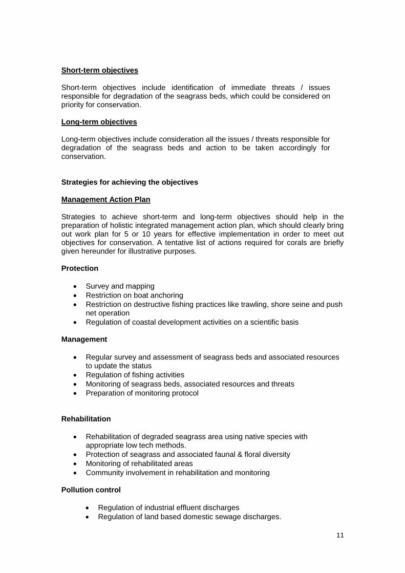
Study sites
A preliminary visual survey was carried out to identify the location and extent of sea
grass meadows in the Gulf of Mannar, in the area outside of the Marine National
Park between Rameswaram and Tuticorin,(please refer to Figure 2). Similar surveys
were conducted in Palk Bay from Thondi to Athiramapattinan (please refer to Figure
3). The Palk Bay area was demarcated using GPS coordinates, into eleven separate
sites, in relation and close proximity to villages along the coastline. For a table of
GPS coordinates of all sites and associated maps, please refer to Annex 1.
Figure 1. Surveyed sites for MFF project in the Gulf of Mannar

7
Seagrass assessments
Assessments of the seagrass beds were conducted as per the methodology detailed
in English et al. (1997). 100m Line Intercept Transects (LIT) were laid down
perpendicular to the shoreline and parallel to each other at a distance between 50 –
100m. 1 x 1m quadrats (with 10cm grids) were placed along either side of each
transect at 5m intervals. Percentage seagrass species composition and density,
shoot density and seagrass biomass were assessed. Number of transect differed
between sites depending on the extent of seagrass beds. For more detailed
information please refer to Annex 2.
Assessments in the Gulf of Mannar were conducted from January to April 2012.
Assessments in Palk Bay were conducted from June to September 2012. This was
timed as such because rough weather prevails in the Gulf of Mannar between April
and September and in Palk Bay between October and March, that endangers divers.
Shoot density
Shoot density was measured by counting the number of leaf meristems (points of
leaf initiation on the shoot) of individual seagrass species within each of the afore-
mentioned quadrats. The shoot density was averaged along each transect.
Above ground biomass
Leaves, roots and rhizomes were collected by hand from within 4 random quadrats
per transect. The samples were rinsed clean of adhering debris, sand and epiphytes
and separated species-wise. Each set of species samples were divided into leaves,
rhizomes and roots for the biomass study. Each portion was blotted to remove
excess water and dried at 30°C to a constant weight. The biomasses were weighed
for each species and averaged along each transect.
Figure 2. Surveyed sites for MFF project in Palk Bay

8
Research was further simultaneously carried out on the % composition and biomass
of specific species of bottom dwelling fauna, epifauna and epiphytes, as well as fish
densities. Although this does not form part of the project activities and this report, as
it requires long term data collection which will continue to be collected beyond the
scope of this small grant project, whatever raw data was collected within the period
of the project has been provided to MFF India and IUCN India Country Office. It is
envisioned that in combination with the data collected through this project and the
data collected previously by SDMRI, a comprehensive understanding of the seagrass
habitats within the entirety of the Gulf of Mannar and Palk Bay ecosystem can be
developed and subsequent scientific papers published.
Informal discussions to identify fishery-related threats to seagrass habitats
Informal discussions were had with all encountered active fishermen at all of the
study sites in Gulf of Mannar and Palk Bay to identify what they regarded as most
threatening to the seagrass beds. The recorded list is provided in Annex 3.
Stakeholder discussions and capacity building of fisher folk, in particular
youth, in reporting dugong sightings
Trainings were conducted in four coastal villages (two in Palk Bay and two in Gulf of
Mannar). The trainees were youth from fisher communities, predominantly males, as
they are the most active fishers in these coastal regions. In MunaiKadu, a few
fisherwomen also participated in the training as they are involved in the seaweed
collection around the island areas.
Village Date of Training No. of participants
1. MunaiKadu (Palk Bay) 26.02.2013 25
2. VadaKarai (Palk Bay) 26.02.2013 28
3. Vethalai (Gulf of Mannar) 27.02.2013 29
4. IyanarKoil (Gulf of Mannar) 27.02.2013 25
The training was designed to ensure that a data base of dugongs in the region is
maintained by involving the local fishing communities. It is envisioned that the data
can be accessed to estimate dugong population size and status and to identify
possible management techniques that can be adopted to protect this critically
endangered and iconic animal. The following was taught during the training:
How to gather and store relevant information pertaining to sightings of marine
mammals, particularly dugongs, on their daily fishing outing whilst maintaining
a mandated 2m distance from the animal so as not to stress it out.
How to record, location of sighting, individual animal size, sex, scars and
period of time that the animal spent submerged.
Recording the behavior of sighted dugongs as per the following
classifications:
9
1. Feeding (movement of muzzles over sea grass resulting in ingestion of
food)
2. Idling (seemingly undirected activity on a small area).
3. Resting ( absence of any kind of movements)
4. Communicating (Sound emissions in form of squeaks and barks)
5. Direct behavior to observer
Documenting threats to Dugongs through targeted surveys
Communities from coastal villages and hamlets were selected for the survey based
on previous research documentation of dugong occurrence, and comprehensive
discussions with fisheries scientists and experts. As such, 46 coastal villages were
selected and surveyed from Tuticorin to Rameswaram in the Gulf of Mannar, and
from Mandapam up to Adhirampattinam in Palk Bay. Interviews were conducted
randomly with ten individuals at each village or hamlet. Of the 460 interviewees, 98%
were active fishermen (of ages ranging from 19 to 74 years) and 2% were officials
from the State Fisheries Department, fish buyers and vendors. A standard semi-
structured questionnaire including both closed and open-ended questions was
designed (adapted from Hines 2002, please refer to Annex 4 for the survey) and
translated into local languages for the interviews. The survey was conducted during
the month of February 2013.
Development of knowledge products on dugongs and seagrass beds
A brochure to raise awareness of dugongs was developed in the Tamil and
distributed to all surveyed villages. A copy has been attached to this report.
Results and Discussion
Assessment of current status of seagrass habitats in Gulf of Mannar and Palk
Bay
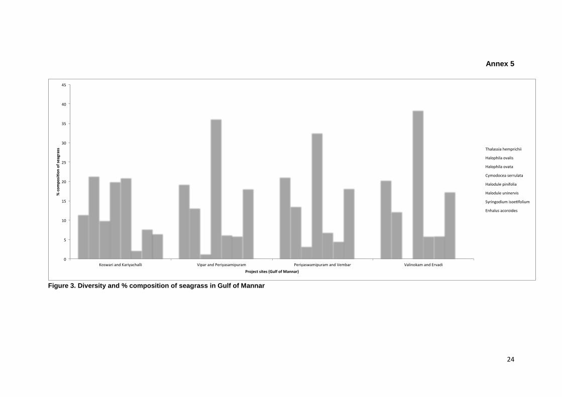
The seagrass beds at the study sites in the Gulf of Mannar comprised of eight
species (Figure 1, Annex 5). In three of the study sites (between Vipar and
Periyasamipuram, between Periyaswamipuram and Vembar, and between
Valinokam and Ervadi), Cymodocea serrulata was by far the most dominant species
(ranging from 36 -38%) with Thalassia hemprichii following behind. Halophila ovata
was the least dominant (ranging from 0 – 3.24%); the species was not found
between Valinokam and Ervadi. The two Halodule species were found in exceeding
low abundance (ranging from 4.5 – 6.9%). By stark contrast, between Koswari and
Kariyachalli, the seagrass compositional structure differed varied to the other three
sites. Three species dominated Cymodocea serrulata, Halophila ovalis and Halodule
pinifolia (at approximately 20% each). An eighth species, Enhalus acoroides (not
found in any other of the other sites) was also observed. Halodule uninervis had the
least coverage in the site (at 2.2%).
Between Koswari and Kariyachalli shoot density was highest for the species
Cymodocea serrulata with 183.65 m-2 followed by Thalassia hemprichii with 56.39 m-
2. Biomass was also highest for the species Cymodocea serrulata with 101.14 g dry
10
weight m-2 followed by Thalassia hemprichii with 24.31 g dry weight m-2. Between
Vipar and Periyasamipuram shoot density was highest for the species Cymodocea
serrulata with 180.41 m-2 followed by Thalassia hemprichii with 52.07 m-2. Biomass
was also highest for the species Cymodocea serrulata with 112.03 g dry weight m-2
followed by Syringodium isoetifolium with 28.79 g dry weight m-2. Between
Periyaswamipuram and Vembar shoot density was highest for the species
Cymodocea serrulata with 159.23 m-2 followed by Thalassia hemprichii with 62.75 m-
2. Biomass was also highest for the species Cymodocea serrulata with 99.49 g dry
weight m-2 followed by Thalassia hemprichii with 23.82 g dry weight m-2. Between
Valinokam and Ervadi shoot density was highest for the species Cymodocea
serrulata with 136.5 m-2 followed by Thalassia hemprichii with 56.64 m-2. Biomass
was also highest for the species Cymodocea serrulata with 94.98 g dry weight m-2
followed by Thalassia hemprichii with 22.92 g dry weight m-2 (Figure 3, Annex 5)
Previous studies indicate (Japtap, 1996) that species of Halodule and Halophila
occurred in higher frequencies in the intertidal and shallow seagrass beds of the Gulf
of Mannar, whereas Cymodocea serrulataand Thalassia hemprichii showed greater
frequencies in the depth range of 3 – 5m and 7 – 8m respectively. This contrasted
with the results of the present study in that it was observed that Cymodocea serrulata
was consistently present in all seagrass beds regardless of depth or distance from
shore of the seagrass bed. However, the pattern that Jagtap (1996) found, appears
to be consistent with seagrass composition in Koswari and Kariyachalli. This could
attributed to the fact that since the site is not as exposed to the open sea, it is
protected from strong waves and currents, enabling a greater diversity of seagrass to
grow (Manikandan et al., 2011).
The seagrass beds at the study sites in Palk Bay comprised of six species (Figure 2,
Annex 5)). Cymodocea serrulata had the most dominant coverage followed by
Syringodium isoetifolium, at all eleven sites. Halophila decipiens has the least
coverage in all sites. Moving from east to west along the coast, there is decreasing
presence of Halodule pinifolia and Halophila ovalis. At the majority of the 11 sites the
shoot density and biomass for Cymodocea serrulata was the highest, followed by
Thalassia hemprichii (Figure 4, Annex 5)
It is important to note that although the majority of species are the same between the
Gulf of Mannar and Palk Bay there are a few species that differ. Halophila decipiens
was only found in Palk Bay. Holophilia ovate, Halodule univeris and Enhalus
acoroides were found in the Gulf of Mannar but not Palk Bay. This insinuates that the
management plans for the region will need to differ in some aspects with regard to
ensuring that the varied floral diversity of the two regions is conserved. There are a
range of factors including depth, distance from shore, temperature and salinity, that
have not been investigated through this study, and that have been shown to affect
the distribution, diversity (seagrass species assemblage) and abundance.
Recommendations for a strategy for conservation and management of
seagrass beds in the Gulf of Mannar and Palk Bay
The short term and long term management strategies need to be implemented for the conservation and management of seagrass beds in Gulf of Mannar and Palk Bay.
11
Short-term objectives
Short-term objectives include identification of immediate threats / issues responsible for degradation of the seagrass beds, which could be considered on priority for conservation.
Long-term objectives
Long-term objectives include consideration all the issues / threats responsible for degradation of the seagrass beds and action to be taken accordingly for conservation. Strategies for achieving the objectives
Management Action Plan
Strategies to achieve short-term and long-term objectives should help in the preparation of holistic integrated management action plan, which should clearly bring out work plan for 5 or 10 years for effective implementation in order to meet out objectives for conservation. A tentative list of actions required for corals are briefly given hereunder for illustrative purposes.
Protection
Survey and mapping
Restriction on boat anchoring
Restriction on destructive fishing practices like trawling, shore seine and push net operation
Regulation of coastal development activities on a scientific basis Management
Regular survey and assessment of seagrass beds and associated resources to update the status
Regulation of fishing activities
Monitoring of seagrass beds, associated resources and threats
Preparation of monitoring protocol
Rehabilitation
Rehabilitation of degraded seagrass area using native species with appropriate low tech methods.
Protection of seagrass and associated faunal & floral diversity
Monitoring of rehabilitated areas
Community involvement in rehabilitation and monitoring
Pollution control
Regulation of industrial effluent discharges
Regulation of land based domestic sewage discharges.
12
Regulation of fishing harbor activities
Regulation of coastal developmental activities
Regulation of aquaculture and slat pan waste discharges Environmental Monitoring
Monitoring of environmental parameters (Water and Sediment Quality) in seagrass bed areas
Monitoring of pollution level Socio-economic development through community participation
Skill development programmes to local community
Training in Eco-friendly fishing practices
Regular surveys to be conducted on the socioeconomics of the local people
Viable and site additional livelihood options to seagrass dependent coastal community
Formation of village level conservation and management committees Awareness building
Local workshop to create awareness among coastal community
Publication of brochures, posters and education materials to make aware all stakeholders including conservation managers, administrators, judiciary, political leaders etc.
Awareness creation through electronic media. Capacity building
Training of management staff
Capacity building of local research institutions for assessment, and monitoring
Capacity building of local community in seagrass rehabilitation Legislative and administrative measures
Steps to provide appropriate conservation status to seagrass bed areas in Palk Bay and Gulf of Mannar
Documenting threats to Dugongs through targeted surveys
Based on the data collected, it is evident that the dugong population in the Gulf of
Mannar still persists; the offshore waters of Mottaigopuram, Vellaipatti, Sippikulam,
Vaipar, Vembar, Erwadi, Keezhakarai, Pamban, Mandapam, Vedhalai, Muthupet,
Periyapatnam in particular were identified as important nursing and feeding grounds.
Please refer to Annex 6 for more details. When respondents were asked if the local
dugong population was increasing, declining or stable, 60% of the respondents
based in the Gulf of Mannar were of the opinion that population was declining; some
further elaborated that there is a visible decline in dugong occurrence in areas where
they were commonly found as early as 15-20 years ago. 50% of the respondents
attributed the decline in population to trawling. A further 4% attributed the decline to
the destruction of seagrass habitat and 4% to natural disasters like tsunamis and

13
cyclones. 12% of the interviewed fishermen admitted that they had caught an animal
in their gill nets and deliberately killed it; 8% set the caught animal free, although
whether the animal survived or not is unknown. The majority of the respondents were
hesitant to answer questions related to the catching and killing of the animal, it was
observed that a significant number knew that the dugong was protected by law.
Based on the data collected, it is evident that the dugong population in Palk Bay
(Thoppukaadu to Adhirampatinm) still persists although 80% of the respondents
within Palk Bay agree that the population has dropped significantly in the past
decade. Please refer to Annex 6 for more details. Thoppukaadu, Uppur, Mullumunai,
Solaiyakudi, Thondi, Ammanisathiram and Mallipatinam were identified as having the
highest frequency of visiting dugongs and are believed to be key feeding grounds for
mothers and calves in particular. Dugongs have also been sporadically observed in
the offshore waters of Pirappannavalasai, Panaikulam, Palanivalasai,
Muthuregunathpuram, Nambuthalai, Kottaipatinam, Sethuvapatinam and
Senthalaivayal. The respondents attributed the decline in population to trawling
(60%), usage of large sized gill nets like shark nets (10%), hunting (20%), natural
disasters like tsunami and cyclones (5%) and destruction of seagrass habitats (5%).
8% admitted to catching dugongs in their gill nets and killing them; 2% claimed to
have freed caught animals. As in the Gulf of Mannar the majority of the respondents
were hesitant to answer questions related to the catching and killing of the animal, it
was observed that a significant number knew that the dugong was protected by law
Attitudes to the need for conservation and sustainable use of natural resources,
specifically dugongs and seagrass, differed between the two regions Gulf of Mannar
and Palk Bay, with respondents from the latter believing it was more important. When
questioned as to what they thought should be done to conserve natural resources,
the majority suggested a decrease in trawling. Please refer to Annex 6 for more
details.
Challenges
Due to time constraints and unavailability of local authorities and state forest officials
to attend meetings, it was impossible to conduct stakeholder discussions to finalise
the draft the strategy plans for conservation of seagrass in the region. It is intended
that the data collected through this study will be published in an accredited scientific
journal to further support the strategy document, following which SDMRI with support
from MFF India will officially disseminate the document to relevant stakeholders for
review.
There were some delays in data collection due to rough weather. In Gulf of Mannar,
Rough weather prevails between April and September and this will have hindrance in
data collection in the field. In Palk Bay, Rough weather prevails between October
and March and this will have hindrance in data collection in the field.
Recommendations for future research
14
The overall results of this study indicate the need for rehabilitation of the once
abundant seagrass meadows in this region. As the coastal population grows with a
marked increase in dependence on marine and coastal resources, we must restore
these valuable nurseries for commercially important organisms, to serve our own
needs and the needs of some of the poorest communities in south India. As such
comprehensive research must be conducted, where lacking on the following aspects:
Fishing patterns in the region (both artisanal and mechanized), with particular
relevance to the exploitation and stress of their impact on seagrass and
related fauna.
The effects of patch size on diversity, abundance and composition of fauna.
Whilst continuous, extensive seagrass meadows are recognized for their
importance in providing refuge for a variety of organisms, vegetated patches
have not been widely investigated. Habitat patch size can be an important
determinant influencing species diversity and biological interactions among
species.
Seasonal differences can strongly influence the salinity, temperature and
other abiotic factors within the seagrass habitat. As such, the diversity,
composition and abundance of seagrass beds within the region could be
constantly (and perhaps naturally) changing over time; this will likely require
differing management efforts and actions at different periods of time.
Identification of suitable sites for rehabilitation and plantation of seagrass and
established protocols for the same.
References
1. Jagtap, T.G. 1991. Distribution of Seagrasses along the Indian coast. Aquat.
Bot., 40: 379-386.
2. Ramamurthy, K., N.P. Balakrishnan, K. Ravikumar and R. Ganesan, 1992.
Seagrasses of Coromandel coast, India. Flora of India – Series 4, Botanical
Survey of India, 80 p.

15
Annex 1
GPS coordinates and maps for surveyed project sites in Gulf of Mannar and
Palk Bay (2007 - 2012)
Gulf of Mannar
Name of the area GPS Mark
1. Vaan 080 50.223'N 780 12.089'E
2. Koswari 080 52.336'N 780 13.039'E
3. Kariyachalli 080 57.359'N 780 14.424'E
4. Vilanguchalli 080 56.222'N 780 15.589'E
5. Upputhanni 090 05.446'N 780 29.701'E
6. Puluvinichalli 090 06.200'N 780 32.046'E
7. Nallathanni 090 06.468'N 780 34.408'E
8. Anaipar 090 09.269'N 780 41.464'E
9. Valimunai 090 09.379'N 780 43.536'E
10. Poovarasanpatti 090 09.373'N 780 45.145'E
11. Appa 090 10.084'N 790 49.186'E
12. Thalayari 090 11.059'N 780 54.514'E
13. Valai 090 11.184'N 780 56.246'E
14. Mulli 090 11.262'N 780 57.515'E
15. Hare 090 12.233'N 790 04.118'E
16. Manoli 090 13.077'N 790 07.476'E
17. Manoliputti 090 13.164'N 790 09.007'E
18. Poomarichan 090 14.350'N 790 10.480'E
19. Pullivasal 090 14.380'N 790 11.449'E
20. Krusadai 090 14.588'N 790 12.423'E
21. Shingle 090 14.449'N 790 14.141'E
Palk Bay
Name of the area GPS Mark
1. Pasipattinam 090 47.426'N 790 04.183'E
2. R. puthur 090 53.132'N 790 07.267'E
3. Kottaipattinam 090 58.284'N 790 11.502'E
4. Kattumavadi 100 03.307'N 790 15.098'E
5. Sampaipattinam 100 13.202'N 790 16.189'E
6. Senthalaivayal 100 12.261'N 790 16.242'E
7. Ammanisathiram 100 14.199'N 790 16.212'E
8. Kaarankuda 100 14.414'N 790 16.405'E
9. Sethupavasathiram 100 15.016'N 790 17.046'E
10. Mallipattinam 100 16.455'N 790 19.135'E
11. Athiramapattinam 100 18.368'N 790 22.478'E

16
17
18
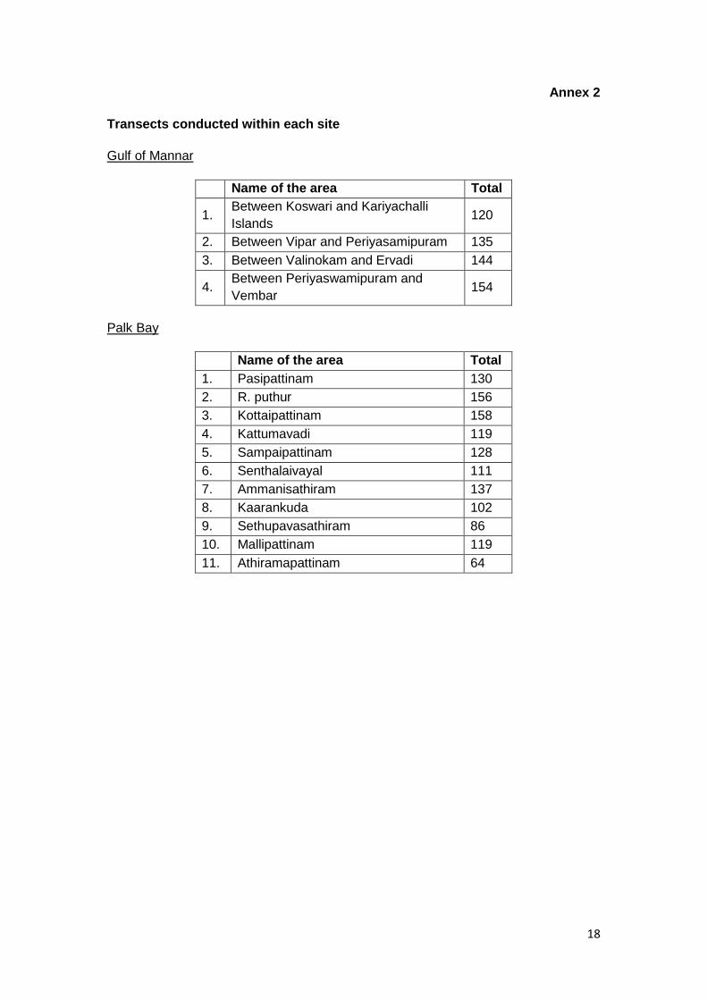
Annex 2
Transects conducted within each site
Gulf of Mannar
Name of the area Total
1. Between Koswari and Kariyachalli
Islands 120
2. Between Vipar and Periyasamipuram 135
3. Between Valinokam and Ervadi 144
4. Between Periyaswamipuram and
Vembar 154
Palk Bay
Name of the area Total
1. Pasipattinam 130
2. R. puthur 156
3. Kottaipattinam 158
4. Kattumavadi 119
5. Sampaipattinam 128
6. Senthalaivayal 111
7. Ammanisathiram 137
8. Kaarankuda 102
9. Sethupavasathiram 86
10. Mallipattinam 119
11. Athiramapattinam 64

19
Annex 3
Fishery-related threats to seagrass habitats
Gulf of Mannar
Between Koswari and Kariyachalli
Islands
Inshore trawling
Shore seine operation
Bottom gill net operation
Boat anchoring
Sedimentation
Between Vipar and
Periyasamipuram
Inshore trawling
Shore seine operation
Bottom gill net operation
Boat anchoring
Sedimentation
Grazing
Between Valinokam and Ervadi
Inshore trawling
Shore seine operation
Bottom gill net operation
Boat anchoring
Sedimentation
Between Periyaswamipuram and
Vembar
Inshore trawling
Shore seine operation
Bottom gill net operation
Boat anchoring
Sedimentation
Palk Bay area
Pasipattinam
Inshore trawling
Bottom gill net
operation
Boat anchoring
Sedimentation
R. puthur
Inshore trawling
Bottom gill net
operation
Boat anchoring
Sedimentation
Kottaipattinam
Inshore trawling
Bottom gill net
operation
Boat anchoring
Sewage disposal
Sedimentation
Kattumavadi
Inshore trawling
Bottom gill net
operation
Boat anchoring
Sewage disposal
Solid waste dumping
Sedimentation
Sampaipattinam
Inshore trawling
Bottom gill net
operation
Boat anchoring
Sewage disposal
Solid waste dumping
Sedimentation
Senthalaivayal
Inshore trawling
Bottom gill net
operation
Boat anchoring
Sedimentation
Ammanisathiram
Inshore trawling
Bottom gill net
operation
Boat anchoring
Sewage disposal
Sedimentation
Kaarankuda
Inshore trawling
Bottom gill net
operation
Boat anchoring
Solid waste dumping
Sedimentation
Sethupavasathiram
Inshore trawling
Bottom gill net
operation
Boat anchoring
Sedimentation
Mallipattinam
Inshore trawling
Bottom gill net
operation

20
Boat anchoring
Sedimentation
Athiramapattinam
Inshore trawling
Bottom gill net
operation
Boat anchoring
Sedimentation

21
Annex 4
Dugong questionnaire (adapted using UNEP-CMS guidelines)
Name:
Age:
Gender:
Area:
Topography:
Demography:
Population size of the village:
Education of the respondent:
Occupation of the respondent:
Fishing labourer/Owner
Wage labourer
Skilled worker
Petty Trader
Self employed
No. of own boats:
More than 100 boats
50-100 boats
Less than 50 boats
Ports nearby(in nos.)
Large
Medium
Small
Fishing activities: (specification to Fishing depth, fishing grounds (past & now), time
and season)
Fishing activity (Past)
Fishing ground
Depth
Time & season
Fishing activity (Present)
Fishing ground
Depth
Time & season
Remarks
Fishing resources caught (sps. and tonnes/day)
Fishing activity
- Past
Fishing Activity
- Present
22
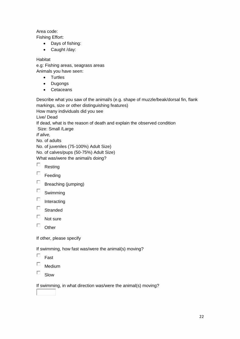
Area code:
Fishing Effort:
Days of fishing:
Caught /day:
Habitat
e.g: Fishing areas, seagrass areas
Animals you have seen:
Turtles
Dugongs
Cetaceans
Describe what you saw of the animal/s (e.g. shape of muzzle/beak/dorsal fin, flank
markings, size or other distinguishing features)
How many individuals did you see
Live/ Dead
If dead, what is the reason of death and explain the observed condition
Size: Small /Large
If alive,
No. of adults
No. of juveniles (75-100%) Adult Size)
No. of calves/pups (50-75%) Adult Size)
What was/were the animal/s doing?
Resting
Feeding
Breaching (jumping)
Swimming
Interacting
Stranded
Not sure
Other
If other, please specify
If swimming, how fast was/were the animal(s) moving?
Fast
Medium
Slow
If swimming, in what direction was/were the animal(s) moving?

23
If interacting, what was it with?
People
Vessels
Fishing gear
If swimming, how fast was/were the animal(s) moving?
Fast
Medium
Slow
If interacting, what was it with?
People
Vessels
Fishing gear
Date of Sighting:
Time and duration of sighting:
Were you ...
On land
On a vessel
If on a vessel, what type was it?
Reported: Yes / No
Any further notes
Date of Survey:
24
Annex 5
0
5
10
15
20
25
30
35
40
45
KoswariandKariyachalli ViparandPeriyasamipuram PeriyaswamipuramandVembar ValinokamandErvadi
%composi
onofseagrass
Projectsites(GulfofMannar)
Thalassiahemprichii
Halophilaovalis
Halophilaovata
Cymodoceaserrulata
Halodulepinifolia
Haloduleuninervis
Syringodiumisoe folium
Enhalusacoroides
Figure 3. Diversity and % composition of seagrass in Gulf of Mannar

25
Figure 4. Diversity and % composition of seagrass in Palk Bay

26
Figure 5. Biomass and shoot density of seagrass in the Gulf of Mannar

27
Figure 6. Biomass and shoot density of seagrass in Palk Bay

28
Annex 6
Distribution and sightings of dugongs
Gulf of Mannar
S.No.
Study area
Gulf of Mannar Population freq (in nos.)
1 Thirespuram 2
2 Mottaigopuram 6
3 Vellaipatti 5
4 Tharuvaikulam 1
5 Pattinamaruthur 1
6 Sippikulam 4
7 Veipar 3
8 Vembar 3
9 Erwadi 4
10 Keezhakarai 2
11 Muthupettai 4
12 Periyapattinam 2
13 Vedhalai 8
14 Puthumadaam 1
15 Mandapam 5
16 Pamban 2
Palk Bay toAdhirampatinam
S.No.
Study area
Palk Bay - Adhirampatinam
Population size (in
nos.)
17 Thoppukaadu 12
18 Pirappannavalasai 3
19 Aathankarai 2
20 Panaikulam 3
21 Iraniyanvalasai 1
22 Palanivalasai 3
23 Muthuveerampatinam 2
24 Poosarinagar 2
25 Illanthakootam 2
26 Devipatinam 2
27 Muthuregunathapuram 3
28 Pathananthal 2
29 Karankadu 1
30 Thirupallakudi 1
31 Uppur 10
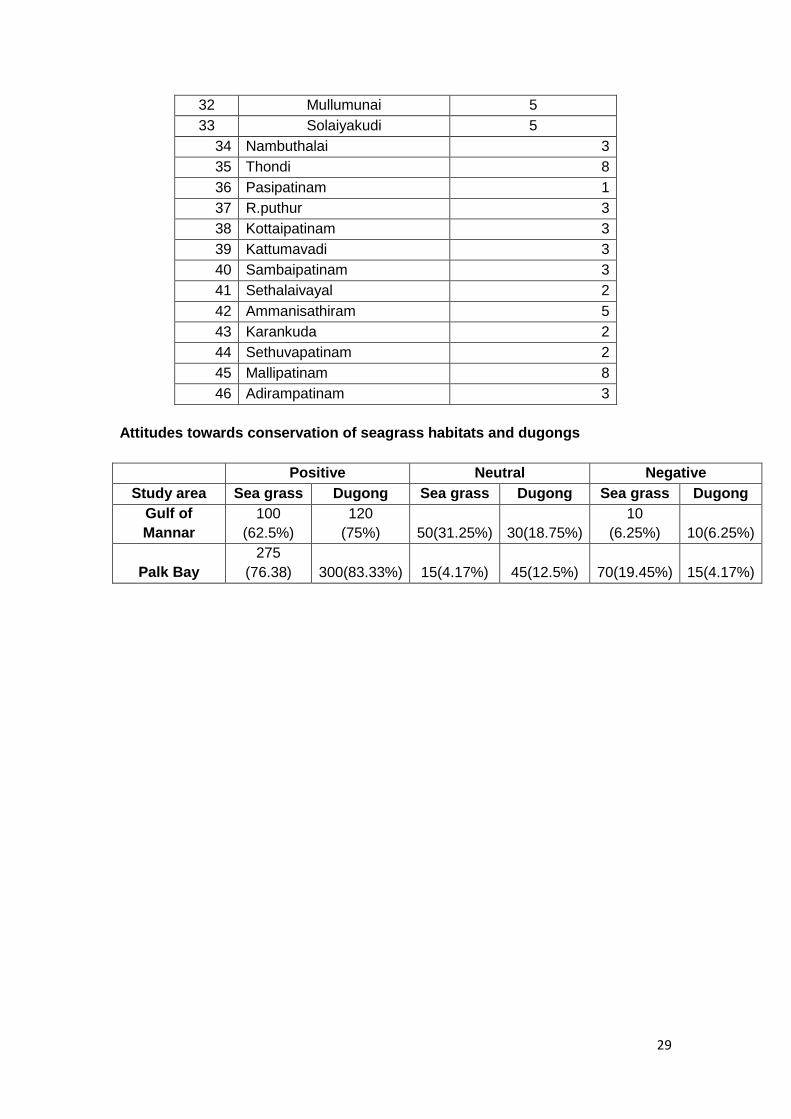
29
32 Mullumunai 5
33 Solaiyakudi 5
34 Nambuthalai 3
35 Thondi 8
36 Pasipatinam 1
37 R.puthur 3
38 Kottaipatinam 3
39 Kattumavadi 3
40 Sambaipatinam 3
41 Sethalaivayal 2
42 Ammanisathiram 5
43 Karankuda 2
44 Sethuvapatinam 2
45 Mallipatinam 8
46 Adirampatinam 3
Attitudes towards conservation of seagrass habitats and dugongs
Positive Neutral Negative
Study area Sea grass Dugong Sea grass Dugong Sea grass Dugong
Gulf of
Mannar
100
(62.5%)
120
(75%) 50(31.25%) 30(18.75%)
10
(6.25%) 10(6.25%)
Palk Bay
275
(76.38) 300(83.33%) 15(4.17%) 45(12.5%) 70(19.45%) 15(4.17%)