sunset landing concept harbor plan - chebeague …...2018/12/12 · option 1 provid es a full-...
TRANSCRIPT

Prepared for: Board of Selectmen
Town of Chebeague Island, Maine
04 December 2018
Sunset Landing Concept Harbor
Plan
Prepared by:
650 Islington Street, Suite 1 Portsmouth, NH www.collinsengr.com

Sunset Landing Concept Harbor Plan Chebeague Island, Maine
December 2018| Collins Engineers | MRLD 2
TABLE OF CONTENTS EXECUTIVE SUMMARY ............................................................................................................................................... 1 INTRODUCTION ........................................................................................................................................................ 2 SUNSET LANDING DESCRIPTION .................................................................................................................................. 4 SUNSET LANDING SITE SUMMARY ............................................................................................................................... 5 DIRECTIVES .............................................................................................................................................................. 9 OVERALL HARBOR PLAN OBJECTIVES ......................................................................................................................... 10 OPTION 1 – FULL SERVICE FACILITY SIMILAR TO STONE WHARF EAST COVE & WEST BUILD-OUT OPTION ............................ 10 OPTION 2 – REDUCED SERVICE FACILITY ..................................................................................................................... 17 ESTIMATED CONCEPT CONSTRUCTION COSTS .............................................................................................................. 23
APPENDIX LIST OF AVAILABLE ARCHIVE INFORMATION LIST OF ADDITIONAL AVAILABLE INFORMATION DESIGN CRITERIA
ATTACHMENTS
FIGURE G01 CONCEPTUAL LAYOUT – OPTION 1 FIGURE G02 CONCEPTUAL PIER LAYOUT – OPTION 1 FIGURE G03 CONCEPTUAL SITE LAYOUT – ALTERNATIVE 1 FIGURE G04 CONCEPTUAL LAYOUT – OPTION 2 FIGURE G05 CONCEPTUAL PIER LAYOUT – OPTION 2 FIGURE G06 CONCEPTUAL SITE LAYOUT – ALTERNATIVE 2 FIGURE G07 APPROXIMATE PROFILE BASELINE FIGURE G08 ALTERNATIVE 2 PROFILE GRADE

Sunset Landing Concept Harbor Plan Chebeague Island, Maine
December 2018| Collins Engineers | MRLD 1
EXECUTIVE SUMMARY
The Town of Chebeague Island (Town) is systematically evaluating the island’s coastal access needs and potential improvements on Great Chebeague Island. Currently, the Stone Wharf facility provides for the majority of the island’s passenger ferry and rescue transport services. The facility also includes infrastructure to support barging, commercial fishermen, annual slip rentals, and transient boating slips. Given the 200+ year age of the facility and estimated costs for improvements to serve the multi-uses, the Town identified the Sunset Landing property as a potential option for a new water transportation facility. Based on archive records, stakeholder and community input, review of the varied uses served by the facility, and with the direction of the Town’s Board of Selectmen, this plan presents two options for a conceptual harbor at Sunset Landing. Option 1 provides a full-service facility meeting the needs of commercial users (CTC ferry and water taxi), fisherman, recreational users, and boat/freight movement with an all tides barge/boat ramp separate from the pier facility. Option 2 provides a limited commercial-use facility meeting the needs of commercial users and boat/freight movement with an all tides barge/boat ramp separate from the pier facility. The plan provides a discussion of each option, a discussion of two upland parking facility alternatives, and conceptual cost estimates (Table A) for the Town’s consideration and comparison to proposed improvements at the Stone Wharf.
TABLE A
SUNSET LANDING CONCEPT HARBOR PLAN COST ESTIMATES SUMMARY*
Item Option 1 Option 2
Pier Construction
18’ wide $4,500 $2,850
30’ wide $6,300
56’ wide $10,250
Barge/Boat Ramp Construction $2,400 $2,400
Upland Construction
Alternative 1 $900 $900
Alternative 2 $1,600 $1,600
Dredging $50 $50
Design, Permitting, and Consulting Services $450 to $800 $350 to $400
Estimated Construction & Engineering $8,300 to $15,100 $6,550 to $7,300
* Costs in $1,000

Sunset Landing Concept Harbor Plan Chebeague Island, Maine
December 2018| Collins Engineers | MRLD 2
INTRODUCTION
The Town of Chebeague Island (Town) is systematically evaluating the island’s coastal access needs and potential improvements on Great Chebeague Island. Currently, the Stone Wharf facility provides for the majority of the island’s passenger ferry and rescue transport services. The facility also includes infrastructure to support barging, commercial fishermen, annual slip rentals, and transient boating slips. Given the 200+ year age of the facility and estimated costs for improvements to serve the multi-uses, the Town identified the Sunset Landing property as a potential option for a new water transportation facility1. The Sunset Landing property is approximately 8.5 acres located along the southwesterly shore of the island (Figures 1, 2) and was acquired by the Town in the early 1990s. Between 2014 and 2016, various site investigations were completed, and determined that the property could be developed.
Figure 1 –Location Map (Ref: Bing Maps)
1 Town of Chebeague Island, Maine Comprehensive Plan, Adopted at Town Meeting on June 4, 2011
Sunset Landing
Nor
th

Sunset Landing Concept Harbor Plan Chebeague Island, Maine
December 2018| Collins Engineers | MRLD 3
Figure 2 –Sunset Landing Shoreline Topography
The Town was awarded a Shore and Harbor Grant through the Maine Coastal Program to develop a conceptual harbor plan for Sunset Landing using the previously attained site data with supplemental site investigations. The harbor plan is to develop a conceptual water transportation facility that includes a pier, barging facility, parking, coastal access, preservation of the identified archaeological sites, and possibly open space. The findings of the harbor plan will be used by the Town to determine infrastructure investments between rehabilitating Stone Wharf and constructing a new facility at Sunset Landing.
Nor
th
Sunset Landing

Sunset Landing Concept Harbor Plan Chebeague Island, Maine
December 2018| Collins Engineers | MRLD 4
SUNSET LANDING DESCRIPTION2
Sunset Landing is located on the southwestern portion of Chebeague Island, north of Indian Point and south of Seal Ledge. It is bounded on the north by privately-owned residential property; on the east by Great Cove Road; and on the south by privately-owned residential property. The parcel consists of gentle to moderate sloping topography and is generally wooded with limited open/grassy areas. There is some exposed bedrock, particularly along the shoreline with increasing bedrock exposure to the north. A small beach area is in the southwestern corner and central section of the parcel. There is archeological evidence of previous structures and habitation within the central portion of the parcel, and the remains of a pier from the Maquoit Ferry (Photograph 1).
Photograph 1 –Maquoit Ferry at Sunset Landing, 19153
2 Information from a 4 June 2014 wetlands delineation and soils report by Albert Frick Associates, Inc., and from Archaeological Survey Report – Sunset Landing Project, Tetra Tech, Inc. October 2015. 3 Maine Memory Network Website.

Sunset Landing Concept Harbor Plan Chebeague Island, Maine
December 2018| Collins Engineers | MRLD 5
SUNSET LANDING SITE SUMMARY
The following site and environmental investigations were completed as part of an initial site evaluation started in 2014, and are summarized as follows, with important considerations for the planning process highlighted. Chebeague Island Eelgrass Survey, Normandeau Associates, October 2014. The report indicated that
eelgrass is located approximately ~100’ to 350’ offshore for the length of the property and,
Eelgrass is highly protected as a “Special Aquatic Site” in US Army Corps of Engineers regulations and as a Coastal Wetland under Maine Department of Environmental Protection’s Natural Resource Protection Act.
Archaeological Survey Report – Sunset Landing Project, Tetra Tech, Inc. October 2015. The report identified a number of archeological features including a historic cellar hole located within the northeast portion of the site; a cellar hole depression within the central portion of the site; a historic well located in the south portion of the site; a prehistoric midden located in the southwest portion of the site (along the shoreline); and a former pier located in the west portion of the site (along the shoreline).
Sunset Landing Property Wind and Wave Analysis, Roberge Associates Coastal Engineers, LLC, November 2015. The analysis indicated that wind directions are predominantly from the south to the northwest with seasonal variations. South to northwest winds can develop waves from 1’ to 3’ in the spring/summer, and southwest to northwest winds can develop waves from 5’ to 7’ in the fall/winter.
Phase 2 Summary Report – Sunset Landing Evaluation, Milone & MacBroom, Inc. January 2016. The following provides a summary of the report.
o Survey
Completed in October 2014 by Nadeau Land Surveys, Inc., does not include bathymetric contours.
o Wetlands
The southwest wetlands are not considered Wetlands of Special Significance as defined by the Maine Department of Environmental Protection. The northeast wetlands are close to the 250’ shoreland zone and will likely be classified as Wetlands of Special Significance.
o Paper Streets
The paper street identified as “Elizabeth Road” is the only one depicted as there was “insufficient evidence” to show others.
o Historic Preservation Commission
MMI directed Tetra Tech to coordinate with Maine Historic Preservation Commission (MHPC). The MHPC identified two sites, a cellar hole and a prehistoric shell midden. Results from the Tetra Tech work include recommendations to maintain a 50’ buffer around the cellar hole sites.

Sunset Landing Concept Harbor Plan Chebeague Island, Maine
December 2018| Collins Engineers | MRLD 6
o Bathymetric Survey
Originally completed by the State of Maine as part of the Coastal Communities Program, however the quality of the data received was questionable and the area covered by the survey was inadequate4.
o Eelgrass Beds5
Per the MMI report,
It will be important that any proposed activity that will impact an eelgrass bed be designed so that the impacts are the least amount that is practical. This includes crossing at the shortest distance and locating any floating dock components beyond the extent of the eelgrass beds, rather than over them.
o Zoning
There are three separate zoning districts within the property.
Area within 125’ of the Highest Annual Tide (HAT) elevation is zoned Commercial Fishers/Maritime Activities (CFMA), allows for a range of water-dependent use;
Area within 250’ of the HAT and not within the CFMA is zoned as Limited Residential, does not allow for commercial or industrial uses; and
The remaining property is located within the Island Residential district, which allows a broad range of residential, agricultural and commercial fishing uses.
Existing Conditions Plan – Sunset Landing Property, Milone & MacBroom, Inc. March 2016. This is an update of the 2014 survey and includes the State’s bathymetric survey, notes regarding plan references, locus deed references, and study references (discussed above).
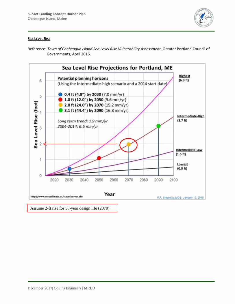
Town of Chebeague Island Sea Level Rise Vulnerability Assessment, Greater Portland Council of Governments, April 2016. Report indicates that the probable sea level rise will be 2’ in 50 years.
The following summarizes the 15 August 2018 stakeholder meeting and discussions. Existing Site Conditions
Collins confirmed that the Sunset Landing Committee’s documents have been shared by the Town and are part of the existing site conditions information.
Stakeholder requested review of the CFMA applicability to the site and suitability of the upland for the CFMA overlay.
Stakeholder commented that the Existing Conditions plan provided for the meeting was not the same as the March 7th reference survey from Milone & McBroom under the previous Sunset Landing Committee because Milone & MacBroom modified the survey after the surveyor provided the electronic file to Milone & MacBroom.
4 Electronic surveys were updated by Collins to include a bathymetric survey completed in early spring, 2018 by their subconsultant, Nadeau Land Surveys, Inc. 5 Chebeague Island Eelgrass Survey, Normandeau Associates, October 2014

Sunset Landing Concept Harbor Plan Chebeague Island, Maine
December 2018| Collins Engineers | MRLD 7
Wind-Wave Conditions
W, NW, and N winds are similar at Sunset as at Stone Pier, but Sunset does not benefit from protection afforded by Littlejohn Island and Cousins Island. (W winds at Stone Pier are broken up by Cactus Point and the Great Bar, at least at low tide.)
WNW wind at Sunset is not protected by Basket Island. The previous wave study was incorrect in assuming protection from Basket (anecdotally the author agreed but would not re-issue the study). True fetch for analysis should extend to the mainland shore.
Although the fetch distance as noted above may not be accurate, the attendees felt that the maximum wave heights identified in the previous report are appropriate, just not necessarily for the specific wind directions indicated in the report. Applying the indicated maximum wave heights from a westerly wind is likely more representative of the site conditions.
Ice Conditions
o Ice can pack in and out similar to Stone Pier.
o CTC does their own ice breaking at Stone Pier. USCG icebreaker was used during the 2014-2015 winter at Stone Pier, before that it is believed that USCG icebreaking was in the 1990s.
o At Sunset, the exposed bedrock to the north collects ice at low tide then releases it to flow south to the site. Then ice collects in the ‘hook’ to the south and eventually flows north again past the site.
o Dynamic aspects of accumulated ice are higher at Sunset versus Stone Pier. Accumulated ice is a concern.
o Bennett’s Cove is less susceptible to ice.
o Prior to the meeting, photographs of ice condition in March 2015 were forwarded to Collins.
Navigation Approach
o Ferry would approach form the north directly from Cousins Island ferry landing. The travel distance would not substantially increase over the current route.
o Barge would likely approach more from the south to southwesterly direction. It was unclear if the route would increase for barges that historically land at Bennetts Cove.
o Recreational boats and fishermen would approach from all directions.
o Designating an area for barge operations that is separate from the ferry operations would be easier.
o Ferry, barge and commercial fishing access is higher priority than small boats.
o Consider potential offshore transfer bridge similar to other islands, if the shoreline does not lend itself to a barge ramp solution.
o Consider a facility similar to the recently renovated facility on Long Island that dealt with many of the same issues as Chebeague.
o Solicit more input from the commercial fishermen.
o Collins confirmed that the barge accommodations are based on the CTC barge with consideration of the Lionel Plante barge.

Sunset Landing Concept Harbor Plan Chebeague Island, Maine
December 2018| Collins Engineers | MRLD 8
Upland Layout Considerations*
o Shallow/exposed bedrock along the top of bank and beyond.
o The Stone Pier plan projected parking needs of approximately 100 for year-round conditions for the 50-yr plan, plus additional for seasonal conditions.
o CTC emphasized that Milone & MacBroom indicated that Sunset could support 200 - 250 parking spaces. The alternatives for the concept harbor plan should include discussion for parking capacity of 250.
o Alternatives for the pier should consider drive-on access.
o The specific location of the access road is not part of the concept harbor plan, however estimated construction costs for an access road is part of the concept harbor plan. The concept plan will not discuss necessary easements or other issues centered around the access road location.
The following summarizes and clarifies discussions and comments during the 14 November 2018 stakeholder meeting (Public Forum Comments) that were not otherwise addressed at that time. Overall, there was a consensus that a user experience comparison to the Stone Wharf EAST COVE & WEST BUILD-OUT”6 (SW02) should be provided. Traffic management concerns
o Congestion at the drop off area
o Waiting times and places during the peak season
o Passenger vehicle interference with ramp traffic
o Travel distances from parking to boat stern
Study to provide the following information
o Profile grade drawings
o Walking distances (stern of boat to extreme parking)
o Costs for storm water management
o Discussion of pier length differences between Options 1 and 2
o ADA parking area with respect to total parking area
o Discussion of floating breakwater maintenance
Consider the following
o Drive on/drive off similar to stone wharf
o Locate the ramp to the north of the proposed pier location and relocate to minimize disruption to adjacent residences
o Increase staging ramp area
o Locate ramp turnaround as close as possible to ramp
6 Stone Wharf Master Plan, 31 December 2017.

Sunset Landing Concept Harbor Plan Chebeague Island, Maine
December 2018| Collins Engineers | MRLD 9
o A designated area for baggage and a covered area at the head of the wharf
o A sidewalk along upland parking
o A freight handling system whereby passengers need only drop freight off at the pier head and retrieve it once they reach the mainland
DIRECTIVES
The Chebeague Board of Selectmen (BoS) identified design directives and benchmark goals for the Sunset Landing Harbor including upland parking, the pier and the barge/boat ramp (ramp) in a 22 August 2018 Memorandum and in a 21 November 2018 memorandum. Two pier/ramp options and two upland parking alternatives were considered. It should be noted that the upland parking alternatives are applicable to either Option 1 or Option 2.
Option 1 – Full Service Facility (SL01)
From the 22 August 2018 Memorandum:
Configure to enable cost comparisons between similar designs at the Stone Wharf and Sunset, based on the “EAST COVE & WEST BUILD-OUT” (SW02). The estimated cost for planning purposes of 6.5 million dollars will be used to compare the cost of the same services at Sunset. Estimated capacities based on report and GoogleEarth™ measurements and components may be refined or altered as provided in Table 1.
From the 21 November 2018 memorandum:
Provide a comparable “user experience” to duplicate the services and experience provided by the ~$6.5M SW02. Implement the discussion items and suggestions provided during the 14 November 2018 public forum. Justify the reasons why the user experience cannot be duplicated or approximated.
o Consider 2-way traffic on double-wide wharf o Limit longest potential walk (from parking to boat) to 700’ o Provide a circular traffic flow queued at gangway, limit vehicle to boat distance to 125’ o Limit vehicle drop-off to gangway distance to 75’
Option 2 – Limited Commercial Facility (SL02)
From the 22 August 2018 Memorandum:
Configure to prioritize commercial operations and to accommodate all island barging traffic. Provide a dedicated staging area and optimized grading for the heaviest of barged vehicles such as concrete trucks.
From the 21 November 2018 memorandum: The plan can envision a more practical approach making design decisions to stay closer to the original target of $4.0M. The focus should be on pick up and drop off at the wharf head (pier entrance).
o Provide an emergency access gate at pier head

Sunset Landing Concept Harbor Plan Chebeague Island, Maine
December 2018| Collins Engineers | MRLD 10
o Limit traffic congestion at pier head o Limit personal freight handling and passenger waiting
OVERALL HARBOR PLAN OBJECTIVES Metrics used to guide planning in addition to meeting the directives and benchmark goals include: o Minimize eelgrass bed disturbance o Provide separate barge/boat ramp facilities o Minimize disturbance to archeological features o Prioritize commercial use o Minimize disturbance to designated wetlands o Consider 250 parking spaces o Accommodate wind/waves o Consider drive-on pier access o Accommodate ice o Improve public safety o Accommodate sea level rise o Improve traffic flow
OPTION 1 – FULL SERVICE FACILITY SIMILAR TO STONE WHARF EAST COVE & WEST BUILD-OUT OPTION Facility Location Public Forum Comments
o Locate the ramp to the north of the proposed pier location
o Locate ramp turnaround as close as possible to ramp
o Locate ramp to minimize disruption to adjacent residences
o Increase ramp staging area
The pier, barge/boat ramp (ramp) and parking facility are located in the southern portion of the property as governed by offshore bedrock outcrop locations, shoreline contours, and eelgrass beds (see Figures G01 and G02). The pier and ramp are oriented approximately perpendicular to the existing contours to limit regrading and earthwork. As shown in Figure G01 the extents of the eelgrass beds increase from the south to the north, with the narrowest strip occurring near the proposed layout. The ACOE7 has indicated that it assesses additional permitting fees due to eelgrass shadowing - construction of structures over eelgrass beds - ranging from $4 to $9 per square foot, which is evaluated on a case-by-case basis. As previously discussed, limiting disturbance to existing eelgrass beds is a high priority for the environmental permitting agencies. The ACOE has also indicated that dredging within eelgrass beds is highly discouraged. The proposed southerly location for the ramp is based on the sites general topography along the shoreline. The southwest portion of the site provides a more gradual inland slope which may be preferable from both a site development and end user perspective. The ramp would likely need to be located a minimum of 200’ north of the pier to accommodate the location of the recreational floats provided in Option 1 and approximately 100’ north of the pier to accommodate the location of the CTC/taxi vessels in Option 2. Moving the ramp 100’ north of the pier would disturb the “north beach”, and construction issues may be generated 7 Email from Clement, Jay L. to Wally Mosher, 22 October 2018 - Subject: Sunset Harbor Landing Concept Study - questions for ACOE.

Sunset Landing Concept Harbor Plan Chebeague Island, Maine
December 2018| Collins Engineers | MRLD 11
as a result of exposed bedrock in the general vicinity. Moving the ramp beyond 100’ north significantly increases eelgrass bed shadowing, may require lengthening the ramp to avoid impact to the beds, and increases permitting constraints.
This study advocates locating the ramp as proposed and locating the staging area farther northeast along the parking area’s south access road (see Figure G03). The ramp turnaround has been located adjacent to the ramp head and the ramp staging area has been increased as shown.
Figure 3 – Eelgrass Bed Limits

Sunset Landing Concept Harbor Plan Chebeague Island, Maine
December 2018| Collins Engineers | MRLD 12
Pier Geometry Public Forum Comments
o Drive on/drive off similar to Stone Wharf
o Provide a designated area for baggage and a covered shelter at the head of the wharf
o Consider a freight handling system
A comparison of the benchmark values identified by the Board of Selectmen and the conceptual values provided are summarized in Table 1.
Table 1 Pier Option 1 - Full Service Similar to Stone Wharf SW02
Component Benchmark Provided
Transportation service float (square feet) 1,250 1,440 (north) 1,260 (south)
Small Craft / off-loading (seasonal, sf) 2,320 2,130 Commercial floats (sf) 1,000 6008 Commercial fishing gear loading (seasonal, ft) 125 132 Adjacent gear temporary storage (sf) 1,500 3,430 Covered shelter at gangway (sf) 150 150 Covered shelter < 75 ft from drop off (sf) 575 (at pier head) Pedestrian walkway 6’ x 225’, covered Bicycle Rack 2-3 As needed Freight handling system From drop off to destination Two-way vehicular access to float gangway Single point turning Travel Distances
Boat stern to parking distance (ft)* ~700 ~250/1255 Vehicle (on pier) to boat (ft) ~125 ~220’
*First distance is measured from the primary drop-off location, second distance is measured from the extreme NE parking space The pier width considered in this study varies to evaluate the cost of providing vehicle movement flexibility on the pier. Vehicle movement on and off the Stone Wharf is difficult to manage with a single point turn, and a 3-point turn is most likely required to enable bi-directional traveling. For this study we have assumed either a single lane requiring a 3-point turn, or two dedicated travel lanes that accommodate a single point turn to provide a basis for comparison. Pier width considerations:
o A minimum 18’ pier width provides a dedicated 6’ pedestrian walkway and a 12’ access lane for vehicles (drive on/back off, and vice versa).
o A minimum 30’ pier width provides a dedicated 6’ pedestrian walkway and two 12’ access lanes with single point turning for passenger vehicles. Emergency vehicles and large pickup trucks will likely need to drive on/back off and vice versa, or complete multi-point turns.
8 Option 1 includes the provision for fishing vessel access to the transportation service floats (floating breakwaters), which is not included in the value provided.

Sunset Landing Concept Harbor Plan Chebeague Island, Maine
December 2018| Collins Engineers | MRLD 13
o A minimum 56’ pier width provides a dedicated 6’ pedestrian walkway and two 25’ access lanes with single point turning for passenger vehicles, emergency vehicles and large pickup trucks/trailers.
Top of pier elevation is +18’, controlled by:
o 2-ft sea level rise (SLR) over the next 50 years9 o +9.3-ft 50% probability of annual exceedance of tides with respect to mean sea level (MSL)10 o 7-ft predicted maximum extreme waves (Roberge Associates) o 2-ft + superstructure depth (assumed) o 15-ft Base Flood Elevation w/2-ft wave above Still Water Level11
The pier length is a minimum length that accommodates mooring both the CTC/Taxi and fishing vessels along the north side of the pier/north breakwater, provides storage for the fishing vessels, and reduces environmental permitting constraints by avoiding eelgrass impacts to the extent possible. Moving the berthing locations farther to the east (thereby shortening the pier) encroaches on the eelgrass bed, which would need to be dredged to accommodate the design water depths. As this is not an option for this study, the location of the eelgrass bed is the proposed “inboard” limit for the large berthing vessels. The resulting pier length is ~310’. The 17’ minimum water depth was determined considering the annual expected exceedance of tides with respect to the Mean Sea Level, a maximum expected wave height of 3’, a 7’ draft as controlled by the CTC ferry12, and a 1’ keel clearance (assumed). It is understood that the 3’ wave height is not the maximum expected; however, it is unlikely that an emergency event or scheduled CTC service would occur at the same time as the maximum wave corresponding to an extreme low tide and was therefore considered to be a reasonable design value. Pier amenities include:
o A covered shelter at the pier head to accommodate freight drop off/drop on. o A covered walkway to reduce pedestrian exposure to the environment. o A freight handling system consisting of a vehicle (such as a transport ATV) that can shuttle ferry
freight from the top of ramp to either head of pier or the passenger drop-off loading area adjacent to the parking.
o Electrical/lighting. o Access ramps. ADA requirements include a maximum 1:12 slope for all public gangways less than 80’ long13.
With a ~10’ tide swing, the minimum ramp length would need to be 120’, and the ramp itself will likely require custom design and fabrication. It is also a long distance for emergency personnel to transport patients within the confines of a gangway, and an ADA gangway is not provided at Cousins. Given these considerations, we have provided a minimum 80’ long
9 Town of Chebeague Island Sea Level Rise Vulnerability Assessment, Greater Portland Council of Governments, April 2016. 10 Elevations of Mean Lower Low Water Station 8418150, Portland, ME, NOAA Tides and Currents. 11 Flood Insurance Study Volume 2 of 4, FEMA, 28 March 2018. 12 Commercial Boats List 1 page.xlsx, provided by the Town of Chebeague. 13 Accessible Boating Facilities, United State Access Board, June 2003.

Sunset Landing Concept Harbor Plan Chebeague Island, Maine
December 2018| Collins Engineers | MRLD 14
gangway for CTC/Taxi use and a 70’ long gangway for the commercial fishing/recreational use (meeting the industry-recommended 1:3 slope).
Construction considerations include:
o Battered steel pipe piles to resist gravity and lateral loads including ice. o Rock-socketing the piles due to either shallow bedrock or limited overburden above bedrock. o Concrete deck to extend the useful service life and to facilitate snow and ice removal, which may be
a maintenance issue as the snow will need to be transported off the pier and deposited upland. o Limited dredging outboard of the eelgrass bed is required to develop minimum water depths.
Additional maintenance considerations include:
o Ice and snow removal from the pier with upland storage or disposal.
Ramp Geometry The proposed ramp is an all tides construction 20’ wide and 240’ long. The ramp length is dictated by slope and water depths14. The ramp was designed with a 13.8% slope and terminates within a 16’ minimum water depth, based on a 6’ barge draft (Town of Chebeague) and other criteria as discussed in the Pier Geometry section. Ramp construction considerations include:
o Concrete deck supported on concrete pile caps, founded on steel pipe piles. Bottom contours and likely soft composition do not facilitate constructing directly on existing ground.
o Rock-socketing the piles due to either shallow bedrock or limited overburden above bedrock. o Requires a temporary cofferdam to enable constructing the ramp in the dry. o Limited dredging outboard of the eelgrass bed is required to develop minimum water depth.
Transportation Service Floats Public Forum Comments
o Describe floating breakwater maintenance
The transportation service floats were designed to meet the benchmark area and to provide protection for the berthing vessels from the extreme wave environment. It is understood that the Stone Wharf concepts included two wave screens constructed outboard of the facility, however wave screen construction at the Sunset Landing would likely occur in deeper water, would be located a significant distance offshore, and would ideally need to be oriented to manage waves generated by winds from the south (3’ waves) to the northwest (up to 7’ waves)15, which is a fairly significant swing (see Figure 4). Additionally, the wave screen(s) would need to resist the north/south movement and potential accumulation of winter ice floes
14 Design Guidelines for Recreational Boating Facilities, 3rd ed., Oregon State Marine Board Boating Facilities Section, September 2011, and Design: Small Craft Berthing Facilities, Unified Facilities Criteria UFC 4-152-07, September 2012. 15 Sunset Landing Property Wind and Wave Analysis, Roberge Associates Coastal Engineers, LLC, November 2015.

Sunset Landing Concept Harbor Plan Chebeague Island, Maine
December 2018| Collins Engineers | MRLD 15
generated by the tides16. These combined variables reduce wave screen serviceability and durability, such that it is a costly and impractical approach for this site and for the proposed layout. Alternative wave attenuation systems include floating breakwaters, which are like floating concrete docks but with depths up to 6’ or more and are engineered to effectively attenuate waves17. For this site we assumed two floating breakwaters would be required to protect the transportation vessels from virtually all significant wave directions and provide berthing options accordingly. The proposed site for the floating breakwaters is exposed and subject to significant environmental loads including ice and waves. Assuming pile supported breakwaters, normal maintenance will include as a minimum clearing of ice and snow on a yearly basis, repair/replacement of fendering elements and minor pile coating repairs within 10 years, and repair of pile guide assemblies within 15 to 20 years. The breakwaters are likely to require additional minor maintenance consisting of patching deteriorating concrete and completing concrete crack repairs throughout their useful service life, assumed to be 50 years. Construction considerations include: Large diameter steel pipe piles to resist lateral loads including waves and ice. Rock-socketing the piles due to either shallow bedrock or limited overburden above bedrock.
Figure 4 – Wind/Wave Summary
16 Stakeholder Meeting Summary Notes, 08 August 2015. 17 Breakwater and floating dock information, SF Marina Systems.

Sunset Landing Concept Harbor Plan Chebeague Island, Maine
December 2018| Collins Engineers | MRLD 16
Small Craft Seasonal Floats The small craft seasonal floats provide the design benchmark area and are oriented to facility vessel movement within and between the floats, and to facilitate commercial vessel movement adjacent to the pier. The fingers are 35’ long and the double berths are 25’ wide (based on an assumed 8’ beam width).
Commercial Seasonal Floats The commercial float is considered seasonal and was design primarily to support the fishing vessels, however they can optionally berth at the floating breakwaters if there is availability. It is assumed that the transportation vessels have berthing priority, which should be an issue given the relatively short window the fishing vessels will be using the pier18. A davit crane can be installed at the end of the pier to accommodate loading/unloading, and the floating dock is serviced by a 4’ wide gangway located at the in-shore end.
Commercial Fishing Gear and Temporary Storage The storage are shown in Figure G02 for storage meets the design benchmark criteria. It is assumed that this location is reasonably accessible from the west end of the pier, the commercial floating dock, and from the vehicle access lane. Increasing these accommodations by widening the pier or constructing additional dedicated build-outs are not considered to be cost-effective nor practical for the limited use expected.
Travel Distances and Profiles The upland travel distance from the extreme NE parking space to the pier head is approximately 850’, the travel distance along the pier walkway to the covered shelter is approximately 230’, the travel distance from the gangway’s covered shelter to the stern of the CTC/Taxi is approximately 175’, and the travel distance from the single point turn on the pier to the CTC/Taxi stern is approximately 220’. Figure G07 identifies the baseline layout for the profile information shown in Figure G08, which includes the approximate profile grade along the “travel path” for both the Sunset Landing site and the Stone Wharf site19. For comparison, the first 550’ or so of Ron Hill Road at the intersection of South Road is on a ~ 6.6% grade19. The upland travel distance cannot be effectively reduced unless the number of parking spaces are reduced which conflicts with the objectives of the study. The pier head to stern distances can only be shortened if the pier is shortened, but this comes at the cost of additional dredging including the eelgrass bed. As this presents a significant permitting constraint, it is unlikely that shortening the pier is a viable option.
18 Email from Jeff Putnam to Herb Maine (cc Dan O’Connor), 24 October 2018 - Subject: Re: Sunset Landing update. 19 Estimated from Google Earth Pro.

Sunset Landing Concept Harbor Plan Chebeague Island, Maine
December 2018| Collins Engineers | MRLD 17
OPTION 2 - REDUCED SERVICE FACILITY
Facility Location Although Option 2 is a reduced service facility, the requirement to accommodate the CTC/taxi and ramp operations justify maintaining the same upland parking, pier and ramp locations as identified in Option 1 (see Figures G04 to G06). Pier Geometry Public Forum Comments
o Discuss pier length differences between Options 1 and 2
A comparison of the benchmark values provided by the Board of Selectmen and the conceptual values are provided in Table 2.
Table 2 Pier Option 2 - Reduced Service to Accommodate the CTC/Taxi
Component Benchmark Provided
Transportation service float (square feet) 1,250 1,440 (north) 1,260 (south)
Small Craft / off-loading (seasonal, sf)
Not included in Option 2 Commercial floats (sf) Commercial fishing gear loading (seasonal, ft) Adjacent gear temporary storage (sf) Covered shelter at gangway (sf) 150 150 Covered shelter < 75 ft from drop off (sf) 575 (at pier head) Pedestrian walkway 6’ x 185’, covered Bicycle Rack 2-3 As needed Freight handling system From drop off to destination Two-way vehicular access to float gangway Single point turning Travel Distances
Boat stern to parking distance (ft)* ~700 ~250/1230 Vehicle (on pier) to boat (ft) ~125 ~195
*First distance is measured from the primary drop-off location, second distance is measured from the extreme NE parking space The pier width is 18’ to provide pedestrian and emergency vehicle access only. The top of pier elevation, minimum water depth, pier amenities, construction considerations and additional maintenance considerations are similar to Option1. Per the Option 2 objectives, the pier only needs to provide pedestrian and emergency vehicle access to the CTC/Taxi. As a result, the mooring length required for the fishing vessels in Option 1 is eliminated, the Floating Breakwaters are relocated farther east, and the storage area reserved for the fishing vessels in Option 1 is eliminated. As shown in Figure G04, the 80’ gangways need only to span from the north floating breakwater to the end of the pier, resulting in a ~185’ pier length.

Sunset Landing Concept Harbor Plan Chebeague Island, Maine
December 2018| Collins Engineers | MRLD 18
Ramp Geometry Although Option 2 is a reduced service facility, the requirement to accommodate the ramp operations justify maintaining the same geometry as identified in Option 1.
Transportation Service Floats The Option 2 service float locations have been revised somewhat to take advantage of the reduced service (i.e., they do not need to accommodate the fishing vessels), however the overall construction and wave attenuation requirements remain the same as in Option 1.
Travel Distances and Profiles The travel distance from the extreme NE parking space to the pier head is the same as in Option 1, however the travel distance along the pier walkway is approximately 185’ due to the shorter pier length. The travel distance from the gangway’s covered shelter to the stern of the CTC/Taxi is approximately 200’, and the travel distance from the single point turn on the pier to the CTC/Taxi stern is approximately 200’ as well. These changes are due to reconfiguring the floating breakwater locations and eliminating the fishing vessel moorings and storage on the pier. As with Option 1, the upland travel distance cannot be reduced unless the number of parking spaces are reduced, which conflicts with the objectives of the study. The pier head to stern distances were reduced due to the elimination of the fishing vessels moorings and fishing vessel storage area. UPLAND ALTERNATIVES The upland site concept improvements for Sunset Landing are designed to support and interface with shore infrastructure in an efficient, site sensitive and optimum manner. Upland Alternative 1, shown in Figures G01 and G03, and Upland Alternative 2. Shown in Figures G04 and G06, provide the same functionality as the preferred Stone Wharf East Cove & West Build-Out option, however as noted the user experience is not a replication of either the existing conditions nor the preferred build-out found at Stone Wharf. Due to site conditions, permitting restraints, and costs, it is not feasible to replicate the layout of East Cove & West Cove Build-Out at the Sunset Landing site. Upland or landside alternatives can be mixed and matched with the waterside improvements to best meet the needs of the users, general functionality, and cost. Both upland alternatives provide the required functionality for the use of the site. Alternative 2, with the increased number of parking spaces, may be considered more convenient by some users of the pier and ferry. Overall geometry is as follows:

Sunset Landing Concept Harbor Plan Chebeague Island, Maine
December 2018| Collins Engineers | MRLD 19
o Both alternatives include ADA parking and a loading area at the head of the pier. Alternative 2 includes a one-way loop and queue serving the head of pier for loading and passenger drop-off / pick-up. However, it is envisioned that the typical daily user will park in the parking lot or get dropped off at the passenger zone near the parking lot and then walk down the hill to the pier.
o Alternative 1 includes parking for 124 cars and Alternative 2 includes parking for 204 cars. o In both alternatives the parking, passenger zone, sidewalks, and pier and ramp access have paved
surfaces. The access road connecting the facilities to North Road is assumed to have a gravel surface.
o In both alternatives, site lighting is assumed at key intersections, mid points in the parking lots, and at the passenger loading zone and the head of pier area.
o In both alternatives pier and ramp circulation and are separated, however in Alternative 2 the head of pier circulation is allowed to mix with the ramp traffic as part of a loop road / queuing system.
o On Cousins Island there is an approximately 800’ walk from the parking lot to the pier, which has been reduced in both alternatives to approximately 250’ from the primary parking and passenger drop-off / loading area to the head of pier.
Parking The Stone Wharf Master Plan notes that the facility has 93 year-round spaces (including 35 overflow spaces) with a projected total need of 123 spaces in 50 years (including 35 overflow spaces). The East Cove & West Build-Out accommodates 88 year-round spaces and 36 overflow spaces for a total of 124 spaces. The Sunset Landing parking includes 124 spaces in Alternative 1 and 204 spaces Alternative 2. The boat / barge ramp has dedicated parking spaces and a staging area on the north side of approach road.
o Alternative 1 includes 124 parking spaces in addition to ramp staging and parking o Alternative 2 includes 204 parking spaces in addition to ramp staging and parking o ADA parking is located at the head of the pier o Parking is not located on the pier
Vehicular and Pedestrian Access Vehicular pedestrian access and circulation serving the pier and ramp are kept separate to minimize conflict points and address the efficient use of the site, public safety, traffic flow, and parking capacity. In Alternative 2, some of the pier vehicle traffic mixes with the ramp traffic as part of a one-way looping system. As depicted on Alternatives 1 and 2, vehicles enter the site and then either access the ramp at the first left or continue north to the parking lot(s) serving the pier. Vehicles accessing only the ramp are kept separate from the parking and access for the pier. Alternative 1 parking includes 124 spaces and a two-way traffic flow within the parking lot. Vehicles can access and egress the parking in a two-way movement from the eastern end of the parking lot. At the western end of the parking lot, the circulation pattern becomes one-way counterclockwise serving the passenger drop-off / loading zone. Vehicles leaving the drop-off / loading zone continue in a one-way counterclockwise circulation pattern, eventually connecting with the two-way ramp access road. Vehicles can use the travel aisle in the parking lot for queuing to pick up passengers in the drop-off / pick-up zone.

Sunset Landing Concept Harbor Plan Chebeague Island, Maine
December 2018| Collins Engineers | MRLD 20
Alternative 2 parking and circulation offers the same flexibility, but clarity of movement as Alternative 1. Alternative 2 parking includes 204 cars versus 124 in Alternative 1. Pedestrian access to the site is along a sidewalk / multi-use path on the southern side of the ramp access road. By routing pedestrians along the southern side of the road only one potential conflict point is created between North Road and the pier. Vehicles can use the travel aisle in the parking lot for queuing to pick up passengers in the drop-off / pick-up zone. Alternative 2 is further differentiated from Alternative 1 by including a one-way road towards the head of pier that then loops north to the ramp access road for egress. In addition to the queuing capacity in the parking, Alternative 2 provides queuing capacity for 10-12 vehicles on the pier approach. Due to the more organized circulation / drop-off / loading patterns in Alternatives 1 and 2, queuing times will be reduced from the existing conditions at Stone Wharf and will also be less than the expected time to cycle through the system in the East Cove & West Build-Out Option. This analysis is based on experience designing parking facilities and not on numbers generated from traffic modeling software. Sidewalks are included on the edge of the parking areas in Alternatives 1 and 2 leading to the pier access road. Both alternatives provide safe pedestrians movements from the parking to the passenger drop-off area and then to the pier. It is feasible to build the Alternative 1 parking and then extend the norther bays of parking to the east to complete the phasing of Alternative 2 parking in order to meet future demand.
Pier Access / Support
o Direct access to the pier / head of pier is provided for commercial fisherman, ADA parking, emergency vehicles, and other users.
o A loading area is also provided at the head of pier, including a 24’ x 24’ freight / passenger building. o Most users will utilize the parking lot and drop-off / pick-up zone approximately 250’ from the pier.
As noted above, the parking on Cousins Island is 800’ from the pier for comparison. o The grade of the pier access road is approximately 9%. o Pier access and parking is separate from the access, parking, and staging for the ramp. o In Alternative 2, the direct pier access is a one-way counter clockwise loop road connecting with the
ramp access to the south. This loop road will make loading and unloading at the head of pier more convenient, but mixes ramp traffic with pier traffic. As noted above, the loop includes a queuing lane for 10-12 vehicles.
Ramp Access / Support
o Ramp access, parking, and staging is separate from the pier access and the contiguous open space. Access to the ramp is approximately 8%.

Sunset Landing Concept Harbor Plan Chebeague Island, Maine
December 2018| Collins Engineers | MRLD 21
o Ramp location options were reviewed north of the proposed pier and these alternatives were not pursued due to extent of ledge removal required, presence of eel grass, impacts on open space, and the additional cost/inefficiencies of upland site design.
o A hammerhead / turnaround is provided at the head of ramp. o Ramp staging and parking is located to the northern side of ramp access / pier egress road. Staging
and parking was moved to this location to minimize potential impacts on abutters.
Open Space Alternatives 1 and 2 include at a minimum 3.5 acres of contiguous open space running from the pier north to the property line and wrapping northeast around the parking. 71% of the shore is preserved for contiguous passive recreation, including the small cove and beach area. Total site open space also protects all mapped freshwater wetlands. The open space also serves as a storm water buffer for the proposed impervious surfaces of the parking and circulation.
Stormwater Management Both Alternatives 1 and 2 utilize decentralized rain gardens and stormwater buffers to manage stormwater before leaving the site. To the north of the Alternatives 1 and 2 parking is 3.5 acres of undisturbed open space functioning as both a park and storm water buffer. To the south of the ramp access road is additional area for stormwater buffering. This integrated approach reflects DEP design standards, minimizes piping / closed systems, and reduces maintenance and construction costs.
Zoning
o The approximate 8.5-acre site is in the Commercial Fisheries / Maritime Activities, Limited Residential, and the Island Residential Zones.
o The Commercial Fisheries/Maritime Activities Zone is located within 125’ of the Highest Annual Tide elevation. The proposed uses for the site are allowed in this Zone.
o The Limited Residential Zone is located between the Commercial Fisheries / Maritime Activities Zone and 250’ from the Highest Annual Tide Elevation. Parking Facilities as well as Governmental and Institutional Uses are allowed within the Limited Residential Zone.
o The remaining portion of the parcel is in the Island Residential Zone. The proposed uses are allowed following approval of the Board of Adjustment and Appeals as a “Municipal building and uses,” which is defined as “…any use or building maintained by the Town of Chebeague Island.”
o The proposed improvements are not located within the 55’ front setback or 30’ side setbacks, although with proper buffering parking and circulation can be located as close as 15’ to a property line.
Cultural / Environmental Impacts None of the mapped wetlands are impacted by the proposed parking and circulation patterns. The cellar hole surveyed in the archeological report is impacted by the expansion of parking in Alternative 2. The archeological report is not definitive in its findings on the protection of this cellar hole, except any site work should be coordinated with Maine Historic Preservation Commission. The parking as shown on Alternative 2

Sunset Landing Concept Harbor Plan Chebeague Island, Maine
December 2018| Collins Engineers | MRLD 22
is located in the most practical location given site constraints and as a logical and cost-effective extension of the Alternative 1 parking and circulation patterns.
Phasing As noted above, the Alternative 2 parking is located in a manner to dovetail with Alternative 1 parking and site circulation – as well as maximize the contiguous open space. The Alternative 2 parking and circulation can be phased at later date and completed without interfering with the daily operations of the facilities. The Alternative 2 additional capacity parking can also be built as demand increases and therefore is flexible to expand with the use of the facilities and the open space.
Access Road The access road connecting the facilities to north road is 1300 linear feet +/-. This road is envisioned as a 24’ wide full-depth construction gravel road with a sidewalk on one side.

Sunset Landing Concept Harbor Plan Chebeague Island, Maine
December 2018| Collins Engineers | MRLD 23
ESTIMATED CONCEPT CONSTRUCTION COSTS
Conceptual project cost estimates are provided in Tables 3 and 4. The estimates represent conceptual, budgetary planning costs; actual costs will be influenced by the scope of work progressed for design and permitting and the waterfront marine construction bid environment at the time of construction. Overall, the conceptual cost estimates provide the Town with cost comparisons to the Stone Wharf concepts. Breakdowns for the estimates are presented on the following pages.
TABLE 3
SUNSET LANDING CONCEPT HARBOR PLAN COST ESTIMATES SUMMARY*
Item Option 1 Option 2
Pier Construction
18’ wide $4,500 $2,850
30’ wide $6,300
56’ wide $10,250
Barge/Boat Ramp Construction $2,400 $2,400
Upland Construction
Alternative 1 $900 $900
Alternative 2 $1,600 $1,600
Dredging $50 $50
Design, Permitting, and Consulting Services $450 to $800 $350 to $400
Estimated Construction & Engineering $8,300 to $15,100 $6,550 to $7,300 * Costs in $1,000

Sunset Landing Concept Harbor Plan Chebeague Island, Maine
December 2018| Collins Engineers | MRLD 24
TABLE 4
SUNSET LANDING CONCEPT ACCESS ROAD ORDER OF MAGNITUDE COST ESTIMATES SUMMARY
Item Per LF of Road
Selective Tree Removal $7.00
Topsoil stripping $5.00
Rough grading $4.45
Finish grading subgrade $6.45
Finish grading 8" gravel $15.40
8"gravel $11.00
Haul $27.00
Electrical $56.00
Estimated Construction & Engineering $140.00

Sunset Landing Concept Harbor Plan Chebeague Island, Maine
December 2018| Collins Engineers | MRLD 25
Client: Town of Chebeague Island, MEProject: Sunset Landing Harbor Plan
Description: Order of Magnitude CostsJob No.: 15-10944.00
Prep. By: WMM/MRLD Date: 12/4/2018Checked By: DOC 12/4/2018
Option 1 - Structures - 18' Wide Pier
Item Quantity Unit Unit Price Total Cost*Pile Supported Concrete Pier (18'x310') 5600 SF $350 $1,960,000Recreational Floats (8 @ 4'x35', 1 @ 4'x165', 1 @ 4'x90') 2140 SF $100 $214,000Commercial Float (6'x100') 600 SF $100 $60,000Floating Breakwaters(24'x60', 18'x70') 2700 SF $250 $675,000Timber Wave Screen 25 LF $500 $12,500Commercial Gangways (1 @ 4'x70', 2 @ 4'x80') 3 EA $50,000 $150,000Gangway Supports (1 @ 100SF, 1 @ 140SF) 240 SF $200 $48,000Covered Shelter 1 LS $7,500 $7,500Covered Walkway 1 LS $60,000 $60,000Pier Electrical/Lighting 1 LS $15,000 $15,000Barge Ramp (20'x240') 4800 SF $365 $1,752,000Dredging 1400 CY $25 $35,000
Alternative 1 - Civil
Sitework Preparation 1 LS $400,000 $400,000Pavement 1 LS $45,000 $45,000Stormwater/Landscaping 1 LS $85,000 $85,000Freight and Passenger Shed 1 LS $50,000 $50,000Lighting 1 LS $60,000 $60,000
Contractor Mobilization/Demobilization (10%) $563,000Contractor Overhead & Profit (15%) $929,000
Contingency (10%) $713,000
Construction Cost Subtotal $7,834,000
Collins Engineers Design, Permitting and Consulting Services $451,000
Total $8,285,000
SAY $8,300,000Additional Items
Item Quantity Unit Unit Price Total Cost*Yearly haulout/install of Recreational/Commercial Floats 1 LS $10,000 $10,000Eelgrass fee 4500 SF $6 $27,000
Total $37,000* This cost estimate is for general planning purposes associated with the Sunset Landing Concept Harbor plan. Actual cost may vary depending on when the work is completed, labor and material costs and the waterfront marine construction bid environment. Individual l ine item cost estimates are order of magnitude estimates with respect to the total project cost estimate. Actual costs may vary and could be significantly more, or less, than shown.

Sunset Landing Concept Harbor Plan Chebeague Island, Maine
December 2018| Collins Engineers | MRLD 26
Client: Town of Chebeague Island, MEProject: Sunset Landing Harbor Plan
Description: Order of Magnitude CostsJob No.: 15-10944.00
Prep. By: WMM/MRLD Date: 12/4/2018Checked By: DOC 12/4/2018
Option 1 - Structures - 30' Wide Pier
Item Quantity Unit Unit Price Total Cost*Pile Supported Concrete Pier (30'x310') 9300 SF $350 $3,255,000Recreational Floats (8 @ 4'x35', 1 @ 4'x165', 1 @ 4'x90') 2140 SF $100 $214,000Commercial Float (6'x100') 600 SF $100 $60,000Floating Breakwaters(24'x60', 18'x70') 2700 SF $250 $675,000Timber Wave Screen 25 LF $500 $12,500Commercial Gangways (1 @ 4'x70', 2 @ 4'x80') 3 EA $50,000 $150,000Gangway Supports (1 @ 100SF, 1 @ 140SF) 240 SF $200 $48,000Covered Shelter 1 LS $7,500 $7,500Covered Walkway 1 LS $60,000 $60,000Pier Electrical/Lighting 1 LS $15,000 $15,000Barge Ramp (20'x240') 4800 SF $365 $1,752,000Dredging 1400 CY $25 $35,000
Alternative 1 - Civil
Sitework Preparation 1 LS $400,000 $400,000Pavement 1 LS $45,000 $45,000Stormwater/Landscaping 1 LS $85,000 $85,000Freight and Passenger Shed 1 LS $50,000 $50,000Lighting 1 LS $60,000 $60,000
Contractor Mobilization/Demobilization (10%) $693,000Contractor Overhead & Profit (15%) $1,143,000
Contingency (10%) $876,000
Construction Cost Subtotal $9,636,000
Collins Engineers Design, Permitting and Consulting Services $554,000
Total $10,190,000
SAY $10,200,000Additional Items
Item Quantity Unit Unit Price Total Cost*Yearly haulout/install of Recreational/Commercial Floats 1 LS $10,000 $10,000Eelgrass fee 4500 SF $6 $27,000
Total $37,000* This cost estimate is for general planning purposes associated with the Sunset Landing Concept Harbor plan. Actual cost may vary depending on when the work is completed, labor and material costs and the waterfront marine construction bid environment. Individual l ine item cost estimates are order of magnitude estimates with respect to the total project cost estimate. Actual costs may vary and could be significantly more, or less, than shown.

Sunset Landing Concept Harbor Plan Chebeague Island, Maine
December 2018| Collins Engineers | MRLD 27
Client: Town of Chebeague Island, MEProject: Sunset Landing Harbor Plan
Description: Order of Magnitude CostsJob No.: 15-10944.00
Prep. By: WMM/MRLD Date: 12/4/2018Checked By: DOC 12/4/2018
Option 1 - Structures - 56' Wide Pier
Item Quantity Unit Unit Price Total Cost*Pile Supported Concrete Pier (56'x310') 17400 SF $350 $6,090,000Recreational Floats (8 @ 4'x35', 1 @ 4'x165', 1 @ 4'x90') 2140 SF $100 $214,000Commercial Float (6'x100') 600 SF $100 $60,000Floating Breakwaters(24'x60', 18'x70') 2700 SF $250 $675,000Timber Wave Screen 25 LF $500 $12,500Commercial Gangways (1 @ 4'x70', 2 @ 4'x80') 3 EA $50,000 $150,000Gangway Supports (1 @ 100SF, 1 @ 140SF) 240 SF $200 $48,000Covered Shelter 1 LS $7,500 $7,500Covered Walkway 1 LS $60,000 $60,000Pier Electrical/Lighting 1 LS $15,000 $15,000Barge Ramp (20'x240') 4800 SF $365 $1,752,000Dredging 1400 CY $25 $35,000
Alternative 1 - Civil
Sitework Preparation 1 LS $400,000 $400,000Pavement 1 LS $45,000 $45,000Stormwater/Landscaping 1 LS $85,000 $85,000Freight and Passenger Shed 1 LS $50,000 $50,000Lighting 1 LS $60,000 $60,000
Contractor Mobilization/Demobilization (10%) $976,000Contractor Overhead & Profit (15%) $1,611,000
Contingency (10%) $1,235,000
Construction Cost Subtotal $13,581,000
Collins Engineers Design, Permitting and Consulting Services $781,000
Total $14,362,000
SAY $14,400,000Additional Items
Item Quantity Unit Unit Price Total Cost*Yearly haulout/install of Recreational/Commercial Floats 1 LS $10,000 $10,000Eelgrass fee 4500 SF $6 $27,000
Total $37,000* This cost estimate is for general planning purposes associated with the Sunset Landing Concept Harbor plan. Actual cost may vary depending on when the work is completed, labor and material costs and the waterfront marine construction bid environment. Individual l ine item cost estimates are order of magnitude estimates with respect to the total project cost estimate. Actual costs may vary and could be significantly more, or less, than shown.

Sunset Landing Concept Harbor Plan Chebeague Island, Maine
December 2018| Collins Engineers | MRLD 28
Client: Town of Chebeague Island, MEProject: Sunset Landing Harbor Plan
Description: Order of Magnitude CostsJob No.: 15-10944.00
Prep. By: WMM/MRLD Date: 12/4/2018Checked By: DOC 12/4/2018
Option 1 - Structures - 18' Wide Pier
Item Quantity Unit Unit Price Total Cost*Pile Supported Concrete Pier (18'x310') 5600 SF $350 $1,960,000Recreational Floats (8 @ 4'x35', 1 @ 4'x165', 1 @ 4'x90') 2140 SF $100 $214,000Commercial Float (6'x100') 600 SF $100 $60,000Floating Breakwaters(24'x60', 18'x70') 2700 SF $250 $675,000Timber Wave Screen 25 LF $500 $12,500Commercial Gangways (1 @ 4'x70', 2 @ 4'x80') 3 EA $50,000 $150,000Gangway Supports (1 @ 100SF, 1 @ 140SF) 240 SF $200 $48,000Covered Shelter 1 LS $7,500 $7,500Covered Walkway 1 LS $60,000 $60,000Pier Electrical/Lighting 1 LS $15,000 $15,000Barge Ramp (20'x240') 4800 SF $365 $1,752,000Dredging 1400 CY $25 $35,000
Alternative 2 - Civil
Sitework Preparation 1 LS $700,000 $700,000Pavement 1 LS $75,000 $75,000Freight and Passenger Shed 1 LS $50,000 $50,000Stormwater/Landscaping 1 LS $195,000 $195,000Lighting 1 LS $95,000 $95,000
Contractor Mobilization/Demobilization (10%) $611,000Contractor Overhead & Profit (15%) $1,008,000
Contingency (10%) $773,000
Construction Cost Subtotal $8,496,000
Collins Engineers Design, Permitting and Consulting Services $489,000
Total $8,985,000
SAY $9,000,000Additional Items
Item Quantity Unit Unit Price Total Cost*Yearly haulout/install of Recreational/Commercial Floats 1 LS $10,000 $10,000Eelgrass fee 4500 SF $6 $27,000
Total $37,000* This cost estimate is for general planning purposes associated with the Sunset Landing Concept Harbor plan. Actual cost may vary depending on when the work is completed, labor and material costs and the waterfront marine construction bid environment. Individual l ine item cost estimates are order of magnitude estimates with respect to the total project cost estimate. Actual costs may vary and could be significantly more, or less, than shown.

Sunset Landing Concept Harbor Plan Chebeague Island, Maine
December 2018| Collins Engineers | MRLD 29
Client: Town of Chebeague Island, MEProject: Sunset Landing Harbor Plan
Description: Order of Magnitude CostsJob No.: 15-10944.00
Prep. By: WMM/MRLD Date: 12/4/2018Checked By: DOC 12/4/2018
Option 1 - Structures - 30' Wide Pier
Item Quantity Unit Unit Price Total Cost*Pile Supported Concrete Pier (30'x310') 9300 SF $350 $3,255,000Recreational Floats (8 @ 4'x35', 1 @ 4'x165', 1 @ 4'x90') 2140 SF $100 $214,000Commercial Float (6'x100') 600 SF $100 $60,000Floating Breakwaters(24'x60', 18'x70') 2700 SF $250 $675,000Timber Wave Screen 25 LF $500 $12,500Commercial Gangways (1 @ 4'x70', 2 @ 4'x80') 3 EA $50,000 $150,000Gangway Supports (1 @ 100SF, 1 @ 140SF) 240 SF $200 $48,000Covered Shelter 1 LS $7,500 $7,500Covered Walkway 1 LS $60,000 $60,000Pier Electrical/Lighting 1 LS $15,000 $15,000Barge Ramp (20'x240') 4800 SF $365 $1,752,000Dredging 1400 CY $25 $35,000
Alternative 2 - Civil
Sitework Preparation 1 LS $700,000 $700,000Pavement 1 LS $75,000 $75,000Freight and Passenger Shed 1 LS $50,000 $50,000Stormwater/Landscaping 1 LS $195,000 $195,000Lighting 1 LS $95,000 $95,000
Contractor Mobilization/Demobilization (10%) $740,000Contractor Overhead & Profit (15%) $1,221,000
Contingency (10%) $936,000
Construction Cost Subtotal $10,296,000
Collins Engineers Design, Permitting and Consulting Services $592,000
Total $10,888,000
SAY $10,900,000Additional Items
Item Quantity Unit Unit Price Total Cost*Yearly haulout/install of Recreational/Commercial Floats 1 LS $10,000 $10,000Eelgrass fee 4500 SF $6 $27,000
Total $37,000* This cost estimate is for general planning purposes associated with the Sunset Landing Concept Harbor plan. Actual cost may vary depending on when the work is completed, labor and material costs and the waterfront marine construction bid environment. Individual l ine item cost estimates are order of magnitude estimates with respect to the total project cost estimate. Actual costs may vary and could be significantly more, or less, than shown.

Sunset Landing Concept Harbor Plan Chebeague Island, Maine
December 2018| Collins Engineers | MRLD 30
Client: Town of Chebeague Island, MEProject: Sunset Landing Harbor Plan
Description: Order of Magnitude CostsJob No.: 15-10944.00
Prep. By: WMM/MRLD Date: 12/4/2018Checked By: DOC 12/4/2018
Option 1 - Structures - 56' Wide Pier
Item Quantity Unit Unit Price Total Cost*Pile Supported Concrete Pier (56'x310') 17400 SF $350 $6,090,000Recreational Floats (8 @ 4'x35', 1 @ 4'x165', 1 @ 4'x90') 2140 SF $100 $214,000Commercial Float (6'x100') 600 SF $100 $60,000Floating Breakwaters(24'x60', 18'x70') 2700 SF $250 $675,000Timber Wave Screen 25 LF $500 $12,500Commercial Gangways (1 @ 4'x70', 2 @ 4'x80') 3 EA $50,000 $150,000Gangway Supports (1 @ 100SF, 1 @ 140SF) 240 SF $200 $48,000Covered Shelter 1 LS $7,500 $7,500Covered Walkway 1 LS $60,000 $60,000Pier Electrical/Lighting 1 LS $15,000 $15,000Barge Ramp (20'x240') 4800 SF $365 $1,752,000Dredging 1400 CY $25 $35,000
Alternative 2 - Civil
Sitework Preparation 1 LS $700,000 $700,000Pavement 1 LS $75,000 $75,000Freight and Passenger Shed 1 LS $50,000 $50,000Stormwater/Landscaping 1 LS $195,000 $195,000Lighting 1 LS $95,000 $95,000
Contractor Mobilization/Demobilization (10%) $1,024,000Contractor Overhead & Profit (15%) $1,689,000
Contingency (10%) $1,295,000
Construction Cost Subtotal $14,242,000
Collins Engineers Design, Permitting and Consulting Services $819,000
Total $15,061,000
SAY $15,100,000Additional Items
Item Quantity Unit Unit Price Total Cost*Yearly haulout/install of Recreational/Commercial Floats 1 LS $10,000 $10,000Eelgrass fee 4500 SF $6 $27,000
Total $37,000* This cost estimate is for general planning purposes associated with the Sunset Landing Concept Harbor plan. Actual cost may vary depending on when the work is completed, labor and material costs and the waterfront marine construction bid environment. Individual l ine item cost estimates are order of magnitude estimates with respect to the total project cost estimate. Actual costs may vary and could be significantly more, or less, than shown.

Sunset Landing Concept Harbor Plan Chebeague Island, Maine
December 2018| Collins Engineers | MRLD 31

Sunset Landing Concept Harbor Plan Chebeague Island, Maine
December 2018| Collins Engineers | MRLD 32
Client: Town of Chebeague Island, MEProject: Sunset Landing Harbor Plan
Description: Order of Magnitude CostsJob No.: 15-10944.00
Prep. By: WMM/MRLD Date: 12/4/2018Checked By: DOC 12/4/2018
Option 2 - Structures
Item Quantity Unit Unit Price Total Cost*Pile Supported Concrete Pier (18'x185') 3330 SF $350 $1,165,500Recreational Floats 0 SF $100 $0Commercial Float 0 SF $100 $0Floating Breakwaters(24'x60', 18'x70') 2700 SF $250 $675,000Timber Wave Screen 0 LF $500 $0Commercial Gangways (2 @ 4'x80') 2 EA $50,000 $100,000Gangway Supports 0 SF $200 $0Covered Shelter 1 LS $7,500 $7,500Covered Walkway 1 LS $55,000 $55,000Pier Electrical/Lighting 1 LS $10,000 $10,000Barge Ramp (20'x240') 4800 SF $365 $1,752,000Dredging 1400 CY $25 $35,000
Alternative 2 - Civil
Sitework Preparation 1 LS $700,000 $700,000Pavement 1 LS $75,000 $75,000Freight and Passenger Shed 1 LS $50,000 $50,000Stormwater/Landscaping 1 LS $195,000 $195,000Lighting 1 LS $95,000 $95,000
Contractor Mobilization/Demobilization (10%) $492,000Contractor Overhead & Profit (15%) $812,000
Contingency (10%) $622,000
Construction Cost Subtotal $6,841,000
Collins Engineers Design, Permitting and Consulting Services $394,000
Total $7,235,000
SAY $7,300,000Additional Items
Item Quantity Unit Unit Price Total Cost*Yearly haulout/install of Recreational/Commercial Floats 0 LS $10,000 $0Eelgrass fee 2500 SF $6 $15,000
Total $15,000* This cost estimate is for general planning purposes associated with the Sunset Landing Concept Harbor plan. Actual cost may vary depending on when the work is completed, labor and material costs and the waterfront marine construction bid environment. Individual l ine item cost estimates are order of magnitude estimates with respect to the total project cost estimate. Actual costs may vary and could be significantly more, or less, than shown.

Sunset Landing Concept Harbor Plan Chebeague Island, Maine
December 2018| Collins Engineers | MRLD 33
Client: Town of Chebeague Island, ME
Project: Sunset Landing Harbor PlanDescription: Order of Magnitude Costs
Job No.: 15-10944.00Prep. By: WMM/MRLD Date: 11/6/2018
Checked By: DOC 11/7/2018Roadway and Electrical
Item Quantity Unit Unit Price Total Cost*Selective Tree Removal 1.19 AC $5,000 $5,969Topsoil stripping 2900 CY $1.50 $4,350Rough grading 1 LS $4,000 $4,000Finish grading subgrade 5800 SY $1.00 $5,800Finish grading 8" gravel 3500 SY $4.00 $14,0008"gravel 770 SY $13 $9,630Haul 3900 CY $6.25 $24,375Electrical 1 LS $50,700 $50,700
Contractor Mobilization/Demobilization (10%) $12,000Contractor Overhead & Profit (15%) $20,000
Contingency (10%) $16,000
Construction Cost Subtotal $166,823
Collins Engineers Design, Permitting and Consulting Services $10,000
Total $176,823
SAY $180,000Cost Per Foot
Item Quantity Unit Unit Price Total Cost*Roadway and Electrical 1300 LF $138 $180,000
Say $140 per LF* This cost estimate is for general planning purposes associated with the Sunset Landing Concept Harbor plan. Actual cost may vary depending on when the work is completed, labor and material costs and the waterfront marine construction bid environment. Individual l ine item cost estimates are order of magnitude estimates with respect to the total project cost estimate. Actual costs may vary and could be significantly more, or less, than shown.

Sunset Landing Concept Harbor Plan Chebeague Island, Maine
December 2017| Collins Engineers | MRLD
APPENDIX
Sunset Landing Concept Harbor Plan Chebeague Island, Maine
December 2017| Collins Engineers | MRLD
LIST OF AVAILABLE ARCHIVE INFORMATION
1. Chebeague Island Eelgrass Survey, Normandeau Associates, October 2014;
2. Sunset Landing Property Wind and Wave Analysis, Roberge Associates Coastal Engineers, LLC, November 2015;
3. Archaeological Survey Report – Sunset Landing Project, Tetra Tech, Inc. October 2015;
4. Phase 2 Summary Report – Sunset Landing Evaluation, Milone & MacBroom, Inc. January 2016;
5. Existing Conditions Plan – Sunset Landing Property, Milone & MacBroom, Inc. March 2016; and
6. Town of Chebeague Island Sea Level Rise Vulnerability Assessment, Greater Portland Council of Governments, April 2016.
LIST OF ADDITIONAL AVAILABLE INFORMATION
1. Commercial Boats List 1 page.xlsx, provided by the Town of Chebeague;
2. Elevations of Mean Lower Low Water Station 8418150, Portland, ME, NOAA Tides and Currents;
3. Design Guidelines for Recreational Boating Facilities, 3rd ed., Oregon State Marine Board Boating Facilities Section, September 2011;
4. Design: Small Craft Berthing Facilities, Unified Facilities Criteria UFC 4-152-07, September 2012 (UFC);
5. Flood Insurance Study Volume 2 of 4, FEMA, 28 March 2018;
6. Preliminary Firm, FEMA, 14 April 2017;
7. Email from Nichols, Robert F BOSN3 to Wally Mosher, 16 October 2018 - Subject: Chebeague Island planning & ice breaking;
8. Email from Clement, Jay L. to Wally Mosher, 22 October 2018 - Subject: Sunset Harbor Landing Concept Study - questions for ACOE;
9. Email from Brewer, Angela D. to Wally Mosher, 25 October 2018 – Subject: Sunset Harbor Landing Concept Study - questions for DEP regarding eelgrass disturbance;
10. Email from Jeff Putnam to Herb Maine (cc Dan O’Connor), 24 October 2018 - Subject: Re: Sunset Landing update;
11. Sunset Landing Concept Harbor Plan Stakeholder Meeting Summary Notes, 15 August 2018;
12. Breakwater and floating dock information, SF Marina Systems; and
13. Ice flows at residential pier (photos), courtesy of Paul Belesca, 10 August 2018.

Sunset Landing Concept Harbor Plan Chebeague Island, Maine
December 2017| Collins Engineers | MRLD
DESIGN CRITERIA
DESIGN VESSELS Reference: Commercial Boats List 1 page.xlsx, provided by the Town of Chebeague
Recreational 20.0 8.0 2.5 sailboat Controls
Figure 1 - Lionel Plante Barge
Figure 2 - CTC Barge and Push Boat
Reference: Sunset Landing Concept Harbor Plan Stakeholder Meeting Summary Notes, 15 August 2018 - Navigation Approach
• Ferry would approach form the north directly from Cousins Island ferry landing. The travel distance
would not substantially increase over the current route. • Barge would likely approach more from the south to southwesterly direction. It was unclear if the
route would increase for barges that historically land at Bennetts Cove. • Recreational boats and fishermen would approach from all directions. • Designating an area for barge operations that is separate from the ferry operations would be easier. • Ferry, barge and commercial fishing access is higher priority than small boats. • Consider potential offshore transfer bridge similar to other islands, if the shoreline does not lend
itself to a barge ramp solution.
Company Owner Boat Name Length Beam Draft TypeIslander 52.0 18.3 7.0 passenger ferry
50.0 24.0 5.0 flat bargeDovekie 25.2 14.0 5.0 push boat
Harbor Master 18.9 7.6 9" harbor masterHeidi & Heather 60.0 18.0 7.0 fishing tender
Chebeague Water Taxi Wentworth, Kevin The Result 27.0 3.0 passenger ferryIsland Electric Boehm, Kim 28.0 11.0 3.0 freightLionel Plante 87.0 28.0 6.0 barge
Chebeague Transportation CompanyChebeague Transportation CompanyChebeague Transportation Company
Dropping Springs Bait Co.Town of Chebeague Island

Sunset Landing Concept Harbor Plan Chebeague Island, Maine
December 2017| Collins Engineers | MRLD
BOAT RAMP CRITERIA Reference: Design Guidelines for Recreational Boating Facilities, 3rd ed., Oregon State Marine Board Boating
Facilities Section, September 2011.
Proposed Ramp slope = 240-ft long @ 13.8% slope

Sunset Landing Concept Harbor Plan Chebeague Island, Maine
December 2017| Collins Engineers | MRLD
ELEVATIONS (NAVD88) Top of Pier:
• Set at elevation +18 • Controlled by the following:
o 2-ft sea level rise (SLR) over the next 50 years o +9.3-ft 50% probability of annual exceedance of tides with respect to mean sea level (MSL) o 7-ft predicted maximum extreme waves o 2-ft + superstructure depth o 15-ft Base Flood Elevation w/2-ft wave above Still Water Level (SWL)
Water Depth for Commercial Use of Floating Docks:
• Minimum depth = 17-ft • Controlled by the following:
o -7.5-ft 50% probability of annual exceedance of tides with respect to mean sea level (MSL) o 3-ft predicted maximum expected waves (assumes vessel pitch of 1-ft) o 7-ft draft (controlled by ferry) o 1-ft keel clearance (assumed)
Water Depth for Recreational Use of Floating Docks:
• Minimum depth = 12-ft • Controlled by the following:
o -7.5-ft 50% probability of annual exceedance of tides with respect to mean sea level (MSL) o 2-ft average predicted maximum expected waves (assumes vessel pitch of 1-ft) o 2.5-ft draft (assumed) o 1-ft keel clearance (assumed)
Top of Boat Ramp: • Set at elevation +18 • Controlled by the existing ground elevation at proposed location
Water Depth for Commercial Use of Boat Ramp:
• Minimum depth = 16-ft • Controlled by the following:
o -7.5-ft 50% probability of annual exceedance of tides with respect to mean sea level (MSL) o 3-ft predicted maximum expected waves (assumes vessel pitch of 1-ft) o 6-ft draft (controlled by Lionel Plante Barge) o 1-ft keel clearance (assumed)
Sunset Landing Concept Harbor Plan Chebeague Island, Maine
December 2017| Collins Engineers | MRLD
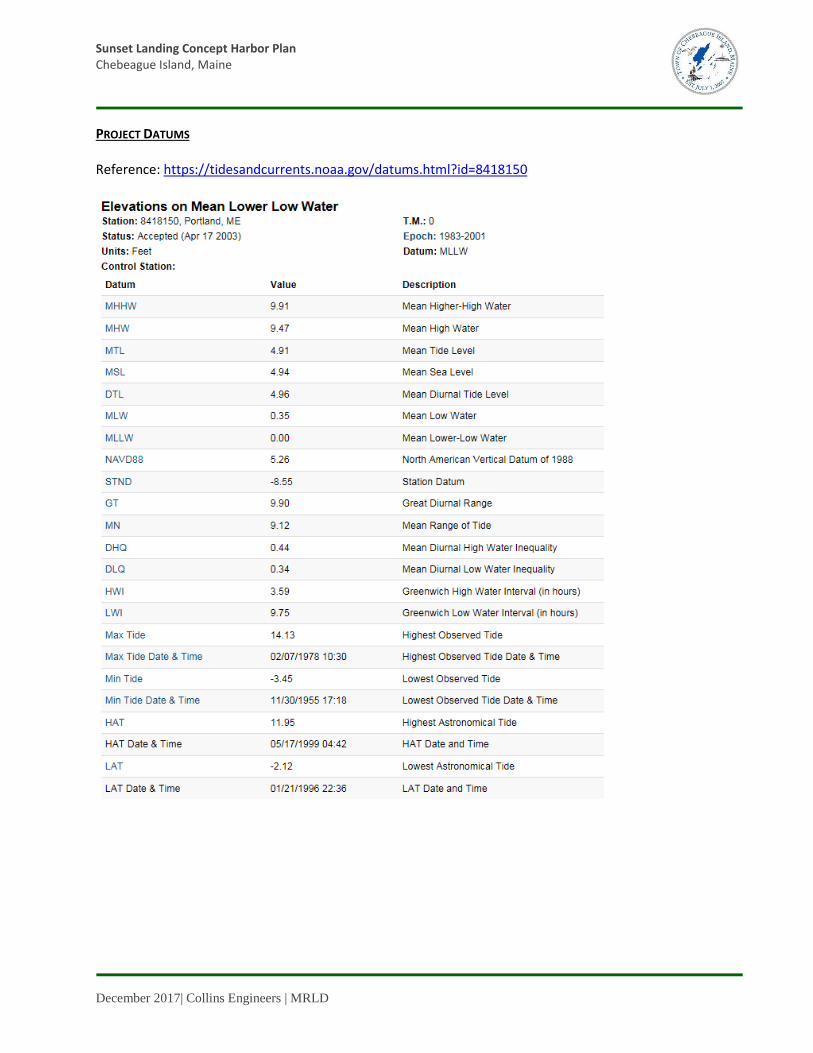
PROJECT DATUMS Reference: https://tidesandcurrents.noaa.gov/datums.html?id=8418150

Sunset Landing Concept Harbor Plan Chebeague Island, Maine
December 2017| Collins Engineers | MRLD
BASE FLOOD ELEVATION Reference: Flood Insurance Study Volume 2 of 4, FEMA, 28 March 2018 Preliminary Firm, FEMA, 14 April 2017
Sunset Landing Concept Harbor Plan Chebeague Island, Maine
December 2017| Collins Engineers | MRLD
SEA LEVEL RISE Reference: Town of Chebeague Island Sea Level Rise Vulnerability Assessment, Greater Portland Council of
Governments, April 2016.
Assume 2-ft rise for 50-year design life (2070)

Sunset Landing Concept Harbor Plan Chebeague Island, Maine
December 2017| Collins Engineers | MRLD
EXCEEDANCE PROBABILITY LEVELS AND TIDAL DATUMS Reference: Town of Chebeague Island Sea Level Rise Vulnerability Assessment, Greater Portland Council of
Governments, April 2016. High and low annual exceedance probability levels are shown relative to the tidal datums and the geodetic North American Vertical Datum (NAVD88), if available. The levels are in meters relative to the National Tidal Datum Epoch (1983-2001) Mean Sea Level datum at most stations or a recent 5-year modified epoch MSL datum at stations with rapid sea level rates in Louisiana, Texas, and Alaska. On the left are the exceedance probability levels for the mid-year of the tidal epoch currently in effect for the station. On the right are projected exceedance probability levels and tidal datums assuming continuation of the linear historic trend.
Assume 2018 data with SLR for maximum above (+) Assume 1983-2001 data for maximum below (-)

Sunset Landing Concept Harbor Plan Chebeague Island, Maine
December 2017| Collins Engineers | MRLD
WIND/WAVE DATA Reference: Sunset Landing Concept Harbor Plan Stakeholder Meeting Summary Notes, 15 August 2018 - Wind-Wave Conditions
• W, NW, and N winds are similar at Sunset as at Stone Pier, but Sunset does not benefit from protection afforded by Littlejohn Island and Cousins Island. (W winds at Stone Pier are broken up by Cactus Point and the Great Bar, at least at low tide.)
• WNW wind at Sunset is not protected by Basket Island. The previous wave study was incorrect in assuming protection from Basket (anecdotally the author agreed but would not re-issue the study). True fetch for analysis should extend to the mainland shore.
• Although the fetch distance as noted above may not be accurate, the attendees felt that the maximum wave heights identified in the previous report are appropriate, just not necessarily for the specific wind directions indicated in the report. Applying the indicated maximum wave heights from a westerly wind is likely more representative of the site conditions.
Reference: Sunset Landing Property Analysis – Chebeague Island, ME, Roberge Associates Coastal Engineers,
LLC, November 2015.

Sunset Landing Concept Harbor Plan Chebeague Island, Maine
December 2017| Collins Engineers | MRLD

Sunset Landing Concept Harbor Plan Chebeague Island, Maine
December 2017| Collins Engineers | MRLD
Figure 3 - Wave Summary

Sunset Landing Concept Harbor Plan Chebeague Island, Maine
December 2017| Collins Engineers | MRLD
EELGRASS Reference: Email from Clement, Jay L. to Wally Mosher, 22 October 2018
Subject: Sunset Harbor Landing Concept Study - questions for ACOE Wally: Any of your concepts will require Corps and Maine DEP permitting. For structures over eelgrass it is pretty common for at least the Corps to require compensatory mitigation in the form of an in-lieu fee payment. This may be at a diminished rate if the impacts are indirect (e.g. shading) vs. direct (e.g. filling or dredging). The permitting for just structures in navigable waters is pretty straightforward; most applications of that nature qualify for our Maine General Permit. Dredging complicates the process but not unduly so. For any project involving dredging, the key questions are typically how much, where will the material be disposed of, and what level of testing (and at what cost) will be required to ascertain the level of contaminants in the sediment if any. That is leg work that the Corps and DEP work with you on in advance of any permit application and the back and forth can take some time. Depending on the amount and intensity of sediment testing, it can also be an added cost. And if you end up dredging eelgrass, something we try to discourage, that'll definitely cost you in terms of compensatory mitigation. Neither the Corps nor the DEP dictate which of your preliminary designs is more or less likely to receive permits, we generally leave the initial proposal up to you. You're already working with Prock evidently, so they can probably break down the relative costs of your various options. But we would encourage a pre-application meeting as soon as you believe you've settled on a preferred design. This would likely be held at the DEP's Portland office and we'd join in. We'd then be able to better outline the various steps in the process and discuss any potential red flags. I'm copying Colin Greenan from my office as he'd likely be the one to process any future application. Alison from the DEP is copied as well - when necessary, she'll determine who from her team will be the project analyst. Jay Reference: Second Email from Clement, Jay L. to Wally Mosher, 22 October 2018
Subject: Sunset Harbor Landing Concept Study - questions for ACOE Direct impacts to eelgrass would generally be $4.30 per square foot of impact multiplied by a factor of two. This would represent the high end of the cost. Indirect impacts would be more of a case by case determination and would generally be less than that. Dredging per se wouldn't require compensatory mitigation unless you're going to dredge eelgrass. Jay

Sunset Landing Concept Harbor Plan Chebeague Island, Maine
December 2017| Collins Engineers | MRLD
Reference: Email from Brewer, Angela D. to Wally Mosher, 25 October 2018 – Subject: Sunset Harbor Landing Concept Study - questions for DEP regarding eelgrass disturbance
Wally, I appreciate you asking for feedback. As you know, eelgrass has been mapped since the 1990s pretty much around the perimeter of Chebeague. I have no reason to think there isn’t an eelgrass resource at those three locations now, but I am awaiting delineation of all beds around Chebeague as part of a Casco Bay-wide survey I coordinated this year. I should know distribution and percent cover of the eelgrass at your proposed study locations by the end of the year. Hopefully this new information can help avoid as much eelgrass impact as possible. Regarding impact minimization, my preference a marine biologist that values the ecosystem services of eelgrass would be to place structures over the narrowest fringe of lowest percent cover eelgrass possible, and as high over the water surface as possible. Indirect impacts of shading, from docks/floats, piers or vessels, fragment functional beds and reduce available habitat for marine species, not to mention other nearshore benefits. I am happy to speak to more detailed pros and cons at a pre-app.

Sunset Landing Concept Harbor Plan Chebeague Island, Maine
December 2017| Collins Engineers | MRLD
COMMERCIAL FISHING Reference: Email from Jeff Putnam. to Herb Maine (cc Dan O’Connor), October 2018
Subject: Re: Sunset Landing Update
Hi Herb, Thank you for keeping me involved in the planning discussions. I would be happy to talk with the folks from Collins, I can be reached at 650-3327. In short, I feel that the Stone Pier is an adequate facility for the 3 weeks in early June and late november that fisherman set of take up traps there. I hope that younger generations are involved in aquaculture and commercial fishing from Chebeague but so far the numbers do not show increased activity. From a cost/benefit standpoint I have a hard time seeing that public investment into a facility to support marine use by a dwindling number of fishermen makes sense. I have a couple of fisherman in mind that may have different perspectives on sunset, I will ask them if they would speak with Collins and follow up with Dan and Herb on that. thanks, -Jeff20
20 Collins contacted Mr. Putnam 25 October 2018 via phone and left a message. There has been no further communication.

Sunset Landing Concept Harbor Plan Chebeague Island, Maine
December 2017| Collins Engineers | MRLD
ICE Reference: Sunset Landing Concept Harbor Plan Stakeholder Meeting Summary Notes, 15 August 2018 – Ice
Conditions
• Ice can pack in and out similar to Stone Pier. • CTC does their own ice breaking at Stone Pier. USCG icebreaker was used during the 2014-2015
winter at Stone Pier, before that it is believed that USCG icebreaking was in the 1990s. • At Sunset, the exposed bedrock to the north collects ice at low tide then releases it to flow south to
the site. Then ice collects in the ‘hook’ to the south and eventually flows north again past the site. • Dynamic aspects of accumulated ice are higher at Sunset versus Stone Pier. Accumulated ice is a
concern. • Bennett’s Cove is less susceptible to ice. • Prior to the meeting, photographs of ice condition in March 2015 were forwarded to Collins.
Reference: Email from Nichols, Robert F BOSN3 to Wally Mosher, 16 October 2018
Subject: Chebeague Island planning & ice breaking Good Morning Mr. Mosher As per Cheryl’s request, the following are answers to specific questions she had and a brief overview of our procedure for managing domestic ice breaking. Question 1. What is your local knowledge of the ice conditions around the area we will be working? Answer: The ice conditions in this area very greatly from year to year, some years we see no accumulative ice and other years (as in 2015) that area had significant ice. Sorry for such an ambiguous answer but it is virtually impossible to predict, so that is why we prepare for the worst-case scenario. Question 2. General overview of the ice breaking services? Answer: In general, the Coast Guard performs ice-breaking for 3 purposes. Search and rescue; flood relief; and to support the reasonable demands of commerce. At Sector Northern New England, we monitor environmental conditions and ice formation in all ports, harbors and federally marked rivers from the U.S./Canadian border to the NH/MA border. We support this mission with a small fleet of Coast Guard Cutters that remain dedicated to ice breaking throughout the winter months. Question 3. Procedures for requesting ice breaking assistance? Answer: All requests should be directed to the Sector Northern New England Command Center at (207) 767-0303. We will prioritize these requests on a case-by-case basis. Vessels and facilities should be ready to provide additional information on the criticality of the request and the timeframe in which ice breaking resources are needed. Question 4. What priority may be given to an island’s water transportation connection to the mainland? Answer: Our priorities are as follows; a. Help facilitate Search and Rescue

Sunset Landing Concept Harbor Plan Chebeague Island, Maine
December 2017| Collins Engineers | MRLD
b. Urgent response to vessels that have a high probability of becoming hazardous (vessel beset in ice). c. Exigent Community services, this is where we support communities that have a need for fuel, food, medical supplies, etc.(most likely any assistance you would be requesting would fall under this category). Question 5. Potential alternatives if USCG does not have the resources to aid? Answer: There are tug operators that will conduct commercial ice breaking upon request. I suggest you contact your local harbor master for specific recommendations.
Figure 1 - Ice flows at residential pier, courtesy of Paul Belesca, 10 August 2018

650 Is
ling
ton S
treet,
Suite
1P
ort
smouth
,NH
03801
voic
e: (6
03) 3
34-4
742
fax:
(603) 3
34-4
745
web
: co
llinse
ng
r.co
m
N

650 Is
ling
ton S
treet,
Suite
1P
ort
smouth
,NH
03801
voic
e: (6
03) 3
34-4
742
fax:
(603) 3
34-4
745
web
: co
llinse
ng
r.co
m
N

W
Ap
pro
xim
ate
Lo
cati
on
Of
Ab
utt
er's P
rop
erty L
ine
(typ
ica
l)
N/F
Belesca
Book 15111, Page 224
"
O
ld
P
ie
r
R
o
a
d
"
Dug Well
Well
Old Dump
Old Foundation
TP2
TP3
TP4
TP1
Beach
Beach
USGS Sunset
USGS Sunset 2
USGS Sunset 1
Book 10609, Page 329
Stewart
N/F
Found #6 Steel Rebar
Gravel
Drive
Sign
Lawn
(
t
y
p
i
c
a
l
)
E
d
g
e
O
f
W
o
o
d
s
w/Porch
Dwelling
Utility Pole
(typical)
E
d
g
e
O
f
W
e
t
l
a
n
d
(
t
y
p
i
c
a
l
)
S
ta
ir
s
(
S
e
e
N
o
t
e
1
7
)
(8" up)
(2" up)
Found 7/8" Iron Pipe
(6" up)
Found 7/8" Galv. Iron Pipe
(14" up)
Found #6 Steel Rebar in
Found 1 3/4" Galv. Iron Pipe
(9" up/Leaning)
(2" up)
Oak
Former
Spring
Elizabeth Road
N80°45'52"W
517
.63
'
40
5.7
7'
N06°28'17"E
46
.56
'
S80°34'40"E
73
.4
7'
N05°18'15"E
64
0.1
0'
N83°20'01"E
S
3
7
°
0
0
'0
0
"
W
4
8
7
.
7
8
'
2
4
6
.7
6
'
S
16
°3
2
'2
6
"E
(T
ie L
in
e)
per Book 1938, Page 182
Lot Created 11-01-1948
Chase to Groves
(
T
i
e
L
i
n
e
)
(See Plan Reference 8)
(See Plan Reference 11)
Highest Annual Tide (HAT) 2014 per NOAA = 6.5'
10'±
40'±
"G
re
at C
ov
e
Base Flood Elevation (BFE) per FEMA Preliminary Maps = 15'
Base Flood Elevation per current FEMA Maps = 9.4' (10' NGVD29)
Gravel Way
CMP7.1
CMP7.2
S
tew
art R
esid
en
ce
Driv
ew
ay
T
o
Found 4" x 5" Irregular Stone
(10" up)
w/Possible Drill Hole
CMP7
Found #6 Steel Rebar
(8" up)
Found #6 Steel Rebar
(7" up)
40" Triple
U
p
la
n
d
Book 10609, Page 329
Stewart
N/F
(See Plan Reference 8)
Fo
rm
er L
in
es o
f D
iv
isio
n
(ty
pica
l)
per Book 1831, Page 118
Lot Created 07-15-1946
per Book 1893, Page 359
Lot Created 11-01-1947
per Book 1907, Page 315
Lot Created 03-24-1948
0.6
'
0.15
'
per Book 1879, Page 407
Lot Created 08-09-1947
per B
oo
k 3
270
, Page 176
Lin
e Created
04
-07-19
72
5o
' Wid
e P
er P
lan
Refe
ren
ces 3
& 4
40
' Wid
e P
er P
lan
Refe
ren
ces 1
0 &
11
Edge
Of
M
ow
ed
L
a
w
n
Oak
22" Twin
La
wn
Benchmark Disk
(typical)
L
o
t L
in
e
s
P
e
r
P
la
n
R
e
f. 4
(
ty
p
ic
a
l)
Routes
Sign
Sign
7
5
'S
e
t
b
a
c
k
2
5
0
'
S
e
t
b
a
c
k
"
S
u
n
s
e
t R
o
a
d
"
a
.k
.a
.
Cabin
Remains
(1" up/Leaning)
Found 7/8" Galv. Iron Pipe
Barn
Chase to Groves
Chase to Groves
Chase to Groves
Chase to Groves
per Book 1961, Page 268
Lot Created 11-29-1948
Chase to Bryson
1909 1933
8
1
5
'±
Sunset Landing
Pier Remains
650 Is
ling
ton S
treet,
Suite
1P
ort
smouth
,NH
03801
voic
e: (6
03) 3
34-4
742
fax:
(603) 3
34-4
745
web
: co
llinse
ng
r.co
m
N

650 Is
ling
ton S
treet,
Suite
1P
ort
smouth
,NH
03801
voic
e: (6
03) 3
34-4
742
fax:
(603) 3
34-4
745
web
: co
llinse
ng
r.co
m
N

650 Is
ling
ton S
treet,
Suite
1P
ort
smouth
,NH
03801
voic
e: (6
03) 3
34-4
742
fax:
(603) 3
34-4
745
web
: co
llinse
ng
r.co
m
N

W
Ap
pro
xim
ate
Lo
cati
on
Of
Ab
utt
er's P
rop
erty L
ine
(typ
ica
l)
N/F
Belesca
Book 15111, Page 224
"
O
ld
P
ie
r
R
o
a
d
"
Dug Well
Well
Old Dump
Old Foundation
TP2
TP3
TP4
TP1
Beach
Beach
USGS Sunset
USGS Sunset 2
USGS Sunset 1
Book 10609, Page 329
Stewart
N/F
Found #6 Steel Rebar
Gravel
Drive
Sign
Lawn
(
t
y
p
i
c
a
l
)
E
d
g
e
O
f
W
o
o
d
s
w/Porch
Dwelling
Utility Pole
(typical)
E
d
g
e
O
f
W
e
t
l
a
n
d
(
t
y
p
i
c
a
l
)
S
ta
ir
s
(
S
e
e
N
o
t
e
1
7
)
(8" up)
(2" up)
Found 7/8" Iron Pipe
(6" up)
Found 7/8" Galv. Iron Pipe
(14" up)
Found #6 Steel Rebar in
Found 1 3/4" Galv. Iron Pipe
(9" up/Leaning)
(2" up)
Oak
Former
Spring
Elizabeth Road
N80°45'52"W
517
.63
'
40
5.7
7'
N06°28'17"E
46
.56
'
S80°34'40"E
73
.4
7'
N05°18'15"E
64
0.1
0'
N83°20'01"E
S
3
7
°
0
0
'0
0
"
W
4
8
7
.
7
8
'
2
4
6
.76
'
S
16
°3
2
'2
6
"E
(T
ie L
in
e)
per Book 1938, Page 182
Lot Created 11-01-1948
Chase to Groves
(
T
i
e
L
i
n
e
)
(See Plan Reference 8)
(See Plan Reference 11)
Highest Annual Tide (HAT) 2014 per NOAA = 6.5'
10'±
40'±
"G
re
at C
ov
e
Base Flood Elevation (BFE) per FEMA Preliminary Maps = 15'
Base Flood Elevation per current FEMA Maps = 9.4' (10' NGVD29)
Gravel Way
CMP7.2
S
tew
art R
esid
en
ce
Driv
ew
ay
T
o
Found 4" x 5" Irregular Stone
w/Possible Drill Hole
CMP7
Found #6 Steel Rebar
(8" up)
Found #6 Steel Rebar
(7" up)
40" Triple
U
p
la
n
d
Book 10609, Page 329
Stewart
N/F
(See Plan Reference 8)
Fo
rm
er L
in
es o
f D
iv
isio
n
(ty
pica
l)
per Book 1831, Page 118
Lot Created 07-15-1946
per Book 1893, Page 359
Lot Created 11-01-1947
per Book 1907, Page 315
Lot Created 03-24-1948
0.6
'
0.15
'
per Book 1879, Page 407
Lot Created 08-09-1947
per B
oo
k 3
270
, Page 176
Lin
e Created
04
-07-19
72
5o
' Wid
e P
er P
lan
Refe
ren
ces 3
& 4
40
' Wid
e P
er P
lan
Refe
ren
ces 1
0 &
11
Edge
Of
M
ow
ed
L
a
w
n
Oak
22" Twin
La
wn
Benchmark Disk
(typical)
L
o
t L
in
e
s
P
e
r
P
la
n
R
e
f. 4
(
ty
p
ic
a
l)
Routes
Sign
Sign
7
5
'S
e
t
b
a
c
k
2
5
0
'
S
e
t
b
a
c
k
"
S
u
n
s
e
t R
o
a
d
"
a
.k
.a
.
Cabin
Remains
(1" up/Leaning)
Found 7/8" Galv. Iron Pipe
Barn
Chase to Groves
Chase to Groves
Chase to Groves
Chase to Groves
per Book 1961, Page 268
Lot Created 11-29-1948
Chase to Bryson
1909 1933
8
1
5
'±
Sunset Landing
Pier Remains
650 Is
ling
ton S
treet,
Suite
1P
ort
smouth
,NH
03801
voic
e: (6
03) 3
34-4
742
fax:
(603) 3
34-4
745
web
: co
llinse
ng
r.co
m
N

650 Is
ling
ton S
treet,
Suite
1P
ort
smouth
,NH
03801
voic
e: (6
03) 3
34-4
742
fax:
(603) 3
34-4
745
web
: co
llinse
ng
r.co
m
N
